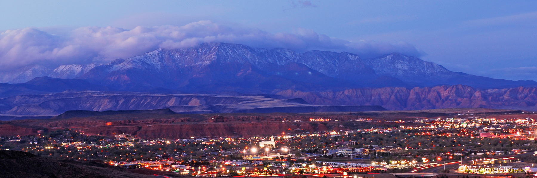
From the St. George Spectrum & Daily News (Joan Meiners):
Last week, Utah Gov. Spencer Cox issued an executive order declaring a statewide drought emergency. In the press release that followed, he urged Utahns to “evaluate their water use and find ways to save not only because of current drought conditions but also because we live in one of the driest states in the nation.”
[…]
These measures are needed because, according to the Governor’s March 17 release, “following a record dry summer and fall, this winter’s snowpack is about 70% of average for the year. For snowpack to reach average, Utah’s mountains would need to receive the remaining 30% before it starts to melt significantly, typically the first week in April. There is around a 10% chance of this occurring.”
[…]
In the very first edition of The Water Tap, The Spectrum & Daily News surveyed locals about their water use and found that, on average, we are using twice as much water at home as we think we are using (local estimated their home use at 127 gallons per day compared to the USGS-calculated 248). This is despite the fact that a majority of survey respondents reported being aware that water scarcity is an issue in southern Utah and said that they already make an effort to conserve water at home…
To be fair, some of our higher local water use is simply due to the realities of our environment here in the northern range of the Mojave Desert. Being one of the driest states — as Governor Cox pointed out — our outdoor landscapes will require more water to achieve the same result compared to lawns growing in Missouri or Virginia, due to drier soils and higher evaporative loss.
But that’s exactly why several other southwestern states sponsor programs to encourage people to replace their lawns with desert-friendly landscaping, or xeriscaping. Southern Utah does not currently offer any such turf removal incentives and, in past interviews, local water managers have been loathe to condemn the abundance of residential lawns, parks and golf courses throughout the region.
The initial The Water Tap also noted that domestic water use from the public supply makes up just 15% of total water use in Utah, while irrigation accounts for 72% of use, mostly to support local water-intensive crops like alfalfa. The fourth week of The Water Tap covered recent research findings that up to 55% of water throughout the Colorado River basin is spent irrigating cattle-feed crops.
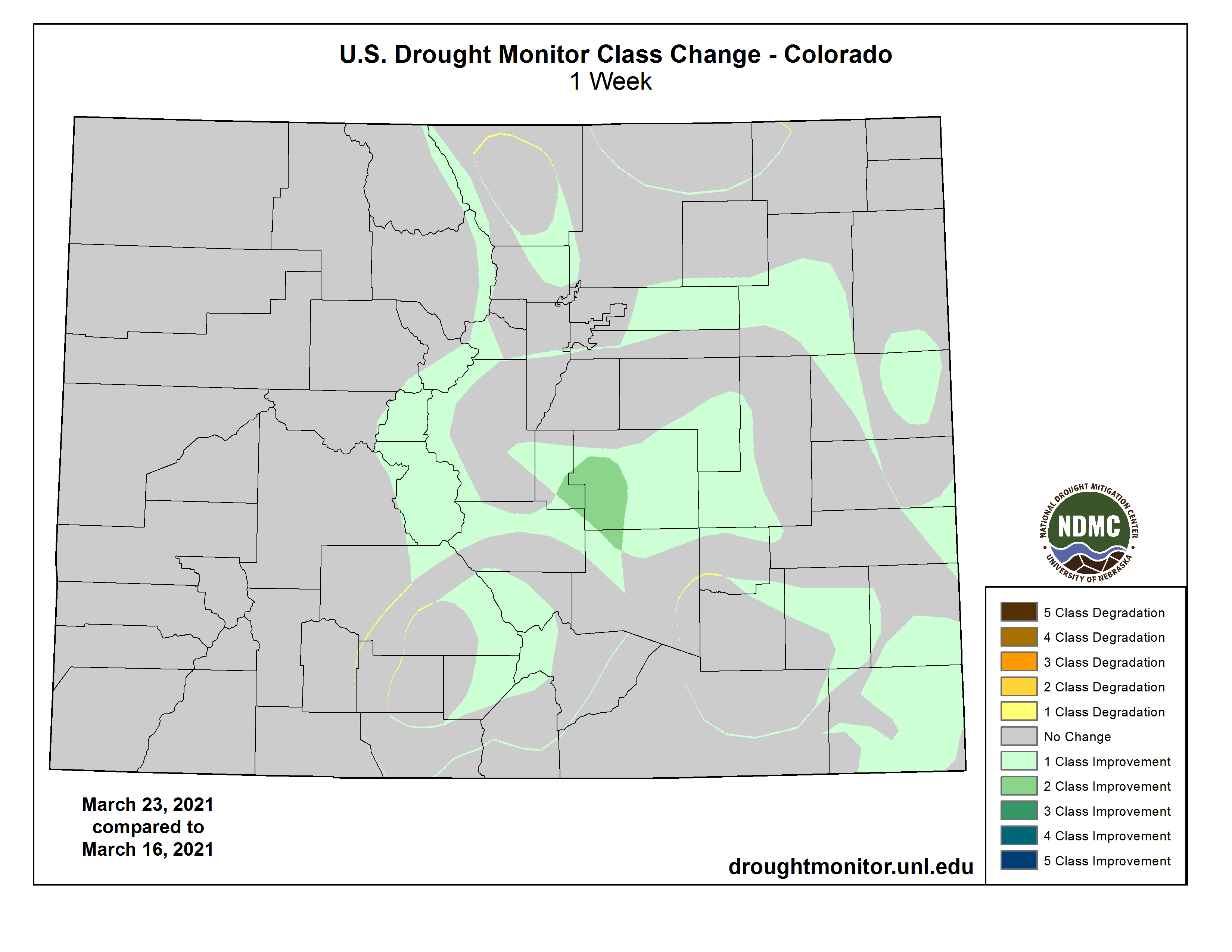
Additional moisture following a major snowstorm two weeks ago has provided additional drought relief to portions of Colorado’s eastern plains and mountain areas according to the latest update from the National Drought Mitigation Center.
Colorado Drought Monitor one week change map ending March 23, 2021.
The most notable change appeared in southwest El Paso County, where extreme drought decreased two categories to moderate conditions. Southern Teller and a small portion of northern Pueblo counties experienced a similar two category improvement.
Elsewhere in El Paso, Elbert, Lincoln, Pueblo, Prowers and Crowley counties, extreme drought moved into the severe category. Extreme conditions also decreased in Baca and Las Animas counties.
Central Kiowa County remained in extreme drought, while a small area of extreme conditions in the northwest of the county moved to severe.
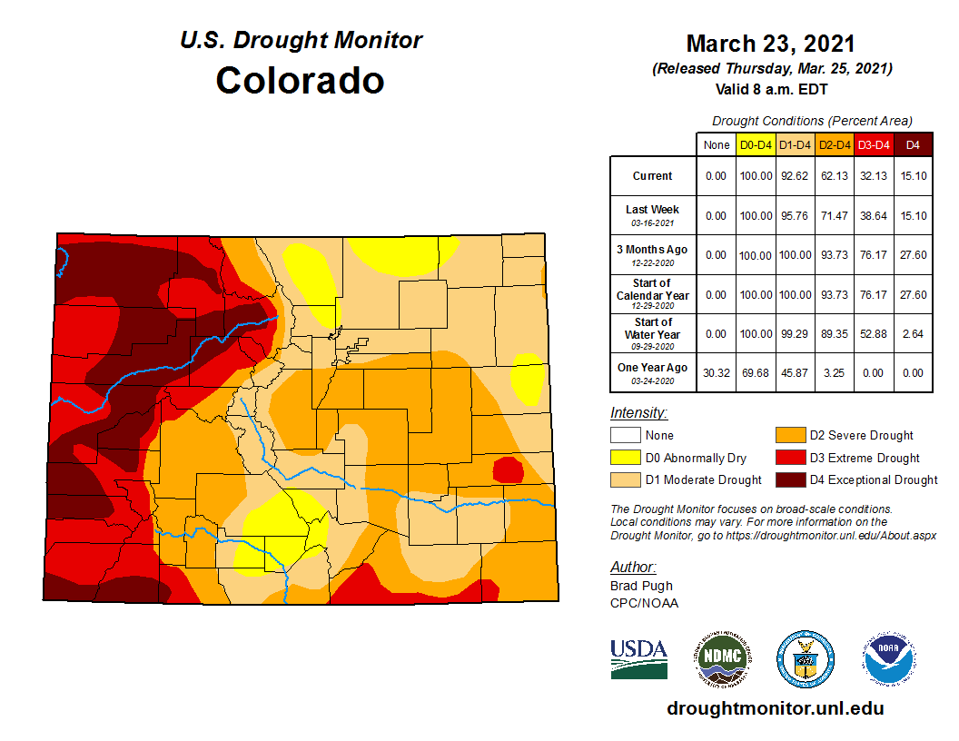
Colorado Drought Monitor March 23, 2021.
Areas of abnormally dry conditions expanded to replace moderate drought in the San Luis Valley and northern Colorado. Abnormally dry conditions also appeared in southern Yuma and eastern Kit Carson counties.
No improvement was noted in western Colorado, which has been dominated by extreme and exceptional drought for months.
Recent heavy snowfall brought snow water content close to average for mid-March across most of Colorado despite the ongoing areas of significant drought.
Colorado Drought Monitor March 16, 2021.
Overall, 15 percent of the state is in exceptional drought, unchanged from the prior week. Extreme drought fell from 24 percent to 17, while severe conditions dropped to 30 percent from 33. Moderate drought increased from 24 to 30 percent, while abnormally dry conditions increased from four to seven percent, offsetting areas of more significant drought. None of Colorado is free from drought. Percentages do not total 100 due to rounding.
A new computer model of climate effects and human economic activity reveals weaknesses and strengths of hundreds of river and water basins across the globe, as we face increasing levels of climate stress (source: Drought.gov)
Here’s the release from Tufts University (Mike Silver):
Computer model shows human economic activity can transmit and magnify climate change impact
Water scarcity is often understood as a problem for regions experiencing drought, but a new study led by Tufts University researchers finds that not only can localized water shortages impact the global economy, but changes in global demand can have positive and negative ripple effects in river basins across the globe.
In addition to Tufts engineers, the team included experts from the Joint Global Change Research Institute at the Pacific Northwest National Laboratory, and Cornell University.
“We’re finding that water scarcity dynamics are more complicated than traditionally acknowledged,” said Flannery Dolan, a graduate student at Tufts University and lead author of the study. “Changing water supply due to climate change is only part of the story. Regional water scarcity is also driven by changes in global water demands that are often hard to anticipate.”
The study, “Evaluating the economic impact of water scarcity in a changing world,” was published March 26 in Nature Communications, and uniquely captures the interdependent effects of global trade, population and technological growth, climate change, and land management decisions on regional river basins’ water scarcity and economic capacity to adapt to that scarcity.
The researchers used a computer model to simulate thousands of scenarios that reflect a broad array of potential climate, socioeconomic, and hydrologic (earth water cycles and management) conditions in 235 major river basins to better understand how regional water scarcity can have far-ranging impacts on the global economy. Those effects can include altering global trade and consumption patterns in industries such as agriculture, energy, transportation, and manufacturing.
“We are looking at water scarcity as a globally connected and multi-sector phenomenon,” said Jonathan Lamontagne, assistant professor of Civil and Environmental Engineering at Tufts University and corresponding author of the study. “As a result, the study reveals some interesting and sometimes unexpected insights into how local conditions can have reverberations across the globe.”
The research found that global trade dynamics and market adaptations to regional water scarcity can result in positive or negative economic outcomes in every regional river basin considered in the study, depending on both water supply (rainfall, snowmelt, and ground water), and demand-side factors like agricultural production, power generation, and municipal use.
Graphic credit: Western Water Assessment
The course and the major tributaries of the Indus in a geographical map of Upper South Asia. By The Edinburgh Geographical Institute, John Bartholomew and Company. Amended by Fowler&fowler (talk) 20:07, 6 February 2021 (UTC) – From personal copy (of Fowler&fowler (talk)) of Imperial Gazetteer of India volume 26, Atlas, published by the Secretary of State for India in Council, Oxford University Press, 1909, Figure 4, Orographical Features, Public Domain, https://commons.wikimedia.org/w/index.php?curid=99629481
For instance, in the lower Colorado River basin, the worst economic outcomes arise from limited groundwater availability and high population growth, but that high population growth can also prove beneficial under some hydrologic conditions. In contrast, the future economic outcomes in the Indus Basin depend largely on global land-use policies that discourage carbon emissions that can, in turn, encourage overuse of groundwater supplies.
“What is happening elsewhere in the world through differences in regional choices related to energy transitions, how land is being managed, as well as different regional water demands and adaptive choices, can shape relative advantages and disadvantages of a region’s water intensive economic activities,” said Patrick Reed, the Joseph C. Ford Professor of Civil and Environmental Engineering at Cornell.
Restrictions in water availability usually lead to a negative regional economic impact, but the research revealed that some regions can experience a positive economic impact if they hold an advantage over other water basins and become a virtual exporter of water. The Orinoco basin in Venezuela, for example, usually has a reliable supply of water and is often in a relative position that can benefit when other regions are under stress, according to the researchers.
The study also found that small differences in projections for future climate conditions can yield very large differences in the economic outcomes for water scarcity.
“Human activities and market responses can strongly amplify the economic effects of water scarcity, but the conditions that lead to this amplification vary widely from one basin to the next,” said Lamontagne.
A river basin can be considered economically robust if it is able to adapt to drought with alternative sources of water or adjust economic activity to limit usage. If a basin is unable to adapt its supply options and if prolonged water scarcity leads to persistent economic decline, then the researchers describe the loss in water basin adaptive capacity as having reached an ‘economic tipping point.’
For example, in the Indus region in South Asia, the water supply is under stress due to heavy agricultural use and irrigation leading to unsustainable consumption of groundwater, which places it close to the tipping point.
The conditions that lead to these tipping points are highly variable from basin to basin, depending on a combination of local factors and global conditions. In the Arabian Peninsula, low groundwater availability and pricing of carbon emissions are key factors. In the lower Colorado River basin, a mixture of low groundwater availability, low agricultural productivity, and strong economic demands from the U.S. and Europe lead to tipping points.
“It is noteworthy that the lower Colorado River basin has some of the most uncertain and widely divergent economic outcomes of water scarcity of the basins analyzed in this study,” said Reed. “This implies that assumed differences in regional, national and global human activities as well as the intensity of climate change can dramatically amplify the uncertainty in the basin’s outcomes.”
As climate change makes the physical and economic effects of water scarcity more challenging for policy makers to understand, the researchers hope their work will provide the basis for similar analyses and draw attention to the importance of expanded data collection to improve modeling and decision making.
Click here to read the update (Tracy Kosloff and Megan Holcomb):
A cold February came to a close as the first below average temperature month since October 2019 and the 25th coldest month on record in 127 years. The eastern side of the continental divide benefited more than the rest of Colorado from recent March snowstorms. The last 11 months (Apr 2020 to Feb 2021) are the driest on record for Colorado as a whole (when compared to the same 11 months for the period of record). The dryness will reduce springtime runoff, especially in western Colorado. While a warm and dry pattern has continued this winter, conditions are not as severe as they were in the fall with localized drought monitor improvements due to recent precipitation.
Colorado Drought Monitor March 23, 2021.
The U.S. Drought Monitor from March 23rd recorded recent improvements. Notably, a 2-category change in a one week period was observed in north and central areas of eastern Colorado between March 9-16th. The last 2-category improvement was recorded during the September 2013 floods. Exceptional (D4) drought currently covers 15% of the state; extreme (D3) drought covers 17%; severe (D2) drought covers 30%; moderate (D1) drought covers 30%; and recent precipitation created patches of abnormally dry (D0) areas in 7% of the state.
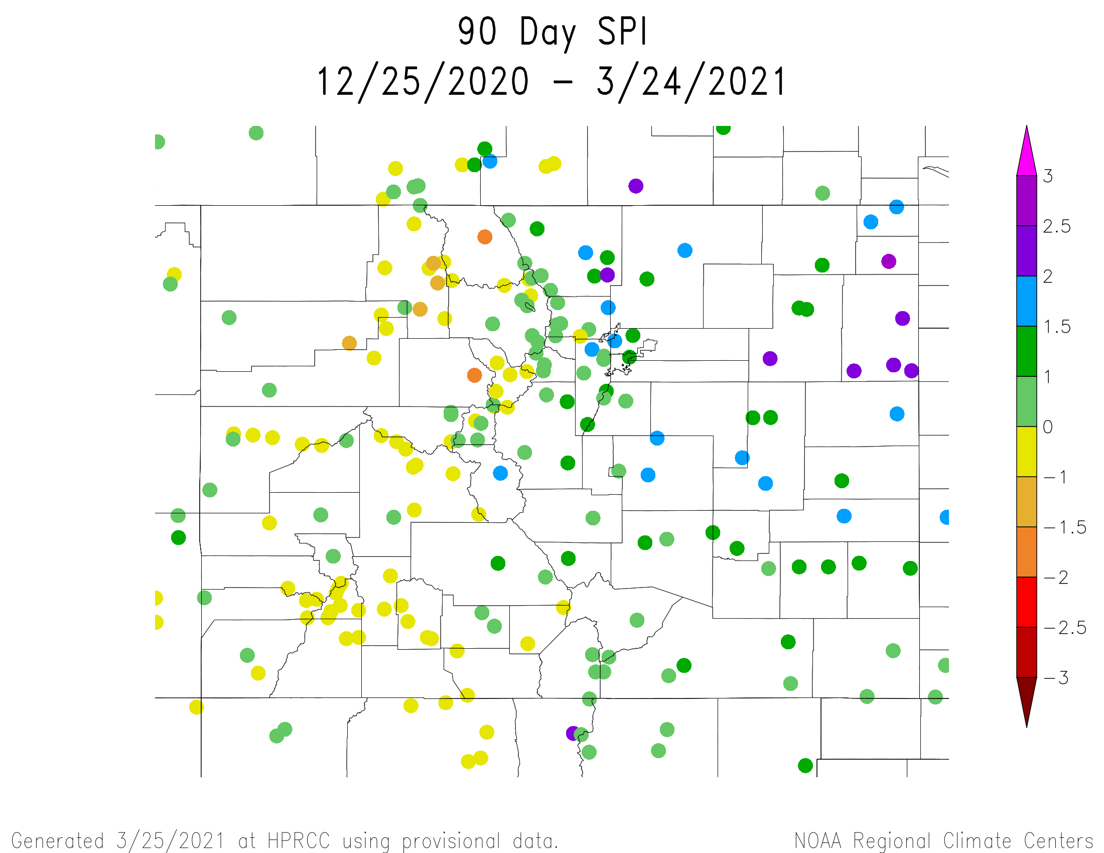
The 90-day Standardized Precipitation Index (SPI) values from Dec. 14 to Mar. 15 highlight continued dry conditions on the western slope. Eastern Colorado’s SPI data points reflect areas of above average precipitation after January and March snowstorms. The 12-month SPI map depicts the long-term drought conditions due to precipitation deficits of 2020 across the state.
The NOAA Climate Prediction Center three month outlook indicates the current La Niña pattern may weaken by the spring and revert to neutral conditions in the summer. Above normal temperatures and below average precipitation are anticipated in the upcoming months. In contrast, March was expected to bring below average precipitation, which was not the case.
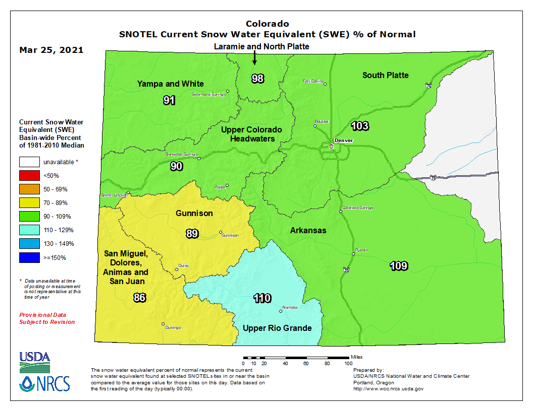
Colorado statewide snowpack basin-filled map March 25, 2021 via the NRCS.
As of March 17th, statewide snowpack is 83% of normal. Statewide reservoir storage is currently at 85% of average. Extreme soil moisture deficits and below normal precipitation means all basins should prepare for a low runoff year. The continuance of drought is expected through 2021 and the State Drought Plan remains in Phase 3 activation.
Water providers across the state report average to slightly below average storage levels and near normal winter demands. Drought management planning and potential restrictions are being discussed through multiple coordination groups. Stakeholders can follow along with state drought response actions and activities through public engagement pages for the Municipal Water Task Force and Agricultural Impact Task Force.
Moraine Park and the headwaters of the Big Thompson River in Rocky Mountain National Park. Moraine Park is on the east side of the park and of the continental divide, near the town of Estes Park. This region has a number of areas call “parks”, which refer to open, level areas in the mountains, usage which comes from the French word parque. The names of these areas predate the establishment of the national park and are unrelated to the use of the word “park” in that context. By The original uploader was Kbh3rd at English Wikipedia. – Transferred from en.wikipedia to Commons., CC SA 1.0, https://commons.wikimedia.org/w/index.php?curid=1009783