Click on a thumbnail graphic to view a gallery of snowpack data from the NRCS.
Colorado statewide snowpack basin-filled map March 17, 2021 via the NRCS.
Statewide Basin High/Low graph March 16, 2021 via the NRCS.
Arkansas River Basin High/Low graph March 16, 2021 via the NRCS.
Upper Colorado River Basin High/Low graph March 16, 2021 via the NRCS.
Gunnison River Basin High/Low graph March 16, 2021 via the NRCS.
Laramie and North Platte Basin High/Low graph March 16, 2021 via the NRCS.
Upper Rio Grande River Basin High/Low graph March 16, 2021 via the NRCS.
San Miguel, Dolores, Animas, and San Juan Basin High/Low graph March 16, 2021 via the NRCS.
South Platte River Basin High/Low graph March 16, 2021 via the NRCS.
Yampa and White Basin High/Low graph March 16, 2021 via the NRCS.
FromThe Grand Junction Daily Sentinel (Dennis Webb):
Natural Resources Conservation Service data on Tuesday showed that snow water equivalent, or the amount of water in the state’s snow, is at 92% of median. That compares to 85% just before mid-month in February and only about three-quarters of normal around a month before that.
Snowpack in the Upper Colorado River Basin in Colorado is now sitting at 89% of median, compared to 82% a little more than a month ago, and the Gunnison River Basin is at 86%, a 7% increase during that same time period.
The state as a whole is now about three weeks from when it typically reaches its peak snowpack accumulation for the winter, according to the NRCS.
The weekend snow brought more than 27 inches of snow to Denver, making it the fourth-largest snowstorm in the city’s recorded history. But Erin Walter, a meteorologist for the National Weather Service in Grand Junction, pointed to some reports of high accumulations from the storm in and around the Western Slope. These included 19 inches on Douglas Pass, anywhere from 20 to 28 inches in the La Sal Mountains just over the Utah border, and 14 inches in Ouray.
Powderhorn Mountain Resort on Tuesday reported having received 8 inches in the previous 48 hours, with the Snowmass ski resort near Aspen having gotten nearly a foot over the same two days.
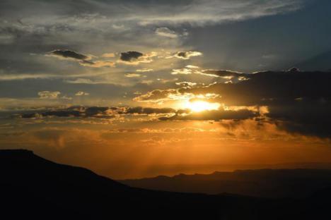
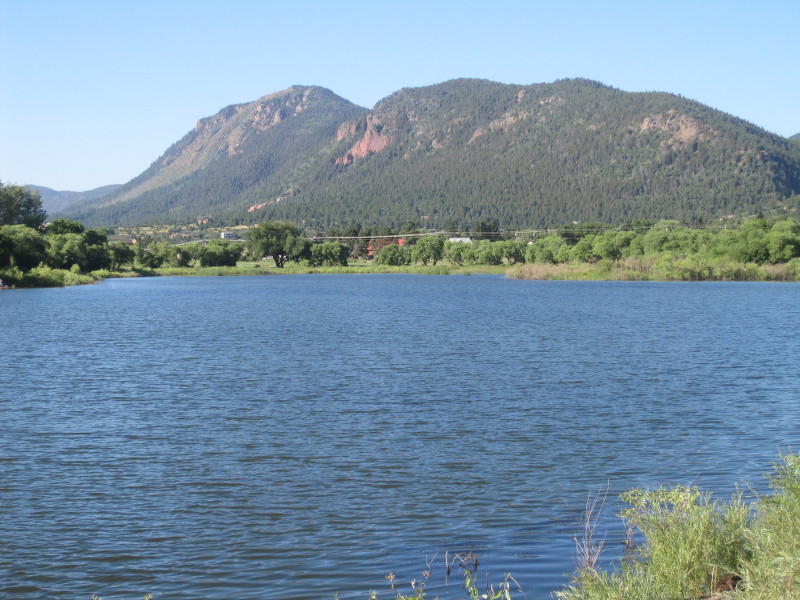
Grand Mesa Colorado sunset.
Snowpack levels at Grand Mesa NRCS measurement sites are now at between 76-77% of normal, after ranging from 62-72% of median just over a month ago, and just 46-57%, depending on the site, in mid-January…
Snowpack in major drainages in Colorado now ranges from 105% in the Upper Rio Grande Basin to just 82% in the combined San Miguel/Dolores/Animas/San Juan basins.
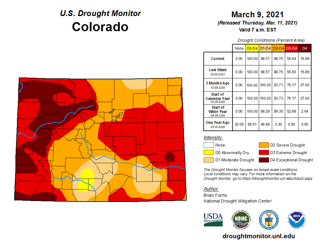
Colorado Drought Monitor March 9, 2021.
Water experts have continued to warn this winter that even a normal winter snowpack is expected to result in below-normal spring runoff due to dry soils. Almost all of Colorado remains in some level of drought, with a lot of western Colorado in extreme or exceptional drought, respectively the two worst categories, according to the U.S. Drought Monitor. Much of eastern and southern Mesa County is in exceptional drought, with the rest of the county in extreme drought…
Walter said March seems to be a typically wet month for Colorado, and it’s not uncommon to see snowpack levels move toward normal this time of year…
Unfortunately, the federal Climate Prediction Center is indicating above-average odds of above-normal temperatures and below-normal precipitation in Colorado over both the next month and next three months.
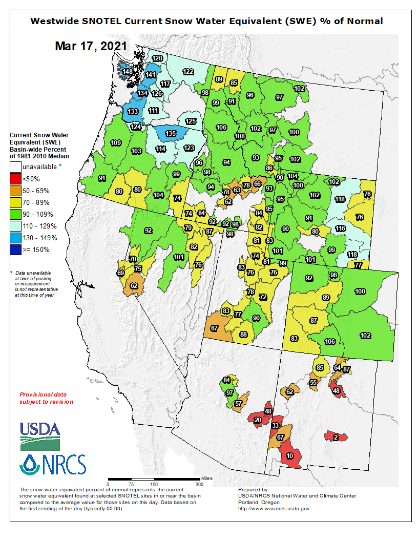
Here’s the Westwide SNOTEL basin-filled map for March 17, 2021 via the NRCS.
Westwide SNOTEL basin-filled map March 17, 2021 via the NRCS.
Denver got 2.88 inches of precipitation over 48 hours over the weekend. That’s more precipitation than it normally gets all of March and April combined, and many other spots in eastern Colorado also got two months’ worth of rain and melted snow.
The state climatologists say they expect a huge reduction in Colorado’s drought levels. The biggest relief will be east of the Continental Divide where most of the snow and rain fell, but the storm will not be a complete drought buster on its own…
Colorado mountain snowpack saw an incredible jump with this storm — the headwaters of the South Platte, Arkansas and Rio Grande river basins are now back up to average, while statewide we are just 9% below median.
The places that got the big 4-inch totals were between 7,000-9,000 feet in the foothills where they have been begging for a big one.
Monument and the Tri-Lakes were hit especially hard from last weekend’s storm, with snowfall totals up over 2 feet in some areas.
Palmer Lake amassed a whopping 28″ of snow from the storm, and experienced blizzard conditions nearly all day Sunday.
Many other areas in northern El Paso County and Teller County also came away with more than 20″ of snowfall…
As advertised, Colorado Springs probably saw the biggest range in totals from the storm. Southern sections of town came away with about 5″ of snowfall, while northern neighborhoods consistently reported more than a foot of snow…
The Colorado Springs Airport collected 6.4″ of snow, with a water equivalent of 0.59″.
Pueblo reported 3.8″ of snow and 0.49″ of liquid precipitation.
For the year, both cities are above average. In the Springs, we’ve seen more than double the value of a normal year so far.
The Bureau of Reclamation is pleased to announce the selection of Katrina Grantz as assistant regional director for its Interior Region 7 — Upper Colorado Basin.
Grantz, a 14-year Reclamation veteran, began her assignment March 14. As assistant regional director, she will oversee a range of water and hydropower programs in Arizona, Colorado, New Mexico, Texas, Utah and Wyoming.
“It is an honor and a privilege to serve with the dedicated employees of the Upper Colorado Basin Region,” said Grantz. “I look forward to working with our partners as we continue to make progress on important issues in the region, delivering water and power for the people of the American West.”
Grantz began her career with Reclamation in 2007 and progressed through increasing levels of responsibility. She began as a civil engineer in the Upper Colorado Basin Region performing reservoir operations and hydrologic modeling. She has served as the Glen Canyon Dam Adaptive Management program manager and most recently as the Safety and Technical Resources Division manager, overseeing regional issues of safety, security, dam safety, emergency management, water quality and engineering services.
“I am pleased to welcome Katrina to the Regional Director—s Office as the new assistant regional director,” said Regional Director Wayne Pullan. “With her extensive background and great ability, she will enhance the region—s ability to serve the public now and into the future.”
Leading the COVID-19 response for the Upper Colorado Basin Region, Grantz ensured employees— safety during the pandemic. She consistently informed employees of changing guidelines, set up protective guidance in offices, and made employee well-being a priority, all of which she will continue in her new leadership role.
Grantz—s experience includes volunteering for the Peace Corps for three years in Malawi, Africa, teaching math and physical science. She also conducted research in climate variability to improve water management in the American West at the Center for Advanced Decision Support in Water and Environmental Systems at the University of Colorado.
Grantz is a New Mexico native. She holds a doctorate and master—s degree in civil engineering from the University of Colorado, as well as bachelor—s degrees in physics and German from Grinnell College, Iowa.
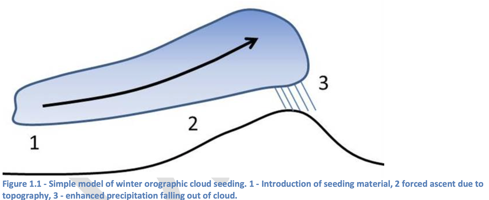
Graphic credit: “Literature Review and Scientific Synthesis on the Efficacy of Winter Orographic Cloud Seeding” — CIRES
FromE&E News (Chelsea Harvey) via Scientific American:
Interest in cloud seeding is growing as temperatures steadily rise, increasing drought risks in places like the Mountain West. But there’s a catch. Scientists aren’t sure how well cloud seeding works today, let alone in a warmer climate.
Amid growing concerns about water resources in the western U.S., scientists are working to answer those questions. Today, cloud seeding research represents the cutting edge of weather and climate science—a convergence of questions about the influence of warming on our dwindling water resources and our ability to control those consequences.
“Certainly we’re in a better position now to address that question than we were 10 years ago,” said Jeff French, an atmospheric scientist at the University of Wyoming. “The state of the science has progressed to the point that it is a question that we can and should be trying to address now.”
Cloud seeding can take a few different forms. In some places, it’s used to boost rainfall or prevent hailstorms. But in the U.S., it most commonly aims to enhance snowfall, and usually with silver iodide.
Extra snow can be a boon for water resources, especially in places like the drought-plagued West…
Boosting snowpack is being pursued with growing urgency. Much of the western U.S. has been gripped by drought for the last 20 years…
Weather experiments are notoriously difficult to conduct. The scientific gold standard would be a study that proves cloud seeding produced an outcome that definitely would not have happened without it. But that kind of research requires a combination of specialized experimental design and highly advanced technology.
For most of cloud seeding’s long history, it just wasn’t possible. Only within the last few years has technology advanced enough for researchers to really dig into the problem…
Today, cloud seeding operations take place in at least eight states across the western U.S., with varying levels of investment often shared among state agencies, utilities and private companies such as mountain resorts.
Cloud seeding programs in the upper Colorado River Basin, for instance, cost around $1.5 million each year. The costs are split among state agencies in Colorado, Utah and Wyoming, where the majority of the operations take place, as well as Nevada, California, New Mexico and Arizona, which also stand to benefit from increased flow on the Colorado River.
In the last few years, cloud seeding has featured more prominently in drought management strategies across the West. The cost-sharing agreement in the Colorado River Basin was finalized in 2018, after states had spent years individually managing their cloud seeding operations. The agreement extends through the fall of 2026.
Since 2018, Wyoming and Colorado have strengthened their programs by investing in aerial cloud seeding operations—that’s seeding conducted by aircraft—in addition to the ground-based machines they already have scattered throughout the mountains.
These are relatively inexpensive investments, all things considered—a low risk for a potentially high reward. But is it actually making a difference?
Most programs point to statistical studies to justify their efforts. These studies indicate that seeded clouds can produce around 5% to 15% more snowfall compared with areas where no cloud seeding took place.
If that’s right, it puts the cost of cloud seeding at around a few dollars per acre-foot of water (equivalent to about half an Olympic-size swimming pool). That’s far less expensive than the cost of many other water-saving interventions, such as water conservation, recycling or desalination, which can cost hundreds of dollars per acre-foot.
Still, statistical studies don’t prove that cloud seeding is actually causing the heavier snowfall. That requires a more specialized scientific experiment—and only within the last few years have scientists finally been able to make that happen.
As recently as 2015, an extensive report prepared for the Bureau of Reclamation concluded that continued research is still warranted, but it noted that “the ‘proof’ the scientific community has been seeking for many decades is still not in hand.”
[…]
On Jan. 19, 2017, a research plane roared through the gray skies above Idaho’s Payette River Basin, spewing silver iodide into the air. Assembled on the snow-capped peaks below, snow gauges and portable radar machines were poised to measure the snow that scientists hoped would follow.
It was the beginning of an experiment that would turn cloud seeding science on its head. Known as the SNOWIE project—short for “Seeded and Natural Orographic Wintertime Clouds”—the study provided some of the first quantitative evidence that cloud seeding actually works.
For three days that January, weather conditions would align to set up the perfect cloud seeding experiment. The sky was cold and cloudy—but no snow was falling. Over the course of these three days, the research plane would make more than a dozen trips over the mountaintops, releasing the same amount of silver iodide each time.
“For three days there was cloud cover, but no snowfall, no natural precipitation,” said Katja Friedrich, an atmospheric scientist at the University of Colorado, Boulder, who helped lead the SNOWIE project. “We put the seeding material into the supercooled liquid cloud, and we were able to generate precipitation. And that was very revolutionary.”
Thanks to high-tech radar equipment, the scientists were able to monitor the response of the clouds from the moment the silver iodide was released into the air until the moment snow began to fall. Over the course of those three days, the scientists estimated that around 286 Olympic swimming pools’ worth of snow fell from the clouds they seeded.
Friedrich and her colleagues, including scientists from Colorado, Wyoming, Illinois and Idaho, published their findings in a groundbreaking paper last year in Proceedings of the National Academy of Sciences.
SNOWIE came in the midst of a kind of a renaissance for cloud seeding research in the United States. After years of relatively little scientific interest in weather modification, a series of projects over the last decade have paved the way for new insights.
Cloud Seeding targets North America. Map credit: North American Weather Modification Council
Scenes from the Seeded and Natural Orographic Wintertime Clouds: The Idaho Experiment (SNOWIE) project, which was undertaken in Idaho’s Payette Basin in winter 2017. Credit: Joshua Aikins via Aspen Journalism
Scenes from the Seeded and Natural Orographic Wintertime Clouds: The Idaho Experiment (SNOWIE) project, which was undertaken in Idaho’s Payette Basin in winter 2017. Credit: Joshua Aikins via Aspen Journalism
Scenes from the Seeded and Natural Orographic Wintertime Clouds: The Idaho Experiment (SNOWIE) project, which was undertaken in Idaho’s Payette Basin in winter 2017. Credit: Joshua Aikins via Aspen Journalism
Eric Hjermstad, field operations director, Western Weather Consultants, lights a cloud seeding generator north of Silverthorne, Colorado. Photo credit: Denver Water
Scientists used the Doppler on Wheels radar to measure snowfall in the Idaho mountains that was generated by cloud seeding during the SNOWIE field project. Photo by Joshua Aikins via NCAR
State cloud seeding programs. Graphic credit: The Huffington Post
Cloud seeding ground station. Photo credit H2O Radio via the Colorado Independent.
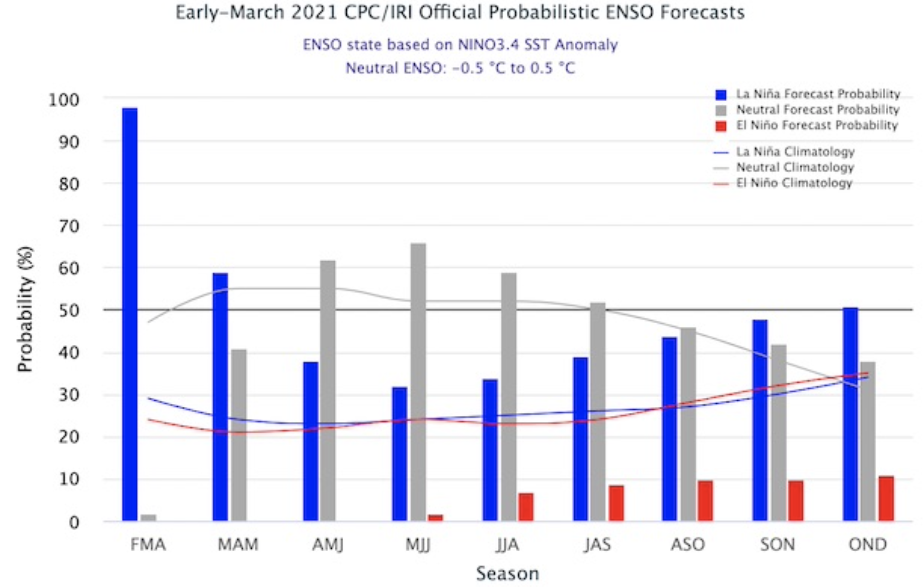
La Niña continues in the tropical Pacific, but it has weakened recently, and forecasters estimate about a 60% chance of a transition to neutral conditions in the late spring. Looking farther out into the fall of 2021, El Niño is unlikely to develop, and the chances of La Niña and neutral are similar.
Migratory birds
The February 2021 average sea surface temperature in the Niño3.4 region—our primary ENSO monitoring index—was just about the same as January, at about 1.0°C cooler than the 1991–2020 average, according to the ERSSTv5 dataset. (ICYMI: I covered the shift to the 1991–2020 average last month.) This comfortably exceeds the La Niña threshold of 0.5°C cooler than average.
Monthly sea surface temperature in the Niño 3.4 region of the tropical Pacific for 2020-21 (purple line) and all other years starting from first-year La Niña winters since 1950. Climate.gov graph based on ERSSTv5 temperature data.
Switching datasets so that we can see more recent activity, the weekly-updated OISST dataset shows an anomaly in the Niño3.4 index of about 0.7°C cooler than average last week. As Tom detailed in a post with my favorite title so far*, ERSSTv5 and OISST are different datasets with different methodologies, and they often show slightly different averages. OISST’s weekly updates can fluctuate and shouldn’t be used to judge things like how strong an ENSO event is. However, weekly updates, coupled with other observations, can give us an indication of what direction things are headed. In this case, signs are pointing to the Niño3.4 index moving closer to the long-term average.
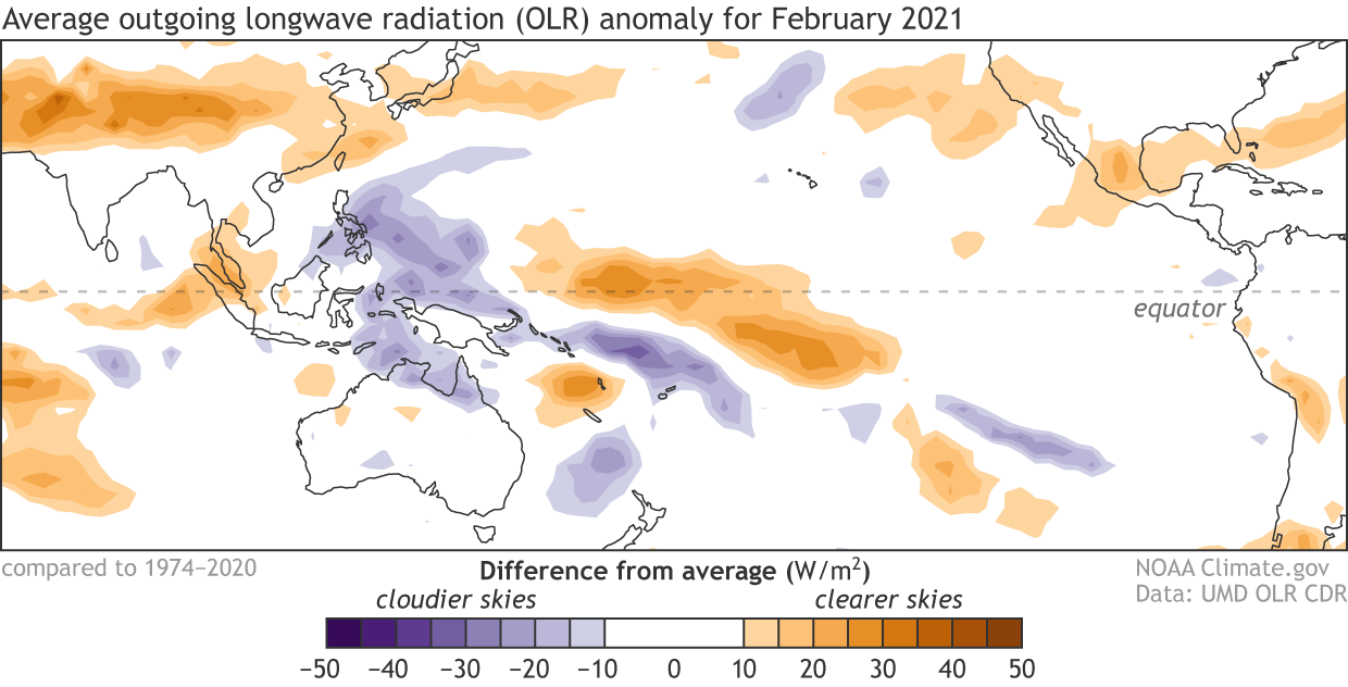
Speaking of other observations, atmospheric coupling (the atmospheric response to the changed sea surface temperatures, aka ENSO’s hallmark) weakened during February. The atmospheric pattern we expect during La Niña—less rain and clouds over the central Pacific and more over Indonesia—was still present, but reduced from earlier in the winter.
Outgoing long-wave radiation anomaly for February 2021. Regions with more clouds and rain than average are shown in purple; areas with fewer clouds and less rain are shown in orange. Climate.gov image from CPC data.
We keep a close eye on the temperature of the water under the surface of the tropical Pacific, because the subsurface (approximately the upper 1,000 feet of the ocean) functions as a supply for the surface. The amount of cooler-than-average subsurface water diminished over February, further indication that La Niña is likely to continue weakening.
Songbirds
Most of the computer models predict a transition to neutral by spring, and the weakening conditions in the tropical Pacific add confidence to those predictions. But what about later in the year? Long-range ENSO prediction is notoriously difficult this time of year, as we head into the spring predictability barrier. What is this barrier, you ask? In brief, computer model predictions made in the spring are less reliable than predictions made in other times of the year. There are a lot of things going on in the spring that make forecasting challenging, including that ENSO is often changing from one phase to another (e.g., from La Niña to neutral).
The spring barrier is contributing to the split in the forecast probabilities for later this year, with odds of about 40-45% for neutral and 45-50% for La Niña for the fall. Forecasters think El Niño is unlikely, with about a 10% chance of development by the early winter.
The official CPC/IRI ENSO probability forecast, based on a consensus of CPC and IRI forecasters. It is updated during the first half of the month, in association with the official CPC/IRI ENSO Diagnostic Discussion. It is based on observational and predictive information from early in the month and from the previous month. Image from IRI.
El Niño has only developed following a first-year La Niña twice in our historical record (1950–present), as you can see in the graph earlier in this post. We have a few months of spring barrier to go, but by June we may be able to get a clearer picture of how the rest of the year will look, ENSO-wise.
Waterfowl
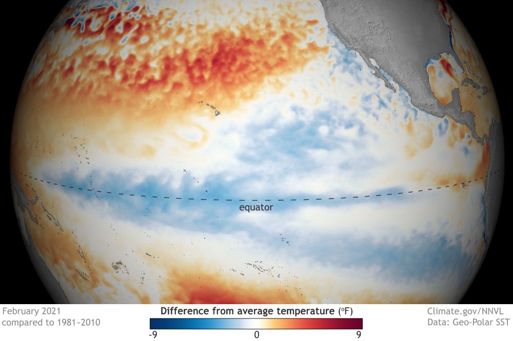
Overall, this La Niña has been an odd duck. It developed following a neutral winter—the first time in the historical record that has happened. Also, a “typical” La Niña sea surface temperature pattern is generally symmetric across the equator, with regions of cooler-than-average surface temperatures extending north and south toward Central America and South America. For most of the winter, this La Niña had a clear region of cooler surface waters in the eastern Pacific south of the equator, but lacked the mirrored signal north of the equator. This pattern did emerge somewhat during February, however.
February 2021 sea surface temperature departure from the 1981-2010 average. The cooler-than-average waters of La Niña are noticeable at the equator in the Pacific. Image from Data Snapshots on Climate.gov.
And, as Nat investigated last month, the jet stream pattern did not look very La Niña-y through much of the winter. This was despite the very clear La Niña patterns in the atmosphere and ocean across the tropical Pacific. One thing we can say with confidence is that La Niña 2020–21 will provide ENSO and climate researchers some interesting material.
Another thing we can say with confidence is that we’ll have our binoculars trained on the tropical Pacific so we can keep you updated on all things ENSO. And perhaps we’ll catch sight of a blue-footed booby, or a wandering albatross.