Rockfall destruction challenges green-power provider and the nonprofit, member-supported ice park as repair costs climb.
Workers arriving early at the Ouray Ice Park on Tuesday found a disaster.
A boulder the size of a pool table had sheared off the canyon wall and destroyed the metal walkway accessing the park’s popular ice climbs. And it ripped out the penstock that ferries water to the oldest operating hydropower plant in the U.S.
“Just water squirting everywhere and the access bridge, laying at the bottom of the canyon,” said Eric Jacobson, who owns the hydroelectric plant and pipeline that runs along the rim of the Uncompahgre River Gorge.
The rock tore through the penstock, its trestle and the decades-old steel walkway in the park’s popular Schoolroom area late Monday. There was no one in the gorge and no injuries.
When the overnight temperatures are cold enough in December, January and February, a team of ice farmers use as much as 200,000 gallons of water a night trickling from the penstock to create internationally renowned ice-climbing routes. More than 15,000 climbers flock to Ouray every winter to scale the 150-foot fangs of ice, supporting the city’s winter economy. And Jacobson generates about 4 million kilowatt hours a year from water flowing into his antiquated but updated Ouray Hydroelectric Power Plant. He sells the power to the San Miguel Power Association.
The plant generates about 5% of the association’s power needs, which has a robust collection of green power sources, including several small hydropower plants and a solar array in Paradox.
Click on a thumbnail graphic to view a gallery of drought data from the US Drought Monitor website.
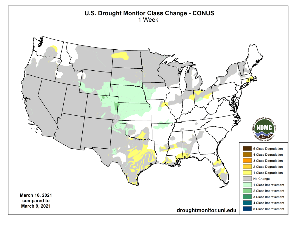
US Drought Monitor March 16, 2021.
West Drought Monitor March 16, 2021.
High Plains Drought Monitor March 16, 2021.
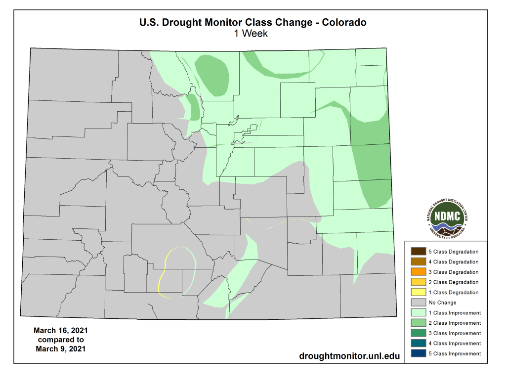
Colorado Drought Monitor March 16, 2021.
Click here to go to the US Drought Monitor website. Here’s an excerpt:
This Week’s Drought Summary
A vigorous and slow-moving area of mid-level low pressure tracked from the Four Corners region to the Central Great Plains from March 13 to 15. Widespread precipitation (rain and snow totaling 2 to 6 inches, liquid equivalent) fell across the Central Rockies, Central Great Plains, and Lower Missouri River Basin. Snowfall amounts ranged from 2 to 4 feet from Colorado north to Wyoming. However, across North Dakota, dry weather continued. As a low pressure system tracked eastward, rainfall (locally more than 2 inches) overspread the Ohio and Tennessee Valleys along with parts of the Southeast on March 14 and 15. Mostly dry weather prevailed along the East Coast from March 9 to 15. During this 7-day period, below normal precipitation was observed throughout much of the Pacific Northwest while precipitation amounts exceeded 2 inches (liquid equivalent) for the Sierra Nevada Mountains and coastal ranges of California. A low pressure system and trailing front resulted in heavy rainfall and flooding across parts of the Hawaiian Islands during early March…
US Drought Monitor one week change map for Colorado ending March 16, 2021.
A strong and slow-moving low pressure system brought widespread heavy precipitation (more than 2 inches, liquid equivalent) to northeast Colorado, southeast Wyoming, southwest South Dakota, northern Kansas, and much of Nebraska. Denver, Colorado received 27.1 inches of snowfall on March 13 and 14, making it the 4th largest snowfall on record. According to the storm summary from the Weather Prediction Center, other notable snowfall amounts included: 42” near Buckhorn Mountain, CO, 27” near Hot Springs, SD, and 19” near Gering, NE. The highest snowfall amount reported from this storm was 52.5” at Windy Peak, WY. The heavy snowfall brought snow water content close to average for mid-March across most of Colorado and Wyoming. This recent heavy precipitation also eliminated precipitation deficits and resulted in precipitation surpluses for the past 90 days for much of the central Plains. Therefore, a broad 1-category improvement was made for areas that received 1 inch or more of precipitation. Based on SPI values at various time scales, small areas of 2-category improvements were justified for the central Great Plains west to the central Rockies. Please note that the drought impact type was changed from SL (short and long-term) to L (long-term) drought only where the heaviest precipitation occurred, but where long-term indicators such as SPI support a continuation of D1+ long-term drought.
Based on 120-day SPI values, a 1-category improvement was made to parts of southwest Wyoming and bordering areas of southeast Idaho and northeast Utah. Farther to the north, the northern third of South Dakota and North Dakota missed out on the drought relief. During the past two weeks, widespread 1 to 2-category degradations were made and only slight changes were necessary this week. However, based on soil moisture below the 5th percentile and SPI values, D3 (extreme) drought was introduced to parts of North Dakota. If below normal precipitation persists later into the spring when temperatures warm, rapid intensification of drought conditions may occur..
Below normal precipitation prevailed across the Pacific Northwest during the past week. Recent dryness during the past 30 days and below normal 28-day average streamflows supported a northward expansion of abnormal dryness (D0) across eastern Washington. Near to above normal precipitation was generally observed throughout California, the Great Basin, and Desert Southwest during early to mid-March. As of March 16, snow water content is running 60 to 75 percent of average across the Sierra Nevada Mountains. No changes were made this week to much of the moderate (D1) to exceptional (D4) drought areas across the West…
As an intense mid-level low pressure system crossed the Four Corners Region, an early season severe weather outbreak occurred across the Texas Panhandle on March 13. According to the Storm Prediction Center, more than a dozen tornado reports were tallied. Along with the severe weather, locally more than 1 inch of rainfall was observed across the Texas Panhandle, resulting in drought improvement. This 1-category improvement extended east to parts of southwest Oklahoma where Oklahoma Mesonet gauges recorded 1 to 2.5 inches of rainfall this past week. Elsewhere across the southern Plains, western Gulf Coast, and lower Mississippi Valley, mostly dry weather prevailed along with above normal temperatures and periods of increased winds. Based on short-term indicators, abnormal dryness (D0) and drought (D1-D3) were expanded in coverage across south-central Oklahoma and Texas. Wheat is entering the critical hollow stem stage across south-central Oklahoma. The northeast quarter of Louisiana has received less than 4 inches of precipitation during the past 60 days which prompted a slight increase in the coverage of short-term moderate drought (D1). An increase in the coverage of D0 was made across parts of Louisiana and Mississippi, due to increasing short-term precipitation deficits along with soil moisture and 28-day streamflows below the 30th percentile…
Looking Ahead
During the next 5 days (March 18 to 22), a low pressure system is forecast to bring widespread precipitation (0.5 to 2 inches, locally more) to the Ohio and Tennessee Valleys and Mid-Atlantic. Farther to the south across the Florida Peninsula, dry weather is likely to persist. Little to no precipitation is also forecast for the Southwest and northern Great Plains. As a mid-level area of low pressure progresses inland from the East Pacific, rain and high-elevation snow are expected to overspread the Pacific Northwest, northern California, and the northern and central Rockies.
The CPC 6-10 day extended range outlook (valid from March 23 to 27) favors above normal precipitation throughout most of the central and eastern U.S. except for the Florida Peninsula, where probabilities for below normal precipitation are slightly elevated. Increased chances of above (below) normal precipitation are forecast for the Southwest (West Coast). Above normal precipitation is favored for Alaska. Above normal temperatures are likely from the Mississippi River to the East Coast, while below normal temperatures are favored for much of the western U.S. and Alaska.
US Drought Monitor one week change map ending March 16, 2021.
It appears drought contingency planning is officially underway for 2021 and 2022 throughout the Colorado River Basin, and water banking in conjunction with conservation and curtailments may be the way of the future. As a newly appointed Colorado River District board member, Kathleen Curry gave Gunnison County commissioners an update recently on the River District board meeting she attended in late January.
Among the biggest concerns, said Curry, are drought conditions that persist even on years with pretty good snowfall. “Even when the snowpack is decent, it’s not all getting down to the major reservoirs. Maybe it is soil moisture, maybe ambient temperatures, I’m not sure that we know exactly why. But the whole system will be under a drought release scenario and that does include Aspinall unit operations,” she said.
As of March 9, the Upper Gunnison Basin snowpack was 76 percent of average according to the Gunnison River Basin website. The spring (April through July) unregulated inflow volume to Blue Mesa Reservoir is forecast to be 68 percent of average. The website estimates that flows originating from the Gunnison River Basin historically contribute about 17 percent of the total flows in the Upper Colorado River Basin, accounting for water that approximately 6.8 million people annually rely upon.
Lake Powell may drop
Curry described Bureau of Reclamation projections that Lake Powell will release 8.23 million acre-feet to Lake Mead, with around 6 million acre-feet coming in and resulting in an overall decline in water storage.
“So we have to send that water down to Lake Mead, but the Bureau is projecting this declining hydrology to put us into some new drought contingency planning,” she explained. The contingency plan has now formally been triggered per 2007 agreements…
“In 2022, our releases [from Aspinall] will decrease from 8.23 to 7.48 million acre-feet, which is good, it gives us a little bit of relief. But still, those releases are higher than the inflows, most likely. Powell will continue to drop,” she predicted…
Demand management and water banking
The River District has kicked off a stakeholder advisory group on demand management, which is also being discussed at state levels.
“It’s the talk of the town. Everybody’s been thinking about it for a couple of years now,” said Curry. The idea is a voluntary, temporary and compensated water conservation program could put water aside in a 500,000 acre-foot storage pool in Lake Powell to help the state deal with Colorado River Compact compliance issues and shortages. “There are a couple pieces to this demand management discussion,” said Curry.
She said there are questions of funding, impacts, participation and whether there could be enough water generated to make a difference. Five participants from the Gunnison Basin have joined the group, and will give input to the Colorado Water Conservation Board in June or July.
A lot of water rights in the Gunnison Valley are junior to the compact, and both those and senior water rights could become a part of the dialogue. “So we have an interest, since we are an agricultural basin, in this issue,” said Curry.
County commissioner Liz Smith asked how water banking could benefit the communities doing the conservation, versus that water being drawn from downstream users in the past. Curry agreed that there had not in the past been a way to account for historic consumptive use and subsequent water savings, but there are methods being developed for logging and saving that water.
Curry also reviewed some conservation techniques for water banking, including curtailment programs where ranchers would fallow their land for either part of a season or an entire season.
Here’s the release from the Bureau of Reclamation (Peter Soeth):
The Bureau of Reclamation is awarding $42.4 million in grants to 55 projects throughout 13 states. These projects will improve the water reliability for these communities by using water more efficiently and power efficiency improvements that water supply reliability and generate more hydropower. The projects are anticipated to conserve more than 98,000 acre-feet of water per year.
“Improving water and energy efficiencies is one way Reclamation is using its resources to provide communities in the West the ability to be resilient to climate change, because conserving water is also saving energy,” said Bureau of Reclamation Deputy Commissioner Camille Calimlim Touton.
These grants support President Biden’s new Executive Order on Tackling the Climate Crisis at Home and Abroad. These grants will help increase resilience to the impacts of climate change and conserve water.
The selected projects are in Arizona, California, Colorado, Idaho, Kansas, Montana, Nebraska, New Mexico, Oregon, Texas, Utah, Washington and Wyoming. Projects include canal lining and piping to reduce seepage losses; installation of advanced metering, automated gates, and Supervisory Control and Data Acquisition systems to improve water management; and programs in urban areas to install residential water meters.
The Confederated Tribes and Bands of the Yakama Nation located in central Washington will receive $570,965 to convert more than 15,000 feet of earthen canals to PVC pipe. The project will improve water use efficiency and reliability through optimal flow rates, reduced leakages and operational losses. The project is expected to result in an annual water savings of 1,504 acre-feet remaining in the system supporting the other needs within the irrigation project.
The Greenfields Irrigation District in Teton County, Montana, will receive $1.9 million to replace a concrete drop structure with an 11-foot diameter penstock and turbine with a planned capacity of 2,400 kilowatts. The project is also expected to save 1,190 acre-feet of water currently lost to seepage. The water saved will remain in the Sun River, improving flows for fish and recreation.
In California, near the Arizona border, the Bard Water District will receive $1.1 million to complete a canal lining and piping project. The project is expected to result in annual water savings of 701 acre-feet, which will remain in the Colorado River system for other uses. Once completed, the project will also better position farmers to work with Natural Resources Conservation Service’s Environmental Quality Incentives Program to improve on-farm irrigation systems.
Some projects complement on-farm irrigation improvements that can be carried out with the assistance of the U.S. Department of Agriculture’s Natural Resources Conservation Service to accomplish coordinated water conservation improvements.
“Infrastructure modernization is critical to enable agricultural producers to make additional improvements on their land,” said Astor Boozer, Regional Conservationist for NRCS’s western operations. “Using EQIP-WaterSMART Initiative assistance to reduce water losses and use irrigation water efficiently allows farmers to complement WEEG funded projects and to conserve additional water for prolonged droughts.”
Colorado River Indian Tribes, 73-19L-1 Canal Lining Project
Reclamation Funding: $209,182 Total Project Cost: $443,229
From the 2018 Tribal Water Study, this graphic shows the location of the 29 federally-recognized tribes in the Colorado River Basin. Map credit: USBR
The Colorado River Indian Tribes, located in western Arizona, will line 3,985 feet of the currently earthen 73-19L-1 canal reach of the Colorado River Irrigation Project with a geosynthetic membrane covered with shotcrete. This stretch of the canal has been identified as having the most significant seepage rate of all 232 miles of canals in the Colorado River Irrigation Project. The project is anticipated to result in annual water savings of 267 acre-feet currently lost to seepage. This area of Arizona is vulnerable to drought, having experienced drought conditions for the past 19 years, and the Tribes rely on the Colorado River as their sole source of water. The water conserved through the project will be utilized by the Tribes primarily to meet demands on the Reservation, within the limits of their existing water rights…
City of Aspen, Aspen Maroon Creek Penstock Lining Project
Reclamation Funding: $480,232 Total Project Cost: $3,001,452
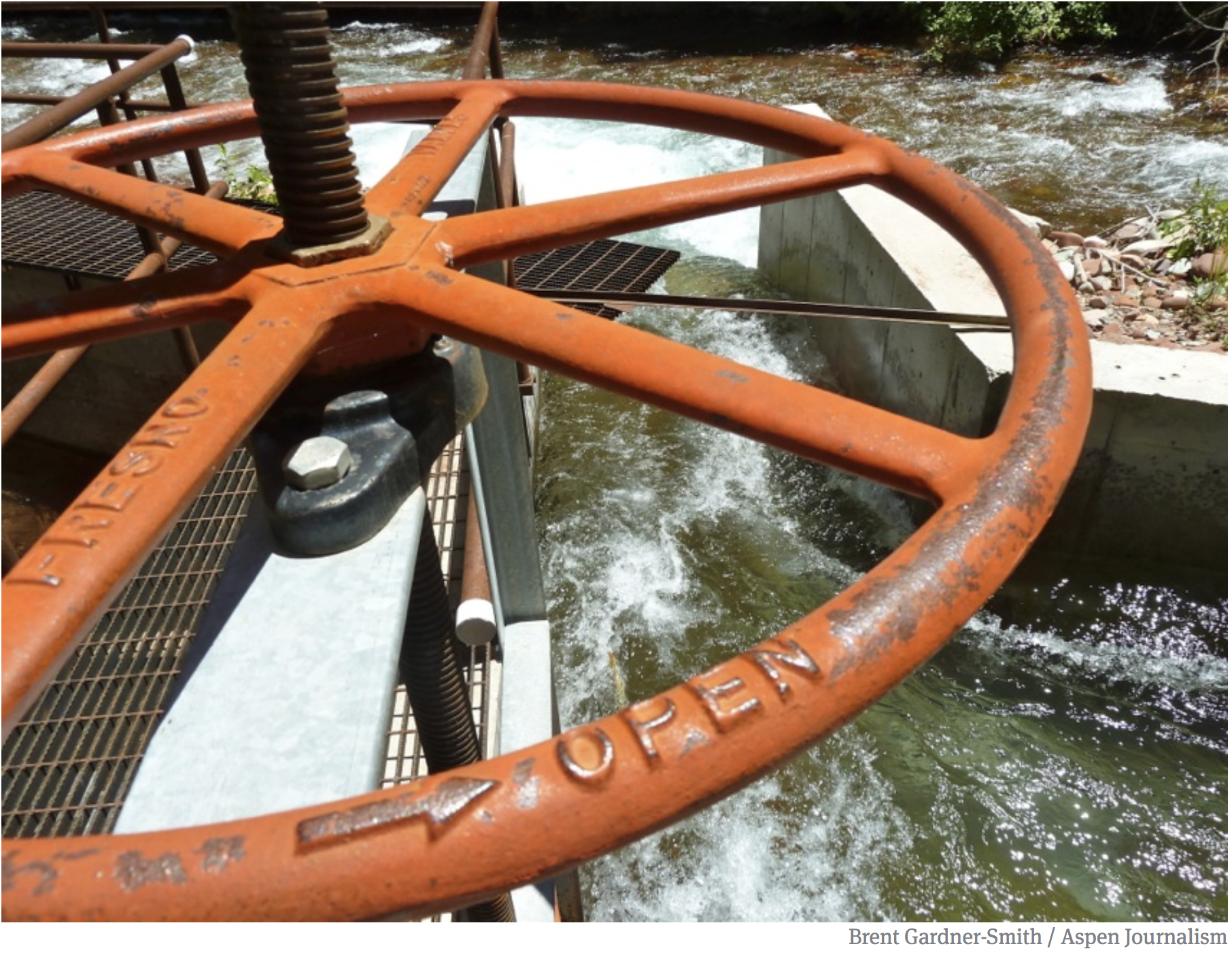
A headgate on an irrigation ditch on Maroon Creek, a tributary of the Roaring Fork River. Photo credit: Aspen Journalism/Brent Gardner-Smith
The City of Aspen will line approximately 6,235 feet of existing concrete pipe that carries water from Maroon Creek to its raw water storage reservoir and will also install a 400-kilowatt hydroelectric generation facility. The City does not currently have a large storage reservoir like most local water systems, and supplies are direct-flow water rights which are directly impacted by seasonal fluctuations and environmental conditions. The project will result in annual water savings of 360 acre-feet currently lost through the existing pipeline. Water savings will be used to meet existing municipal demands and to reduce diversions and allow for increased instream flows in Maroon Creek…
Nebraska Bostwick Irrigation District, Superior Canal Delivery Efficiency Improvement Project
Reclamation Funding: $2,000,000 Total Project Cost: $4,507,591
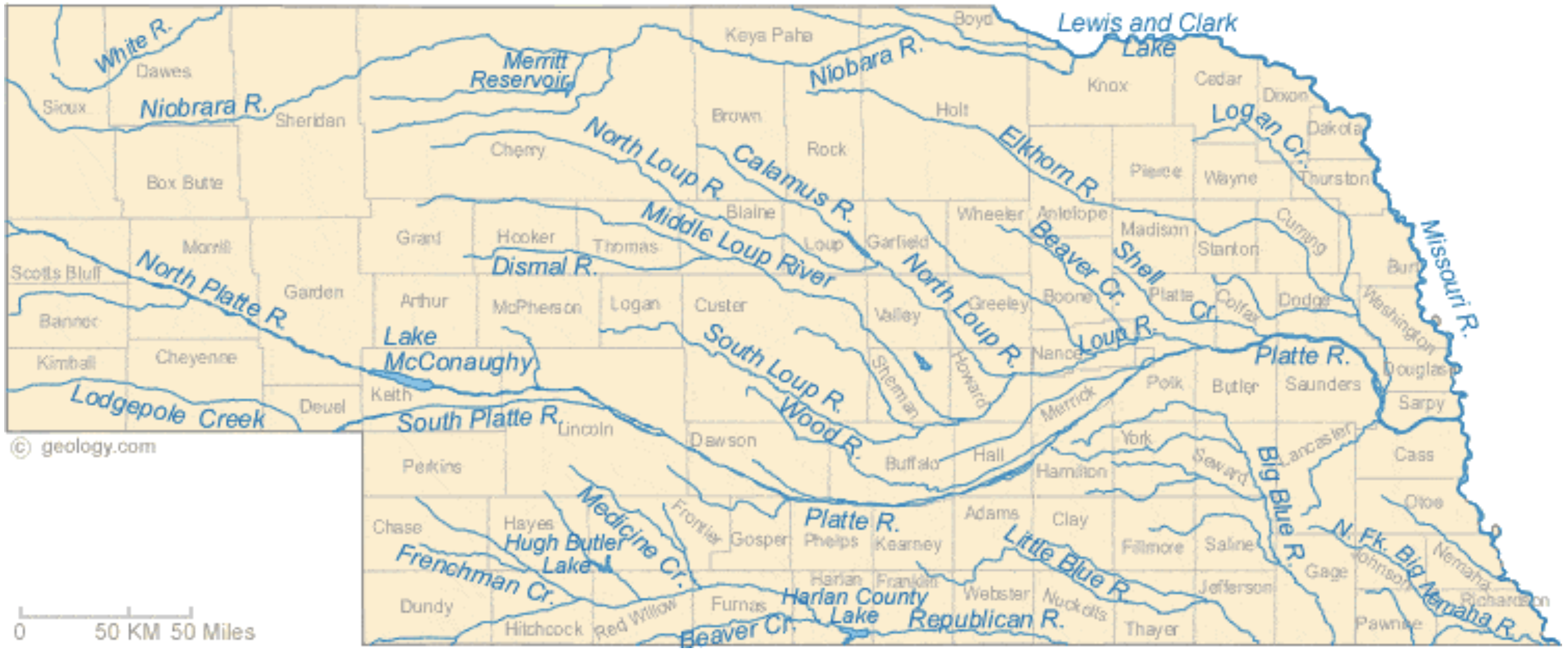
Nebraska Rivers Shown on the Map: Beaver Creek, Big Blue River, Calamus River, Dismal River, Elkhorn River, Frenchman Creek, Little Blue River, Lodgepole Creek, Logan Creek, Loup River, Medicine Creek, Middle Loup River, Missouri River, Niobrara River, North Fork Big Nemaha River, North Loup River, North Platte River, Platte River, Republican River, Shell Creek, South Loup River, South Platte River, White River and Wood River. Nebraska Lakes Shown on the Map: Harlan County Lake, Hugh Butler Lake, Lake McConaughy, Lewis and Clark Lake and Merritt Reservoir. Map credit: Geology.com
The Nebraska Bostwick Irrigation District, located in south-central Nebraska, will construct two new diversions for the lower Superior Canal. The District holds storage rights in Harlan Reservoir, approximately 50 miles upstream of the Superior Diversion structure. Currently, much larger than required volumes of water must be released from the reservoir to overcome canal losses incurred delivering water to the users at the end of canal, which results in end-of-canal spills. The District will install two gallery wells in the north bank of the Republican River to supply water to the lower portion of the Superior Canal instead of transporting these supplies through the entire length of the canal. The gallery wells will be linked to the District’s main office through automation for instantaneous control of the pumps to increase system efficiency. Once complete, the project is expected to result in annual water savings of 3,400 acre-feet that will remain in the Harlan Reservoir and be made available in times of shortage, thereby reducing the District’s diversions from the Republican River. The project builds on efforts to more effectively manage operations of Harlan County Reservoir and the overall water supplies of the basin, with the goal of improving the flexibility and reliability of Republican River Compact compliance activities for Nebraska, Kansas, Colorado, and the various federal and local water interests in the basin…
Bard Water District, Concrete Lining of the Acoma Lateral & Decommissioning of the Titsing Sub-Main with New Pipeline (Phase 4)
Reclamation Funding: $1,117,994 Total Project Cost: $2,235,988
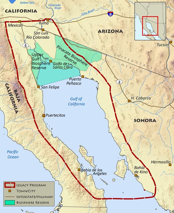
The Colorado River Delta via the Sonoran Institute
The Bard Water District, located in southern California near the Arizona border, will line 5,550 feet of the currently earthen Acoma Lateral with concrete and decommission the 2.5-mile Titsing Sub- Main to install a 36-inch diameter pipeline. The project is expected to result in annual water savings of 701 acre-feet, which is currently lost to seepage, evapotranspiration, and operational losses. Conserved water will remain in the Lower Colorado River System and can be used by other water users during drought years and in times of shortage, including the Quechan Indian Reservation. Once completed, the project will allow farmers to work with the Natural Resources Conservation Service’s Environmental Quality Incentives Program to improve irrigation systems.