A kayaker makes her way down the San Juan River, which delivers water from Colorado, New Mexico and Utah to Lake Powell. Photo credit: Brent Gardner-Smith/Aspen Journalism
From email from Reclamation (Susan Novak Behery):
In response to forecast warmer weather and increasing flows in the critical habitat reach, the Bureau of Reclamation has scheduled a decrease in the release from Navajo Dam from 700 cubic feet per second (cfs) to 600 cfs on Saturday, May 1st, starting at 0400 AM. Releases are made for the authorized purposes of the Navajo Unit, and to attempt to maintain a target base flow through the endangered fish critical habitat reach of the San Juan River (Farmington to Lake Powell).
The San Juan River Basin Recovery Implementation Program recommends a target base flow of between 500 cfs and 1,000 cfs through the critical habitat area. The target base flow is calculated as the weekly average of gaged flows throughout the critical habitat area from Farmington to Lake Powell.
How Colorado legislators propose to begin crimping methane emissions in the built environment
If methane were a guest at a dinner party in Colorado, it’d be noticing that the hosts have started checking their watches and begun to make comments about a busy schedule the next day.
SB 21-246 (Electric Utility Promote Beneficial Electrification), introduced last week by Senator Majority Leader Steve Fenberg, is the latest evidence from legislators that they want methane, the primary constituent of natural gas, to begin thinking about moving on. The bill is scheduled to get its first hearing Thursday afternoon at the Colorado Capitol.
Instead of burning natural gas and other fossil fuels in buildings to provide heat, warm water and for cooking, Fenberg’s bill would encourage use of electricity for those purposes. The process is being called beneficial electrification.
“Fossil gas and petroleum products will contribute to supplying Colorado’s energy needs for many years to come,” says the bill, submitted by Fenberg, a Democrat from Boulder. “Nonetheless, transitioning to clean electric homes and businesses is a critical strategy for improving public health and safety, saving energy, creating family-sustaining jobs, and helping the state meet its greenhouse gas emission-reduction targets.”
The bill is premised on the expectation of a complete reversal during the next decade in how Colorado’s utilities generate electricity. In 2020, coal and natural gas were responsible for 78% of electrical production in Colorado, according to the U.S. Energy Information Agency. By 2030, utilities responsible for nearly all of electrical sales expect to be at 80% renewables. Some aspire to even higher levels. Holy Cross Energy has adopted a 100% goal.
That language echoes the Colorado Decarbonization Roadmap that was issued in January by the state’s energy office. Buildings lag electrical generation and transportation among the leading sectors for greenhouse gas emissions, but they’re not far behind. Importantly, we don’t replace buildings every 10 or 15 years, the way we do cars. That’s why those working to reduce greenhouse gas emissions see need to begin work now on fuel switching in homes and other buildings.
The roadmap envisions electricity denting use of natural gas in the next 30 years. Coupled with electrification of transportation and population growth, the increased demand will cause demand for electricity to double, according to a study by the consulting firm E3 that was commissioned by the Colorado Energy Office.
Colorado’s attention to methane comes after a decade of growing concern about methane, both nationally and internationally. The New York Times on Sunday previewed what it called a “landmark United Nations report” that reflects a “growing recognition that the world needs to start reining in planet-warming emissions more rapidly, and that abating methane, a particularly potent greenhouse gas, will be critical in the short term.
While cutting back on carbon dioxide emissions will remain urgent, “it’s going to be next to impossible to remove enough carbon dioxide to get any real benefits for the climate in the first half of the century,” Drew Shindell, the study’s lead author and a professor of earth science at Duke University (and a consultant on efforts to abate methane from coal mines in Colorado’s North Fork Valley), told the newspaper.
“But if we can make a big enough cut in methane in the next decade, we’ll see public health benefits within the decade, and climate benefits within two decades,” Shindell said.
This is from Big Pivots, an e-journal covering the energy and water transitions in Colorado and beyond. To get copies, sign up at https://bigpivots.com
Fenberg’s bill is not nearly as ambitious as the coming UN report might suggest is needed. However, it’s bold in that it seeks to shift the direction by nudging gas utilities to offer more carrots to customers to nudge the shift along.
The primary lever for this shift would be adoption of a relatively new metric for evaluating the cost-effectiveness of demand-management programs, something called the social cost of methane. The new metric seeks to apply the real, long-term costs of greenhouse gas pollution to deliberations about utility programs.
In this it’s similar to the social cost of carbon, an attempt to evaluate the real costs of carbon dioxide pollution.
Methane pollution, though, has a much higher price that reflects its short-term heat-trapping properties, about 80 times as powerful over the course of the first two decades, after which it has mostly dissipated. The cost assigned is $1,746 per short ton. The social cost of carbon was set by statute in Colorado at $46. Both, however, are subject to inflation.
This house in Candelas, a development in Arvada, is among the 40,000 a year being constructed in Colorado, very nearly all of them connected to natural gas lines. Photo/Allen Best
Fenberg’s bill falls short of mandating fuel switching. The bill explicitly prohibits the PUC from requiring the removal of gas-fueled appliances or equipment from existing structures or banning the installation of gas service lines to new structures.
Instead, the bill intends for the PUC to push the utilities to offer attractive programs to customers such that they will voluntarily use electricity in new construction or replace gas fixtures such as furnaces and water heaters in existing homes and other buildings.
Several other bills also seek to tamp down emissions of methane and the combustion of natural gas.
Hansen, a Democrat from Denver, has a bill—now being reformulated—that calls for a renewable natural gas standard, somewhat similar to that adopted by Colorado voters in 2004 for electrical generation. The intent of SB21-161 (Voluntary Reduce Greenhouse Gas Natural Gas Utility) is to encourage natural gas utilities with 250,000 customers or more to capture methane from dairies, landfills, and existing and abandoned coal mines in order to meet greenhouse gas reduction targets.
HB 18-1286 (Energy Performance For Buildings) would require owners and managers of buildings larger than 50,000 square feet to benchmark energy use and comply with performance standards, tamping down greenhouse gas emissions.
Separately from the legislative agenda, both the Colorado Air Quality Control Commission and the Colorado Oil and Gas Conservation Commission have adopted regulations in the last year that seek to crimp emissions of methane during extraction and transmission.
The vast majority of those cuts will fall upon Pinal County farmers who have taken CAP instead of pumped groundwater for 35 years. CAP is the principal drinking water source for Tucson, but the first round of cuts will have no impacts on the city’s CAP supplies.
At a virtual briefing Thursday, the heads of the Arizona Department of Water Resources and the Central Arizona Project said they’ve known for many years that shortages will be coming and that they’ve stepped up with detailed plans for it.
They stressed the large amount of negotiation and other work that went into the drought plan. They discussed in detail how a large number of water providers, tribes and other entities offered both water supplies and money to provide relief to farmers and others whose water supplies will be cut.
Central Arizona farmers, due to lose 320,000 feet of CAP water in 2022, will get about 105,000 of that back in water supplies from other sources. They’ll also get money from a wide variety of sources to drill wells for another 70,000 acre- feet.
A group of Phoenix-area cities and several tribes, including the Tohono O’Odham west of Tucson, stand to lose 60 percent of a separate CAP pool called Non-Indian Agricultural water, because it used to belong to farmers. They’ll get 75 percent of that back through mitigation approved under the drought plan.
In response to questions Thursday, Central Arizona Project General Manager Ted Cooke and Arizona Department of Water Resources Director Tom Buschatzke said they see no reason to plan for additional cuts beyond what the drought plan envisions before that plan expires in 2026.
There’s no need to limit population growth to hold down demands for the state’s limited and shrinking water supplies, despite calls for that from some environmentalists, Cooke and Buschatzke also said Thursday…
The cuts are necessary because Lake Mead is forecast to fall to 1,067 feet by the end of 2021. Under the 2019 drought plan, CAP will takes that first major cut in deliveries if the U.S. Bureau of Reclamation predicts in August that Mead will fall below 1,075 feet in December.
At Thursday’s briefing, Dan Bunk, a Bureau of Reclamation official, laid out a series of grim statistics showing the decline in river flows and reservoir levels.
Today, Lake Mead is at 38 percent of its total capacity and Lake Powell is at 35 percent of capacity, said Bunk, of the bureau’s Lower Colorado River office in Boulder City, Nevada.
Lake Mead has dropped 15 to 16 feet since a year ago and Powell has dropped 35 feet in the same period, he said…
Snowpack levels peaked this year at 89 percent of median levels. Soil moisture is at near record low levels in the river’s Upper Basin, he said…
This year is on pace to be the river’s third or fourth driest runoff season in modern-day records, he said. The 22 years of drought the basin has had since 2000 represents the driest period on record even when looking at longer-term, tree ring and other paleo records dating back 1,000 years, he said.
Because of these forecasts, and because of continued bleak forecasts for the river in 2023, water researchers Kathryn Sorensen at Arizona State University and John Fleck at the University of New Mexico have said Arizona should start looking now at how to use less water or find alternative sources. Arizona and the other river basin states are gearing up for what’s looming as extremely complex, contentious negotiations for new guidelines for the river system starting in 2026.
Dry periods between rainstorms have become longer and annual rainfall has become more erratic across most of the western United States during the past 50 years, according to a study published by the U.S. Department of Agriculture’s Agricultural Research Service and the University of Arizona.
Against the backdrop of steadily warming temperatures and decreasing total yearly rainfall, rain has been falling in fewer and sometimes larger storms, with longer dry intervals between. Total yearly rainfall has decreased by an average of 0.4 inches over the last half century, while the longest dry period in each year increased from 20 to 32 days across the West, explained co-senior author Joel Biederman, a research hydrologist with the ARS Southwest Watershed Research Center in Tucson, Arizona.
“The greatest changes in drought length have taken place in the desert Southwest. The average dry period between storms in the 1970s was about 30 days; now that has grown to 45 days,” Biederman said.
Extreme droughts are also occurring more often in the majority of the West according to historical weather data as there has been an increase in the year-to-year variation of both total rainfall amounts and the duration of dry periods.
The time between rainfalls has become longer and the rains occurred more erratically in the Southwest during the last 50 years. Photo credit: The Mountain Town News/Allen Best
The time between rainfalls has become longer and the rains occurred more erratically in the Southwest during the last 50 years.
Biederman emphasized the growing fluctuations in drought and rain patterns as the most significant change.
“Consistency of rainfall, or the lack of it, is often more important than the total amount of rain when it comes to forage continuing to grow for livestock and wildlife, for dryland farmers to produce crops, and for the mitigation of wildfire risks,” Biederman said.
The rate of increasing variability of rainfall within each year and between years also appears to be accelerating, with greater portions of the West showing longer drought intervals since 2000 compared to previous years.
Notable exceptions to these drought patterns were seen in Washington, Oregon and Idaho and the Northern Plains region of Montana, Wyoming, and the most western parts of North and South Dakota. In these regions, the researchers found some increases in total annual rainfall and decreases in drought intervals. Together, these changes support what models have predicted as a consequence of climate change: a northward shift in the mid-latitude jet stream, which brings moisture from the Pacific Ocean to the western United States, according to Biederman.
A critical aspect of this study is the use of actual rainfall data from 337 weather stations spread across the western United States. Biederman contrasted this with the more common use of “gridded” data, which relies on interpolations between reporting stations and tends to smooth out some of the variability revealed by this work.
“Fangyue Zhang, lead author of the manuscript and a post-doctoral researcher on our team, did the hard, painstaking work of compiling and analyzing data from more than 300 weather stations with complete daily records to reveal these changing drought and rainfall patterns,” Biederman said.
“We were surprised to find widespread changes in precipitation have already occurred across large regions of the West. For regions such as the desert Southwest, where changes clearly indicate a trend towards longer, more erratic droughts, research is urgently needed to help mitigate detrimental impacts on ecosystem carbon uptake, forage availability, wildfire activity, and water availability for people,” said co-senior author William K. Smith, assistant professor, University of Arizona.
The Agricultural Research Service is the U.S. Department of Agriculture’s chief scientific in-house research agency. Daily, ARS focuses on solutions to agricultural problems affecting America. Each dollar invested in agricultural research results in $20 of economic impact.
Confluence of the Little Colorado River and the Colorado River. Climate change is affecting western streams by diminishing snowpack and accelerating evaporation, a new study finds. Photo credit: DMY at Hebrew Wikipedia [Public domain]
A panel of judges yesterday revived a critical bid from the Navajo Nation to force the federal government to meet its treaty obligations and address the tribe’s well-documented water woes.
The decision from the 9th U.S. Circuit Court of Appeals could have far-reaching implications as the federal government, states and tribes begin renegotiating Colorado River water allocations while the waterway’s basin suffers through a relentless drought.
The Navajo Nation sued federal regulators in 2003, arguing that the government’s operations guidelines for the Colorado River didn’t consider the tribe’s water rights or the amount needed to meet the government’s treaty obligations to the reservation.
A federal district court dismissed the claim, but the 9th Circuit disagreed. The appeals court found that the Navajo Nation has major water problems, and Judge Ronald Gould raised questions about whether the government is fulfilling its treaty with the tribe.
“Water is essential to life on earth,” Gould wrote. He later added: “[I]n the specific case of the Navajo Nation, news report have indicated that the Nation’s shortage of water have in part caused exacerbation of the risks from COVID-19.”
[…]
Despite being filed nearly 20 years ago, the case is in many ways still in its early phases. At issue before the 9th Circuit was the lower court’s dismissal of the tribe’s “breach of trust” claim.
Gould and the 9th Circuit found that the tribe had sufficiently brought that charge, and it should be considered. The 9th Circuit sent the case back to the lower bench.
“[T]he district court,” Gould wrote, “only had to consider whether the Nation needs water to fulfill the promise of establishing a Navajo Reservation as a homeland for the Nation’s people.”
Ripple effects
The case is likely to send shock waves through the seven-state Colorado River Basin.
Those states, the Interior Department and the 30 federally recognized tribes within the basin are about to begin negotiating new operations guidelines for the Colorado River that will determine each state’s allocations.
The negotiations are expected to be contentious because there is less water to go around, due to drought and climate change. Arizona, for example, said yesterday that it is prepared to lose about a fifth of the water it receives from the river in the coming year because a shortage is expected to be declared.
Click through to read the full interview with Peter Gleick that’s running in The Guardian (Maanvi Singh). Here’s an excerpt:
Peter Gleick argues there’s an urgent need to reshape our relationship to water: ‘There is enormous untapped potential for conservation’
California is once again in a drought, just four years after the last dry spell decimated ecosystems, fueled megafires and left many rural communities without well water.
Droughts are a natural part of the landscape in the American west, and the region has in many ways been shaped by its history of drought. But the climate scientist Peter Gleick argues that the droughts California is facing now are different than the ones that have historically cycled through the Golden State.
“These are not accidental, strange dry periods,” said Gleick, the co-founder of the Pacific Institute, a global thinktank that has become a leading voice on water issues in California and around the world. “They’re increasingly the norm.”
It’s dawn on a Friday, and the small team of experts is making its way from Globeville Landing Park down to the South Platte River to count birds. Yes, the watershed is girded by a massive sewer pipe, garbage, railroad tracks and highways. Yes, cranes and construction crews loom over the water.
And yes, it still teems with life.
This once-neglected stretch of the river’s ecosystem was the reason for their visit, which formally kicked off the third-annual South Platte BioBlitz. It’s a regular count of all kinds of wildlife that thrive where the Platte passes the National Western Center, a massive construction project that’s turning historic stockyards and this isolated stretch of river into a center of commerce and culture.
“Here we’re just tying to measure the impact of the construction and the improvement of the Western Stock Show Complex,” Azua told us. “Obviously urbanization has impacts on wildlife, and we’re just trying to monitor over several years to see what happens.”
While Azua was hesitant to make any predictions, there was a general sense among the group that the project will first disrupt the habitat nearby and then, slowly, create conditions for a better quality of life. But they won’t know without data. So for now, they count…
“(The river) was doing better than we thought,” he said. “Some of the species that are indicators of better quality habitat, like the dragon flies, were here. So that was a very pleasant surprise indeed.”
[…]
Water quality in this bend of the river is not much different than other parts of town. Jon Novick, who oversees the city’s water monitoring program, told us most chemicals and metals on his radar don’t show up in higher concentrations here, even though it is the most-downstream segment in the city…
“We need a few more years as we progress with the restoration,” Reading said. “My guess is, and my hope is, we’ll see a big increase in pollinators.”
Click on a thumbnail graphic below to view a gallery of drought data from the US Drought Monitor.
US Drought Monitor April 27, 2021.
West Drought Monitor April 27, 2021.
High Plains Drought Monitor April 27, 2021.
Colorado Drought Monitor April 27, 2021.
Click here to go to the US Drought Monitor website. Here’s an excerpt:
This Week’s Drought Summary
Several upper-level troughs and closed lows moved in the westerly jet stream flow across the contiguous U.S. (CONUS) during this U.S. Drought Monitor (USDM) week. They dragged surface fronts and low pressure systems along with them. The weather systems moved across the West then generally followed two storm tracks after crossing the Rockies – one track was along the Canadian border, while the other track was along the Gulf Coast states. As a result, above-normal precipitation fell across parts of the West, much of the Gulf Coast from eastern Texas and Oklahoma to Georgia, parts of the Mid-Mississippi Valley, and parts of the northern Great Lakes and Maine. Precipitation amounts were generally 0.5-2.0 inches in the West where precipitation fell, but exceeded 2 inches across a large part of the Gulf Coast states. The rest of the CONUS had below-normal precipitation for the week. A swath from New Mexico to Lower Michigan, and parts of the northern Plains and Far West, had little to no precipitation. With upper-level troughs and surface cold fronts dominating the circulation pattern, weekly temperatures averaged below normal across most of the CONUS. Drought or abnormal dryness contracted in parts of the southern Plains to Southeast, where heavy rains fell, and in parts of the northern Plains and Northeast, where overall conditions warranted improvement. But drought or abnormal dryness expanded or intensified across parts of the West, Midwest, other parts of the Plains, and the Carolinas, as well as much of Hawaii and Puerto Rico. In these areas, precipitation deficits grew and soils continued to dry. These changing conditions were reflected in several drought indices and indicators, including the Standardized Precipitation Index (SPI), streamflow and groundwater levels, soil moisture measurements on the ground and from satellite as well as soil moisture models, vegetation-based indices such as VegDRI, and mountain snow water content (SWE) in the West…
There were patches of 0.5-1.0 inch of precipitation in southeast Kansas, the Dakotas, Wyoming, Colorado, and the western half of Montana this week. But most of the region was dry, with less than 0.25 inch of precipitation falling. With improving conditions in the short-term (last 1-6 months), D0-D2 were pulled back in parts of South Dakota and northeastern Wyoming. But D4 expanded in northwest Colorado, and D3 expanded in eastern North Dakota where this week was dry and 6-9-month SPI are D3-D4, deeper soils are bone dry, streams are low, and stock ponds are dry or almost empty. D1-D3 expanded in northern Montana, D0-D2 expanded in western Wyoming, and D0 expanded in southwest Kansas. In the Montana Highline, reports were received from Blaine and Hill Counties of low soil moisture and stockwater ponds failing to fill. Three dozen reports were received from North Dakota, through the Condition Monitoring Observer system, of drying ponds and creeks, hay and feed shortages, and fire risk. USDA statistics rate more than half of the topsoil short or very short of moisture in Colorado (57%), Montana (57%), and Wyoming (55%), and nearly two-thirds or more so rated in South Dakota (62%) and North Dakota (80%); 32% of the winter wheat crop in Colorado was rated in poor to very poor condition. Several Colorado communities were asked to voluntarily conserve water…
Precipitation amounts from the Pacific weather systems that moved across the West this week were patchy and not enough to erase months of deficits. Half an inch to locally 2 inches fell across coastal areas and coastal ranges of Oregon, Washington, and northern California; in the Sierra Nevada; northern and central Rockies; and Great Basin ranges. Rainshadow areas and valleys, and much of the Southwest, received little to no precipitation. There were minor contractions of D4 in New Mexico and D0 in Idaho, but worsening dry conditions prompted expansion of drought and abnormal dryness in several western states. D1-D3 expanded along the northern California coast, D0-D2 expanded in the Pacific Northwest, and D3 expanded in western New Mexico. In California, the Marin Municipal Water District board unanimously approved mandatory restrictions for its 195,000 customers in south and central Marin County which would take effect on May 1. The goal was to curb overall district-wide water use by 40%. The potential for water shortages in Marin County was so high that the Marin Municipal Water District was talking with East Bay officials about building a pipeline across the Richmond-San Rafael Bridge to bring water into the county if the upcoming winter is similarly dry as the past two. Such a measure was used during the 1976-77 drought. Record low reservoir levels contributed to California Governor Gavin Newsom proclaiming a regional drought emergency for the Russian River watershed in Sonoma and Mendocino counties. A super bloom of lupine covered parts of the Folsom Lake lakebed in the Beeks Bight nature area in Granite Bay as historically low rainfall left the lake unusually low. Folsom Lake is at 37% of capacity and 50% of the historical average for April 27, according to the California Department of Water Resources Data Exchange Center. Shallow wells were going dry in the San Joaquin Valley, while Tulare County ranchers were culling cattle for sale months earlier than usual and were considering idling row crops to leave water for higher-value permanent crops like nut trees. The prolonged drought is causing significant die-offs of juniper trees in large areas of central and northern Arizona, according to Forest Service officials. Between 50,000 acres and 100,000 acres of junipers were affected in areas of the Prescott and Kaibab national forests between Paulden and Ash Fork and north of Williams. The cause of death appeared to be water stress, although some insects were observed. Die-offs ranged from 5% to 30% of the tree population, with some pockets of dead junipers up to 15 acres. USDA statistics showed increases in the percentage topsoil moisture short or very short – up to 89% in New Mexico, 70% in California, 69% in Oregon, 61% in Washington, 50% in Utah, and 32% in Idaho. According to media reports, the Biden-Harris administration announced the formation of an Interagency Working Group to address worsening drought conditions in the West and support farmers, Tribes, and communities impacted by ongoing water shortages. The Working Group will be co-chaired by the Departments of the Interior and Agriculture to build upon existing resources to help coordinate across the federal government, working in partnership with state, local, and Tribal governments to address the needs of communities suffering from drought-related impacts. The Working Group will work to identify immediate financial and technical assistance for impacted irrigators and Tribes…
In the southern Plains, the western half of Texas and Oklahoma were dry this week, with little to no rain falling. But a half inch or more of rain was widespread across the rest of the South, with 2+ inches in streaks across eastern Oklahoma and Texas, Arkansas and Louisiana, and southern Mississippi. D0-D3 contracted in eastern Texas, D0-D2 contracted in parts of Oklahoma, D1 disappeared and D0 contracted in Louisiana. But further west, D0-D4 expanded in southern and southwest Texas and D0 expanded in western Oklahoma. Dry or very dry soils grew in area to 67% of Texas and 29% of Oklahoma, according to USDA statistics, and 43% of the winter wheat crop in Texas was in poor to very poor condition. In the Midland-Odessa, Texas, area, 2020-2021 had the driest 13-month April-April period on record, and the fourth driest any 13-month period ever (behind 2011 which had the top 3 driest 13-month periods). Falling levels of the Edwards Aquifer triggered water restrictions in several Texas communities, including San Antonio, New Braunfels, and San Marcos…
Looking Ahead
A large low pressure trough moving out of the Southwest triggered areas of rain across parts of the southern and central Plains into the Midwest, and another system spread precipitation across the Northeast, as the new USDM week began. During April 29-May 3, another Pacific system will move into the country. These weather systems are forecast to spread an inch or more of precipitation across the southern Plains, Lower to Mid-Mississippi Valley, Tennessee and Ohio Valleys, southern Great Lakes, and Northeast. Bands of heavy precipitation – 3 inches or more – are expected across Texas to Arkansas and along the Ohio River. An inch or more of precipitation is projected to fall across parts of northeast Colorado, Wyoming, and northwest Washington. Half an inch or less of precipitation should fall across the Southeast from Florida to Virginia, New Mexico to the central Plains, the rest of the Great Lakes, and central to northern Rockies. No precipitation is forecast to fall over much of the northern Plains and most of the rest of the West. Temperatures are predicted to be near to above normal for the week across the CONUS. The outlook for May 4-8 shows drier-than-normal weather is favored for much of the West to Great Plains with wetter-than-normal conditions for most of the Mississippi River to East Coast region. Warmer-than-normal weather is likely across most of the western, southern, and East Coast states, except for the Mid- to Upper-Mississippi Valley, Great Lakes, and New England. Odds favor wetter-than-normal weather for southern Alaska and cooler-than normal weather for most of the state.
US Drought Monitor one week change map ending April 27, 2021.
The U.S. Drought Monitor from April 20th showed slight improvements in areas near Larimer and Boulder counties. Similar to last month, exceptional (D4) drought currently covers 15% of the state; extreme (D3) drought covers 17%; severe (D2) drought covers 28%; moderate (D1) drought covers 29%; and recent precipitation resulted in patches of abnormally dry (D0) areas in 10% of the state.
Colorado Drought Monitor April 27, 2021.
The 90-day Standardized Precipitation Index (SPI) values from Jan. 11 to Apr. 11 highlight continued dry conditions on the western slope. North eastern Colorado’s SPI data points reflect areas of above average precipitation after January and March snowstorms. The 12-month SPI map depicts the long-term drought conditions due to precipitation deficits in 2020 across the state, especially in the west.
The NOAA Climate Prediction Center three month outlook indicates increased chance of above normal temperatures and below normal precipitation are in the upcoming months. These forecasts are consistent with long-term temperature trends, and a strong signal in seasonal models of inordinate high pressure ridging over the West. Monsoon season remains uncertain. The current La Niña pattern continues to weaken and is expected to revert to neutral conditions in the summer. This is typical; ENSO signals are often dampened in summer. Development of a 2nd La Niña year is anticipated this fall through winter. The last two 2nd year La Niña events were water years 2012 and 2018. Both were drought years.
Water providers across the state report average to slightly below average storage levels and near normal demands. Drought management planning and potential restrictions are being discussed through multiple coordination groups. Stakeholders can follow along with state drought response actions and activities through public engagement pages for the Municipal Water Task Force and Agricultural Impact Task Force.
Colorado Public Safety presented an overview of the wildfire outlook for the coming year to the Water Availability Task Force. Many factors contribute to the extremity of a fire season including humidity, lightning or human created ignitions, rainfall during monsoon season, and winds. In the past, Colorado’s fire season began in late May through June into late August and September. More recently, this pattern has changed around the state and fires can occur during any month. The number of fires has been decreasing across the nation, but the number of acres covered by fires has increased. In 2020, 4 of the 20 largest fires in Colorado occurred, including the first, second and third largest fires in the state’s history.
Snowpack has already peaked, and remains below average
Snowmelt season is in full swing, but one may not know that by looking at the Animas River, which this week more closely resembles a slow trickle through Durango than a roaring, muddy torrent more common for this time of year.
The river’s flow Monday was about 328 cubic feet per second, according to the U.S. Geological Survey. By comparison, the average flow for April 26, based on 109 years of data, is 1,180 cfs. For reference, 1 cfs equals about 7.5 gallons flowing by a particular point in one second.
The Animas River’s peak runoff is still to come, but on average, the river’s flow is expected to be lower than usual through July, according to the National Weather Service. In fact, the river is expected to see about 45% of the volume it normally sees between April and July, said Aldis Strautins, National Weather Service hydrologist…
There are multiple reasons why the river is lower than average and projected to stay that way, Strautins said.
First, the region is in drought. Almost all of La Plata County was categorized as “extreme” or “exceptional” drought as of April 22, according to the U.S. Drought Monitor. Those are the most severe of five drought rankings.
Below-average precipitation and a poor monsoon season contributed to a dry summer and fall for Southwest Colorado, Strautins said.
Dry conditions led to low soil moistures. What precipitation the region did receive was immediately absorbed into the soil instead of running off.
As of Tuesday, the snowpack was at 57% of the basin’s average. It also peaked earlier than usual, March 28 instead of April 6, according to provisional Snotel data from the U.S. Department of Agriculture.
The snowpack started melting after a warm spell in early April, then the melt slowed because of winter storms and some cloudy, cool days.
Farmers expected to receive just a fraction of normal supply
Runoff from below-average snowpack is forecast to result in the lowest project irrigation supply in McPhee Reservoir history.
According to most probable forecast, Dolores River Basin snowmelt is expected to deliver 95,000 acre-feet of water to McPhee Reservoir, just 32% of the average 295,000 acre-feet average, reports the Colorado River Basin Forecast Center. The forecast could also continue to drop.
Full-service farmers of the Dolores Project are expected to receive just 1 inch per acre of irrigation water, or 4.5% of the 22 inches per acre provided when the reservoir fills, reports Ken Curtis, general manager for the Dolores Water Conservancy District that manages McPhee.
The forecast of 1 inch per acre is “the wost ever” for the Dolores Project, he said. The reservoir first filled in the late 1980s.
The previous worst irrigation seasons for McPhee Reservoir were in 2013 and 2002, when farmers received 6 inches per acre.
The amount of water predicted for this year is not enough for even one normal crop of alfalfa. With a full supply farmers typically get three to four crops of alfalfa per year. Farmers will be forced to consolidate crops into smaller acreage to produce anything on the limited water.
This year’s forecast shows McPhee Reservoir will fill less than 40% of its 229,000 acre-feet active capacity, according to forecast models. The reservoir had no significant carryover supply from last year’s water season.
Water shortages are across the board, except for domestic supplies for municipalities.
Ute Farm and Ranch on the Ute Mountain Ute Reservation is predicted to receive about 2,000 acre-feet, or 8.5% of the 23,300 acre-feet delivered when the reservoir has a full supply.
The water supply for downstream fish habitat dropped to less than 5,000 acre-feet of the 32,000 acre-feet provided when the reservoir fills.
Ashley Nielson, a senior hydrologist with the Colorado River Basin Forecast Center, said snowpack in the Dolores Basin took hits from multiple angles.
With the exception of a few good snowstorms, the basin experienced an extended dry period since April 2020, she said.
No monsoonal precipitation last summer dried out soils, which will cause snowmelt to be absorbed into the ground before it hits the river and McPhee.
Below-normal snowpack further suffered from warm weather and high winds in April, plus dust on snow that sped up evaporation.
April precipitation at the Lizard Head Pass Snotel is below normal, showing 0.2 inches, or 15% of the average 1.4 inches for the month…
On March 29, the Dolores Basin snowpack showed 83% of average for snow-water equivalent. On April 19, snowpack water equivalent had dropped to 32%.
As the county enters the second consecutive year of less water in a drying trend stretching back two decades, irrigators across New Mexico are struggling to keep orchards, pastures, farms and gardens alive.
The Upper Río Grande water basin that encompasses Taos County from the southern Colorado border south to Santa Fe, has three-fourths of the median usual snowpack as calculated over the last 30 years. The Río Grande in Colorado from the headwaters to the border is doing better at 110 percent of the median while the Jemez and Pecos basins had 64 and 52 percent of the median snowpack respectively.
The basin outlook and water supply forecast report, released monthly by the Natural Resources Conservation Service from January to May, estimates the amount of surface water that will be available through July – information critical to farmers, river guides and municipal water managers.
This year, the mountain snowpack in the Sangre de Cristos isn’t terrible, but the usual runoff of snowmelt that feeds river and flows into irrigation ditches hasn’t appeared.
Some irrigators think that’s because 2020 was dry enough that now the thirsty soil is sucking up all the water from the melting snow before the flow makes it far.
The U.S. Drought Monitor, produced weekly with data compiled about precipitation, soil and vegetation conditions, noted in early April that ‘due to a very limited monsoon season (in 2020) and sparse fall and winter snows, drought conditions have persisted across New Mexico. Severe to Exceptional conditions continue across the majority of the state.”
Judy Torres, director of the Taos Valley Acequia Association, said she recently went on a tour of the Río Chiquito in Talpa. “The mayordomo (ditch boss) said it usually takes 48 hours to go from the mountain to Río en Medio,” she said. “This time it took 10 days and the water still didn’t make it all the way. The ground is just so dry.”
[…]
Toby Martínez with the Jarosa Ditch in Ranchos de Taos said he sees good snowpack in the mountains that feed into the Río Grande del Rancho from which the acequia draws water. The wind over the last few weeks isn’t good, but the low temperatures have kept the snowpack in place, he said. “The mayordomos are keeping their fingers crossed and hoping we will still get flow,” Martínez said…
The next water supply forecast will be released in early May and is available at http://nrcs.usda.gov. The Drought Monitor map is published every Thursday and is available online at http://droughtmonitor.unl.edu.
Despite his outward enthusiasm, Peter Van De Carr admits he is preparing for the worst as he looks over SNOTEL data collected by the National Resource Conservation Service that shows snowpack in the Yampa and White river basins is about 80% of normal.
“You know if things turned around, and we started getting wetter than average kind of system coming in, it might turn around, “ Van De Carr said. ”We should be seeing rafts and kayaks, but it’s not worth going right now.”
Kelly Romero-Heaney, water resources manager for the city of Steamboat Springs, agrees the river flow is eye opening for this time of year.
“I’m surprised at how low the river is right now,” Romero-Heaney said. “I think it’s an indication that there is not a lot of snow remaining in the valley, because it melted off so quickly. I believe it got soaked up by the ground, because the soil was already so dry after last year.”
Van De Carr, who has owned Backdoor Sports for more than 30 years, said most years, the Yampa River peaks twice. First, when the snow in the lower valley melts fueling the Yampa’s spring flow and then again as the snow from the higher peaks melts and makes its way into the river below.
“We usually have this valley runoff surge, and the river will come up to 1,000 CFS (cubic feet per second). Then it’ll start going down, and everybody thinks its peaked,” Van De Carr said. “It does not peak until there’s almost no snow left on Mount Werner.”
But this year, that valley surge wasn’t as strong, and like Romero-Heaney, Van De Carr believes most of that moisture soaked into the dry ground before reaching the river…
Unfortunately, for Backdoor Sports and many other businesses that rely on the river to generate cash flow the outlook for this summer is challenging…
Hall said not having the river will hurt traffic on Yampa Street and his retail business, which rents paddleboards and gear…
Johnny Spillane, owner of Steamboat Flyfisher, said while the snowpack is important, the most vital thing for his business is getting moisture in the spring and summer…
Hall is also hoping the Yampa River Fund, which has been used in the past to purchase stored water, will be used to bring water into the Yampa later in the season if the valley doesn’t see wet, cool spring weather.
Colorado’s water storage reservoirs, struggling after two years of severe drought, are holding just 86 percent of their average supplies for this time of year, down dramatically from last year’s 107-percent-of-average mark.
The South Platte Basin, home to the metro Denver area, has been blessed with heavy spring snows and its reservoirs are the fullest in the state, measuring 99 percent of average at the end of March, the latest data available from the U.S. Natural Resources Conservation Service.
But the rest of the state’s storage pools are dangerously low.
And it is the state’s farmers who are suffering the most due to last summer’s ultra-dry weather and a weak winter mountain snowpack. Hardest hit is the southwestern corner of the state, where the San Juan/Dolores River Basin’s reservoirs stand at just 59 percent of average, a dramatic drop from last year, when those storage pools were at 104 percent of average, according to the NRCS.
Colorado reservoir storage March 31, 2021 via the NRCS.
“It’s terrible,” said Don Schwindt, a grower near Dolores who sits on the Southwestern Water Conservation District Board as well as the board of the Family Farm Alliance.
“We emptied virtually all of our [local] reservoirs last year,” he said, which means that there is little water to start the irrigation season if the spring runoff fails to deliver.
Schwindt said growers in his region were already worried last fall after the summer monsoon rains failed to arrive. Those rains are key to adding moisture to the soil ahead of winter, and when they don’t come, the dry soil under the snow absorbs much of the spring runoff.
In the Upper Rio Grande Basin, conditions are similarly dire, with growers preparing to reduce the number of acres they plant as the water forecast deteriorates.
“On our family farm we will have to cut back half of our plantings if we don’t start getting runoff,” said Kit Caldon, an ag producer in the Upper Rio Grande Basin. “There is no way we will plant everything we have even if we have a great runoff because our reservoirs are so low.”
Colorado, like other Western states, remains mired in a drought cycle that has seen four major droughts in the past two decades. The dry weather has sapped soils, raised wildfire danger, and drained underground aquifers on which farmers also rely.
Kathleen Curry is a former lawmaker, a lobbyist and a rancher in the Upper Gunnison River Basin, where reservoirs are also running low on supplies.
“Because we are high up in the basin, we are likely to be okay. But folks farther down are not going to be as lucky,” Curry said, referring to lower-altitude streams where spring flows are projected to be ultra low.
In response to the increasingly alarming conditions, a year ago, the state activated its emergency drought action plan for the agricultural sector, a move that frees up of some federal funds to provide farm relief.
But that federal help, while welcome, isn’t enough to offset the costs of what is shaping up to be another major drought year for Colorado’s farmers.
“Whatever has been provided, no matter how good it is, it is inadequate for this kind of water supply year,” said Schwindt. “Poke down through the snow and you will find dust instead of mud. This is going to be a tough one to recover from.”
Jerd Smith is editor of Fresh Water News. She can be reached at 720-398-6474, via email at jerd@wateredco.org or @jerd_smith.
The restored floodplain of the South Fork McKenzie River in Oregon, USA after the 2020 Holiday Farm Fire. Credit: Kate Meyer, USDA Forest Service
Here’s the release from the American Geophysical Union (Ellen Wohl):
Floodplains store materials moving downstream and, in doing so, provide habitat for a wide variety organisms. Water, dissolved materials, sediment, and organic matter move downstream, but individual water or solute molecules or sediment grains can be stored on floodplains for periods that range from a few minutes to 10,000 years for sediment on the floodplain of the Amazon River. Storage reflects the strongly three-dimensional movements of materials in a river corridor. Episodic exchanges of water, solutes, sediment, and organic matter between the channel, floodplain, and subsurface create a dynamic environment with diverse habitat. A recent article in Reviews of Geophysics examines the influencing factors and nature of floodplain storage. Here, the author answers our questions about floodplain storage.
What different materials move around and are stored on floodplains?
The main categories of material moving within and stored on floodplains are water, solutes, sediment, and organic matter.
Storage of water on floodplains is critical during the extremes of weather: overflow of high water onto a floodplain can reduce the peak flow and limit flood damage, and storage of water in the subsurface of a floodplain can sustain base flow during dry periods.
Among solutes, nutrients such as nitrogen and phosphorus receive a lot of attention, partly because they represent a paradox. Although these elements are necessary to most living organisms, human activities have introduced such large amounts of nitrogen and phosphorus to rivers that the excess now creates severe environmental problems such as eutrophication, or lack of dissolved oxygen in the water that results in fish die-offs.
Contaminants such as heavy metals or synthetic chemicals that attach to silt and clay can also be stored in floodplains, limiting the concentrations of these toxins in the channel.
Burned uplands adjacent to the South Fork McKenzie floodplain after the 2020 Holiday Farm Fire. Credit: Kate Meyer, USDA Forest Service
How does the concept of a “budget” help us to understand inputs, outputs, and storage on a floodplain?
Thinking of a budget that applies over specified time and space scales can help to identify sources and processes that create inputs, outputs, and storage.
The measurements used to create a sediment budget, for example, could help to identify whether a floodplain is losing mass through time (net erosion of sediment) at a rate that might alter the ability of the floodplain to attenuate flood peaks. Or, measurements that quantify sediment inputs and outputs could identify a net gain of sediment through time as a result of upstream changes in land cover or changing climate across the watershed.
A floodplain integrates processes occurring throughout the upstream contributing area and creates a stratigraphic record of these processes. Changes in floodplain budgets over thousands of years can be interpreted from this stratigraphic record, facilitating our ability to infer the associated changes in watershed processes.
What are some of the main natural factors that affect floodplain storage?
Primary natural controls on floodplain storage are the width of the valley floor relative to the width of the channel. Many natural rivers alternate repeatedly downstream between relatively narrow and wider portions of the valley.
The heterogeneity of the floodplain surface and stratigraphy also strongly influence storage. Generally, the more heterogeneous or patchy the floodplain, the greater the storage because the irregular surface and stratigraphy effectively slow the downstream movement of water, solutes, sediment, and organic matter.
The fluxes of material moving down the channel also influence floodplain storage. Some of the sediment moving down a channel with a large sediment flux is more likely to be stored on the floodplain than in a river corridor with very little sediment moving downstream.
How do human activities affect floodplain storage?
Human activities can directly affect floodplain storage by disconnecting the channel and floodplain.
Artificial levees and flow regulation exemplify human-induced changes that typically limit overbank movement of materials from the channel to the floodplain.
People also change the character of the floodplain via land drainage and groundwater pumping that dry the floodplain and by changing the floodplain land cover through agriculture and urbanization.
Aggregate mining on floodplains not only reduces sediment storage but severely disrupts the movement and storage of other materials on floodplains.
Human activities can increase floodplain storage by introducing larger quantities of solutes or sediment to a river network. Excess nitrogen resulting from fossil-fuel combustion and agricultural fertilizers is sometimes referred to as the nitrate time bomb because, even after nitrate inputs to a river network are reduced, the excess nitrate continues to accumulate at progressively higher levels in floodplain sediments.
Overall, however, human alterations simply and homogenize floodplains and reduce floodplain storage.
The restored floodplain of the South Fork McKenzie River during the 2020 Holiday Farm Fire. Credit: Kate Meyer, USDA Forest Service
What is “floodplain restoration” and why is it needed? Can you give a specific example of a floodplain restoration scheme that improved resilience to natural and human disturbances?
Floodplain restoration involves restoring processes that create and maintain floodplain functions, typically by restoring the three-dimensional exchanges of water, solutes, sediment, and organic matter between the channel, floodplain, and subsurface.
Floodplain restoration is needed for at least three reasons. First, floodplain storage reduces downstream hazards associated with floods and excess sediment. Second, fully functional floodplains host high levels of biodiversity and provide ecosystem functions such as clean water. Third, floodplains have not received the legal protection afforded to navigable rivers in the US and other countries.
Floodplains are likely to be in private ownership and to be heavily altered by agriculture and urbanization; consequently, they are endangered ecosystems. Ongoing river restoration at the South Fork McKenzie River in Oregon, USA has reconnected the channel and floodplain. When the Holiday Farm fire burned through the area in 2020, the presence of water on the newly reconnected floodplain decreased the burn severity in the restoration area.
What are some of the unresolved questions where additional research, data, or modeling is needed?
We have made good progress in measuring and modeling some of the processes involved in floodplain storage, especially for surface water and sediment, but there are huge discrepancies between our understanding of surface water and sediment dynamics and our understanding of subsurface water, solute, and organic matter inputs, outputs, and storage.
Because our understanding of the movements of these latter materials is limited, we cannot yet integratively model how subsurface water, solutes, microbial communities, and organic matter, for example, interact within a floodplain over diverse scales of time and space. The ability to develop this type of model would be ideal for predicting floodplain response to restoration.
In the meantime, treating floodplain restoration projects as experiments that are monitored and used to gain understanding that can inform future restoration is critical.
Screen shot from the City of Thornton Big Dry Creek Recreation & Floodplain Restoration Master Plan (Click image to read the report)
From Great Outdoors Colorado via The Northglenn/Thornton Sentinel:
Thornton’s work restoring 25 acres of the Big Dry Creek Open Space has been recognized by the Colorado Lottery.
The Colorado Lottery announced on April 21 that it had awarded the city a Starburst Award for the project, which used lottery proceeds to help pay for the work.
“Conservation is a key pillar for the Lottery. It includes not only conserving open space, but also upgrading recreational spaces, creating new places for Coloradans to play, and supporting ecosystems and wildlife,” said Tom Seaver, director of the Colorado Lottery. “This year’s Starburst Award winners aptly reflect the wide-ranging projects that our proceeds support. With now $3.6 billion going to our proceeds beneficiaries, we continue to look for new ways to grow revenue responsibly to protect more of Colorado’s great outdoors.”
The $1,745,000 project used a $75,000 planning grant and $100,000 Great Outdoors Colorado Habitat Restoration grant to the City of Thornton, both Colorado Lottery proceeds, to help pay for the work.
The city restored approximately 25 acres of Big Dry Creek Open Space, an important natural resource and ecosystem for east-west wildlife migration, as part of the project. Due to erosion and noxious weeds, Big Dry Creek’s floodplain had been severely compromised. GOCO funding was used to improve conditions along the creek and create overflow wetlands that will reduce flood hazards and protect water quality. These restoration efforts have also helped improve critical habitat for bald eagles, blacktailed prairie dogs, peregrine falcons, red foxes, and great blue herons, among other species.
The Big Dry Creek project was the last remaining open space ‘pearl’ needed to create a complete system of open space corridors in Thornton. Big Dry Creek provides outstanding opportunities for passive recreation and wildlife habitat and encompasses almost 300 acres of open space areas that have been preserved through acquisition by Thornton and Adams County.
Colorado River. Photo credit: University of Montana
I heard about this at yesterday’s AWRA Colorado Section Annual Symposium. Click through for the resources.
The Colorado River provides water to more than 40 million people in two countries, seven states, and 29 Indian tribes. The demand for water currently exceeds available supply in any given year and is complicated by chronic drought and the uncertainty of impacts from climate change.
The 29 federally recognized tribes in the basin depend on the waters of the Colorado River and its tributaries for a variety of purposes, including cultural and religious activities, domestic, irrigation, commercial, municipal and industrial, power generation, recreation, instream flows, wildlife, and habitat restoration.
These tribes hold legal rights to a significant amount of water, many of which are the most senior in the basin. Combined, the tribes hold rights to roughly 20 percent (or 2.9 million-acre feet) of the water in the Colorado River basin. With the oldest water rights in the basin, the tribes are in a position to play a significant role in balancing water demand and supply and otherwise shaping the future of the region.
Since 2017, the Center has been working with the Babbitt Center for Land and Water Policy, Walton Family Foundation, Ten Tribes Partnership, and many other individuals and groups to enhance tribal capacity and advance sustainable water management in the basin through collaborative decision-making.
The Initiative is guided by a broad-based Leadership Team (see a list of members and their bios below). It is not a decision-making body; does not speak on behalf of tribes, tribal associations, or any other organization or group; and is not an advocate for any particular interest or outcome. It seeks to enhance the capacity of tribes and to advance sustainable water management through collaborative decision-making.
Leadership Team
Tribal Members
Bidtah Becker, Navajo Nation
Leland Begay, Ute Mountain Ute
Lorelei Cloud, Southern Ute Tribe
Maria Dadgar, Inter Tribal Council of Arizona (Jay Tomkus, alternate)
Jason John, Navajo Nation
Nora McDowell, Fort Mojave Indian Tribe
Margaret Vick, Colorado River Indian Tribes
Jay Weiner, Quechan Tribe
Other Members
Anne Castle, Getches-Wilkinson Center, University of Colorado
Peter Culp, Culp & Kelly (Mary Kelly, alternate)
Becky Mitchell, Colorado Water Conservation Board
Colby Pellegrino, Southern Nevada Water Authority
Jason Robison, University of Wyoming, College of Law
Tanya Trujillo, Colorado River Sustainability Initiative
Garrit Voggesser, National Wildlife Federation
John Weisheit, Living Rivers
NASA scientists used tree rings to understand past droughts and climate models incorporating soil moisture data to estimate future drought risk in the 21st century.
We’re halfway through April and the longer days are warming up the soil, so Colorado farmers and ranchers are starting to plant.
Colorado Drought Monitor April 20, 2021.
But a quick look at the drought map for Colorado shows why agriculture producers are concerned for the future of their crops. Almost 90 percent of the state is in a moderate drought.
What makes this April stand out is how much land is an extreme or exceptional drought — nearly a third of the state. In the 21-year history of the U.S. Drought Monitor, only Colorado’s 2013 drought shows more D3 and D4 conditions in April…
Les Owen, the conservation services division director with the Colorado Department of Agriculture, said the drought conditions are “extremely concerning” for farmers and ranchers.
“Last year during the critical growing times when we needed moisture, there just wasn’t much in most areas of the state,” Owen said. “So folks have already been punched in the gut pretty hard from drought.”
[…]
Owen noted that last year’s wildfires burned swaths of federal land that ranchers usually graze their cattle on.
Gross Reservoir — The Gross Reservoir Expansion Project will raise the height of the existing dam by 131 feet, which will allow the capacity of the reservoir, pictured, to increase by 77,000 acre-feet. The additional water storage will help prevent future shortfalls during droughts and helps offset an imbalance in Denver Water’s collection system. With this project, Denver Water will provide water to current and future customers while providing environmental benefits to Colorado’s rivers and streams. Photo credit: Denver Water
Here’s the release from Wild Earth Guardians (Jen Pelz):
Coalition stays the course in fight to halt construction of tallest dam in Colorado history
A coalition of conservation groups filed a notice of appeal today in the Tenth Circuit Court of Appeals seeking to halt Denver Water’s proposed expansion of Gross Dam in Boulder County and to protect sustainable flows in the Colorado River. The appeal challenges the dismissal by the lower court and asks the appeals court to order review of the merits of the case to ensure the health of the Colorado River, its native and imperiled species, and communities across Colorado that will be negatively impacted by the project…
The conservation coalition, including Save The Colorado, The Environmental Group, WildEarth Guardians, Living Rivers, Waterkeeper Alliance, and the Sierra Club, originally filed suit on December 19, 2018, in the federal district court of Colorado. The groups’ litigation sought to halt Denver Water’s expansion of Gross Reservoir in Boulder County and prevent an additional diversion of water from the Colorado River through its Moffat Collection System due to violations of federal environmental laws including the Clean Water Act, Endangered Species Act, and the National Environmental Policy Act. The project would triple the storage capacity of Gross Reservoir and the dam would become the tallest dam in the history of Colorado.
On March 31, 2021, the district court dismissed the coalition’s case finding that it was not before the proper court because the Federal Power Act provides the federal court of appeals with sole authority over hydropower licensing by the Federal Regulatory Commission.
“Given the climate, water and biodiversity crises upon us, we need to be restoring river ecosystems, not destroying them,” said Jen Pelz, Wild Rivers Program Director at WildEarth Guardians. “This battle against the powerful water institution is not over and we will continue to fight for water and climate justice by working to reform this broken system of laws and policies.”
“The Sierra Club opposes the Gross Reservoir expansion because of the massive environmental damage it would cause,” said Rebecca Dickson, Chair of the Sierra Club-Indian Peaks Group. “If this project proceeds, hundreds of thousands of trees will be chopped down, countless habitats destroyed, and yet another waterway will be diverted from its natural course to the Front Range. On top of this, immeasurable amounts of greenhouse gasses will be released into the atmosphere during the construction and transportation process.”
“Denver Water’s plan to build the tallest dam in Colorado history will hurt the 40 million people in seven states and two countries who depend on the Colorado River for their water supply,” said Daniel E. Estrin, general counsel and advocacy director at Waterkeeper Alliance. “The basin is slowly dying a proverbial ‘death by a thousand cuts’ as its communities and ecosystems face a water crisis driven by unsustainable demand, prolonged drought, and runaway climate change. We stand with our fellow conservation groups in continuing to oppose this misguided and reckless water grab.”
“The expansion of Gross Dam is a shortsighted response to a long-term problem,” said Beverly Kurtz the President of The Environmental Group. “Denver Water should lead the way in finding sustainable solutions to the challenge of water scarcity, rather than destroying pristine areas of western Boulder County and further threatening the Colorado River with an antiquated dam proposal. Recent data confirm that predicted shortages of water in the Colorado River Basin due to climate change are happening even sooner than expected. Building a bigger dam does not increase the amount of water available. The District Court needs to hear the merits of our case rather than establishing a dangerous precedent by deferring authority to FERC and the federal court of appeals.”
“The year of decision, to not divert more water from the Colorado River, came and went about twenty years ago,” said John Weisheit, conservation director of Living Rivers in Moab, Utah. “We know this is true because the development of contingency planning agreements to avoid water shortages began in 2014 and the urgency to resolve this threat still remains. Yet the contradictions and absurdities to also develop a suite of diversion projects in the Colorado River Basin also remains. If the basin’s water managers will not even adapt to the hydrology they accept, how could they possibly adapt to the hydrology of the future? Our lawsuit is an appeal to accept the truth that the Colorado River has nothing left to give.”
A fly fisherman on the Blue River in Silverthorne on Nov. 28, 2020, which is designated a “gold medal” status based on the size and abundance of trout. Photo credit: John Herrick/Aspen Journalism
The Colorado River District has approved funding for several projects across the Western Slope, including Phase 2 of the Blue River Integrated Water Management Plan in Summit County. The district allocated $25,000 to the project. The Blue River plan was created by the Blue River Watershed Group and Trout Unlimited in 2019.
The goal of the plan is to understand why there is a decline of fish between the Dillon and Green Mountain reservoirs and how to reverse or mitigate the problem. The plan and its associated research is also intended to guide future goals and projects in the Blue River basin watershed.
Phase 2 of the plan involves gathering data and analyzing certain areas of the Blue River basin identified as needing further analysis in Phase 1.
Members of the Colorado River Commission, in Santa Fe in 1922, after signing the Colorado River Compact. From left, W. S. Norviel (Arizona), Delph E. Carpenter (Colorado), Herbert Hoover (Secretary of Commerce and Chairman of Commission), R. E. Caldwell (Utah), Clarence C. Stetson (Executive Secretary of Commission), Stephen B. Davis, Jr. (New Mexico), Frank C. Emerson (Wyoming), W. F. McClure (California), and James G. Scrugham (Nevada) CREDIT: COLORADO STATE UNIVERSITY WATER RESOURCES ARCHIVE via Aspen Journalism
Some Colorado River tribulations today remind me of a folk story: A young man went to visit his fiancée and found the family trembling and weeping. They pointed to the ceiling where an axe was embedded in a rafter.
“That could fall,” the father quavered. “It could kill someone!”
Puzzled, the young man climbed onto a chair, and pulled the axe out of the rafter. Everyone fell all over themselves thanking him. But he quickly broke off the engagement, concerned that such inanity might be inheritable.
This resembles ongoing ditherings over the 1922 Colorado River Compact, a 99-year-old agreement among the seven states through which the Colorado River meanders, on how the consumptive use of the river’s water should be divided to give each state a fair share. The agreement was necessary to get federal participation (money) to build dams to control the erratic river.
The best they were able to do, given the sketchy information they had about each state’s future development and also about the flow of the river, was to divide the river into two “basins” around the natural divide of the Colorado River canyons: Colorado, Utah, Wyoming and New Mexico in the Upper Basin; and California, Arizona and Nevada in the Lower Basin. Each basin would get to consume 7.5 million acre-feet of the river’s water.
This placed a responsibility on the Upper Basin states to “not cause the flow of the river at Lees Ferry (the measuring point in the canyons) to be depleted” below the Lower Basin’s share.
A generous reading of that lawyerly clause in the Compact would say the upper states should just be careful that their water development doesn’t dip into the lower states’ allocation.
A less generous reading would say that if for any reason the flow at Lees Ferry fell below the average of 7.5 million acre feet – whether it were due to over-appropriation by the upper states, or to a natural cause like a 20-year headwaters drought – the lower states would place a call on the upper states, which would have to cut back their own uses and send their water downriver, whether they “caused” the shortage or not.
To maintain that flow in a drought, the upper states would bear the full pain of the drought for the whole river.
Guess which interpretation the upper states chose for their own 1948 compact? Never mind that a Compact call from California (for its share of water) is nowhere mentioned in the 1922 Compact. The axe was planted in the rafter.
They might better have asked how the 1922 Compact creators themselves envisioned the unknown future. The transcripts of the 27 Compact meetings show that the seven state commissioners and their federal chairman Herbert Hoover were concerned, as late as their twenty-first meeting, that they did not really know enough then about the river’s flows to make a permanent equitable division of the waters.
Hoover summarized their concern, and their intent: “We make now, for lack of a better word, a temporary equitable division,” leaving the further apportionment of the river’s use “to the hands of those men who may come after us, possessed of a far greater fund of information.” They even included in the Compact (Article VI) instructions for reconvening to consider “claims or controversy… over the meaning or performance of any of the terms of this compact.”
By the drought years of the 1930s, it was already obvious that the 7.5 million acre-feet Compact allocations were unrealistic. That would have been a logical time for the upper states to pull the axe out of the rafter, before the river was so fully developed.
But they didn’t, and as the Compact began to take on the aura of something carved in stone on a holy mountain, the fear of the “Compact call” gradually descended into expensive paranoia.
The vastly expensive 24 million acre-feet of storage in Powell Reservoir just upstream from Lees Ferry was created to fulfill the upper Basin’s self-assumed “delivery obligation,” come hell or low water.
But now, hellish low water has come to Powell, and Upper states are developing expensive “demand management” programs whereby someone yet unspecified would pay ranchers to fallow fields so their water can be “banked” in Powell against the dreaded “Compact call.”
The seven states are now – finally – initiating negotiations on a more reality-based governance of the Colorado River. Let’s hope they have the good sense to pull that axe out of the rafters before negotiating fair water use under it.
George Sibley
George Sibley is a contributor to Writers on the Range, writersontherange.org, a nonprofit dedicated to spurring lively discussion about Western issues. He has written extensively about the Colorado River.
The North Fork Valley, part of the service territory of Delta-Montrose Electric, has been known for its organic fruits and vegetables — including corn. Photo/Allen Best
Here’s the release from the University of California, Riverside (Holly Ober):
Activated carbon made from corn stover filters 98% of a pollutant from water
Corn is America’s top agricultural crop, and also one of its most wasteful. About half the harvest—stalks, leaves, husks, and cobs— remains as waste after the kernels have been stripped from the cobs. These leftovers, known as corn stover, have few commercial or industrial uses aside from burning. A new paper by engineers at UC Riverside describes an energy-efficient way to put corn stover back into the economy by transforming it into activated carbon for use in water treatment.
An illustration depicting how corn stover is turned to biochar, then to activated carbon for water filtration. (Abdul-Aziz et. al., 2021)
Activated carbon, also called activated charcoal, is charred biological material that has been treated to create millions of microscopic pores that increase how much the material can absorb. It has many industrial uses, the most common of which is for filtering pollutants out of drinking water.
Kandis Leslie Abdul-Aziz, an assistant professor of chemical and environmental engineering at UC Riverside’s Marlan and Rosemary Bourns College of Engineering, runs a lab devoted to putting pernicious waste products such as plastic and plant waste known as biomass back into the economy by upcycling them into valuable commodities.
“I believe that as engineers we should take the lead in creating approaches that convert waste into high-value materials, fuels and chemicals, which will create new value streams and eliminate the environmental harm that comes from today’s take-make-dispose model,” Abdul-Aziz said.
Abdul-Aziz, along with doctoral students Mark Gale and Tu Nguyen, and former UC Riverside student Marissa Moreno at Riverside City College, compared methods for producing activated carbon from charred corn stover and found that processing the biomass with hot compressed water, a process known as hydrothermal carbonization, produced activated carbon that absorbed 98% of the water pollutant vanillin.
Hydrothermal carbonization created a biochar with higher surface area and larger pores when compared to slow pyrolysis- a process where corn stover is charred at increasing temperatures over a long period of time. When the researchers filtered water into which vanillin had been added through the activated carbon, its combination of larger surface area and bigger pores enabled the carbon to absorb more vanillin.
“Finding applications for idle resources such as corn stover is imperative to combat climate change. This research adds value to the biomass industry which can further reduce our reliance on fossil fuels,” Gale said.
The paper, “Physiochemical properties of biochar and activated carbon from biomass residue: influence of process conditions to adsorbent properties,” is published in ACS Omega.
Earth Day falls at a precarious time of year for Coloradans and our rivers. As spring arrives, many of us are returning to our favorite hiking trails, riverbanks, and camping spots for warm-weather recreation; others are enjoying the waning days of spring skiing or working off the winter rust and getting back on the river for some fishing.
But by mid-April, Coloradans will also stand on the precipice of fire season. As the water year passes its peak, we take stock of drought conditions across the state; and snowpack begins to melt and start its journey from the headwaters in the Rocky Mountains to our rivers.
The State of Our Rivers
This year, snowpack in the mountains — which provides 85-90% of the Colorado River’s flow — has peaked early and is below average, again. The “Millenium Drought” in the southwestern U.S. is now over 20 years old. On top of last year’s dry summer and fall, forecasters expect below average runoff, and low streamflows later this year.
Many of you may recall that last year, around this time, nearly a third of the state was drought-free. Unfortunately, all of Colorado is now experiencing abnormally dry conditions, with 32% classified as being in “extreme” or “exceptional drought.” This comes, too, on the heels of last year’s historic fire season that saw the three largest wildfires in state history.
Colorado Drought Monitor April 20, 2021.
Colorado Drought Monitor April 21. 2020.
Colorado Drought Monitor April 23, 2019.
Additionally, as of Friday, April 23 — the day after Earth Day — 25% or more of Colorado’s streams, rivers, and wetlands lost protection as the roll-back of federal Clean Water Act protection went into effect in Colorado. This Trump-era policy exposes Colorado’s streams and wetlands — the state’s sources of clean drinking water and wildlife habitat — to degradation as a result of construction activities. Without a state program to backstop the loss of federal protection, this policy threatens many iconic areas of Colorado. Until 4/23, Colorado had been the only state to avoid implementing the rule because a judge issued an order keeping the policy from going into effect; now, that has been overturned. The below maps, put together by Coalition partners The Nature Conservancy and Trout Unlimited, illustrate the extent of potential damages to our critical streams and wetlands.
The Good News
Poised on the brink of another drought-heavy summer and devastating roll-backs to clean water protection, Earth Day may feel more urgent this year. Indeed, this holiday was created to recognize and promote environmental protection; and although on this Earth Day we are confronting sobering drought maps, below-average streamflow predictions and threats to Colorado’s vital headwater streams and wetlands, we also have a lot to celebrate.
In the Colorado Recovery Act, Governor Jared Polis and Colorado House Speaker Alec Garnett allocated up to $75 million for funding river-projects, wildfire mitigation, and drought response. Earlier this week, the Legislature gathered for a committee hearing on HB21-1260, which would allocate an additional $20 million to the Colorado Water Conservation Board and grant-funded projects. And, sports-betting revenue continues to generate millions to fund Colorado’s Water Plan.
Where the Money Goes
Water plan funding allows for increased resilience to the types of climate change-induced drought we’re seeing statewide, and ensures that our rivers don’t dry up, agricultural heritage sustains, and flows are available to support world-renowned recreation.
Updating agricultural infrastructure to replace aging equipment, improve efficiency and flows, prevent wasteful leakages, and restore natural environmental features.
Providing municipalities funding to ensure safe and reliable drinking water for all.
Sustaining Colorado’s rivers for recreational use, including flow restoration and river health projects which supports the robust ~$19 billion in economic activity that river-related recreation generates.
Funding innovative water education conversations, workshops, and experiences statewide on issues such as sustaining agriculture, educating the next generation of water users, and protecting watershed health.
Understanding the threats facing our rivers and the importance of well-funded, on-the-ground projects is crucial not only to our work here at Water for Colorado, but to our state and future generations of Coloradans.
But in the end:
We feel the best way to truly understand Colorado’s rivers — and therefore protect them — is to experience them. So, this Earth Day, find a riverbank, cast a line, watch a sunset over a reservoir, or simply give thanks for the clean water that flows from your tap. These things are precious, and Earth Day reminds us of that.
Photo courtesy of Russ Schnitzer
Drought Maps courtesy of U.S. Drought Monitor
Clean Water Rule roll-back maps courtesy of Trout Unlimited and The Nature Conservancy.
Click here to read the newsletter. Here’s an excerpt (Beverly Richards):
Drought Conditions Stay Strong on the Western Slope
West Drought Monitor April 20, 2021.
As spring runoff begins, water managers on the Western Slope turn to drought predictions for the season and well into the summer. Drought conditions continue to persist in most of western Colorado and throughout the southwestern United States. Many areas have continued in or have moved into the exceptional (D4) category and these conditions will likely carry us through the summer and into the fall.
Gunnison River Basin High/Low graph April 23, 2021 via the NRCS.
What does this mean for the water resources in the Upper Gunnison River Basin and downstream? Snowpack in the Upper Gunnison Basin is currently at 77 percent of average and the snow water equivalent (SWE) is at 12.9” for this time of year. The peak for SWE usually occurs between April 5 to April 17 and is typically at 14.7” at the peak.
This means that going into spring runoff, we are below average in both snowpack and SWE. Add this to the fact that Taylor Park and Blue Mesa Reservoir are currently at 59 and 49 percent of full respectively, conditions this runoff season could continue to deteriorate, though demands will likely stay the same. The Bureau of Reclamation is forecasting that Blue Mesa Reservoir will only fill to 67 percent full and NRCS forecasts that streamflow will only be 57 percent of average for the season.
Lack of soil moisture will also add to the problems for water managers this coming water season. Soil moisture in the entire state is classified as either the second lowest or record lowest in the 10-year average. This will have implications on streamflow if the soil profile must be filled first.
The predictions from the National Oceanic and Atmospheric Administration (NOAA) are that these drier conditions that are currently being experienced throughout the entire southwestern United States will continue and could result in the most significant drought since 2013. From April through June, warmer than normal temperatures and lower than normal precipitation is forecasted to continue, adding to the drier than normal conditions.
The Upper Gunnison District realizes that diminished supplies means special attention MUST be paid to how we manage our water. We will continue planning for every contingency. Our mission this year is to get the word out about ways we can all adjust to drought and how we can all be mindful of our water use. It will take cooperation from everyone within the District to meet all our needs. Be an Upper Gunnison Basin Water Hero!
A CBS4 Investigates analysis of public testing data has found levels of perfluoroalkyl substances – commonly known as forever chemicals – in Frisco’s drinking water would be considered too high in Vermont, Massachusetts, and New York. The levels would also trigger further testing requirements in Michigan.
Jessica Johnson, who lives and works in Frisco, said she was unaware of the elevated levels.
“I was pretty shocked, honestly, to learn that the forever chemicals were in our water,” Johnson said. “It’s concerning for me; thyroid issues run in my family, so I don’t really want to do anything that would exacerbate that, because I’m sure it’s probably looming on the horizon for me anyway.”
The Findings
While there is no federal legal limit, the EPA recommends drinking water not have more than 70 parts per trillion of PFOA and PFOS combined, but some states say that’s not good enough, setting more stringent legal limits…
State health department testing conducted last summer found Frisco’s drinking water had a level of 58.5 for the chemicals regulated in Massachusetts and Vermont, more than twice the legal limits in those states. The testing also found Frisco had a level of 11 parts per trillion of PFOS, which would be above the safe limit set in New York. Frisco’s PFOA level was only 6.2 part per trillion, but would require quarterly testing in Michigan…
The Town of Frisco says right now, there’s no health concern, because the PFAS levels are below the EPA’s health advisory of 70 parts per trillion…
Frisco spokesperson Vanessa Agee wrote in an email, “an interview with Frisco’s Water Division would do nothing to further your viewer’s understanding of PFAS or alert them to a health danger, which are in fact really admirable and helpful goals that we hope you have much success with, as it is vital that we have the facts and current understanding around this evolving research into PFAS and PFAS’ potential impacts on our health.”
Asked why residents were not notified about the PFAS testing results, Agee wrote, “if there were a health concern, then the EPA and CDPHE would require individual notification of residents, and the Town would of course provide that notification swiftly because we authentically care about the health of our neighbors and friends, which is what Frisco’s residents are in this very close-knit community and county. The public would be very well served by understanding that the science around PFAS is evolving, understanding where that science is right now, and having knowledge about what is being done across Colorado and the country to better understand PFAS and their impact on health.”
The state health department has also told CBS4 in a past interview that residents should not be concerned about the elevated levels, because they are below the health advisory, but that if residents are still concerned, they can look at purchasing a reverse osmosis filtration system for their home or bottled water…
The Laws
Currently, the state of Colorado has taken its own steps to begin regulating PFAS, for example, new state legislation has created a PFAS registry, so state officials know where industrial PFAS sources are located.
But Josh Kuhn with Conservation Colorado says the centennial state should study the issue further and look at setting its own more stringent legal limits…
What’s Next
In the meantime, Agee says Frisco is in the process of conducting further testing in other areas of its water distribution system, including at the tap “to get a more comprehensive picture.”
The Colorado Department of Public Health and Environment also says it’s in the process of developing a grant program to assist Frisco and other communities with additional testing.
“The CDPHE grant program has not been launched yet so the Town Water Division is doing what it does best, providing safe and delicious water, while always striving to have a full understanding of the facts,” Agee said in an email to CBS4.
The CDPHE says the testing will help officials determine what areas and private wells may be at risk for PFAS.
One question remains: what is the source of the PFAS pollution in Frisco? PFAS can be found in a variety of household products, and even your clothes. The Environmental Working Group also found PFAS in cosmetics.
The state health department is working to find an answer in Frisco, writing to CBS4, “we expect these (test) results to provide insight into where the chemicals may be coming from.”
Like millions of teens around the world, my daughter enjoys long showers. Unlike many fathers of teens, however, I see a bright side to the family water bill.
We’re not just taking showers. We’re growing grapes.
Our family lives in Israel, the international capital of water recycling, where nearly 90% of our supply is used more than once. In our area of southern Israel, that means the water flowing down our home drain is used on nearby farms to grow some of the tastiest table grapes on Earth. Turns out my daughter is a friend of agriculture.
Ari Goldfarb via Kando.com
All over the globe, climate change is turning fresh water into an increasingly precious commodity. Many countries and regions suffer from extended drought. Rising temperatures increase evaporation from reservoirs. Snow falls less and melts sooner on mountains. And rising sea levels increase saltwater intrusion contamination in fresh water wells along coastal communities.
The worldwide fresh water supply crunch comes as the Earth’s population grows by more than 80 million people per year.
With increasing demand for water and a jeopardized supply, communities increasingly are turning to recycling technologies to stretch and make the most efficient use of existing water supplies. Critical to this is having a clear understanding of the quality of the water coming into any treatment plant before it is recycled.
The greatest reuse per capita is happening in arid Middle Eastern countries such as Israel, Qatar, and Kuwait, though the No. 1 recycler of water by volume is the United States. The leading states for water recycling are Florida, California, Texas, Arizona, Nevada, and Colorado.
In Orange County, California, engineers found it’s 15% cheaper to recycle water than to buy new supplies from rivers and reservoirs.
But what about the yuck factor?
The most important thing to remember is: No matter the water source — untrammeled mountain spring, or the river mouth of a major industrial city — it all must pass stringent health and safety tests before reaching your tap. In fact, recycled water often faces tougher quality control tests than river or lake water. Water reuse is safe.
Another key point is that we’ve been relying on recycled water for years without realizing it. In the Southwestern United States, stream water in places like the Rio Grande and Colorado River is typically used several times before it ever reaches the ocean. (The demands on the Colorado River are so great from Colorado to Mexico that it sometimes does not contain enough water to reach the sea.) The same water used by cities near the headwaters is used again and again downstream by farmers for irrigation.
Few people have second thoughts about using the same air as someone else. Why think about water differently?
It’s important to remember that the vast majority of water, whether recycled or first-use, does not go to the tap for drinking. It’s for growing crops, irrigating parks and golf courses, and watering lawns. In many places where water is scarce, it’s possible, and often economical, to set up two separate water systems, one for outdoor and one for indoor potable use.
Almost every city using recycled water in the U.S. sends the treated supply outside. Some cities pump recycled water underground to replenish aquifers. Most, however, reuse the water as an irrigation supply for farming or landscaping. One advantage of using recycled water outdoors: natural cleansing processes via vegetation, bacteria, and UV radiation do for free what would be more costly industrial processes in water treatment plants.
The reality is that water on this planet exists in a closed loop on a closed cycle. There is a limited amount of this precious resource, and the double-whammy of climate change and population growth are putting extra pressure on the supplies we have.
Water is too valuable to waste. In fact, it’s so valuable that we should use it again and again.
Ari Goldfarb is CEO of Kando, an Israel-based company, providing data-driven wastewater management solutions to help cities worldwide keep rivers and oceans cleaner while stimulating the reuse of water. Kando is affiliated with the Israel-Colorado Innovation Fund which invests in and connects Israeli entrepreneurs with U.S. markets through Innosphere Ventures, a Colorado technology incubator.
Click on a thumbnail below to view a gallery of snowpack data from the NRCS. Now that all the basins are melting-out pay more attention to the percent of peak, slope of the downward line (melt rate), and this year’s peak date which were earlier than average.
Statewide snowpack basin-filled map April 26, 2021 via the NRCS.
Statewide Basin High/Low graph April 23, 2021 via the NRCS.
Yampa and White Basin High/Low graph April 23, 2021 via the NRCS.
South Platte River Basin High/Low graph April 23, 2021 via the NRCS.
San Miguel, Dolores, Animas, and San Juan Basin High/Low graph April 23, 2021 via the NRCS.
Upper Rio Grande River Basin High/Low graph April 23, 2021 via the NRCS.
Laramie and North Platte Basin High/Low graph April 23, 2021 via the NRCS.
Gunnison River Basin High/Low graph April 23, 2021 via the NRCS.
Upper Colorado River Basin High/Low graph April 23, 2021 via the NRCS.
Arkansas River Basin High/Low graph April 23, 2021 via the NRCS.
Here’s the Westwide SNOTEL basin-filled map for April 26, 2021 via the NRCS.
Westwide SNOTEL basin-filled map April 26, 2021 via the NRCS.
Connie Baker, co-founder and head distiller for Marble Distilling in Carbondale, stirs mash during the distilling process. Photo courtesy of Marble Distilling.
Beginning in 1970, Americans and later citizens across the globe have celebrated Earth Day on April 22. It’s a day dedicated annually to civic action, volunteerism and other activities to support and promote environmental protection and green living.
This year, Fresh Water News is using Earth Day as an opportunity to highlight a handful of Colorado projects and businesses that are moving the needle on water conservation and sustainability. Here are their stories.
Booze that doesn’t “destroy the planet”
In 2010, Connie Baker attended distilling school somewhat on a whim — she’d always loved vodka and thought learning more about how it’s made would be a fun week-long vacation.
In the end, though, Baker fell in love with distilling and, along with her husband, Carey Shanks, began planning to open a new distillery not far from their home in Carbondale, Colo.
But after touring distilleries around the country for inspiration, they began to fully understand just how resource-intensive — and wasteful — distilling as an industry often was. Traditional distilleries send tens of thousands of gallons of clean water down the drain during the production process — water that could easily be reused, if only they had the right setup.
“I love vodka, but I don’t want to destroy the plant to make it,” said Baker.
Instead of accepting the status quo, Baker and Shanks decided to design and build their own sustainable distillery from the ground up. Their crown jewel? A custom water energy thermal system, WETS for short, that recaptures 100 percent of the water and energy used during the distillation process.
They officially opened Marble Distilling in 2015. Ever since, their WETS system has saved more than four million gallons of water and 1.8 billion BTUs of energy per year. The recaptured energy is enough to heat and cool the distillery, which includes a five-room boutique hotel on the second floor, and to power much of the distilling process.
The distillery’s water bill is regularly less than $100 a month. While most distilleries use the equivalent of 100 bottles of water to produce one bottle of vodka, Marble uses the equivalent of just one bottle of water per bottle of vodka. (They also make bourbon, whiskey and liqueurs.)
Carey Shanks, co-founder of Marble Distilling in Carbondale, works in the distillery’s off-site barrel storage facility. Photo courtesy of Marble Distilling.
“The only water we’re using for the spirit is what’s in the bottle,” Baker said.
Baker and Shanks also freely share information about their WETS system and other sustainable elements with anyone and everyone who’s curious, including and especially other distilleries.
“We don’t want to own this information,” Baker said. “We want to be leaders in the industry for change. We have proven over the course of six years that it absolutely can be done. It makes sense not only from a sustainability standpoint but from an economic standpoint. There’s no reason not to do it. It’s not any harder, so why wouldn’t you do it?”
Sustainability at 14,000 feet
The infrastructure atop the iconic 14,115-foot Pikes Peak is getting a refresh — and one that’s particularly friendly to water.
Construction crews are finishing up work on the new Pikes Peak Summit Complex, which includes a visitor center, a high-altitude research laboratory, and a municipal utility facility.
Visitors to the summit number upwards of 750,000 annually, and the previous facilities that welcomed them at the top were deteriorating. Replacing them created an opportunity to do things differently. The 38,000-square-foot complex, which is set to open around Memorial Day, aims to be net-zero for energy, waste and water consumption; it also hopes to become the first Living Building Challenge-certified project in Colorado, a rigorous green building standard created by the International Living Future Institute.
The project, which is expected to cost $60 million to $65 million when complete, incorporates a number of water-saving and conservation features, including a pioneering on-site wastewater treatment plant, a vacuum toilet system, low-flow fixtures, and a rainwater harvest system for potential future use.
Even with increased visitor numbers, the new complex is expected to use 40 to 50 percent less water than the 1960s-era Summit House it will replace. That water has to be hauled up the mountain, a 40-mile round trip.
Construction crews work to build the new Pikes Peak Summit Complex atop Pikes Peak. The new complex features an array of sustainable design elements and aims to be net-zero for energy, water and waste. Photo courtesy of City of Colorado Springs.
In 2018, crews hauled 600,000 gallons of fresh water to the summit, according to Jack Glavan, manager of Pikes Peak – America’s Mountain, a self-supporting enterprise of the City of Colorado Springs. (Colorado Springs operates the Pikes Peak Recreation Corridor, which includes the Pikes Peak Highway and related facilities, through a special use permit granted by the U.S. Forest Service, which owns the land.) The new facility should cut that down to between 300,000 and 350,000 gallons a year, Glavan said.
“In the past, we used roughly a gallon to 1.2 gallons per person, and with this water system, we’re figuring we’re going to cut that down to 0.4 to 0.5 gallons per person,” said Glavan.
Similarly, the water-savvy upgrades will allow the facility to halve the amount of wastewater it hauls down to the Las Vegas Street Wastewater Treatment Plant, which requires an 80-mile round trip.
On top of the water efficiencies, the upgrades will also reduce vehicle trips and associated emissions. Freshwater trips are expected to drop from 127 to 72 per year, and wastewater trips from 174 to 69.
The building also aims to be one of the first in Colorado to reuse water that’s been treated on-site. But for final approval from the state, complex managers must first prove that the wastewater system works, a process that will likely involve about a year of sampling, Glavan said. Assuming all goes according to plan, the facility will use reclaimed water for toilets and urinals.
All told, the facility’s leaders hope that these and many other sustainable design features — undertaken as part of the highest-altitude construction project in the United States, on top of the mountain that inspired the lyrics of “America the Beautiful” — encourage others to reduce their impact on the environment in whatever way possible.
Water-saving vacuum toilets in the new Pikes Peak Summit Complex, which also features an on-site wastewater treatment plant, low-flow water fixtures, and other water-saving features. Photo courtesy of City of Colorado Springs.
“We’re proud to be doing it,” Glavan said. “It does cost a little bit more incrementally but we are America’s mountain and we’re hoping we’re setting an example for everyone. If we can do it up here at 14,000 feet, people should be able to do it at lower altitudes.”
Restaurant redux
While working as a hotel engineer at the ART Hotel in Denver several years ago, Mac Marsh noticed that whenever he responded to a maintenance request in the kitchen, the faucet was almost always running. But why?
After some investigating, he found out that running cold water over frozen food was the industry standard when it wasn’t possible to defrost it in the refrigerator. These food-safety defrosting guidelines, set by the U.S. Department of Agriculture’s Food Safety and Inspection Service and followed by local health officials, are intended to keep restaurants’ guests safe and healthy, since keeping food cool as it defrosts helps prevent the growth of harmful bacteria and pathogens.
But it takes one hour to defrost one pound of meat under cold water, which equates to about 150 gallons of water per pound. When he began to think about all the restaurants and all the food they defrosted on a daily basis, Marsh realized he had to act.
He invented a novel solution to the problem: a device that can recirculate cold water in a sink or basin. His Boss Defrost device, which plugs into a power outlet, is also equipped with a thermometer, which helps users ensure the water stays below the recommended 71 degrees Fahrenheit. The Denver company began manufacturing the devices, now used in more than 25 states, in January 2020.
The company’s leaders say Boss Defrost can reduce a restaurant’s defrosting water use to about 450 gallons per month on average, a sharp decline from the approximately 32,000 gallons that an average commercial kitchen uses to defrost food each month.
“This water waste is food service’s skeleton in the closet,” said Diana López Starkus, who’s a partner in the business along with her husband, Chris Starkus, an award-winning Denver chef and farmer. “It happens all along the food chain, from fast food to fine dining, K-12 schools, college campuses, hospitals, hospice and state and federal buildings.”
Though the pandemic — and ensuing restaurant shutdowns and capacity limits — slowed down the company’s growth, it also gave them an opportunity to expand into grocery meat and seafood departments.
Sales picked up again when restaurants began to reopen, since their owners were looking for every possible way to save money as they recovered from the pandemic. Starkus said the device generally pays for itself in water bill savings in one to three months.
“We like to say it’s a win-win-win,” Starkus said. “Good for the earth, good for your wallet and the easiest sustainability measure to initiate in 2021. “We’re passionate about empowering ourselves and others to create positive change toward a better future. That’s why we call it Boss Defrost, because every prep cook in the nation can become an environmental boss, someone that’s working optimally, respecting the resources at their fingertips and staying financially sound.”
Sarah Kuta is a freelance writer based in Longmont, Colorado. She can be reached at sarahkuta@gmail.com.
Since 2017, River Network has worked to increase the number and quality of Stream Management Plans in Colorado. Stream Management Plans, or SMPs, were developed as a result of 2015’s Colorado’s Water Plan, which set goals and measurable objectives to map out the future of water management in the state. One of these objectives is that 80% of locally prioritized streams have an SMP by 2030. River Network is helping watershed coalitions meet this objective by developing guidance on best practices, facilitating a peer learning network, and providing direct support to local coalitions throughout Colorado.
“Everybody has an interest in water now. There’s a lot more fingers in the pie and it’s a lot easier to all work together to dig out the pie than it is to fight over it.” — Greg Higel, Centennial Ditch Superintendent
SMPs are data-driven assessments of river health that help communities determine how to protect or enhance environmental and recreational assets in their watershed. SMPs are accomplished by stakeholders convening to evaluate the health of their local river through an assessment of biological, hydrological, geomorphological and other data. This site-specific information is used to assess the flows, water quality, habitat, and other physical conditions that are needed to support collaboratively identified environmental and/or recreational values. To date, there are 26 SMPs that have been completed or are underway. SMPs are as much about people and communities as they are about the functional health of the river. Community and stakeholder buy-in is seen as a critical aspect of a successful SMP.
As the second-largest economic sector and the largest consumer of water in Colorado, agriculture is a key stakeholder in SMPs. In the San Luis Valley, the Rio Grande Headwaters Restoration Project has done an incredible job at engaging local farmers and ranchers in their SMP and related projects, many of whom have been farming and ranching there for generations. In a recent trip River Network staff, Mikhaela Mullins, had the opportunity to hear directly from these ranchers to discuss the deep connection they have with the land and the Rio Grande River.
Kyler Brown (left) and Thad Elliott (right). Photo credit: The River Network
Local ranchers, Greg Higel, Rick Davie, Thad Elliott, and Kyler Brown, shared that stewardship for the land and water has always been important to them and their families. In recent years they had wanted to make improvements to their ditches, diversion structures, and headgates but lacked the resources to make these needed improvements. When they were approached by the Rio Grande Headwaters Restoration Project about partnering on infrastructure improvement projects, they were eager for the opportunity to work together. “The river needed help, and we needed to make sure we did that right,” says Greg Higel, Centennial Ditch Superintendent. Through these partnerships, a number of ditches and related infrastructure were updated. Over time, the ranchers have been able to reduce the amount of time needed to maintain these structures and have seen water quality improve, wildlife return to their land, an increase in riparian plant diversity, and an increase in water quantity resulting in a longer season of water access. The ranchers spoke about how working with Rio Grande Headwaters Restoration Project and other conservation organizations has been a win-win-win situation for all involved in these multi-beneficial projects.
Thad Elliott with photos of the Rio Grande River from the 80’s. Photo credit: The River Network
In the future, River Network will continue to support watershed coalitions as they tackle important river planning and identify how it can provide benefits to farmers and ranchers. River Network looks forward to continuing to shift the conversation between conservation and agricultural stakeholders by expanding the role of agricultural organizations, such as conservation districts, to have more of a leadership role. Learn more about the work that River Network has done in Colorado in this video.
Hoover Dam, straddling the border between Nevada and Arizona, holds back the waters of the Colorado River in Lake Mead. In 2016, Lake Mead declined to its lowest level since the reservoir was filled in the 1930s. Source: Bureau of Reclamation
The water level of Lake Mead, the country’s largest reservoir, has dropped more than 130 feet since the beginning of 2000, when the lake’s surface lapped at the spillway gates on Hoover Dam.
Twenty-one years later, with the Colorado River consistently yielding less water as the climate has grown warmer and drier, the reservoir near Las Vegas sits at just 39% of capacity. And it’s approaching the threshold of a shortage for the first time since it was filled in the 1930s.
The latest projections from the federal government show the reservoir will soon fall 7 more feet to cross the trigger point for a shortage in 2022, forcing the largest mandatory water cutbacks yet in Arizona, Nevada and Mexico.
The river’s reservoirs are shrinking as the Southwest endures an especially severe bout of dryness within a two-decade drought intensified by climate change, one of the driest periods in centuries that shows no sign of letting up.
With a meager snowpack in the Rocky Mountains and the watershed extremely parched, this month’s estimates from the federal Bureau of Reclamation show Lake Mead could continue to decline through next year and into 2023, putting the Southwest on the brink of more severe shortages and larger water cuts.
“What really is starting to emerge is this really long pattern, that we’re in a megadrought in a lot of the western U.S.,” said Laura Condon, an assistant professor of hydrology and atmospheric sciences at the University of Arizona. “It’s kind of like a cumulative impact, that we’ve just been getting hotter and drier and hotter and drier.”
One of Lake Mead’s spillways the last time water lapped at the top of the spillway was 1999.
Many scientists describe the past two decades in the Colorado River Basin as a megadrought that’s being worsened by higher temperatures with climate change. While the Southwest has always cycled through wet and dry periods, some scientists suggest the word “drought” is no longer entirely adequate and that the Colorado River watershed is undergoing “aridification” driven by human-caused warming — a long-term trend of more intense dry spells that’s here for good and will complicate water management for generations to come.
Both Lake Mead and the upstream reservoir Lake Powell are dropping. Taken together, the country’s two largest reservoirs now hold the smallest quantity of water since 1965, when Powell was still filling behind the newly built Glen Canyon Dam.
The Colorado River has long been overallocated to supply farmlands and growing cities from Denver to Phoenix to Los Angeles. And the growing strains on the river suggest that Lake Mead, its sides coated with a whitish “bathtub ring” of minerals along its retreating shorelines, will continue to present challenges as the Southwest adapts to a shrinking source of water.
“There will still be ups and downs and we will have wetter and drier years going forward but overall warmer temperatures mean we should expect a drier basin with less water,” Condon said. “Warmer temperatures increase the amount of water plants use and decrease snowpack. Even if we get exactly the same quantity of precipitation, a warmer basin will produce less streamflow from that precipitation.”
Lake Mead was about 40% full in December 2019, but will almost certainly fall further this year, as will its companion reservoir of the desert southwest, Lake Powell. Photo/Allen Best
[…]
Representatives of the seven states that depend on the river met at Hoover Dam in 2019 and signed a set of agreements, called the Drought Contingency Plan, laying out steps to reduce the risks of a damaging crash. Arizona and Nevada agreed to take the first cuts to help prop up Lake Mead, while California agreed to participate at lower shortage levels if the reservoir continues to drop.
The states’ water officials described the deal as a “bridge” agreement to temporarily lessen the risks and buy some time through 2026, by which time new rules for sharing shortages must be negotiated and adopted.
Under the deal, Arizona and Nevada have left some water in Lake Mead in 2020 and 2021. Those reductions are set to increase next year under the “Tier 1” shortage, which the federal government is expected to declare in August.
Looking downstream from the base of Hoover Dam. Concrete structure in the center of the photo is the outlet for the Nevada side emergency spillway.
Arizona is in line for the largest cuts, which will reduce the Central Arizona Project’s water supply by nearly a third and shrink the amount flowing through the CAP Canal to farmlands in Pinal County. Nevada is also taking less water, and Mexico is contributing under a separate deal by leaving some of its supplies in Lake Mead.
“We have a plan to deal with these shortages,” said Tom Buschatzke, director of the Arizona Department of Water Resources. “We’ve known this was possible for a long time and have planned for it.”
He and other officials say the Drought Contingency Plan never guaranteed the region would escape a shortage, but that it has reduced the odds of Mead falling to critical lows and has pushed back the possibility of more severe shortages and larger cuts. Buschatzke said voluntary conservation measures by the states and Mexico since 2014, plus the initial mandatory cuts over the past two years, have left about 40 feet of conserved water in Lake Mead.
“We would already be in a Tier 2 shortage had that water not stayed in the lake,” Buschatzke said during a panel discussion hosted by the Arizona Capitol Times. “It’s what we can do to slow the reduction in Lake Mead and minimize the depth and length of the shortages.”
[…]
A warmer watershed, a shrinking river
Scientists have found that the Colorado River is sensitive to rising temperatures as the planet heats up with the burning of fossil fuels. In one study, scientists determined that about half the trend of decreasing runoff in the river’s Upper Basin since 2000 was the result of unprecedented warming.
In other research, scientists estimated the river could lose roughly one-fourth of its flow by 2050 as temperatures continue to rise. They projected that for each additional 1 degree C (1.8 degrees F) of warming, the river’s average flow is likely to drop by about 9%.
The past year has been especially harsh. Ultradry conditions intensified across much of the West, with extreme heat adding to the dryness throughout the Colorado River watershed. According to the National Weather Service, the past 12 months were the driest on record in Utah, Nevada, Arizona and New Mexico, and the fourth-driest in Colorado, where much of the river’s flow originates.
Lake Powell now stands just 36% full.
Lake Powell is seen in a November 2019 aerial photo from the nonprofit EcoFlight. Keeping enough water in the reservoir to support downstream users in Arizona, Nevada and California is complicated by climate change, as well as projections that the upper basin states of Colorado, Utah, Wyoming and New Mexico will use as much as 40% more water than current demand. A recent white paper from a lineup of river experts calls those use projections into question. CREDIT: ECOFLIGHT via Aspen Journalism
The reservoir typically gets a boost in the spring and summer as the river swells with runoff from melting snow. But this winter, the snowpack peaked at 88% of the long-term median and has since dropped to 71% of the median. The dry soils in the watershed are soaking up some of the melting snow like a sponge, leaving less water running into the Colorado and its tributaries.
The amount of water that will flow into Powell from April through July is now estimated at just 38% of average.
Water researchers Eric Kuhn and John Fleck said their analysis of the latest federal numbers points to some alarming possibilities. The two — who coauthored the book “Science Be Dammed: How Ignoring Inconvenient Science Drained the Colorado River” — wrote in separate blog posts that a careful reading of the data in the 24-month study, which only goes out to March 2023, shows the projections point to bigger troubles at Mead and Powell later that year.
Fleck wrote that the “most likely” scenario would put the level of Mead at an elevation around 1,035 feet at the end of September 2023, which would trigger larger cuts for Arizona, Nevada and Mexico, as well as California’s participation in reductions.
“I’m talking about the midpoint in a range of possible outcomes,” Fleck wrote. “A run of wet weather could make things substantially better. But a run of dry weather could make them worse.”
Kuhn wrote that the assumptions in the government study “do not fully capture the climate-change driven aridification of the Colorado River Basin.” He said the projections suggest Lake Powell could drop in 2023 to “a level that is troublingly close to the elevation at which Glen Canyon Dam could no longer generate hydropower.”
[…]
Across the West, snow has traditionally stored a vital portion of the water, gradually melting and releasing runoff in the spring and summer. But that’s changing with higher temperatures. Researchers from the University of California, Irvine, found in a study last year that the western U.S. has experienced longer and more intense “snow droughts” in the second half of the period from 1980 to 2018.
“The main issue is the snow drought everywhere in the entire West, including Arizona, Utah, California, Colorado,” said Amir AghaKouchak, a professor in UC Irvine’s Department of Earth System Science. “When the snow is below average, it means low-flow situations in summer, drier soil moisture. And drier soil moisture increases the chance of heat waves.”
The upshot, he said, is that “we have to prepare for a different hydrologic cycle, basically.”
Warm and dry in the headwaters
With higher temperatures, more snow has been melting earlier in the year. Scientists recently examined 40 years of data from snow monitoring sites across the western U.S. and Canada and found increasing winter snowmelt at a third of the sites…
With higher temperatures, more snow has been melting earlier in the year. Scientists recently examined 40 years of data from snow monitoring sites across the western U.S. and Canada and found increasing winter snowmelt at a third of the sites.
Other researchers have discovered that the dry periods between rainstorms have grown longer on average across the western United States during the past 45 years. Scientists with the U.S. Department of Agriculture and the University of Arizona found this trend throughout the West in their study, but they saw the most extreme changes in the desert Southwest, where rainstorms have been happening much less frequently.
The average dry period between storms in the desert Southwest has gone from 31 days to 48 days, an increase of about 50 percent since the 1970s, the scientists found. Annual precipitation declined by about 3.2 inches in the region over that period, a much larger decline that the West as a whole.
“In the desert Southwest, we were averaging around 10 inches and now we’re averaging around 7 inches,” said Joel Biederman, a hydrologist at USDA’s Southwest Watershed Research Center in Tucson. “That’s much more impactful when you consider that the amount in our region is smaller to begin with.”
Biederman and his colleagues focused on changes that have been measured and didn’t attempt to parse the influences of natural variations and climate change.
A separate analysis of climate data over the past 30 years by the National Oceanic and Atmospheric Administration shows the nation’s “normals,” or averages, have shifted dramatically in a decade, growing wetter in the central and eastern U.S. and drier in the Southwest while climate change has pushed temperatures higher.
Another group of scientists at Los Alamos National Laboratory recently looked at how interconnected extremes influenced by climate change — from floods to droughts and heatwaves — are expected to intensify in the future in the Colorado River Basin. They found these sorts of concurrent extreme climatic events “are projected to increase in the future and intensify” in key regions of the watershed.
Lights Out Colorado is a voluntary program to help migratory birds.
The National Audubon Society, the International Dark Sky Association, and Denver Audubon are partnering to promote the new program.
Every year in North America, more than 3.5 billion birds move north in the spring and 4 billion birds fly south in the fall. More than 80 percent of them travel at night, navigating with the night sky. However, as they pass over big cities on their way they can become disoriented by bright artificial lights and skyglow, often causing them to collide with buildings or windows.
While lights can throw birds off their migration paths, bird deaths are more directly caused by the amount of energy the birds waste flying around and calling out in confusion. The exhaustion can then leave them vulnerable to other urban threats and deplete their energy needed for surviving migration and producing chicks in subsequent breeding seasons.
Fortunately, the simple action of turning off lights can help birds navigate urban environments and protect them from unnecessary harm. The National Audubon Society, the International Dark-sky Association, and Denver Audubon have partnered to launch Lights Out Colorado, a new program that aims to help Coloradans save millions of birds as they take part in spring and fall migrations.
Lights Out Colorado provides two simple steps communities can make to have a big impact on birds:
Shield outdoor lights to prevent light from being emitted upwards.
Turn off lights by midnight during bird migration seasons (April-May and August-September).
It is particularly important to take these measures as early in the evening as possible, as migrants begin their nocturnal migrations at dusk, during spring and fall migration periods. In addition to helping birds, these efforts have the additional benefits of reducing energy usage and saving money.
There are several common-sense exceptions to these guidelines. First, lighting activated by motion sensors can stay powered on. Second, businesses open late can keep their lights on until the business closes. Third, lighting needed for safety should stay on. Finally, local governments may choose from a variety of options for public lighting. Only lighting that is not needed should be shut off.
Shielded lighting: New fixtures can be installed, like the fixture on the left. Shielding can be added to old fixtures, like the after-market shield in the middle. Motion detectors with new LED fixtures will save the most money, for example the fixture on the right. Graphic credit: Dark Skies Colorado
Portions of Colorado saw slight improvements for drought conditions, with a small part of the state reaching drought-free status for the first time since mid-2020 according to the most recent reportion from the National Drought Mitigation Center.
Western Colorado continues to suffer under extreme and exceptional drought, with some additional area in severe conditions. Extreme drought is also impacting southern Las Animas, southwest Baca and central Kiowa counties.
Colorado Drought Monitor April 20, 2021.
North central and a small part of northeast Colorado improved for the week. Central Larimer County, along with northeast Boulder and a sliver of southwest Weld counties moved to drought-free conditions – the first time any part of the state has been free from drought or abnormally dry conditions since July 2020.
Much of western Logan County moved from moderate drought to being abnormally dry. A similar improvement was seen in western Weld County, along with portions of Boulder, Broomfield, Gilpin, Clear Creek, Jefferson, Adams, Arapahoe and Denver counties.
Further south, severe drought shifted to moderate conditions for northeast Park, southern Jefferson and most of Douglas counties.
Colorado drought one week change map ending April 20, 2021.
Conditions elsewhere in the state were unchanged this week.
Overall, one percent of Colorado is drought-free, while an additional 10 percent is abnormally dry, up from eight percent last week. Moderate drought covers 29 percent of the state, down from 31 percent, while severe conditions account for 28 percent, down from 30 percent. Extreme drought is present in 17 percent of Colorado, with 15 percent in exceptional conditions – both unchanged from the prior week.
Sometimes realisation comes in a blinding flash. Blurred outlines snap into shape and suddenly it all makes sense. Underneath such revelations is typically a much slower-dawning process. Doubts at the back of the mind grow. The sense of confusion that things cannot be made to fit together increases until something clicks. Or perhaps snaps.
Collectively we three authors of this article must have spent more than 80 years thinking about climate change. Why has it taken us so long to speak out about the obvious dangers of the concept of net zero? In our defence, the premise of net zero is deceptively simple – and we admit that it deceived us.
The threats of climate change are the direct result of there being too much carbon dioxide in the atmosphere. So it follows that we must stop emitting more and even remove some of it. This idea is central to the world’s current plan to avoid catastrophe. In fact, there are many suggestions as to how to actually do this, from mass tree planting, to high tech direct air capture devices that suck out carbon dioxide from the air.
The current consensus is that if we deploy these and other so-called “carbon dioxide removal” techniques at the same time as reducing our burning of fossil fuels, we can more rapidly halt global warming. Hopefully around the middle of this century we will achieve “net zero”. This is the point at which any residual emissions of greenhouse gases are balanced by technologies removing them from the atmosphere.
This is a great idea, in principle. Unfortunately, in practice it helps perpetuate a belief in technological salvation and diminishes the sense of urgency surrounding the need to curb emissions now.
We have arrived at the painful realisation that the idea of net zero has licensed a recklessly cavalier “burn now, pay later” approach which has seen carbon emissions continue to soar. It has also hastened the destruction of the natural world by increasing deforestation today, and greatly increases the risk of further devastation in the future.
To understand how this has happened, how humanity has gambled its civilisation on no more than promises of future solutions, we must return to the late 1980s, when climate change broke out onto the international stage.
Steps towards net zero
On June 22 1988, James Hansen was the administrator of Nasa’s Goddard Institute for Space Studies, a prestigious appointment but someone largely unknown outside of academia.
By the afternoon of the 23rd he was well on the way to becoming the world’s most famous climate scientist. This was as a direct result of his testimony to the US congress, when he forensically presented the evidence that the Earth’s climate was warming and that humans were the primary cause: “The greenhouse effect has been detected, and it is changing our climate now.”
If we had acted on Hanson’s testimony at the time, we would have been able to decarbonise our societies at a rate of around 2% a year in order to give us about a two-in-three chance of limiting warming to no more than 1.5°C. It would have been a huge challenge, but the main task at that time would have been to simply stop the accelerating use of fossil fuels while fairly sharing out future emissions.
Four years later, there were glimmers of hope that this would be possible. During the 1992 Earth Summit in Rio, all nations agreed to stabilise concentrations of greenhouse gases to ensure that they did not produce dangerous interference with the climate. The 1997 Kyoto Summit attempted to start to put that goal into practice. But as the years passed, the initial task of keeping us safe became increasingly harder given the continual increase in fossil fuel use.
It was around that time that the first computer models linking greenhouse gas emissions to impacts on different sectors of the economy were developed. These hybrid climate-economic models are known as Integrated Assessment Models. They allowed modellers to link economic activity to the climate by, for example, exploring how changes in investments and technology could lead to changes in greenhouse gas emissions.
They seemed like a miracle: you could try out policies on a computer screen before implementing them, saving humanity costly experimentation. They rapidly emerged to become key guidance for climate policy. A primacy they maintain to this day.
Unfortunately, they also removed the need for deep critical thinking. Such models represent society as a web of idealised, emotionless buyers and sellers and thus ignore complex social and political realities, or even the impacts of climate change itself. Their implicit promise is that market-based approaches will always work. This meant that discussions about policies were limited to those most convenient to politicians: incremental changes to legislation and taxes.
This story is a collaboration between Conversation Insights and Apple News editors
The Insights team generates long-form journalism and is working with academics from different backgrounds who have been engaged in projects to tackle societal and scientific challenges.
Around the time they were first developed, efforts were being made to secure US action on the climate by allowing it to count carbon sinks of the country’s forests. The US argued that if it managed its forests well, it would be able to store a large amount of carbon in trees and soil which should be subtracted from its obligations to limit the burning of coal, oil and gas. In the end, the US largely got its way. Ironically, the concessions were all in vain, since the US senate never ratified the agreement.
Forests such as this one in Maine, US, were suddenly counted in the carbon budget as an incentive for the US to join the Kyoto Agreement. Inbound Horizons/Shutterstock
Postulating a future with more trees could in effect offset the burning of coal, oil and gas now. As models could easily churn out numbers that saw atmospheric carbon dioxide go as low as one wanted, ever more sophisticated scenarios could be explored which reduced the perceived urgency to reduce fossil fuel use. By including carbon sinks in climate-economic models, a Pandora’s box had been opened.
It’s here we find the genesis of today’s net zero policies.
That said, most attention in the mid-1990s was focused on increasing energy efficiency and energy switching (such as the UK’s move from coal to gas) and the potential of nuclear energy to deliver large amounts of carbon-free electricity. The hope was that such innovations would quickly reverse increases in fossil fuel emissions.
But by around the turn of the new millennium it was clear that such hopes were unfounded. Given their core assumption of incremental change, it was becoming more and more difficult for economic-climate models to find viable pathways to avoid dangerous climate change. In response, the models began to include more and more examples of carbon capture and storage, a technology that could remove the carbon dioxide from coal-fired power stations and then store the captured carbon deep underground indefinitely.
The Tomakomai carbon, capture and storage test site, Hokkaido, Japan, March 2018. Over its three-year lifetime, it’s hoped that this demonstrator project will capture an amount of carbon approximately 1/100,000 of current global annual emissions. The captured carbon will be piped into geological deposits deep under the sea bed where it will need to remain for centuries. REUTERS/Aaron Sheldrick
This had been shown to be possible in principle: compressed carbon dioxide had been separated from fossil gas and then injected underground in a number of projects since the 1970s. These Enhanced Oil Recovery schemes were designed to force gases into oil wells in order to push oil towards drilling rigs and so allow more to be recovered – oil that would later be burnt, releasing even more carbon dioxide into the atmosphere.
Carbon capture and storage offered the twist that instead of using the carbon dioxide to extract more oil, the gas would instead be left underground and removed from the atmosphere. This promised breakthrough technology would allow climate friendly coal and so the continued use of this fossil fuel. But long before the world would witness any such schemes, the hypothetical process had been included in climate-economic models. In the end, the mere prospect of carbon capture and storage gave policy makers a way out of making the much needed cuts to greenhouse gas emissions.
The rise of net zero
When the international climate change community convened in Copenhagen in 2009 it was clear that carbon capture and storage was not going to be sufficient for two reasons.
First, it still did not exist. There were no carbon capture and storage facilities in operation on any coal fired power station and no prospect the technology was going to have any impact on rising emissions from increased coal use in the foreseeable future.
The biggest barrier to implementation was essentially cost. The motivation to burn vast amounts of coal is to generate relatively cheap electricity. Retrofitting carbon scrubbers on existing power stations, building the infrastructure to pipe captured carbon, and developing suitable geological storage sites required huge sums of money. Consequently the only application of carbon capture in actual operation then – and now – is to use the trapped gas in enhanced oil recovery schemes. Beyond a single demonstrator, there has never been any capture of carbon dioxide from a coal fired power station chimney with that captured carbon then being stored underground.
Just as important, by 2009 it was becoming increasingly clear that it would not be possible to make even the gradual reductions that policy makers demanded. That was the case even if carbon capture and storage was up and running. The amount of carbon dioxide that was being pumped into the air each year meant humanity was rapidly running out of time.
With hopes for a solution to the climate crisis fading again, another magic bullet was required. A technology was needed not only to slow down the increasing concentrations of carbon dioxide in the atmosphere, but actually reverse it. In response, the climate-economic modelling community – already able to include plant-based carbon sinks and geological carbon storage in their models – increasingly adopted the “solution” of combining the two.
So it was that Bioenergy Carbon Capture and Storage, or BECCS, rapidly emerged as the new saviour technology. By burning “replaceable” biomass such as wood, crops, and agricultural waste instead of coal in power stations, and then capturing the carbon dioxide from the power station chimney and storing it underground, BECCS could produce electricity at the same time as removing carbon dioxide from the atmosphere. That’s because as biomass such as trees grow, they suck in carbon dioxide from the atmosphere. By planting trees and other bioenergy crops and storing carbon dioxide released when they are burnt, more carbon could be removed from the atmosphere.
With this new solution in hand the international community regrouped from repeated failures to mount another attempt at reining in our dangerous interference with the climate. The scene was set for the crucial 2015 climate conference in Paris.
A Parisian false dawn
As its general secretary brought the 21st United Nations conference on climate change to an end, a great roar issued from the crowd. People leaped to their feet, strangers embraced, tears welled up in eyes bloodshot from lack of sleep.
The emotions on display on December 13, 2015 were not just for the cameras. After weeks of gruelling high-level negotiations in Paris a breakthrough had finally been achieved. Against all expectations, after decades of false starts and failures, the international community had finally agreed to do what it took to limit global warming to well below 2°C, preferably to 1.5°C, compared to pre-industrial levels.
The Paris Agreement was a stunning victory for those most at risk from climate change. Rich industrialised nations will be increasingly impacted as global temperatures rise. But it’s the low lying island states such as the Maldives and the Marshall Islands that are at imminent existential risk. As a later UN special report made clear, if the Paris Agreement was unable to limit global warming to 1.5°C, the number of lives lost to more intense storms, fires, heatwaves, famines and floods would significantly increase.
But dig a little deeper and you could find another emotion lurking within delegates on December 13. Doubt. We struggle to name any climate scientist who at that time thought the Paris Agreement was feasible. We have since been told by some scientists that the Paris Agreement was “of course important for climate justice but unworkable” and “a complete shock, no one thought limiting to 1.5°C was possible”. Rather than being able to limit warming to 1.5°C, a senior academic involved in the IPCC concluded we were heading beyond 3°C by the end of this century.
Instead of confront our doubts, we scientists decided to construct ever more elaborate fantasy worlds in which we would be safe. The price to pay for our cowardice: having to keep our mouths shut about the ever growing absurdity of the required planetary-scale carbon dioxide removal.
Taking centre stage was BECCS because at the time this was the only way climate-economic models could find scenarios that would be consistent with the Paris Agreement. Rather than stabilise, global emissions of carbon dioxide had increased some 60% since 1992.
Alas, BECCS, just like all the previous solutions, was too good to be true.
Across the scenarios produced by the Intergovernmental Panel on Climate Change (IPCC) with a 66% or better chance of limiting temperature increase to 1.5°C, BECCS would need to remove 12 billion tonnes of carbon dioxide each year. BECCS at this scale would require massive planting schemes for trees and bioenergy crops.
The Earth certainly needs more trees. Humanity has cut down some three trillion since we first started farming some 13,000 years ago. But rather than allow ecosystems to recover from human impacts and forests to regrow, BECCS generally refers to dedicated industrial-scale plantations regularly harvested for bioenergy rather than carbon stored away in forest trunks, roots and soils.
Currently, the two most efficient biofuels are sugarcane for bioethanol and palm oil for biodiesel – both grown in the tropics. Endless rows of such fast growing monoculture trees or other bioenergy crops harvested at frequent intervals devastate biodiversity.
It has been estimated that BECCS would demand between 0.4 and 1.2 billion hectares of land. That’s 25% to 80% of all the land currently under cultivation. How will that be achieved at the same time as feeding 8-10 billion people around the middle of the century or without destroying native vegetation and biodiversity?
Growing billions of trees would consume vast amounts of water – in some places where people are already thirsty. Increasing forest cover in higher latitudes can have an overall warming effect because replacing grassland or fields with forests means the land surface becomes darker. This darker land absorbs more energy from the Sun and so temperatures rise. Focusing on developing vast plantations in poorer tropical nations comes with real risks of people being driven off their lands.
And it is often forgotten that trees and the land in general already soak up and store away vast amounts of carbon through what is called the natural terrestrial carbon sink. Interfering with it could both disrupt the sink and lead to double accounting.
As these impacts are becoming better understood, the sense of optimism around BECCS has diminished.
Pipe dreams
Given the dawning realisation of how difficult Paris would be in the light of ever rising emissions and limited potential of BECCS, a new buzzword emerged in policy circles: the “overshoot scenario”. Temperatures would be allowed to go beyond 1.5°C in the near term, but then be brought down with a range of carbon dioxide removal by the end of the century. This means that net zero actually means carbon negative. Within a few decades, we will need to transform our civilisation from one that currently pumps out 40 billion tons of carbon dioxide into the atmosphere each year, to one that produces a net removal of tens of billions.
Mass tree planting, for bioenergy or as an attempt at offsetting, had been the latest attempt to stall cuts in fossil fuel use. But the ever-increasing need for carbon removal was calling for more. This is why the idea of direct air capture, now being touted by some as the most promising technology out there, has taken hold. It is generally more benign to ecosystems because it requires significantly less land to operate than BECCS, including the land needed to power them using wind or solar panels.
Unfortunately, it is widely believed that direct air capture, because of its exorbitant costs and energy demand, if it ever becomes feasible to be deployed at scale, will not be able to compete with BECCS with its voracious appetite for prime agricultural land.
It should now be getting clear where the journey is heading. As the mirage of each magical technical solution disappears, another equally unworkable alternative pops up to take its place. The next is already on the horizon – and it’s even more ghastly. Once we realise net zero will not happen in time or even at all, geoengineering – the deliberate and large scale intervention in the Earth’s climate system – will probably be invoked as the solution to limit temperature increases.
One of the most researched geoengineering ideas is solar radiation management – the injection of millions of tons of sulphuric acid into the stratosphere that will reflect some of the Sun’s energy away from the Earth. It is a wild idea, but some academics and politicians are deadly serious, despite significant risks. The US National Academies of Sciences, for example, has recommended allocating up to US$200 million over the next five years to explore how geoengineering could be deployed and regulated. Funding and research in this area is sure to significantly increase.
Difficult truths
In principle there is nothing wrong or dangerous about carbon dioxide removal proposals. In fact developing ways of reducing concentrations of carbon dioxide can feel tremendously exciting. You are using science and engineering to save humanity from disaster. What you are doing is important. There is also the realisation that carbon removal will be needed to mop up some of the emissions from sectors such as aviation and cement production. So there will be some small role for a number of different carbon dioxide removal approaches.
The problems come when it is assumed that these can be deployed at vast scale. This effectively serves as a blank cheque for the continued burning of fossil fuels and the acceleration of habitat destruction.
Carbon reduction technologies and geoengineering should be seen as a sort of ejector seat that could propel humanity away from rapid and catastrophic environmental change. Just like an ejector seat in a jet aircraft, it should only be used as the very last resort. However, policymakers and businesses appear to be entirely serious about deploying highly speculative technologies as a way to land our civilisation at a sustainable destination. In fact, these are no more than fairy tales.
‘There is no Planet B’: children in Birmingham, UK, protest against the climate crisis. Callum Shaw/Unsplash, FAL
The only way to keep humanity safe is the immediate and sustained radical cuts to greenhouse gas emissions in a socially just way.
Academics typically see themselves as servants to society. Indeed, many are employed as civil servants. Those working at the climate science and policy interface desperately wrestle with an increasingly difficult problem. Similarly, those that champion net zero as a way of breaking through barriers holding back effective action on the climate also work with the very best of intentions.
The tragedy is that their collective efforts were never able to mount an effective challenge to a climate policy process that would only allow a narrow range of scenarios to be explored.
Most academics feel distinctly uncomfortable stepping over the invisible line that separates their day job from wider social and political concerns. There are genuine fears that being seen as advocates for or against particular issues could threaten their perceived independence. Scientists are one of the most trusted professions. Trust is very hard to build and easy to destroy.
But there is another invisible line, the one that separates maintaining academic integrity and self-censorship. As scientists, we are taught to be sceptical, to subject hypotheses to rigorous tests and interrogation. But when it comes to perhaps the greatest challenge humanity faces, we often show a dangerous lack of critical analysis.
In private, scientists express significant scepticism about the Paris Agreement, BECCS, offsetting, geoengineering and net zero. Apart from some notable exceptions, in public we quietly go about our work, apply for funding, publish papers and teach. The path to disastrous climate change is paved with feasibility studies and impact assessments.
Rather than acknowledge the seriousness of our situation, we instead continue to participate in the fantasy of net zero. What will we do when reality bites? What will we say to our friends and loved ones about our failure to speak out now?
The time has come to voice our fears and be honest with wider society. Current net zero policies will not keep warming to within 1.5°C because they were never intended to. They were and still are driven by a need to protect business as usual, not the climate. If we want to keep people safe then large and sustained cuts to carbon emissions need to happen now. That is the very simple acid test that must be applied to all climate policies. The time for wishful thinking is over.
To hear about new Insights articles, join the hundreds of thousands of people who value The Conversation’s evidence-based news. Subscribe to our newsletter.
FromThe High Country News (Jonathan Thompson) [April 16, 2021]:
On March 22, a young man pulled into the parking lot of a King Soopers in Boulder, Colorado, got out of his car and shot an elderly man several times before walking into the store and shooting people indiscriminately with a semi-automatic weapon. By the time his rampage was over, 10 people were dead, including grocery store workers, shoppers and the first police officer who responded to the call. This was just six days after a shooter killed eight people, mostly Asian women, in Atlanta, Georgia. Then, just over a week later, on March 31, another man shot and killed four people, including a 9-year-old-boy, in Orange County, California.
Graphic credit: The High Country NewsGraphic credit: The High Country News
The shootings kicked off what has become a gruesome and familiar routine. Calls for tighter controls on firearms rang out from the halls of state capitols to Washington, D.C., followed closely by cries from the National Rifle Association, warning followers that the government is coming for their guns. Americans then embarked on a gun-buying frenzy.
It’s hard to imagine how firearms manufacturers can keep up with such a surge, however. During most of the Trump administration era, sales were relatively flat — even after a gunman killed 58 people at a Las Vegas music festival — because gun-lovers knew that Donald Trump wouldn’t sign any new gun laws. But when COVID-19 hit the United States, guns and ammo began flying off the shelves at unprecedented levels. The busiest week ever for the FBI’s background check system was in March 2020, rivaled only by the weeks following the 2012 Sandy Hook shooting.
A few months later, gun dealers had another hectic week, when Black Lives Matter-related demonstrations reached a crescendo. They were even busier following the election of President Joe Biden, who as a senator had helped pass a ban on assault weapons. In 2020, the FBI conducted 40% more background checks than the previous year. The National Shooting Sports Foundation estimates that this translates to some 21 million guns actually sold, with about 8 million going to first-time gun buyers.
It was a boon for Ruger and Smith & Wesson, the nation’s largest firearms manufacturers, both of which reported record sales and profits last year. But the rush to acquire guns correlated with a significant and deadly uptick in gun-related violence.
Graphic credit: The High Country News
19,379; 15,442
Number of people killed in gun-related violence in 2020; and 2019, respectively (not including suicides).
2
Number of hours after the Boulder shooting that Rep. Lauren Boebert, R-Colo., sent out a fundraising email to her constituents warning, “Radical liberals in Washington … are trying to violate your due process and criminalize the private transfer of firearms.” Boebert owns a gun-themed restaurant in Rifle, Colorado, called Shooters.
397
Number of murders committed with “blunt objects,” including hammers, in 2019. In the wake of the Boulder shooting, Rep. Boebert told Newsmax: “In America, we see more deaths by hand, fist, feet, even hammers.”
$10.2 million
Amount spent by gun rights groups on lobbying in 2020.
$749,317
Amount gun rights groups have contributed to Sen. Ted Cruz, R-Texas, during his political career.
42,997
Number of guns purchased in Colorado in February 2021, a 17% increase from February 2019.
Graphic credit: The High Country News
Last year, there was a pause in mass shootings as narrowly defined — meaning incidents in which a single gunman kills four or more people in a public place. (Drug- or gang-related shootings and most domestic violence shootings are not included.) That’s only a tiny sliver of the bigger picture, however.
Gun violence actually escalated dramatically last year, leaving record numbers of people dead or injured. And if gun sales are any indication, there’s no end in sight: This January was the busiest month ever for the firearms background check system.
Graphic credit: The High Country News
Jonathan Thompson is a contributing editor at High Country News. He is the author of River of Lost Souls: The Science, Politics and Greed Behind the Gold King Mine Disaster. Email him at jonathan@hcn.org
The truth is, cold and wet weather this time of year can buy some time for the snowpack, which began to recede earlier this month as the weather warmed. That’s fairly normal, albeit a tad on the early side. The question is, how fast it will melt off and how much of that mountain water will go where we need it most?
The easy answer, perhaps another snappy comeback, is that nobody knows for certain at this point. But after a 2020 that saw record wildfires in the state, a no-show for the mountain monsoons, this year parched soils will almost certainly suck up runoff as it travels toward waterways. In a best-case scenario, Chaffee County needs a cool spring, regular precipitation and not a lot of wind.
If it’s warm, dry, sunny, and windy, as was the case in early April, that’s another situation. “When you put all four of those together, that’s when you’re really losing snow,” said Chaffee County Commissioner Greg Felt. He’s a longtime river outfitter who sits on numerous water-related commissions, including the Colorado Water Conservation Board, and was recently appointed to the board of directors for the Southeastern Colorado Water Conservation District.
Felt said Chaffee County is looking relatively good in terms of municipal water supplies and assets coming into the Arkansas River for the summer season. That includes the significant supply from the Fry-Ark Project, which imports an average of 58,000 acre feet from the headwaters of the Fryingpan River to the Arkansas Basin. Waters from Fry-Ark get used for agriculture, well augmentation, and municipalities, as well as fisheries and meeting recreation goals in the Arkansas River Voluntary Flow Management Program. That program aims to keep minimum boating flows of 700 cubic feet per second(cfs) at the Wellsville Gauge each year between July 1 and Aug. 15.
Snowpack doesn’t guarantee stream flow, according to Felt. There’s the matter of soil condition and how much water it draws, as well as sublimation, where the snow is lost into warm, windy air.
So the past week’s cold and wet weather has been a blessing in that regard.
The Arkansas River Basin snowpack on April 1 was measuring at 105 percent of median, and to our south, the Upper Rio Grande was at 110 percent. To the west, the Gunnison River Basin lags at 89 percent of normal and has yet to stage a comeback.
The Front Range was certainly feeling less wrung-out after the record snowstorms in mid-March. The month came in as the second wettest March since 1872 and it toned down the U.S. Drought Monitor’s sea of red that depicted extreme drought in eastern Colorado. At the beginning of March, 99 percent of Colorado was in moderate drought or worse, with 56 percent in the extreme category.
Colorado Drought Monitor April 20, 2021.
As of April 15, however, 92 percent of Colorado remained in a moderate drought, and the extreme drought areas had scaled back to 32 percent. So the precipitation helped. The Drought Monitor is updated on Thursdays, so it’s too soon to say if the recent snow in the high country has changed the hot colors on the map.
It does appear that the precipitation and cold weather have boosted the snowpack for now. In the Arkansas River Basin, for example, snowpack was measuring at 77 percent of median on April 13, but was up to 85 percent April 20.
Here’s the release from the Sand County Foundation:
The May Ranch of Lamar has been selected as the recipient of the 2021 Colorado Leopold Conservation Award®.
Photo credit: May Ranch via The Conservation Fund
The May Ranch is owned and operated by the Dallas and Brenda May family of Prowers County. The conservation practices that the Mays have implemented on their cattle ranch have improved the wildlife habitat, water quality and grass and soil health.
The award, given in honor of renowned conservationist Aldo Leopold, recognizes ranchers, farmers, and forestland owners who inspire others with their voluntary conservation efforts on private, working lands.
The Mays will be presented with the award on Monday, June 21 at the Colorado Cattlemen’s Association’s 2021 Annual Convention held at the Double Tree by Hilton in Grand Junction.
In Colorado the award is presented annually by Sand County Foundation, American Farmland Trust, Colorado Cattlemen’s Association, Colorado Cattlemen’s Agricultural Land Trust, Tri-State Generation and Transmission Association, and USDA Natural Resources Conservation Service.
“The 2021 Leopold Conservation Award nominees and applicants showcased the diversity of agriculture in Colorado and the immense dedication farming and ranching families have to the lands they steward, their communities, and their families,” said Erik Glenn, Colorado Cattlemen’s Agricultural Land Trust Executive Director. “This year’s applicants featured an impressive array of families and operations from around the state. CCALT is proud of this year’s recipient the May Ranch and the entire May family.”
“Colorado farming and ranching families proudly produce the food that feeds the world and provide invaluable benefits to their communities and the environment. These contributions, in addition to outstanding stewardship practices and conservation achievements, are exemplified by all the Leopold Conservation Award applicants,” said Janie VanWinkle, Colorado Cattlemen’s Association President. “CCA warmly extends its congratulations to the May family on their well-deserved recognition, and being leaders in Colorado’s conservation and ranching industry.”
“Recipients of this award are real life examples of conservation-minded agriculture,” said Kevin McAleese, Sand County Foundation President and Chief Executive Officer. “These hard-working families are essential to our environment, food system and rural economy.”
“As the national sponsor for Sand County Foundation’s Leopold Conservation Award, American Farmland Trust celebrates the hard work and dedication of the Colorado recipient,” said John Piotti, AFT president and CEO. “At AFT we believe that conservation in agriculture requires a focus on the land, the practices and the people and this award recognizes the integral role of all three.”
Among the many outstanding landowners nominated for the award were finalists: Fetcher Ranch of Clark in Routt County, and LK Ranch of Meeker in Rio Blanco County.
The Leopold Conservation Award in Colorado is made possible thanks to the generous contributions from American Farmland Trust, Colorado Cattlemen’s Association, Colorado Cattlemen’s Agricultural Land Trust, Tri-State Generation and Transmission Association, USDA Natural Resources Conservation Service, Sand County Foundation, Stanko Ranch, Gates Family Foundation, American AgCredit, Colorado Department of Agriculture, The Bird Conservancy of the Rockies, The Nature Conservancy in Colorado, and McDonald’s.
Sand County Foundation presents the Leopold Conservation Award to landowners in 22 states for extraordinary achievement in voluntary conservation.
“We understand that our ranch is not just a collection of land, plants, cattle, and wildlife,” says Dallas May, “but it is a community.”
Conserving that community in a sustainable way is a goal shared by Dallas and his wife Brenda, and the families of their grown children: Holly, Riley and Haley.
Intense pressures to develop native grasslands cannot compete with the family’s desire to protect their land’s biodiversity. The Mays have partnered with wildlife and conservation organizations that share their land ethic. Their collaborations have improved water quality and quantity by restoring streams, wetlands, and eight playas. Managed grazing on grasslands, installation of wildlife-friendly fencing, native tree plantings, and expanded watering locations have produced a model of how livestock and wildlife can thrive together.
The wetlands on May Ranch provide an oasis for migratory birds. Beef from their grass-fed cattle is marketed with a “Raised on Bird Friendly Land” label as part of the Audubon Society’s Conservation Ranching Program. Forty years of selective breeding of registered Limousin cattle has produced cattle with traits complimentary to grasslands and a semi-arid climate. Audubon Society guidelines track the ranch’s environmental sustainability, and health, welfare and feeding of the cattle. It’s just one way the Mays use third-party verifications to measure and manage conservation success.
Their property is monitored for rangeland health as part of an innovative carbon credit offset program that assigns a fair market value for sequestering carbon in the soil of grazing lands. May Ranch has hosted surveys of bird and botanical species, including when the Denver Botanical Gardens’ floristics team identified more than 90 plant species never documented in Prowers County. A conservation easement held by the Colorado Cattlemen’s Agricultural Land Trust ensures the operation will never lose its wildlife habitat and conservation values. Off the ranch, Dallas serves on a variety of community, water, and conservation committees and boards, including the Colorado Parks and Wildlife Commission.
Prior to 1994 the May’s cropland was irrigated entirely by flood irrigation. Since then, irrigation sprinklers have vastly improved their water efficiency, allowing them to raise more crops with less water. The Mays purchase composted manure from area dairy farms as fertilizer to grow corn and alfalfa that is sold as feed for the dairies. Following the corn harvest, turnips, field radishes, and winter rye are planted as cover crops to benefit the soil.
Conservation’s impact on the May Ranch is seen in ways large and small. There’s the seven miles of Big Sandy Creek that runs through the ranch. While this tributary of the Arkansas River has been reduced to pools of water and remnant patches of wetland elsewhere, its entire reach across the ranch contains surface water and healthy wetlands. Then there’s what a botanical survey discovered. The Wright’s false willow is the host plant on which painted grasshopper nymphs can feed.
“Even though it seems disproportionate to compare grasshopper nymphs and the small area they inhabit to miles of wetland and riparian areas and all of the associated species in that large landscape,” Dallas May said, “both contribute significantly to the diversity needed for a healthy and thriving ecosystem.”
Whether it is the ecosystem, community, or ranch, it’s in good hands with the May family.
# # #
LEOPOLD CONSERVATION AWARD PROGRAM
The Leopold Conservation Award is a competitive award that recognizes landowner achievement in voluntary conservation. Sand County Foundation, and national sponsor American Farmland Trust, present the award in California, Colorado, Kansas, Kentucky, Missouri, Montana, Nebraska, New Mexico, New York, North Dakota, Oklahoma, Pennsylvania, South Dakota, Texas, Utah, Wisconsin, and in New England (Connecticut, Maine, Massachusetts, New Hampshire, Rhode Island and Vermont). http://www.leopoldconservationaward.org
Phenomenon drives earlier, more-intense spring runoff
The first automated dust-on-snow monitoring technology in the mountains of Northwest Colorado is expected to be installed this fall to study the impact of dust from arid landscapes on downwind mountain ecosystems in the state and in Utah.
McKenzie Skiles, who is a hydrologist and a University of Utah assistant professor, will use close to $10,000 from a National Science Foundation grant to purchase four pyranometers, which measure solar radiation landing on, and reflected by, snow.
These instruments will be placed on a data tower at Storm Peak Lab, a research station above Steamboat Springs that studies the properties of clouds, as well as natural and pollution-sourced particles in the atmosphere. The lab sits at 10,500 feet near the peak of Mount Werner at the top of Steamboat Resort in the Yampa River basin. Starting next winter, live information will be transmitted to MesoWest, a data platform at the University of Utah in Salt Lake City.
This station will be the latest added to a growing network of dust-on-snow monitoring towers across the state and Utah. Such stations offer key insights to researchers studying how dust impacts the timing and intensity of snowpack melt, Skiles said.
“My goal is to have a network of dust-on-snow observation sites that spans a latitudinal gradient in the Rockies and headwaters of the Colorado River,” Skiles said.
The Atwater study plot in the Wasatch Mountains of Utah, pictured in January, began transmitting data in 2019 and is operated by the Snow Hydro Lab at the University of Utah. CREDIT: COURTESY PHOTO BY MCKENZIE SKILES
Five towers spread around Colorado and Utah currently take in data on the solar energy absorbed and reflected by the snow. Dust particles darken the snow’s surface then absorb more energy than clean snow does. Such a process changes light frequencies recorded by the pyranometers. Researchers take this frequency data and run it through models to quantify how much surface dust heats snow and speeds snowmelt.
Of the currently operating stations, one is near Crested Butte; one sits on Grand Mesa above Grand Junction; two are near Silverton; and one is in the Wasatch Mountains near Alta, Utah. The sites are run, respectively, by Irwin Mountain Guides; by the U.S. Geological Survey and a collaborative user group; by the nonprofit Center for Snow and Avalanche Studies; and by University of Utah researchers.
Stations were first established in the Senator Beck Basin, near Silverton in the San Juan Mountains, which is the Colorado range most immediately downwind from the deserts of the Colorado Plateau and receives the first dust — and the most dust. In analyzing data from the two radiation towers there, Skiles and colleagues revealed that dust on snow shortened the cover by 21 to 51 days and caused a faster, more-intense peak-snowmelt outflow. In a 2017 study that also analyzed data from Senator Beck Basin, Skiles showed that it was dust, not temperature, that influenced how fast snowpack melted and flowed into rivers downstream.
The Steamboat station will fill a gap in the locations of radiation towers, Skiles said.
“We know that a lot of dust comes from the southern Colorado Plateau and impacts the southern Colorado Rockies, but we don’t understand dust impacts as well in the northern Colorado Rockies,” she said.
Since there isn’t a data station in the northwest portion of the state, “The only way to know if there’s dust there is to go and dig a snow pit,” said Jeff Derry, executive director of the Center for Snow and Avalanche Studies.
CSAS runs the Colorado Dust on Snow program, or CODOS, which includes the two radiation towers in Senator Beck Basin.
University of Colorado hydrology students dig a snow pit in front of Storm Peak Lab in March 2013. The lab hosts research groups and students from around the world to study atmospheric and snow science. CREDIT: COURTESY PHOTO BY GANNET HALLAR
Three times a year, usually in mid-March, April and May, CSAS staffers tour Colorado, digging snow pits at mountain locations to assess dust conditions statewide. Since dust events continue into May, this year’s conditions are currently hard to quantify, Derry said.
So far, this spring has been dustier than 2020; five dust events have hit the Senator Beck Basin as of April 14, compared with the three total dust events last year. As in years past, Senator Beck Basin has experienced more dust events than have the sites to the northeast, according to Derry in the latest CODOS update. Yet, a recent April storm distributed dust on all sites in the state.
Unlike the past few years, Rabbit Ears Pass — the CODOS sampling site closest to Steamboat Springs and located northwest of Bear Mountain along U.S. Highway 40 — has received at least as much dust as the Senator Beck Basin has, according to the CODOS update. As of the April 12 to 14 CODOS tour, two dust layers of moderate severity are present on the pass. That amount probably came from storms in the Uintah basin, in the Four Corners region and in Mexico’s Chihuahuan Desert, Derry said.
These dust layers will warm the snow and have an impact on snowmelt timing this runoff season, Derry said. In order to quantify that effect, radiation data from dust-on-snow study plots, like the one planned for Storm Peak, is needed.
Dust in arid landscapes — often disturbed by human activity — travels in wind currents during storms and is deposited on downwind mountains, Skiles said. The number of dust events and mass of dust carried in storms vary from year to year depending on wind speed, the intensity of drought and the frequency of human activities that disturb surface soils, said Janice Brahney, an assistant professor at Utah State University who studies nationwide dust composition and deposition patterns.
For instance, Senator Beck Basin experienced a peak in dust events from 2009 through 2014 and a decline in recent years. This decline is probably due to storms and winds that are not strong enough to carry and deposit dust into Colorado mountains, Brahney said.
“My sense is that a lot of the storms that are occurring in the southern United States are still occurring — they’re just not always reaching Colorado,” she said.
Dust covering snow near the Grand Mesa study plot on April 26, 2014. The Grand Mesa study plot was the third to be added to the network of dust on snow monitoring stations, and began transmitting solar radiation data in 2010. CREDIT: COURTESY PHOTO BY THE CENTER FOR SNOW AND AVALANCHE STUDIES
Dust data will provide future insights for Steamboat water policy and management.
Skiles’ lab isn’t the only entity interested in the Storm Peak Lab dust-on-snow data. Kelly Romero-Heaney, water resources manager for the city of Steamboat Springs, anticipates using the data in the city’s next water-supply master plan.
“We update our water supply master plan at least every 10 years,” Romero-Heaney said. “So, even if it’s another eight years of data that’s needed before we can see measurable trends, by the time we update our models, we’ll be able to integrate that data.”
The most current plan, released in 2019, includes forecasts for Steamboat Springs’ water supply 50 years into the future. The plan — factoring in historic streamflow data and stressors to water supply such as climate change, wildfire and population growth — concluded that the city will meet its demands through 2070.
“One thing we’re fortunate in is that we have a relatively small community for a relatively large snowy water basin,” Romero-Heaney said.
Mount Werner Water and Sanitation District supplies the city with its water, derived primarily from Fish Creek and Long Lake reservoirs, said District General Manager Frank Alfone. In the summer months, the district also treats water from the Yampa River to meet irrigation demands, he said.
In order to predict Fish Creek and Long Lake reservoir levels, Alfone relies on data from the Buffalo Pass snowpack station, which is run by the Natural Resources Conservation Service, and on monthly water-supply forecasts from the National Oceanic and Atmospheric Association.
Alfone says dust on snow and the city’s water supply have “an impact now and more so in the future,” Alfone said.
Indeed, dust levels are expected to rise throughout the West. A 2013 study revealed that since 1994, dust deposition has increased in the region, with the majority of dust lifting from deserts in the Southwest and West, along with regions in the Great Plains and Columbia River Basin. This increase, according to the study, is probably due to heightened human disturbance of dry soils, which includes off-road-vehicle use, gas drilling, grazing and agriculture.
Increasing dust accelerates snowpack entrance into rivers, Skiles said. This earlier runoff lengthens the period when water can evaporate from rivers and lower streamflow, impacting water supply in the warmer months, according to her study,
“What we’re finding is that runoff is happening earlier and earlier each year, and that has real implications for us come August and September, particularly if we get very little rain throughout the summer season,” Romero-Heaney said.
Data from the widening dust-on-snow-monitoring network will aid water-resource managers and researchers in predicting how dust will shape future snowpack across Colorado.
“Dust does play a really significant role in hydrology. And that’s really important in the Western states, where we rely on the mountain snowpack not just for our own drinking water, but for our own functioning ecosystem,” said Brahney, lead author of the 2013 dust study.
“We anticipate some challenges for the whole basin, although we will still be able to reliably supply our customers with drinking water,” Romero-Heaney said.
This story ran in the Steamboat Pilot & Today on April 23.
In response to decreasing flows in the critical habitat reach, the Bureau of Reclamation has scheduled an increase in the release from Navajo Dam from 600 cubic feet per second (cfs) to 700 cfs on Saturday, April 24th, starting at 0400 AM. Releases are made for the authorized purposes of the Navajo Unit, and to attempt to maintain a target base flow through the endangered fish critical habitat reach of the San Juan River (Farmington to Lake Powell).
The San Juan River Basin Recovery Implementation Program recommends a target base flow of between 500 cfs and 1,000 cfs through the critical habitat area. The target base flow is calculated as the weekly average of gaged flows throughout the critical habitat area from Farmington to Lake Powell.
Near the tiny town of Red Cliff, three big cities conducted an experiment last fall. The Homestake Reservoir released a burst of water at the behest of the water utilities of Pueblo, Colorado Springs and Aurora. Their goal was simple: track a 1,600 acre-feet blob of water from the reservoir as it flowed to the Colorado state line.
The experiment’s results were unsettling. The subsequent report, released this month, is a reminder on this Earth Day that our Western Slope rivers — some of the most intensely managed and measured in the world — do not amount to plumbing. They are wild, complex and continue to baffle our models and controls.
Homestake Reservoir is one of the state’s many trans-mountain diversions. The man-made lake collects water from the Eagle River watershed. Pipes and tunnels send that water under the Continental Divide and into the Arkansas River near Leadville. Once in the Arkansas River, further diversions bring that water to the Front Range.
But water managers used Homestake to send the burst of water in the other direction, into the Colorado River via the Eagle River. They then carefully monitored gages to see if the water reached Utah, a tracking exercise that in the jargon of the field is called “water shepherding.”
But by the time the Homestake water reached the stateline, state engineers could not determine how much of the water completed the journey.
This conclusion should open our eyes to the uncertainty that climate change poses for the Gunnison Valley and for the rest of the Western Slope. If we can’t use our reservoirs to send water downstream with any kind of precision, our prospects of slaking the thirsts of downstream states look bleak.
he basis of much of our water management, and the reason for conducting the Homestake experiment, is the 1922 Colorado River Compact. The agreement among southwestern states requires that Colorado send a minimum amount of water downstream to Nevada, California and Arizona. If we fail to meet that target, federal reservoirs like Blue Mesa would be used to release more water. But we assumed in the 1950s and 60s, (when, to build Blue Mesa Reservoir, we destroyed thousands of acres of farmland, one of the world’s greatest trout fisheries, drowned the towns of Iola and Sapinero and wiped out half of the Gunnison sage-grouse’s best habitat) that we could get the water from point A to point B.
The Homestake experiment shows that we don’t have the ability to deliver a given amount of water downstream. We don’t know how we would guarantee a certain amount of water flowing downstream to Nevada, California and Arizona.
If, for instance, the Upper Gunnison River Basin was called upon to increase Colorado River flows downstream, it would be “extremely difficult to track or quantify” the delivery, said Frank Kugel, former General Manager of the Upper Gunnison River Water Conservancy District.
It would be a “mammoth task,” Kugel told me. The resulting higher river levels would lead to more water pouring through headgates and onto hay fields. Dry soils along the Gunnison and Taylor rivers would soak up some of the water. And then the three reservoirs and dams (Blue Mesa, Crystal, Morrow Point) in the Aspinall Unit would muddle the picture further. And that’s all before the Gunnison Tunnel would shunt hundreds of cubic feet per second into the Uncompahgre River Valley.
To just detect the delivery of water, much less to measure it, would require a very large release from the Upper Gunnison River Basin, Kugel told me.
Both Kugel, as well as Sonja Chavez, the current general manager at the Upper Gunnison River Water Conservancy District, told me that the difficulties of water shepherding contribute to their skepticism of “demand management” — a massive effort by Colorado water managers to determine how to best cut water use.
“The whole issue of shepherding is huge,” Chavez said. Demand management might sound good on paper, but the legal implications and the water shepherding implications throw doubt on the implementation of a statewide demand management program.
“The ability to track water that is conserved consumptive use all the way to the state line is really critical for the success of that program,” Colorado River District General Manager Andy Mueller told Aspen Journalism on the subject of the Homestake experiment. “And if you can’t track a slug of 1,600 acre-feet of water to the state line, how are you going to track the voluntary reduction in use of a small ditch on the West Slope that maybe they are saving 15 acre-feet?”
Water shepherding experiments will continue because the state has to figure out how to deliver more water downstream. Colorado has set its sights on storing 500,000 acre-feet of water in Lake Powell to protect against the increasingly likely scenario that too little water will flow to Nevada, California and Arizona. But, as shown in the Upper Gunnison River Water Conservancy District’s supply report for this week, that 500,000 acre-feet buffer may not be enough. Lake Powell will release about 8 million acre-feet this year. Only about 5 million acre-feet are expected to flow in.
“Throwing 500,000 acre feet down there will not do much if it stays hot and dry and if the flows do not materialize,” Chavez said.
Next time you drive by Blue Mesa Reservoir, this news may put its waters in a different light. We don’t know how to deliver water through rivers, but we do know how to dam them. And as Lake Powell is expected to fill to just 33% of capacity this year, our limited knowledge may not be enough.
With the snowpack and precipitation levels in Pitkin County below last year at this time, local officials are bracing for an active wildfire season this summer.
“We’re the only county in the northwest region (of the state) that did not deal with a significant wildfire last summer,” Valerie MacDonald, Pitkin County’s emergency manager, said Thursday. “We have no reason to believe our luck is going to hold. All the predictive services we use indicate that we’re going to have another bad wildfire season in Colorado.”
Currently, the snowpack in Pitkin County and most of the area west of the Continental Divide is at between 70% and 80% of the normal average, said Jeff Colton, a warning coordination meteorologist with the National Weather Service in Grand Junction. Last year, the snowpack at the end of February stood at 118% of normal.
In addition, precipitation this winter measured at the Aspen-Pitkin County airport is 3.27 inches of liquid compared with 3.45 inches last year at this time, he said. The average for this time of year is 4.69 inches.
Despite the larger than normal snowpack last year, it melted quickly and the monsoons never materialized, he said. Along with higher than normal temperatures, that led to about 2,300 wildfires in the Rocky Mountain region and more than 1 million acres burned, though those statistics are not yet available, Colton said…
Colorado Snowpack April 23, 2021 via the NRCS.
This year, the National Weather Service’s Climate Prediction Center is predicting that drought conditions will persist through June, traditionally the driest month of the year, he said. Also, the weather service is predicting a 65% chance that temperatures through June in Pitkin County will be above normal…
Colorado Drought Monitor April 20, 2021.
On the Western Slope, the snowpack isn’t melting as quickly this year as last, he said, while the monsoon season prediction this year is not as bad as last year…
MacDonald suggested going to http://www.pitkinwildfire.com — which features tips on how to protect property and people from wildfire in English and Spanish — for information on how to create defensible space and use fire resistant materials. Residents also should sign up for the Pitkin Alert system, which will keep residents informed of emergency situations, she said.
Many Indian reservations are located in or near contentious river basins where demand for water outstrips supply. Map courtesy of the Bureau of Reclamation.
The 30 federally recognized tribes in the Colorado River Basin depend on the Colorado and its tributaries for a variety of purposes, including cultural and religious activities, domestic, irrigation, commercial, municipal and industrial, power generation, recreation, instream flows, wildlife, and habitat restoration. Twenty-two of these tribes have recognized rights to use 3.2 million-acre feet of Colorado River system water annually, or approximately 25 percent of the Basin’s average annual water supply. In addition, 12 of the tribes have unresolved water rights claims, which will likely increase the overall volume of tribal water rights in the Basin. With the oldest water rights in the basin, tribes are poised to play a significant role in balancing water demand and supply and otherwise shaping the future of the region. Join leaders of the Water & Tribes Initiative in a conversation about the role of tribes and other sovereigns and stakeholders in advancing a sustainable vision for the Colorado River.
Tuesday, April 27, 2021
Noon – 1:30 PM (Mountain Time)
Zoom Webinar
(Link provided upon registration confirmation and to the email provided)
Thank you for all who attended the April 20th, 2021 Navajo Unit Coordination Meeting. Please see the links below for the meeting summary and slides. Feel free to contact me with any questions or comments. The next meeting is scheduled for August 24th, 2021 at 1:00 PM.
A new computer model of climate effects and human economic activity reveals weaknesses and strengths of hundreds of river and water basins across the globe, as we face increasing levels of climate stress (source: Drought.gov)
Here’s the release from the Department of Interior:
Interagency effort will coordinate resources across the federal government to bring immediate relief to irrigators, Tribes, and western communities
The Biden-Harris administration today announced the formation of an Interagency Working Group to address worsening drought conditions in the West and support farmers, Tribes, and communities impacted by ongoing water shortages. The Working Group will be co-chaired by the Departments of the Interior and Agriculture to build upon existing resources to help coordinate across the federal government, working in partnership with state, local, and Tribal governments to address the needs of communities suffering from drought-related impacts. The White House released a readout from today’s National Climate Task Force Meeting announcing the new Working Group.
“Water is a sacred resource. This Interagency Working Group will deliver a much-needed proactive approach to providing drought assistance to U.S. communities, including efforts to build long-term resiliency to water shortages,” said Interior Secretary Deb Haaland. “We are committed to using every resource available to our bureaus to ensure that Tribes, irrigators and the adjoining communities receive adequate assistance and support.”
“In the United States, intense droughts threaten major economic drivers in rural communities such as agriculture and recreation, disrupts food systems and water supplies, endangers public health, jeopardizes the integrity of critical infrastructure, and exacerbates wildfires and floods. With our interagency Working Group, we will collaborate with Tribes, agricultural producers, landowners, and rural communities to build regional resilience to drought,” said Agriculture Secretary Tom Vilsack.
Water allocations are at historic lows, including in areas like the Klamath River Basin and the Colorado River Basin, creating an urgent need to minimize the impacts of the drought and develop a long-term plan to facilitate conservation and economic growth. The Working Group will work to identify immediate financial and technical assistance for impacted irrigators and Tribes. Development of longer-term measures to respond to climate change and build more resilient communities and protect the natural environment will also be a priority, including through President Biden’s proposed American Jobs Plan and through a recommitment to strengthening the National Drought Resilience Partnership (NDRP). Formed in 2013, the NDRP brings together multiple federal agencies to build long-term drought resilience, including developing innovative science-driven actions to address water supply challenges.
After a year of historic wildfires and floods, a global pandemic and unprecedented political unrest, it can be easy to dwell on bad news. But while there is still much work to be done to reduce carbon emissions and pollution, as well as advance environmental justice, much progress has been made since the first Earth Day was organized by Senator Gaylord Nelson and activist Denis Hayes on April 22, 1970—and more progress is in the works.
In celebration of Earth Day’s 51st anniversary, CU Boulder Today explores 10 research-related discoveries that have the potential to positively change the way we live and soften humanity’s imprint on our precious planet.
Photo credit: CU Boulder Todau
We can reshape our streets
Reduced vehicle traffic in America’s cities amid the pandemic resulted in cleaner air, and once-busy streets became quiet. Some cities temporarily took urban streets back from cars, prioritizing pedestrians and bicycles. According to Kevin J. Krizek, professor of transport in the programs of Environmental Design and Environmental Studies, this sudden change shows us that there are positive ways that the pandemic could quickly reshape our streets and relationship to cars. Increasing and incentivizing transportation options for cyclists and pedestrians over cars could lead to safer streets and fewer carbon dioxide emissions.
Transit is charging ahead
There’s also exciting research advances being made in the realm of electric transit—and not just with the vehicles themselves. ASPIRE—Advancing Sustainability through Powered Infrastructure for Roadway Electrification—is a new center focused on developing infrastructure and systems that facilitate the widespread adoption of electric vehicles. Think electrified highways, optimally placed charging stations, data security and workforce development. CU Boulder will play a major role in this new center, headquartered at Utah State University.
After water, concrete is the second most consumed material on Earth: 2 tons per person are manufactured each year. The production of cement alone—the powder that is used to make concrete—is responsible for about 8% of global carbon dioxide emissions. What if there was a way to drastically reduce cement and concrete emissions? CU Boulder researchers have discovered that a synthetic molecule based on natural antifreeze proteins minimizes freeze-thaw damage and increases the strength and durability of concrete, improving the longevity of new infrastructure and decreasing carbon emissions. In the face of climate change, Wil Srubar III, assistant professor of civil, environmental and architectural engineering, is creating solutions that will last a lifetime.
What if your house could power itself even in the coldest of climates at high altitudes? That’s what a team of CU students set out to prove, and in the process, won first place in the 2021 U.S. Department of Energy Solar Decathlon Build Challenge. The CU Boulder “SPARC” house (Sustainability, Performance, Attainability, Resilience and Community) was designed and built to address the housing attainability crisis and construction challenges faced by mountain towns across the country. With its state-of-the-art energy efficiency systems, the SPARC house is already selling energy back to the local power grid—all while temperatures still drop below freezing at night and the new homeowners use it to charge their electric car.
In the mountains west of Boulder, Colorado, a long-term trend of ecological improvement is appearing. Researchers have found that Niwot Ridge—a high alpine area of the Rocky Mountains, east of the Continental Divide—is slowly recovering from increased acidity caused by vehicle emissions in Colorado’s Front Range. This is good news for the wildlife and wildflowers of Rocky Mountain National Park to the north and for water quality in the Front Range. According to Jason Neff, director of the Sustainability Innovation Lab at Colorado (SILC), by controlling vehicle emissions, the places we value in Colorado are returning to how they used to be.
The next time you go for a hike, take an extra moment to appreciate the seemingly ordinary life all around you. A house fly, humble yarrow weed and other “generalist” plants and pollinators play a crucial role in maintaining biodiversity and may also serve as buffers against some impacts of climate change, finds new CU Boulder research. Keep a lookout for bumblebees, flies and moths, as well as daisies, roses and lupines: They are all important players in keeping mountain meadows merry and Colorado’s state flower captivating.
Conventional wisdom suggests that target fishing levels for oceans—set with hopes to maximize harvest while keeping a fishery sustainable—should be approached as quickly as possible to reap benefits immediately. However, researchers say that raising fishing to the same target level a bit more slowly could sustain both a fishery and an ecosystem that would otherwise collapse. This recommendation is based on new award-winning findings that show marine ecosystems are highly sensitive to how quickly a target fishing level is reached. Surprisingly, this pattern in the ecosystem is driven by the social behaviors of individual coral reef fish. These new findings—on not only how many, but how fast fish can be sustainably harvested—can inform local and regional scale management decisions that deal with fishing quotas.
Ocean acidification is admittedly not good news. But CU Boulder researchers have developed a method that could enable scientists to accurately forecast ocean acidity up to five years in advance. This would enable fisheries and communities that depend on seafood to adapt to changing conditions in real time, improving economic and food security in the next few decades. With this information, fisheries and communities can better plan for where and when to harvest seafood, and to predict potential losses in advance.
The Antarctic region is home to as many as 10,000 species—including whales, seals, penguins, fish, corals and giant Antarctic sea spiders—many of which are found nowhere else in the world. As far as scientists know, none of them have yet gone extinct from climate change or other human actions. But only 5% of the Southern Ocean is protected, leaving biodiversity hotspots exposed to threats from human activity. Cassandra Brooks, assistant professor in the Environmental Studies Program, knows that time is of the essence and has been working to help establish marine protected areas in the Southern Ocean. An international council known as the Convention on the Conservation of Antarctic Marine Living Resources (CCAMLR), made up of 25 countries and the European Union, has the power to soon make these protections a reality.
Did you hear the one about the 16 comedians who walked into a Creative Climate communication course during a global pandemic? No joke. CU Boulder’s Beth Osnes and Max Boykoff note that the Stand Up for Climate Comedy Show, a project to advance creative climate communication, exemplifies what their research on comedy and climate change shows to help people “process negative emotions, feed hope and sustain climate action.” Tune in on April 22, 2021, at 10 a.m. MDT.
Almost five and a half years ago in Paris, the world finally committed to take bold action to address the climate crisis. But even then, leaders knew the commitments were not enough to meet the urgency of the challenge we face. If we want to avoid the most catastrophic impacts of climate change, we must work to limit the global temperature rise to 1.5 degrees Celsius. That means we need significant emissions cuts not in 20 or 30 years, but in this decade.
Today, President Biden showed that his administration is up to the task of tackling the climate crisis by announcing his commitment to reduce the United States’ greenhouse gas emissions 50-52% by 2030. This is a groundbreaking step for our country – the world’s second largest emitter of global warming pollution – and is a strong signal to leaders around the world that as a global community, we have no more time to waste. This ambitious goal is one that we must reach. I know that with the Biden Administration’s whole-of-government approach, paired with investments in green jobs and infrastructure under consideration in Congress, we can.
The eyes of the world, and particularly those of the youngest generations, are on leaders in government, the private sector, and civil society to deliver plans by the next climate talks in Glasgow that finally meet this moment and create the sustainable and just future the people of this planet deserve. I am encouraged by the latest commitments from other nations and strongly urge more leaders to heed the United States’ example and make similarly bold emissions reduction plans so that we can finally turn the tide on the climate crisis.
Click on a thumbnail graphic to view a gallery of drought data from the US Drought Monitor.
US Drought Monitor April 20, 2021.
West Drought Monitor April 20, 2021.
High Plains Drought Monitor April 20, 2021.
Colorado Drought Monitor April 20, 2021.
Click here to go to the US Drought Monitor website. Here’s an excerpt:
This Week’s Drought Summary
The upper-level circulation over the contiguous U.S. (CONUS) during this U.S. Drought Monitor (USDM) week consisted of a ridge over the West Coast and trough over the north central states. Strong closed lows rotated within this upper-level flow, bounding from the Southwest to the Northeast in their trek across the country. The ridge blocked Pacific moisture from entering the country and kept the West Coast warmer than normal for the week. The trough funneled cold and dry Canadian air into the Plains. The cold fronts moved south and east, bringing colder-than-normal air to much of the CONUS from the Great Basin to the Appalachians and beyond to the Mid-Atlantic Coast. Only parts of the Southeast and Northeast averaged warmer than normal for the week. The fronts and their surface lows brought rain and snow to the northern and central Rockies as they bumped up against the mountains, with precipitation amounts meeting or exceeding weekly normals in parts of the northern to central Rockies and High Plains. The fronts and surface lows spread above-normal rainfall across Oklahoma and northern Texas to Florida, with amounts along the northern Gulf Coast exceeding 5 inches in places. They also brought rain to the Northeast, with some areas nearing or exceeding weekly normals. But much of the West, northern Plains to Ohio Valley, Southeast, and Maine were drier than normal for the week. Streamflow was well below normal all along the West Coast and in the interior West, in North Dakota and northwest South Dakota, parts of southern Texas, the southern and eastern Great Lakes, and parts of the Northeast. Soils continued to dry out in the West and Southeast, according to U.S. Department of Agriculture (USDA) reports. Satellite and station reports, as well as modeled indices, showed dry soils across the West, northern and southern Plains, the southern and eastern Great Lakes, and into the Northeast, as well as parts of the Southeast. Groundwater observations from wells and estimated from satellite measurements revealed dry conditions across the West, northern and southern Plains, Northeast, and parts of the Southeast. The cumulative effect of lack of precipitation and drying soils has stressed vegetation, as seen in such indices as the Vegetative Health Index and VegDRI, as well as field reports…
Colorado drought one week change map ending April 20, 2021.
Cooler temperatures and snow spread across parts of the northern Plains this week. Western and southern parts of the High Plains region received 0.5-1.5 inches of precipitation this week, while the Dakotas were mostly dry with less than 0.25 inch. Precipitation in Wyoming in recent weeks has improved several drought indicators, especially the Standardized Precipitation Index (SPI), resulting in significant contraction of the D3 area in the central part of the state. D0-D2 shrank in other parts, but D1-D2 expanded in western Wyoming. Colorado saw contraction of D1-D2 in the north. Half an inch to over an inch of precipitation in southwest South Dakota shrank D2, while D2 was removed from southeast South Dakota due to improving indicators. Even though much of Montana received welcome snow this week, in most areas it amounted to below-normal precipitation, so D1-D3 expanded. Abnormal dryness contracted in south central Montana where precipitation has been above normal. In North Dakota, the snow was enough to prevent further deterioration but not enough to reduce deficits. Parts of the state remain in a burn ban and are experiencing dry soils, poor pasture conditions, and drying ponds and dugouts, some of which were testing high in TDS and sulfates. Producers are selling or making plans to cull more livestock. Dust storms have been reported recently in North Dakota and Montana. USDA reports show 78% of North Dakota, 61% of Montana, 58% of South Dakota, 56% of Wyoming, and 49% of Colorado with topsoil moisture short or very short…
Just the higher mountains of northern Utah, northeast Nevada, and the Sierra Nevada in California received any precipitation this week, and that was only 0.25-1.5 inches, which was barely normal for this time of year. Most of the rest of the West received no precipitation. Low streamflow, dry soils, and precipitation deficits over the last 3 months or longer prompted expansion of abnormal dryness and drought all along the West Coast. In Washington, D0 expanded to the coast and D1 spread northeastward, with only above-normal snow water content (SWE) and water-year-to-date (WYTD) precipitation keeping the Olympic and Cascade Mountains free of abnormal dryness. The D1, and some D0, spread across northern Idaho and into northwest Montana. D1-D2 expanded in western and northeastern Oregon. D1-D3 expanded in California to better reflect the soil moisture, streamflow, and SPI indicators. Agricultural impacts along the southern California coast were especially severe. The sparse timing of rain that has occurred this season (end of December and end of January) has contributed to especially poor growth of the annual grasses that are needed for livestock feed. According to reports, the amount of forage on rangelands is low, with producers in Ventura County already shipping whole herds of cattle out of county because there is almost no forage. As the USDM week ended, California Governor Newsom declared a drought emergency in Mendocino and Sonoma counties. Other drought impacts around the region: Historically low water levels caused the closure of some launch ramps on Lake Powell. The Klamath Project will receive 33,000 acre-feet of water in 2021, about one-tenth the average amount, for the lowest allocation in the project’s history, due to drought and low inflows into Upper Klamath Lake. Dust storms have been reported recently in Oregon and blowing dust in eastern Washington. According to USDA reports, the percentage of topsoil moisture short or very short jumped this week to 65% of California and Oregon and 60% of Washington. The percentage increased slightly to 87% of New Mexico. April 21 reports of mountain SWE in California included 32% of normal in the North, 37% in the Central, and 16% in the South…
Heavy rains fell across frontal zones over Louisiana and southern Mississippi where up to 5 inches was reported for the week. Rainfall totals of 2 inches or more covered most of Louisiana into northeast Texas and parts of Oklahoma. Half an inch or more was widespread across Arkansas, eastern to central Oklahoma, and northern, eastern, and extreme southern Texas. Meanwhile, most of the Rio Grande Valley, west Texas, and western Oklahoma received little to no precipitation. Drought and abnormal dryness contracted in parts of Louisiana, Oklahoma, and Texas, while extreme (D3) to exceptional (D4) drought expanded in parts of west Texas. The rains improved soils across parts of Texas and Oklahoma, but USDA reports still have 60% of Texas and 26% of Oklahoma with topsoil moisture short or very short…
Looking Ahead
A weather system moved across the Northeast as this USDM week ended and the new week began. During April 22-27, the western ridge will break down, allowing a couple weather systems to move across the CONUS. One will move across the South and Southeast at mid-week, while another moves into the West as the USDM week ends. Much of the CONUS is expected to receive 0.10-0.25 inch of precipitation, with 1.0-2.0 inches in the mountains of the Coastal, Cascade, and Sierra Nevada ranges and northern Rockies. But the heaviest precipitation will be from eastern Texas to South Carolina, and southeast Kansas to southern Illinois, where 1.0-3.0 inches is forecast to fall. An inch or more is expected across a broad area from eastern portions of Texas, Oklahoma, and Kansas, across the Ohio Valley, to the Mid-Atlantic coast; south to the Gulf of Mexico coast; and across New England. Temperatures are expected to be cooler than normal in the east as the Canadian air masses exit the CONUS, then moderate to near to warmer than normal CONUS-wide. The outlook for April 28-May 1 warmer than normal in the East and cooler than normal in the Pacific Northwest. Odds favor wetter-than-normal conditions in the Pacific Northwest; along the Mississippi, Ohio, and Tennessee Valleys; and in the Great Lakes; with below-normal precipitation in most of the southern Plains. In Alaska, odds favor below-normal precipitation across the state except the panhandle, warmer-than-normal temperatures in the west, and cooler-than-normal temperatures in the east.
US Drought Monitor one week change map ending April 20, 2021.
The Northern Water Municipal Subdistrict has voted to approve a settlement of a federal lawsuit over Chimney Hollow Reservoir.
In a meeting Wednesday, the Municipal Subdistrict Board voted 10-1 to authorize its participation in the settlement.
The settlement means construction of Chimney Hollow Reservoir will begin this summer and the Colorado River Connectivity Channel in Grand County next year. In return, the Municipal Subdistrict will contribute $15 million to a foundation to pay for projects that enhance the Colorado River and its many watersheds in Grand County.
“This settlement shows there is an alternative to costly litigation that can provide benefits both to the environment in Grand County and the Colorado River, as well as acknowledging the need for water storage,” said Northern Water General Manager Brad Wind.
The compromise will bring to a close a lawsuit in federal court filed by Save the Colorado, Save the Poudre, WildEarth Guardians, Living Rivers, Waterkeeper Alliance and the Sierra Club in October 2017. The suit challenged the permit issued by the Bureau of Reclamation and Army Corps of Engineers for the construction of Chimney Hollow Reservoir. On Dec. 19, 2020, the federal court ruled against the environmental organizations. The ruling was then appealed in February, and as part of the appeals process, both sides were required to engage in court-ordered mediation, which resulted in this settlement.
Chimney Hollow Reservoir, the key component to the Windy Gap Firming Project, will bring a reliable water supply to the 12 municipalities, water providers and utilities paying for its construction as well as provide a much-needed recreation area to be managed by the Larimer County Department of Natural Resources. Chimney Hollow Reservoir will be located in a dry valley just west of Carter Lake in southwest Larimer County and will store 90,000 acre-feet of water from the Windy Gap Project for use by 12 participants, including Broomfield, Platte River Power Authority, Longmont, Loveland, Greeley, Erie, Little Thompson Water District, Superior, Louisville, Fort Lupton, Lafayette and the Central Weld County Water District. Chimney Hollow Reservoir will make the Windy Gap water supply serving those participants more reliable and meet a portion of their long-term water supply needs. Each participant will also enact a water conservation plan to comply with state law and permit requirements.
The compromise will also move forward other environmental measures related to the Project, including the Colorado River Connectivity Channel, a newly proposed channel around the existing Windy Gap Reservoir to reconnect the Colorado River above and below the reservoir. The channel will restore the ability for fish, macroinvertebrates, nutrients and sediment in the river to bypass the reservoir. Many other environmental protections are included, such as improving streamflow and aquatic habitat in the Colorado River, addressing water quality issues, providing West Slope water supplies and more.
The Northern Water Municipal Subdistrict negotiated with Colorado River stakeholders to develop this package of environmental protections and received a permit from Grand County and approvals from others, including Trout Unlimited and the State of Colorado, to move forward with the Project.
Water storage such as Chimney Hollow Reservoir was specifically identified in the Colorado Water Plan as a necessary component for Colorado’s long-term water future. It joins conservation, land use planning and other solutions to meet future water needs in the state. To learn more about the project, go to http://www.chimneyhollow.org.
Northern Water will begin construction of the 25-story Chimney Hollow dam this summer.
complex Front Range dam-building project that includes transferring water from the Colorado River will move forward this summer after Northern Water agreed to a settlement putting $15 million in trust for waterway improvements in Grand County.
Environmental opponents begrudgingly accepted the mediated settlement of their lawsuit against Northern Water’s Windy Gap Firming Project, which involves a menu of waterworks construction including Chimney Hollow dam near Loveland and rerouting the Colorado River around Windy Gap Dam near Granby.
The settlement resolves litigation in the federal 10th Circuit Court of Appeals, and Northern Water said it now can begin construction of the 25-story Chimney Hollow dam this summer. The dam will plug the northern end of a dry valley northwest of Carter Lake. It will eventually be filled using Colorado River rights purchased by municipalities that are members of Northern Water. The Northern Water rights can be tapped only when Grand County is wet enough to supply other, higher priorities first…
An alliance of environmental groups opposing the project wants to stop any more transfers of Western Slope water, which would ordinarily flow west in the Colorado River, to Front Range reservoirs that supply growing Colorado cities and suburbs.
In the case of Chimney Hollow and Windy Gap, the environmentalists say damage has already been done to the Colorado River in Grand County, and the settlement can help them reverse some of the hurt…
An aerial view of Windy Gap Reservoir, near Granby. The reservoir is on the main stem of the Colorado River, below where the Fraser River flows into the Colorado. Water from Windy Gap is pumped up to Lake Granby and Grand Lake, and then sent to the northern Front Range through the Adams Tunnel. Photo credit: Aspen Journalism
The Northern Water Municipal Subdistrict Board voted 10-1 Wednesday to participate in the settlement. A federal district court had rejected the environmental groups’ challenge of permits for the Windy Gap and Chimney Hollow projects issued by Army Corps of Engineers, and mediation was required as part of the appeal.
Chimney Hollow water will be used by 12 of Northern Water’s members: Central Weld County Water District, Little Thompson Water District and the Platte River Power Authority, and the cities of Broomfield, Erie, Fort Lupton, Greeley, Lafayette, Longmont, Louisville, Loveland and Superior. The members say they need more water storage to accommodate future growth in homes, industry and agriculture.
This graphic from Northern Water shows the lay out of the Windy Gap Firming Project. The River District has voted to spend $1 million on the Colorado River Connectivity Channel, an aspect of the project meant to mitigate impacts from the dam and reservoir.
Environmental groups, including WildEarth Guardians, Save the Colorado, Save The Poudre, Sierra Club, Living Rivers, and the Waterkeeper Alliance, filed a lawsuit in Oct. 2017 challenging the project’s federal permits. A federal judge in Dec. 2020 ruled against the environmental groups.
In a settlement reached with Northern Water — the agency pursuing Windy Gap on behalf of a municipal subdistrict of Front Range water providers — the environmental coalition agreed to withdraw their lawsuit, while securing $15 million for projects aimed at improving water quality, river health and fish habitat. The Grand Foundation in Grand County, Colo. will be the recipient of those funds. An advisory panel will be made up of representatives appointed by Northern Water and the environmental groups, and will decide how the money is spent. The funds will be issued in installments as the project is built…
The additional environmental mitigation joins other projects already negotiated between Grand County, Trout Unlimited and Northern Water, among other partners…
That previously agreed to package of environmental mitigation includes the Colorado River Connectivity Channel, which is to be constructed around the existing Windy Gap dam and reservoir, and is designed to reconnect a portion of the Colorado River below its confluence with the Fraser River. The channel is meant to allow for more natural conditions to return, like allowing sediment to move downstream and providing more habitat for fish and aquatic insects. Monitoring programs and riparian restoration were also a part of the deal negotiated among those parties.
The connectivity channel was a recent recipient of a $1 million grant from the Colorado River District, becoming the first project to receive funds generated from ballot question 7A which appeared on the Nov. 2020 ballot in the district’s boundaries…
Despite the additional funding, representatives from the environmental coalition that sued to halt construction remained alarmed about the project’s legal success, and said the $15 million is a drop in the bucket…
Northern Water plans to begin construction on the Chimney Hollow dam this summer and on the Colorado River Connectivity Channel in 2022.


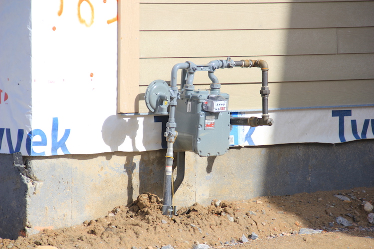


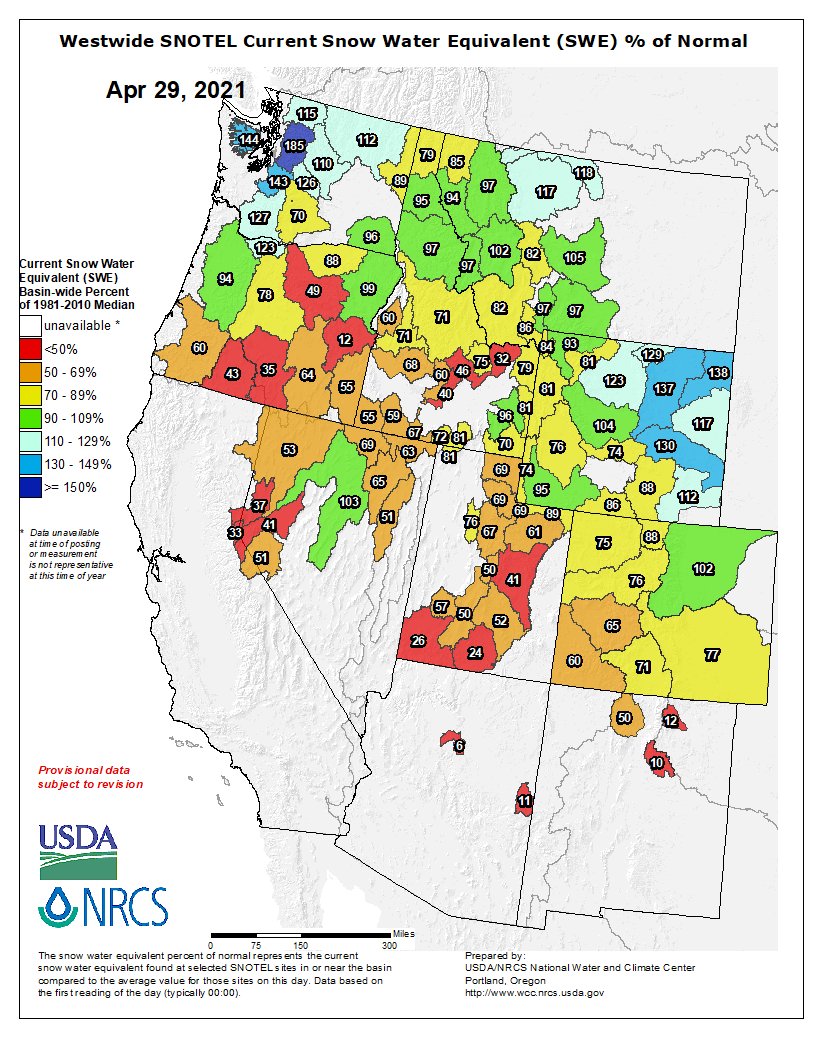

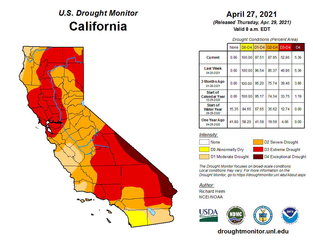


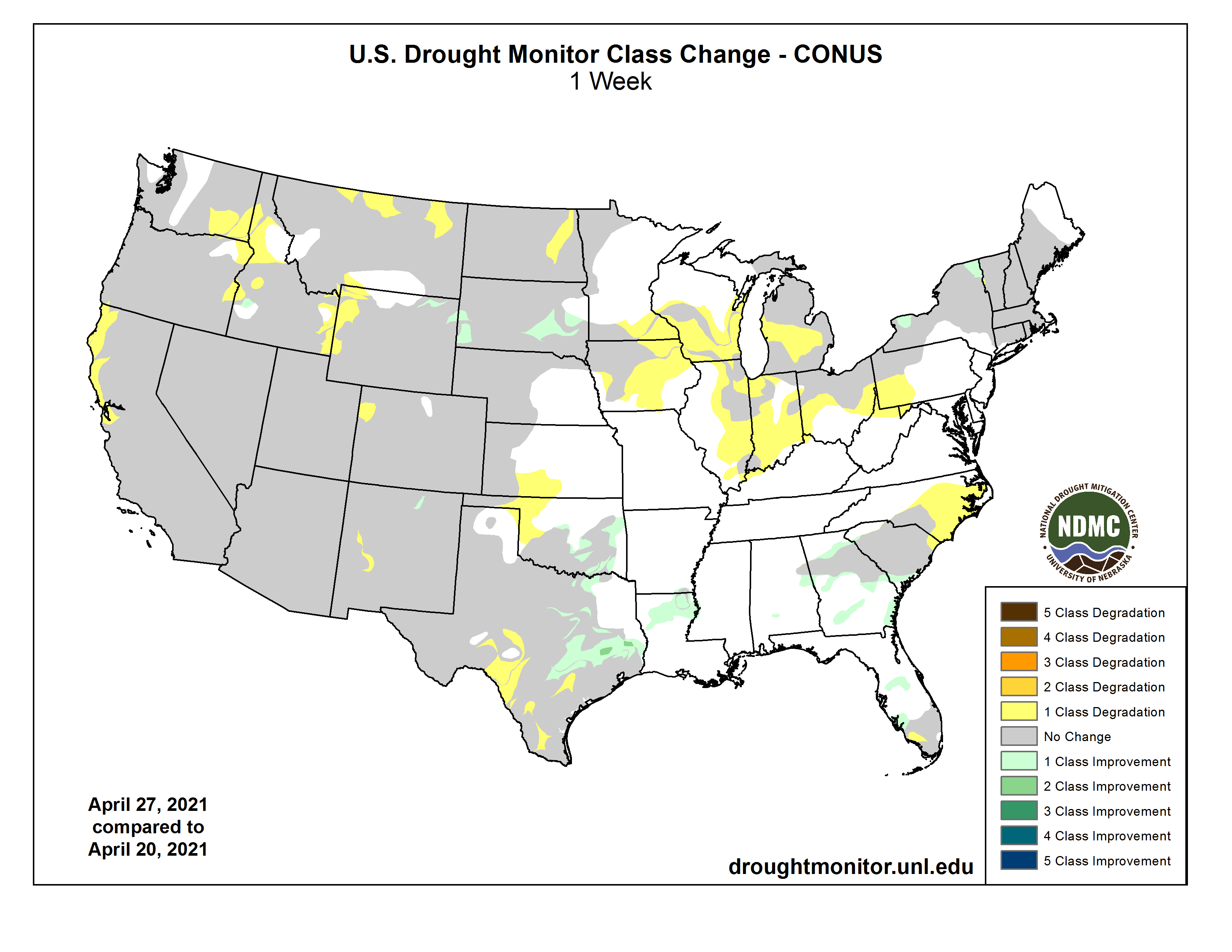
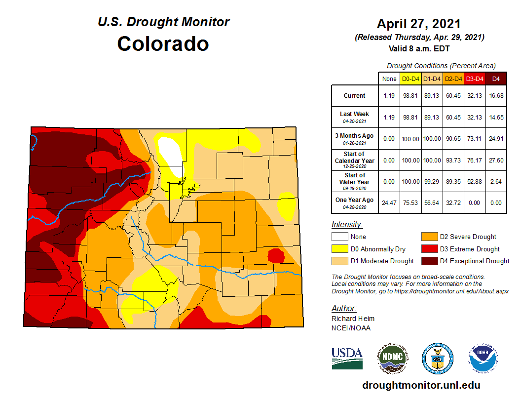

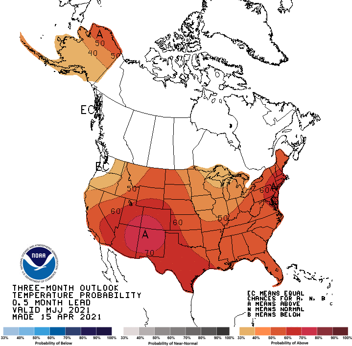
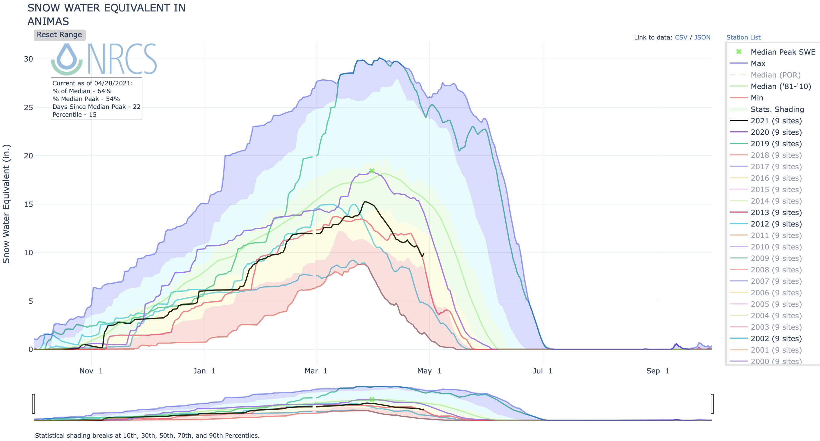
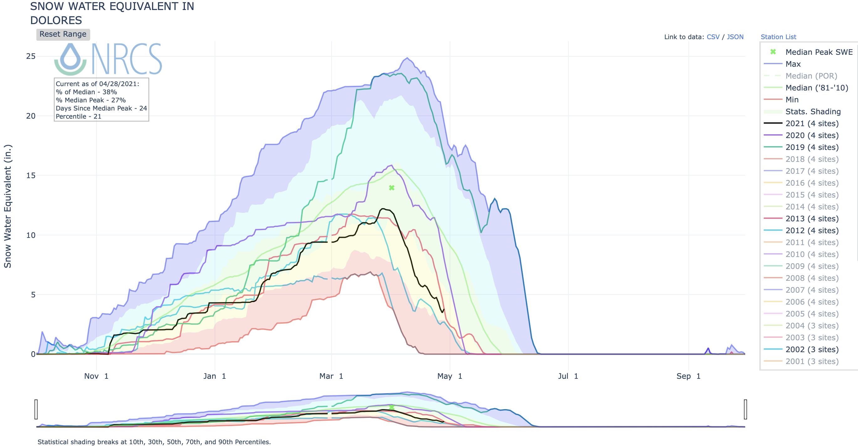
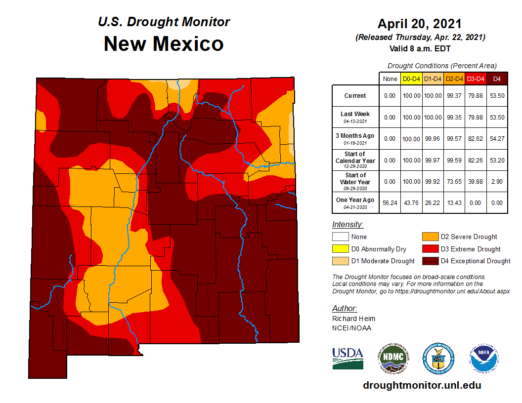

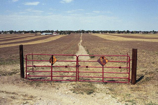

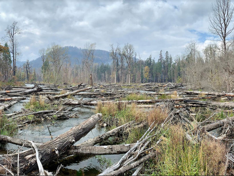

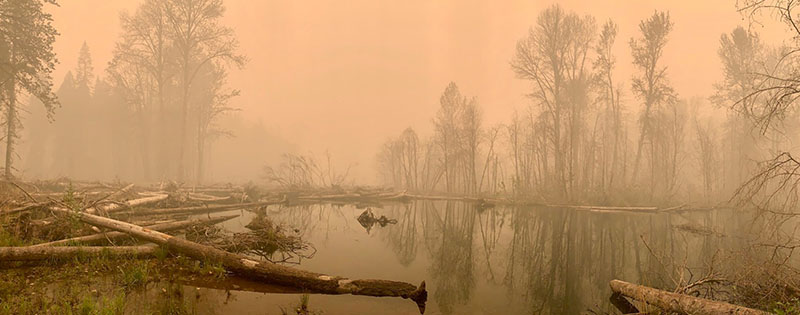
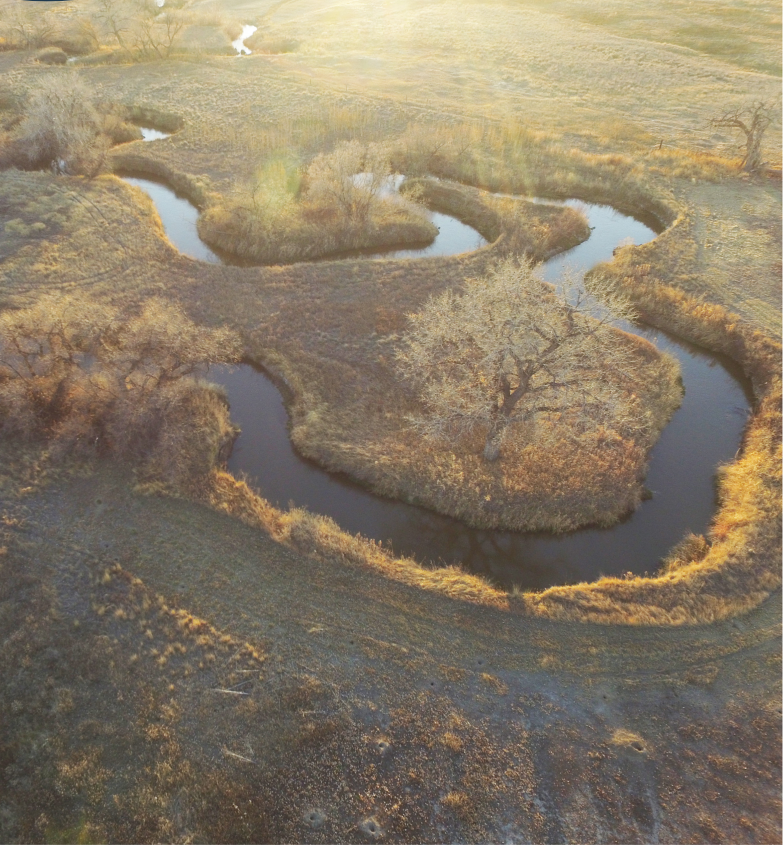
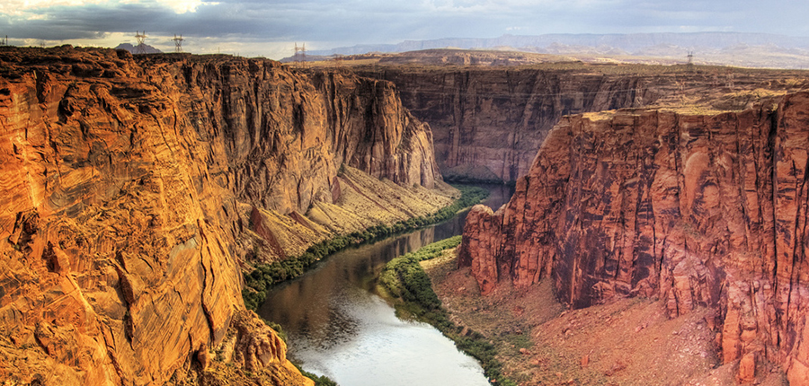

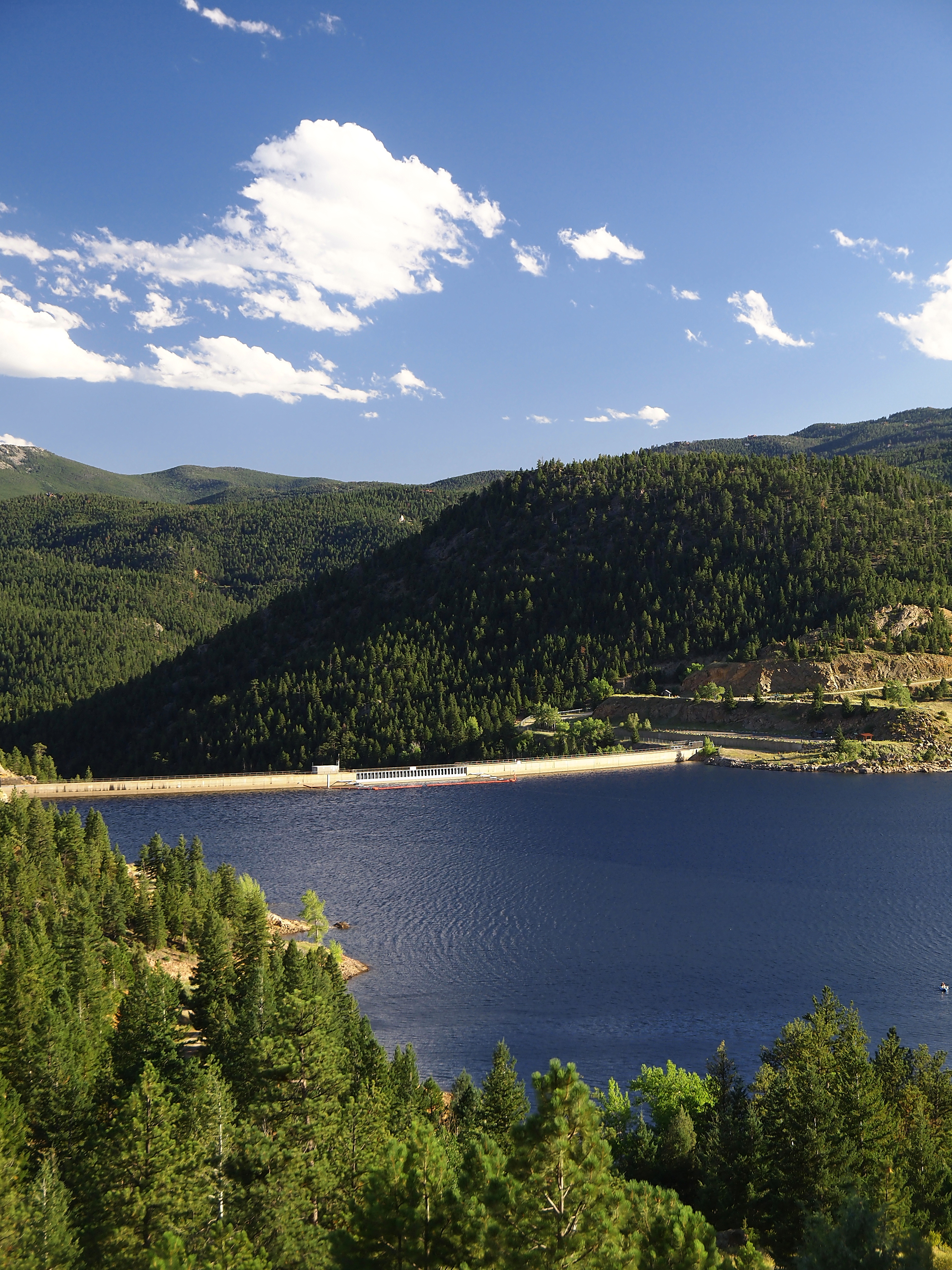


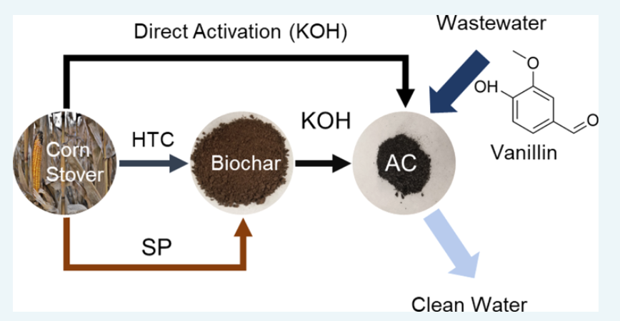


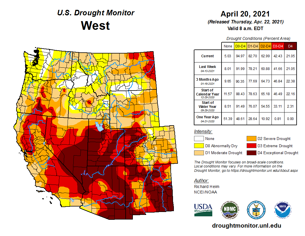
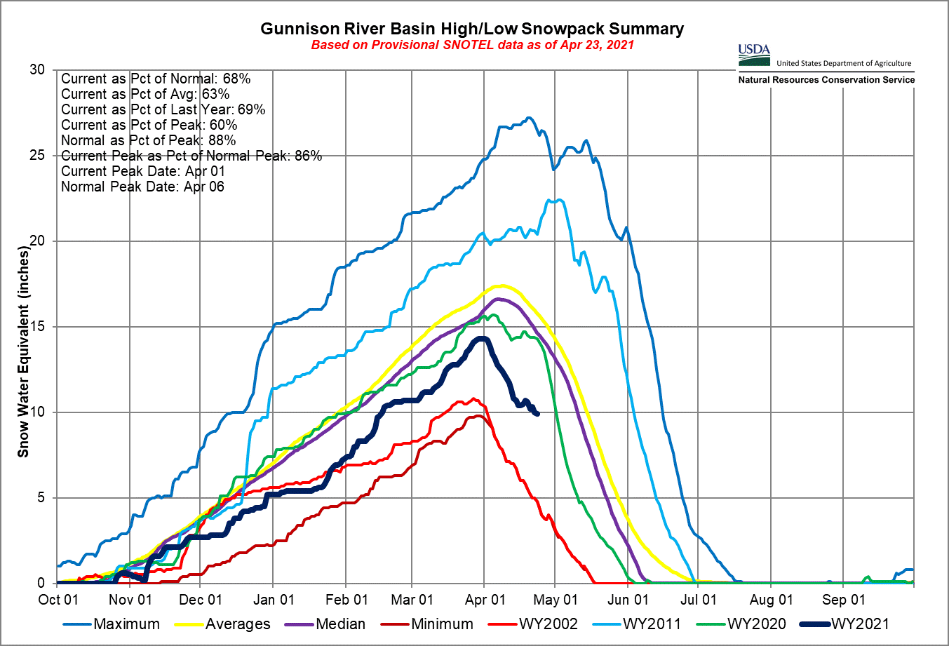
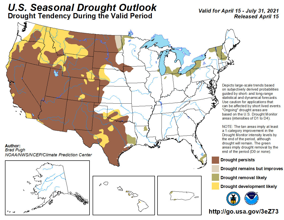


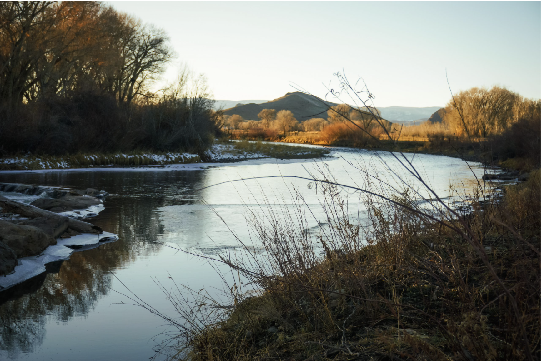


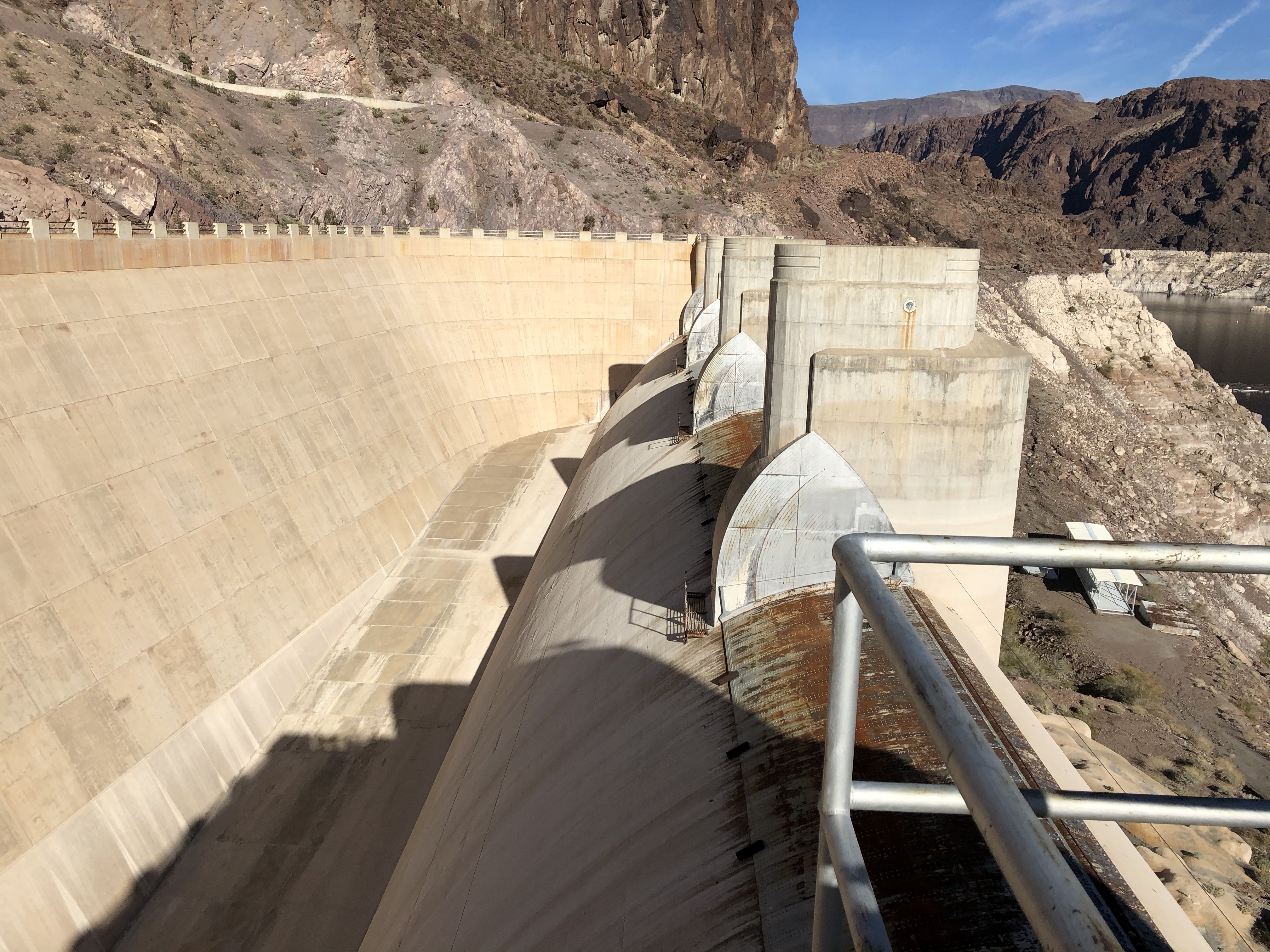
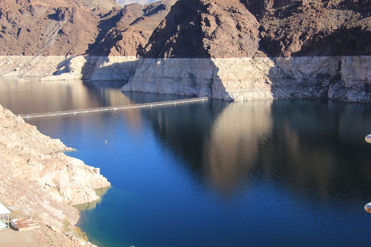


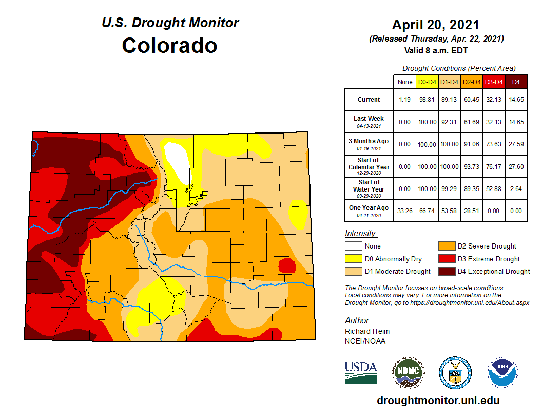
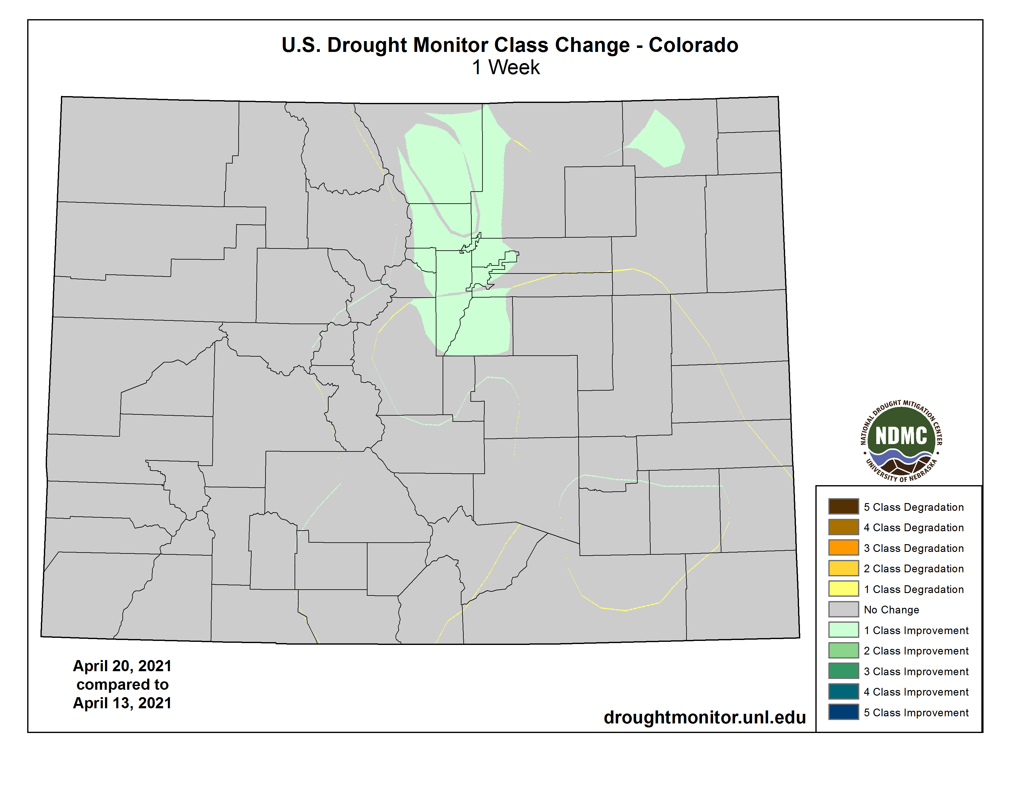

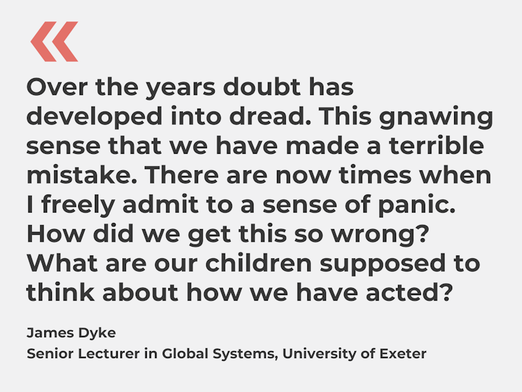
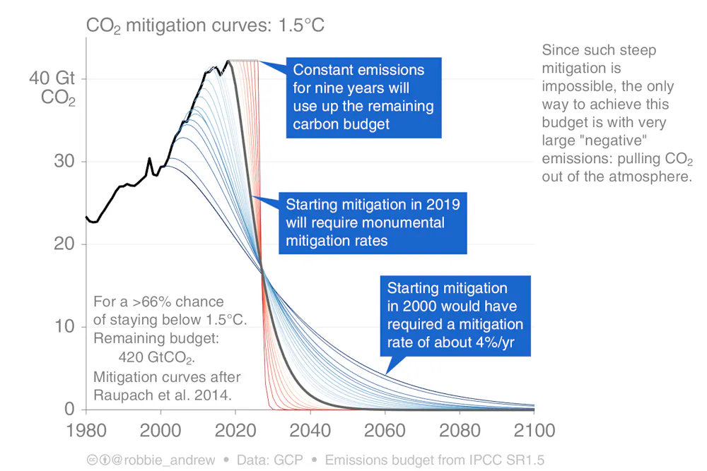

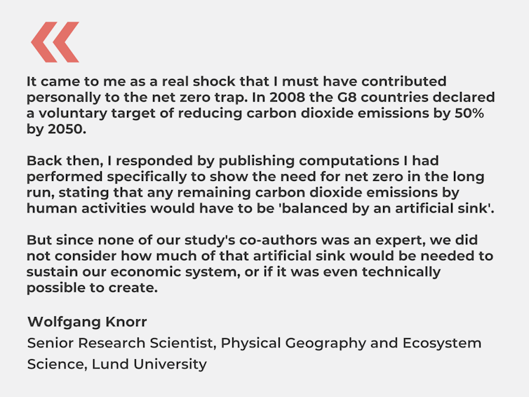


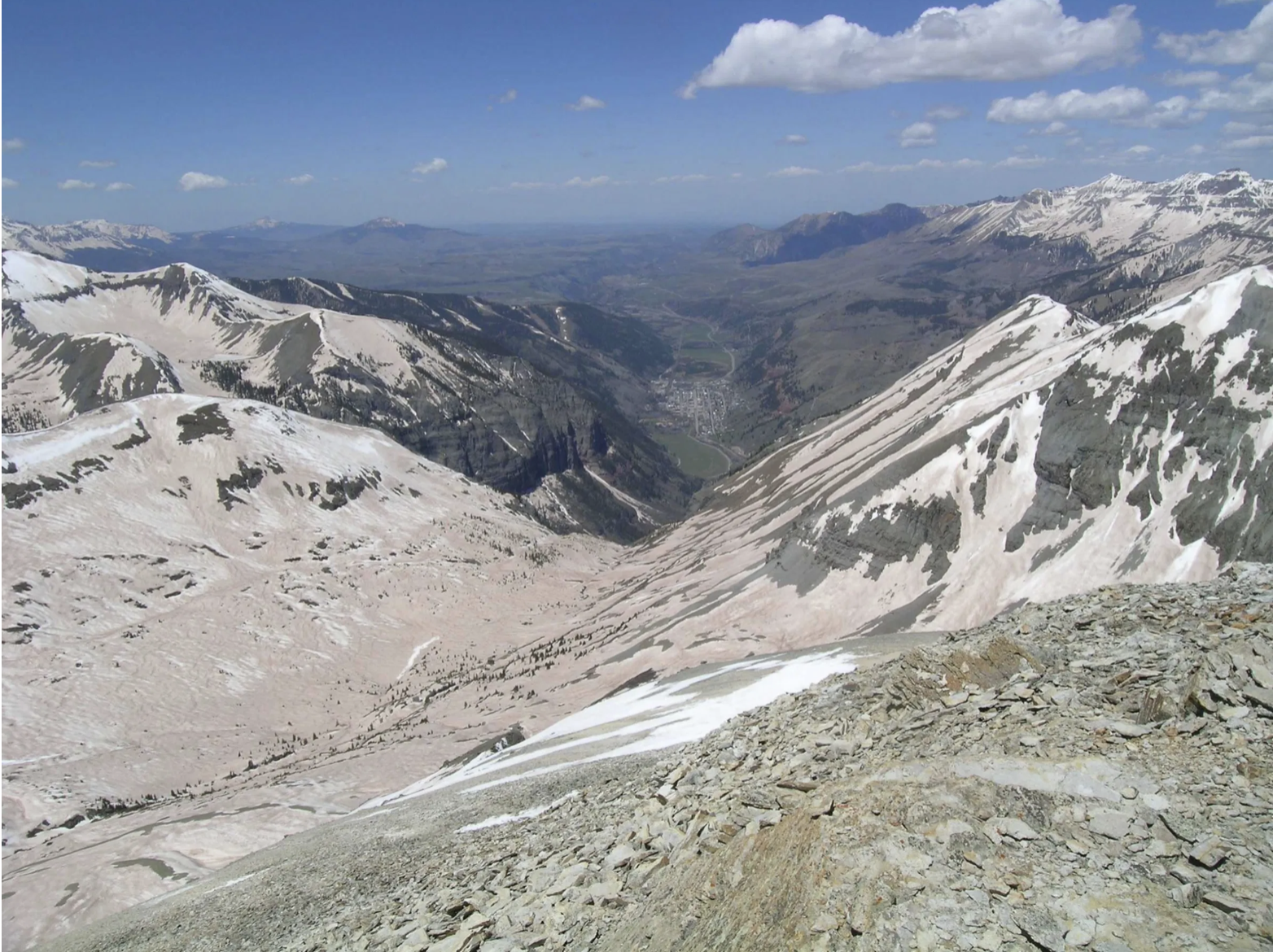


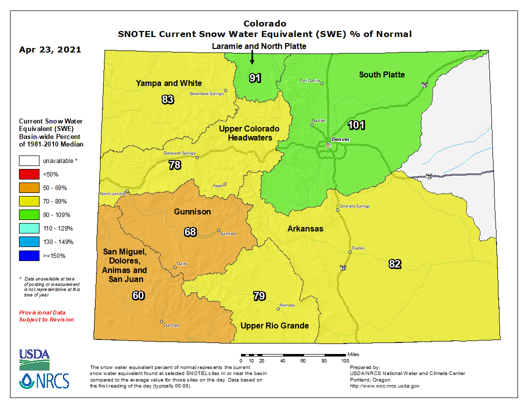

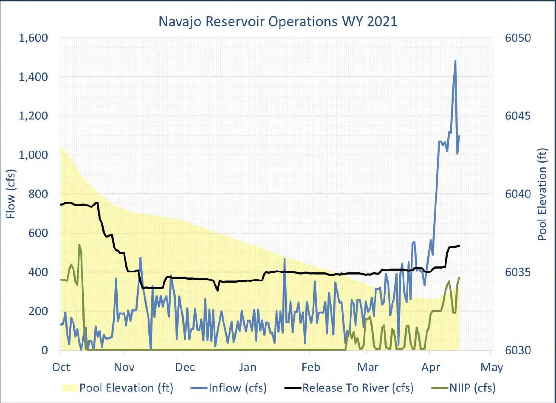

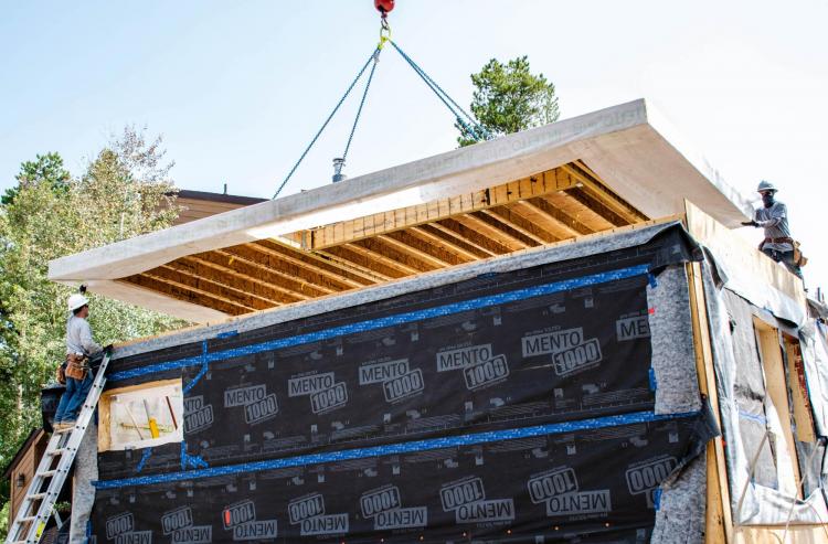


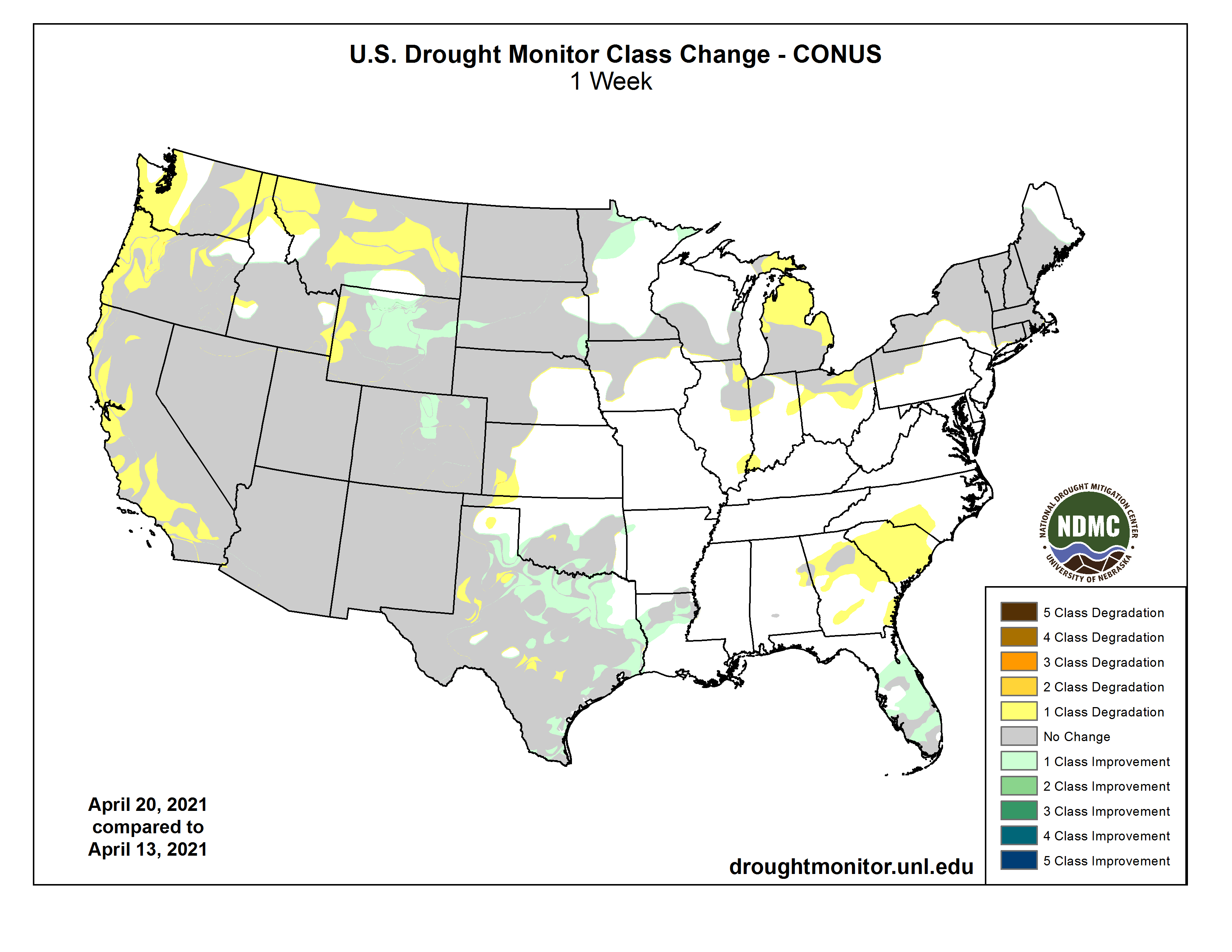

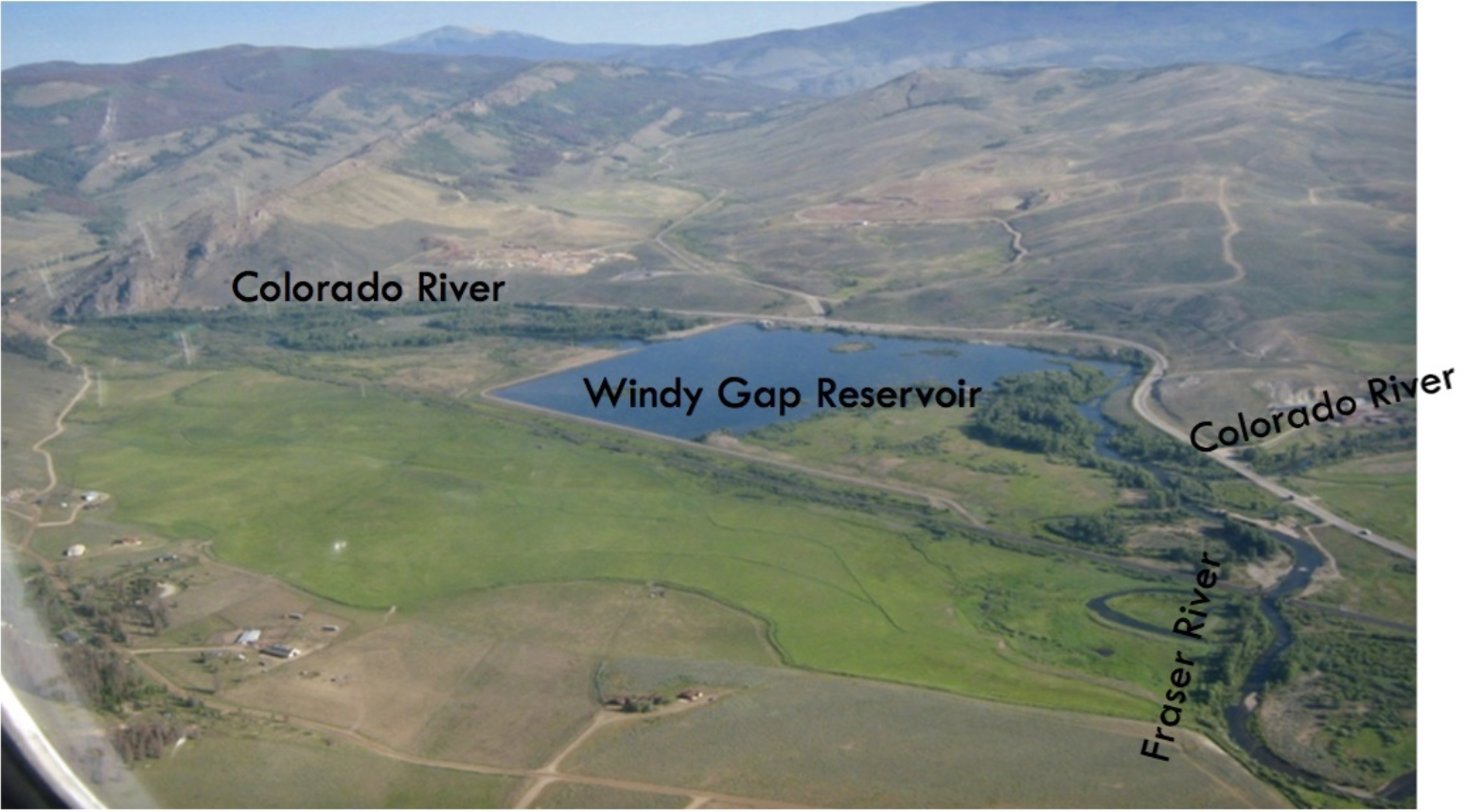
