Navajo Dam operations update (April 21, 2021) #SanJuanRiver #ColoradoRiver #COriver #aridification

The San Juan River, below Navajo Reservoir. Photo: Brent Gardner-Smith/Aspen Journalism

From email from the Bureau of Reclamation (Susan Novak Behery):

In response to decreasing flows in the critical habitat reach, the Bureau of Reclamation has scheduled an increase in the release from Navajo Dam from 500 cubic feet per second (cfs) to 600 cfs on Wednesday, April 21st, starting at 12:00 PM. Releases are made for the authorized purposes of the Navajo Unit, and to attempt to maintain a target base flow through the endangered fish critical habitat reach of the San Juan River (Farmington to Lake Powell).

The San Juan River Basin Recovery Implementation Program recommends a target base flow of between 500 cfs and 1,000 cfs through the critical habitat area. The target base flow is calculated as the weekly average of gaged flows throughout the critical habitat area from Farmington to Lake Powell.

Large Decreases in Upper Colorado River Salinity Since 1929 — @USGS

Here’s the release from the USGS (Heidi Koontz):

Salinity levels in the Upper Colorado River Basin, which covers portions of Wyoming, Colorado, Utah, Arizona and New Mexico, have steadily decreased since 1929, according to a new U.S. Geological Survey study analyzing decades of water-quality measurements.

Photo credit: USGS

Salinity is the concentration of dissolved salt in water. High salinity levels in the Colorado River Basin cause an estimated $300-400 million per year in economic damages across U.S. agricultural, municipal and industrial sectors, as well as negatively impact municipal and agricultural users in Mexico. Reducing high salinity levels can benefit crop production, and decrease water treatment costs and damage to water supply infrastructure.

Findings indicate that large, widespread and sustained downward trends in salinity occurred over the last 50 to 90 years, with salinity levels decreasing by as much as 50% at some locations. The timing and amount of salinity reductions suggest that changes in land cover, land use and climate, in addition to salinity-control measures, substantially affect how dissolved salts find their way into streams that feed the basin.

“Identifying the causes of dropping salinity levels will be important for water managers in the basin so they can anticipate future changes in salinity and optimize salinity-control practices going forward,” said Christine Rumsey, USGS scientist and lead author of the study.

Results show the steepest rates of decline in salinity occurred from 1980 to 2000, coincident with the initiation of salinity-control efforts in the 1980s. However, there has been a consistent slowing of downward trends after 2000 even though salinity-control efforts continued. Significant decreases in salinity occurred as early as the 1940s in some streams, indicating that, in addition to salinity-control projects, other watershed factors are important drivers of salinity change.

“Having access to almost a century’s worth of salinity data provides greater insight to the water-quality changes that occurred prior to the implementation of salinity-control projects,” said Don Barnett, Executive Director of the Colorado River Basin Salinity Control Forum. “These findings are key in helping us understand the processes that cause and reduce salinity and assist us in our goal of protecting water quality in the Colorado River.”

Salinity occurs naturally in water due to weathering and the breaking down of minerals in soils and rock. The same process occurs in areas with irrigated agriculture, when irrigation water flows through soils and dissolves salts which eventually travel into streams. Irrigated areas contribute significantly more to stream salinity compared to areas without irrigated agriculture. Other factors known to affect salinity include geology, land cover, land-use practices, precipitation and climate.

“These findings indicate the issue of salinity in the Colorado River Basin is very complex,” said Rumsey. “Further work is needed to better understand the roles that climate change, land-use, reservoirs, population dynamics and irrigation practices play in salinity issues, which impact the economic well-being of the West and are important to U.S. relations with Mexico.”

Funding for this study was provided by the Colorado River Basin Salinity Control Program, the Bureau of Reclamation and the Bureau of Land Management. In 1974, Congress enacted the Colorado River Basin Salinity Control Act, which directed the Secretary of the Interior to proceed with a program to enhance and protect the quality of water available in the Colorado River for use in the U. S. and Republic of Mexico. The Colorado River Basin Salinity Control Program implements and manages programs to reduce salinity loads, investing millions of dollars per year in irrigation upgrades, canal projects and other mitigation strategies.

The USGS is the primary scientific agency for collecting data on water quality and flow in the nation’s rivers, with more than 13,500 real-time stream, lake and reservoir, precipitation and groundwater data stations across the country. The USGS also conducts analyses of these data to evaluate the status and trends of water-quality conditions.

The new study was published in the journal Water Resources Research.

Landscape view of the San Rafael River in Utah.
Courtesy: Wyatt Brown. Public Domain.
White salts covers the surface of the San Rafael Swell, Utah.
​​​​​​​Credit: USGS. Public domain.

Interstate #water wars are heating up along with the #climate — The Conversation


Aerial view of Lake Powell on the Colorado River along the Arizona-Utah border.
AP Photo/John Antczak

Robert Glennon, University of Arizona

Interstate water disputes are as American as apple pie. States often think a neighboring state is using more than its fair share from a river, lake or aquifer that crosses borders.

Currently the U.S. Supreme Court has on its docket a case between Texas, New Mexico and Colorado and another one between Mississippi and Tennessee. The court has already ruled this term on cases pitting Texas against New Mexico and Florida against Georgia.

Climate stresses are raising the stakes. Rising temperatures require farmers to use more water to grow the same amount of crops. Prolonged and severe droughts decrease available supplies. Wildfires are burning hotter and lasting longer. Fires bake the soil, reducing forests’ ability to hold water, increasing evaporation from barren land and compromising water supplies.

As a longtime observer of interstate water negotiations, I see a basic problem: In some cases, more water rights exist on paper than as wet water – even before factoring in shortages caused by climate change and other stresses. In my view, states should put at least as much effort into reducing water use as they do into litigation, because there are no guaranteed winners in water lawsuits.

Dry times in the West

The situation is most urgent in California and the Southwest, which currently face “extreme or exceptional” drought conditions. California’s reservoirs are half-empty at the end of the rainy season. The Sierra snowpack sits at 60% of normal. In March 2021, federal and state agencies that oversee California’s Central Valley Project and State Water Project – regional water systems that each cover hundreds of miles – issued “remarkably bleak warnings” about cutbacks to farmers’ water allocations.

The Colorado River Basin is mired in a drought that began in 2000. Experts disagree as to how long it could last. What’s certain is that the “Law of the River” – the body of rules, regulations and laws governing the Colorado River – has allocated more water to the states than the river reliably provides.

The 1922 Colorado River Compact allocated 7.5 million acre-feet (one acre-foot is roughly 325,000 gallons) to California, Nevada and Arizona, and another 7.5 million acre-feet to Utah, Wyoming, Colorado and New Mexico. A treaty with Mexico secured that country 1.5 million acre-feet, for a total of 16.5 million acre-feet. However, estimates based on tree ring analysis have determined that the actual yearly flow of the river over the last 1,200 years is roughly 14.6 million acre-feet.

The inevitable train wreck has not yet happened, for two reasons. First, Lakes Mead and Powell – the two largest reservoirs on the Colorado – can hold a combined 56 million acre-feet, roughly four times the river’s annual flow.

But diversions and increased evaporation due to drought are reducing water levels in the reservoirs. As of Dec. 16, 2020, both lakes were less than half full.

Second, the Upper Basin states – Utah, Wyoming, Colorado and New Mexico – have never used their full allotment. Now, however, they want to use more water. Wyoming has several new dams on the drawing board. So does Colorado, which is also planning a new diversion from the headwaters of the Colorado River to Denver and other cities on the Rocky Mountains’ east slope.

Much of the U.S. Southwest and California are in extreme or exceptional drought.
Drought conditions in the continental U.S. on April 13, 2021.
U.S. Drought Monitor, CC BY-ND

Utah stakes a claim

The most controversial proposal comes from one of the nation’s fastest-growing areas: St. George, Utah, home to approximately 90,000 residents and lots of golf courses. St. George has very high water consumption rates and very low water prices. The city is proposing to augment its water supply with a 140-mile pipeline from Lake Powell, which would carry 86,000 acre-feet per year.

Truth be told, that’s not a lot of water, and it would not exceed Utah’s unused allocation from the Colorado River. But the six other Colorado River Basin states have protested as though St. George were asking for their firstborn child.

In a joint letter dated Sept. 8, 2020, the other states implored the Interior Department to refrain from issuing a final environmental review of the pipeline until all seven states could “reach consensus regarding legal and operational concerns.” The letter explicitly threatened a high “probability of multi-year litigation.”

Utah blinked. Having earlier insisted on an expedited pipeline review, the state asked federal officials on Sept. 24, 2020 to delay a decision. But Utah has not given up: In March 2021, Gov. Spencer Cox signed a bill creating a Colorado River Authority of Utah, armed with a US$9 million legal defense fund, to protect Utah’s share of Colorado River water. One observer predicted “huge, huge litigation.”

How huge could it be? In 1930, Arizona sued California in an epic battle that did not end until 2006. Arizona prevailed by finally securing a fixed allocation from the water apportioned to California, Nevada and Arizona.

Southwest Utah’s claim to Colorado River water is sparking conflict with other western states.

Litigation or conservation

Before Utah takes the precipitous step of appealing to the Supreme Court under the court’s original jurisdiction over disputes between states, it might explore other solutions. Water conservation and reuse make obvious sense in St. George, where per-person water consumption is among the nation’s highest.

St. George could emulate its neighbor, Las Vegas, which has paid residents up to $3 per square foot to rip out lawns and replace them with native desert landscaping. In April 2021 Las Vegas went further, asking the Nevada Legislature to outlaw ornamental grass.

The Southern Nevada Water Authority estimates that the Las Vegas metropolitan area has eight square miles of “nonfunctional turf” – grass that no one ever walks on except the person who cuts it. Removing it would reduce the region’s water consumption by 15%.

Water rights litigation is fraught with uncertainty. Just ask Florida, which thought it had a strong case that Georgia’s water diversions from the Apalachicola-Chattahoochee-Flint River Basin were harming its oyster fishery downstream.

That case extended over 20 years before the U.S. Supreme Court ended the final chapter in April 2021. The court used a procedural rule that places the burden on plaintiffs to provide “clear and convincing evidence.” Florida failed to convince the court, and walked away with nothing.The Conversation

Robert Glennon, Regents Professor and Morris K. Udall Professor of Law & Public Policy, University of Arizona

This article is republished from The Conversation under a Creative Commons license. Read the original article.

#Snowpack news (April 20, 2021): Early peaks are the norm

Click on a thumbnail graphic to view a gallery of snowpack data from the NRCS.

Here’s the Westwide SNOTEL basin-filled map.

Westwide SNOTEL basin-filled map April 20, 2021 via the NRCS.

Dear 2021 #Monsoon: Don’t be lame again this year #cwcbwatf

This pretty much sums up the mood at today’s DNR Water Availability Task Force Meeting.

Saving the #ColoradoRiver — James Eklund #COriver #aridification #DemandManagement

From James Eklund (click through for the citations):

How demand management can save the Colorado River

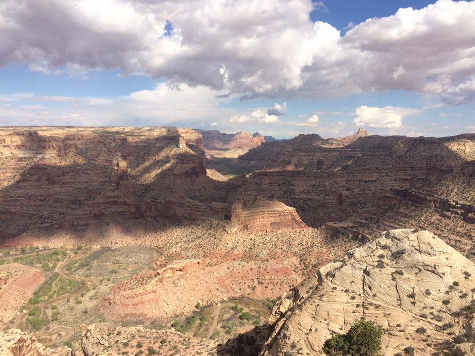
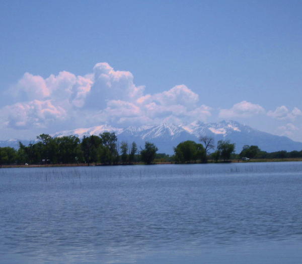
In 1887, after a week at sea, my great-great grandmother Mary Gunderson led her blind husband, Ole, down the gangplank into New York City. Ole was the victim of a mining accident only days before their scheduled departure for America. The economy in Norway had collapsed and the couple sought a brighter future for their two young sons. The family made its way to the new (then twelve-years-old) state of Colorado to homestead on a tributary to the Grand River. The federal government had recently removed the indigenous Ute peoples from the land and opened it to homesteading. The river that dominated this landscape has carried many names, among them Rio del Tizon, the Grand River, and the Colorado River. For eleven years, 1873-1883, the river’s performance was below what once was considered average (i.e. the average flow of the river 1906-1995). (Woodhouse, 2006). When the Gundersons arrived, the flows had returned to average and were about to enter a wet period that would form the backdrop for the consequential first round of modern management negotiations. (Woodhouse, 2006).

The river that carved the Grand Canyon now shaped new economies — economies that quickly grew too big to fail. Westerners sought ways to control and harness the river while confronting legal and hydrologic uncertainty. In 1922, the seven sovereign Basin States achieved a form of legal certainty through an interstate compact expressly consented to by Congress. The Colorado River Compact (Compact) was the first interstate compact apportioning water use in the nation’s history. The Compact divided the river basin in two, apportioning Colorado River system water use between the Upper Basin and the Lower Basin. (The Upper Basin includes: Colorado, New Mexico, Utah and Wyoming; while the Lower Basin includes: Arizona, California and Nevada) The basin states and the federal government adopted agreements, laws, policies, and practices based on their understanding of the river’s historic performance. Taken together, these instruments constitute what is now known as the “Law of the River.” In 1935, a measure of hydrologic certainty was achieved, for the Lower Basin, with the filling of Lake Mead behind Hoover Dam. If the compact negotiators had been correct in their assumption that Colorado River flows would remain stationary, this article would end here. You, dear reader, are not so fortunate.

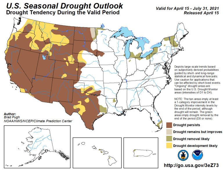
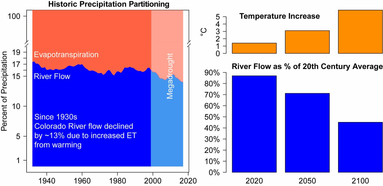
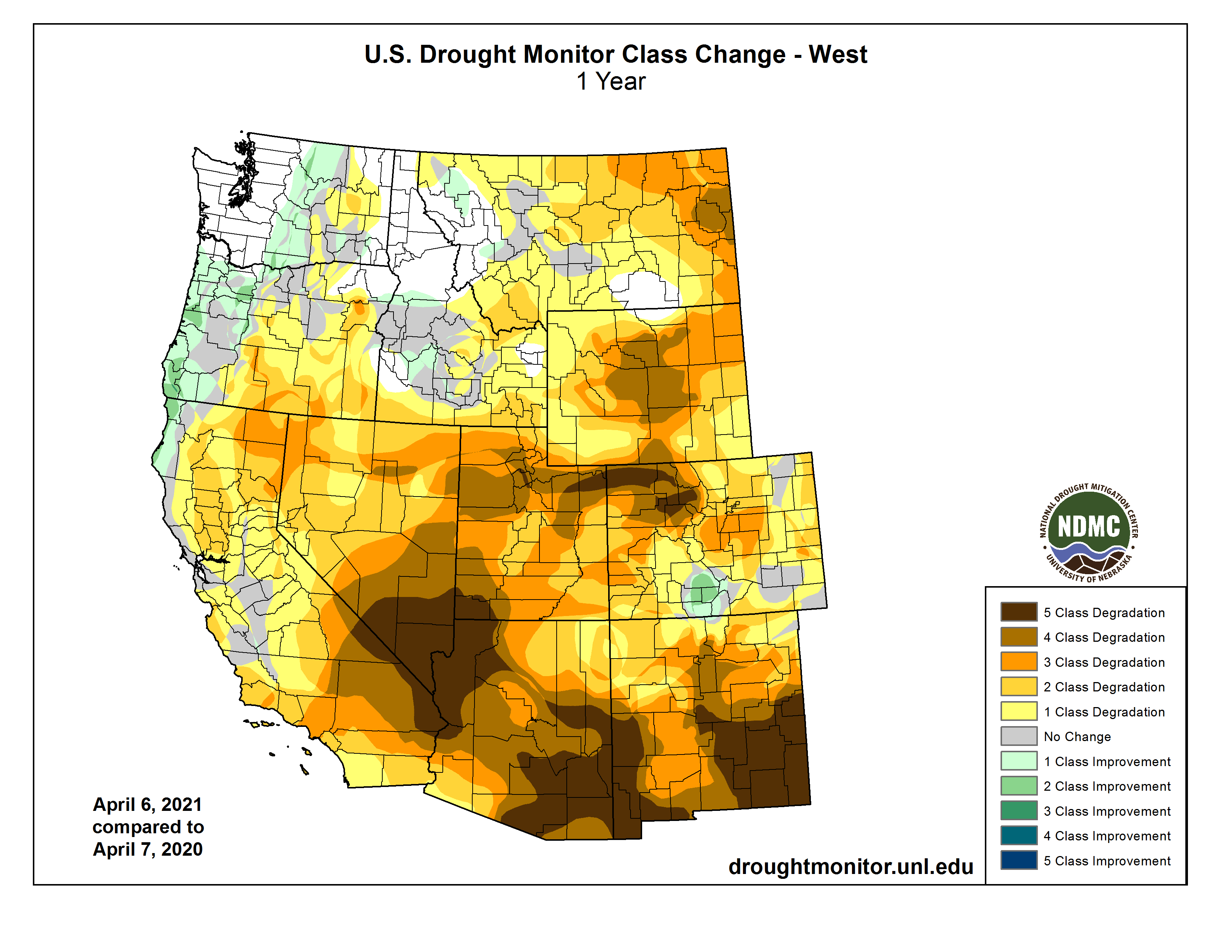
Anthropomorphic climate change has fundamentally shifted Colorado River hydrology and the foundation upon which the Law of the River was built. The once average annual river inflows of 18 million acre-feet were experienced and assumed by interstate negotiators — while we now only see 12.5 million acre-feet. In addition, more carbon in our atmosphere is producing warmer temperatures. Consequently, not only are we receiving less precipitation, but more of what we do receive falls in the form of rain instead of snow.

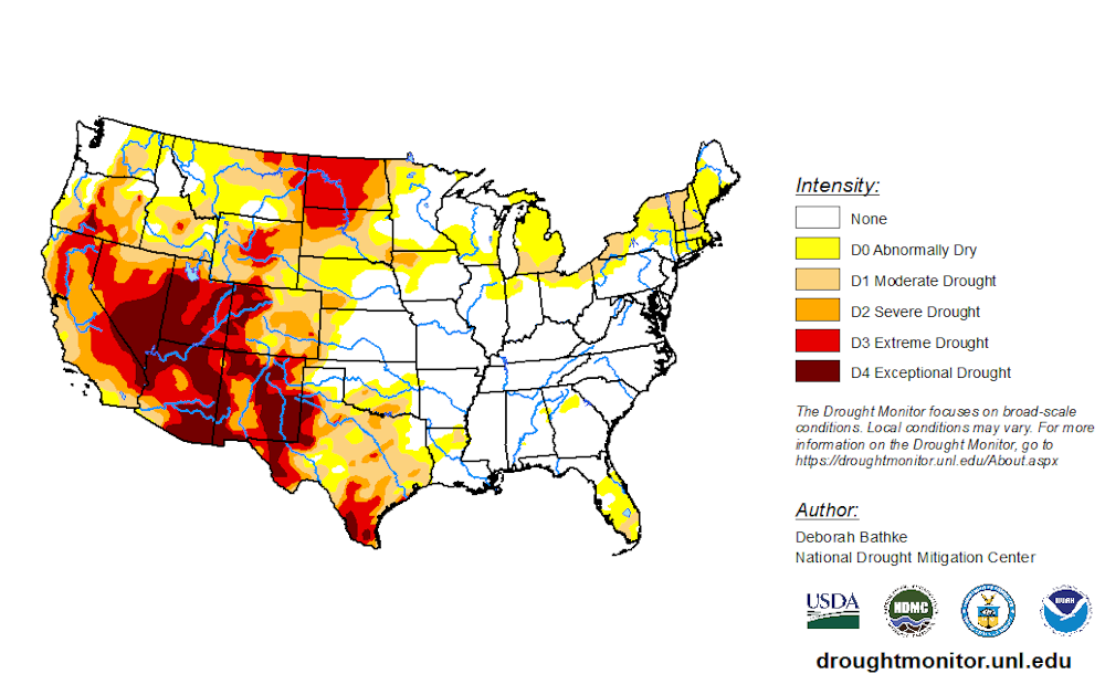
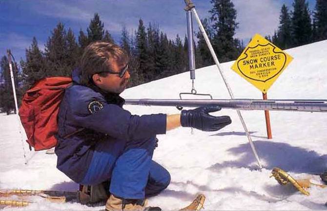
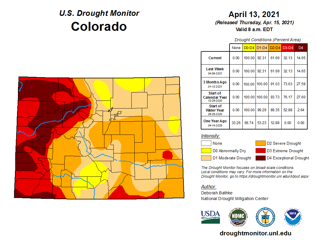
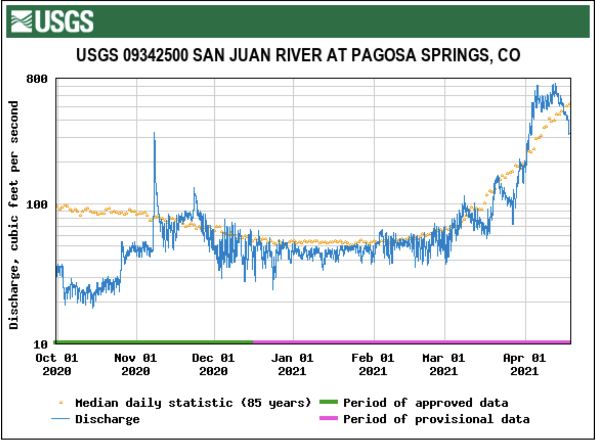
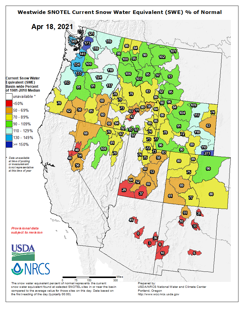
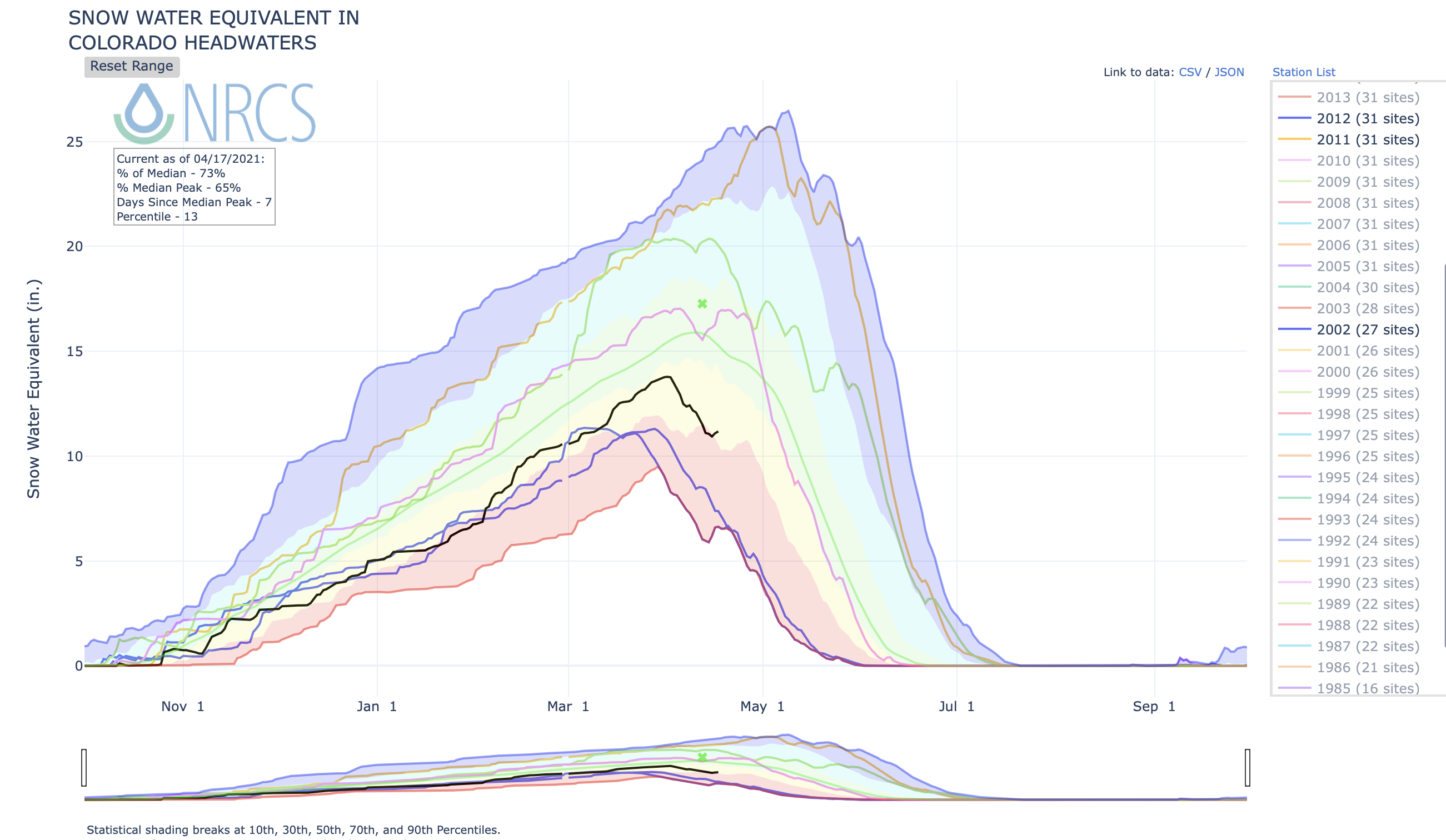
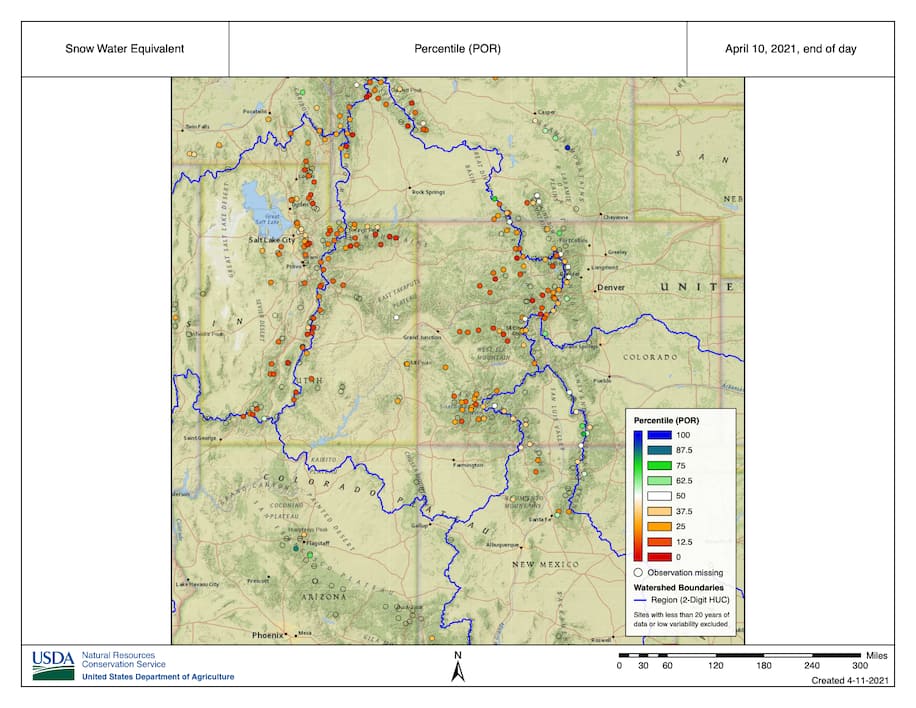
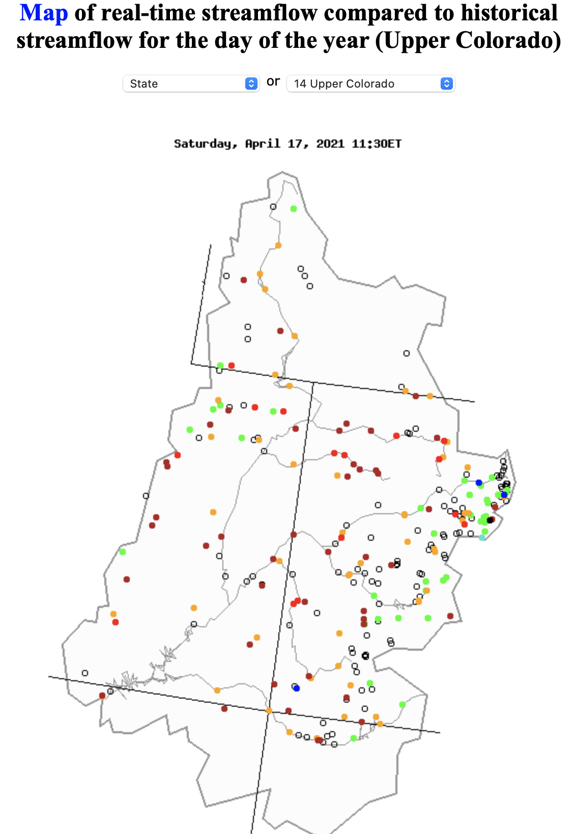
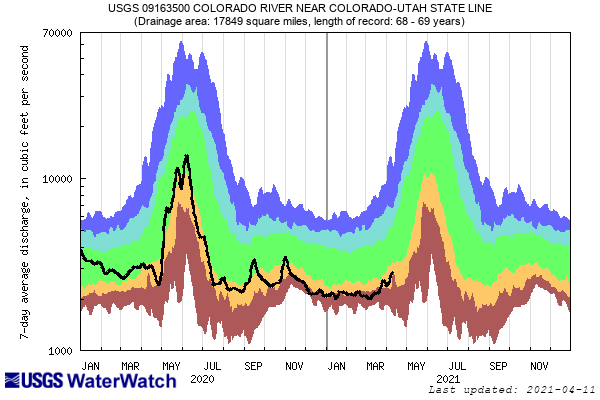
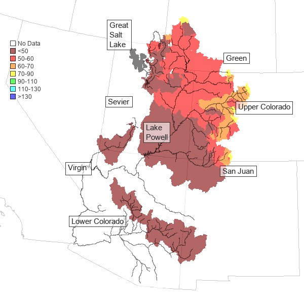
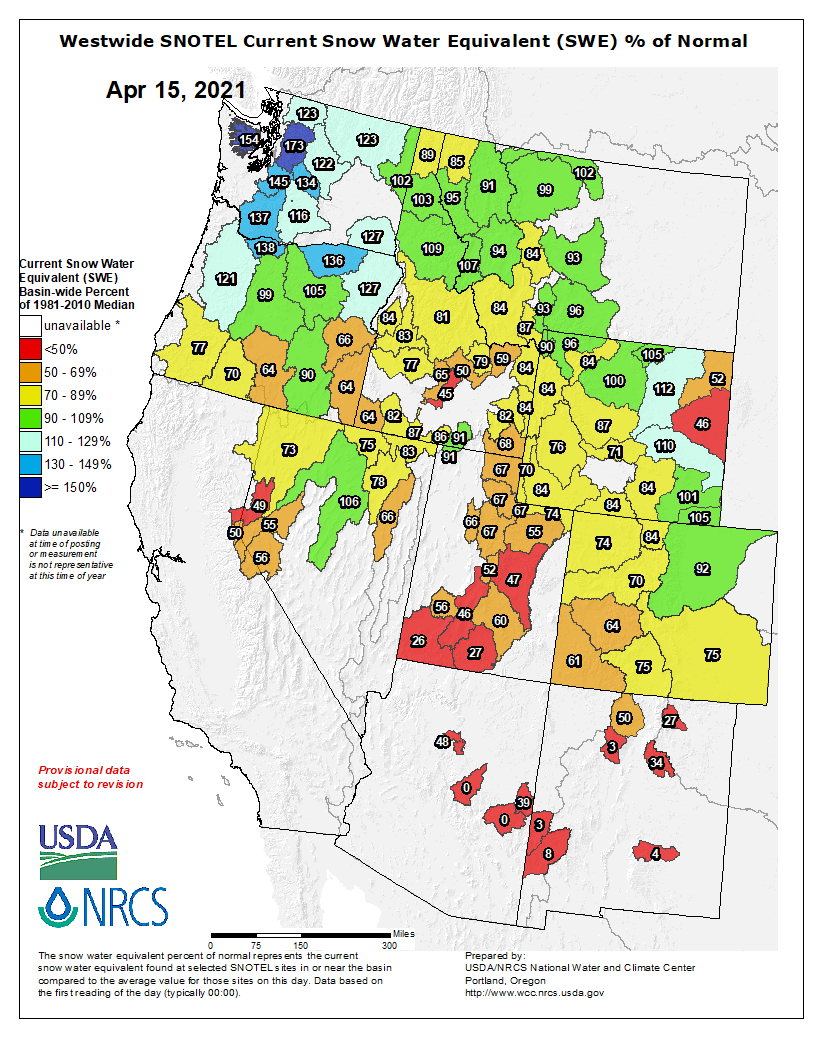
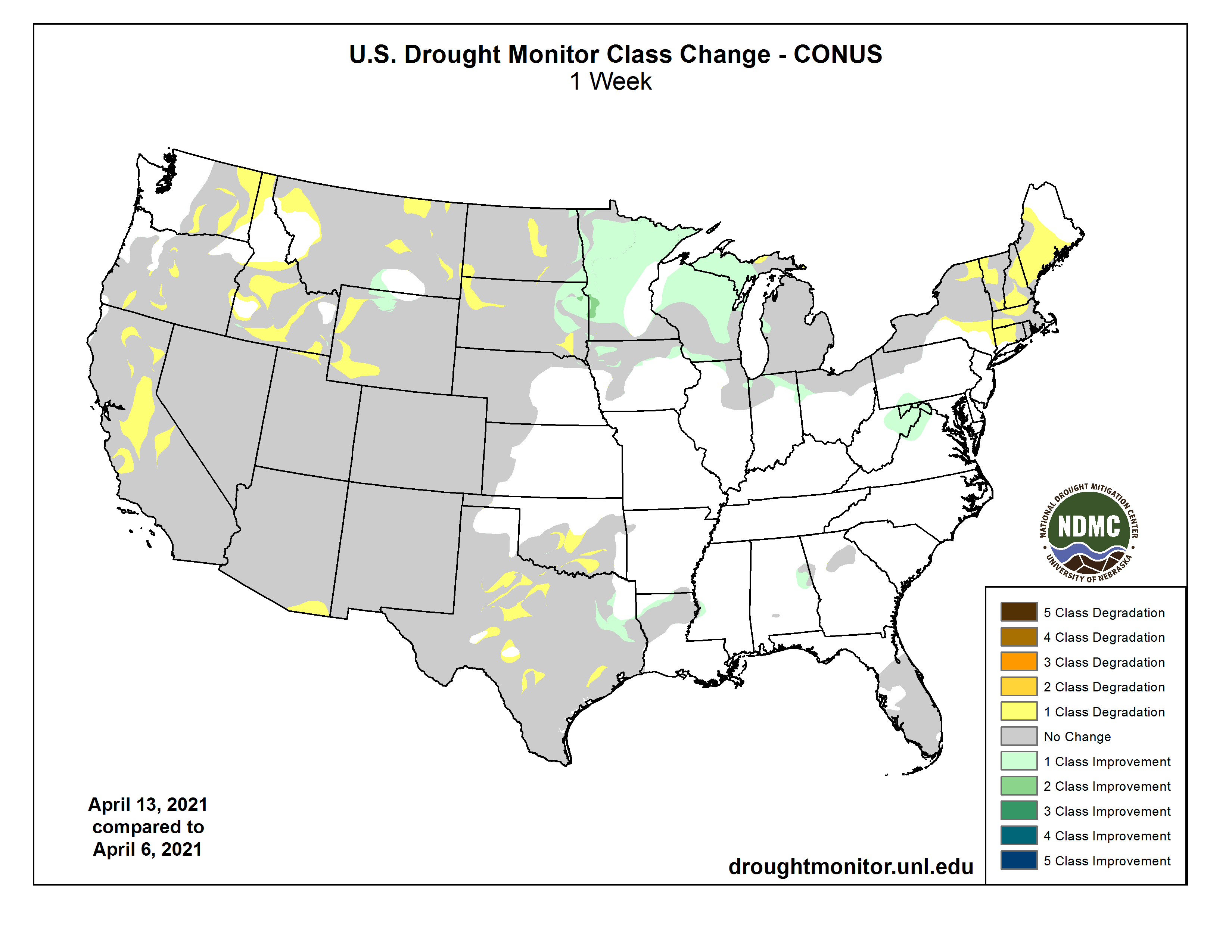
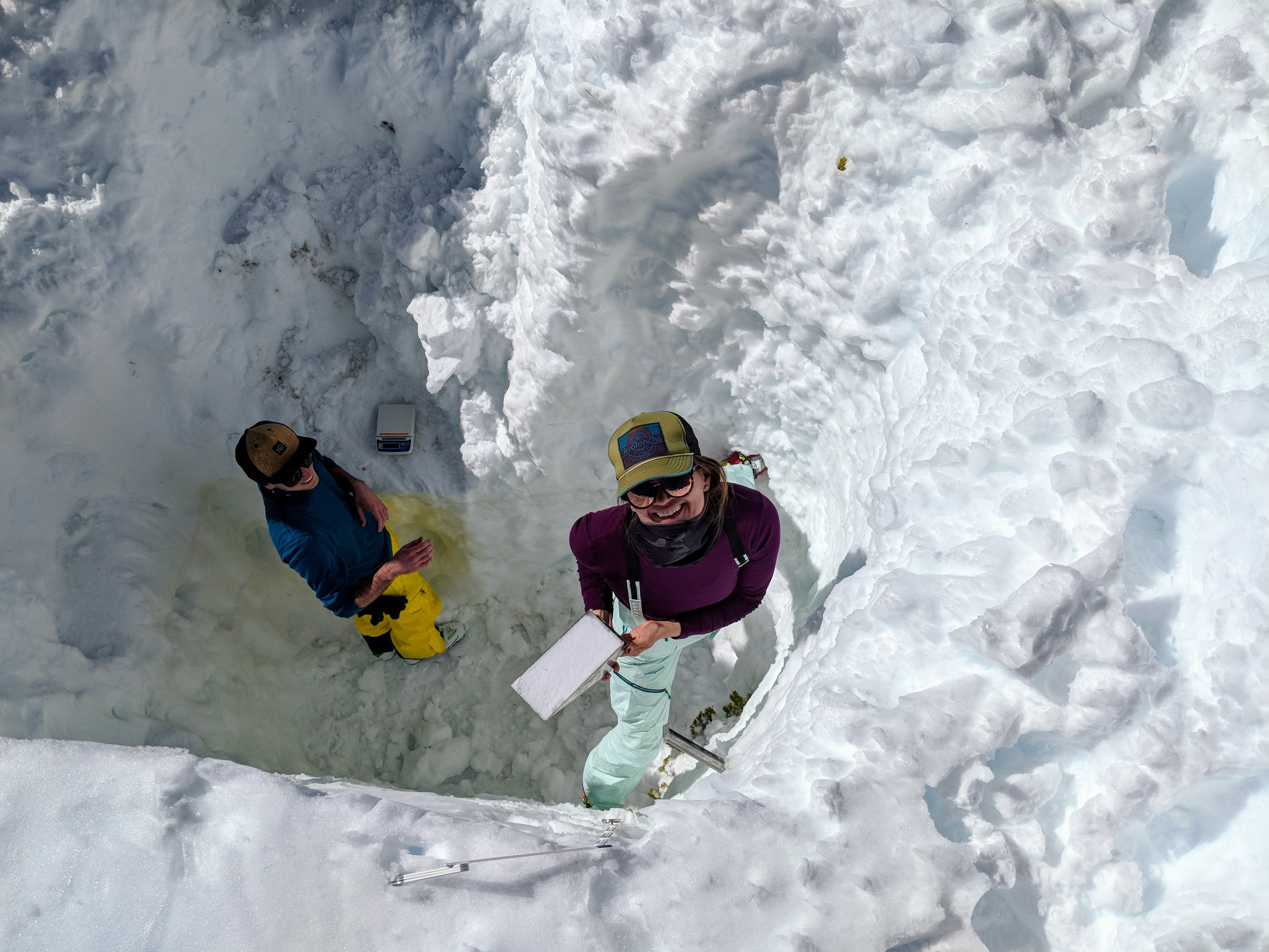
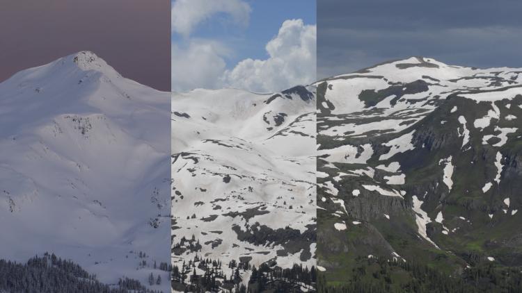
Moreover, snowpack behavior, once considered somewhat predictable and reliable, is now dramatically underperforming. In the 2020 water year, the Upper Basin saw above average snowpack (114%) misbehave to such an extent that it produced a mere 55% of average runoff. (Milly, 2020). These trends can be expected to continue. (Plucinski, 2019). Reasons for this are, firstly, the “aridification” of the Colorado River Basin, where temperature has risen and is rising such that sublimation occurs at higher rates and liquid water fails to occur. The second reason is the “spongeification” of the Colorado River Plateau whereby dry soils and depleted groundwater aquifers soak up the runoff that does materialize.

Nevertheless, the demands placed and the economies reliant on the Colorado River are still too big to fail. Our challenge, therefore, is to shift the Law of the River to accommodate the change in hydrology and encourage practices that can help save the river. Too small a shift risks failing to adequately address the challenge. A larger — perhaps necessary — response may upset the carefully crafted agreements that sovereigns and stakeholders throughout the basin have labored to reach. Unfortunately, the latest data and analysis shows we must prepare for river flows reduced by climate change.

Readying the Colorado River system and the 40 million people reliant on the river in seven states, two countries, and numerous American Indian Tribes requires a rethinking of the fundamental terms of the Law of the River. The picture can seem bleak and depressing — but take heart! These challenges also represent excellent opportunities to develop more reliable and sustainable Colorado River management. We can manage our way out of this problem while addressing climate change, thus saving the Colorado River for future generations. Demand management is a necessary management tool that we should be wielding with greater urgency.

The Effects of Climate Change on the Colorado River

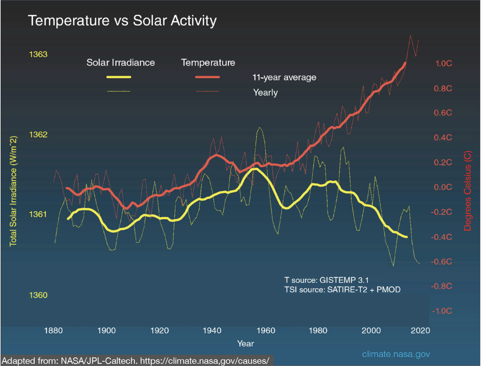
Anthropomorphic climate change is consequential for Colorado River management and presents an existential threat to communities, economies, and environments in the basin. More carbon in our atmosphere produces warmer temperatures. (NASA, 2011). Since the Gundersons homesteaded, average global temperatures have risen 1.4 degrees Fahrenheit. (NASA, 2011).

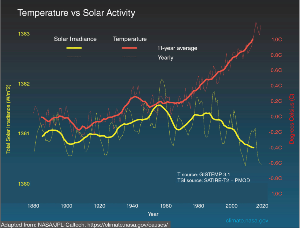
The above graph compares global surface temperature changes (red line) and the Sun’s energy that Earth receives (yellow line) in watts per square meter since 1880. The amount of solar energy that Earth receives has followed the Sun’s natural 11-year cycle of small ups and downs with no net increase since the 1950s. Over the same period, global temperature has risen markedly.

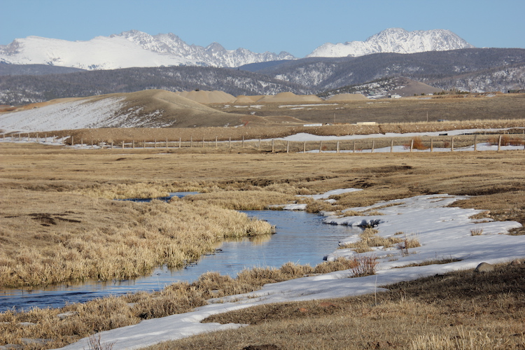
Not only are we receiving less precipitation, but more of what we do receive falls in the form of rain instead of snow.

In our integrated environmental systems, the problem is self-perpetuating:

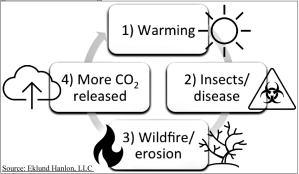
1) WARMING: more carbon dioxide in our atmosphere
traps solar radiation and results in warmer
temperatures

2) INSECTS/DISEASE: warmer temperatures provide a more favorable climate for forest insects and diseases 3) FOREST LOSS: the loss of entire forests in the Rocky Mountains to insects or disease contributes to increasingly destructive wildfire, desertification, and erosion of soils

4) CO2 RELEASE: wildfire and soil erosion and degradation causes the release of carbon that was once sequestered into the atmosphere

5) DOWNWARD SPIRAL: the cycle continues and conditions worsen.

The most current scientific analysis and review of Colorado River data supports this unfortunate dynamic: “Our results underscore that greenhouse gas emissions reduction and moderating or decreasing atmospheric greenhouse gas concentrations may be critical to maintaining sufficient streamflow volumes to satisfy current and future water use while also complying with interstate and international water allocation agreements.” (Wheeler, 2021; Miller, 2021).

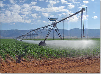
Agriculture in the Colorado River Basin

Agriculture in the Western US has declined and so have our soils. Just as soil degradation has contributed to our condition, so too can soil regeneration be our salvation. The latest Agriculture Census, released in 2019, shows the amount of US agricultural land continued to decline as did the overall number of farming and ranching operations. The 2.04 million farms and ranches marked a three percent decline from 2012. Simply put, land use practices and climate change are resulting in erosion of our soils. (Borrelli, 2020).

Another principal threat to irrigated agriculture in the Western US is the practice of permanently transferring water from irrigated land (aka “buy-and-dry”). (Colorado’s Water Plan, 2015). “Buy-and- dry” is generally disfavored under state water policy due to its potential to negatively impact agricultural communities and economies. (Id.). Colorado’s Water Plan calls for measurable shifts from buy-and-dry to alternative transfer methods such as lease-fallowing arrangements.

If necessity is the mother of invention, some good news in all the dismaying water data may be that less water becomes the crucible in which new practices and collaborations take shape to: regenerate soils; increase sustainable food production; sequester carbon; and conserve water. Regenerative cropping and grazing management practices can increase water percolation and retention in soils. (Elevitch, 2018; Teague, 2018). A Demand Management program could encourage wider adoption of these practices while freeing up irrigation water that could help with water levels at Lake Powell. The science seems clear that even more strategic farming and ranching practices will be necessary to grow more with less water in a Colorado River Basin impacted by climate change while avoiding buy-and-dry. (Wheeler, 2021; Miller, 2021). A Demand Management program appears critical to provide agricultural producers with additional options moving forward.

The Law of the River

The agreements, laws, policies, and practices that govern the use of Colorado River water constitute the “Law of the River.” Complete and thorough descriptions of this canon exist elsewhere. For our purposes, it is sufficient to note the foundation of the Law of the River: i.e., the Colorado River Compact of 1922. The Compact divided the river basin at Lee Ferry, Arizona, and apportioned 7.5 million acre- feet of consumptive use to the Upper Basin and 7.5 million acre-feet to the Lower Basin. Importantly, the Compact also prohibited the Upper Basin States from “caus[ing] the flow of the river at Lee Ferry to be depleted below an aggregate of 75,000,000 acre-feet for any period of 10 consecutive years…” (Compact, 1922). The intent of this provision was to guard against the Upper Basin exceeding its apportionment from a river that experienced annual flows of 18 million acre-feet on average. When, however, climate change has reduced average flows to 12.5 million acre-feet, the non-depletion provision effectively places the entire burden of climate change on the Upper Basin. The negotiators and signatories to the Compact did not anticipate climate change and, therefore, did not intend one basin to bear the brunt of reduced river flows. For this reason, the non-depletion provision has become the chief obstacle to the equitable apportionment it was originally crafted to enforce.

This fact also suggests that minor surgery on the Law of the River provides too little medicine, too late. A recent study of reservoir elevations and inflows warns, “…the current management approach that allows only incremental changes to the Law of the River may be insufficient to adapt to the future conditions of the basin.” (Wheeler, 2021). Instead, the perfect storm of climate change, aridification, and a structural deficit calls for major, evasive (and probably invasive) action.

Demand Management: Friend or Foe?

For nearly two years, the Upper Basin has engaged in lively debate about Colorado River Demand Management. Unfortunately, the hydrology has not slowed its descent to accommodate these discussions. The positive view of Demand Management holds that a program paying users to temporarily and voluntarily leave water in the river is a key tool to address a falling system in a manner that recognizes the American West’s system of purchasable and transferable water rights. The negative position fears such a program would accelerate the decline of irrigated agriculture or the environment in the Upper Basin. Ironically, in a desperate attempt to cling to water that is no longer available, this position would limit agricultural water users’ access to the very capital that could keep them in production. Importantly, the negative view offers no alternative solution to address a climate-change-impacted river system. Far from being a foe, read on to learn why Demand Management should be embraced like an old friend.

Pre-Continency Plan Disincentive
re: Lake Powell & Lake Mead

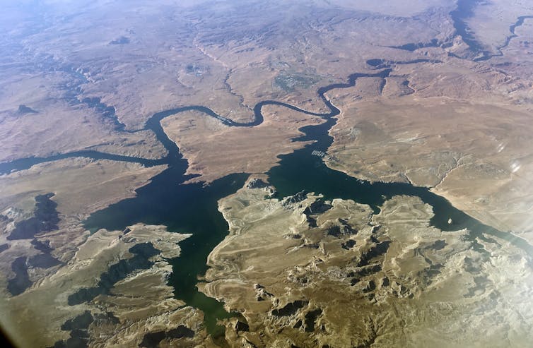
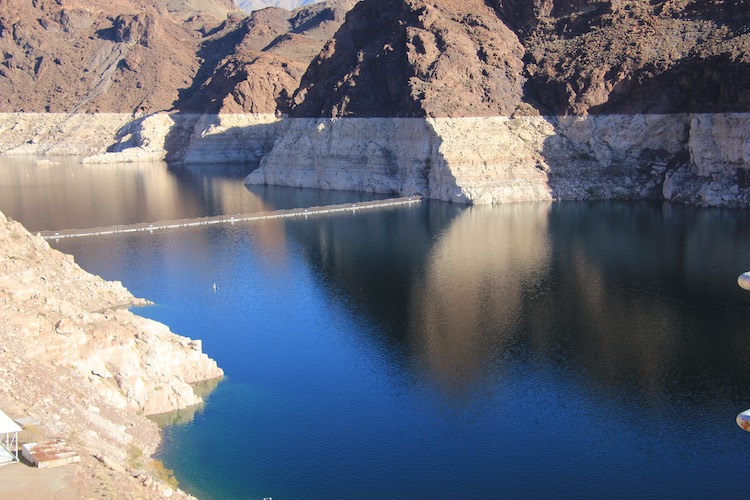
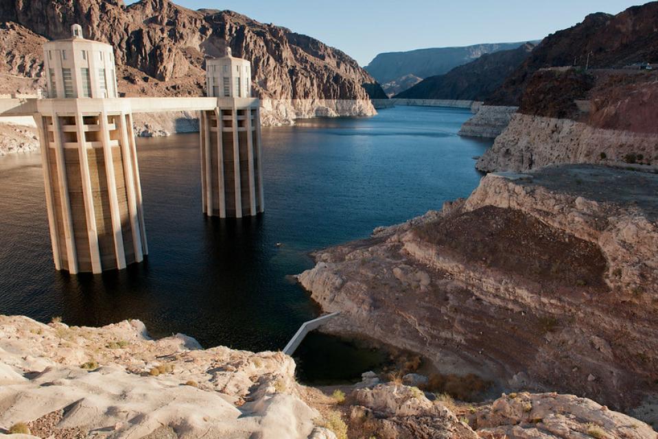
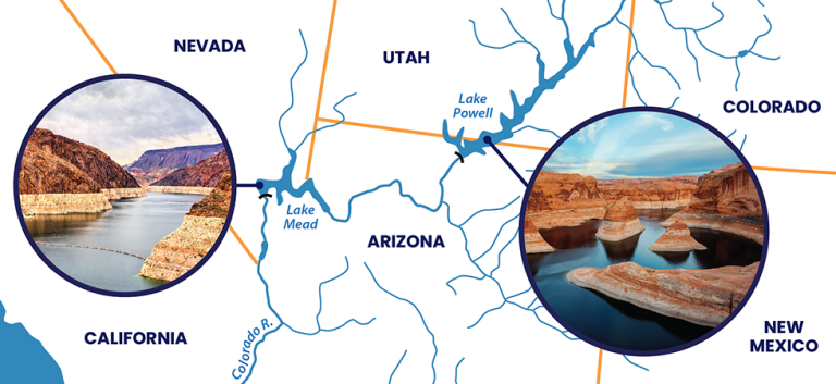
Incentives matter, especially in a system of free enterprise with purchasable and transferable water rights. Prior to the signing of the Colorado River Drought Contingency Plan in 2019, sovereigns and water users in the Upper Basin of the Colorado River actually faced a structural disincentive to conserve water. Firmly in the grips of aridification where demand outstrips supply, how could this be? In addition to Mark Felt’s (aka Deep Throat) advice to “follow the money” in the US West, it also pays to “follow the water.” Following the water here brings us to the two largest reservoirs in the United States: the Upper Basin’s insurance policy, Lake Powell, and the Lower Basin’s bank account, Lake Mead.

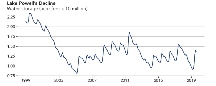
Lake Mead and Lake Powell are the two largest human-made reservoirs in the United States. Lake Mead’s capacity is 28,229,730 acre-feet and Lake Powell can hold 26,215,000 acre-feet of water, with a combined capacity of 54,444,730 acre-feet. At the current average inflow to the river (12,500,000 acre- feet), these two reservoirs could hold four years, four months’ worth of the river’s flow. As such, we have an abundance of water storage infrastructure, which means our Colorado River challenge is a water management challenge.

Any water in the Upper Basin conserved prior to 2019 was deemed “system water” the moment ithit Lake Powell. Colorado River system water is the water used to determine releases from Lake Powell, through the Grand Canyon, to Lake Mead. Because water conserved in the Upper Basin had no special designation, any water that made it to Lake Powell was used to calculate the releases and, therefore, could actually trigger a larger release of water from Lake Powell.

Negotiations

Faced with the threat of increasing aridification, the seven basin states and the federal government commenced emergency river management talks in 2017. Projections for Lake Powell and Lake Mead were alarming and showed that mere reliance on the operations policies then in place could bankrupt both reservoirs well in advance of the 2026 deadline for replacement criteria. (Interim Guidelines, 2007).

Lower Basin Situation

The Upper Basin had long criticized the Lower Basin’s water use that withdrew more water than flows into the system on an annual basis. The Upper Basin referred to this imbalance as “the structural deficit.” Furthermore, for reasons too involved to review in detail here, the Lower Basin states were facing their own disincentives to bank water in Lake Mead. California, the largest user in the Lower Basin, wanted assurances that Arizona would refrain from ordering the release of water the Golden Bear had banked in Lake Mead. Arizona, on the other hand, felt compelled to order the release of its entire legal apportionment from Lake Mead because of its junior priority on the river (the junior priority was the sacrifice Arizona was required to make to gain congressional approval of the Central Arizona Project). The stage was set for negotiations that would determine whether terms could be reached. The Lower Basin’s saga deserves its own article and I will not test your patience with it here.

Upper Basin Situation

The Upper Basin sovereigns sought more control over their shared destiny, especially given the entrenched nature and size of the structural deficit in the Lower Basin. Indeed, one of the reasons the system had not dropped even more quickly was because actual consumptive use in the Upper Basin failed, annually, to keep up with projections of greater water use. (Wheeler, 2021). Therefore, more water was showing up at Lake Powell, for subsequent release to Lake Mead, than the models predicted. This “extra” water in the system masked the real impact and rate of climate change. The true disruptive potential, however, of climate change would not remain hidden. The Lower Basin’s structural deficit was so great that, even with the Upper Basin already on a physically imposed water diet, the reservoirs continued to fall. Something had to be done.

Due to political, practical, and temporal realities, any immediate solution would need to work within the existing Law of the River. For one thing, the need to act quickly was incompatible with the lengthy environmental review processes typically required when making fundamental changes to existing management policy. In an attempt to avoid legal and practical crises on the river, Upper Basin interests began discussing two concepts: 1) operation of the initial units of the Colorado River Storage Project (Flaming Gorge, Aspinall, and Navajo reservoirs) to allow releases of water to address critical Lake Powell levels; and 2) creation of a safe harbor that would allow water users to voluntarily manage their demands and send conserved water to Lake Powell, free from the threat that the volume of conserved water would trigger larger releases of water to Lake Mead.

Colorado River Drought Contingency Plan

Over the course of 2018, the Upper Basin and Lower Basin concepts were discussed, debated, and eventually agreed to by the seven states and federal agency representatives. After much intrastate and interstate wrangling, the most recent addition to the Law of the River was settled on in a suite of agreements collectively known as the Colorado River Drought Contingency Plan (Contingency Plan or DCP). See Article, TWR #182 & Bovee, TWR #201. The states further agreed to pursue federal legislation directing the Secretary of the Interior to sign and implement the Contingency Plan agreements upon execution by the parties. On March 19, 2019, the Basin States wrote a letter to the US Congress requesting this legislation. In transmitting suggested legislative language, the Basin States noted that, much like the Contingency Plan itself, the language was “the product of collaboration and compromise” and that the Contingency Plan “will enhance existing water management tools in order to address a looming water crisis in the Colorado River Basin.” (Contingency Plan, Attachment C). The states also stressed the urgency of the situation, “[i]t is the position of the Basin States, and water contractors within those states, that immediately enacting the proposed federal legislation and implementing the [Contingency Plan] reduces the probability that Lakes Powell and Mead will decline to critically low elevations — which could occur as early as 2021 — and promotes both domestic and binational participation in drought contingency planning.” (Contingency Plan, Attachment C).

When asked what the Law of the River means, many Colorado River negotiators quip, “whatever the seven states say it means.” The retort proved true when, in an exceptionally polarized Congress, passage of the requested legislation occurred on April 8, 2019, a mere twenty days after the states submitted their request.

The Contingency Plan consists of an umbrella “Companion Agreement” (officially titled “Agreement Concerning Colorado River Drought Contingency Management and Operations”) and the following appended agreements:

• “Agreement for Drought Response Operations at the Initial Units of the Colorado River Storage Project Act”
• “Agreement regarding Storage at Colorado River Storage Project Act Reservoirs under an Upper Basin Demand Management Program”
• “Lower Basin Drought Contingency Plan Agreement”
Exhibit 1: “Lower Basin Drought Contingency Operations”
Appendix 1: “Table of Extraordinary Conservation (EC) ICS available as of the
Effective Date, in accordance with Section IV.A.1 of the LBOps”
• “Proposed Legislation” (Contingency Plan, 2019).

Responsive Operations of Reservoirs above Lake Powell

The first agreement directs and authorizes the Secretary of the Interior to operate the Colorado River Storage Project Act reservoirs (Flaming Gorge, Aspinall, Navajo) to protect the Lake Powell “Target Elevation” of 3,525 feet above mean sea level. This includes the authority to take emergency action at these reservoirs. Unless the parties agree otherwise, this agreement terminates on December 31, 2025. (Contingency Plan, Attachment A1).

Demand Management

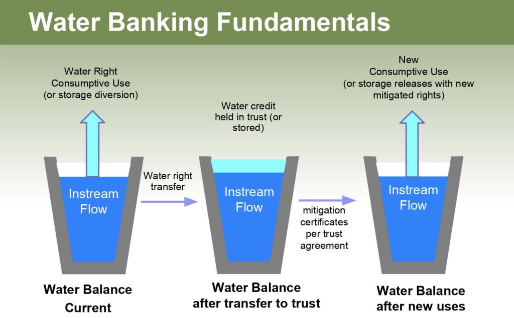
The second agreement authorizes the Secretary of the Interior to create an account “available for use by the Upper Division States” not subject to release or used to “cause a different release from Lake Powell than would have otherwise occurred under” the 2007 [Guidelines] or post 2026 operational rules.”

(Contingency Plan, Attachment A2). The agreement describes the four steps for approval of the Upper Basin Demand Management Program:

• First, the Upper Colorado River Commission makes findings that Demand Management is necessary.
• Second, the Upper Basin States and the Secretary of the Interior agree on the methodology, process and documentation for verification and accounting for Demand Management water.
• Third, the Upper Colorado River Commission approves of the Program.
• Finally, each Upper Basin State representative on the Upper Colorado River Commission approves the Program. (Contingency Plan, Attachment A2).

Whether or not the Law of the River is fundamentally altered under some alternative management paradigm, Demand Management is critical to the future of the Colorado River. The Contingency Plan recognizes this importance by allowing the concept of Demand Management to survive termination of the Contingency Plan through 2057. (Contingency Plan, Attachment A2).

Account Holders in Lake Powell: Sovereigns and Sovereigns Only

In describing the Demand Management account, the obvious is clear: sovereigns and only sovereigns are capable of holding water accounts in Lake Powell. At no point in the Basin States’ contingency plan negotiations did Colorado or any other state voice support for any entity other than a sovereign holding water in the Demand Management account in Lake Powell. The signatories to the Colorado River Contingency Plan Demand Management Agreement were all signing on behalf of sovereigns and sovereigns only. (Contingency Plan, Attachment A2). Moreover, not only would private accounts held by non-sovereigns be inconsistent with the Demand Management agreement and approvals described above, but such accounts could also undermine the benefit of the bargain Colorado and the other Upper Basin States negotiated in 1922. This is because the mere existence of those accounts would move substantially closer to Upper Basin to Lower Basin transfers of water. Such transfers would fly in the face of the benefit of the bargain the Upper Basin States negotiated to use water at their own pace (as opposed to engaging in a race to develop prior appropriation rights that the Lower Basin had already won). Sovereigns and only sovereigns are or should be capable of holding water in Lake Powell. The role of a sovereign here is to design a program that encourages the participation of its non-sovereign water users (e.g. private individuals and businesses, special water districts, municipal water providers).

Post-Contingency Plan programs reserved to the states

Belying the pending crisis, the Upper Basin has yet to take even the first of the four steps required for Demand Management program approval. While the signatory states created the Demand Management account upon approval by Congress and execution by the Upper Basin States, the negotiators intentionally reserved the design and detail of programs that would populate the account to the individual sovereign states.

While the Demand Management account now exists, it sits empty heading into yet another year of aridification. As of this writing, no state has approved a program to populate the account with water. Colorado, the state with both the largest contribution of water to the Colorado River, the largest Upper Basin apportionment, and the state where the discussion has been most involved to date, has yet to determine whether any program is feasible, achievable, worthwhile, or advisable. (CWCB, 2020).

The analogy of skydiving is apt. Thanks to the Contingency Plan, we now have a two-parachute rig strapped to our collective back. One parachute represents our ability to release water from reservoirs above Lake Powell to slow our descent. (Contingency Plan, Attachment A1). The second is Demand Management. (Contingency Plan, Attachment A2). The ground is quickly approaching. We can argue about the color of the second chute until it is too late, or we can pull the ripcord and start focusing on landing as safely as possible.

Our pace on achieving the four approvals must accelerate considerably in order for the second parachute to deploy in time. In the words of NASA Flight Director Gene Kranz, failure is not an option. Demand Management, alone, may prove insufficient to keep Lake Powell above the Target Elevation but we simply must deploy it to help arrest our descent. Making the decision to “go” requires leadership. Director Kranz speaks to this as well: “Leadership is fragile. It is more a matter of mind and heart than resources.” (Kranz, 2000). Without courageous leadership, a perfectly good parachute will remain, useless, in our pack and our hard-won Demand Management account will continue to sit empty.

Demand Management Benefits

Colorado River Demand Management has the potential to benefit all water users, the environment, and regional economies. With the creation of the Demand Management account, the Upper Basin States have, for the first time, an incentive to encourage water users to conserve water for banking in Lake Powell. Moreover, because the account exists until at least 2057, this incentive does not depend on any facet of the Law of the River changing or remaining static.

The Demand Management Storage Agreement provides a path to compensated, voluntary, temporary payments for conserved water. Should Upper Basin uses have to be reduced for any reason, Demand Management is a way to effectuate that reduction in a manner that best avoids “buy-and-dry.” (Colorado’s Water Plan, 2015). Demand Management can help facilitate alternatives to buy-and-dry that keep water rights permanently tied to production agriculture, thereby helping increase food security.

Demand Management can also assist with streamflow restoration. Conserved water flowing to Lake Powell might be timed to maximize the benefit to endangered fish species and critical habitat in the Upper Basin. Fortunately, the decline of the Colorado River is coinciding with evolving environmental science that helps quantify the benefits when water is left in a river. (Szeptycki, 2018). These benefits can be quantified and monetized to benefit water users trying to decide whether to consume their water or to leave it in the river in a given year.

Downstream of Lake Powell, scientific analysis shows environmental benefits and detriments to both native and non-native fish species below Lake Powell depending on its contents. (Rosenberg, 2021). Cooler water temperatures result when reservoir contents are higher while warmer water is the product
of lower water levels in reservoirs. While native fish may prefer warmer water temperatures from a drawn down Lake Powell, “they may also face invasion by warm water non-natives from Lake Mead.” (Rosenberg, 2021). The “best strategy is an intermediate strategy, where you have water that’s not too hot and not too cold…where you can still provide thermal conditions that are conducive to growth of native fish.” (Dibble, 2021). Demand Management water in the Colorado River System can make it easier to hit this “Goldilocks Zone” where reservoir releases are neither too hot nor too cold.

An Urgent Call to Action

While you have been reading this article, our continued, collective skydive has brought us that much closer to an unacceptable, and unpleasant, reunion with the ground. Simple physics demands we act. Two recent studies underscore the fact that managing Upper Basin demands is critical to addressing the decline of the Colorado River. (Wheeler, 2021; Miller, 2021). One argues that “[e]quitable demand reductions will be an important part of water management in the Colorado River basin in the era of climate change.” (Wheeler, 2021). A Demand Management program appears to be the most equitable and beneficial method for reducing demands without accelerating the buy-and-dry of irrigated agriculture.

Livelihoods, cultures, economies, food production, and environments are inextricably linked to the Colorado River. As such, sovereigns should involve both public and private sectors in making the next round of macro and micro water management decisions. The science seems clear that Colorado River management moving forward also requires more than a mere tweak here or there to the 2007 Guidelines for river operations. The fundamental tenants of interstate water management are overdue for a serious reevaluation. One part of the basin bearing the vast majority of climate change risk and reality is neither equitable nor sustainable. Moreover, to use a basketball analogy, the clock is not our friend. We are playing from behind and do not have the luxury of waiting until 2026 to adopt new water management policy.

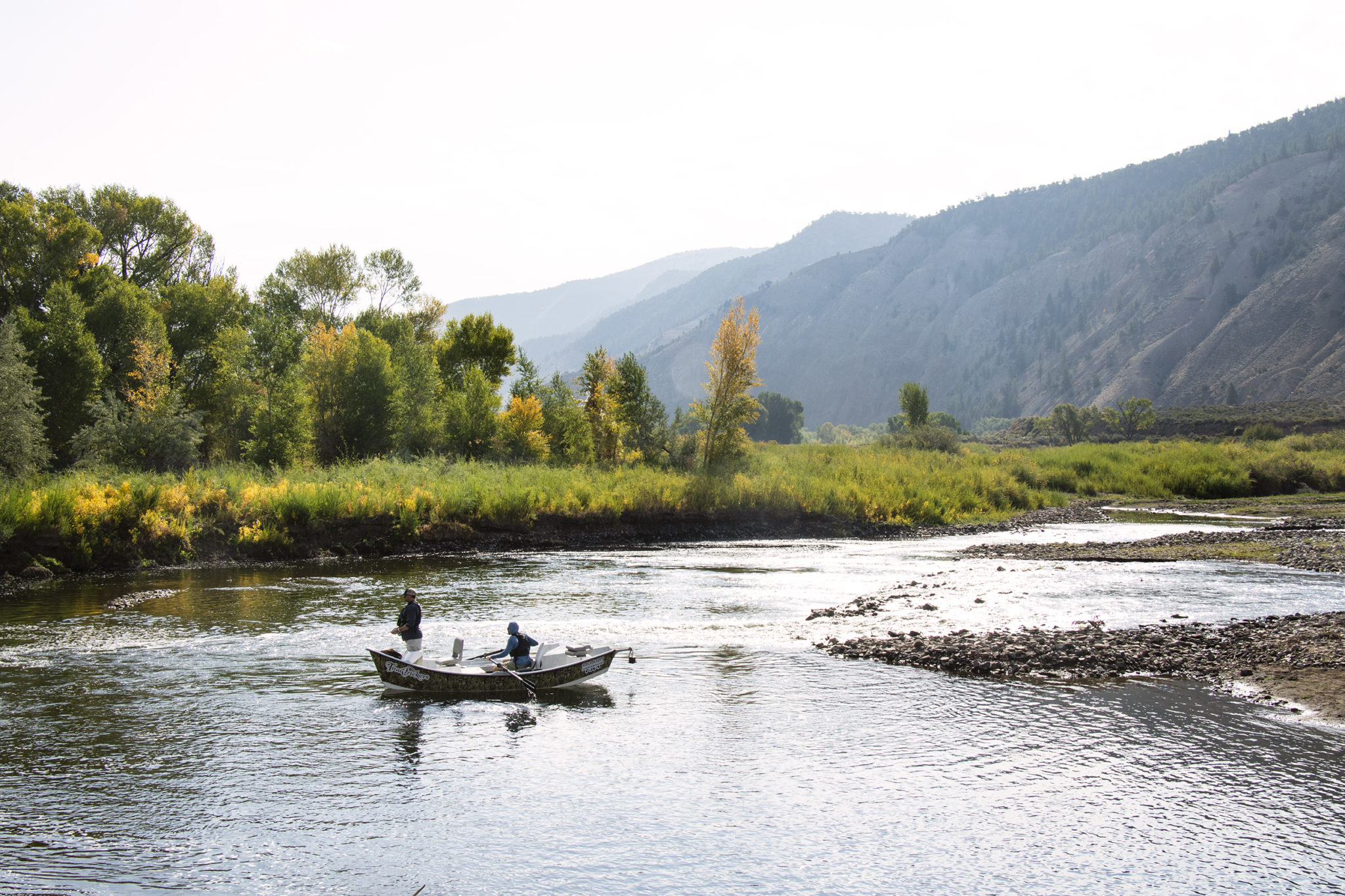
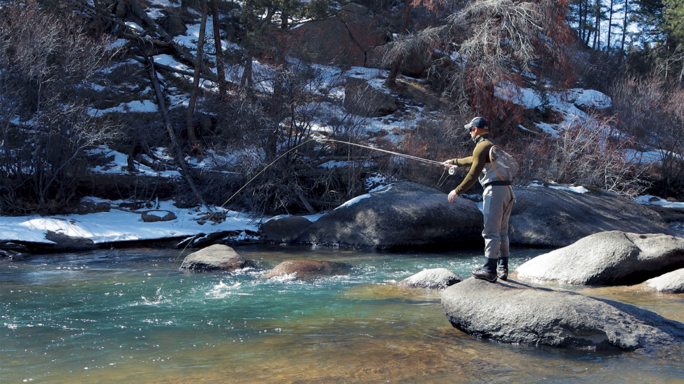
Each stakeholder on the Colorado River has an important role to play and Demand Management can facilitate their involvement. By now, you probably have a sense of the roles that federal, tribal, interstate, state, and local governments play on the Colorado River. Less often discussed is the role of the private sector. Importantly, private, for-profit interests include farmers and ranchers, rafting guides and flyfishing outfitters, main street businesses, and professional services industries. Given the scope and urgency of the challenge, excluding or vilifying stakeholders wastes precious time — time better spent cultivating and encouraging new water management ideas, innovation, and expertise from stakeholders from all sectors for the benefit of the Colorado River basin. (Ryder Howe, 2021). Providing agricultural producers access to capital in ways that avoid buy-and-dry and de-risk production is also important.

Conclusion

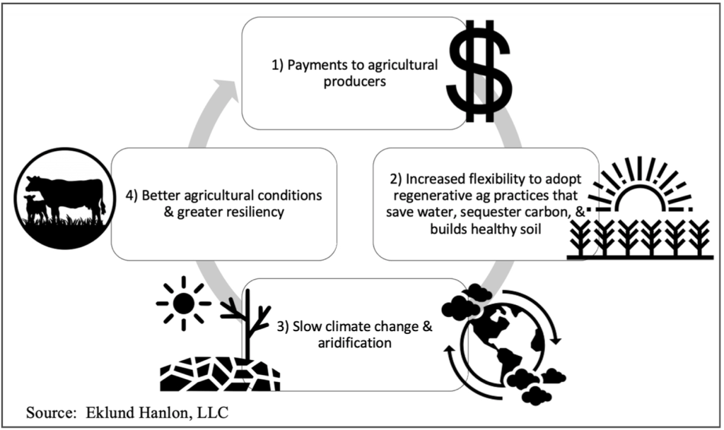
The sovereigns in the Colorado River basin should move quickly to make effective, efficient, equitable, and holistic management decisions in response to climate change. Demand Management has the potential to encourage conservation, innovation, and collaboration. Allowing agricultural producers greater flexibility and options encourages regenerative agricultural practices that could help address climate change. Compensating Upper Basin water users for leaving water in the river is a critical tool currently available to us by virtue of the Contingency Plan and can help us control the system’s descent. Upper Basin ranches like Mary and Ole Gunderson’s and those on Ute Tribal lands, stand a chance of not only still being in active production but thriving and contributing to the solutions that save the Colorado River. In summary, effective and efficient Demand Management could jumpstart a different cycle: 1) money is paid to agricultural water users for temporarily leaving their water in the river; 2) the increased flexibility this capital provides producers increases their ability to adopt regenerative agricultural practices that save water, sequester carbon, and regenerates healthy soil; 3) regenerative practices help slow climate change and aridification; 4) slowing climate change and aridification results in better agricultural conditions and greater resiliency; and 5) a stronger agricultural sector increases yields and nutrient content that results in more money for producers.
for additional information:

James Eklund, Eklund Hanlon LLC, 720/ 280-1835, james@eklundhanlon.com

#LakeMead likely to drop below elevation 1,040 by late 2023 — John Fleck #ColoradoRiver #COriver #aridification

Graphic credit: USBR

Last week John Fleck took a look at the April 15, 2021 Colorado Basin River Forecast Center’s 24-Month Study. Click here to read the post. Here’s an excerpt:

I’m choosing my words carefully here. The “likely” in this blog’s post’s title means “based on my analysis of the Bureau of Reclamation’s current ‘most probable forecast’ Colorado River water supply model runs.”

The Bureau’s current “most probable” modeling suggests that in both 2022 and 2023, the annual release from Lake Powell will only be 7.48 million acre feet. This is based on a provision in the river’s operating rules that, under certain low storage level conditions, the Upper Basin gets to hang onto water in Powell.

The last time and only time we had a 7.48 release, in 2014, Mead dropped 25 feet in a single year. We’ve never had two consecutive 7.48 releases.

The headline in yesterday’s release of the Bureau of Reclamation’s “24-month study” (pdf here) is that Lake Mead will drop below elevation 1,075 at the start of 2022 (triggering a “Tier 1” shortage) and could drop below 1,050 by the start of 2023 (that’s the trigger for “Tier 2”).

Tier 1 next year, which primarily hits Arizona with some deep forced reductions, was no surprise. That’s been obvious for a while, and Arizona’s water leadership has been softening folks up for months. The increasing risk of Tier 2 in 2023, which would mean deeper cuts in Arizona, is sorta new, but it’s been foreseeable.

The real “holy shit” for me in yesterday’s release was the trail of breadcrumbs in the Bureau’s data, pointed out by my co-author Eric Kuhn, leading to a “most probable” Lake Mead drop to elevation 1,035 by the end of September 2023.

To be clear, the Bureau isn’t saying this yet. The latest 24-month study stops at the end of March 2023. But internally, the Bureau runs the model out farther in order to determine, among other things, how much water is likely to be released from Powell in 2023. And the published numbers clearly show – the Bureau’s “most likely” scenario would call for another 7.48 release.

From there, it’s just arithmetic. Based on my analysis of the publicly available numbers, the “most likely” scenario puts Mead at elevation ~1035 at the end of September 2023. This is my math, but my understanding is that it’s consistent with what the Bureau’s internal calculations show.

Lake Powell is seen in a November 2019 aerial photo from the nonprofit EcoFlight. Keeping enough water in the reservoir to support downstream users in Arizona, Nevada and California is complicated by climate change, as well as projections that the upper basin states of Colorado, Utah, Wyoming and New Mexico will use as much as 40% more water than current demand. A recent white paper from a lineup of river experts calls those use projections into question.
CREDIT: ECOFLIGHT via Aspen Journalism

Eric Kuhn followed up John’s post with one of his own. Here’s an excerpt:

The release of last week’s Bureau of Reclamation 24-month study felt like very bad news for the Colorado River (See Tony Davis for details.). But a careful reading of the numbers, and an understanding of the process through which they are developed, suggests things are likely even worse than the top-line numbers in the study.

The problem: the assumptions underlying the study do not fully capture the climate-change driven aridification of the Colorado River Basin. Taking climate change into account, it is easy to find evidence lurking in the report to suggest that, in addition to problems for Lake Mead, Lake Powell could drop below elevation 3,525 in 2023, a level that is troublingly close to the elevation at which Glen Canyon Dam could no longer generate hydropower.

The 24-month studies are used to project out two years of monthly inflows, releases, storage levels, and power generation from the system’s large reservoirs in both basins as well as diversions by the large water users on the river below Lake Mead, especially the Central Arizona Project and the Metropolitan Water District of Southern California. Reclamation releases a “most probable” study on a monthly basis as well as “minimum probable” and “maximum probable” studies approximately quarterly. These studies are important because they are used to make critical decisions under the 2007 Interim Guidelines and both the Upper and Lower Basin Drought Contingency Plans (DCPs).

For the first year, Reclamation uses “unregulated” runoff forecasts generated by the Colorado Basin River Forecast Center (CBRFC) model. Unregulated inflow is not the same as natural inflow. The CBRFC does its best to adjust the forecasts for upstream diversions and for the many reservoirs that are not included in the 24-month study model. Inflow forecasts for the second year of the 24-month studies are not based on the CBRFC model. Instead, Reclamation, in consultation with CBRFC, uses statistics from the past and its judgment. Running the 24-month study model then simulates the operation of the upstream reservoirs such as Navajo, Blue Mesa, and Flaming Gorge, turning unregulated inflow to Powell into “regulated” inflow. For example, from the April ‘21 most probable study, the WY 2021 unregulated inflow to Powell is 4.897 MAF, regulated inflow is 4.908 MAF. These numbers are close, but in WY 2020 regulated inflow exceeded unregulated inflow by about 700,000 acre-feet.

The media buzz over the April 24-month study primarily focused on the projected Tier 1 shortage for the Lower Basin in 2022 – an event that is newsworthy, but one that also was totally expected. Perhaps more interesting and alarming is what the 24-month studies suggested for 2023. As pointed out by John in his recent blog, the most probable study shows two years of 7.48 MAF releases from Lake Powell, Lake Mead elevations on the cusp of a Tier 2 shortage in 2023, and by inference, Lake Mead dropping to a level of about 1035’ by the end September 2023, which by implication would trigger a third straight shortage year and California’s possible participation sharing shortages under the Lower Basin DCP.

For Lake Powell, the most alarming results come from the minimum probable study, not the most probable study. Under the minimum probable inflow forecast to Powell, which, in theory, represents an unregulated flow that would be exceeded in 90% of years, by March of 2023 Lake Powell drops well below the 3525’ target that would trigger supplemental releases from the upstream CRSP reservoirs under the Upper Basin DCP. There is also a real possibility that Lake Powell could end up in the Lower Elevation Balancing Tier. If this happens, the April minimum probable study shows that Lake Mead gets more water in the first six months of WY 2023 than under the most probable study.

The term “minimum probable” implies an outcome that is very unlikely to occur, therefore, why should we be that concerned? My answer is that given the abundance of recent science concluding that the Colorado River Basin is not in a classic drought, but rather, it is undergoing aridification where the flows seen in the last two to three decades may be the new abnormal and may continue to decline (see for example Overpeck and Udall, and the latest Utah State Future of the Colorado River white paper White Paper). The April studies show a most probable Powell unregulated inflow for WY 2022 of 9.998 MAF and a minimum probable inflow of 7.208 MAF. For comparison, the mean unregulated annual inflow to Lake Powell over the last ten years, including WY 2021, was only 8.04 MAF and five of the individual years; 2012, 2013, 2018, 2020, and 2021, were well below the 7.208 MAF. The average of those five dry years was 5.08 MAF, over two MAF less than the assumed minimum probable inflow for 2022. If you take the record back to 2000, the results are similar. In 11 of 22 years, unregulated inflow to Lake Powell was less than 7.2 MAF/year.

Based on the last 20-plus years and the recent science, I conclude that both the minimum probable and most probable 24-month study year two unregulated inflows to Lake Powell are overly optimistic. The likelihood that in the next few years Lake Powell storage will fall below the 3525’ target or even the minimum power elevation (3490’) and that Lake Mead storage will approach 1025’, the level that triggers the maximum annual cutbacks under the Interim Guidelines and DCP, about 1.4 MAF, is much greater than what is conveyed by these studies.

In a photo from 2020, a distinct line around the rocky shore shows how much the water level has decreased in Nevada’s Lake Mead. Mead is expected to drop 15 feet in 2021 Photo credit: Roberto (Bear) Guerra/High Country News

Finally, Click here to read Tony Davis’ article at Tucson.com. Here’s an excerpt:

The Central Arizona Project seems almost certain to suffer its first significant shortage in water deliveries next year.

Reservoirs are expected to fall so low by the end of 2021 to warrant cutting nearly two-thirds of the CAP water that Pinal County farmers now get. At that point, CAP deliveries used by the state to store water in the ground for future use by cities and tribes would also be cut. So would CAP water supplies sold to the Central Arizona Groundwater Replenishment District, an agency that recharges water into aquifers across the state’s urban centers to compensate for groundwater pumped elsewhere for new development.

The loss for farms has been expected for years. But possible cuts for other water customers now loom sooner than anticipated, as the Colorado River’s situation worsens.

For the first time, a federal agency’s river forecast predicts that at the end of 2022, the Lake Mead reservoir will be at or very near a point where CAP must cut deliveries to other categories of water users.

Those cuts would fall upon Phoenix-area cities and on Arizona tribes, including possibly the Tohono O’Odham whose reservation is south and west of Tucson.

If they happen, the cuts would also start slicing deliveries of relatively small amounts of CAP water to Rosemont Copper and Freeport McMoran Copper in the Tucson area and to Resolution Copper in the Superior area.

Tucson depends on CAP for drinking water, but its supplies wouldn’t yet be affected.

The cuts to farmers will be required if Lake Mead falls below 1,075 feet at the end of this year. The Bureau of Reclamation’s new forecast — announced Thursday for the river — puts the expected level at 1,067 feet by then. The bureau will likely decide in August whether to declare a shortage for 2022.

The additional cuts to tribes and to Phoenix-area cities would be required in 2023, if Lake Mead falls below 1,050 feet. The new forecast is for the lake to be at 1,050.31 feet by December 2022.

Tucson’s CAP supply wouldn’t be cut unless the lake fell below 1,025 feet.

It’s not #drought, but what do we call it? — The Mountain Town News #aridification #ColoradoRiver #COriver

Lake Mead was about 40% full in December 2019, but will almost certainly fall further this year, as will its companion reservoir of the desert southwest, Lake Powell. Photo/Allen Best

From The Mountain Town News (Allen Best):

We need a word that better captures what’s happening in the Colorado River Basin

Big Pivots

In New Mexico last week, a couple in Santa Fe was weighing whether to build a house on the 20-acre lot they had purchased. Among the questions perplexing them was how the warming and drying climate might marginalize their asset.

Relatively few people were asking such questions a decade ago. Now they are. Most people remain more concerned about making the next mortgage payment or a dozen other concerns, but climate change has ceased to be a future worry. It’s right outside the door, evident in the rising heat, the larger and more frequent wildfires, and the news of broader and exceptional “drought.”

One aspect of the warming that has been widely if mostly anecdotally observed has been the melting of snow in winter months. Less snow has been making it to spring—and that means less water flowing in rivers come summer.

“New paper out on widespread increased snow melt during the winter in the US West by well-known scientists,” tweeted Brad Udall, who is himself something of a well-known climate and water scientist affiliated with Colorado State University.

“These papers never have good news, alas. Meanwhile #coloradoriver runoff currently forecast at 45% despite 80% snowpack.”

In the paper, “Winter melt trends portend widespread declines in snow water resources,” four researchers—three from Colorado—compared records of 1,065 snow-measurement stations in the West between the Mexico border and continuing northward into the Alaskan Arctic since the 1970s.

The snow-water equivalent is measured at a site in January. Photo/Natural Resources Conservation Service via The Mountain Town News

Melting before April 1 has increased at almost half of the stations by an average 3.5% per decade.

This so-called winter melting has been most prominent in November and March, although it has occurred in all months, they say in the paper published in Nature Climate Change.

“Historically, water managers use the date of April 1 to distinguish between winter and spring, but this distinction is becoming increasingly blurred as melt increases during the winter,” said Noah Molotch, a study co-author and associate professor of geography and fellow at INSTAAR.

The mountains have often been described as the water tower of the West, akin to the tanks that stand over many small communities. The snow melts rapidly during spring, of course, but then slowly melts well into summer. Now, there’s less snow to melt. The tank on the hill has less water.

“That slow trickle of meltwater that reliably occurs over the dry season is something that we have built our entire water infrastructure on in the West,” Keith Musselman, of the Institute of Arctic and Alpine Research, told CU Boulder Today, an arm of the University of Colorado.

This causes my mind to wander to the Colorado mountain town of Red Cliff, a place of roughly 300 people located at an elevation of 8,600 feet not far from the Continental Divide. One of the life-time residents there, a “powder man” in several of the local mines, observed that the snowpack normally grew until St. Patrick’s Day, then began to shrink. The snow depth could rise again with new snow, but only temporarily. With warming winters, I wonder when the snowpack at Red Cliff now ceases to rise. Might it now be early March?

This is from the April 18, 2021, issue of Big Pivots. For a free subscription, go to http://BigPivots.com

Authors of the new study point out that this shift in melting could affect wildfire season and agriculture irrigation needs. They also note that their findings are consistent with what climate models suggest will continue to happen.

One feature of this incremental warming has been early runoff, with peaks roughly two weeks earlier in this century.

In Steamboat Springs, the Pilot reported on April 7 that the snow-water equivalent going into April stood at 14.5 inches, according to the Natural Resources Conservation Service. If that stays as the peak, the 2020-21 winter will have peaked seven days earlier and with about 3.4 inches less water than the 30-year median peak. “The thawing has begun earlier than we would like,” said Kelly Romero-Heaney, the water resource manager for the city of Steamboat Springs.

During the 1983 Colorado River flood, described by some as an example of a “black swan” event, sheets of plywood (visible just above the steel barrier) were installed to prevent Glen Canyon Dam from overflowing. Source: Bureau of Reclamation

Maybe it will snow in May—a lot. I remember the spring of 1983 when I was working in Winter Park. A a so-so ski season was followed by an exceptional spring. We barely saw the sun. It seemed to snow every day. And then when the snow melted, the gush took water managers downstream at Glen Canyon Dam by surprise, almost toppling that massive plug that creates the playground of Lake Powell.

Now Powell and its companion behemoth in the desert Southwest, Lake Mead, have struggled in the 21st century. The two reservoirs, largest in America, have a capacity for 54.5 million acre-feet. They’re not close to half full—and they’re likely to decline more this year. Too many years have been like 2020.

Nearly all the water flowing in the Colorado River originates in the headwater states, most of all Colorado, and mostly as snow. In 2020, the snowpack in the upper basin was 114% of average. That snowpack yielded only 55% of average runoff.

Let’s wrap our minds around those numbers again: snowpack 114% of average and runoff 55% of average. Wow.

A rivulet along the Colorado River near Granby, Colo., on April 2, the Indian Peaks component of the Continental Divide in the background. Photo/Allen Best

This year, the snowpack is nowhere near as good. “Current conditions resemble 2002, 2012, and 2013 and the beginning of 2018, four of the five driest years on record,” said the Bureau of Reclamation in an April 15 report. As Udall noted in his tweet, the Bureau projects flows 45% of average into Powell.

As KUNC and other news outlets have reported, this marginal runoff will almost certainly mean that water levels in Lake Mead, the reservoir outside Las Vegas, will drop below the critical threshold of 1,075 feet. As per an agreement among the seven states in the Colorado River Basin in 2019 and also Mexico, this means there will be further cuts in deliveries to Arizona, Nevada, and Mexico. California could also see its river allocation restricted if the declines continue.

Have Colorado and other states in the Southwest come to terms with the new reality? Yes—and no. A bit of history is worth visiting.

Eric Kuhn and John Fleck, in “Science Be Dammed: How Ignoring Inconvenient Science Drained the Colorado River,” demonstrated how willfully those who created the framework of compacts and water-delivery infrastructure in the Colorado River ignored available evidence that the river might not well deliver the quantities they wanted to assume. They assumed upwards of 20 million acre-feet. In fact, in the 21st century, the river has been delivering an average 12.5 million.

The science that framers of the Colorado River Compact ignored when they gathered in Santa Fe in 1922 was that of substantial periods of lesser flows in the 19th century. Congress had better evidence yet—but again ignored it when approving the compact in 1929.

Further scientific research has yielded confirmation of decades-long periods of low flows, the megadroughts of a thousand years ago.

See my 2020 review of this book.

Not until the 1960s was there a grudging appreciation for limits. And not until 2007 was there more explicit acknowledgment of the need for revised assumptions.

We’re now in the midst of that acknowledgement. In the 2019 agreement among the basin states, commonly called the “Drought Contingency Plan,” Arizona took the biggest cut, but California got creative, too. That agreement might just as easily have been called the “Buying Time Agreement,” because that is essentially what it did, providing interim measures while a greater vision was assembled to be implemented in 2026. Work is just now beginning on that next iteration.

In 2019, when I interviewed Udall, he said he objected to the word “drought” in the title of the plan. It suggests a temporary condition. He and others have been producing evidence that roughly half the runoff decline has been the result of warming caused by accumulated greenhouse gases. The higher temperatures result in increased evaporation, sublimation, and transpiration. Other researchers have reached much the same conclusion. In a 2019 paper, Udall and Jonathan Overpeck chose to call it a “hot drought.”

Brad Udall: Here’s the latest version of my 4-Panel plot thru Water Year (Oct-Sep) of 2019 of the #coriver big reservoirs, natural flows, precipitation, and temperature. Data goes back or 1906 (or 1935 for reservoirs.) This updates previous work with @GreatLakesPeck

Others in the Colorado River Basin have similarly been parsing their vocabulary.

“The drying trend” is the new abnormal—it is not a drought,” Kuhn tweeted this morning.

James Eklund points to increasing temperatures of 1.5° F globally since his great-grandparents began ranching in western Colorado in 1888. Eklund, a former director of the Colorado Water Conservation Board, among other postings, uses the phrase “aridification,” the gradual change of a region from a wetter to a drier climate.

James Eklund, with his father Larry Eklund, on the family homestead in Western Colorado. Photo via Aspen Journalism.

He also coined a word, “spongeification,” in a 5,000-word essay published in the April 15 issue of The Water Report. By this, he means the process by which dry soils and depleted groundwater aquifers soak up the runoff that does materialize.

Eklund, in an e-mail, told me that he intentionally used the word drought sparingly “because we’re not in a drought (which implies that we might rebound next year).”

It had snowed hard in metro Denver the day he wrote me, and he made note of that snow (which wasn’t nearly so heavy in the Colorado River Basin).

“Despite the snow out the window (and thank heavens for it!), the water year in Colorado and in the Colorado River Basin is going to be challenging at best and perhaps seriously disruptive,” he wrote. “Despite all the coverage and hyperbole, I do not see the current water apparatus (of which I consider myself a part) moving quickly enough to confront the challenge climate change presents to our water systems.

Eklund’s essay makes the case for stepped up implementation of demand management, as I understand it, a way for ranchers and farmers in places like Colorado to lease their water. Whatever the techniques, there must be responses sufficient to the shifting climate.

Front yards in hot and water-short Albuquerque often have no grass. Photo/Allen Best

Then there is conservation. The Las Vegas Sun this week lent its cautious support for a bill in the Nevada Legislature that proposes to make removal of ornamental grass mandatory – not voluntary, a response to incentives, as has already resulted in the uprooting of more than 200 million square feet of grass lawns. If the only time we set foot on grass is to mow it, what real purpose does it serve?

I see a greater role for landscape architects in our future. Dumping gravel on a yard, one of the common solutions to water scarcity that I have seen in Las Vegas and Santa Fe – and, actually, in my own relatively verdant neighborhood in suburban Denver—just doesn’t cut it.

But back to drought, a word that falls short, at least given our current meaning of it. I think we need a better word or phrase that conveys what happens better than “drought.”

Once we can come up with a better word or phrase, we’ll more readily get to work on adaptations necessary with this shifting climate that will change and then change and change again.

Recommended reading:

Brad Udall and Jonathan Overpeck on “Climate change and the aridification of North America.”

Assistant Colorado climatologist Becky Bolinger assigns grades to the Colorado River Basin’s snowpack in The Washington Post.

Also, “Alternative Management Paradigms for the Future of the Colorado and Green Rivers.”

Willow Creek, at the headwaters of the Colorado River, on April 2. Photo/Allen Best

U.S.-China Joint Statement Addressing the #ClimateCrisis — @StateDept

Here’s the joint statement from the U.S. and China:

U.S. Special Presidential Envoy for Climate John Kerry and China Special Envoy for Climate Change Xie Zhenhua met in Shanghai on April 15 and 16, 2021, to discuss aspects of the climate crisis. At the conclusion of the discussion, the two Special Envoys released the following joint statement.

Begin text:

1. The United States and China are committed to cooperating with each other and with other countries to tackle the climate crisis, which must be addressed with the seriousness and urgency that it demands. This includes both enhancing their respective actions and cooperating in multilateral processes, including the United Nations Framework Convention on Climate Change and the Paris Agreement. Both countries recall their historic contribution to the development, adoption, signature, and entry into force of the Paris Agreement through their leadership and collaboration.

2. Moving forward, the United States and China are firmly committed to working together and with other Parties to strengthen implementation of the Paris Agreement. The two sides recall the Agreement’s aim in accordance with Article 2 to hold the global average temperature increase to well below 2 degrees C and to pursue efforts to limit it to 1.5 degrees C. In that regard, they are committed to pursuing such efforts, including by taking enhanced climate actions that raise ambition in the 2020s in the context of the Paris Agreement with the aim of keeping the above temperature limit within reach and cooperating to identify and address related challenges and opportunities.

3. Both countries look forward to the US-hosted Leaders Summit on Climate on April 22/23. They share the Summit’s goal of raising global climate ambition on mitigation, adaptation, and support on the road to COP 26 in Glasgow.

4. The United States and China will take other actions in the short term to further contribute to addressing the climate crisis:

  • a. Both countries intend to develop by COP 26 in Glasgow their respective long-term strategies aimed at net zero GHG emissions/carbon neutrality.
  • b. Both countries intend to take appropriate actions to maximize international investment and finance in support of the transition from carbon-intensive fossil fuel based energy to green, low-carbon and renewable energy in developing countries.
  • c. They will each implement the phasedown of hydrofluorocarbon production and consumption reflected in the Kigali Amendment to the Montreal Protocol.
  • 5. The United States and China will continue to discuss, both on the road to COP 26 and beyond, concrete actions in the 2020s to reduce emissions aimed at keeping the Paris Agreement-aligned temperature limit within reach, including:

  • a. Policies, measures, and technologies to decarbonize industry and power, including through circular economy, energy storage and grid reliability, CCUS, and green hydrogen;
  • b. Increased deployment of renewable energy;
  • c. Green and climate resilient agriculture;
  • d. Energy efficient buildings;
  • e. Green, low-carbon transportation;
  • f. Cooperation on addressing emissions of methane and other non-CO2 greenhouse gases;
  • g. Cooperation on addressing emissions from international civil aviation and maritime activities; and
  • h. Other near-term policies and measures, including with respect to reducing emissions from coal, oil, and gas
  • 6. The two sides will cooperate to promote a successful COP 26 in Glasgow, aiming to complete the implementation arrangements for the Paris Agreement (e.g., under Article 6 and Article 13) and to significantly advance global climate ambition on mitigation, adaptation, and support. They will further cooperate to promote a successful COP 15 of the Convention on Biological Diversity in Kunming, noting the importance of the post-2020 Global Biodiversity Framework, including its relevance to climate mitigation and adaptation.

    For media inquiries, please contact ClimateComms@state.gov.

    The Pagosa Area #Water and Sanitation District implements voluntary #drought restrictions — The #PagosaSprings Sun #SanJuanRiver #ColoradoRiver #COriver #aridification

    Colorado Drought Monitor April 13, 2021.

    From The Pagosa Springs Sun (Clayton Chaney and Randi Pierce):

    The Pagosa Area Water and Sanitation District (PAWSD) is asking water users to practice responsible water use, with the district currently in a voluntary drought stage in compliance with its 2020 Drought Management Plan.

    According to a press release from PAWSD District Manager Justin Ramsey, “The primary driver of this drought stage is the U.S. Drought Monitor (USDM),” which indicates that “our area is in a Severe to Extreme Drought.”

    Ramsey’s press release notes that Hatcher Lake is lower than the median volume for this time of year, “however the lake is currently filling.”

    “The flow of water in the San Juan is currently above the median flow for this time of year,” the press release further notes.

    Ramsey also noted in his press release that so far this spring Pagosa Country has seen higher-than-normal temperatures.

    He explained that the higher-than-normal temperatures combined with “a reduction in late spring precipitation will lead to a quicker-than-normal melting of the snowpack,” which will reduce the volume of available water and “could lead to water use restrictions.”

    According to the press release, there are no mandatory water use restrictions, “however PAWSD does encourage responsible water use.”

    […]

    River report

    According to the U.S. Geological Survey (USGS), the San Juan River was flowing at a rate of 606 cubic feet per second (cfs) in Pagosa Springs as of 10 p.m. on Tuesday, April 13.

    Based on 85 years of water records at this site, the average flow rate for this date is 514 cfs.

    The highest recorded rate for this date was in 1985 at 1,930 cfs. The lowest recorded rate was 120 cfs, recorded in 1977.

    As of 10 p.m. on Tuesday, April 13, the Piedra River near Arboles was flowing at a rate of 492 cfs. Based on 58 years of water re- cords at this site, the average flow rate for this date is 784 cfs.

    The highest recorded rate for this date was 2,600 cfs in 1985. The lowest recorded rate was 128 cfs in 1977.

    Westwide SNOTEL basin-filled map April 18, 2021 via the NRCS.

    Snow report

    According to the U.S. Department of Agriculture National Water and Climate Center’s snowpack report, the Wolf Creek summit, at 11,000 feet of elevation, had 33.8 inches of snow water equivalent as of 10 p.m. on April 13.

    That amount is 79 percent of the April 13 median for this site.

    The San Miguel, Dolores, Animas and San Juan River basins were at 61 percent of the April 13 median in terms of snowpack.

    @GreeleyWater: Dive into a look at the city’s water rights — The #Greeley Tribune

    Seaman Reservoir upstream of confluence of the North Fork of the Cache la Poudre River. Photo credit Greg Hobbs.

    From The Greeley Tribune (Trevor Reid):

    In the past year, Greeley officials purchased about 1,000 acre-feet of water, equivalent to about 1,000 football fields covered in a foot of water. Adam Jokerst, deputy director of water resources for the city, said it’s more water than city had acquired in the past 10 years. Jokerst, who manages the water acquisition program, said the program has about a $9 million budget this year…

    What is a water right?

    Colorado’s waters are owned by the state and all its citizens, but water rights dictate the right to use the water. Water decrees, issued by water courts, confirm water users’ rights to that water.

    Older water decrees were simple, Jokerst said, giving the example of a decree for the city’s senior direct rights, meaning the city has priority to divert water for direct application to beneficial use. Throughout the year, the city can use 12.5 cubic feet per second. That’s about it, he said.

    Newer decrees can range from dozens to hundreds of pages, detailing how the water is to be diverted, measured and accounted for.

    “Greeley owns a portfolio made up of many different water rights,” Jokerst said. “Some of those water rights are direct diversions from the Poudre River. Some are ownership in irrigation companies.”

    Irrigation companies that historically provided irrigation water to farmers can issue shares of stock, basically selling a piece of the water rights held by those companies. The city converts that water from agricultural to municipal use to change the water right, though the city does rent some water rights to agricultural users, maintaining the historic use.

    The city also owns water through the Colorado-Big Thompson and Windy Gap projects, as well as water diverted from the Laramie River. With a lot of variability across these different sources, the city’s water experts always plan for the worst case scenario: How much water could we provide to our customers in a drought situation?

    Through the current plan, the city can provide about 40,000 acre-feet per year to its customers, well above the roughly 25,000 acre-feet of demand the city sees in a typical year. In a wet year, the city could potentially deliver up to 70,000 acre-feet, to give an idea of the impact of the planned drought.

    When the city can, it rents a lot of that water to agricultural partners, renting about 20,000 acre-feet in the past year. In addition to maintaining historic use, this provides a source of revenue and supports Greeley’s agricultural economy, Jokerst said.

    Jokerst said he’d consider the city’s “Big Three” sources to be:

  • Senior direct rights from the Poudre River
  • Ownership in the Greeley-Loveland Irrigation Company, which feeds the city’s Boyd Lake System
  • Colorado-Big Thompson (C-BT) and Windy Gap projects
  • Jen Petrzelka, water resources operations manager, added the direct and C-BT water is available year round, whereas a lot of the ditch directs only come in during irrigation season, which typically starts about now to early May and runs through the end of September or into October.

    Accounting for the city’s diverse portfolio

    The city must account for its water on a daily basis, submitting a monthly report to the state. Petrzelka said they manage about 10 different spreadsheets for all the city’s water right decrees…

    Petrzelka keeps an eye on the city’s water supply to help prevent the need for watering restrictions. In all, the city has four engineers and scientists who manage the various decrees and operations, plus three workers out in the field, according to Jokerst.

    The state ensures water users aren’t causing injury to other users’ water rights, with local river commissioners dedicated throughout the state. Jokerst compared the commissioners to a referee in a sports game.

    “Any time we change the way we’re operating, whether that be our releases or operating an exchange, we have to get their approval,” Petrzelka said.

    When agricultural water rights are changed, Jokerst said, some water is owed back to the river, just as the water historically returned to the river and groundwater after agricultural use.

    “A lot of what we do is add water back to the river to compensate for those irrigation rights that we changed,” he said.

    In addition to enforcement by river commissioners, everybody watches their neighbors, keeping track of what other users are doing on a day-to-day basis. Part of that monitoring happens in water court, where decisions about decrees are settled…

    Greeley has a steady stream of water court cases the city must defend in court, according to Jokerst, as well as cases involving other entities in which the city enters opposition to protect its water rights. As of this past week, the city was involved in 32 water court cases.

    “Water court cases are really just a structured negotiation where the applicant and the opposers reach agreement on whatever it is the applicant is trying to do,” Jokerst said. “All the parties involved negotiate an outcome that protects all their water and gets the applicant what they need.”

    Petrzelka and Jokerst estimated the city’s water court costs at about $500,000 this year, mostly covering the costs of outside attorneys and engineers. Internal legal counsel also helps guide the department, Jokerst said.

    ‘We’re making progress’ — Navajo-Gallup Water Supply Project moves ahead on Navajo Nation — The #Farmington Daily Times #SanJuanRiver #ColoradoRiver #COriver #aridification

    Installing pipe along the Navajo-Gallup Water Supply Project. Photo credit: USBR

    From The Farmington Daily Times (Noel Lyn Smith):

    U.S. Bureau of Reclamation construction inspector Kenny Redhouse carefully watched crewmembers install a section of pipe in an area south of Newcomb on April 15 as construction continued on a pipeline that will eventually deliver San Juan River water to Gallup and communities on the Navajo Nation.

    The water will replace dwindling groundwater supplies and meet future demand…

    Project broke ground in 2012

    It was in June 2012 when then Secretary of the Interior Ken Salazar, former Navajo Nation President Joe Shirley Jr. and others broke ground for construction of the first phase of the Navajo-Gallup Water Supply Project.

    Almost a decade later, construction proceeds on the San Juan Lateral, the largest of two segments that comprise the project. This lateral will eventually pump water from the San Juan River near Waterflow then deliver it south to Gallup and to Navajo Nation chapters along the pipeline and that surrounds the city.

    As the lateral approaches Gallup, it branches east toward Crownpoint while another branch will serve Window Rock, Arizona, and areas along New Mexico Highway 264.

    The bureau marked in October the completion of the Cutter Lateral, which will deliver water to several chapters on the eastern side of the Navajo Nation and to the southwestern portion of the Jicarilla Apache Nation.

    Bart Deming, the project’s deputy construction engineer, said construction of the San Juan Lateral is about 50% complete…

    Seven more years of work

    The total cost of the project is about $1.5 billion, and the entire project will be operational in 2028, he said.

    It is not difficult to notice construction activities alongside U.S. Highway 491 in Newcomb and Sheep Springs.

    Rick Reese, field engineering division manager for the bureau’s Four Corners office, said sections of pipe near Burnham Junction, in Naschitti and portions of Newcomb have been installed within the last year and a half…

    The area of focus now is south of Newcomb into Sheep Springs.

    Completion on this portion of the lateral is on track to end in early 2022, Reese said…

    The bureau awarded in September 2020 a nearly $46 million contract to Archer Western Construction LCC of Phoenix to build the pumping plant and a second one in Twin Lakes.

    San Juan River Basin. Graphic credit Wikipedia.

    US West prepares for possible 1st #water shortage declaration — The Associated Press #ColoradoRiver #COriver #aridification

    At full pool, Lake Mead is the largest reservoir in the United States by volume, but two decades of drought have dramatically dropped the water level behind Hoover Dam as can be seen in this photo. (Source: U.S. Bureau of Reclamation)

    From The Associated Press (Sam Metz):

    The U.S. Bureau of Reclamation released 24-month projections this week forecasting that less Colorado River water will cascade down from the Rocky Mountains through Lake Powell and Lake Mead and into the arid deserts of the U.S. Southwest and the Gulf of California. Water levels in the two lakes are expected to plummet low enough for the agency to declare an official shortage for the first time, threatening the supply of Colorado River water that growing cities and farms rely on.

    It comes as climate change means less snowpack flows into the river and its tributaries, and hotter temperatures parch soil and cause more river water to evaporate as it streams through the drought-plagued American West.

    The agency’s models project Lake Mead will fall below 1,075 feet (328 meters) for the first time in June 2021. That’s the level that prompts a shortage declaration under agreements negotiated by seven states that rely on Colorado River water: Arizona, California, Colorado, Nevada, New Mexico, Utah and Wyoming.

    The April projections, however, will not have binding impact. Federal officials regularly issue long-term projections but use those released each August to make decisions about how to allocate river water. If projections don’t improve by then, the Bureau of Reclamation will declare a Level 1 shortage condition. The cuts would be implemented in January.

    Arizona, Nevada and Mexico have voluntarily given up water under a drought contingency plan for the river signed in 2019. A shortage declaration would subject the two U.S. states to their first mandatory reductions. Both rely on the Colorado River more than any other water source, and Arizona stands to lose roughly one-third of its supply.

    Water agency officials say they’re confident their preparation measures, including conservation and seeking out alternative sources, would allow them to withstand cuts if the drought lingers as expected.

    “The study, while significant, is not a surprise. It reflects the impacts of the dry and warm conditions across the Colorado River Basin this year, as well as the effects of a prolonged drought that has impacted the Colorado River water supply,” officials from the Arizona Department of Water Resources and Central Arizona Project said in a joint statement…

    Colby Pellegrino, director of water resources for the Southern Nevada Water Authority, reassured customers that those preparation measures would insulate them from the effects of cuts. But she warned that more action was needed.

    Home Lake being drained, improvements planned — The #MonteVista Journal

    HomeLlake via city-data.com

    From Colorado Parks & Wildlife via The Monte Vista Journal:

    Colorado Parks and Wildlife is draining Home Lake and making plans to improve the local fishery.

    “We know this will be a disappointment for some local folks, but this will help us better utilize our water right and improve the fishery,” said Tony Aloia, a water technician for CPW in the San Luis Valley.

    The lake is a popular fishing spot, but a lack of water caused a fish die-off in early April. Water was too low in early winter to utilize a floating solar-powered machine that normally can keep sections of the lake free of ice. This winter the lake froze over completely, was covered with snow and all the fish died.

    No water will be diverted into the lake this spring and the ground will be allowed to dry — a process that will take all summer. After it dries, CPW will use heavy equipment to remove the fine silt sediment that has accumulated over the years which will help to make the lake deeper. Work to remove the silt will begin after it is dry, probably in October.

    CPW staff will also test the sediment to determine if it could be used as a soil supplement for compost and possibly be used at farms and in gardens.

    CPW usually stocks the lake with rainbow trout, catfish, bluegill and bass.

    CPW will also use this time to rebuild the pump system that is used to bring water to Home Lake.

    In the meantime, low water and exposed mudflats are proving to be a boom for birds. Eagles and osprey are scavenging the dead fish. Shore birds, which are migrating through the San Luis Valley now, are feeding along the edges of the water.

    “It’s a good time for some bird watching at Home Lake,” Aloia said.

    Photo courtesy of CPW Colorado Parks and Wildlife staff have removed aerators from Home Lake in preparation of draining the small reservoir.

    Homestake Reservoir release proves tricky to track — @AspenJournalism

    Two men fish the Eagle River just above its confluence with the Colorado River in Dotsero. Homestake Partners released 1,667 acre-feet of water down Homestake Creek and into the Eagle River in September to test how a release would work in a compact call.
    CREDIT: BETHANY BLITZ/ASPEN JOURNALISM

    From Aspen Journalism (Heather Sacket):

    Getting water to state line would be key in compact call

    In September, Front Range water providers released some water downstream — which they were storing in Homestake Reservoir — to test how they could get it to the state line in the event of a Colorado River Compact call.

    But accurately tracking and measuring that water — from the high mountain reservoir in the Eagle River watershed all the way through the Colorado River at the end of the Grand Valley — turned out to be tricky, according to a recently released report from the Colorado Division of Water Resources.

    From Sept. 23 through Sept. 29, Colorado Springs Utilities, Aurora Water and Pueblo Board of Water Works released a total of 1,667 acre-feet of water, which would have otherwise been diverted to the Front Range, from the reservoir into Homestake Creek, a tributary of the Eagle River. The release gradually ramped up from about 25 cubic feet per second to 175 cfs and then gradually back down over the seven days.

    But officials were unable to put a number on how much of that water made it to the state line.

    In their attempt to quantify the actual amount of reservoir release delivered to the state line, state engineers ran into challenges that caused uncertainty, they said in an email.

    Although they couldn’t measure how many acre-feet officially made it, State Engineer Kevin Rein said that the exercise was still a success and that all the water, minus transit losses, crossed into Utah.

    “We have heard this is a failure because not everything worked perfectly, but in my mind, this was an opportunity under non-stress conditions to find out what we need to do to ensure that things will work,” Rein said.

    A goal of this project, known as the State Line Delivery Pilot Reservoir Release, was to see if the water could be “shepherded” downstream without senior water-rights holders diverting the extra water. This required Division 5 water commissioners to actively administer some headgates, especially on Homestake Creek and the Eagle River.

    According to the report, the water took about 2½ days to make the journey from the reservoir to the gage on the Colorado River near Cameo — about 16 hours longer than predicted by the Colorado Basin River Forecast Center. Along the way, about 10% of the water either evaporated or was soaked up by thirsty streamside soils and vegetation — processes known collectively as transit loss.

    Making sure water could get to the state line would be essential in the case of a compact call.

    This scenario, the chances of which increase as climate change continues to reduce river flows, could occur if the upper-basin states (Colorado, Wyoming, Utah and New Mexico) can’t deliver the 7.5 million acre-feet of water per year to the lower-basin states (Arizona, California and Nevada), as required by a nearly century-old binding agreement.

    A compact call could be especially problematic for Front Range water providers since most of their rights that let them divert water over the Continental Divide from the Western Slope date to after the 1922 Colorado River Compact. That means mandatory cutbacks in water use could fall more heavily on the post-compact water rights of Front Range water providers.

    Colorado Springs Utilities and Aurora Water, operating together as Homestake Partners, said the problem was that the rate of release was too low. It was more a matter of flow volume than administration. Even in a dry year, a release of 175 cfs was not high enough to reliably track the water, especially when it reaches the Colorado River, which has a much higher volume of water than Homestake Creek or the Eagle River, and the reservoir release is a smaller fraction of its overall flow.

    In an email to Aspen Journalism, Homestake Partners said: “A bigger pulse of water would overcome some of the issues that DWR had in tracking the release. This sort of result is exactly what we wanted to explore — it tells us that if we, or anyone else in the state, chooses to make a state line release in the future, a higher volume of water will probably need to be released to be reliably tracked.”

    State engineers also had to deal with a river that was constantly in flux. Upstream reservoir releases and changes to irrigation diversions made for additional challenges.

    State officials said it was hard to separate the reservoir release from the rest of the Colorado River’s flow at the state line because of numerous ungaged streams and return flows from irrigation that enter the river between Palisade and the state line.

    “The ungaged inflows could not be subtracted from the total flow in the river, therefore the separated flows were too large and did not allow for the initial waves of the reservoir release to be identified,” officials said in an email.

    The total flows at the state line at the time of the reservoir release’s arrival were around 2,500 cfs, according to DWR.

    The total flows at the state line at the time of the reservoir release’s arrival were around 2,500 cfs, according to DWR.

    River District concerns

    The Glenwood Springs-based Colorado River Water Conservation District, which protects Western Slope water interests, had several concerns about the reservoir release.

    “I think it’s important that the public and the state recognize that they released 1,600 acre-feet of water during an incredibly dry period and they couldn’t actually track it to the state line,” said River District general manager Andy Mueller.

    But Mueller’s concerns go beyond the trouble with tracking. He said the state engineer did not reach out to Western Slope water users who had the potential to be injured by the release. He also doesn’t trust that the cities won’t just refill the hole created by the release with more Western Slope water.

    The River District’s main concern is that in a water-collection system as complex as Homestake Partners — with several different transmountain diversions bringing water from the Western Slope to the Front Range — it’s hard for the state to make sure they won’t take more water to replace the pool they released.

    “From our perspective, it’s very difficult for the state to verify that they haven’t just brought the water over from a different part of their diversion system,” Mueller said. “So it leaves us with a lot of skepticism, and we voiced that in several discussions.”

    To address some of these concerns, the cities are required to submit a verification plan to the state to prove three things: that they had enough space available in reservoirs on the east side of the divide to store the water, and they weren’t just releasing water downstream they couldn’t use anyway; that they actually decreased water taken through the Homestake Tunnel by the same amount as the pilot release; and that they didn’t create additional space in Homestake Reservoir to allow for greater storage this year.

    “In essence, we brought the ‘hole’ we created in our storage in Homestake Reservoir through to the East Slope when we operated the tunnel in February and March,” the Homestake Partners’ email reads. “This was accomplished by not drawing down Homestake Reservoir quite as much as we otherwise could have this winter in preparation for spring runoff.”

    Homestake Creek flows from Homestake Reservoir near Red Cliff. A pilot reservoir release to test how to get water to the state line in the event of a Colorado River Compact Call proved hard to track for state engineers.
    CREDIT: BETHANY BLITZ/ASPEN JOURNALISM

    Demand management

    The reservoir release also could have implications for a potential demand-management program, the feasibility of which the state is currently investigating. At the heart of a demand- management program is a reduction in water use on a temporary, voluntary and compensated basis in an effort to send as much as 500,000 acre-feet of water downstream to Lake Powell to bolster water levels in the giant reservoir — which spans Utah and Arizona — and, indirectly, to meet Colorado River Compact obligations.

    Under such a program, agricultural water users could get paid to temporarily fallow fields and leave more water in the river. Front Range water providers could participate by releasing water stored in Western Slope reservoirs.

    Rein was careful to say that the Homestake pilot release was in no way connected to demand management. Still, the experiment may have revealed potential problem areas should a demand-management program become reality.

    “The ability to track water that is conserved consumptive use all the way to the state line is really critical for the success of that program,” Mueller said. “And if you can’t track a slug of 1,600 acre-feet of water to the state line, how are you going to track the voluntary reduction in use of a small ditch on the West Slope that maybe they are saving 15 acre-feet?”

    Aspen Journalism covers rivers and water in collaboration with the Vail Daily and The Aspen Times. This story ran in the April 16 edition of the Vail Daily and The Aspen Times.

    #SteamboatSprings City Council begins exploring #stormwater utility fee — Steamboat Pilot & Today

    City of Steamboat Springs. Photo credit: American Rivers

    From the Steamboat Pilot & Today (Alison Berg):

    As the city’s infrastructure grows older and federal and state governments increase their standards for environment and watershed health, the city’s general fund has faced a significant strain in trying to keep up, Steamboat Water Resourced Manager Kelly Romero-Heaney and Steamboat Public Works Director Jon Snyder told council members Tuesday…

    The idea is still under consideration, but if council chose to move forward, Steamboat residents would pay a small fee that would go toward protecting water quality. While an exact amount has not been decided yet, Romero-Heaney said the fee would be less than what residents currently pay for water and sewer bills. Aspen and Silverthorne recently enacted a storm water utility fee, and Romero-Heaney said the city would likely look to those communities for guidance.

    Tuesday was the first time council members discussed such a move, and their first step would be to hire a consultant to study whether or not the idea is feasible in Steamboat…

    City staff estimated the consultant would cost between $50,000 and $100,000, which could either be included in the 2022 budget proposal, or if the council would like to move sooner, could be added as a supplemental ordinance to the 2021 budget…

    Council members tabled the discussion until their July work session.

    #ColoradoRiver Basin’s #snowpack season earns low grades: Bad news for water in the West #COriver #aridification

    From The Washington Post (Becky Bollinger):

    The lack of water worsens drought conditions, fire potential and could impact agriculture

    The snowpack season is ending in the Colorado River Basin as the spring melt is underway. If we take stock of the water supply over this vast basin, a critical resource for millions of people in the West, the news is not good.

    The snowpack season, so important for the storage of water that can be tapped during the dry summer months, fell well short of expectations. The consequences of the shortfall for the basin, encompassing Arizona and parts of six other states, from Wyoming to California, are major.

    1. There is an increased risk for large wildfires that can devastate state and national forests, reduce summer recreation activities, compromise air quality for large areas of the country and put populations near the urban-forest intersections in danger.

    2. The reduced water supply affects municipal and agricultural water users not only within the basin’s 246,000 square miles, but also outside it, including Denver, Salt Lake City and Los Angeles.

    3. Prolonged drought could ultimately affect food supply, causing reductions in crop yields and livestock herds.

    To put this season in perspective, I’ve made a report card of the various indicators of snowpack to illustrate why the low grades are so serious.

    The snowpack itself: C

    The snowpack picture seemed promising at times in recent months, especially in February when several storms unloaded hefty snows. Even now, some late season snow in the northern part of the basin is working in some extra credit. But it’s not enough.

    At the headwaters of the Colorado River, the snowpack peaked on April 2, about 10 days ahead of average. Since then, more than two inches of water have melted. In fact, since the beginning of April, the majority of stations in the upper Colorado River basin have seen melt rates between 2 and 6 inches. When the snowpack peaks and melts early it often portends a lower water supply during the dry season.

    The progression of snow water equivalent, an indicator of snowpack, in 2021 in the Colorado River Basin compared to other years. (Natural Resources Conservation Service)

    Indeed, throughout the entire Colorado River Basin, snowpack values peaked at levels well below average. From the Upper Green Basin in Wyoming and south through Utah and Colorado, many locations peaked in the bottom 25th percentile.

    Snow water equivalent percentiles, an indicator of snowpack, as of early April (Natural Resources Conservation Service)

    Soils: F

    Soils have been the problem child since the very beginning of the water season, when the summer-fall monsoon was essentially a no-show.

    If the monsoon had provided the needed moisture in June-September to the lower part of the basin and the southern portion of the upper basin, healthy soils would have been locked in during the cold season. But without the monsoon moisture, the basin went into the snowy part of the season with dry soil, essentially saddling the water supply with a debt that is far from being repaid.

    Map credit: USGS

    Streams: D

    Stream flow data doesn’t look too bad at the moment. According to the U.S. Geological Survey, the percent of the upper part of the basin observing near normal flow conditions has actually increased from 21 percent to 42 percent. But don’t let that deceive you.

    Late in the water season, streams often appear to be doing better than they actually are. So, what’s happening?

    (U. S. Geological Survey)

    Check out the hydrograph (above) from the Colorado River at the Colorado-Utah state line. The black line shows the average flow in recent months, compared with historical values (indicated by the colored shading).

    Back at the beginning of March, flows were in the brown shading, ranking in the bottom 10th percentile. More recently, you can see that flows have bumped up to the yellow category, slightly improved from the brown. But this bump is mainly due to an early rise toward the peak. That early rise has been kicked off by early melting of the snow. The “improvement” is only an artifact of the early snow melt and will not be sustained.

    Reservoirs: D

    The water stored in reservoirs is akin to the output of a group project, contingent on the performance of its contributors. Since snow quantities, soil moisture and streams underachieved, reservoirs also end up with a low grade.

    Water Supply Outlook April 1, 2021 via the Colorado Basin River Forecast Center

    According to the April 1 water supply forecast, published by the Colorado Basin River Forecast Center, all of the Colorado River Basin will experience below-average water supply.

    Across the Lower Colorado River, water supply accumulations began in January and most of the snow has completely melted. For the Lower Basin and southern half of the Upper Basin, water supplies are expected to be below 50 percent of average. Lake Powell inflows are forecast at 38 percent of average, a deficit of almost 4 million acre-feet! For perspective, current levels are already 6 million acre-feet below what they should be right now.

    Further north, the forecast is marginally better, with water supply expected to be between 50 and 70 percent.

    These low forecasts are largely based on less than stellar snowpack conditions, but dry soil moisture conditions at the beginning of the season are also considered. According to Cody Moser of the Colorado Basin River Forecast Center, antecedent soil moisture conditions can make a 5 to 10 percent difference in predicted runoff.

    Lake Powell water supply 1999 to 2019.

    Lake Powell, which represents the majority of the Upper Colorado River Basin’s water supply, has still not recovered from the drought in the early 2000s. It takes more hits from each new drought. The system had a nice recovery from the 2018 drought, but still hasn’t made up lost ground from another drought in 2012-2013. Unfortunately, we’ll put 2021 down as another year to further deplete this system.

    Becky Bolinger is the assistant state climatologist for Colorado and a research scientist at Colorado State University.

    With First-Ever #ColoradoRiver Shortage Almost Certain, States Stare Down Mandatory Cutbacks — KUNC #COriver #aridification

    In a photo from 2020, a distinct line around the rocky shore shows how much the water level has decreased in Nevada’s Lake Mead. Mead is expected to drop 15 feet in 2021 Photo credit: Roberto (Bear) Guerra/High Country News

    From KUNC (Luke Runyon):

    The latest Bureau of Reclamation reservoir projections, which take into account river flows in a given year, show a likelihood that Lake Mead on the Arizona-Nevada stateline will dip below the critical threshold of 1,075 feet in elevation in May and remain below that level for the foreseeable future.

    A first-ever official shortage declaration from the Department of the Interior is almost certain later this year. According to the terms of a 2007 agreement, a shortage is declared by the Interior Secretary after consulting with water users in the Lower Basin states of California, Arizona and Nevada. An August report is used to forecast when Lake Mead will be below 1,075 feet at the start of a calendar year.

    Extreme to exceptional drought conditions have blanketed more than 75% of the river’s upper watershed for more than eight months. The majority of the river’s water comes from high mountain snowpack in Colorado and Wyoming. Both states are dealing with drought of varying degrees of severity.

    “Current conditions resemble 2002, 2012, 2013 and the beginning of 2018, four out of the five driest years on record,” the Bureau of Reclamation report notes.

    The Colorado River’s two biggest reservoirs, Lakes Mead and Powell, have been unable to recover from sustained hot and dry conditions for the last 21 years, a phenomenon scientists link to human-induced climate change. Warmer temperatures have increased the amount of evaporation from streams and reservoirs, raised demand for water in forests and on crop fields, and changed precipitation from snow to rain. Snow acts as a large, frozen reservoir that melts slowly over months, while rain is harder to capture and dole out to farmers, cities and other users.

    Top water officials in Arizona and southern California say they are prepared for the coming cutbacks to their water supplies. If the dry conditions hold, Arizona, Nevada and Mexico could take increasingly steep cuts to what they’re allowed to divert from the river. California could also see its river allocation restricted if the declines continue.

    The basin has flirted with a shortage declaration for the last decade but has been aided by short-term boosts in snowpack, coordinated releases of water between Lakes Powell and Mead, and voluntary conservation by Lower Basin water users. Arizona, Nevada and Mexico have already been curtailed due to restrictions laid out in the 2019 Drought Contingency Plan. A shortage declaration will make those cutbacks even steeper.

    In response to the latest projections, the Central Arizona Project and the Arizona Department of Water Resources issued a joint statement. In it, the agencies assure users the state’s top water officials had been anticipating the news.

    “The study, while significant, is not a surprise,” the statement reads. “It reflects the impacts of the dry and warm conditions across the Colorado River Basin this year, as well as the effects of a prolonged drought that has impacted the Colorado River water supply.”

    Jeff Kightlinger, general manager for the Metropolitan Water District of Southern California, said in a statement the watershed so far has been able to avoid a shortage declaration because of voluntary conservation efforts. But climate change is deepening the Colorado River’s supply and demand imbalance to the point where mandatory cutbacks are coming.

    Water Supply Outlook April 1, 2021 via the Colorado Basin River Forecast Center

    @USBR and partners manage through consecutive years of #drought #RioGrande

    Rio Grande upstream near Montano, NM. Photo credit: USBR

    Here’s the release from the Bureau of Reclamation (Mary Carlson):

    The Bureau of Reclamation and U.S. Army Corps of Engineers released their Annual Operating Plan for the Rio Grande [April 15, 2021] showing below average runoff for the second year in a row.

    The amount of water in the snowpack (snow water equivalent) measured in the mountains of northern New Mexico and southern Colorado feeding the river basin is below average and a below average spring runoff is expected for the Rio Grande in New Mexico. Most reservoirs on the Rio Chama, Rio Grande, and Pecos River are holding between 10% and 50% of their capacity heading into the irrigation season. In addition, the amount of moisture in the soil right now is extremely low, compounded by high temperatures, so much of the melting snow may be absorbed or evaporate before it reaches rivers.

    “We continue to learn more about the Rio Grande and Pecos and the species that rely on them as we manage through extended drought in the region,” said Albuquerque Area Manager Jennifer Faler. “We are in close coordination with water and species management partners to ensure we make the best decisions for all water users and for the health of the rivers in a tough year like this.”

    At the end of March, snow water equivalent was 88% of average for the Rio Chama Basin, 111% of average for the Upper Rio Grande Basin, 72% for the Sangre de Cristos, and 65% for the Jemez. Based on these values, the Natural Resources Conservation Service streamflow forecast issued for the month of April predicts that the Rio Chama flow into the El Vado Reservoir will be at 52% of its average, with an inflow of about 116,000 acre-feet of water.

    Information from Annual Operating Plan:

    • Under current Rio Grande Compact storage restrictions triggered by low storage at downstream reservoirs, water can only be stored in El Vado for the Prior and Paramount lands of the six Middle Rio Grande Pueblos. The Middle Rio Grande Conservancy District began irrigation on April 1, a month later than usual, with the natural flow of the Rio Grande.
    • Due to the expected low runoff, lack of water in storage, as well as a minimal supply of water for Reclamation to lease to supplement river flows, there—s a possibility that the Albuquerque reach of the Rio Grande could experience some drying this summer along with sections of the river in the Isleta and San Acacia reaches.
      • Reclamation is coordinating with U.S. Fish and Wildlife Service to rescue fish from drying portions of the river and coordinating with partners to use the limited supply of water most effectively.
    • Rio Grande Project usable storage is currently about 245,000 acre-feet and is expected to peak at about 350,000 acre-feet before declining as irrigation releases start.
      • The irrigation season is scheduled to begin with releases from Elephant Butte Reservoir in early May and Caballo Reservoir in late May.
      • The dry riverbed between Elephant Butte and Caballo and below Caballo will take on water quickly. As such, it will be both unpredictable and dangerous and the public is asked to exercise caution around the river channel. Water levels will fluctuate through the rest of the short irrigation season.
    • On the Pecos River, basin-wide snow water equivalent was 57% of average on March 31, and the NRCS predicted 16,200 acre-feet of inflow to Santa Rosa Reservoir from March to July.
      • Reclamation is using a more conservative estimate for inflow, and the Carlsbad Irrigation District has only allocated 0.38 feet per acre, one of its lowest allocations ever.

    The Annual Operating Plan public meetings were held virtually this year in accordance with federal and state health guidelines. Those who were not able to attend the meetings can still view the presentation on Reclamation—s website at https://www.usbr.gov/uc/DocLibrary/Plans/MiddleRioGrande/20210415-MiddleRioGrandeAnnualOperatingPlan_508.pdf or contact Mary Carlson at mcarlson@usbr.gov.

    2021 Annual Operating Plan? April 1 Runoff Forecast

    Rio Grande and Pecos River basins. Map credit: By Kmusser – Own work, Elevation data from SRTM, drainage basin from GTOPO [1], U.S. stream from the National Atlas [2], all other features from Vector Map., CC BY-SA 3.0, https://commons.wikimedia.org/w/index.php?curid=11218868

    Water can be wrung out too much — Writers on the Range

    From Writers on the Range (Denise Fort):

    Santa Fe, New Mexico, once was sustained by the waters of the Santa Fe River, which begins in the high country of the Sangre de Cristo Mountains, flows through the city and then onward to the Rio Grande.

    But when Western cities grow, they look everywhere for more water, with little regard for the rivers they drain. As the city’s population grew, Santa Fe turned to its groundwater. Later, New Mexico reached across the desert to take water from the Colorado River and deliver it to Santa Fe, Albuquerque and other beneficiaries on the Rio Grande.

    And yet the Santa Fe River downstream was not reduced to a dry and dusty arroyo. In fact, the riverbed is relatively verdant, supporting cottonwoods, willows and sustaining some irrigation in communities downstream. That moisture helps make Santa Fe a beautiful place in the desert.

    That’s because the water that Santa Fe residents use to flush their toilets or pour down the drain ultimately makes its way to the wastewater treatment plant, which returns the treated water to the Santa Fe River. That could soon change.

    The city’s water bureaucrats have fastened on the idea of capturing some of that treated effluent, either to get additional “return flow” credits by returning it to the Rio Grande, or by moving to direct potable reuse, a process derided in California as “toilet to tap.”

    But both of these proposals will also take water out of the Santa Fe River, affecting downstream irrigators, wildlife and even the cultural identity of the region.

    As climate change tightens its grip on the arid West, water managers are focusing on wastewater as a source of “new” water for cities. It’s hard to blame them: Municipalities don’t need new water rights in order to reuse treated effluent.

    Communities dump their treated sewage into rivers, and downstream users draw that water, treat it, and send it to residents’ homes. Orange County and Irvine Ranch in California are pioneers in recycling wastewater. The Bureau of Reclamation now administers a fund for water-reuse projects, and the Environmental Protection Agency has made it a national priority.

    There’s another strategy that Western cities like Santa Fe are exploiting to make use of their wastewater. Instead of sending all of the treated wastewater back into the potable water supply, Santa Fe plans to send some of its wastewater to the Rio Grande via a $20 million pipeline. This would give the city the right to pump additional water from the Rio Grande. Regardless of how the city proceeds, the Santa Fe River will end up losing some of the water that provides for its existence.

    Never forget that Western water law was set up to serve users, not rivers. And under Western states’ laws, cities own their treated sewage, meaning they can use it or sell it downstream as they wish. In fact, wastewater is such a reliable supply that it gets top value at Western water auctions.

    Santa Fe’s webpages overflow with the community’s commitment to sustainability. But these values were disregarded in the city’s focus on squeezing more water out of the system for a growing populace.

    Wastewater has other values and uses, though. How do we draw attention to them? A report by the National Wildlife Federation, the Pacific Institute and the Meadows Institute warns that reusing water can inadvertently “starve natural systems of needed flows and potentially reduce water available to communities downstream.”

    Instead, the groups urge planners to “incorporate actions to protect (and where possible, enhance) river flows downstream for the benefit of people and the environment” https://pacinst.org/publication/healthy-waterways/.

    By now, years of battles over Western water should have taught water managers that while people value reliable water supplies, they also value living rivers, small farms, historic communities and recreation. The report urges water managers to consult with the public before making decisions. It also lays out a blueprint for incorporating the value of living rivers, as well as addressing water supply.

    Wringing more use from water, even wastewater, is a powerful tool in addressing water scarcity. But just like the dams, pipelines and other tools of the Cadillac Desert era, wastewater ought to be approached with respect for all of its values. The proponents of water reuse need to acknowledge this.

    Denise Fort is a contributor to Writers on the Range, writersontherange.org, an independent nonprofit dedicated to lively conversation about the West. She is professor emerita at the University of New Mexico School of Law and has co-authored three reports for the National Academies on water reuse.

    Vail melt is upon us after snow-water peak occurs in March this season — The #Vail Daily #ColoradoRiver #COrver #aridification

    From The Vail Daily (John LoConte):

    Readings top out 3.5 weeks earlier than average

    Vail Mountain has seen quite a melt over the last two weeks, and snow telemetry data shows the area snow water equivalent to have peaked on March 31.

    While there’s more moisture on the way, it’s unlikely to push the readings on the Vail Mountain snow telemetry site back over the March 31 recordings at Vail, said Eagle River Water and Sanitation District spokesperson Diane Johnson.

    The Vail Mountain site is located at an elevation of 10,300 feet, and peaked March 31 at 14.6 inches of water within the snowpack, known as snow water equivalent.

    The March 31 peak at 14.6 inches is 65% of normal peak SWE and 3.5 weeks ahead of the normal April 25 peak, Johnson said.

    Johnson said while the rain and snow in the forecast is very welcome given the conditions, “it’s unlikely to affect the peak since Vail has already dropped so much.”

    The April 12 reading on Vail Mountain is 11.5 inches, down 3.1 inches in two weeks…

    Copper Mountain’s SWE peaked April 2, nearly four weeks ahead of its normal April 28 peak. The site recorded 12.4 inches of water within the snowpack, which is 80% of its normal peak. The Copper Mountain snow telemetry site is at 10,550 feet and is the closest official measurement site to the headwaters of Gore Creek, which runs through Vail Village.

    At Fremont Pass, which is the site closest to the headwaters of the Eagle River, an April 5 reading shows 13.4 inches of water within the snowpack, which could be the peak, although it’s still too early to tell, Johnson said. The April 12 reading at Fremont Pass shows 13.2 inches…

    The Eagle River Water and Sanitation District says the extreme drought which started in August 2020 is likely to continue into this summer.

    Low flows on #DoloresRiver will hurt fish — The #Cortez Journal #snowpack #runoff

    Dolores River snowpack
    April 16, 2021 via the NRCS.

    From The Cortez Journal (Jim Mimiaga):

    Below-average snowpack and ongoing drought will hurt flows and fish habitat below McPhee Dam going into spring and summer, reports Colorado Parks and Wildlife.

    Water releases from the dam are expected to be under 15 cubic feet per second and could possibly drop as low as 3 cfs, said Jim White, a CPW aquatic biologist, in a April 14 news release.

    During normal snowpack years, McPhee Reservoir fills, and the allocated fish pool allows for a sustained dam release of 60 cfs in summer.

    Fish flows increase if snowpack runoff exceeds reservoir capacity, which prompts a recreational boating release. But a recreational water release will not happen this year because of below average snowpack and low reservoir carryover from last water season.

    As of April 13, Snotels in the Dolores Basin reported 39% of average snowpack for snow water equivalent.

    Trout and native fish will be adversely impacted by the water shortage below the dam, White said.

    The 12-mile section of river that flows through the Lone Dome State Wildlife Area from below the dam to Bradfield Bridge is a popular tail-water fishery. Most trout fishing is done within the first 6 miles.

    White said the lower flows will shrink the river habitat, and many brown and rainbow trout likely will die. The water coming out of the dam is about 42 degrees Fahrenheit, which is an ideal temperature for trout. But with such a low flow the water will warm quickly as it moves downstream…

    Roundtail chub

    The low flows will also affect native fish that live in the lower reaches of the Dolores River ─ the flannelmouth sucker, the bluehead sucker and the roundtail chub. The fish, listed by CPW as species of concern, have adapted to warm water, but they still need pools and flowing water to survive.

    White is concerned about lower sections of the river drying up or being connected by only tiny rivulets of water.

    Making the problem worse is the smallmouth bass, an invasive non-native fish that thrives in the lower Dolores River but preys on young native fish. Anglers are encouraged to fish for smallmouth bass; they are abundant, fairly easy to catch, tasty and have no bag or possession limit.

    As drought continues to grip the West, more and more rivers will face the same scenario — this year and beyond.

    “All of this is a result of three things: low snowpack, dry soil that will absorb runoff and no carryover water in the reservoir from last year,” White said.

    Dolores River watershed

    Why do #water managers pay such close attention to the 24-Month #ColoradoRiver Study? — Central #Arizona Project #COriver

    Here’s the release from the Central Arizona Project (DeEtte Person):

    A linked lifeline

    Colorado River water managers, like CAP, rely upon operating guidelines related to the amount of water stored in the two major Colorado River Basin Reservoirs – Lake Powell and Lake Mead. The operating guidelines determine how much water will be released from those reservoirs to meet water-user needs. The two reservoirs are operated under a system called conjunctive management, meaning the storage conditions in one reservoir affect the releases in the other. Since 2007, the 24-Month Study has been used to implement the operational decisions directed by the guidelines.

    How Lake Powell and Lake Mead are designed to rise and fall together

    The two largest water supply reservoirs in the United States are part of the Colorado River system—Lake Mead at the Arizona/Nevada border and Lake Powell at the Arizona/Utah border. These two reservoirs are linked by the Colorado River through the Grand Canyon and provide about 90 percent of the system’s storage capacity, supplying seven states and Mexico with water.

    The enormous storage capacity in these two reservoirs has provided the resiliency to continue Colorado River water supply deliveries during more than two decades of drought. The two lakes also provide vital, clean, renewable hydroelectricity used across the western United States, as well as environmental and recreational benefits.

    Conjunctive Management

    In order to operate the Colorado River system efficiently and make optimal use of the available storage in these vital reservoirs, the operations of Lake Powell and Lake Mead are coordinated, known as conjunctive management. In fact, conjunctive management is required by the Colorado River Basin Project Act, which was signed more than 50 years ago to provide a program for the comprehensive development and augmentation of the Colorado River supplies throughout the Upper and Lower Colorado River Basins.

    One important goal of coordinated long-term management of these reservoirs is to maintain “as nearly as practicable” equal contents of active storage in Lake Powell and Lake Mead. Lake Mead has about 28 million acre feet (MAF) of storage and Lake Powell can store about 26 MAF. One acre foot can serve three families for a year – so you can see that’s a lot of water!

    Shortage Sharing

    In 2005, the U.S. Secretary of the Interior directed the Bureau of Reclamation to develop additional strategies for improving the coordinated management of these two reservoirs. The goal was to honor the intent of the Colorado River Basin Project Act, while sharing the water between the Upper (Colorado, New Mexico, Utah and Wyoming) and Lower (Arizona, California and Nevada) Basins during times of lower reservoir levels. The result was the Colorado River Interim Guidelines for Lower Basin Shortages and Coordinated Operations for Lake Powell and Lake Mead, known as the 2007 Guidelines. These guidelines remain in effect through Dec. 31, 2025.

    How It Works – 4 Scenarios

    The essence of this coordinated approach is that releases and reductions will be coordinated to share risks to water users in each basin. Detailed descriptions and definitions can be found in the 2007 Guidelines, but here is the cheat sheet explaining four basic scenarios:

    Normal Supply – If storage and risks are relatively equal in both reservoirs, then Lake Powell will release a “normal” supply to Lake Mead. “Normal Supply” is a release of 8.23 MAF.

    Equalization – When runoff is high and inflows into Lake Powell raise the lake’s elevation, increasing the storage level, more water is released to flow down the river to Lake Mead in an attempt to “equalize” Lake Powell’s storage with Lake Mead’s, through what is termed “Equalization.”

    Balancing Release – If Lake Powell gains storage while Lake Mead is at risk of shortage triggers, additional water will be released from Lake Powell to “balance” risks between the two reservoirs in what is termed a “Balancing Release.”

    Mid-elevation release – If Lake Powell is at risk of approaching critically low elevations while Lake Mead is at a more moderate risk, less water is released from Lake Powell to Lake Mead in what is termed a “Mid-elevation release.”
    These operating criteria serve to meet the goals of coordinated operations between Lake Powell and Lake Mead, so the storage in both reservoirs generally rise and fall together. Through the coordinated operations of Lake Powell and Lake Mead, we become one basin – sharing risks and opportunities – linked by two great reservoirs.

    Directors Reappointed to Southeastern District Board

    John F. Kennedy at Commemoration of Fryingpan Arkansas Project in Pueblo, circa 1962.

    Here’s the release from the Southeastern Colorado Water Conservancy District (Chris Woodka):

    Five Directors were reappointed to the Board of Directors of the Southeastern Colorado Water Conservancy District, and were sworn in on Thursday, April 15, 2021.

    Reappointed are: Seth Clayton, Executive Director of Pueblo Water, representing Pueblo County, and Secretary of the Board; Andrew Colosimo, Government Affairs Manager for Colorado Springs Utilities, representing El Paso County; Greg Felt, Chaffee County Commissioner and a member of the Colorado Water Conservation Board; Carl McClure, a Crowley County farmer; and Howard “Bub” Miller, an Otero County farmer and rancher.

    The Southeastern District is the state agency responsible for the Fryingpan-Arkansas Project, which is operated by the Bureau of Reclamation. The Fry-Ark Project includes Pueblo Reservoir, Twin Lakes, Turquoise Reservoir, Mount Elbert Forebay and Power Plant at Twin Lakes, Ruedi Reservoir, a West Slope Collection System, and the Boustead Tunnel.

    The Fry-Ark Project is designed to import 69,200 acre-feet annually for use by cities and farms in the Arkansas River basin from the Fryingpan River watershed near Basalt. Fry-Ark Operating Principles list environmental conditions that must be met when water is diverted.

    The District also operates the James W. Broderick Hydropower Plant at Pueblo Dam, which was completed in 2019 under a Lease of Power Privilege with Reclamation.

    The District is working with Reclamation to build the Arkansas Valley Conduit, a pipeline that will deliver a clean source of drinking water to 50,000 people in 40 communities east of Pueblo.

    The District includes parts of nine counties, and has 15 directors who are appointed to 4-year terms by a panel of District Court judges.

    Other directors of the Board are: President Bill Long, Bent County; Vice-President Curtis Mitchell, El Paso County; Treasurer Ann Nichols, El Paso County; Pat Edelmann and Mark Pifher, El Paso County; Patrick Garcia and Alan Hamel, Pueblo County; Tom Goodwin, Fremont County; Kevin Karney, at-large; and Dallas May, Prowers and Kiowa Counties.

    #Drought continues to plague #Colorado raising concerns about ag water supplies — The Kiowa County Press #snowpack #runoff

    From The Kiowa County Press (Chis Sorensen):

    While much of Colorado has seen drought improvement since the start of the water year on October 1, 2020, extreme and exception conditions still cover much of western Colorado. Large portions of the rest of the state are experiencing severe and moderate drought conditions.

    According to the latest report from the National Drought Mitigation Center, drought in Colorado was unchanged from the previous two weeks. Only minimal changes were noted three weeks ago when some improvements were recorded in the San Luis Valley, and a narrow strip in the southwest corner of the state that moved from exceptional to extreme drought.

    Colorado Drought Monitor April 13, 2021.

    In mid-March, a series of storms brought drought improvements for parts of Colorado, though little additional moisture has been received since that time.

    Current snow water equivalent is well below normal for most Colorado river drainage basins. The South Platte basin in northeast Colorado, at 92 percent of normal, is the best in the state, while the San Miguel, Dolores, Animas and San Juan basin in the state’s southwest corner has fallen to 61 percent. The adjacent Gunnison basin fairs little better at 64 percent. Remaining basins range from 70 to 84 percent.

    Westwide SNOTEL basin-filled map April 15, 2021 via the NRCS.

    Statewide, the snow water equivalent – the measure of available water in the snow as it melts – stood at 73 percent of the median as of April 14, down from 79 percent April 9.

    The USDA National Agricultural Statistics Service noted concerns about reduced irrigation water supplies this season in northeast Colorado, while some producers in the San Luis Valley began irrigating last week. One report in the Valley expressed a possibility that fewer barley acres are being planted due to water supply concerns.

    Overall, eight percent of Colorado is abnormally dry. Moderate drought covers 31 percent of the state, while severe conditions account for an additional 30 percent. Extreme drought is present in 17 percent of Colorado, with 15 percent in exceptional conditions. Total does not equal 100 due to rounding.

    #RoaringForkRiver on its way to 100 more acre-feet of flows – @AspenJournalism #ColoradoRiver #COriver #aridification

    The Roaring Fork River near Mill Street in Aspen in June 2020. An intergovernmental agreement between Pitkin County and the City of Aurora aims to leave 100 acre-feet more in the river that would otherwise be diverted to the Front Range.
    CREDIT: HEATHER SACKETT/ASPEN JOURNALISM

    From Aspen Journalism (Heather Sackett):

    Pitkin County on Wednesday inched a bit closer to having an additional 100 acre-feet of water flow down the Roaring Fork River with the approval of an intergovernmental agreement and memorandum of understanding.

    Pitkin County commissioners unanimously approved on first reading the IGA with the city of Aurora and the MOU between the county, Aurora and the Bureau of Reclamation. The agreements are the final step in a yearslong effort by the county to get more water into the often water-short upper Roaring Fork by means of a complicated exchange.

    As part of a 2018 settlement of a water court case, Aurora is allowed, in exchange for leaving more water in the Roaring Fork, to continue diverting water out of the headwaters of the Fryingpan River basin to the Front Range through the Busk-Ivanhoe system.

    This can be done because Aurora owns about 5% of the diversions of the Twin Lakes Reservoir and Canal Company, the entity that owns and operates the Independence Pass Transmountain Diversion System.

    The IGA and MOU bring the total amount of water to be left by Aurora in the Roaring Fork to 1,000 acre-feet. That amount is about half of the water that Aurora owns in the Twin Lakes company.

    Pitkin County’s goal was to get more water into the habitually stressed reach of the Roaring Fork that flows through Aspen during the summer and fall. Aurora has released water into the Roaring Fork for the past two summers under this settlement agreement.

    “It was definitely noticeable by users of the river, and they were excited,” said Commissioner Patti Clapper. “It worked exactly like we wanted it to work, and the fact that we were able to draw this water when we needed it most was really a key point in this whole deal.”

    But the extra water in the Roaring Fork could be diverted and used by any downstream senior water-rights holder. The new agreements would allow Aurora — which still maintains ownership of the water, even though it’s being released to the benefit of Pitkin County — to “call” the water down to the confluence of the Roaring Fork with the Fryingpan in Basalt. This water could then be used to satisfy downstream water users, who usually meet demands by releasing water they store in Ruedi Reservoir.

    Leaving this water, up to 900 acre-feet, stored in Ruedi would allow Aurora to take half that amount (up to 450 acre-feet) from Ivanhoe Reservoir and send it to the Front Range for municipal use. Pitkin County would be entitled to about a quarter of the water (up to 100 acre-feet), which Aurora would release back into the Roaring Fork, bringing the complicated exchange full circle.

    Ivanhoe Reservoir in the upper Fryingpan River headwaters serves as a collection point for water about to be sent through the Busk-Ivanhoe tunnel. Through a complicated exchange the City of Aurora will continue to divert water from this point, but leave more water in the Roaring Fork River.
    CREDIT: BRENT GARDNER-SMITH / ASPEN JOURNALISM

    Benefits to using Fork water

    There are secondary benefits to using Aurora’s water released into the Roaring Fork to satisfy downstream needs and leaving stored water in Ruedi, said Pitkin County Attorney John Ely. Fewer releases from Ruedi means reservoir levels can stabilize, and it would be better for anglers in the Fryingpan’s gold-medal trout fishery.

    “You won’t see as many surges of water being released from Ruedi down the lower Fryingpan, making it more difficult for fishermen to access the river,” Ely said. “Those three benefits alone are pretty good scores for us.”

    Ely said with the additional 100 acre-feet on top of the earlier agreement already in effect, there could be an extra 20 to 30 cubic feet per second of water flowing down the Roaring Fork, making it possible to run the Slaughterhouse rapid later in the season, among other benefits.

    “I think if we are going to get 20 cfs on top of that, that saves the life of the upper Roaring Fork,” said Commissioner Greg Poschman. “I am really, really grateful and excited to see this happen.”

    The IGA will have a second reading and final approval by commissioners on April 28. The agreement will allow the governments to move ahead with a storage contract and water-court filing to execute the exchange.

    Aspen Journalism covers water and rivers in collaboration with The Aspen Times. This story ran in the April 15 edition of The Aspen Times.

    The latest seasonal outlooks (through July 31, 2021) are hot off the presses from the Climate Prediction Center

    #Drought news (April 15, 2021): “Crop condition reports that counties in the D3 and D4 regions are ‘heading into their worst water year ever for irrigators with the potential for large amounts of acres left fallowed'”

    Click on a thumbnail graphic below to view a gallery of drought data from the US Drought Monitor website.

    Click here to go to the US Drought Monitor website. Here’s an excerpt:

    This Week’s Drought Summary

    Last week’s storm system brought heavy rain and thunderstorms to much of the central and eastern U.S., bringing drought condition improvements to parts of the Midwest and eastern Plains. Meanwhile, warm, dry conditions persisted in the West and New England, resulting in deteriorating conditions. Parts of the Southwest are now experiencing record levels of dryness for the last 12 months. In New England, year-to-date precipitation ranks in the top 10 driest on record…

    High Plains

    The High Plains generally saw cooler than normal temperatures and widespread precipitation over the last week. Locally heavy amounts of rainfall (more than 2 inches) helped erase long moisture deficits in eastern South Dakota and southeastern North Dakota, resulting in improvements to moderate drought. In the remainder of the region, precipitation wasn’t enough to prevent worsening conditions. Moderate drought (D1) expanded in South Dakota and extreme drought (D3) expanded in both North and South Dakota to reflect the growing moisture deficits and its effect on soil moisture. Agricultural field reports indicate planters are being idled, except in the southeastern corner of the state, and cattle are being culled…

    West

    Once again this week, much of the West remained dry. Where precipitation did fall, in the Pacific Northwest and the Northern Rockies, it either missed the drought-inflicted areas or wasn’t enough to overcome shortages. The only exception was in north-central Wyoming and southern Montana, where last week’s snowfall lessened precipitation deficits and improved streamflow and soil moisture resulting in a one-category improvement to drought. In eastern Washington, D0 (abnormally dryness), D1 (moderate) and D2 (severe) drought expanded as precipitation deficits continued to increase, drying out soils and lowering streamflow. Conditions once again deteriorated in Oregon this week with expansions in D2, D3 (extreme) and D4 (exceptional drought). The warm, dry winter added to deficits that had been in place for more than a year, leaving soils extremely dry and limiting runoff. Crop condition reports that counties in the D3 and D4 regions are “heading into their worst water year ever for irrigators with the potential for large amounts of acres left fallowed.” Little to no water for irrigation is expected for Upper Klamath Lake this year. Similarly, drought also expanded in Idaho where a lack of precipitation for almost two months has limited runoff, resulted in earlier than normal snowmelt and put short-term precipitation below the 10th percentile at many locations. Drought conditions also expanded in northern and central California. Another week without rainfall has continued to build upon longer deficits. Cooperative Extension notes that the majority of the season’s creeks aren’t flowing and that stock ponds are still dry. Decreases in water allocation and reduced or negligible forage are causing producers to respond by culling and selling herds. Drought conditions are also prompting Cal Fire to bring in fire crews earlier in the season. Other changes to this week’s map include an expansion of D1 in western Wyoming, and D1, D2 and D3 in eastern Montana reflect the lack of precipitation over the last two to three months and its effect on soil moisture and streamflow. In the Southwest, D4 was expanded over southeast Arizona as another week of hot, dry weather showed its impact on streamflow, soil moisture, and vegetation. It’s worth noting that high temperatures ranged from 10 to 20 degrees above normal last week and that many areas are now at record dry levels for the past 12 months…

    South

    Showers and thunderstorms across the South last week led to slight improvements to D0 (abnormally dry) and/or D1 (moderate drought) in Louisiana and East Texas. While the rain helped some, shortages still exist at 60 to 90 days. Having missed out on the rainfall, conditions continued to deteriorate in south-central Oklahoma and in North, South and West Texas, where another week of warm, dry weather continued to build long-term deficits and further dried out soils…

    Looking Ahead

    The National Weather Service Weather Prediction Center forecast for the next five days (April 15-19) shows slow moving storm systems affecting large parts of the Lower 48. This storm is expected to bring cold temperatures and late season snows across the Northern Plains, Central Rockies and Northern Great Basin. In the Southwest, dry weather combined with gusty winds is expected to persist, leading to an elevated fire risk. In contrast, the Lower Mississippi Valley and eastern Gulf Coast states are expected to see heavy rainfall. Moving into next week, the Climate Prediction Center six to 10 day outlook (valid April 19-23) favors above normal temperatures across the West, Northeast and Southeast. Below normal temperatures are most likely across the Great Plains, Midwest and Mississippi Valley. Below normal precipitation is expected across much of the country with the exception of the Southern High Plains, Florida and New England.

    US Drought Monitor one week change map ending April 13, 2021.

    Special Report: Colorado launches major new series of stream protections — @WaterEdCO

    A fisherman casts his line on the Upper South Platte River. April 4, 2021. Credit: Zach Johnson

    From Water Education Colorado (Jerd Smith):

    In 1973, Colorado broke new legal ground by establishing water rights solely for the protection of streams, fish and wildlife. Prior to that, water could be diverted only for things like farming, manufacturing and residential water use.

    When the state moved to establish these environmental water rights, it was one of the first states in the American West to do so.

    This year it will dramatically expand that ground-breaking effort as three new laws, passed in 2020, take effect. One involves the use of temporary water loans, a second adds protection for ranchers who divert water for cattle in stream segments where special environmental flows have been designated, removing an important obstacle to establishing new environmental flows, and a third creates a new tool for environmental flows once only available to cities and farmers.

    Zane Kessler, director of public affairs for the Glenwood Springs-based Colorado River Water Conservation District, said the changes represent an important evolution in protecting environmental flows while balancing the needs of Colorado’s ranchers and cities with those of the environment.

    “Good policy helps us evolve to meet changing needs and priorities over time,” Kessler said.

    How the new laws work

    The expanded temporary loan program authorizes emergency loans and allows loans of water for five years in three separate 10-year periods. Previously those same loans could be used only for three years in a single 10-year period.

    This provides relief for several regions, including the Yampa River Basin, where an instream flow loan had been used to its fullest extent under the old law, even though drought has continued to harm the Yampa River. The new longer-running loan program will provide critical flows to the river.

    The stock water law, though it doesn’t directly add water to streams, writes specific rancher protections into law, paving the way for more stream segments to be considered for the program.

    And the third law, which advocates believe may have the most significant impact of the three, allows something known as an augmentation plan to incorporate environmental flows to help protect streams.

    Advocates, such as the Colorado Water Trust, a nonprofit that spearheaded the new approach, say the tools can be used as templates across other river basins, where older water rights are already spoken for.

    “In the long run, this could be more impactful,” said Kate Ryan, an attorney for the Colorado Water Trust.

    Across Colorado nearly 40,000 miles of streams flow year-round and, as a result, have the potential to receive protection under the state’s Instream Flow Program. To date, the state has been able to establish environmental flows on nearly one-quarter of these, according to the Colorado Water Conservation Board, which manages the program. The CWCB is the only entity legally allowed to hold these environmental water rights in Colorado.

    Who gets to choose

    Anyone can go to the CWCB and ask that it protect a certain stream segment, but whether it’s a member of the public, the U.S. Forest Service, or The Nature Conservancy, the entity must be able to show that there is enough water in the stream to support a new water right. They must also show that, by decreeing an instream flow on that segment, the stream’s existing conditions will be preserved or, where possible, improved.

    To accomplish this, extensive engineering and measurements must be conducted. Once an instream flow case has been researched and documented, the state must go to a special water court to have the right legally established. The court must also hear any challenges that other water rights holders on the stream segment may raise if they fear their own water rights could be harmed. The process often takes several years to complete.

    Linda Bassi oversees the Instream Flow Program for the CWCB.

    “It’s difficult because there are a lot of competing interests for water,” Bassi said. “On some streams, if the state wants to obtain a water right to protect flows there are a lot of other entities with water rights that may feel threatened. Or there are other entities that might have plans to develop a water right on that same segment who are made uneasy by the fact that we are coming in to establish one [an instream flow water right].”

    In Colorado, water rights follow what’s known as the Prior Appropriation Doctrine, or “first in time, first in right.”

    That means that a water right claimed in, say, 1894 will get its water before one claimed in 1905 during periods of drought, when there isn’t enough water for everyone who has a right to water in a given stream.

    A late start

    Because the state environmental program was established 100 years after water users had claimed much of the water in the states’ rivers, the water rights the state has managed to claim are very young, or junior to other more senior rights. That means that in drought years, when they are needed the most, these rights frequently go unfulfilled.

    As a result, the state has changed its laws to allow older, senior water rights to be loaned or donated to the state. When it has enough money, the state can actually purchase older water rights that are more likely to receive water during dry years.

    When proponents of the 2020 expansion went to lawmakers in 2019 to seek support for the new laws, they faced significant opposition from agricultural interests and cities. It took months of negotiations to craft the bills that finally won near unanimous bipartisan support at the Colorado State Capitol in 2020.

    An aerial view of the Colorado State Capitol. April 4, 2021. Credit: Zach Johnson

    Getting to “yes”

    The Colorado River District represents 15 Western Slope counties, many of which are heavily dependent on ranching. Historically any efforts to add new water rights for protecting streams have been viewed with deep skepticism.

    This time was no different, Kessler said, but rural lawmakers were able to add enough protections into the new laws that the district’s board ultimately came out in support of the expansions.

    One important measure gives the state engineer, Colorado’s top water regulator, the authority to oversee ranchers’ rights to their so-called stock water.

    “During the winter months, ranchers with an irrigation water right [tied to] the summer season will often pull small amounts of water from the stream to keep their animals alive,” Kessler said. “With that [protection] in hand, we became a lot more malleable about how we approached the Instream Flow Program.”

    A third part of the expansion, allowing the use of augmentation plans to restore environmental flows, could be among the most important part of the expansion effort, according to Ryan.

    Farmers and cities have long used augmentation plans to repay the river when they divert out of turn. Now under the new law, this same tool can be used to help streams.

    On the Front Range, for instance, the first environmental augmentation plan is getting ready to launch, with the cities of Fort Collins, Thornton and Greeley offering up water they own and already store under an existing augmentation plan. These “seed” flows will be added above various stretches on the Poudre River that dry up every year. As the new water flows downstream, it will restore habitat for fish and wildlife, and eventually travel down to a segment of the river that these cities are presently legally required to restore.

    And though most environmental water deals require individual trips to water court, an expensive, time-consuming process, the new law allows existing augmentation plans to be used, which means proper quantities, times of diversion, and water right dates are already in place.

    “There are those who believe that prior appropriation as it is practiced in Colorado is too rigid,” said Sean Chambers, Greeley’s water resources manager. “But I think this is an example of how we can use existing statues, tools and programs to meet the needs of municipalities, irrigators, agricultural interests, and the ecological and recreational needs of the river. And it’s a template that can be used in other [river] basins.”

    Looking ahead

    How many more miles of streams could still be protected under the Instream Flow Program isn’t clear, according to Bassi, because the state’s priorities and its ability to buy water rights change.

    But every year there are victories.

    For decades, fish experts believed that a certain line of endangered cutthroat trout known as the San Juan lineage cutthroat had been extinct. But then they discovered them in a remote part of the San Juan River Basin and, last year, the CWCB was able to establish an instream flow on a critical stream segment there, helping ensure the endangered fish will survive.

    “Priorities change, whether it’s [water for] a gold medal fishery, which helps the recreation industry, or to protect a declining species. We don’t have a set quota. We’re just trying to help these organizations achieve their goals through our program,” Bassi said.

    Jerd Smith is editor of Fresh Water News. She can be reached at 720-398-6474, via email at jerd@wateredco.org or @jerd_smith.

    #Snowpack news (April 15, 2021): Hoping for another peak this week

    Click on a thumbnail graphic to view a gallery of snowpack data from the NRCS.

    Here’s the Westwide SNOTEL basin filled map for April 14, 2021.

    Westwide SNOTEL basin filled map April 14, 2021 via the NRCS.

    @Northern_Water Increases Colorado-Big Thompson Quota to 70% #ColoradoRiver #COriver #aridification

    Moraine Park and the headwaters of the Big Thompson River in Rocky Mountain National Park. Moraine Park is on the east side of the park and of the continental divide, near the town of Estes Park. This region has a number of areas call “parks”, which refer to open, level areas in the mountains, usage which comes from the French word parque. The names of these areas predate the establishment of the national park and are unrelated to the use of the word “park” in that context. By The original uploader was Kbh3rd at English Wikipedia. – Transferred from en.wikipedia to Commons., CC SA 1.0, https://commons.wikimedia.org/w/index.php?curid=1009783

    From Northern Water:

    Adequate native water supplies coupled with improved Front Range soil moisture from March snowstorms prompted the Northern Water Board of Directors to increase its 2021 quota allocation for the Colorado-Big Thompson Project to 70 percent.

    The Board unanimously approved the allocation at its meeting Thursday, April 8, 2021, with several board members participating remotely because of the ongoing pandemic. The Board also directed Northern Water staff to update them in May and June to determine whether an additional allocation would be advisable during the peak demand season.

    Emily Carbone, an engineer in the Water Resources Department at Northern Water, outlined snowpack and forecasted streamflows, and the Board also heard about the available native water supplies in regional reservoirs. In addition, the Board heard a presentation about the potential water resources impacts caused by the 2020 East Troublesome Fire. Public input was also considered.

    The Board has been setting C-BT quota since 1957 and 70 percent is the most common quota declared. It was also the quota set for the 2019 water delivery season, while the 2020 quota was set at 80 percent. The quota reflects the amount of water to be delivered through the C-BT Project.

    The quota increases available C-BT Project water supplies by 62,000 acre-feet from the initial 50 percent quota made available in November. Water from the C-BT Project supplements other sources for 33 cities and towns, 120 agricultural irrigation companies, various industries and other water users within Northern Water’s 1.6 million-acre service area. According to recent census figures, more than 1 million residents now live inside Northern Water’s boundaries. To learn more about Northern Water and the C-BT quota, visit http://www.northernwater.org.

    #ClimateChange and the #aridification of North America — PNAS

    Click here to read the paper (Jonathan Overpeck and Bradley Udall). Here’s an excerpt:

    Discussions of droughts and their impacts often center on the lack of precipitation, just as assessments of hydrologic impacts under a changing climate most often focus on how average precipitation in a given locale is likely to change in the future. Within climate science, however, focus has begun to include the growing role warming temperatures are playing as a potent driver of greater aridity: hotter climate extremes; drier soil conditions; more severe drought; and the impacts of hydrologic stress on rivers, forests, agriculture, and other systems. This shift in the hydrologic paradigm is most clear in the American Southwest, where declining flows in the region’s two most important rivers, the Colorado (Fig. 1) and Rio Grande, have been attributed in part to increasing temperatures caused by human activities, most notably the burning of fossil fuels. Warmer summers are also likely to reduce flows in the Columbia River, as well as in rivers along the Sierra Nevada in California. Now, an important study documents how warming is also causing flow declines in the northern Rocky Mountains and in the largest river basin in the United States, the Missouri. This work further highlights the mechanisms behind the temperature-driven river flow declines and places more focus on how anthropogenic climate warming is progressively increasing the risk of hot drought and more arid conditions across an expanding swath of the United States.

    Climate change is causing the Southwest to aridify. (Left) Since the 1930s, increasing temperatures have caused the percentage of precipitation going to evapotranspiration (ET) to increase at the expense of precipitation going to Colorado River flow, resulting in an unprecedented and still ongoing megadrought (shading) starting in 1999 (8). (Right) Higher temperatures have already reduced Colorado River flow by 13%, and projected additional warming, assuming continued high emissions of greenhouse gases, will increase ET while reducing river flow even more through the 21st century. Data on Left are 20-y running means from ref. 5, and data on Right are calculated from Representative Concentration Pathways (RCP) 8.5 multimodel Coupled Model Intercomparison Project–Phase 5 (CMIP5) ensemble temperature increases projected for the Upper Colorado River Basin combined with temperature sensitivity of −9.3%/°C estimated by ref. 5, assuming no change in precipitation.

    Auburn University researcher, team present new methods of drought forecasting to advance early-warning efforts for agriculture, natural ecosystems

    Credit: Auburn University

    Here’s the release from Auburn University (Terri Greene):

    With his research team, Sanjiv Kumar, assistant professor in the Auburn University School of Forestry and Wildlife Sciences, co-authored a breakthrough study on drought forecasting published March 12 in Climate and Atmospheric Science, a partner publication to the journal, Nature.

    In the paper, “Seasonal to multi-year soil moisture drought forecasting,” researchers sought to find out whether they could accurately forecast soil moisture conditions at long lead times—from the next season to a few years out—and identify the mechanisms underlying that possibility.

    Kumar said advanced long lead time in predicting soil moisture will greatly improve drought early-warning efforts for agriculture and natural ecosystems. The research is based on the latest advances in earth system modelling, as well as an improved understanding among researchers of land surface processes that influence soil moisture behavior on long timescales.

    He said these new findings will benefit agricultural and water resources as well as wildfire planning to mitigate the impacts of drought on society, including economic losses in the billions of dollars and intense stress to the productivity of ecosystems.

    Kumar has done seminal work in past few years to discover and develop a scientific basis for the potential for skillful soil moisture predictability, said Imtiaz Rangwala, one of the study’s co-authors.

    Kumar’s previous work includes leading the group of researchers that in 2019 discovered soil-moisture re-emergence, a phenomenon that will likely have a profound impact on climate predictability science.

    “That body of work, in culmination with this paper, provides a strong foundation for future research in soil moisture forecasting,” said Rangwala, a research scientist at the Cooperative Institute for Research in Environmental Sciences (CIRES)/Western Water Assessment at the University of Colorado-Boulder and the climate science lead at the North Central Climate Adaptation Science Center.

    Janaki Alavalapati, dean of Auburn’s School of Forestry and Wildlife Sciences, said Kumar’s ongoing work with fellow researchers has led to an ever-growing list of potential benefits.

    “Dr. Kumar’s compelling new research builds on his previous work,” Alavalapati said. “These findings could have an enormous positive impact on drought predictability, leading to improved early-warning systems. This, in turn, will have a profound impact on people who experience drought in different parts of the world every year.”

    In addition to Kumar and Rangwala, the research team included Musa Esit, a visiting scientist who worked with Kumar on the research; Ashutosh Pandey, a former graduate student; David M. Lawrence from the National Center for Atmospheric Research, or NACR, in Boulder, Colorado; and Stephen Yeager from NCAR.

    While advancing the capacity for drought early warning was a major motivation for this study, the work also has implications to address other water and land management issues, Rangwala said.

    “Better information on soil moisture conditions is highly sought-after among communities who manage our land and water resources, but it has historically been among the most challenging variables to get accurate information on. Forecasting soil moisture accurately has been even a greater challenge,” Rangwala said.

    “Currently, we cannot forecast precipitation with any skill beyond two weeks. That’s a pretty hard physical limit on our drought predicting skills. But our research shows the potential to skillfully forecast soil moisture several months out, particularly for regions in the central and western U.S., where there is even some skill to predict soil moisture conditions over multiple years.”

    The next step for this research, Kumar and his collaborators said, is to apply the principles of this discovery to develop tools to forecast soil moisture at local scales, where it can directly benefit users in agricultural planning, including the planting of drought-tolerant varieties and irrigation management.

    #Nevada farmers and conservationists balk at ‘water banking’ — The Colombian

    Water banking fundamentals. Graphic credit: Aspect Consulting

    From The Associated Press (Sam Metz) via The Colombian:

    Rural water users are panicking over a proposal to create a market for the sale and purchase of water rights in Nevada, unconvinced by arguments that the concept would encourage conservation.

    Lawmakers on [April 6, 2021] weighed whether so-called “water banking” would be preferable to prevailing water law doctrines that govern surface and groundwater rights disputes in the driest state in the U.S.

    A legislative hearing about two proposals to allow water rights holders to sell their entitlements pitted state water bureaucrats against a coalition of farmers, conservationists and rural officials.

    One proposal would allow for basins to create “banks” where surface and groundwater rights holders can sell or lease water they conserve. The other would create programs to manage the conserved water, allowing the state to purchase “conservation credits” or pay water rights holders to “retire” their claims.

    “What we’ve heard all the time for years is that this is incentivizing people to use more water that they need; or they are being punished for not using their entire water right; or they’re forced to sell off what they don’t use. There’s no really satisfying response to that except that it’s how (the law) was written,” acting Nevada State Engineer Adam Sullivan said.

    As the U.S. West contends with a hotter and drier future, water banking is becoming an increasingly prevalent management strategy in states including Colorado and Utah. Proponents argue crediting people for conservation will help prevent future shortages and offer water rights holders an option beyond use, abandonment or selling.

    A working group in the Colorado Legislature is evaluating the concept and the proposals under consideration in Nevada are based off policies in place in Utah and Oregon. The state’s proposals were among the most anticipated bills in the Nevada Legislature this year. In his presentation to lawmakers, even Sullivan said he was skeptical about creating an account to allow the state to purchase conservation credits and told lawmakers “it should only move forward with great caution.”

    […]

    In rural Nevada, where limited groundwater has long sustained industries like ranching and mining, local officials worry that creating a market for water rights will encourage their constituents to lease their water for use elsewhere. They also worry water banking facilitates speculation from investors betting that water will become more valuable as perennial drought makes it more scarce…

    Throughout the West, rural water users have been pursued by New York-based hedge fund Water Asset Management, which has reportedly purchased water rights from farmers in central Nevada’s Humboldt River basin, in Colorado’s Grand Valley and in central Arizona.

    Nevada Department of Conservation & Natural Resources spokesperson Samantha Thompson said the proposal, which was submitted by the Governor’s Finance Office on behalf of the state division of water resources, wasn’t geared toward a particular basin or seeker of water rights.

    Deputy Administrator for the Nevada Division of Water Resources Micheline Fairbank said she wasn’t aware of any hedge funds seeking to use water banking frameworks for speculation.

    #ColoradoRiver Indian Tribes will get $209K to stop #water loss from irrigation canals — ParkerPioneer.net #COriver #afidification

    From the 2018 Tribal Water Study, this graphic shows the location of the 29 federally-recognized tribes in the Colorado River Basin. Map credit: USBR

    From The ParkerPioneer.net:

    The Colorado River Indian Tribes will receive $209,000 for irrigation canal projects, Congressman Paul Gosar announced Tuesday. The federal funds were awarded by the U.S. Department of the Interior to help CRIT pay for canal lining. The project is intended to help stop water seepage from the canal.

    CRIT relies on the Colorado River as its primary source of water, and water conserved with help the Tribes meet existing demand during times of drought, Gosar said. The project will line nearly 4,000 feet of the earthen canal with a membrane covered in sprayed concrete. The stretch of canal has been identified as having the most significant seepage rate of all 232 miles of canals in the Colorado River Irrigation Project, according to the Bureau of Reclamation.

    “We must do all we can do to preserve the life of the Colorado River,” said CRIT Chairwoman Amelia Flores in a news release. “Improvements to the Colorado River Irrigation Project, like this canal lining, are desperately needed. No one can afford to waste water in these times of drought.”

    She said CRIT would commit an equal share of the money needed to improve the efficiency of the irrigation project. The total cost of the project is $443,229.

    Study: Trees have unexpected impacts on water use in northern #Colorado — @ColoradoStateU

    “Very rarely do we have real data that help us specifically create management decisions and policies that support the world we live in, and the balance we need to achieve,” said CSU Associate Professor Melissa McHale.
    Photo: Herb Saperstone/ City of Fort Collins via Colorado State University

    Here’s the release from Colorado State University (Mary Guiden):

    Colorado’s water supply is under threat from climate change and population growth. Limiting outdoor use is an increasingly popular approach to conserving water, yet to implement effective conservation policies, utilities managers need a better understanding of local outdoor water consumption.

    That’s what led Colorado State University’s Melissa McHale, an associate professor in the Department of Ecosystem Science and Sustainability, to explore what drives outdoor water consumption in an area projected to undergo significant population growth in the years to come.

    McHale teamed up with scientists from the U.S. Forest Service and Denver Urban Field Station – a research and practice unit of the USDA Forest Service Rocky Mountain Research Station – and a water conservation specialist from Fort Collins Utilities.

    The team’s study, “When Small Is Not Beautiful: The Unexpected Impacts of Trees and Parcel Size on Metered Water-Use in a Semi-Arid City,” was recently published in Remote Sensing.

    More trees can help conservation efforts

    Among the findings, McHale said trees can provide long-term benefits even if they need to be watered directly when they are first planted.

    “Other modeling analyses have highlighted the benefits of tree shade,” she said. “But very rarely do we have real data that help us specifically create management decisions and policies that support the world we live in, and the balance we need to achieve.”

    McHale teamed up on the research with scientists from the U.S. Forest Service and Denver Urban Field Station, and a water conservation specialist from Fort Collins Utilities via Colorado State University

    The research team found that residential properties with a higher ratio of vegetation cover to lot size tended toward less water consumption. McHale said that discovery was surprising.

    “In semi-arid cities, tree cover is directly linked to land surface temperature,” she explained. “It’s a real positive result for us along the Front Range, because mature tree canopy may mean that people use less water outdoors.”

    McHale said it would be ideal if people could use less water while also cooling the landscape with tree cover.

    “But I’m not sure so far, the way we’re developing the land, if we’re providing opportunities in the best way we can,” she said.

    Wealthier households and properties with small lots use more water outside, according to the study. These conditions are prevalent in current development patterns along the Front Range in Colorado.

    “We need to make sure we provide enough space, in the right locations, for mature tree canopy to grow in these new developments,” McHale said.

    Additional research from other semi-arid cities, like Salt Lake City, has shown that planting non-native trees may be better for reducing water consumption in such areas.

    Local policies may hinder conservation efforts

    McHale also said that subdivision homeowner associations may be setting and enforcing guidelines that encourage more outdoor water use. Most newer neighborhoods with houses built in close proximity to each other are governed by HOAs, and the research team wants to delve deeper into this question in future research.

    Shaunie Rasmussen, research associate in the CSU Department of Ecosystem Science and Sustainability and a co-author on the study, said with urbanization taking place so quickly, it’s imperative to get trees planted, to make sure they’re mature as people move into new houses along the Front Range.

    “It’s important to establish this tree cover and to take advantage of the benefits of trees,” she said. “Based on our research, trees can be a water-saving resource.”

    Rasmussen graduated from CSU in July 2020 with a master’s degree in ecosystem sustainability, a recently established program through the Warner College of Natural Resources, and is now based at the Denver Urban Field Station.

    McHale said this research project aims to strengthen and expand upon the university’s land-grant mission.

    “We’ve been really trying, as a university, to reinvent the way we engage with our communities,” she explained.

    Teaming up with the U.S. Forest Service, which has played a central role in pushing the field of urban ecology nationally, was a natural fit. The City of Fort Collins has already made use of the research findings from other collaborative research projects with McHale’s lab, and included those results in planning documents and budget requests for city managers.

    “That’s the essence of engaged research,” said McHale. “You learn something different by working together and the outcomes are more impactful. We’re all in this together.”

    McHale was recently selected to be a member of Denver’s Sustainability Advisory Council, which was originally created in 2010 by Mayor John Hickenlooper, and continues today under Mayor Michael Hancock.

    The latest #climate briefing is hot off the presses from the Western Water Assessment

    Click here to read the briefing:

    Latest Briefing – April 8, 2021 (UT, WY, CO)

  • A large upslope storm led to above average March precipitation in eastern Colorado, eastern Utah and southeastern Wyoming. Drought conditions east of the Continental Divide generally improved by one category and many river basins in these areas have near normal seasonal runoff forecasts. March was dry for much of the Upper Colorado River and Great Basins, drought conditions persisted and seasonal runoff forecasts are below to much-below normal.
  • Precipitation was a mix of much-above normal and below normal during March. Western US Seasonal Precipitation Much-above normal precipitation in eastern Colorado, southeastern and central Wyoming and eastern Utah was driven largely driven by a large upslope storm in Colorado in mid-March. Below normal precipitation fell in many areas of Utah, including the Wasatch and western Uinta Mountains, western and northern Wyoming and the Colorado Rocky Mountains west of the Continental Divide.
  • Regional temperatures during March were mostly near average. Western US Seasonal Precipitation There was a slight southwest to northeast gradient in regional temperatures with March temperature slightly below normal in southwestern Utah and slightly above normal in northeastern Wyoming. This pattern in monthly temperatures is the opposite from what was observed in November 2020 and February 2021.
  • April 1st snowpack conditions were a mix of above and below normal in Colorado and Wyoming and generally below normal in Utah. Western US Seasonal Precipitation There was below normal snowpack in southwestern Colorado, near normal in northern Colorado and above normal conditions in the Rio Grande and Arkansas River basins. Western US Seasonal Precipitation Except for the northeastern Uinta Mountains, where conditions were near normal, Utah snowpack was below normal. Snowpack in eastern Wyoming benefitted from a large upslope storm in mid-March and was above average on April 1st. Snowpack conditions in other areas of Wyoming were generally near normal.
  • Seasonal streamflow volume forecasts for April 1st by NOAA CBRFC were below normal to much-below normal for the entire Upper Colorado (25 – 80% normal) and Great Basins (10 – 75%). Western US Seasonal Precipitation Low seasonal streamflow forecasts are due to below average snowpack for most basins and extremely low soil moisture. Because of very low soil moisture across the region, the 2021 runoff will be an inefficient runoff. Regionally, the lowest seasonal runoff forecasts are for Utah river basins (Duchesne, Provo, Virgin and Weber) and the highest are for river basins in Colorado and Wyoming east of the Continental Divide. (Forecast by basin_040121) Western US Seasonal Precipitation Major reservoirs of the Upper Colorado River Basin are forecasted to have below normal inflow for Fontanelle (59%), Flaming Gorge (54%), Blue Mesa (65%), McPhee (44%), Navajo (54%) and Lake Powell (45%). Streamflow during March was much below normal for much of the region and record low monthly streamflow was observed for the siteas along the American Fork, Bear, Dolores, Sevier, Virgin and Weber Rivers in Utah Western US Seasonal Precipitation and the Animas, Dolores, Mancos, Roaring Fork, and San Miguel Rivers in Colorado. Western US Seasonal Precipitation
  • Drought conditions continue to cover nearly the entire Intermountain West Western US Seasonal Precipitation with 44% of the region in extreme (D3) or exceptional (D4) drought, but there was a one category improvement of drought conditions in eastern Colorado and Wyoming. Drought conditions did not change in Utah during March; 90% of the state is still in D3 or D4 drought. A strong upslope storm on March 13-14th dropped several inches of SWE across a wide swath of Colorado east of the Continental Divide and eastern Wyoming. At the beginning of March, D3 or D4 drought covered 60% of Colorado, but by the end of March, only 30% of the state was in D3-D4 drought.
  • Weak La Niña conditions still exist in the eastern Pacific Ocean, but neutral conditions are expected to return during spring. Western US Seasonal Precipitation Seasonal predictions of climate from NOAA suggest there will be an increased probability for above average temperatures Western US Seasonal Precipitation and below average precipitation Western US Seasonal Precipitation at one and three month timescales for the entire region. The increased probability of above average temperatures and below average precipitation will likely cause drought conditions in the Intermountain West to persist and perhaps worsen.
  • Significant March weather event. A significant upslope snowstorm hit the Front Range of Colorado and southern Wyoming on March 13-14th. Snowfall totals from Colorado Springs to Cheyenne Wyoming and west to the Continental Divide ranged from 18 – 40”. Denver International Airport reported 27.1”, making this storm the 4th largest snowfall in Denver since 1881. Cheyenne recorded a 36” storm total; 22.7” fell on 3/14 which broke the daily snowfall record for Cheyenne. The highest storm totals occurred in southeast Wyoming’s Snowy Range at 7,900 feet where 52.5” fell and in the foothills north and west of Fort Collins at Buckhorn Mountain where 48.5” was recorded. The storm closed Denver International Airport and 2,800 flights were canceled on March 13-15. Parts of Interstates 25 and 70 in Colorado and I-80 in Wyoming were also closed on 3/13-14. Approximately 25,000 customers lost power in northern Colorado as a result of the storm. Nearly all of Colorado and Wyoming were in drought prior to the storm, with large areas of both states in extreme drought. The storm did not bring an end to drought, but significantly improved drought conditions east of the Continental Divide in Colorado and in southern Wyoming.
  • #Drought-plagued #California and western U.S. may see another devastating fire season — The Washington Post

    US Drought Monitor April 6, 2021.

    From The Washington Post (Diana Leonard and Becky Bolinger):

    California and the West are falling deeper into drought and, with summer approaching, that portends another severe fire season.

    As a disappointing wet season comes to a close and hope for spring rain fades, conditions are worse now than they were at this time last year, with exceptional and extreme drought now found throughout the region.

    In California, that doesn’t bode well, given that last year’s more moderate rainfall deficits, combined with extreme heat waves, ushered in a record-setting fire year. It brought 5 of the 6 largest fires in modern state history, 10,488 destroyed structures and 33 fatalities. Some 4.2 million acres were torched.

    More frequent drought, hotter summers and warmer and drier autumns, tied to climate change, are stacking the deck for large and destructive fires during the heart of the fire season. And this year, a lack of rain in spring could mean fires arrive early in some areas…

    …despite a significant late-January storm [in California], the 2021 winter and spring months have failed to deliver even normal precipitation, and much of April is forecast to be very dry. In fact, the current water year is now tied for the third driest on record…

    For the last two wet seasons, a persistent ridge of high pressure in the central and eastern Pacific has diverted most storms out of the state. In Northern California, many of the wettest, forested regions have missed over 20 inches of precipitation in that time period…

    Precipitation deficits since April 9. 2020 via the High Plains Regional Climate Center.

    Statewide mountain snowpack, currently at less than 50 percent of normal, is expected to melt off early, leaving Sierra forests prone to burn earlier and hotter…

    Drought deepens across the West, and fire risk follows

    Large wildfires in the West are driven by a complex relationship between shorter-term weather and longer-term climate variability. The West’s descent into the current severe and widespread drought began in the fall of 2019, when a dry pattern emerged over Oregon, northern California, central Nevada and into parts of Idaho, Utah and Colorado. The hot and dry summer of 2020 quickly followed, which brought devastating fires to California and the Pacific Northwest, and set the stage for Colorado’s biggest wildfire season on record beginning in August and continuing through October…

    This concerning situation continues: Not only is drought persisting over the same areas, it’s expanding to areas that weren’t as dry in the winter. Extremely warm and dry conditions from October to March extended across California and Oregon, and eastward across Idaho, Nevada, Utah, Arizona, and entering Wyoming, Colorado, and New Mexico…

    Changes in drought categories over the course of the last year, from March 2020 to March 2021. US Drought Monitor one year change map ending April 6, 2021.

    Combining this longer-term climate signal with expected weather as we move into summer dictates the location of greatest fire risk. Based on low snowpack and early snowmelt already occurring in Arizona and New Mexico, and expected early snowmelt around the Four Corners, the risk for significant wildfires is high in Arizona and New Mexico, and is extending into southern Utah and southern Colorado. That risk moves northward as the summer continues into central Nevada, Utah and western Colorado, but should be reduced to the south if monsoon rains arrive as expected.

    @Northern_Water increases Colorado-Big Thompson quota to 70%

    Cache la Poudre River drop structure. Photo credit: Northern Water

    Here’s the release from Northern Water:

    Adequate native water supplies coupled with improved Front Range soil moisture from March snowstorms prompted the Northern Water Board of Directors to increase its 2021 quota allocation for the Colorado-Big Thompson Project to 70 percent.

    The Board unanimously approved the allocation at its meeting Thursday, April 8, 2021, with several board members participating remotely because of the ongoing pandemic. The Board also directed Northern Water staff to update them in May and June to determine whether an additional allocation would be advisable during the peak demand season.

    Emily Carbone, Water Resources Specialist at Northern Water, outlined snowpack and forecasted streamflows, and the Board also heard about the available native water supplies in regional reservoirs. In addition, the Board heard a presentation about the potential water resources impacts caused by the 2020 East Troublesome Fire. Public input was also considered.

    The Board has been setting C-BT quota since 1957 and 70 percent is the most common quota declared. It was also the quota set for the 2019 water delivery season, while the 2020 quota was set at 80 percent. The quota reflects the amount of water to be delivered through the C-BT Project.

    The quota increases available C-BT Project water supplies by 62,000 acre-feet from the initial 50 percent quota made available in November. Water from the C-BT Project supplements other sources for 33 cities and towns, 120 agricultural irrigation companies, various industries and other water users within Northern Water’s 1.6 million-acre service area. According to recent census figures, more than 1 million residents now live inside Northern Water’s boundaries. Learn more about the C-BT quota.

    Big Meat and Dairy Companies Have Spent Millions Lobbying Against #Climate Action, a New Study Finds — Inside Climate News #ActOnClimate

    Photo credit: BakeryAndSnacks.com

    From Inside Climate News (Georgina Gustin):

    The companies have been slow to make emissions reductions pledges, and have worked to undercut climate and environmental legislation.

    Top U.S. meat and dairy companies, along with livestock and agricultural lobbying groups, have spent millions campaigning against climate action and sowing doubt about the links between animal agriculture and climate change, according to new research from New York University.

    The study, published this week in the journal Climatic Change, also said the world’s biggest meat and dairy companies aren’t doing enough to curb their greenhouse gas emissions, with only a handful making pledges to reach net-zero emissions by 2050.

    “These companies are some of the world’s biggest contributors to climate change,” said Oliver Lazarus, one of the study’s three authors, now a doctoral student at Harvard University. “They’ve spent a considerable amount of time and money downplaying the link between animal agriculture and climate change.”

    Aspinall Unit Forecast for Operations Spring 2021 — @USBR #GunnisonRiver #ColoradoRiver #COriver

    From email from Reclamation (Erik Knight):

    Click here to view the forecast graphics.

    The San Juan Water Conservancy District approves report outlining options for West Fork water rights — The #PagosaSprings Sun #SanJuanRiver #ColoradoRiver #COriver #aridification

    San Juan River Basin. Graphic credit Wikipedia.

    From The Pagosa Springs Sun (Chris Mannara):

    A report given to the San Juan Water Conservancy District (SJWCD) on March 29 was approved by the board, leading to future considerations to be considered for the district’s West Fork reservoir and canal water rights.

    The report, crafted by Wilson Water Group (WWG), reviewed the district’s water rights portfolio and other storage studies to “understand opportunities and limitations” based on original decrees, previous diligence efforts and other storage locations.

    WWG was hired by the SJWCD via a board decision at a Sept. 21, 2020, meeting for a cost of $19,050.

    According to the report, not only were studies done for alternative uses for the West Fork reservoir and canal water rights of the district, but analyses were done to estimate water available to the San Juan River Headwaters Project reservoir water rights and to a junior storage right.

    Currently, the district has a West Fork canal water right that is specifically 50 cubic feet per second (cfs) of conditional water that includes decreed uses of irrigation, industrial and municipal.

    The report notes that this right will be abandoned by the water court if not used or perfected at the time the San Juan River Headwaters Project facilities are constructed.

    The SJWCD also has a water right associated with the second enlargement of the Dutton Ditch, the report describes.

    This water right is 20 cfs that in- cludes decreed uses of irrigation, municipal and domestic.

    This right will also be abandoned by the water court if not used or perfected at the time the San Juan River Headwaters Project facilities are constructed, the report notes.

    “A significant physical limitation to development of the Dutton Ditch Second Enlargement water right is the location; there is not reliable wa- ter supply available on these smaller tributaries except during the runoff period primarily in May and June,” the report reads.
    Additionally, the district has a 50 cfs conditional water right at the San Juan River Headwaters Project pumping station, the report indicates.

    “This right cannot be diverted if the San Juan River at Pagosa Springs streamflow gage shows flow less than 100 cfs from March 1 to August 31 or less than 60 cfs from September 1 to February 29,” the report states. “Besides the potential cost versus benefit imbalance of pumping water for potential storage at this location, the water available in many years can be significantly limited by the stipulated flow requirements at the San Juan River at Pagosa Springs streamflow gage.”

    The SJWCD also has 1.1 cfs of absolute water rights associated with shares in the Park Ditch Company at the Park Ditch, the report notes.

    This water right notes that the Park Ditch must be the location to divert water to store in the San Juan River Headwaters project, among other stipulations.

    According to the report, the district has storage water rights at the West Fork reservoir, which is about 24,000 acre feet in conditional water rights.

    “The stipulation subordinating the West Fork Reservoir storage rights to upstream water rights senior to a December 31, 2013 is significant; as it essentially changes the water right appropriation date to January 1, 2014 as to any water rights located upstream,” the report reads. “The requirement to move the water right downstream of Boot- jack Ranch to a likely off-channel reservoir site is not as limiting, because permitting an on-channel reservoir at any location on the San Juan River would be a significant challenge. The uses under the storage right may be limiting, as it does not include the authorization to release water to the San Juan River to meeting environmental or recre- ational needs.”

    The SJWCD also has 6,300 acre- feet of conditional storage rights at the San Juan River Headwaters proj- ect site and another 4,700 acre-feet on first fill and 11,000 acre-feet on refill of conditional storage rights.

    Swim class on the San Juan River. Photo: Brent Gardner-Smith/Aspen Journalism

    Archuleta County designated as #wolf reintroduction sanctuary — The #PagosaSprings Sun

    Image from Grand County on June 6, 2020 provided courtesy of Jessica Freeman via Colorado Parks and Wildlife.

    From The Pagosa Springs Sun (Clayton Chaney):

    “Artificially introduced” wolves are not welcome in Archuleta County, according to the Archuleta County Board of County Commissioners (BoCC).

    At a work session held by the BoCC on April 6, the board discussed a trio of statewide concerns, including its opposition to the reintroduction of Canadian gray wolves within the county.

    Commissioner Alvin Schaaf expressed his concerns and dissatisfaction with the recent approval of Colorado Proposition 114, Gray Wolf Reintroduction Initiative, that was passed in November 2020.

    “It’s a hard pill to swallow when our citizens, the majority voted no on this topic and it’s still getting shoved down our throats just because there’s more population in the greater Denver area,” Schaaf said.

    Later that day, the BoCC approved Resolution 2021-26, reaffirming the county’s opposition to the reintroduction of the wolves and specifically designating Archuleta County as a wolf reintroduction sanctuary…

    “They’re already here. I don’t know why we’re reintroducing something that already exists,” Schaaf added.

    Resolution 2021-26 highlights how the proposition was approved by voters “in only five western slope counties, including Pitkin, Summit, San Miguel, San Juan and La Plata Counties.”
    At the work session, Schaaf stated, “It seems like a constant attack on the rural way of life and the ability of the American people to make a living and provide food.”

    Beef cattle on a feedlot in the Texas Panhandle. Photo credit: Wikimedia

    “A lot of people that live in the highly populated areas don’t understand the rural lifestyle,” Maez added. “I think in the populated areas, they need to teach them where their food comes from.”

    […]

    The resolution declares Archuleta County “to be a Wolf Reintroduction Sanctuary County, allowing only for the natural migration and repopulation of Gray Wolves without the competi- tion from artificially introduced wolves.”

    Colorado County Map via Geology.com

    #Drought and dry soils again will diminish #Colorado’s spring #runoff — @AspenJournalism #snowpac

    Ruedi Reservoir, near the headwaters of the Fryingpan River, was still frozen in early April. Water forecasters are predicting low spring runoff this year, which could affect whether Ruedi fills.
    CREDIT: HEATHER SACKETT/ASPEN JOURNALISM

    From Aspen Journalism (Heather Sackett):

    Water forecasting agencies in Colorado have released their April streamflow predictions, confirming what many already knew: Drought and dry soils will diminish rivers this spring.

    “The main story of this water supply outlook season is the effect of last year’s drought going into winter,” said Karl Wetlaufer, a hydrologist and assistant supervisor with the Natural Resources Conservation Service Colorado Snow Survey. “We are anticipating significantly lower runoff compared with the snowpack because we entered winter with such dry conditions that the soils are going to have to soak up a ton of moisture before it actually makes it through the system into the river.”

    The Colorado Basin River Forecast Center and NRCS both released streamflow forecasts this week for the months of April through July. This is the second year in a row parched soils will rob rivers of their water.

    If soils were not so dry, streamflow predictions would track closely with snowpack. But this year, in many areas streamflows are predicted to be down by 15% to 20% compared with the snowpack, and streamflow for all river basins in the state are predicted to be below average.

    NRCS relies heavily on data from SNOTEL (short for snow telemetry) sites for its water supply forecasts. These automated sensors collect snow and weather data from remote, mountainous areas around the state. At the beginning of the month, the snow-water equivalent, which is a measure of how much water is contained in the snowpack, was 90% of average for the Colorado River headwaters, which includes the Roaring Fork River basin. Warm weather the first few days of the month had dropped that number to 78% by Wednesday.

    According to NRCS models, streamflow for the Roaring Fork River, measured at its confluence with the Colorado River in Glenwood Springs will be 70% of average. The CBRFC model predicts just 68% of average. Throughout the Colorado headwaters, streamflow predictions range from 57% to 77% of average.

    According to CBRFC hydrologist Cody Moser, most river basins in Colorado were in the bottom five driest years for soil moisture going into the winter and some places, like the San Juan River basin in the southwest corner of the state, had record low soil moisture.

    “We had poor soil moisture entering the season,” Moser said. “We also have below normal snow, so a lot of things are working against a good runoff season.”

    The Lake Powell inflow forecast, at 3.2 million acre-feet, is just 45% of normal and a 2% decrease from the CBRFC March forecast.

    The Roaring Fork River (left) joins with the Colorado River in downtown Glenwood Springs. Despite a snowpack that was 90% of average at the beginning of April, streamflow forecasts at this location are only 68-70% of normal.
    CREDIT: HEATHER SACKETT/ASPEN JOURNALISM

    Another tricky year for Ruedi

    Tim Miller, a hydrologist at the Bureau of Reclamation, which operates Ruedi Reservoir, said predicting inflow into the reservoir from the Fryingpan River and surrounding tributaries is like “looking out into the crystal ball.”

    It’s Miller’s job to release enough water from the reservoir to make room for the inflow. Filling it to capacity — roughly 102,000 acre-feet — requires precision and can be tricky. Last year Miller missed the mark by about 5,000 acre-feet, leaving reservoir levels a bit low. It was because streamflow forecasts didn’t fully account for the spring’s lack of precipitation, warmer-than-normal temperatures and dry soils, he said.

    “We were over-forecasting until right at the very end,” Miller said. “It wasn’t until the end of May and early June that we realized we just weren’t going to get that volume. Last year, because of those forecasts, I was releasing quite a bit more water at this time because I was expecting a bigger inflow.”

    This year, Miller said he plans on releasing just the minimum needed to meet the instream flow needs of the lower Fryingpan until he knows there will be enough runoff to fill the reservoir. Much of the water stored in Ruedi is either “fish water,” released for the benefit of endangered fish downstream or contract water, which has been sold by the bureau to cover the costs of building and operating the reservoir. Many different entities and water providers, including Ute Water Conservancy District and the Colorado Water Conservation Board, own some of this contract water.

    The reservoir has a decent chance of filling this year, Miller said, but there is another factor that could negatively impact those chances. Ruedi is currently 57% full, down from where it was at this time last year, about 66% full, according to Miller.

    “Ruedi is lower starting out than what it would have been starting out last year, so that’s going to be an issue,” Miller said. “There are just a lot of things to juggle.”

    The bureau is predicting about 112,000 acre-feet of runoff for the upper Fryingpan River basin this year, but about half that will be taken through the Boustead Tunnel system to the Front Range, Miller said.

    The dam at Ruedi Reservoir, seen here in early April. The reservoir is currently 57% full and Bureau of Reclamation officials predict it will be possible to fill this year if they keep releasing just the minimum downstream for now.
    CREDIT: HEATHER SACKETT/ASPEN JOURNALISM

    Local effects

    So how might low runoff affect local water providers and users? For starters, the city of Aspen is still in Stage 2 drought restrictions, a carry-over from last August. That means restrictions on washing sidewalks and vehicles, and outdoor watering. One of the biggest water uses in Aspen is outdoor watering of lawns and landscaping.

    “We are going to do our damnedest to make sure people are responsible,” said Steve Hunter, utilities resource manager with the city of Aspen.

    Hunter said he has been talking with other local water managers about creating a valley-wide unified message about the drought, to target residents and visitors alike. The next city drought response committee meeting is April 23.

    Despite the bleak streamflow outlook, weather is still a big unknown. Late spring storms and summer monsoon season — which mostly failed to materialize in 2020 — could begin to turn things around.

    “We are just going to be prepared,” Hunter said. “We need to be adaptable. It may get worse, it may get better, it may stay the same.”

    Aspen Journalism covers water and rivers in collaboration with The Aspen Times. This story ran in the April 9 edition of The Aspen Times.

    Ancestral Hopi Presence in Grand Staircase-Escalante National Monument — From The Earth Studio

    An earlier version of this writing appeared in Archaeology Southwest Magazine, Volume 33, Nos. 1 & 2. Like many landscapes throughout the American Southwest, Hopi people maintain a cultural connection with the region now designated as part of Grand Staircase-Escalante National Monument (GSENM). From a Hopi perspective, we believe that it is our ancestors who, […]

    Ancestral Hopi Presence in Grand Staircase-Escalante National Monument — From The Earth Studio

    #Snowpack news (April 9, 2021): #Colorado Snowpack Monitoring Experts See Some Warning Signs, Anticipate Lower Stream Flow #Runoff — CBS Denver

    Click on a thumbnail graphic to view a gallery of snowpack data from the NRCS.

    From CBS Denver (Jamie Leary):

    Spring runoff in Colorado is usually marked by swelling muddy waterways, but this season things may look a little different.

    “We know the soils under the snowpack are so dry that it basically has to absorb so much of that, like a sponge, before it transmits it through to a river channel,” said Karl Wetlaufer, Assistant Supervisor for the USDA-NRCS Colorado Snow Survey.

    Karl Wetlaufer (NRCS), explaining the use of a Federal Snow Sampler, SnowEx, February 17, 2017.

    On [April 7, 2021], Wetlaufer and fellow hydrologist Mike Ardisan made the trek up to Berthoud Pass, one of Colorado’s 115 SNOTEL sites, to look at snowpack data.

    “When you look at our data, our annual precipitation will commonly be different than our snowpack, that’s because we start officially measuring this on Oct. 1. In this year, it was a really dry October so there’s an even bigger difference between the snowpack and precipitation value.”

    […]

    At Berthoud Pass, one of the highest SNOTEL sites and where Grand County and Clear Creek County meet, the snow depth measured just over 50 inches in most spots. The calculations determined that was equal to about 16 inches of water.

    “We’re definitely anticipating significantly lower stream flow runoff, especially compared to our observed snowpack and were actually seeing a net decrease in snowpack even over the last week since April 1.”

    […]

    The data plays an important role when it comes to our water resources. Coming off a dry summer followed by a dry winter, the melting snow that normally floods our waterways will head straight for the dry soil, impacting reservoirs and recreation.

    “With those dry soils, streamflow runoff could be … 20% less compared to percent of normal,” said Wetlaufer.

    The latest streamflow forecast ranges from 40-50% below normal (average) in southwest Colorado, to just 10-15% below normal in the South Platte and Arkansas Basins.

    Experts predict many areas will face water restrictions this summer.

    Westwide SNOTEL basin-filled map April 9, 2021 via the NRCS.

    From 9News.com (Cory Reppenhagen):

    When we talk about snowpack, we’re talking about the snow that’s been gradually accumulating in the mountains near the headwaters of our major river systems.

    The water in that snow would ideally melt off slowly during the spring months so we have water in our reservoirs for the summer. It also alleviates wildfire danger.

    But at this point, there are three concerning issues with our current snowpack.

    Early Peak
    For one, it appears that the snowpack peaked almost a week early. April 7 is the average date for the snowpack to reach its peak and start the runoff season. The data shows that it reached its highest point around April 1st. Usually, the earlier it peaks, the earlier it melts.

    Low Snowpack
    The second concern is the amount of snowpack. At its peak on April 1, statewide snowpack was 6% below average. Last year it was 7% above average. That’s 13% less snow this season.

    Fast Melting
    And the third concern is how fast its already melting. The snowpack is now down to 20% below average just 7 days after peaking. It didn’t get down that low last year until the final week of April.

    The Yampa River near the entrance to Dinosaur National Monument in the summer of 2018, the first year a call was administered on the Yampa River downstream from Steamboat Springs. Photo/Erin Light

    From The Steamboat Pilot & Today (Dylan Anderson):

    The amount of water in the snow throughout the Yampa River watershed has started declining, indicating that snowmelt is well underway and potentially foreshadowing a summer of low flows in the river.

    This measurement, called snow water equivalent inches, generally starts increasing in October and continues to grow until April when the snow starts melting. This point is often referred to as a peak, but it is too early to tell if the snowpack has peaked yet this season.

    Last Saturday, this measurement reached 16.5 inches, the highest it has been all season, but has since declined to 14.5 inches on Wednesday, according to data from the Natural Resources Conservation Service. If 16.5 inches ends up being the peak for this season, it will have peaked seven days earlier and with about 3.4 inches less water than the 30-year median peak…

    It’s too early to consider this the peak because it could still snow more, which has happened in previous years. In 2018, snow water equivalency appeared to peak on April 1 at 17 inches, but a snowstorm days later resulted in that year’s peak being 19.7 inches, just shy of the 20.1-inch 30-year median…

    Brian Domonkos, snow survey supervisor for the Natural Resources Conservation Service, said he wouldn’t say it is a concern at this point but is definitely something to keep an eye on.

    It is relatively normal to see things starting to melt at this time of year, he said. What remains to be seen for Domonkos is how much precipitation will come this spring and early summer…

    There have been worse years. In 2012, snow equivalency peaked in early March at just 14.3 inches. Still, Romero-Heaney said these low snow years seem to be happening with more frequency…

    The river is warmer simply because there is less water to be heated up. When heat from the sun is more concentrated in less water, it can have severe affects on the river’s aquatic life. The city is already working with partners to be able to release more water into the river this summer, something they have started to do nearly every year…

    Getting moisture in mid-May to mid-June would be particularly fruitful for producers and set them up for a productive season, especially because most of the grasses that grow in this region are cool-season grasses, Hagenbuch said. These grasses will keep growing if they have water, but when that dries up, so will the grass.

    In the West, Signs in the Snow Warn That a 20-Year #Drought Will Persist and Intensify — Inside #Climate News #snowpack #runoff #aridification

    PHOTO CREDIT: McKenzie Skiles
    McKenzie Skiles (right) measures snow density, which is used to estimate the amount of water in the snowpack.

    From Inside Climate News (Bob Berwyn and Judy Fahys):

    Critical April 1 snowpack readings once again spell trouble, and new studies show the warming climate is lengthening dry spells and shrinking the snowpack, even in winter.

    Lack of monsoon rainfall last summer and spotty snowfall this winter combined to worsen the Western drought dramatically in the past year, and spring snowmelt won’t bring much relief. Critical April 1 measurements of snow accumulations from mountain ranges across the region show that most streams and rivers will once again flow well below average levels this year, stressing ecosystems and farms and depleting key reservoirs that are already at dangerously low levels.

    As the climate warms, it’s likely that drought conditions will worsen and persist across much of the West. Dry spells between downpours and blizzards are getting longer, and snowpack in the mountains is starting to melt during winter, new research shows. The warming atmosphere may also be suppressing critical summer rains from the western monsoon.

    West Drought Monitor April 6, 2021.

    A year ago, when California and Colorado experienced their worst fire seasons on record, drought conditions spanned about half the West, and no areas experienced “extreme” or “exceptional” conditions. But going into this year’s dry season, about 90 percent of the region is now in drought, with 40 percent in those two most severe categories.

    At the end of last month, the U.S. Drought Monitor showed exceptional drought spreading across roughly half of Nevada, Arizona, Utah and New Mexico, and extending up to northern Colorado. Utah was persistently dry from January 2020 through January of this year, with some welcome snow piling up in just the last few weeks, but too little and too late to stop the state’s steady drying. California’s snowpack is about half of average, according to that state’s April 1 snow survey…

    April 1, 2021 streamflow forecast Colorado Basin River Forecast Center.

    Forecasters expect this year’s annual flow into Lake Powell, a key Colorado River reservoir that helps distribute water to 40 million people and vast croplands, will only be around 45 percent of normal.

    Other forecasters see little chance for drought-busting storms in April, the last full month of the western wet season. Off the West Coast, a bulge of warm and dry air known as the “Ridiculously Resilient Ridge” that shifts storms northward is forming in the same general area where it contributed to the extreme drought California experienced from 2012 to 2016. As a result, the outlook for the rest of the month in the state is trending toward “extremely dry.”

    This year’s parched conditions aren’t surprising to climate scientists who study the region. Nearly all recent research suggests that the West is experiencing what climatologists call aridification—decades of drying with rare relief from occasional wet years.

    Research published this week by the American Geophysical Union analyzed daily temperature and precipitation readings collected between 1976 and 2019 from 337 weather stations spread from North Dakota and Texas to the West Coast.

    The analysis showed that, across the West, the longest dry spells between measurable precipitation are increasing by 2.4 days per decade, while precipitation is declining about 0.09 inches and temperatures are increasing at 0.36 degrees Fahrenheit every 10 years.

    Hardest hit is the Desert Southwest, where average dry spells increased by 50 percent—from 31 to 48 days—during the 45-year study period, and total annual precipitation declined by 0.75 inches per decade.

    Bill K. Smith, an author of the study from the University of Arizona who studies how drought in the Southwest affects plants, said those trends have accelerated since 2000. The new study and other research shows that changes in the timing and intensity of rainfall are likely to disrupt plant communities, he said. Species that grow quickly after an intense downpour and can survive dry spells in dormancy are likely to replace those needing a steadier supply of moisture…

    More Winter Snowmelt Could Disrupt Ecosystems and Water Management

    One reason that less moisture is trickling down from mountains to arid landscapes below is that more snow is melting during winter, when it should be piling up, as shown in another recent study published in Nature Climate Change. That research, led by Keith Musselman, a climate scientist at the University of Colorado Boulder, is the first to compile a long-term data record from 1,065 automated weather stations in the Western United States and Canada.

    One-third of those stations showed that snowmelt is increasing throughout the winter, but especially in November and March. This year, the winter snowpack in Colorado was already in steep decline on April 6, when it’s typically at its peak.

    The findings show that the Western snowpack is more sensitive to warming than suggested by the commonly used measurement of the snow’s water content, Musselman said, and more winter snowmelt will complicate water resource planning. Water managers around the West have historically relied on the April 1 snowpack measurements to decide how much water to store or release from reservoirs, and how much will be available for seasonal irrigation.

    The findings bolster projections that global warming will disrupt the water cycle that’s been relatively stable for at least the past few hundred years, said snow scientist Jeff Deems, part of the research team at the Western Water Assessment.

    “At a basic level, this study helps quantify something you suspected, anecdotally,” he said. “We’ve grown up in a world in which snowpack has been a reliable reservoir, but it’s not that way anymore.”

    The research shows that the widely used measurements from snow-sensing stations and manual surveys don’t tell the whole story of how global warming is changing the snowpack, he added.

    Combined photos of the Senator Beck basin in the Colorado San Juan mountains during increasingly warmer months. (Credit: Jeffrey Deems/CIRES and Matthew Kennedy/CU Boulder Extreme Ice Survey)

    “We can’t rely on history anymore to tell us what is up there,” said Deems, cofounder of a company that does aerial snow measurements. Keeping up with the rapid changes warming is making to the water cycle requires more emphasis on broad-scale measurements of snow from planes and satellites, he said.

    The April 1 snowpack readings worked well in the past, Musselman said, but when you add in new and rapidly changing factors like winter snowmelt, “you’re eroding your predictive capacity.”

    Big Impacts Trickle Down From Winter Melting

    Early snowmelt can raise winter soil moisture, which could “prime the pump for an extreme response, something like a rain-on-snow flood event,” Musselman said. Wetter cold season soils may also emit more carbon dioxide, and increasing winter runoff can wash more pollution into rivers, worsening water quality, he added.

    In Yosemite National Park’s Tuolumne Meadows, Jessica Lundquist, with the Mountain Hydrology Research Group at the University of Washington, found that 2017 storms that delivered record-setting snowfall to California’s Sierra Nevada mountains also brought rain and extreme cold temperatures, which formed ice layers within the snowpack that left a “bathtub ring of damage” to trees encased by the ice. Similar frozen layers in the snowpack can also make it harder for animals like bighorn sheep to find food.

    @EPA Releases Updated #PFBS Toxicity Assessment After Rigorous Scientific Review #PFAS

    Here’s the release from the Environmental Protection Agency:

    [On April 8, 2021] the U.S. Environmental Protection Agency (EPA) [release] an updated toxicity assessment for perfluorobutane sulfonic acid (PFBS), a member of a larger group of per- and polyfluoroalkyl substances (PFAS). Today’s PFBS assessment is part of EPA’s commitment to restore scientific integrity to all of the agency’s actions and increase the amount of research and information available to the public on PFAS chemicals.

    “This PFBS assessment reflects the best available science, involved extensive federal, state, and public engagement, and is critical to EPA efforts to help communities impacted by PFAS,” said senior career scientist Dr. Jennifer Orme-Zavaleta, Acting Assistant Administrator for the Office of Research and Development and the agency’s Science Advisor. “The assessment posted today fixes the errors in the version issued earlier this year, was developed by EPA career scientists, and upholds the values of scientific integrity. I’m proud to release such an important assessment that will help EPA and communities take action to address PFAS and protect public health.”

    EPA, federal agencies, states, tribes, and local communities can use the PFBS toxicity assessment, along with specific exposure and other relevant information, to determine if and when it is necessary to take action to address potential health risks associated with human exposures to PFBS under appropriate regulations and statutes.

    The assessment released today has gone through all appropriate reviews, includes input EPA received from external peer review, upholds the tenants of scientific integrity, was authored by expert career scientists in EPA’s Office of Research and Development, and has not been compromised by political staff – these were all issues with a version of the assessment that was posted during the previous administration. The release of today’s PFBS assessment upholds the integrity of EPA’s science, which EPA, states, tribes, and more rely on to make decisions that protect the health of their communities.

    For more information on PFAS: http://www.epa.gov/pfas.

    For more information on the updated PFBS toxicity assessment: https://www.epa.gov/pfas/learn-about-human-health-toxicity-assessment-pfbs.

    Joint Statement from Interior Secretary Deb Haaland and Agriculture Secretary Tom Vilsack on the Western #Water Crisis

    Klamath River Basin. Map credit: American Rivers

    From The Department of Interior (Deb Haaland and Tom Vilsack):

    In response to worsening drought conditions in the West, including in areas like the Klamath River Basin, Secretary of the Interior Deb Haaland and Secretary of Agriculture Tom Vilsack released the following statement:

    “Water is a sacred resource essential to feeding families, growing crops, sustaining wildlife and the environment, and powering agricultural businesses. Unfortunately, drought conditions in the West continue to worsen, including in areas like the Klamath River Basin, leading to the potential for historically low water allocations. The Departments of the Interior and Agriculture recognize the urgency of this crisis and its impacts on farmers, Tribes, and communities, and are committed to an all-hands-on-deck approach that both minimizes the impacts of the drought and develops a long-term plan to facilitate conservation and economic growth. Our agencies are actively working with Oregon, California and other western states to coordinate resources and identify immediate financial and technical assistance for impacted irrigators and Tribes. We are also committed to robust and continued engagement with state, local, and Tribal governments to develop longer term measures to respond to climate change and improve water security.”