The health of our waters is the principal measure of how we live on the land — Luna Leopold
#ClimateChange and the #aridification of North America — PNAS
Click here to read the paper (Jonathan Overpeck and Bradley Udall). Here’s an excerpt:
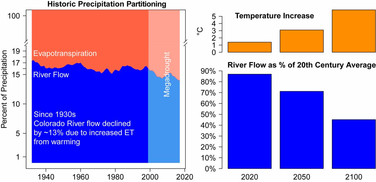
Discussions of droughts and their impacts often center on the lack of precipitation, just as assessments of hydrologic impacts under a changing climate most often focus on how average precipitation in a given locale is likely to change in the future. Within climate science, however, focus has begun to include the growing role warming temperatures are playing as a potent driver of greater aridity: hotter climate extremes; drier soil conditions; more severe drought; and the impacts of hydrologic stress on rivers, forests, agriculture, and other systems. This shift in the hydrologic paradigm is most clear in the American Southwest, where declining flows in the region’s two most important rivers, the Colorado (Fig. 1) and Rio Grande, have been attributed in part to increasing temperatures caused by human activities, most notably the burning of fossil fuels. Warmer summers are also likely to reduce flows in the Columbia River, as well as in rivers along the Sierra Nevada in California. Now, an important study documents how warming is also causing flow declines in the northern Rocky Mountains and in the largest river basin in the United States, the Missouri. This work further highlights the mechanisms behind the temperature-driven river flow declines and places more focus on how anthropogenic climate warming is progressively increasing the risk of hot drought and more arid conditions across an expanding swath of the United States.
Climate change is causing the Southwest to aridify. (Left) Since the 1930s, increasing temperatures have caused the percentage of precipitation going to evapotranspiration (ET) to increase at the expense of precipitation going to Colorado River flow, resulting in an unprecedented and still ongoing megadrought (shading) starting in 1999 (8). (Right) Higher temperatures have already reduced Colorado River flow by 13%, and projected additional warming, assuming continued high emissions of greenhouse gases, will increase ET while reducing river flow even more through the 21st century. Data on Left are 20-y running means from ref. 5, and data on Right are calculated from Representative Concentration Pathways (RCP) 8.5 multimodel Coupled Model Intercomparison Project–Phase 5 (CMIP5) ensemble temperature increases projected for the Upper Colorado River Basin combined with temperature sensitivity of −9.3%/°C estimated by ref. 5, assuming no change in precipitation.