It’s become so common, perhaps you’ve stopped noticing how often your local weather forecast is “above normal.” It’s noted during extreme heat in the summer, when mild temperatures persist through the winter, or when nights don’t cool down like they used to.
But on May 4, the hotter Earth will officially become the new normal.
That’s when the National Oceanic and Atmospheric Administration (NOAA) releases its once-a-decade update to “climate normals.” They are the 30-year averages for temperature and precipitation that local meteorologists rely on as the baseline for their forecasts. To be sure, some updates will be minuscule. But the fastest-warming places will see a real bump in their averages that could make some forecasts seem confusing and pose a challenge to meteorologists…
The current “normals” are from 1981-2010, based on data collected by thousands of monitoring stations around the country operated by the National Weather Service. The NOAA update will shift the time frame for those averages later, to the period from 1991 to 2020. The decade from 2011-2020 is one of the hottest on record in the U.S.
“It was a very substantial upward trend in temperature, especially along the West Coast, in the South and along the East Coast,” says Mike Palecki, with NOAA’s National Centers for Environmental Information.
There were exceptions; some places in the North Central part of the U.S. actually cooled a bit. But globally, the decade ending in 2020 was the hottest decade recorded since 1880…
Since the mid-20th century, Earth has warmed about 2 degrees Fahrenheit, and the pace of that warming has picked up in recent decades. Scientists warn that humans must keep global temperatures from rising more than about 3 degrees Fahrenheit in order to avoid the most catastrophic effects of climate change…
This year, to help businesses better prepare, NOAA for the first time will also put out 15-year averages using more recent temperature and precipitation data. It’s one of many ways the agency is helping people keep pace with a climate “normal” that just keeps changing.
The Cold Wave that occurred across the central United States in mid-February has preliminary damage losses in excess of $10 billion. Texas experienced the majority of these losses, with costly impacts occurring in more than a dozen additional states. This event is the most costly winter storm event on record for the U.S., surpassing losses associated with the Superstorm of 1993.
During March, the average contiguous U.S. temperature was 45.5°F, 4.0°F above the 20th-century average. This ranked in the warmest third of the 127-year period of record. The year-to-date (January-March) average contiguous U.S. temperature was 36.9°F, 1.8°F above average, also ranking in the warmest third of the record. The March precipitation total for the contiguous U.S. was 2.45 inches, 0.06 inch below average, and ranked in the middle third of the 127-year period of record. The year-to-date precipitation total was 6.55 inches, 0.41 inch above average, ranking in the middle third of the January-March record.
This monthly summary from NOAA National Centers for Environmental Information is part of the suite of climate services NOAA provides to government, business, academia and the public to support informed decision-making.
March
Temperature
Above-average temperatures were observed from the Northwest to the Great Lakes to the Gulf of Mexico and into the Northeast. Temperatures across North Dakota were fourth warmest on record. Below-average temperatures were present across parts of the West Coast during March.
The Alaska March temperature was 7.2°F, 3.6°F below the long-term average. This ranked in the coldest third of the 97-year period of record for the state and was the coldest March since 2017. On average, the coldest departures from average occurred across south-central Alaska while much of the North Slope was near average. Bering Sea ice extent was 81 percent of average for March, which contributed to above-average temperatures across the Aleutians.
Precipitation
Above-average precipitation was observed from the central U.S. to the Tennessee Valley and Gulf Coast in March. Nebraska precipitation ranked second wettest for the month. Below-average precipitation occurred across the Northwest, northern Plains, Northeast, as well as portions of the Southeast, Deep South and West. Montana and North Dakota ranked second driest on record for the month.
Precipitation across Alaska during March was much above average across western and northwestern Alaska as well as south of the Brooks Range. Juneau reported its snowiest March since 2007.
According to the March 30 U.S. Drought Monitor report, nearly 44 percent of the contiguous U.S. was in drought, down from 46.6 percent at the beginning of March. Drought conditions intensified and expanded across portions of the Northeast, Texas, northern Plains and California. Drought intensity and/or coverage lessened across parts of the central Rockies and central Plains as well as across Puerto Rico and was eliminated in Hawaii.
Year-to-date (January-March)
Temperature
Above-average temperatures were present across the Northern Tier and Northeast as well as portions of the West and Southeast. Despite the broad extent of warmth seen during March across the Lower 48, temperatures over the first three months of the year were near average across a wide portion of the U.S. This was in large part due to the cold weather experienced during February. Below-average temperatures occurred across portions of the South.
The Alaska January-March temperature was 6.3°F, 0.4°F above the long-term average, ranking in the middle third of the record for the state. Above-average temperatures occurred across Bristol Bay and the Aleutians during the first three months of 2021 with the remainder of the state experiencing near-average conditions.
Precipitation
Above-average precipitation stretched from the central Plains to the East Coast during January-March. Nebraska ranked second wettest on record. Dry conditions were present across much of the West, northern Plains, Great Lakes, Northeast and parts of the South and Southeast. North Dakota ranked driest on record for this three-month period.
For more detailed climate information, check out our comprehensive March 2021 U.S. Climate report scheduled for release on April 13, 2021.
Here’s the release from the NRCS Colorado (Brian Domonkos):
Several low-pressure systems moved across the state bringing heavy snow accumulations to the eastern slopes of the Colorado Rockies during March. Precipitation in March ranged from a high of 126 percent of average in the South Platte River Basin to as low of 86 percent of average in the combined Yampa-White-North Platte River Basins. NRCS Hydrologist Joel Atwood notes, “Generally storms in March improved snowpack across the state with the greatest gains in eastern river basins. Despite these storms, warmer temperature in the mountains have already begun melting the snowpack.” Snowpack as of April 8th ranges from a low of 71 percent of median in the combined San Miguel-Dolores-Animas-San Juan river basin to a high of 92 percent of median in the South Platte River Basin.
Statewide reservoir storage only increased by a percentage point over last month. Currently, the only river basin in the state holding above average reservoir storage is the combined Yampa-White river basins. On the low end, the combined San Miguel-Dolores-Animas-San Juan and the Arkansas river basins have 59 and 69 percent of average reservoir storage, respectively.
A drought that was well in place as the snowpack began to accumulate has had little relief with recent precipitation as all basins in the state continue to maintain below average water year-to-date precipitation. Before the water year, an exceptionally warm and dry summer and fall has resulted in extremely dry soils. NRCS Hydrologist Atwood continued to comment that “A combination of dry soils and below normal water year-to-date precipitation will likely moderate the runoff produced from snowmelt, producing lower volumes than would commonly be observed with a similar snowpack.”
The lowest streamflow forecasts in the state are rivers draining the Southern San Juan Mountains and the Gunnison River Basin. The average streamflow volume forecasts in these basins range from 36 to 77 percent of average. With recent storms, the Arkansas River Basin now has the best water supply outlook in the state, where streamflow volume forecasts range from 83 to 109 percent of average.
The outflow at the bottom of Navajo Dam in New Mexico. Photo: Brent Gardner-Smith/Aspen Journalism
From email from Reclamation (Susan Novak Behery):
In response to decreasing flows in the critical habitat reach, the Bureau of Reclamation has scheduled an increase in the release from Navajo Dam from 400 cubic feet per second (cfs) to 500 cfs on Friday, April 9th, starting at 4:00 AM. Releases are made for the authorized purposes of the Navajo Unit, and to attempt to maintain a target base flow through the endangered fish critical habitat reach of the San Juan River (Farmington to Lake Powell).
The San Juan River Basin Recovery Implementation Program recommends a target base flow of between 500 cfs and 1,000 cfs through the critical habitat area. The target base flow is calculated as the weekly average of gaged flows throughout the critical habitat area from Farmington to Lake Powell.
Click on a thumbnail graphic to view a gallery of drought data from the US Drought Monitor.
US Drought Monitor April 6, 2021.
West Drought Monitor April 6, 2021.
High Plains Drought Monitor April 6, 2021.
Colorado Drought Monitor April 6, 2021.
Click here to go to the US Drought Monitor website. Here’s an excerpt:
This Week’s Drought Summary
A cold front moving across the eastern half of the country last week brought showers and thunderstorms and left record-breaking cold temperatures in its wake. Meanwhile, dry conditions and warmer than normal temperatures continued in the West with many locations setting daily record high temperatures. The overall effect was a general deterioration of conditions across the Lower 48 as moisture deficits continued to build in the West and in locations in the eastern half of the country that missed out on the heaviest rainfall. Improvements were minimal and limited to parts of the Midwest and Southern Plains…
High temperatures in Nebraska and the Dakotas reached the upper 70s to mid-80s last week. With values of about 20 to 30 degrees above normal, many locations set daily records. These warm temperatures combined with low relative humidity and gusty winds to increase fire danger across the region. North and South Dakota declared fire emergencies due to ongoing drought conditions and increased wildfire activity. Severe (D2) and extreme (D3) drought expanded in both states as precipitation deficits continued to grow and increased evaporative demand dried out soils and stressed vegetation. USDA reports that, as of April 4, 92% of North Dakota’s topsoil and 68% of South Dakota’s topsoil was rated short to very short, indicating that soil moisture supplies are significantly less than what is required for normal crop growth development. In North Dakota, county Extension agents report that producers are starting to de-stock livestock herds by culling cows and grain farmers are very concerned about the lack of moisture. Photos show soil drift due to the dry conditions and high winds…
As the wet season begins to wind down in the West, widespread extreme (D3) to exceptional (D4) drought continues across much of the Southwest. Another week of warm, dry weather didn’t help. High temperatures ranged from 4 degrees above normal in the Northwest to 15 degrees above normal in the Southwest while little to no precipitation fell across much of the region. Where exceptions occurred, in the Pacific Northwest and the Northern Rockies, totals generally weren’t enough to overcome shortages. In eastern Washington, abnormal dryness (D0) and moderate drought (D1) expanded as precipitation deficits continued to increase, drying out soils. Conditions also deteriorated in Oregon. Most notably, D3 expanded and D4 was introduced in south central Oregon in response to record low water-year-to-date total precipitation, streamflow and soil moisture. It’s worth noting that since the U.S. Drought Monitor began in 2000, this is only the second time that D4 has occurred in the state (last occurrence in summer and fall of 2003). In California, the April 1 snow survey showed that snow water content in the Sierra Nevada Mountains was at 59% of average and the state, as a whole, received about 50% of its average precipitation for the water year. Two consecutive dry years have left reservoirs about half full. These precipitation deficits, combined with high temperatures, have reduced streamflow, dried out soils, and stressed vegetation. Changes to this week’s map include an expansion of D3 in northern California and western Nevada and an expansion of D2 (severe drought) and D3 in southern California. D1 expanded in northwest Wyoming and southeast Montana to reflect below normal precipitation over the water year and its effect on soil moisture and streamflow. Eastern Montana also saw deteriorating conditions with an expansion of D2 and D3. Here, the lack of precipitation over the last 2 to 3 months has dried out soils and stressed vegetation. USDA reports that, as of April 4, 76% of the state’s topsoil was rated short to very short indicating that soil moisture supplies are significantly less than what is required for normal crop growth development…
Showers and thunderstorms impacted the Lower Mississippi and Tennessee valleys last week, resulting in improvements to abnormally dry (D0) areas in Mississippi. Having missed out on the heaviest rainfall, drought and abnormal dryness generally expanded in the western part of the region. In Texas, degradations occurred throughout the state in response to rainfall deficits, increased evaporative demand and vegetation health. Most notable is an expansion of D3 (extreme) and D4 (exceptional) drought in the long-term drought area in the western part of the state. In Oklahoma, this week’s map shows broad expansions of D0 and D1 (moderate drought). Warm, dry weather combined with gusty winds increased evaporative demand, drying out soils and vegetation. The only improvements this week occurred in the Texas Panhandle and western Oklahoma. Despite the lack of rain last week, a reassessment of indicators shows that conditions have started to recover…
Looking Ahead
The National Weather Service Weather Prediction Center forecast for the next 5 days (April 8 through the 12) forecasts heavy rain and the potential for thunderstorms for the central U.S. As the storm system pushes eastward, chances increase for heavy rain and thunderstorms across the Upper Midwest, south-central, and southeastern U.S. In the Northwest, a storm moving in from the Pacific will bring colder than normal temperatures with snow likely falling in the Cascades and Northern Rockies and rain at lower elevations. In the Southwest and southern High Plains, warm, dry weather combined with gusty winds is expected to persist, leading to the potential continuation of dangerous fire weather conditions. Moving into next week, the Climate Prediction Center six- to 10-day outlook (valid April 12 through April 16) favors above normal temperatures across the West, Northeast and Southeast, with the largest probabilities centered over the Great Basin and New England. Below normal temperatures are most likely across the Great Plains, Mississippi Valley and Alaska. The greatest probabilities of above normal precipitation are across the Southern Plains, Southeast and Mid-Atlantic states.
US Drought Monitor one week change map ending April 6, 2021.
Adjacent areas that receive Colorado River water. Map credit: Los Alamos National Laboratory
Here’s the release from the Los Alamos National Laboratory (Charles Poling):
Climate change will drive more drought, heat waves, floods, and low river flows in seven western states
In the vast Colorado River basin, climate change is driving extreme, interconnected events among earth-system elements such as weather and water. These events are becoming both more frequent and more intense and are best studied together, rather than in isolation, according to new research.
“We found that concurrent extreme hydroclimate events, such as high temperatures and unseasonable rain that quickly melt mountain snowpack to cause downstream floods, are projected to increase and intensify within several critical regions of the Colorado River basin,” said Katrina Bennett, a hydrologist at Los Alamos National Laboratory and lead author of the paper in the journal Water. “Concurrent extreme events of more than one kind, rather than isolated events of a single type, will be the ones that actually harm people, society, and the economy.”
Another example of concurrent hydroclimate events might be low precipitation accompanied by high temperatures, which cause drought as an impact. Other factors such as low soil moisture or wildfire burn scars on steep slopes contribute to impacts.
“You never have just a big precipitation event that causes a big flood,” Bennett said. “It results from a combination of impacts, such as fire, topography, and whether it was a wet or dry summer. That’s the way we need to start thinking about these events.”
The Los Alamos study looked heat waves, drought, flooding, and low flows in climate scenarios taken from six earth-system models for the entire Colorado River basin. The basin spans portions of Wyoming, Colorado, New Mexico, Utah, Nevada, Arizona, and California.
Using indicators such as maximum temperature, maximum precipitation, dry days, maximum and minimum streamflow, maximum and minimum soil moisture, and maximum evapotranspiration, the team ran the models for a historical period (1970-1999) and a projected future period (2070-2099). They studied the difference between the two periods (future minus historical) for events at four time scales: daily, monthly, seasonal, and annual.
Overall, precipitation across the Colorado increased by 2.1 millimeters between the future and historical periods, with some models showing increases in precipitation and some showing decreases. Nonetheless, the team found that in all cases, precipitation changes still drove an increase in concurrent extreme events.
Brad Udall: Here’s the latest version of my 4-Panel plot thru Water Year (Oct-Sep) of 2019 of the #coriver big reservoirs, natural flows, precipitation, and temperature. Data goes back or 1906 (or 1935 for reservoirs.) This updates previous work with @GreatLakesPeck
Unsurprisingly, temperature increased across all six models and was an even stronger catalyst of events. Consistently across the entire basin, the study found an average temperature rise of 5.5 degrees Celsius between the future and historical periods.
In every scenario, the number and magnitude of each type of extreme event increased on average across the Colorado River Basin for the future period compared to the historical period. These numbers were given as a statistical expression of the change in frequency between the historical and future period, not as a count of discrete events.
Those increases have significant social, economic, and environmental implications for the entire region, which is a major economic engine for the United States. The study identified four critical watersheds in the Colorado basin — the Blue River basin, Uncompahgre, East Taylor, Salt/Verde watersheds — that are home to important water infrastructures, water resources, and hydrological research that would be particularly vulnerable to extreme events in the future.
More than 40 million people depend on the Colorado River basin for water, and it directly supports $1.4 trillion in agricultural and commercial activity — roughly 1/13 of the U.S. economy, according to 2014 figures.
In Utah, Colorado, Arizona, and New Mexico, flooding, drought, freezing events, wildfire, severe storms, and winter storms have cost approximately $40 billion between 1980–2020.
The Paper: “Concurrent Changes in Extreme Hydroclimate Events in the Colorado River Basin,” Katrina E. Bennett (corresponding author), Carl Talsma, and Riccardo Boero, in Water 2021, 13, 978, April 1, 2021. https://doi.org/10.3390/w13070978
The Funding: This work was funded by the Early Career Laboratory Directed Research and Development (LDRD) program at Los Alamos National Laboratory.
Ephemeral streams are streams that do not always flow. They are above the groundwater reservoir and appear after precipitation in the area. Via Socratic.org
For the second time in less than a year, state health officials plan to ask lawmakers to fast-track permitting authority over hundreds of miles of streams left unprotected after a 2020 Trump Administration rollback of federal Clean Water Act rules.
The Colorado Department of Public Health and Environment’s move comes just weeks after a federal court denied Colorado’s effort to prevent the new federal rules from taking effect.
The CDPHE is holding work group sessions and seeking public comment on a proposed bill that is likely to be introduced in the next two weeks, officials said. The CDPHE declined to comment for this article.
Last May Colorado Attorney General Phil Weiser sued the U.S. Environmental Protection Agency and won a temporary injunction against the new rules, which would have taken effect in June 2020. But a federal appeals court overturned that decision last month.
As a result, the rules are set to take effect in Colorado April 23. Though many expect the Biden Administration to alter the new rules, once again, state health officials say an interim rule is needed to ensure the state has the permitting authority and the funds needed to protect streams.
The CDPHE launched a similar effort last year, but a lack of support for that proposal caused the agency to withdraw it. Now agency officials say they will try again.
Major water interests, such as the nonpartisan Colorado Water Congress, are closely watching the latest legislative effort.
Colorado Water Congress Executive Director Doug Kemper said right now there is too much uncertainty around which streams and which activities will be overseen by federal and state agencies.
“It’s a big deal right now because you don’t really know what activity is covered and what is exempted,” said Kemper. His group has not taken a position on the CDPHE’s initiative, in part because a formal bill has yet to be introduced.
Environmentalists said it’s important that the state moves quickly to assume the permitting authority to protect streams and to allow millions of dollars in construction, dam and road projects to be properly reviewed and permitted.
Industry groups, however, believe new legislation isn’t required right now because the state has some discretion to act already and because the U.S. Army Corps of Engineers, which oversees much of the work on federally protected streams, also has some discretionary authority to review and issue permits.
“We’re concerned that the focus is solely on legislative options,” said John Kolanz, an attorney who represents the Colorado Stone, Sand and Gravel Association. He believes the state could make changes to its own rules, rather than enacting a new law.
“We don’t think it’s advisable to rush through legislation and a complicated rulemaking by the end of the year,” Kolanz said during a public work group meeting hosted by the CDPHE Monday.
Melinda Kassen, general counsel for the Theodore Roosevelt Conservation Partnership who tracks water quality regulation, disagreed, saying the CDPHE must be given new legal authority quickly in order to adequately monitor and fund stream protection work over the next one to two years.
“The biggest part of this legislation is getting some fees so that the [Colorado Water Quality Control] division can do its job and go out and see what’s happening on the ground,” Kassen said Monday.
At issue is what’s known as the Waters of the U.S. (WOTUS) rule. The rule was designed to classify which streams are subject to federal rules and which activities must obtain permits from the Army Corps to ensure those streams are protected even when they are disturbed by home and road building, construction of new storm water systems, and other activities.
But WOTUS has been contested in courts for years over murky definitions about which waterways fall under its jurisdiction, which wetlands must be regulated, what kinds of dredge-and-fill work in waterways should be permitted, what authority the CWA has over activities on farms and Western irrigation ditches, and what is allowable for industries and wastewater treatment plants to discharge into streams.
It has also been difficult to administer because the U.S. is home to such a wide variety of waterways.
In the East and Midwest massive rivers are filled with barge and shipping traffic and are clearly “navigable.” That was the term early courts used to determine how water would be regulated. If a stream was considered navigable, it was subject to federal law.
But Colorado and other Western states rely on shallow streams that don’t carry traditional commercial traffic. The U.S. Geological Survey estimates 44 percent of Colorado’s streams are intermittent, meaning they are sometimes dry, and 24 percent are ephemeral, meaning they can be dry for months or years and appear only after extraordinary rain or snow. Just 32 percent of Colorado streams are classified as being perennial, meaning they flow year round.
Under the new federal rule only perennial and intermittent streams, or those deemed navigable, are regulated, meaning that thousands of miles of streams in Colorado and other Western states are no longer protected under the law.
If the CDPHE’s new legislative effort succeeds, it would give state health officials the authority to issue so-called dredge-and-fill permits on stream segments no longer protected by the federal law.
Jerd Smith is editor of Fresh Water News. She can be reached at 720-398-6474, via email at jerd@wateredco.org or @jerd_smith.
Another small but important piece of the giant puzzle that Holy Cross Energy has set out to solve was revealed Tuesday.
The electrical cooperative serving members in the Vail-Aspen-Rifle area has agreed to purchase electricity from a solar and battery storage project being built by Ameresco Inc. Near Glenwood Springs, on the Spring Valley Campus of Colorado Mountain College, the company will install solar panels capable of generating a maximum of 4.5 megawatts of electricity.
Adjacent to the solar panels it will operate battery storage with a capacity of 5 megawatts (or 15 megawatt hours). Batteries will be charged with electricity generated by the solar panels.
The batteries can be tapped to supply electricity during times of peak demand on a daily basis. In the Vail-Aspen area, peak demand typically occurs in evening hours, with the strongest demand during winter months.
The lithium-iron-phosphate batteries can also augment Holy Cross’s electrical generation during times of disruption, such as caused by wildfires or storms.
“That battery and local generation is an important part of the infrastructure that is real important to creating a resilient energy system for the future,” said Steve Buening, the vice president for power supply and programs at Holy Cross.
The battery storage will be able to have 5 megawatts of power vs. 15 megawatt-hour of capacity. Beuning compares the 5 megawatts to what happens when you press on the gas pedal of an internal-combustion car, while the mega-watt hour is how much the gas tank can hold.
With 45,000 members, Holy Cross is among the larger of Colorado’s 22 electrical cooperatives. As of 2018 it was responsible for 2.2% of electrical sales in the state.
This is from Big Pivots, an e-magazine. To get a free subscription, sign up at http://bigpivots.com
Holy Cross has been assembling disparate pieces of infrastructure, some in and among the communities it services, others hundreds of miles away, as it pursues a goal of completely decarbonizing its electrical supply by 2030.
In addition to the new solar-plus-storage complex near Glenwood Springs, Holy Cross plans a 5-megawatt solar farm on McCain Flats, near the Aspen/Pitkin County Airport. Construction is scheduled to begin this spring.
Complementing this local generation will be electricity generated for Holy Cross at the Arriba wind farm, to be constructed during the next year along Interstate 70 near the eponymously named town 120 miles southeast of Denver. The wind farm will have 100 megawatts of capacity, enough to supply roughly a third of demand by Holy Cross members.
In storage, Holy Cross has something of the same approach, a mixture of local and smaller and elsewhere and larger.
Directors of Holy Cross in 2020 adopted a plan that lays out potential strategies, including pumped-storage hydro. Water in pumped-storage projects is released to generate electricity to meet peak demands, then pumped uphill again when electricity is more abundant and hence cheaper.
It’s not new technology. Colorado has two such projects, the larger and older being near Georgetown. There, the Cabin Creek project uses a 1,200 feet vertical drop between two reservoirs to generate a maximum of 324 megawatts. The system went on-line in 1967 but has been upgraded since then.
Bryan Hannegan, the chief executive of Holy Cross, has spoken about the value of small pumped-storage hydro projects in the Aspen-Vail area, perhaps combined with larger capacity pumped-storage projects elsewhere.
Why the battery storage now for Holy Cross instead of waiting for prices to tumble further. Prices of battery storage have dropped about 80% in the last decade and are projected to decline even more, from $137 per kilowatt-hour to as low as $100 by 2023, according to Bloomberg New Energy Finance.
Holy Cross decided that the prices were already good enough.
“One thing that may be holding back investment in utility-scale energy storage is concerns about being an early adopter at higher prices than in the future if battery prices continue their downward trend,” says Buening.
That being noted, the savings are good enough already to yield lower costs of electricity for Holy Cross members.
“We were ready to go ahead,” he says.
Xcel is also planning 275 megawatts of battery storage as it closes two coal-fired power units at Pueblo in the next several years. In a recent filing with the Colorado Public Utilities Commission, the utility plans even more in the years beyond 2024. It’s Colorado’s largest utility with 52.5% of Colorado’s electrical sales for 2018.
Photo at top is rendering of the solar-plus-storage project at the Spring Valley Campus near Glenwood Springs.
City of Steamboat Springs officials know the municipality’s primary fresh water supply is increasingly at risk from potential wildfire danger in the Fish Creek watershed, so work will continue this summer to boost water supply redundancy.
The city along with Mount Werner Water District are proceeding with construction of enhanced and expanded “infiltration galleries,” or shallow wells that are filled by ground water near the Yampa River, to increase the volume of secondary water supply intake. Water collected through the Yampa well field, which is located near where Walton Creek meets the Yampa River, is piped to the nearby Yampa Water Treatment Plant
Frank Alfone, water district general manager, said the district’s work should be complete by Dec. 1 for a third shallow well and new raw water transmission line located about a quarter mile south of the district’s two existing wells. The additional well will push intake capacity for 2022 from 1.8 million gallons per day to 2.8 million.
The Yampa Water Treatment Plant, built in 1972, has about half the capacity of the primary Fish Creek Filtration Plant. The Yampa plant was updated in 2018 to be able to process more gallons per day and is used primarily to process water for the outdoor watering season from June through September, Alfone said.
Kelly Romero-Heaney, city water resources manager, said the city will open up bids in 2022 for construction of four additional Yampa River shallow wells to increase the overall intake capacity in the location to 3.5 million gallons per day, which would be available by 2023.
The secondary water intake improvements are part of the city’s updated Water Supply Master Plan, completed in 2019, and a key component of the overall supply plan is the updated Water Conservation Plan approved in May, Romero-Heaney said. The goal of the 10-year Water Conservation Plan is to reduce the amount of water used per household by 10%…
[Romero-Heaney] said the city accomplished six key water conservation measures in 2020. Steamboat Springs City Council and the district adopted regulations that permanently limit outdoor watering to between 6 p.m. and 10 a.m. three days per week based on the last digit of a street address. The city replaced 619 feet of aging and possibly leaking water lines, fixed five water main breaks and replaced irrigated sod in front of City Hall with a low water use demonstration garden.
The city updated the water distribution infrastructure master plan to prioritize water line replacements to mitigate leaks and water loss…
Screenshot from the linked Steamboat Pilot & Today article April 7, 2021.
The updated conservation plan, posted on the city’s Water Conservation webpage, notes the city is actively engaged in meeting a variety of challenges to ensure a reliable water supply. Those challenges include drought, wildfire, need for more water treatment capacity, uncertainty of Colorado River Compact call, aging infrastructure, low flows in Fish Creek, growth in the west Steamboat Springs area and the uncertainty of climate change that has increased the statewide annual average temperatures by 2.5 degrees through the past 50 years…
The plan looks to preserve the health of Fish Creek and the Yampa River and protect drinking water supplies while reducing the use of chemicals and the energy intensive carbon footprint of treating fresh water and waste water. The plan also factors in the water requirements of the estimated 400,000 to 500,000 visitors to the city each year.
Steamboat’s primary source of treated water comes from snowmelt from the 22-square-mile Fish Creek watershed. Those supplies are stored in Fish Creek and Long Lake reservoirs and treated at the Fish Creek Filtration Plant.
Questions about the water conservation plan can be emailed to kromeroheaney@steamboatsprings.net.
Students in Sam Ng’s Field Observation of Severe Weather class hit the road every spring to observe storm structures, like this mesocyclone in Imperial, Nebraska. Photo by Sam Ng via Metropolitan State University of Denver
FromThe Associated Press (Matthew Brown) via The Denver Post:
Rainstorms grew more erratic and droughts much longer across most of the U.S. West over the past half-century as climate change warmed the planet, according to a sweeping government study released Tuesday that concludes the situation is worsening.
The most dramatic changes were recorded in the desert Southwest, where the average dry period between rainstorms grew from about 30 days in the 1970s to 45 days between storms now, said Joel Biederman, a research hydrologist with the U.S. Department of Agriculture Southwest Watershed Research Center in Tucson.
The consequences of the intense dry periods that pummeled areas of the West in recent years were severe — more intense and dangerous wildfires, parched croplands and not enough vegetation to support livestock and wildlife. And the problem appears to be accelerating, with rainstorms becoming more unpredictable and more areas showing longer intervals between storms since the turn of the century compared to prior decades, the study concludes.
High Plains Drought Monitor March 30, 2021.
West Drought Monitor March 30, 2021.
The study comes with almost two-thirds of the contiguous U.S. beset by abnormally dry conditions. Warm temperatures forecast for the next several months could make it the worst spring drought in almost a decade, affecting roughly 74 million people across the U.S., the National Oceanic and Atmospheric Administration said…
Climate scientists are calling what’s happening in the West a continuation of a “megadrought” that started in 1999.
While previous research documented a decline in total rainfall for much of the West, the work by Biederman and colleagues put more focus on when that rain occurs. That has significant implications for how much water is available for agriculture and plants such as grasses that have shallow roots and need a steadier supply of moisture than large trees.
“Once the growing season starts, the total amount of rainfall is important. But if it comes in just a few large storms, with really long dry periods in between, that can have really detrimental consequences,” Biederman said in an interview.
The total amount of rain in a year doesn’t matter to plants — especially if rains come mostly in heavy bursts with large run-off — but consistent moisture is what keeps them alive, said UCLA meteorologist Daniel Swain, who writes a weather blog about the West and was not part of the study.
The new findings were published in the journal Geophysical Research Letters. Researchers led by University of Arizona climate scientist Fangyue Zhang compiled daily readings going back to 1976 from 337 weather stations across the western U.S. and analyzed rainfall and drought data to identify the changing patterns…
The rainfall study is in line with data that shows climate change already is affecting the planet…
“Climate models project that the American Southwest is very likely to experience more frequent and more severe droughts,” said William Anderegg, a University of Utah biologist and climate scientist. “This study and other recent work demonstrates that this dry down has already begun.”
The weather station data that was used in the study represents “the gold standard’ for an accurate understanding of changes being driven by climate change, said Christopher Field, an earth systems scientist and director of the Stanford Woods Institute for the Environment.
Unrelenting drought and years of rising temperatures due to climate change are pushing the long-overallocated Colorado River into new territory, setting the stage for the largest mandatory water cutbacks to date.
Lake Mead, the biggest reservoir on the river, has declined dramatically over the past two decades and now stands at just 40% of its full capacity. This summer, it’s projected to fall to the lowest levels since it was filled in the 1930s following the construction of Hoover Dam.
The reservoir near Las Vegas is approaching a threshold that is expected to trigger a first-ever shortage declaration by the federal government for next year, leading to substantial cuts in water deliveries to Arizona, Nevada and Mexico.
Arizona is in line for the biggest reductions under a 2019 agreement that aims to reduce the risks of Lake Mead falling to critical lows.
The river has been slipping closer to a shortage for years, and the drought has deepened over the past year, shrinking the flow of streams that feed the river in its headwaters in the Rocky Mountains. The soils across the watershed remain parched and will soak up some of the melting snow this spring and summer. The amount of water that flows into Lake Powell at the Utah-Arizona state line over the next four months is projected to be only about 45% of the long-term average and among the lowest totals in years.
April 1, 2021 streamflow forecast Colorado Basin River Forecast Center.
Legend for streamflow forecast.
With the reservoirs continuing to drop, the expected cuts next year will reduce the Central Arizona Project’s water supply by nearly a third…
Managers of Arizona’s water agencies say they have detailed plans in place to deal with the reductions in water supplies over the next five years, even if the drought continues to worsen. These initial steps to cope with shortages are playing out while the seven states that depend on the river prepare for difficult talks on post-2026 rules, negotiating a plan for adapting to a river that’s yielding less as the watershed grows progressively warmer with climate change…
Officials who manage Arizona’s 336-mile Central Arizona Project Canal, which runs from Lake Havasu to Tucson, have known since plans were first drawn up for the system that they hold the lowest priority and could face cuts in a shortage…
Representatives of the seven states in the Colorado River Basin signed the set of agreements known as the Drought Contingency Plan nearly three years ago in a ceremony at Hoover Dam. Under one of the agreements, Arizona and Nevada agreed to take the first cuts to help prop up the level of Lake Mead, while California would participate at lower shortage levels if the reservoir continues to fall.
Under a separate deal, Mexico agreed to help by leaving some of its water in Lake Mead.
The deals lay out shortage tiers based on Mead’s levels. The federal government’s latest projections show the lake level will sit below the threshold elevation of 1,075 feet at the beginning ofnext year, triggering what’s called a Tier One shortage.
For Arizona, that means a cut of 512,000 acre-feet or about a third of the CAP’s supply…
The Colorado River’s flow has shrunk during one of the driest 22-year periods in centuries. Scientists say the West is experiencing a megadrought and one that’s worsened by humanity’s heating of the planet.
The drought over the past year has hit especially hard in the Colorado River watershed. Last spring and summer, months of extreme heat combined with the lack of monsoon rains baked the soils dry and shrank the amount of runoff, sapping the river and its tributaries.
Westwide SNOTEL basin-filled map April 6, 2021 via the NRCS.
This winter, the storms that rolled across the Rockies brought some snow, but not nearly enough to brighten the picture. The snowpack in the Upper Colorado River Basin now stands at 75% of the median for this time of year…
The upshot, as climate researcher Jeff Lukas puts it, is that “the exceptionally low soil moisture will turn a blah snowpack into a terrible runoff year.”
The effects will ripple downstream to Lake Powell and Lake Mead, which hold supplies for cities, farming districts and tribes across the Southwest.
The country’s two largest reservoirs are both headed for record lows. The last time Lake Mead reached a record low level was in 2016. The latest projections from the federal Bureau of Reclamation show Mead could fall below that mark as soon as July. Lake Powell is now just 36% full, and estimates show it could decline to a record low around March 2022.
Pushback against a “meatless day” proclaimed by Colorado Gov. Jared Polis last month was predictably vigorous. It was part of the “war on rural Colorado,” said a state senator who runs a cattle-feeding operation. Twenty-six of Colorado’s 64 counties adopted “meat-in” proclamations. Governors from the adjoining states of Wyoming and Nebraska even gleefully designated an “eat-meat” day.
Afterward, Polis’s press aides pointed to the hundreds of do-good proclamations the governor issues each year, and the governor quickly declared his beef brisket the rival of any in Colorado.
But this proclamation differed from those affirming truck drivers, bat awareness and breakfast burritos. It called for broad change. Using the language of a “MeatOut” Day proclamation written by an animal rights group, his statement cited the benefits of a plant-based diet in reducing our carbon footprint, preserving ecosystems and preventing animal cruelty. It also noted the growing alternatives to meat, dairy and eggs.
In the 1880s, when my great-grandparents homesteaded in eastern Colorado, they grazed cattle on the short-grass prairie. Ranchers still do. Once off the range, though, our beef production is best understood as an industrial process. The foundation is grain.
In his book How to Avoid a Climate Disaster, Bill Gates explains the modern pyramid of protein: A chicken eats two calories’ worth of grain to give us one calorie of poultry. For cattle, it’s six calories of feed to produce one calorie of beef. I’ve stood in rows of corn tassels 12 feet high at maturity, the growth boosted by luxuriant applications of fertilizer. I’ve pinched my nose while driving past feedlots large enough for 80,000 or more head. I’ve heard the bellow of cows minutes away from the knife at slaughterhouses.
Denver no longer has slaughterhouses but still prides itself on its livestock heritage. The annual Western Stock Show puts cowboy hats in high-end restaurants and strip joints alike. Cattle represent 50% of Colorado’s $7 billion agriculture economy, and livestock altogether 70%. After Polis’s proclamation, livestock producers debated boycotting Denver’s Stock Show for other venues — perhaps Oklahoma.
Even a legislator from one of metro Denver’s poorer neighborhoods objected to Polis’s proclamation, pointing out that nutritious vegetarian options aren’t available to many of her constituents.
But it’s not just low-income areas that lack meal choices. Fast-food franchises in big cities and small towns all cater to the lowest-common denominator, their high-volume enterprises predicated on cheap meat, especially beef. The consequences are that we now have bulbous bellies and too many heart attacks. We struggle to live with restraint.
The meaty issue here is not about meat vs. no-meat. Rather, it’s about scale and processes. What have we sacrificed in pursuit of volume?
Credit the ranchers who graze cattle holistically in an attempt to replicate the once-vast herds of bison. But also note that grass-fed beef needs buyers. Most holistically raised cows get further fattened on grain. That’s where the market is.
There’s also the looming issue of cows contributing to climate change, as highly polluting methane comes out of both ends of cattle. Gates, always the technologist, insists that innovation can reduce the carbon output of agriculture by reducing our yen for real beef. He put his money where my mouth is by investing in a vegetarian product called the Impossible Burger. Last week I had one. It fooled me. I thought it was beef.
Meanwhile, the urban-rural divide remains starkly real and evident in voting and development patterns. While cities struggle to contain their growth, many small towns struggle to hang on. Ironically, the economies of most of these at-risk rural towns are premised on industrial-scale agriculture.
Rural Colorado never has liked Polis, a savvy businessman from the exurbs of Boulder who favors market solutions. He had barely warmed his gubernatorial seat when handmade signs began showing up on rural country roads asking “Why does Polis hate…” You fill in the blank.
This meatless proclamation was tone-deaf. It could have narrowly affirmed meatless alternatives rather than decried meat. Denial and anger will not prevail, though. I’m reminded of when coal producers, 10 and 15 years ago, were fighting the future of renewables instead of figuring out their place in the world to come.
Though most of us may continue to eat beef, some of us have already begun to shift away. Polis was perhaps the unwitting messenger of that truth — that cows in the West are no longer sacred.
Allen Best contributes to Writers on the Range, http://writersontherange.org, an independent nonprofit dedicated to spurring lively conversation about the West. He writes about energy and water in http://BigPivots.com, his e-magazine.
Rio Grande and Pecos River basins. Map credit: By Kmusser – Own work, Elevation data from SRTM, drainage basin from GTOPO [1], U.S. stream from the National Atlas [2], all other features from Vector Map., CC BY-SA 3.0, https://commons.wikimedia.org/w/index.php?curid=11218868
Here’s the release from the University of Colorado (Kelsey Simpkins):
More snow is melting during winter across the West, a concerning trend that could impact everything from ski conditions to fire danger and agriculture, according to a new CU Boulder analysis of 40 years of data.
Researchers found that since the late 1970s, winter’s boundary with spring has been slowly disappearing, with one-third of 1,065 snow measurement stations from the Mexican border to the Alaskan Arctic recording increasing winter snowmelt. While stations with significant melt increases have recorded them mostly in November and March, the researchers found that melt is increasing in all cold season months—from October to March.
Their new findings, published [April 5, 2021] in Nature Climate Change, have important implications for water resource planning and may indicate fewer pristine powder days and crustier snow for skiers.
“Particularly in cold mountain environments, snow accumulates over the winter—it grows and grows—and gets to a point where it reaches a maximum depth, before melt starts in the spring,” said Keith Musselman, lead author on the study and research associate at the Institute of Arctic and Alpine Research (INSTAAR) at CU Boulder.
Combined photos of the Senator Beck basin in the Colorado San Juan mountains during increasingly warmer months. (Credit: Jeffrey Deems/CIRES and Matthew Kennedy/CU Boulder Extreme Ice Survey)
But the new research found that melt before April 1 has increased at almost half of more than 600 stations in western North America, by an average of 3.5% per decade.
“Historically, water managers use the date of April 1 to distinguish winter and spring, but this distinction is becoming increasingly blurred as melt increases during the winter,” said Noah Molotch, co-author on the study, associate professor of geography and fellow at INSTAAR.
Snow is the primary source of water and streamflow in western North America and provides water to 1 billion people globally. In the West, snowy mountains act like water towers, reserving water up high until it melts, making it available to lower elevations that need it during the summer, like a natural drip irrigation system.
“That slow trickle of meltwater that reliably occurs over the dry season is something that we have built our entire water infrastructure on in the West,” said Musselman. “We rely very heavily on that water that comes down our rivers and streams in the warm season of July and August.”
More winter snowmelt is effectively shifting the timing of water entering the system, turning that natural drip irrigation system on more frequently in the winter, shifting it away from the summer, he said.
This is a big concern for water resource management and drought prediction in the West, which depends heavily on late winter snowpack levels in March and April. This shift in water delivery timing could also affect wildfire seasons and agricultural irrigation needs.
Wetter soils in the winter also have ecological implications. One, the wet soils have no more capacity to soak up additional water during spring melt or rainstorms, which can increase flash flooding. Wetter winter soils also keep microbes awake and unfrozen during a time they might otherwise lay dormant. This affects the timing of nutrient availability, water quality and can increase carbon dioxide emissions.
SNOTEL Site via the Natural Resources Conservation Service
An underutilized data source
Across the western U.S., hundreds of thin, fluid-filled metal pillows are carefully tucked away on the ground and out of sight from outdoor enthusiasts. These sensors are part of an extensive network of long-running manual and automated snow observation stations, which you may have even used data from when looking up how much snow is on your favorite snowshoeing or Nordic skiing trail.
This new study is the first to compile data from all 1,065 automated stations in western North America, providing valuable statistical insight into how mountain snow is changing.
And by using automated, continuously recording snowpack stations instead of manual, monthly observations, the new research shows that winter melt trends are very widespread—at three-times the number of stations with snowpack declines, according to Musselman.
Snowpack is typically measured by calculating how much water will be produced when it melts, known as snow-water equivalent (SWE), which is affected by how much snow falls from the sky in a given season. But because winter snowpack melt is influenced more by temperature than by precipitation, it is a better indicator of climate warming over time.
“These automated stations can be really helpful to understand potential climate change impacts on our resources,” said Musselman. “Their observations are consistent with what our climate models are suggesting will continue to happen.”
Other authors on this publication include Nans Addor at the University of Exeter and Julie Vano at the Aspen Global Change Institute.
Storm clouds gather as cows graze at the USDA-ARS Central Plains Experimental Range near Nunn, Colo. Photo by David Augustine/USDA-ARS via the Fence Post
Here’s the release from the U.S. Department of Agriculture (Kim Kaplan):
Dry periods between rainstorms have become longer and annual rainfall has become more erratic across most of the western United States during the past 50 years, according to a study published by the U.S. Department of Agriculture’s Agricultural Research Service and the University of Arizona.
Against the backdrop of steadily warming temperatures and decreasing total yearly rainfall, rain has been falling in fewer and sometimes larger storms, with longer dry intervals between. Total yearly rainfall has decreased by an average of four inches over the last half century, while the longest dry period in each year increased from 20 to 32 days across the West, explained co-senior author Joel Biederman, a research hydrologist with the ARS Southwest Watershed Research Center in Tucson, Arizona.
“The greatest changes in drought length have taken place in the desert Southwest. The average dry period between storms in the 1970s was about 30 days; now that has grown to 45 days,” Biederman said.
Extreme droughts are also occurring more often in the majority of the West according to historical weather data as there has been an increase in the year-to-year variation of both total rainfall amounts and the duration of dry periods.
Biederman emphasized the growing fluctuations in drought and rain patterns as the most significant change.
“Consistency of rainfall, or the lack of it, is often more important than the total amount of rain when it comes to forage continuing to grow for livestock and wildlife, for dryland farmers to produce crops, and for the mitigation of wildfire risks,” Biederman said.
The rate of increasing variability of rainfall within each year and between years also appears to be accelerating, with greater portions of the West showing longer drought intervals since 2000 compared to previous years.
Notable exceptions to these drought patterns were seen in Washington, Oregon and Idaho and the Northern Plains region of Montana, Wyoming, and the most western parts of North and South Dakota. In these regions, the researchers found some increases in total annual rainfall and decreases in drought intervals. Together, these changes support what models have predicted as a consequence of climate change: a northward shift in the mid-latitude jet stream, which brings moisture from the Pacific Ocean to the western United States, according to Biederman.
A critical aspect of this study is the use of actual rainfall data from 337 weather stations spread across the western United States. Biederman contrasted this with the more common use of “gridded” data, which relies on interpolations between reporting stations and tends to smooth out some of the variability revealed by this work.
“Fangyue Zhang, lead author of the manuscript and a post-doctoral researcher on our team, did the hard, painstaking work of compiling and analyzing data from more than 300 weather stations with complete daily records to reveal these changing drought and rainfall patterns,” Biederman said.
“We were surprised to find widespread changes in precipitation have already occurred across large regions of the West. For regions such as the desert Southwest, where changes clearly indicate a trend towards longer, more erratic droughts, research is urgently needed to help mitigate detrimental impacts on ecosystem carbon uptake, forage availability, wildfire activity, and water availability for people,” said co-senior author William K. Smith, assistant professor, University of Arizona.
This research was published in Geophysical Research Letters.
FromThe Tri-State Livestock News (Ruth Wiechmann) via The Fence Post:
The United States Drought Monitor continues to indicate a critical lack of moisture for much of the Great Plains. March snowstorms brought a bit of relief to some areas but forecasted warmer and drier than normal conditions for the foreseeable future stand poised to suck the soil dry again.
Adnan Akyuz, North Dakota state climatologist at North Dakota State University, says that it is unusual for North Dakota to be so dry this time of year.
“This extreme level of drought is unusual,” he said. “Our Drought Severity and Coverage Index is sitting at 331 right now, the highest on record since 2000. This does make it look like we are in the worst drought, but we are just looking at one facet of the data in the DSCI. We also need to consider the accumulated impact of drought over time. Based on the accumulated DSCI the current conditions follow the drought of 2002-05, 2017-18, 2008-09, 2012-13, and 2006-07. However, we have to keep in mind that the growing season has just started and the impact will accumulate.”
[…]
Akyuz is concerned for the long term, with 47 percent of the state experiencing Extreme Drought (D3) and 100 percent of North Dakota in Moderate Drought (D1) or higher according to the U.S. Drought Monitor. He said that the lack of the usual snow cover through the past winter is significant…
It’s a perfect storm, and it’s turning into dust storms across the area. Akyuz said that extension agents across North Dakota sent him photos following recent wind storms clocking gusts up to 79 miles per hour that are reminiscent of the photos of dirt drifts from the Dust Bowl years of the 1930s.
“I don’t think we’ve ever had a drought that compares with the ‘Dirty Thirties,’” he said. “There was no significant precipitation to mitigate that drought for a decade. The 1930 drought was finally over in 1941 with precipitation that year adding up to the wettest growing season on record for North Dakota. We’re not there yet but I don’t see a significant change in weather patterns coming soon.”
Akyuz said that in spite of their severity, current conditions do not match the intensity of Exceptional Drought (D4) conditions seen in 2006 and 2017, nor the extended periods of drought seen in the 1950s and in the six-year drought spanning 1987-1992…
A mid-March snowstorm brought some relief to areas of southern South Dakota, much of Wyoming and Nebraska, but Tony Bergantino, climatologist at the University of Wyoming, is concerned that the benefit could be short lived…
While Wyoming tends to be on the dry side, and Bergantino says that drought is certainly not unprecedented, he sees current conditions and predictions for the coming months pointing to below normal precipitation and above normal temperatures.
“I’m hoping for more moisture,” he said, “But it looks like we could see something similar to the 2012 drought or the dry years in the early 2000s. One thing that helped us in 2012 early on was that we were coming off a year of really good snowpack which helped fill the reservoirs. So we were in better shape going into 2012. 2020 was not good at all so we have a double whammy going into 2021.”
[…]
Laura Edwards, South Dakota State University’s Extension state climatologist in Aberdeen, said that parts of the northern tier of South Dakota counties have seen no measurable precipitation in March, when moisture amounts normally start to increase in the state.
Construction work to repair the Goose Pasture Tarn Dam is set to begin this month.
While the dam is located in Blue River, the rehabilitation project is being led by Breckenridge, which owns and operates the dam. Water from the Goose Pasture Tarn goes to the Gary Roberts Water Treatment Plant, which serves the residents of Breckenridge.
According to a press release from the town, rehabilitation of the dam includes the replacement of two existing spillways with a single, larger spillway that is intended to improve the safety of the dam. Officials expect the project to be completed in the fall of 2023. The dam repair project is expected to cost a total of $20 million, which is being paid for by Breckenridge, Colorado and the Federal Emergency Management Agency.
Moving forward with the project is a sigh of relief for Breckenridge residents because the dam, which was constructed in 1965, was classified as a “high hazard” in the U.S. Army Corps of Engineers’ 2018 National Inventory of Dams. The press release noted that the dam wasn’t classified as a high hazard because of its condition. Instead, the designation was based on the estimated consequences if the dam were to fail. However, safety issues during high flows were identified in 2016, and as a result, reservoir-storage restrictions were put in place that reduced flows…
Phelps said the Goose Pasture Tarn’s water level will be lowered for about a month near the end of July. The water will be lowered for a longer period of time next summer. During the project, recreational use of the tarn is prohibited and the lowering of water levels may impact nearby residential wells. The release said that the town has installed monitoring wells to track fluctuations in groundwater levels near the reservoir and will “enact additional measures” to reduce impacts.
Phelps explained that construction work is planned to happen within three time frames: April 2021 through September 2021, April 2022 through September 2022, and May 2023 through the fall of 2023. Work could be done as early as the end of August 2023. Phelps noted that the heavy construction work will be completed in 2022, and a lot of the work that will be done in the final phase of the project will be to revegetate the area around the dam.
The blizzard that dumped snow along the Front Range in March helped Colorado nearly reach its average snowpack for the winter, federal data shows.
But last year’s historically dry weather means that streams are likely to run lower than normal, potentially restricting the amount of water some consumers can use, experts said Thursday…
State snowpack levels were at 93 percent of the average for the state as of April 1, according to the Natural Resources Conservation Service…
That figure was higher in 2020 when the snowpack was above average for the same date. Still, a dry spring and hot summer made it one of the driest years on record and created drought conditions that sparked some of the worst fires in state history.
The outlook for snowfall at the beginning of the year looked dismal. But a string of strong snowstorms, including March’s blizzard, pushed state numbers back on track. Areas east of the Continental Divide had above average snowpack, but the Colorado River Basin on the west was below average.
Scientists can use the snowpack to predict the amount of water that will run through streams and river channels, said Ben Livneh, an assistant professor in civil engineering at CU Boulder. Although the snow will help with the drought, those streams are still expected to run below average, he said.
A major factor of this is the soil, he said, which has remained dry since last year. As the snow melts down the mountains, the water will first have to replenish the soil before it continues toward the reservoirs…
Forecasts don’t predict substantial precipitation before most of the snow melts this summer, Livneh said. But there is still the potential for recovery.
“The next couple of weeks is really critical,” he said. “If we can build more substantial snowpack, a longer lasting snowpack, that would actually help us a lot.”
Westwide SNOTEL basin-filled map April 4, 2021 via the NRCS.
Gross Reservoir — The Gross Reservoir Expansion Project will raise the height of the existing dam by 131 feet, which will allow the capacity of the reservoir, pictured, to increase by 77,000 acre-feet. The additional water storage will help prevent future shortfalls during droughts and helps offset an imbalance in Denver Water’s collection system. With this project, Denver Water will provide water to current and future customers while providing environmental benefits to Colorado’s rivers and streams. Photo credit: Denver Water
A federal judge has thrown out a legal action from multiple environmental organizations seeking to halt the expansion of a key Denver Water storage facility, citing no legal authority to address the challenge.
“This decision is an important step,” said Todd Hartman, a spokesperson for Denver Water. “We will continue working earnestly through Boulder’s land-use process and look forward to beginning work on a project critical to water security for 1½ million people and to our many partners on the West Slope and Front Range.”
The expansion of Gross Reservoir in Boulder County is intended to provide additional water storage and safeguard against future shortfalls during droughts. The utility currently serves customers in Denver, Jefferson, Arapahoe, Douglas and Adams counties. In July 2020, the Federal Energy Regulatory Commission gave its approval for the design and construction of the reservoir’s expansion. The project would add 77,000 acre-feet of water storage and 131 feet to the dam’s height for the utility’s “North System” of water delivery.
FERC’s approval was necessary because Denver Water has a hydropower license through the agency, and it provided the utility with a two-year window to start construction.
A coalition of environmental groups filed a petition in U.S. District Court for Colorado against the U.S. Army Corps of Engineers and the U.S. Fish and Wildlife Service, seeking to rescind those agencies’ previous authorizations for the project. They argued the agencies inadequately considered the environmental impact of expansion…
…Denver Water pointed out that under federal law, appellate courts, not district-level trial courts, are responsible for hearing challenges to FERC approvals. By challenging the environmental review process that led to the project’s go-ahead, the government argued, the environmental organizations raised issues “inescapably intertwined with FERC’s licensing process.”
On Wednesday, U.S. District Court Judge Christine M. Arguello agreed that the groups’ challenge was indeed wrapped up in the FERC approval.
“[W]here a party does not challenge a FERC order itself, but challenges another agency order that is inextricably linked to the FERC order, the FPA’s exclusive-jurisdiction provision applies and precludes this Court from exercising jurisdiction,” she wrote in dismissing the case.
The Daily Camera reports that Boulder County’s approval is the final step for the expansion project.
The city of Greeley is clear to move ahead with the acquisition of an aquifer containing 1.2 million acre-feet of water as a new source of raw water after opponents of the project fell short of the required number of signatures to force a special election.
Save Greeley’s Water, which formed in opposition to the Terry Ranch Aquifer Storage and Recovery project, needed to collect 2,192 signatures by Thursday to require city council to reconsider an ordinance change that was required to make the Terry Ranch deal viable, or turn it over to a citywide referendum. On Thursday afternoon, they turned in just 2,028 signatures, falling at least 164 signatures short, according to City Clerk Anissa Hollingshead.
With the referendum effort’s failure, the city will move ahead on the purchase, which will supplement Greeley’s existing water resources…
City leaders and water experts have promoted the deal as a way to secure Greeley’s water future, meeting the needs of more than 260,000 people by the year 2065, according to projections from the state demographer. In drought years, city leaders plan to draw from the aquifer, allowing them to build wells as necessary and preventing steep water rate hikes. In wet years, the city plans to inject water into the aquifer for future use, not only saving the water for when it’s needed, but preventing evaporation…
The city’s next steps are to complete the purchase and refine the infrastructure design and phased implementation plan of Terry Ranch.
Click here to read the newsletter. Here’s an excerpt:
Emergency Flood Loan Completed for St. Vrain Creek and Left Hand Lake
More than seven years after the devastating floods of September 2013, the final project supported by a Colorado Water Conservation Board (CWCB) Emergency Flood Loan Program — the St. Vrain and Left Hand Lake No. 4 Repair — has been completed.
In the immediate aftermath of the flooding, CWCB awarded more than $23 million in interest-free and no-payment bridge loans to affected water suppliers for repairing damaged infrastructure. Lake No. 4, located along the St. Vrain Creek was filled with floodwater and debris, eventually causing its embankment dam to collapse. The St. Vrain and Left Hand Water Conservancy District received a loan of up to $4.5 million to repair the dam and construct a new emergency spillway to prevent damage in any similar flood event.
The 2013 Emergency Flood Loan Program served as a model for the current Wildfire Impact Emergency Loan Program created in response to the 2020 wildfire season. The Wildfire Impact Emergency Loan Program has already authorized more than $9 million in low interest loans.
Coffin vs. Left Hand Ditch location map via the Left Hand Watershed Cenber
Screenshot of the Colorado-Big Thompson Project boundaries via Northern Water’s interactive mapping tool , June 5, 2019.
Click here for all the inside skinny from Northern Water:
Spring Water Users Meeting
Tuesday, April 6, 2021, 8 a.m. to noon, virtual meeting via Zoom
Each spring Northern Water meets with Colorado-Big Thompson Project allottees and water users to preview the upcoming water delivery and irrigation season, learn about current water and snowpack conditions, runoff and streamflow predictions, progress on future water projects and more. After a discussion of the region’s water outlook, attendees will be able to offer input about the 2021 C-BT quota. This year, attendees also will be able to learn about project updates, as well as Northern Water’s response to the East Troublesome fire in Grand County.
A link to the Zoom meeting will be distributed in the days before the session to those who register.
According to the U.S. Department of Agriculture National Water and Climate Center’s snowpack report, the Wolf Creek summit, at 11,000 feet of elevation, had 31.6 inches of snow water equivalent as of 2 p.m. on March 31.
That amount is 101 percent of the March 31 median for this site.
The average snow water equivalent for this date at the Wolf Creek summit is 31.2 inches.
The Wolf Creek summit is the only location in the San Miguel, Dolores, Animas and San Juan River Basins that is over 100 percent of the March 31 median in terms of snowpack.
Almost half of the United States is currently experiencing some level of drought, and it is expected to worsen in upcoming months. Experts say the dry conditions could put a strain on water supplies and have important effects on the environment, such as increasing susceptibility to fire this summer.
The map above, built with data from the U.S. Drought Monitor, depicts areas of drought in the continental U.S. on March 23, 2021. It is based on measurements of climate, soil, and water conditions from more than 350 federal, state, and local observers around the country. NASA provides experimental measurements and models to this monitoring effort.
The hardest hit areas are in Arizona, Utah, Nevada, Colorado, and New Mexico, where severe to exceptional drought developed in 2020 and persisted through winter. A weak summer monsoon season and ongoing La Niña conditions have stifled precipitation. La Niña is characterized by cooler than normal sea-surface temperatures in the central and eastern tropical Pacific Ocean. The associated weather patterns can push the jet stream north and cause it to curve, diverting storms and precipitation away from the region.
The map below shows surface soil moisture as of March 29, 2021, as measured by the Gravity Recovery and Climate Experiment Follow-On (GRACE-FO) satellites. The colors depict the wetness percentile; that is, how the levels of soil moisture compare to long-term records for the month. Blue areas have more abundant water than usual, and orange and red areas have less. The darkest reds represent dry conditions that should occur only 2 percent of the time (about once every 50 years).
In California, many of the state’s reservoirs are currently below historical averages due to an absence of strong winter storms and below-average snowpack in the Sierra Nevada. As of March 2, the state closed out its fifth consecutive month with below-average rain and snow.
The current event fits the pattern of a long megadrought episode over the past two decades. A recent study showed 2000-2018 has been the driest period in the U.S. Southwest since the late 1500s.
“The larger megadrought and this event are certainly not independent of one another,” said Andrew Badger, an author of the study and researcher at NASA’s Goddard Space Flight Center. “While the megadrought period is primarily focused on the southwest U.S., the current drought outlook also has a larger spatial extent as it extends farther east towards the Great Plains.”
The map below shows shallow groundwater storage as of March 29, 2021, as measured by the GRACE-FO satellites. The colors depict how the amount of groundwater compares to long-term records (1948-2010). Groundwater in aquifers is an important resource for crop irrigation and drinking water, and it also can sustain streams during dry periods. Groundwater takes months to rebound from drought, though, as it has to be slowly and steadily replenished by surface moisture that seeps down through soil and rock to the water table.
The National Oceanic and Atmospheric Administration (NOAA) announced in its spring outlook that warmer-than-average temperatures this spring, below-average precipitation, and low soil moisture could lead drought conditions to expand in the Great Plains and southern Florida. Winter wheat crops already took a hit from a severe cold outbreak in February.
“As with any extreme event, pinning down the root causes can be challenging. The important thing to remember is the underlying conditions of the megadrought that are present now were present for the 2012-2013 drought,” said Badger. “These conditions can prime the surface for drought events to become more extreme when the right atmospheric conditions arise.”
NASA Earth Observatory images by Lauren Dauphin, using GRACE data from the National Drought Mitigation Center and data from the United States Drought Monitor at the University of Nebraska-Lincoln. Story by Kasha Patel.
After two weeks of improvements for large portions of Colorado following two rounds of snow and rain, drought conditions across the state were largely stable according to the most recent report from the National Drought Mitigation Center.
Colorado Drought Monitor one week change map ending March 30, 2021.
Further west, an area of exceptional drought moved to extreme conditions across parts of Montezuma, La Plata and Archuleta counties.
Across much of western Colorado, exceptional and extreme conditions continue to dominate as it has for months. Exceptional drought remains in areas of Montezuma, La Plata, Archuleta, San Miguel, Montrose, Mesa, Delta, Garfield, Rio Blanco, Moffat, Routt, Grand and Eagle counties. Most of the remainder of those counties are in exceptional drought.
Extreme drought is also present across southern Las Animas, southwest Baca, and central Kiowa counties.
Recent heavy snowfall brought snow water content close to average as of mid-March across most of Colorado despite the ongoing areas of significant drought.
Colorado Drought Monitor March 30, 2021.
Overall, 15 percent of the state is in exceptional drought, unchanged from the prior week. Extreme drought is also unchanged at 17 percent, while severe conditions remain steady at 30 percent. Moderate drought increased from 30 to 31 percent, while abnormally dry conditions increased from seven to eight percent. None of Colorado is free from drought. Percentages do not total 100 due to rounding.
One year ago, 32 percent of the state was drought-free, with an additional 20 percent experiencing abnormally dry conditions. Moderate drought was impacting 44 percent of the state, with three percent in severe drought.
Just over 4.6 million people in Colorado are in drought-impacted areas, unchanged from last week.
High Plains Drought Monitor March 30, 2021.
West Drought Monitor March 30, 2021.
Colorado Drought Monitor March 30, 2021.
US Drought Monitor one week change map ending March 30, 2021.
Can technology save the Colorado River? A growing number of entrepreneurs and investors think so. To that end, the Denver-based Colorado River Basin Fund is raising $5 million to help promising new water technology companies bring their wares to market.
“We want to nurture startups that need access to money,” said Will Sarni, a general partner in the fund. “That’s where we think we can be part of the solution.”
Worldwide dozens of investment funds target water, through stocks in publicly traded utilities and direct investments in existing technology and infrastructure companies, among others. Just like some mutual funds focus on gold stocks or energy stocks, there are funds that focus on water stocks, such as the Invesco S&P Global Water Index.
But Sarni says that the newly formed Colorado River Basin Fund is the first private investment initiative focused on one place, the Colorado River.
The launch of the new investment fund comes as concern over the Colorado River intensifies. The river is mired in a 20-year drought which has caused its flows to decline by more than 16 percent since 2000, according to the U.S. Geological Survey. Those declines are expected to continue as the climate warms and mountain snow packs shrink.
Lon Johnson, a general partner in the new fund, said it is focused not on profiteering off the sale of water rights, but in finding technical solutions to keep the seven-state Colorado River system viable.
“Often when you think about investment into the West, your mind would go to the exploitive side. How do we profit off this crisis? That is not what this is about,” Johnson said. “What we’re seeking to do is identify the technologies that address scarcity and water quality within the basin. And then help them commercialize and scale.”
Researchers and entrepreneurs are pursuing dozens of technologies that could help the river become more sustainable even as population demands grow and climate change threatens to further reduce flows.
Sarni said the Colorado River Basin Fund will focus largely on satellite and digital technologies that will help farmers use their water more efficiently and help smart homes do the same.
Sarni and Johnson join a growing group of investors and accelerators hoping to speed the creation of new solutions by backing promising startups. Among these is an international initiative called Imagine H20, which has raised more than $500 million to date, according to its website, to help fund new technologies tackling worldwide scarcity and water quality issues.
And several young water technology companies are already in the market, including Boss DeFrost, a Denver-based company whose device allows restaurants to dramatically slash the amount of water they use to thaw meat and other foods.
In Montrose there is the Delta Brick and Climate Company, which is dredging reservoirs and using the clay to make bricks. The brick ovens eventually will be fired with methane captured from leaking coal mines. The strategy frees up space in reservoirs, allowing them to store more water. And by removing methane from the atmosphere, the company plans to generate carbon credits that can be sold, generating revenue in addition to that generated from the sale of bricks. Chris Caskey is founder of the three-year-old startup and has won small government grants to fund operations thus far.
He said he’s been frustrated by the traditional investment community, which often requires entrepreneurs to come up with hundreds of thousands of dollars in seed capital before it will formally invest, and which can impose aggressive timelines on products to allow investors to cash out quickly.
But Johnson said he and Sarni have years of experience working in the water sector and that they are aware of the challenges.
“We believe traditional ‘tech’ investors aren’t always a natural fit for water entrepreneurs because those investors may have unrealistic expectations for growth and scale, and then ultimately on the investment return,” Johnson said. “The water sector is fragmented, and growth takes time and skill…our investment strategies and how we intend to work with companies after we invest will reflect this.”
Jerd Smith is editor of Fresh Water News. She can be reached at 720-398-6474, via email at jerd@wateredco.org or @jerd_smith.
It’s important to note that a shortage means a reduction in the Colorado River supply available to Arizona. While we may have less water coming to Arizona from the Colorado River in 2022, the river will continue to be a vital source of water for generations to come.
In 2021, the river is currently operating in a “Tier Zero” status, requiring the state to contribute 192,000 acre-feet of Arizona’s 2.8 million acre-foot annual entitlement to Lake Mead. This contribution is coming entirely from the Central Arizona Project (CAP) system.
Based on the current hydrology, it is likely that the U.S. Bureau of Reclamation will elevate the shortage level to a “Tier 1” in 2022. This would require Arizona to reduce uses by a total of 512,000 acre-feet, again, borne almost entirely by the CAP system. While significant, the high priority CAP water supply for cities and tribes is not affected due to the implementation of agreements among Arizona water users.
We are prepared for Tier 1 reductions because Arizona water users have been working collaboratively for many years to protect our Colorado River water supply.
Specifically, the seven states in the Colorado River Basin and the U.S., and the Republic of Mexico, developed plans for managing the Colorado River, known in the U.S. as the Drought Contingency Plan (DCP), which lasts until 2026. Arizona prepared a unique and innovative way to implement the plan in Arizona through its DCP Steering Committee.
The DCP Steering Committee, which included more than 40 representatives of tribes, cities, agriculture, developers, environmental organizations, and elected officials, worked collectively to share the risks and benefits of the DCP. Arizona’s DCP implementation plan represents the best of Arizona water management: collaboration, cooperation, and innovation.
The plan shares resources and mitigates the impacts of shortage reductions. In the plan, some are committing to leaving extra water in Lake Mead to reduce future risks, while others are sharing water with the most severely impacted of the state’s water users, central Arizona agriculture Together these efforts reduce the pain of the near-term reductions while addressing risks of future shortages. The result is the Arizona water community is prepared, even in the midst of a decades-long drought.
The actions taken by Arizona’s water-community stakeholders, legislature and by Governor Ducey manage the immediate risk to supplies on the Colorado River, providing time while we develop new rules and programs to sustain the river after 2026.
As we face the prospect of a hotter and drier future, we are confident that with our long history of successful collaboration among our diverse stakeholders – agriculture, tribes, cities, environment, and industry, we will continue to find innovative and effective solutions to sustain Arizona’s Colorado River supply.
As the state tries to reform its relationship to drilling, an expensive task awaits.
When an oil or gas well reaches the end of its lifespan, it must be plugged. If it isn’t, the well might leak toxic chemicals into groundwater and spew methane, carbon dioxide and other pollutants into the atmosphere for years on end.
But plugging a well is no simple task: Cement must be pumped down into it to block the opening, and the tubes connecting it to tanks or pipelines must be removed, along with all the other onsite equipment. Then the top of the well has to be chopped off near the surface and plugged again, and the area around the rig must be cleaned up.
There are nearly 60,000 unplugged wells in Colorado in need of this treatment — each costing $140,000 on average, according to the Carbon Tracker, a climate think tank, in a new report that analyzes oil and gas permitting data. Plugging this many wells will cost a lot —more than $8 billion, the report found.
Companies that drill wells in Colorado are legally required to pay for plugging them. They must also put forward financial assurances in the form of bonds, which the state can call on to pay for the plugging. These bonds are meant to incentivize cleanup and to protect the state, in case a company is unable to pay. But as it stands today, Colorado has only about $185 million in bonds from industry — just 2% of the estimated cleanup bill, according to the new study. The Colorado Oil and Gas Conservation Commission (COGCC) assumes an average cost of $82,500 per well — lower than the Carbon Tracker’s figure, which factors in issues like well depth. But even using the state’s more conservative number, the overall cleanup would cost nearly $5 billion, of which the money currently available from energy companies would cover less than 5%.
This situation is the product of more than 150 years of energy extraction. Now, with the oil and gas industry looking less robust every year and reeling in the wake of the pandemic, the state of Colorado and its people could be on the hook for billions in cleanup costs. Meanwhile, unplugged wells persist as environmental hazards. This spring, Colorado will try to tackle the problem; state energy regulators have been tasked with reforming the policies governing well cleanup and financial commitments from industry.
“The system has put the state at risk, and it needs to change,” said Josh Joswick, an organizer with the environmental group Earthworks. “Now we have a government that wants to do something about it.”
Data not collected for Texas’ clean up funds. Source: Carbon Tracker Initiative Data visualization: Luna Anna Archey/High Country News
THE FIRST WESTERN OIL WELL broke ground in Colorado in 1860. Drilling has been an important part of the state’s economy ever since; as of 2019, Colorado ranked in the sixth and seventh in the nation for oil and natural gas production, respectively.
When it comes to cleanup, Colorado uses a tiered system known as blanket bonding. Small operators can pay ahead with bonds on single wells. Drillers with more than 100 wells statewide pay a fixed reclamation fee of $100,000, regardless of the number of wells. A similar system also applies to wells on federal public land in the state. Large companies pay a single $150,000 bond, which covers unlimited federal public land wells throughout the country. There are about 7,400 public-land wells capable of producing oil or gas in Colorado, according to the Bureau of Land Management.
When a driller walks away or cannot pay for cleanup, the well enters the state’s Orphan Well Program, which works to identify and plug these wells. There are about 200 wells in the program right now, according to the state. But a closer look at state data reveals a large number of wells at risk. Nearly half of the state’s unplugged wells are stripper wells — low-producing operations with small profit margins often at the end of their lifespans. These wells are particularly vulnerable to shifts in oil prices. That means they change hands often. “This is a common tactic in the oil and gas industry: Spinning off liabilities to progressively weaker companies, until the final owner goes bankrupt and none of the previous owners are on the hook for cleanup,” said Clark Williams-Derry, a finance analyst with the Institute for Energy Economics and Financial Analysis.
There are also inactive wells: Nearly 10% of the state’s wells have not produced oil or gas in at least two years, according to a Carbon Tracker analysis of state permitting data. Unlike some of the neighboring oil states, Colorado requires that companies pay a single bond on each inactive well of this sort. This costs either $10,000 or $20,000, depending on the depth of the well. In theory, these payments protect the state, in case the well owner goes bankrupt. But in Colorado, it’s still far cheaper for energy companies to pay the cost of that single, unused well — and the small annual premium payments on the bond — than to actually plug it. “Colorado clearly makes it cheaper to idle a well than to clean it up,” Williams-Derry said.
In Colorado, just two companies are responsible for nearly 70% of the bonds for currently inactive wells. One is Noble Energy Inc., which was purchased by the global oil giant Chevron in October 2020. The other is Kerr-McGee, a subsidiary of Occidental Petroleum. Kerr-McGee was responsible for the 2017 home explosion in Firestone, Colorado, that killed two people. Last year, the COGCC fined the company more than $18 million for the accident, by far the largest fine in state history. Both companies still own large numbers of wells in the Denver-Julesburg Basin, the prolific oil and gas formation beneath central and eastern Colorado. And the mass desertion of wells is not hypothetical: In fall of 2019, a small company called Petroshare Corporation went bankrupt and left about 90 wells for the state to cleanup. That alone will cost Colorado millions of dollars. Last summer, when California’s largest oil driller filed for Chapter 11 bankruptcy protection, it left billions in debt and more than 17,000 unplugged wells.
The oil and gas industry is already mired in a years-long decline that raises doubts about its ability to meet cleanup costs. In six out of the past seven years, energy has been either the worst- or second-worst-performing sector on the S&P 500. And the economic fallout from COVID-19 has only accelerated the decline. Oil prices hit record lows in 2020. The industry’s debt approached record levels, and thousands of oilfield workers lost their jobs, Colorado Public Radio reported. Many companies went bankrupt, including 12 drilling companies and six oilfield service companies in Colorado, according to Haynes and Boone LLP, a law firm that tracks industry trends.
IN 2019, A NEW LAW completely overhauled the state’s relationship to oil and gas. This spring, Colorado oil and gas regulators are tasked with reforming the financial requirements for well plugging. It’s a big deal, especially in an oil state like Colorado: The law gives local governments more control over oil and gas development, and it rewrote the mission of the COGCC, the state’s energy regulator. The COGCC has subsequently banned the burning off or releasing of natural gas, a routine drilling practice, and instituted a broad range of wildlife and public health protection policies. Recently, it voted for the nation’s largest setback rule, which requires oil and gas operations to stay at least 2,000 feet from homes and schools.
The deep divide between the true cost of cleanup and what industry has so far ponied up is not news to Colorado regulators. In a 2017 letter to lawmakers, the COGCC estimated that the average costs of plugging wells and cleaning up the drilling site “exceed available financial assurance by a factor of fourteen.” With this new rulemaking process, Colorado has a chance to make up this gap.
How to handle this looming liability remains an open question, said John Messner, a COGCC Commissioner. The rulemaking process is still in its early stages and will take months. The commission is asking stakeholders of all kinds — industry, local governments, environmental groups and more — to submit suggestions and opinions to the commission. There are several different methods for how best to reform the process, Messner said. That might involve leaving the current structure in place, while increasing the bond amounts, including on individual well bonds. It might mean a revamped tiered system, where more prolific producers pay more, or a different fee structure based on the number of drilled wells. Messner mentioned the option of a bond pool, where companies pay into a communal cleanup fund and, at least in theory, provide industry-wide insurance to guard against companies defaulting on cleanup obligations. Messner stressed that no formal decisions have been made and that the final rule could involve some combination of these and other tools.
I asked Messner about balancing the pressing need to increase cleanup requirements with the possibility of companies walking away from their wells if the cost to operate in Colorado spikes. “It’s a real risk,” Messner said. The Colorado Oil and Gas Association expressed a similar concern in an email to HCN.
“When it comes to financial assurance for current or future wells, we need to ensure that the potential solution doesn’t create an even bigger problem by raising the cost of doing business in Colorado for small businesses,” said COGA President Dan Haley in a statement. “Regulatory changes in the past two years alone are costing oil and gas businesses an extra $200 million a year. For our state to stay competitive, regulators and lawmakers need to be cognizant of that growing tally and the rising cost of doing business.”
But as it stands today, oil and gas companies aren’t realistically paying anywhere near the true cost of cleaning up their drilling sites. And with the industry’s murky financial future, experts predict more and more sales of risky wells to less-wealthy operators, until the state could end stuck with the final cost.
“It’s like a game of hot potato,” Williams-Derry said, “except that when the potato goes off, it’s the public who loses.”
Nick Bowlin is a contributing editor at High Country News. Email him at nickbowlin@hcn.org
In 2009, Wyoming was riding high on coal. It supplied the coal that provided roughly half the nation’s power generation. The trains out of the Powder River Basin were almost non-stop, delivering the sub-bituminous low-sulphur coal from Wyoming’s subterranean to plants as far as Florida.
The Sierra Club had mounted a campaign in which it made fun of coal as a “dirty fuel.” One striking video had a lively young couple in the upper bunk delighting in the company of one another, and in the lower bunk a more pudgy young man fondling lumps of coal.
Still, when I visited Gillette, the center of the Powder River Basin, in April 2009 for a story that was published in Planning magazine, I heard no evidence of great worry.
Renewables? Nice, but …
Since 2008, coal production in Wyoming has declined by about half. Employment in the mines fell 40% over the decade ending in 2020.
The Casper Star-Tribune reports more disturbing news yet for Wyoming’s coal economy. Coal production in last year’s final quarter dropped by over 20% across the Powder River Basin. And recently, in a span of less than three months, two mines in the basin announced plans to close.
A trio of bills introduced into the Wyoming Legislature seeks to stem this decline. The argument underlying the proposed laws is that coal-fired generation must remain to ensure grid reliability.
One bill soon to be given to Gov. Mark Gordon for his signing before becoming law takes sharp aim at Colorado legislators 100 miles to the south along Interstate 25. House Bill 207 earmarks $1.2 million for use by Wyoming’s governor and attorney general to potentially sue other states restricting the import or use of Wyoming coal.
The central nexus for this not-so-friendly fire is Laramie River Station, a coal-fired power plant located near Wheatland, which is 70 miles north of Cheyenne. Basin Electric Power Cooperative operates the 3-unit plant and had 42.27% ownership in 2018. Metro Denver-based Tri-State Generation & Transmission had 27.1% ownership.
One unit sends power eastward, and power from the other two units is distributed in the Western grid—some of this to the 8 electrical cooperatives in Wyoming who are members of Tri-State, but more of it south into Colorado.
This was published in the March 31, 2021, issue of Big Pivots, an e-magazine, and updated to reflect news from this morning. For a free subscription, go to http://BigPivots.com
The bill was approved by the Wyoming House last week and by the Wyoming Senate on Wednesday afternoon. The Wyoming House Thursday morning concurred with the $1.2 million allocation by the Senate in a 36-24 vote.
The authorization is described by a University of Chicago Law School professor who specializes in electricity and the grid as a “waste of money.”
Two other bills appear to be directed at PacifCorp, the largest utility in Wyoming. Last year PacifCorp announced plans to close 2 of its coal-burning units at the Jim Bridger Power Plant near Rock Springs and the two remaining units of the Naughton plant near Kemmerer. It also operates the giant but aging Dave Johnston plant near Glenrock.
House Bill 166 would require utilities to take additional steps before they can receive approval from state regulators to retire aging coal or natural gas plants. That includes proving evidence that closing of the coal or natural gas plant would not threaten power reliability and would deliver “significant cost savings.”
House Bill 155 would task state regulators with analyzing how closing a coal or natural gas plant could affect grid reliability in Wyoming and nationwide before permission can be granted for retirement.
Grid reliability?
Wyoming State Rep. Jeremy Haroldson, a freshman legislator from Wheatland and a sponsor of H.B. 207, explained his reasoning for why Wyoming needs more money allocated for lawsuits. In a recent legislative hearing, he cited Colorado’s 2019 legislation, although he didn’t get the details quite right. He said that Colorado requires Tri-State to meet 80% renewables by 2034. (Tri-State wasn’t required, but it has agreed to reduce its emissions 80% by 2030 as compared to 2005 levels).
Jeremy Haroldson. Photo via The Mountain Town News
“We can’t hold an 80% renewable portfolio with current technology,” he said, according to a transcript of the meeting provided to Big Pivots. “And this isn’t a wind or solar battle we’re talking about. This is a power technology issue that we are having a problem with, where if we don’t have a way to produce reliable energy, then we are finding ourselves in a place where we’re going to see lives potentially lost. And so out of that came House Bill 207.”
The legal argument described by Haroldson is that Colorado’s decision about its power generation mix within Colorado constitutes a violation of the commerce clause of the U.S. Constitution when it has repercussions on power providers outside Colorado. He cited the precedent of North Dakota suing Minnesota over Minnesota’s requirements governing electrical power that extended to imported power.
A U.S. District Court in 2016 struck down Minnesota’s Next Generation Energy Act limiting electricity from coal-fired sources from North Dakota because of violation of the dormant Commerce Clause provision of the U.S. Constitution. The case is somewhat complicated but was dissected in this review by a law school professor in this 2018 posting on Energy Central.
Joshua Macey, an assistant professor at the Chicago Law School who specializes in energy law, is skeptical that Wyoming is spending its money wisely.
“I don’t see any possible way that Wyoming is going to recover the money, that (a lawsuit) will succeed,” he told Big Pivots. “It is a waste of money.”
Macey says he is intimately familiar about the court case in which North Dakota prevailed against Minnesota. An article that he co-authored called “The Federal Power Act’s Bright Line,” which was published in February by the Harvard Law Review, discusses that case at length.
In the Minnesota case, the law was written sloppily and there was the additional complication that Minnesota and North Dakota are both within the Midwest Independent System Operator system. Neither is the case with Wyoming vs. Colorado, if it comes to that.
Under the Commerce Clause, Colorado cannot say it will use only that electricity that is produced in Colorado. It can, however, say that it has environmental goals and that how the electricity is created must conform with Colorado’s laws.
Grid reliability is another tenet of the Wyoming bill.
In the Wyoming legislative committee, Haroldson said the technology capable of protecting the grid’s reliability has not been delivered and removing coal plants will impair that reliability.
Wyoming’s message to Colorado, he said, should be: “Hold on, let’s get some technology in place. Let’s do, let’s figure out carbon capture and those types of things, so we can produce clean, effective power that’s going to bring generation to the Front Range, that’s going to help make sure that we have a reliable power grid and do it in a way that’s intelligent.”
For Tri-State to meet its voluntary commitment to achieve an 80% reduction in carbon emissions by 2030 in Colorado, it must reduce imports from Wyoming. But the market for energy generation is already pushing Tri-State that way.
On Tuesday, Tri-State said that it was taking no position on HB-207.
“As an interstate power supplier operating across four states, we recognize and respect that each state has its own values on, approaches to and concerns about energy and environmental policy, and its own jurisdiction over utility facilities and resources,” said Mark Stutz, public relations specialist for Tri-State in an e-mailed statement.
The Colorado Attorney General’s office declined to comment.
Production from one unit of the Laramie River Station goes eastward to Nebraska and two units deliver electricity to the Western Interconnection Grid, including customers of Tri-State Generation & Transmission in Colorado. Photo/Allen Best
In Wyoming, Shannon Anderson of the Powder River Basin Resource Council described the allocation as a wrong-headed move for Wyoming. “It’s a chunk of change in a state strapped for cash and with limited opportunity for creating the change that bill sponsors want.
“$1.2 million may not seem like a lot of money in some places, but in Wyoming it is. It’s more than some agencies have for a whole year,” said Anderson, the staff attorney.
Wyoming’s government already is well staffed with attorneys versed in coal issues. This money will go to private sector legal firms, who tend to be costly, she said. “And what does it give Wyoming, if anything, in return?” she asked.
The bill passed on third reading in the Wyoming Senate on a 26-4 vote on Wednesday afternoon.
Tri-State’s opportunities, challenges
Duane Highley, chief executive of Tri-State, said at a February forum organized by the Sierra Club that Tri-State plans to cease taking power from Laramie River by 2033 and a coal plant in Arizona called Springerville by 2038.
“Those aren’t commitments,” he hastened to add, but the outcome of a single snapshot under a certain set of assumptions. Cost of power is at the bottom of it.
“The economics dictate that you can’t continue to operate some of the lowest-priced coal plants in the country,” he said.
In 2018, the Rocky Mountain Institute studied Tri-State’s coal-burning fleet and found that only Laramie River was delivering power at a rate better than what could be had from renewables.
Duane Highley via The Mountain Town News
In his Sierra Club-Zoomed presentation, Highley also emphasized the relatively low cost of coal from Laramie River, likely a consequence of its relative proximity to the strip mines of the Powder River Basin two hours to the north.
It’s a coal plant with one of the lowest operating costs in the nation, he said.
Laramie River delivers coal-fired power at 1.1 cents per kilowatt-hour. This compares with an average 1.7 cents per kilowatt-hour for both wind and solar in the 1,000 megawatts of wind and solar projects that Tri-State plans in the next few years. But wind itself sometimes approaches 1 cent per kilowatt-hour, and solar is routinely less than 2 cents, he added.
Tri-State supplies customers in Nebraska via the power lines from Laramie River connected directly to the Eastern Interconnection Grid. That grid, in the Great Plains, is laden heavily with cheap wind.
“Laramie River on that side sometimes has trouble running because there is so much wind available and it’s at such a good price that even one of the lowest priced coal plants in the nation has trouble competing,” he said, referring to Laramie River.
Reliability—the core argument in the Wyoming bills—is another matter.
First, a note about the reliability of coal plants. The fuel is consistent, but they have their problems, as can be seen at Comanche 3, the relatively new coal plant at Pueblo, which was down for repairs during much of 2020.
Highley addressed reliability in his Sierra Club appearance.
“I cannot leave this subject without talking about reliability, because we can only move as fast as we can reliably make power. It’s job one for us. If we fall down on that job, literally public health and safety and lives that could be lost are on the line. We have to keep that our first and foremost priority.”
Coal, he said, does have reliability.
“What does a coal project have? it has a 30-day supply of coal on the ground at the plant site.”
Storage answers?
As for battery storage – the lithium-ion technology hasn’t arrived yet to meet the needs of a very-low-carbon future.
“The battery that a utility can buy today lasts somewhere from 2 to 4 hours. A 6-hour battery is pretty much of a stretch,” Highley said.
He cited an example from this winter. “We had a period in Colorado when we had about 3 days of gray skies and no wind,” he said. “Those would be very difficult days for us if we didn’t have fossil fuels in the mix today.”
Batteries can help, but they need to provide storage for 24 to 48 hours, he went on to say. Too, while costs have declined, they need to continue to decrease.
“We are looking for the storage technology that is better than lithium-ion batteries and has a scalability that would be suitable for—finally— a former coal plant such as the Craig site. We think this is one of the best (sites) in the Western grid for mass storage at utility scale,” he said.
Three units at Craig Generating Station will be closed during by 2030. Photo/Allen Best
Tri-State has been working with the Electric Power Research Institute on a $100 million low-carbon research initiative in the hope of securing energy storage technology needed to fill in the gaps of renewables. Leading contenders, said Highley, are hydrogen and ammonia. Tri-State hopes to have that technology in place by 2030, when it takes the last of the Craig units off line.
Can natural gas fill the void? Perhaps. That is what Colorado Springs Utilities sees as it closes its coal plants. Highley said Tri-State is considering it—and he doesn’t see a concern about creating infrastructure that becomes an expensive stranded asset.
“When we retire Craig Unit 3, we need something that can run for those 3 or 4 days a winter—primarily winter—when we’re not getting wind and solar input. That gas plant is the plan. It runs a very small percentage of the time, and we still achieve 80% even when burning natural gas for reliability.”
Highley said Tri-State is looking at an internal-combustion type of natural gas plant introduced by General Electric. That’s the same plant that Colorado Springs plans to use.
But the plant may not necessarily have to burn natural gas. If hydrogen technology can be developed, renewable energy can be created to produce hydrogen, which can be stored and then burned as needed to fill in the gaps of storage.
While the Front Range was blessed with much needed snow in March, the state’s snowpack has not climbed back up to average on the Western Slope and drought conditions are likely to persist.
As a result of those forecasts, Colorado Springs Utilities expects to rely heavily on its reservoirs this summer, said Patrick Wells, general manager of water resources and demand management for the utility.
But water restrictions aren’t expected beyond its permanent Water-wise Rules that limit outdoor irrigation to three days a week, he said Thursday. The rules also prohibit outdoor watering from 10 a.m. to 6 p.m. from May 1 to Oct. 15…
While wet storms brought Colorado Springs twice its average snowfall for March, the city remains 5½ inches of precipitation behind what it should have received over the past 12 months, said Peter Goble, climatologist and drought specialist with the Colorado Climate Center.
Conditions on the Western Slope in the Colorado River watershed — which supplies municipal water supplies and farms from Colorado to California — are also dry, with the amount of water in the snow at 85% to 89% of average, according the National Resources Conservation Service. The snowpack is not nearly enough to break the drought conditions, Goble said…
The dry, thirsty soils are expected to soak up snowpack, cutting expected runoff down to 50% to 70% of average, Goble said. The runoff expectations are important to Colorado Springs because it relies in part on Western Slope water…
The three-month outlook though June doesn’t offer much hope, with increased chances of below normal precipitation and above average temperatures, said Brad Rippey, a drought monitor author with the U.S. Department of Agriculture.
Snowmass picked up the most snowfall among Aspen Skiing Co.’s four ski areas in March with 68 inches, according to Skico’s records. That’s a foot above the ski area’s average snowfall of 56 inches for the month…
Snowmass received snow on 20 of 31 days for the month, including dumps of 8 inches on March 13 and another 11 inches on March 14. There was a surprise dump of 8.5 inches on March 29…
While the snowfall during March was impressive, it wasn’t up to par with really big years. In March 2019, for example, Snowmass reaped 96 inches. The ski area’s record for the month was 119 inches in 1995…
Even with above average snowfall in March, the Roaring Fork River basin is still struggling to bounce back from a dry start to winter. As of March 31, snowpack on Independence Pass was 91 percent of the 41-year median, according to the Natural Resources Conservation Service, which operates automated snow telemetry sites. That is up from 84 percent of median at the beginning of the month.
McClure Pass was at 84 percent of median snowpack while Schofield Pass was at 86 percent. The North Lost Trail site near Marble fared better with snowpack at 97 percent of average.
In the Fryingpan Valley, snowpack was close to the median for April 1.
The weather over the next few weeks will be crucial in determining runoff in western Colorado. The Colorado River District’s website said snowpack in the region typically peaks between April 8-10. While it usually snows more after that, the snowfall is more than offset by melting from warmer weather later in the month…
The implications go beyond water availability for irrigation. Reservoirs that are popular sites for boating and other recreation might not fill to capacity.
“Ruedi Reservoir is forecasted not to fill this year,” Langenhuizen said.
…Utah Gov. Spencer Cox has declared a state of emergency due to the massive encroachment of drought impacting all the state’s more than 54 million acres.
The U.S. Drought Monitor puts 90% of Utah in the category of “extreme drought” and says that more than 2.7 million people in the state are impacted. Southern Utah recently elevated its drought to exceptional — an even worse category…
Most of the state is sitting at between 75% and 80% of average snowpack for this water year, which officially ended Thursday.
On its face, that doesn’t sound necessarily that scary.
But Jordan Clayton, supervisor of the Natural Resources Conservation Service’s Utah Snow Survey, said it is more complicated than that…
The summer of 2020 was the driest ever logged in Utah and Nevada since record keeping began 126 years ago…
Those dry soils will absorb much of what is already predicted to be a poor performing runoff at anywhere between 25% and 75% of average…
Heather Patno, a hydraulic engineer with the U.S. Bureau of Reclamation, said the drought is impacting states across the Upper Colorado River Basin…
Lake Powell is seen in a November 2019 aerial photo from the nonprofit EcoFlight. Keeping enough water in the reservoir to support downstream users in Arizona, Nevada and California is complicated by climate change, as well as projections that the upper basin states of Colorado, Utah, Wyoming and New Mexico will use as much as 40% more water than current demand. A recent white paper from a lineup of river experts calls those use projections into question. CREDIT: ECOFLIGHT via Aspen Journalism
While the upper basin will be able to meet its downstream water delivery obligations to lower basin states like Nevada and California, Lake Powell will be sitting at critical elevation levels…
The good news, she stressed, is that there has been a smattering of water years over the last two decades in which Lake Powell rose by 50 feet or more.
In 2019, for example, basin-wide snowpack was at 145% of average, she said, and other generous water years helped boost Powell levels…
The National Oceanic and Atmospheric Administration in March warned that nearly half the country is experiencing moderate to exceptional drought conditions in what could be the most significant spring drought since 2013 impacting an estimated 74 million people.
In fact, its seasonal drought outlook into June 30 of this year projects that most of California and all of Nevada, Utah, Arizona, Colorado and New Mexico will have drought that persists…
Utah’s ranchers and farmers are already taking steps to brace for a financially debilitating season in the agriculture industry.
Farmers who normally plant corn, which demands a lot of water, switched to spring grain that can be harvested in 60 to 90 days.
Other farmers have cut back their farming acreage by 30% or even half.
The problem is that corn yields greater revenue per acre and many fields will go fallow…
With snowpack below average across the state — southwest Utah is sitting barely north of 50% — that becomes a problem for Utah when 95% of its water comes from snow, Clayton said.
Restoring a river channel in the Upper Colorado Basin
I do want to clarify a couple of the statements made by people quoted in his article. I think that it is important to point out that the Windy Gap Connectivity Channel is not a drainage ditch, as John Fielder was quoted saying. Instead it is a multi-million-dollar stream channel designed by hydrologists and stream biologists to optimize habitat for macroinvertebrate and trout life and the riparian zone on both sides of the river.
The existing stream channel is at the bottom of a muddy reservoir with no ability to sustain any of these environmental values. A new stream channel around the reservoir will reconnect the disappearing aquatic species below the dam with the healthy species above the reservoir. When Fielder states that this new stream reach will not restore wildlife, he could not be more wrong.
The article ended with quotes from Gary Wockner that I feel need a reality check. His suggested solutions to Colorado’s water shortage should be taken with a grain of salt.
His first suggestion was to dry up agricultural land. Doing so has played a major role in damaging the Fraser and Upper Colorado rivers. Ranches that used to divert water from those rivers returned most of that water to those rivers. When Front Range cities bought that agricultural water and took it from the basin of origin to those cities, all of those return flows were lost to the river.
“Buy and Dry” has been bad for our headwaters rivers and for our cultural heritage of ranching. My friends in the ranching business don’t need the target put on their back, and our rivers can’t afford to lose any more return flows.
Gary also proposed ramping up conservation as an important solution to our water shortage. While I applaud this idea, I also know that it is only a piece of the puzzle in the water shortage problem. Every city in the West knows how important of a role conservation plays, and every city in the West has concluded that conservation will not solve their water shortage problems alone.
Conservation, however, is under-utilized here in Colorado and we do need to pick up the pace to help preserve our rivers and the environment that depends on them. We just can’t rely on conservation alone.
Gary’s final point was to stop all growth, stating that he will applaud the sanity of anyone that can accomplish this. I don’t find much reality in this possibility, but if he feels that there is, then I would like to see him use his talents to work toward that goal. This would allow him to work on solving most of Colorado’s problems with the exception maybe of the economy.
There are no easy answers to water issues in the West. We have to consider all possible solutions and avoid the trap of single-minded thinking. Protecting our rivers will require cooperation from every entity that has an impact on our rivers.
The broad priorities of the Colorado Water Plan as put forward by Becky Mitchell in a June 20, 2017 presentation to three Front Range roundtables. The slide reflects the competing priorities in Colorado when it comes to water and rivers.
This is the reason that Colorado wrote a state Water Plan. If we allow that plan to guide us, conservation organizations, municipalities and the agricultural community will work together to assure that water is distributed equitably. If we decide instead to fight each other over water, all of us will come out losing.
Kirk Klancke is the president of the Colorado River Headwaters Chapter of Trout Unlimited, “an environmental organization with lots of members who like to fish.”
The first U.S. Drought Monitor issued over the winter was on December 22, 2020. As shown on the first map below, drought and dryness covered almost all of the Great Plains and West when winter began, except for parts of the Pacific Northwest and Southern Plains. The epicenter of the drought was the Southwest into the Central Rockies and W. Texas. East of the Plains, drought and dryness persisted in the Midwest, Northeast, and a few pockets in the South, but the intensity was much less than the West.
The last U.S. Drought Monitor issued over the winter was on March 16, 2021. In general, drought across the U.S. didn’t change that much, which is a troubling sign for areas that depend on winter precipitation for water supplies, agriculture, and recreation. It could also lead to another bad fire season. Conditions in the Central Plains improved, but the Northern Plains worsened. Conditions in the West slightly improved but are still dire. East of the Plains, areas of Moderate Drought (D1) and Abnormal Dryness (D0) could worsen this spring if normal rains don’t develop.
US Drought Monitor December 22, 2020.US Drought Monitor March 16, 2021.
Percent of Normal Precipitation/Departure from Normal Precipitation
As shown on the two maps below, the only drought areas that greatly benefitted from winter precipitation were the Central Plains and parts of the Rockies, and much of that precipitation was from the mid-March storm that dropped feet of snow in CO and WY and inches of rain in KS and NE. Much of the precipitation east of the Plains fell on areas that weren’t in drought. The Southwest and CA remained drier than normal. Two areas that have worsened towards the end of winter: the Northern Plains and S. TX.
Percent of normal precipitation from December 23, 2020 to March 22, 2021 for the Contiguous U.S. Source: National Weather Service.Departure from Normal Precipitation from December 23, 2020 to March 22, 2021. Source: National Weather Service.
Departure from Normal Temperature
Temperatures were generally colder than normal over the winter for parts of the Midwest all the way to the West Coast. That’s not surprising after the bitter cold that hit Texas and other parts of the U.S. in February. One notable outlier: it was warmer (and drier) in the Northern Plains.
Departure from Normal Temperature for the Contiguous U.S. from December 23, 2020 to March 22, 2021. Source: High Plains Regional Climate Center.
U.S. Drought Monitor Change Map
The greatest areas of drought degradation that took place over the winter were the Northern Plains, South/Southeast TX, the Upper Midwest, and FL. However, the Upper Midwest and FL only moved into Abnormal Dryness (D0). The Northern Plains and S. TX, on the other hand, are dealing with Extreme (D3) and Exceptional (D4) Drought, respectively. The greatest areas of improvements were the Central U.S. (where the big March storm hit) and W. TX. Scattered areas in the West also saw improvements but remain in intense drought.
U.S. Drought Monitor category change for December 22, 2020 to March 16, 2021. Source: National Drought Mitigation Center.
Snow Drought in the West 2020-21
Much of the West began the winter in drought, and the snowfall in 2020-21 didn’t do much to help conditions. The only areas that had average to above-average snow water equivalent (SWE) as of March 19 (the last day of winter), were parts of the Pacific Northwest, Northern Rockies, and the areas in CO and WY hit by the March blizzard. Some weak-to-moderate storms occurred in February and March in the Sierra Nevada, but it wasn’t enough. Similarly, snowpack improved in parts of OR, UT, CO, and WY in March, but SWE deficits were quite large prior to these improvements. Most of Alaska remained free of snow drought with the exception of the Koyukuk River Basin in north-central Alaska that drains part of the south slope of the Brooks Range.
Snow water equivalent (SWE) basin values for the western U.S. as a percent of average on March 19, 2021. Source: USDA Natural Resources Conservation Service.
Ski Areas in Drought
The ski resorts map below, found on the Recreation and Tourist Attractions By Sector page on the new U.S. Drought Portal, shows that 437 resorts are in drought areas, according to the March 18, 2021 U.S. Drought Monitor.
U.S. ski resorts experiencing drought, according to the U.S. Drought Monitor. Ski resort data is recorded by NOAA’s National Operational Hydrologic Remote Sensing Center (NOHRSC).
North American Indian regional losses 1850 thru 1890.
Here’s the release from the Bureau of Reclamation (Peter Soeth):
The Bureau of Reclamation announced today that 11 tribes in seven states will receive $1.8 million through the Native American Affairs Technical Assistance to Tribes Program.
“This funding will help facilitate partnerships with tribes and tribal organizations as they develop, manage and protect their water resources,” said Bureau of Reclamation Deputy Commissioner Camille Calimlim Touton. “Reclamation is committed to working with Indian tribes and tribal nations on these important water resources issues.”
The funding will be provided to the tribes as grants or cooperative agreements. The projects selected are:
Hopi Tribe-Range Well Assessment, $200,000 (Arizona)
Navajo Nation-Leupp Well PW-2B Planning Assessment, $116,951 (Arizona)
San Carlos Apache Tribe-Automated Solar-Powered Stock Watering Demonstration Project, $197,143 (Arizona)
Elk Valley Rancheria Water Storage Tank Rehabilitation, $200,000 (California)
Colusa Indian Community-Potable Water Security & Improved Human Safety Infrastructure, $50,000 (California)
Nez Perce Tribe of Idaho-Water Quality and Quantity and Toxic Algal Bloom Monitoring, $200,000 (Idaho)
Pueblo of Acoma-Phase 2-Sandoval Ditch Rehabilitation, $200,000 (New Mexico)
Ohkay Owingeh-El Guique Water Delivery System Design, $192,524 (New Mexico)
Chickasaw Nation-Water Supply, City of Lone Grove, $160,635 (Oklahoma)
Confederated Tribes of Warm Springs-Groundwater Assessment for Domestic Water Supply, $99,960 (Oregon)
Paiute Tribe of Utah-Domestic Water System Improvements, $200,000 (Utah)
The Native American and International Affairs Office in the Commissioner’s Office serves as the central coordination point for the Native American Affairs Program and lead for policy guidance for Native American issues in Reclamation. To learn more, please visit http://www.usbr.gov/native.
The Crystal River runs low outside of Carbondale on September 1, 2020. With average temperatures warming in summer months by as much as 3.5 degrees since the 1950s in Garfield County, streamflows are trending down as peak runoff comes earlier and more water is sucked up by evaporation and dry soils, stressing available water supplies in late summer and fall. Photo credit: Dan Bayer/Aspen Journalism
Here’s the release from the Colorado Water Conservation Board:
Following nearly two years of stakeholder discussions and input from Coloradans across the state and from various sectors, the Colorado Water Conservation Board (CWCB) released a draft Demand Management Framework. The Framework captures threshold issues; implementation options; and proportionality, fairness, and equity considerations.
Demand Management is the concept of temporary, voluntary, and compensated reductions in the consumptive use of water in the Colorado River Basin in order to ensure ongoing Colorado River Compact compliance and avoid involuntary curtailment of Colorado water uses.
Notes to consider while viewing the Framework include: Demand Management is not a foregone conclusion; The framework is not a program, but a point for discussion; Issues will continue to be explored in an open and collaborative manner; and a program would be run by the state for the benefit of the whole state and its water users.
The CWCB is currently scheduling several virtual events to ask questions and provide input on the Framework from April through June 2021. Details will be published on the Demand Management Upcoming Events chart online.
Following these initial workshops and meetings, CWCB staff will host a Demand Management Public Listening Session on June 29. CWCB staff will track the input received and then present findings to the Board in July 2021.
In addition to attending a workshop or listening session, interested parties and individuals are encouraged to complete the public survey on http://engagecwcb.org or submit a question or comment to demandmanagement@state.co.us.
“We look forward to continuing this open and collaborative feasibility investigation, now focusing on various implementation options for a potential Demand Management program,” said CWCB Director Rebecca Mitchell. “We encourage all Coloradans to help inform the investigation by reviewing the Framework, attending a workshop, and filling out our online survey.”
Demand Management Engagement Process
Graphic credit: The Colorado Water Conservation Board
Click on a thumbnail graphic to view a gallery of drought data from the US Drought Monitor.
US Drought Monitor March 30, 2021.
West Drought Monitor March 30, 2021.
High Plains Drought Monitor March 30, 2021.
Colorado Drought Monitor March 30, 2021.
Click here to go the US Drought Monitor website. Here’s an excerpt:
This Week’s Drought Summary
Multiple low pressure systems resulted in widespread precipitation (0.5 to 3 inches, or more) from the Mississippi Valley to the East Coast during late March. Heavy to excessive rainfall (more than 5 inches) soaked southeast Louisiana and triggered flooding across Tennessee this past week. Along with the flooding, a severe weather outbreak affected Alabama, Georgia, Tennessee, and Kentucky on March 25. Mostly dry weather persisted farther to the south, including the Florida Peninsula and south Texas. A cold front brought strong winds to the northern Plains on March 29 but little or no precipitation. Rain and high-elevation snow was limited to coastal Washington and the northern Cascades across the Pacific Northwest, while mostly dry weather prevailed throughout California. 7-day temperatures from March 23-29 averaged below (above) normal across the western (eastern) U.S…
Another dry week along with strong winds on March 29 resulted in a slight expansion of extreme drought (D3) across North Dakota and northern South Dakota. This expanding D3 area was based mostly on SPI at EDDI at various time scales. Soil moisture remains below the 5th percentile for much of North Dakota. Based on snow water content running near average and 6 to 12 month SPIs, D3 was improved by one category across north-central Wyoming. Following multiple changes during the previous two weeks across Colorado, only minor improvements were needed this week. Localized improvements were made to small areas of southern Colorado, based in part on WYTD (since Oct 1, 2020) precipitation…
Widespread extreme (D3) to exceptional (D4) drought continues to be focused across the Southwest. According to the USDA (for the week ending March 28), nearly two-thirds of the winter wheat is rated as very poor in New Mexico. As of March 27, snow water content is running near 70 percent of average for the Sierra Nevada Mountains. Due to this snow water content along with WYTD (since Oct 1, 2020) precipitation deficits, long-term drought persists for nearly all of California. Since precipitation averaged below normal during March, the impact type was adjusted to include both long and short-term drought for California, along with parts of the Southwest. Based on SPIs at various time scales, D1 (moderate drought) was slightly expanded across north-central Montana while below average snow water content prompted an increase in abnormal dryness (D0) for northwest Montana. To the west across eastern Washington, below average precipitation during March and drying topsoil prompted an expansion of D0 and D1 (short-term moderate drought)…
On March 23 and 24, heavy rainfall (more than 5 inches) resulted in a 2-category improvement to southeast Louisiana where soil moisture is currently above the 70th percentile. However, much less rain fell across northern Louisiana where an expansion of D0 (abnormal dryness) and D1 (moderate drought) was made. The recent heavy rainfall also led to elimination of abnormal dryness (D0) across the Mississippi Gulf Coast. Heavy rainfall triggered flooding across much of Tennessee during late March and the small areas of D0 were removed from the state. Additional improvements from the previous two weeks continued across the Texas Panhandle, while mostly dry weather and increasing precipitation deficits along with worsening soil moisture conditions resulted in expansion of D1 (short-term moderate drought) across parts of southeast Texas. Soil moisture rapidly declines from east to west across Texas…
Looking Ahead
During the next 5 days (April 1 to 5), much drier weather is forecast for the eastern and central U.S. in the wake of a cold front. Mostly dry weather is also expected for the western U.S. with light precipitation limited to the Pacific Northwest and northern California. A brief period of below normal temperatures are forecast for the eastern U.S. and Gulf Coast States. A freeze may affect areas as far south as the Tennessee Valley and southern Appalachians from April 1 to 3. Meanwhile, a rapid warming trend is likely over the northern and central Great Plains with much above normal temperatures forecast during the first week of April.
The CPC 6-10 day extended range outlook (valid from April 6 to 10) favors above normal temperatures across the central and eastern U.S. with the largest probabilities centered over the central and southern Great Plains. Below normal temperatures are most likely along the West Coast and throughout Alaska. Probabilities of below normal precipitation are elevated from the Southeast westward to the southern Great Plains and southern Rockies. Near to above normal precipitation is favored for the Corn Belt, northern Great Plains, much of the western U.S., and Alaska.
US Drought Monitor one week change map ending March 30, 2021.
The American River in Sacramento in 2014 shows the effects of the 2012-2016 drought. Climate change is expected to result in more frequent and intense droughts and floods. (Source: California Department of Water Resources)
From The Water Education Foundation (Gary Pitzer):
WESTERN WATER NOTEBOOK: STATE WATER BOARD REPORT RECOMMENDS ALIGNING NEW WATER RIGHTS TO AN UPENDED HYDROLOGY
As California’s seasons become warmer and drier, state officials are pondering whether the water rights permitting system needs revising to better reflect the reality of climate change’s effect on the timing and volume of the state’s water supply.
A report by the State Water Resources Control Board recommends that new water rights permits be tailored to California’s increasingly volatile hydrology and be adaptable enough to ensure water exists to meet an applicant’s demand. And it warns that the increasingly whiplash nature of California’s changing climate could require existing rights holders to curtail diversions more often and in more watersheds — or open opportunities to grab more water in climate-induced floods.
“California’s climate is changing rapidly, and historic data are no longer a reliable guide to future conditions,” according to the report, Recommendations for an Effective Water Rights Response to Climate Change. “The uncertainty lies only in the magnitude of warming, but not in whether warming will occur.”
The report says climate change will bring increased frequency and intensity of extreme weather events, such as atmospheric rivers and drought, prolonged fire seasons with larger fires, heat waves, floods, rising sea level and storm surges. Already, the state is experiencing a second consecutive dry year, prompting worries about drought. “The wet season will bring wetter conditions during a shorter period, whereas the dry season will become longer and drier,” the report said.
The State Water Board report catalogues 12 recommendations — inserting climate-change data into new permits, expanding the stream-gauge network to improve data and refining the means to manage existing water rights to ensure sufficient water is available to meet existing demands. At the same time, the report says, the State Water Board should build on its existing efforts to allow diverters to capture climate-driven flood flows for underground storage.
Because floods and the magnitude of the peak flows are expected to increase under many climate change projections, “there may be greater opportunity to divert flood and high flows during the winter to underground storage,” the report said. The State Water Board could build on the flood planning data used by the Department of Water Resources to help inform water availability analyses and to spell out conditions for the resulting water right permits for floodwater capture.
“The recommendations are a menu of options,” said Jelena Hartman, senior environmental scientist with the State Water Board and chief author of the report. The goal, she said, was to “clearly communicate what the water rights issues are and what we can do.”
The result of a 2017 State Water Board resolution detailing its comprehensive response to climate change, the report could be the first step toward a retooled permitting system for new water rights applications. (The Board has averaged about a dozen newly issued permits per year, mostly for small diverters, since 2010.) The State Water Board is seeking public comments on the report through March 31.
And while the report does not call for reopening existing permits, it does sound a warning for those permit holders: With droughts projected to become longer and more severe, the State Water Board may need to curtail water diversions more often and in more watersheds.
Time to ‘Reset Expectations’?
During a March 18 webinar on the report, Erik Ekdahl, the State Water Board’s deputy director for the Division of Water Rights, said it may be time to “reset expectations” regarding curtailments for water use permits, given that curtailments have only been implemented by the state in 1976-1977 and 2014-2015.
“That’s not an overuse of curtailments,” he said. “If anything, it’s an underuse. We may need to look at curtailment more frequently.”
Climate change is expected to move the snow line in Sierra Nevada watersheds higher, which will likely change the timing and volume of winter and spring runoff. (Source: California Department of Water Resources)
Some water users fear the report could be the beginning of a move to restrict their access.
“To the extent climate change is incorporated into water rights administration, it should be to respond to a changing hydrology in a manner that is protective of existing users … and not to turn back the clock on water rights or to service new ambitions for instream flows that aren’t in the law,” said Chris Scheuring, senior counsel with the California Farm Bureau Federation.
The report notes that many of California’s existing water rights are based on stream gauge data drawn during a relatively wet period (since about 1955). Although California has had some of its most severe droughts on record since the 1970s, annual flow on many streams is highly variable due to California’s Mediterranean climate. Fluctuations in year-to-year precipitation are greater than any state in the nation, ranging from as little as 50 percent to more than 200 percent of long-term averages.
Joaquin Esquivel, chair of the State Water Resources Control Board. (Source: State Water Resources Control Board)
If climate conditions swing drier overall, the report says, it will be difficult for those existing water right holders to divert their permitted volume. Expanding the network of stream and precipitation gauges will be critical, the report says, to improving the accuracy of water availability analyses.
But the report’s focus is on new water rights applicants and the need to weave climate change data into their permits to provide a clear description of projected water availability. “We take the long view in asking if there is sufficient water available for a new appropriation,” Hartman said.
State Water Board leaders said the water rights response is part of the umbrella of actions needed to confront climate change.
“Water rights can either be something that helps us adapt and create resiliency … or it can really hinder us,” Chair Joaquin Esquivel said at the Board’s Feb. 16 meeting where the report was presented.
Writing Climate Change into New Permits
The fingerprints of climate change are increasingly evident in California’s seasonal weather. Extreme conditions are on the upswing. Peak runoff, which fuels the state’s water supply, has shifted a month earlier during the 20th century. The four years between 2014 and 2017 were especially warm, with 2014 the warmest on record. Annual average temperatures in California are projected to rise significantly by the end of the century.
“We are already experiencing the impacts of climate change,” said Amanda Montgomery, environmental program manager with the State Water Board. The continuous warming creates an “unambiguous trend” toward less snow, she said, and shifts in snowpack and runoff are relevant for water management and water rights.
Jennifer Harder, a professor at McGeorge School of Law in Sacramento and an expert on water rights law. (Source: McGeorge School of Law)
Jennifer Harder, a water rights expert who teaches at the University of Pacific’s McGeorge School of Law in Sacramento, said integrating climate change considerations into water rights permits is good policy that aligns with the State Water Board’s mission of ensuring the highest and most beneficial use of water.
“It’s beyond dispute that the changes in precipitation and temperature patterns resulting from climate change will affect water availability,” she said.
Kimberly Burr, a Sonoma County environmental attorney and member of the North Coast Stream Flow Coalition, told the State Water Board at the Feb. 16 meeting that knowledge about the effects of climate change on water is sufficient enough to be incorporated into new water rights permits. It’s an important issue, she said, because the state must ensure adequate flows exist to protect endangered species, vulnerable communities and public needs under the public trust doctrine.
“There is a finite amount of water and we have to prepare for the worst and move forward with great caution,” she said.
A Challenging Water Rights System
Water rights in California are based on a permitting system that includes several specifics, such as season and point of diversion and who can continue taking water when there is not enough to supply all needs. Getting a water right permit can take from several months for a temporary permit to several years for a permanent right.
In deciding whether to issue permits, the State Water Board considers the features and needs of the proposed project, all existing and pending rights, and the necessary instream flows to meet water quality standards and protect fish and wildlife.
The priority of a water right is particularly important during a drought, when some water right holders may be required to stop diverting water according to the priority of their water right. Suspension of right is done through curtailments of the user’s ability to divert water.
Dorene D’Adamo, a member of the State Water Resources Control Board. (Source: State Water Resources Control Board)
If the State Water Board implemented the recommendations in the water rights and climate change report, critics say, it would add another component in a system that aims to meet the demand for additional water. Already, local groundwater agencies are lining up to get access to available water sources for aquifer recharge and groundwater banking so they can comply with the state’s Sustainable Groundwater Management Act.
Some question whether putting the report’s recommendations into action would possibly hinder the permitting process.
“The concern I have is we have quite a big backlog already and it’s already challenging to get through the system,” said State Water Board Vice Chair Dorene D’Adamo, who serves as its agriculture member. “How do we incorporate all of this and still be nimble and move with deliberate speed?”
Incorporating a climate change response into new water rights permits would be complicated, but necessary, State Water Board member Tam Doduc said.
Striving For Complete Data
Adding climate change data to water rights permits applications is problematic because of questions about the precision of existing data and the degree to which it can be localized.
A State Water Board report on adapting water rights permits to address climate change impacts says the state needs to improve its system of stream and precipitation gauges to better track climate change impacts on water availability. (Source: California Department of Water Resources)
“Current climate change models have disparate findings, and many are calibrated for a global scale but not regional areas,” Lauren Bernadett, regulatory advocate with the Association of California Water Agencies, told the Board. “The recommendations insert significant uncertainty for any person or agency applying for a permit.”
Harder, the law professor, said good data is critical for determining water availability, but perfect data to achieve absolute certainty is unattainable. “There are many different facets of water management and it requires us to give careful thought into how we make decisions in the face of the data we have, knowing it will never be perfect and always be changing” she said.
Better streamflow data is crucial to knowing whether the water exists to support new permits. The report notes that the low number of gauges, particularly on the smaller stream systems in California, means there is often not enough information to accurately characterize hydrologic variability over years or decades. That significantly limits the ability to reliably estimate water availability.
The report says the state may need to rethink how it estimates water availability. It added that one way to improve accuracy may be temporary installation of portable stream gauges at requested diversion points.
Moving From Theoretical To Practical
Addressing how to respond to climate change in water rights permitting would be a substantial undertaking, particularly given the existing array of complex and controversial matters on the State Water Board’s agenda.
“We don’t have all the details yet and this won’t be an easy task,” Doduc said. “Too often we focus on our water quality activities because water rights are too difficult.”
Said Esquivel: “There is a lot of work to be done and it can seem overwhelming. But there is a lot of great groundwork and a commitment to making sure the water rights system is going to adapt and be here for us when we need it most.”
The State Water Board already has broad authority under existing law to take on climate change in water rights permits should it decide to do so, said Harder, with McGeorge Law School.
“What the board is trying to do,” she said, “is snap those tools together in a new way and polish up the edges.”
However the issue proceeds, Harder said, the state should recognize that water resources are best understood by the local agencies that have the most pertinent information about them.
“We need to approach this as a partnership as opposed to looking at it through the lens of … state power vs. local power,” she said. “There is an important role for both here.”
Reach Gary Pitzer: gpitzer@watereducation.org, Twitter: @GaryPitzer.
As Earth heats up thanks to human-caused climate change, scientists expect that winter snowpacks will melt increasingly earlier in the spring. According to a new NOAA-funded study, these impacts are already underway, but global warming isn’t impacting every region equally. While snowpack in some regions has been relatively unaffected, snowpack in other regions is melting nearly a month earlier than usual.
Based on observed snowpack and temperature data from 1982-2018, this map shows how one degree Celsius of warming advances snowpack disappearance date—the number of days earlier in the spring when all the winter snow has melted. Darker shades of gray and pink show more vulnerable regions, where one degree of warming is causing snowpack to disappear as much as 27 days earlier.
According to model results, overall, coastal (low elevation) and southern regions are more vulnerable than northern interior regions. In the United States, the snowpack disappearance dates in southern Alaska, the Cascades, Sierra Nevadas, across the lower Midwest, and along parts of the Appalachians are changing more rapidly than in regions like the Rocky Mountains and Upper Midwest. Globally, parts of the coastal Arctic, the European Alps, and lower regions of the Himalayas have been more affected, while snowpack in the northern interiors of Europe and Asia, including the central region of Russia, is disappearing just 3 days earlier.
To understand the differences, we need to look at how temperature changes throughout the year. Snowpack in regions with smaller swings in temperature between winter and summer is more vulnerable to warming than snowpack in regions with greater seasonal temperature differences. In coastal regions, for instance, the ocean acts as a big thermal regulator, making winters warmer, keeping summers cooler, and reducing the annual temperature range. The ocean’s influence means fewer days with wintertime temperatures at or below freezing (32°F or 0°C) for snow to fall and accumulate, compared to inland areas at the same latitude.
So in coastal regions like the Cascades, just one degree of warming can cause a dramatic reduction in the number of days below freezing and bring a much earlier start to spring and snowmelt. However, northern interior regions see bigger temperature swings between winter and summer, with more days annually at or below freezing for snowfall. In these regions, one degree of warming causes a smaller decrease in below-freezing days and a smaller shift in snowpack disappearance date.
In many parts of the world, mountain snowpack is a critical natural reservoir. Much of the global population, including millions of people in the western United States, depend on water stored in snowpack for drinking water, irrigation, and hydroelectric power. Snow disappearing nearly a full month earlier radically alters surface water availability, with substantial impacts for people, ecosystems, and agriculture.
This research was led by Scripps Institution of Oceanography at the University of California and funded in part by NOAA’s Climate Program Office through its Climate Observations and Monitoring (COM) program.
Craig Cotten, Division 3 Engineer, Colorado Division of Water Resources, started off the symposium on March 20 with a brief update on the current state of the Rio Grande Basin and some forecasts for 2021.
After the most recent snowstorms, snowpack in major drainages in Colorado now ranges from 105% in the Upper Rio Grande Basin to just 82% in the combined San Miguel/Dolores/Animas/San Juan basins. Statewide the snow water equivalent or the amount of water in the state’s snow, is at 92% of median.
Cotten was quick to caution everyone that while this is an optimistic note, stream flows in the basin remain below average. The immediate forecast for March through May 2021 is for above average temperatures and below average precipitation. Neither are the best news for water users.
Water scarcity, exportation threats and aquifer depletion were the topics of the day, as well as working toward sustainable practices to meet the challenges of an over-appropriated water system.
Water management has always been a challenge in this arid region. In the past communities across the San Luis Valley recognized these threats and worked together to protect the water.
Dan Birch of the Consensus Building Institute led an interactive session with attendees underlining the importance of the connections we make with each other. The San Luis Valley has a history of rallying to address water threats. Given the potential of another water export plan, the valley needs to rally together again.
Panelists: Representative Jeni Arndt, Colorado State House; George Whitten, San Juan Ranch, Saguache; James Henderson, 711 Ranch, La Jara; Kelsea MacIlroy, CSU; and Armando Valdez, Valdez Land & Livestock, Capulin. They shared viewpoints and discussed the challenges of water use in the valley.
In addition to water scarcity, aquifer depletion, and exportation threats, panelists touched upon the uncertain future for agricultural water users and the economic component of water. Water rights are also property rights and an emphasis on self-determination was evident in panelists’ comments.
Panelists agreed that connections with each other are important. We need to help each other understand the problems we are facing and problem-solve together.
Ken Salazar, former Secretary of the Interior and Co-Founder of the Salazar Rio Grande del Norte Center at Adams State University, called to mind the history of the valley facing export threats and solutions found over the years to continue to protect the water through legislation and conservation. In introducing the keynote speaker he called on attendees to focus on their love of the Rio Grande, lifeblood of water in the valley, when facing the challenges ahead.
Dan Gibbs, Executive Director of Colorado’s Department of Natural Resources, tied together an overview of statewide initiatives in water and forest health, the importance of conservation for outdoor recreation, as well as agricultural communities. They seek to improve the situation for all water users here in the San Luis Valley.
The symposium built on a deep history of innovation and water sharing, leaders, new and established, working to shepherd the culture and communities of the valley into a sustainable relationship with water. Weaving together challenges like climate change, growing pressure to the water supply, and renewed water exports with love for land and water and the desire to care for it.
The San Luis Valley has a history of sustainable water practices, connecting culture and the communities of the Valley. Working together, sharing a sense of place, is the path forward to ensure our collective future.
Rio de la Vista, Director, Salazar Rio Grande Del Norte Center closed the symposium: “The conversation will continue.”
The Salazar Center works to engage and advance education and the conservation of land and water along with the rich historic and cultural attributes at the headwaters of the Rio Grande.Find them at salazarriograndecenter@adams.edu.
Federal officials project low runoff in streams due to dry soil statewide
The snowpack in Colorado’s mountains has reached 93% of normal, federal survey data showed Tuesday — lagging slightly at the moment when cities and food growers decide whether water supplies will be sufficient for crops, cattle and a growing population.
While recent heavy snow bodes well, measured in relation to the norm between 1981 and 2010, federal forecasters on Tuesday also warned they’re expecting “below normal” water flows in streams and rivers once snow melts due to decades of mostly increasing aridity…
Colorado’s northern and eastern river basins generally received heavier snow.
Snowpack in the closely-watched Colorado River Basin — 40 million people and growers across seven western states rely on it — was at 89% of the norm.
Southwestern Colorado faced the driest conditions with snowpack measured in the combined San Miguel, Dolores, Animas and San Juan river watersheds at 87% of normal.
The South Platte River watershed had 102% of normal snowpack, and the level was 111% of the norm along the upper Rio Grande River. Arkansas River watershed snowpack was at 110%. In northern Colorado, snowpack along the Yampa and White rivers was at 91% of the norm, and the North Platte and Laramie watersheds had 97% of normal.

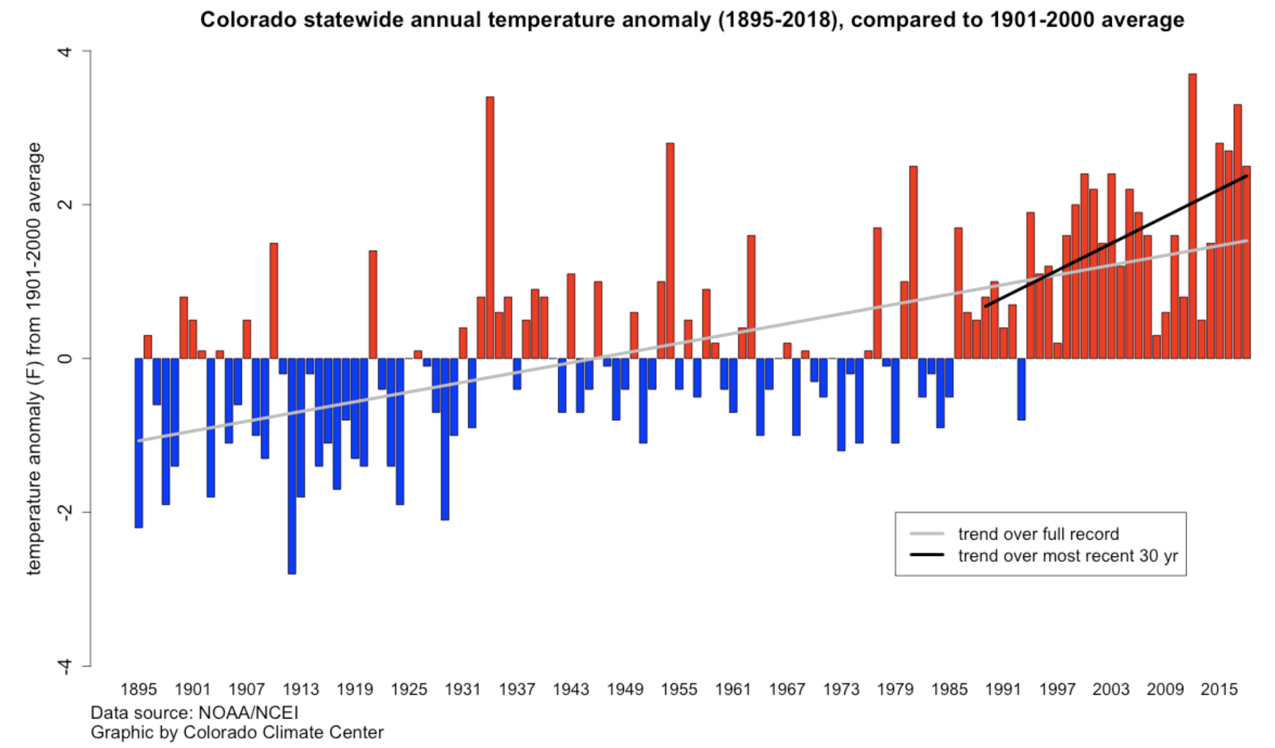

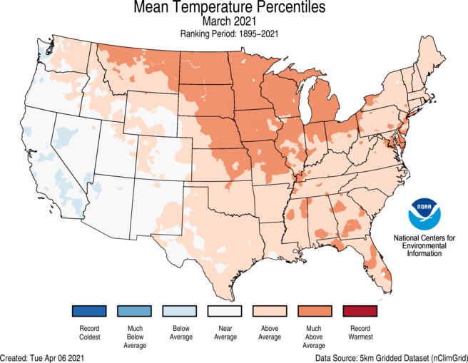
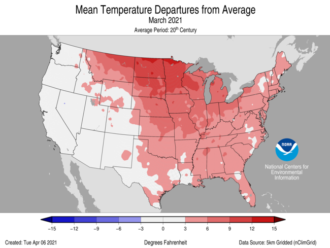
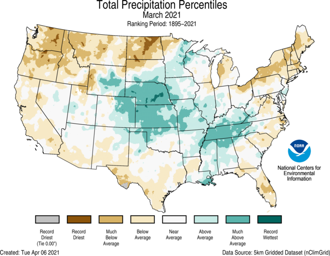
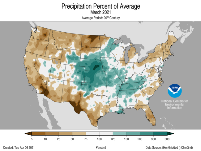
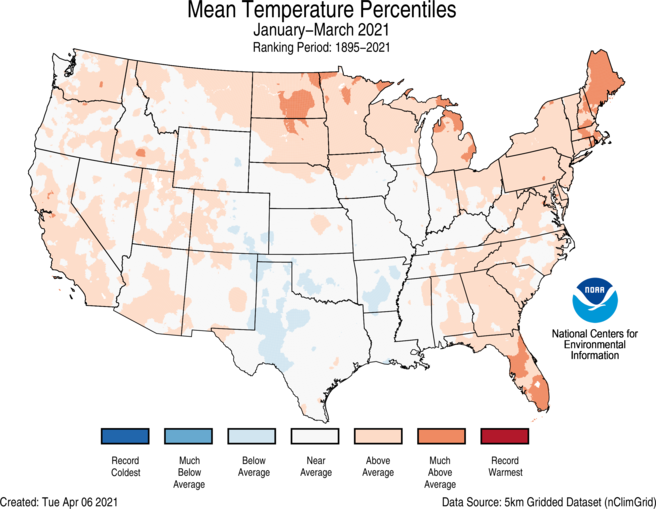
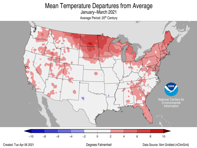
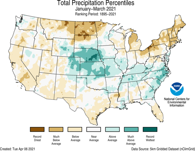
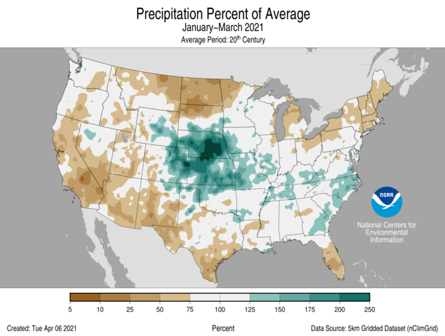

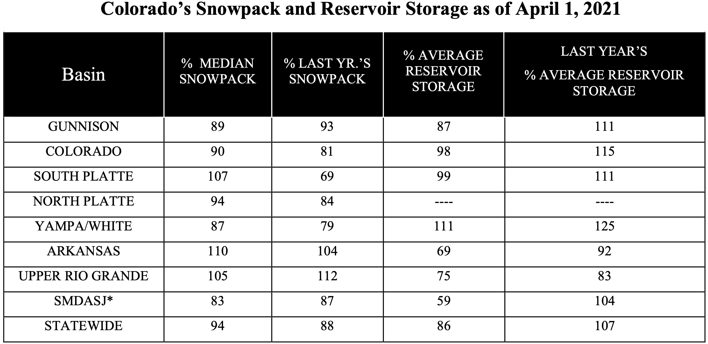


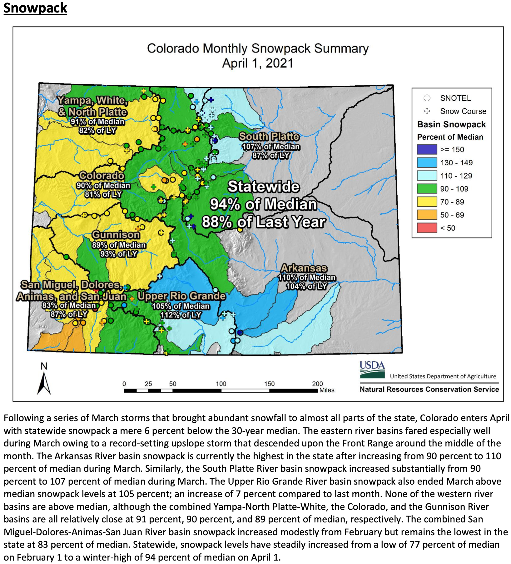
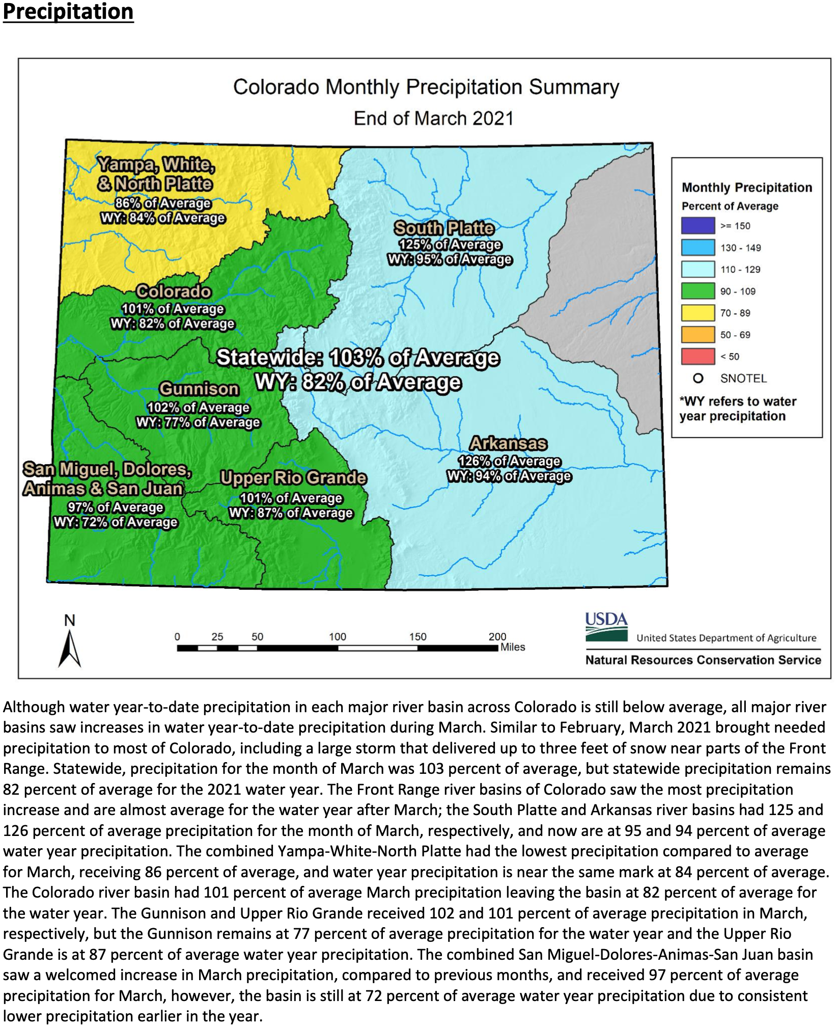
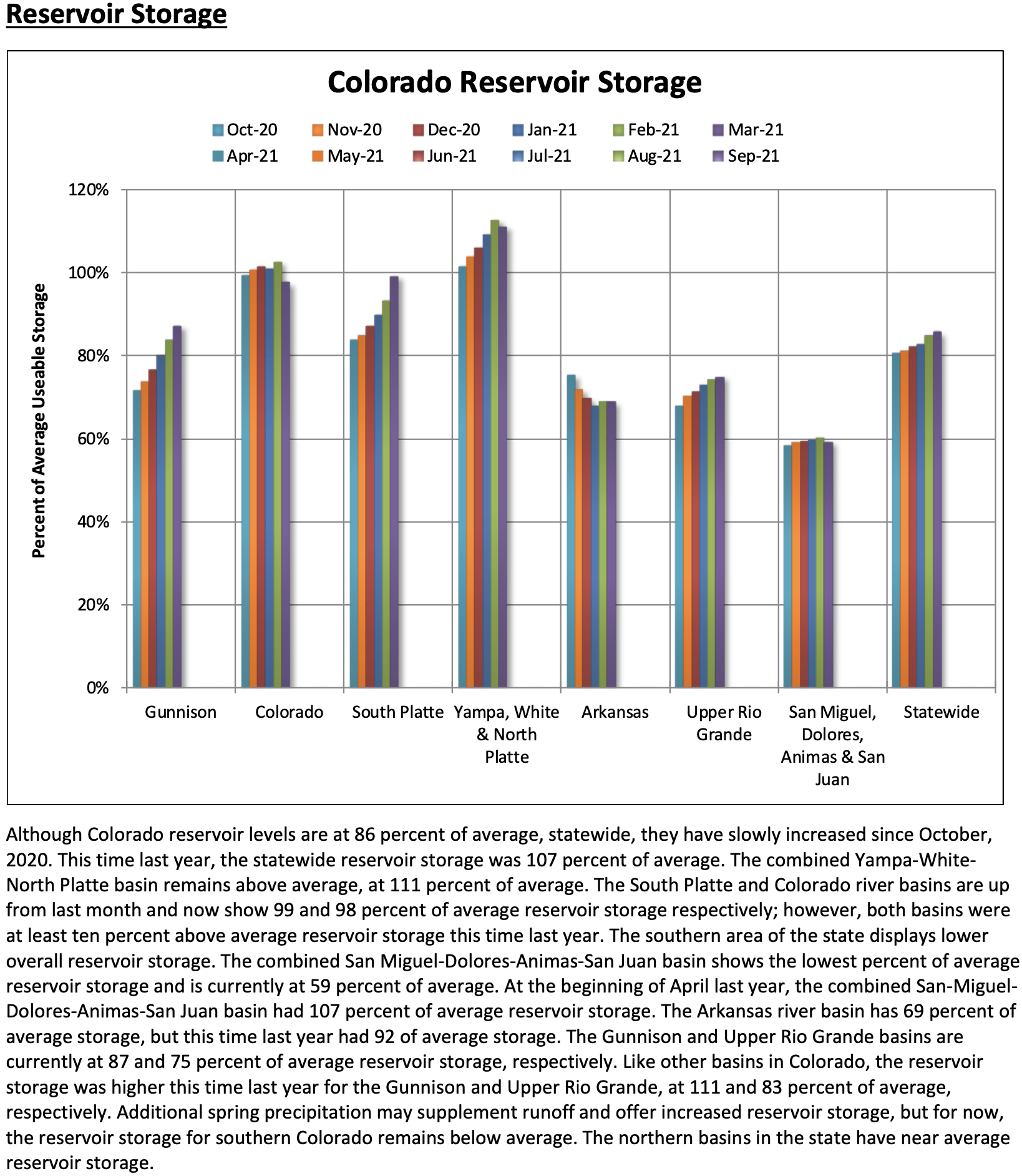
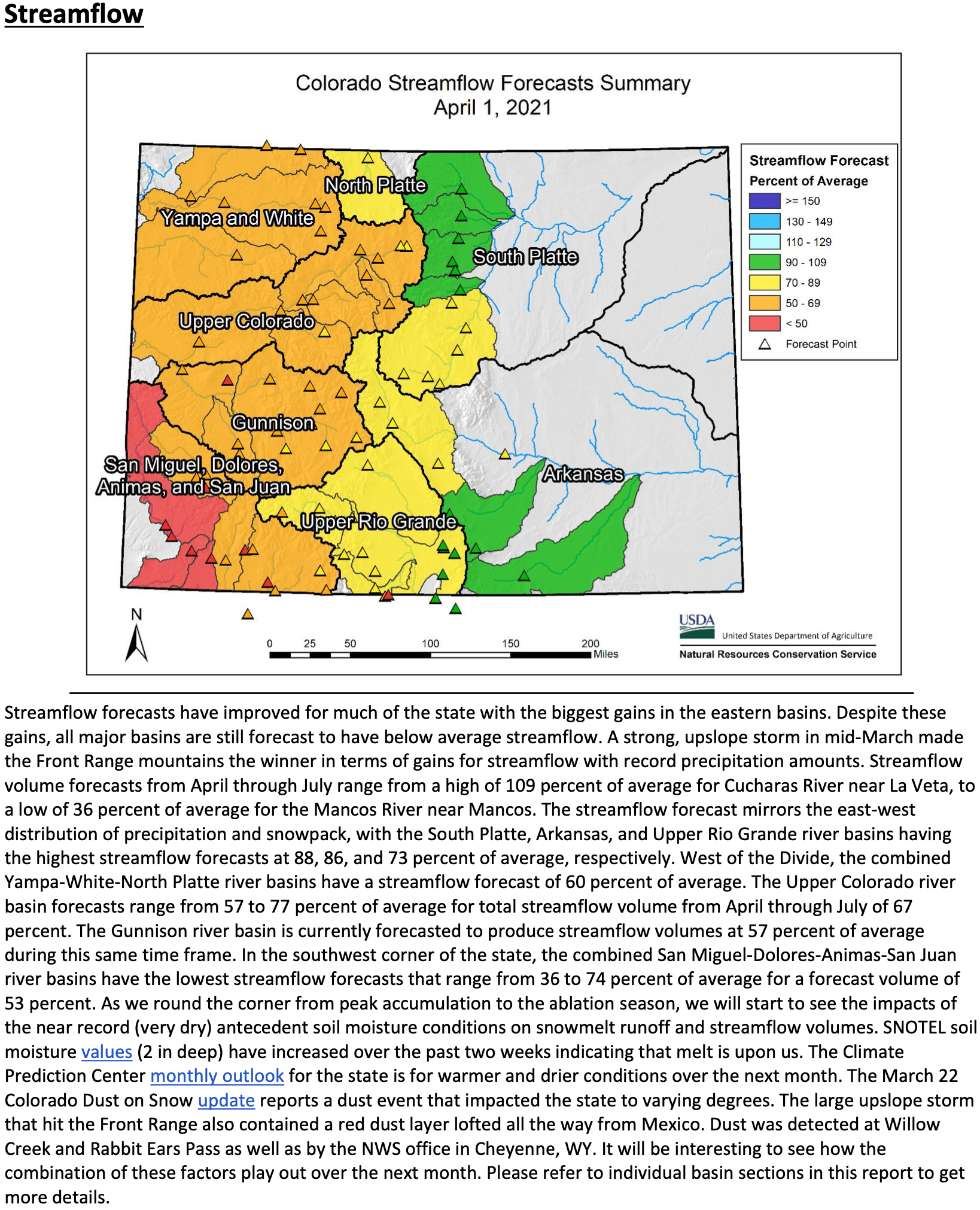


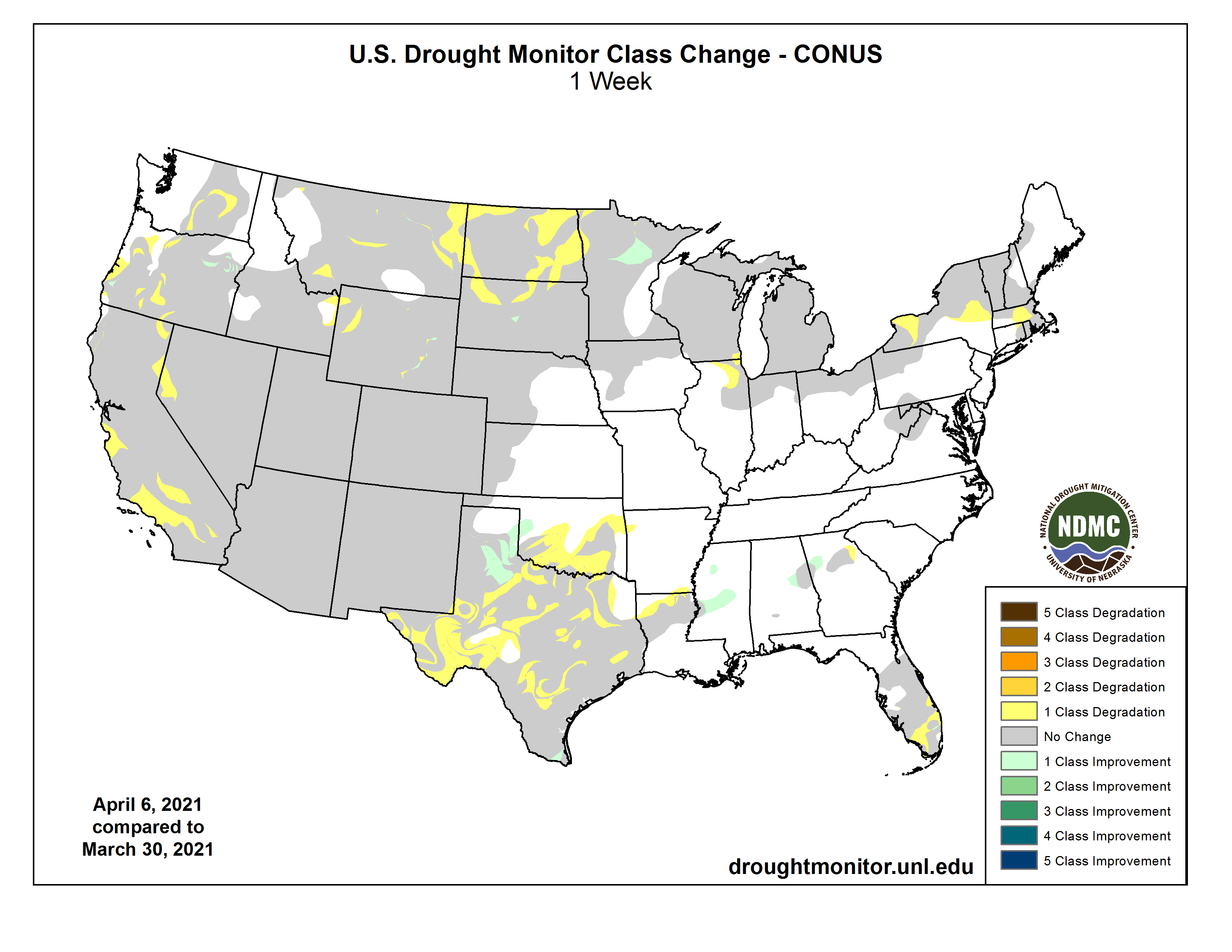
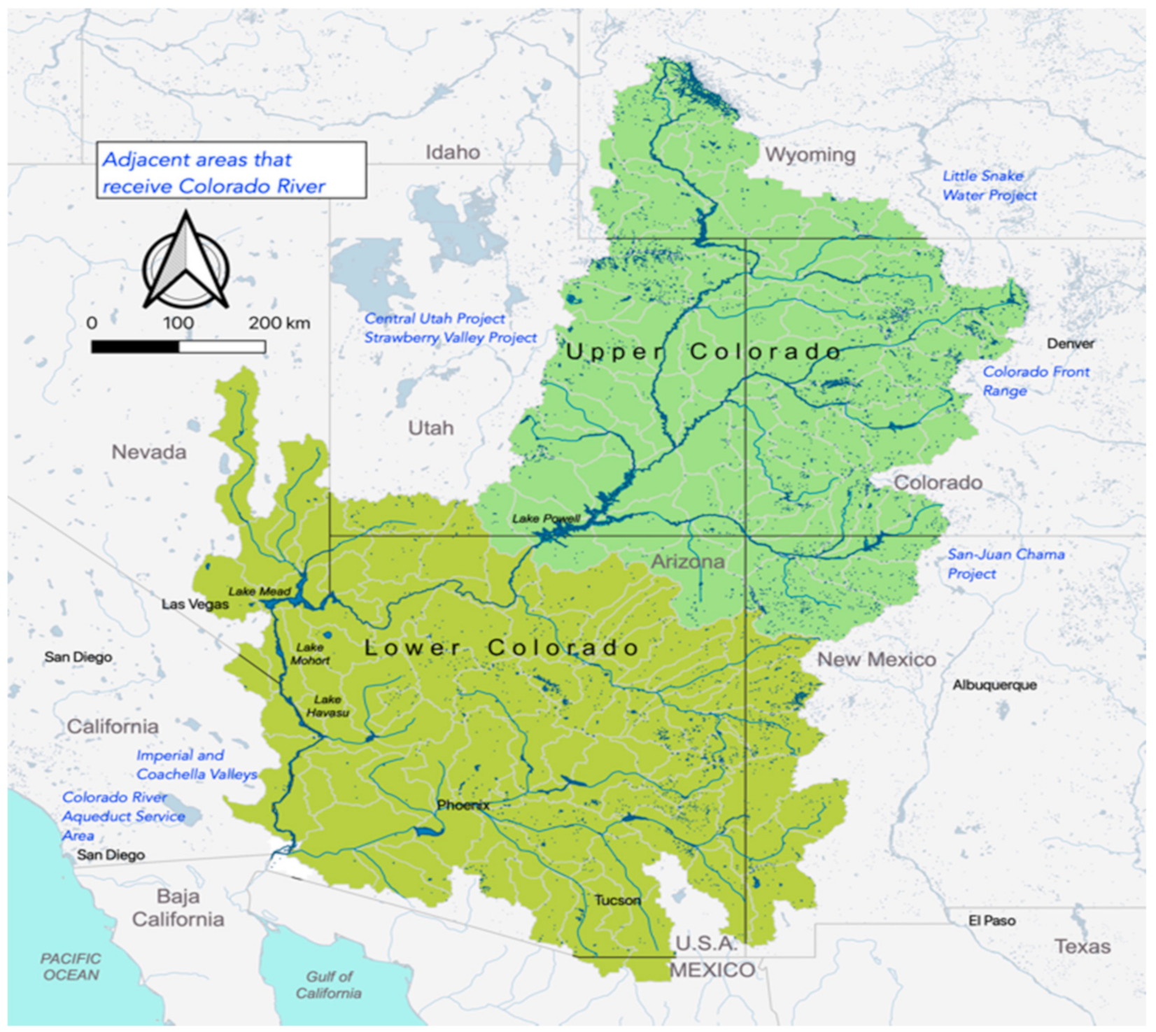

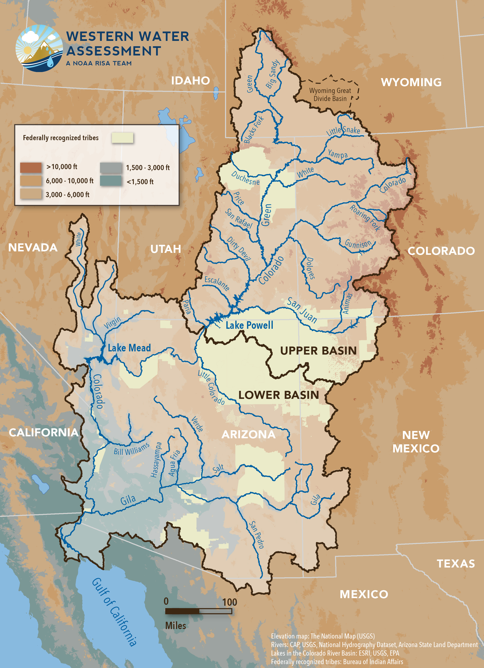


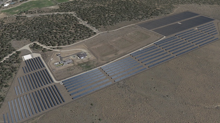
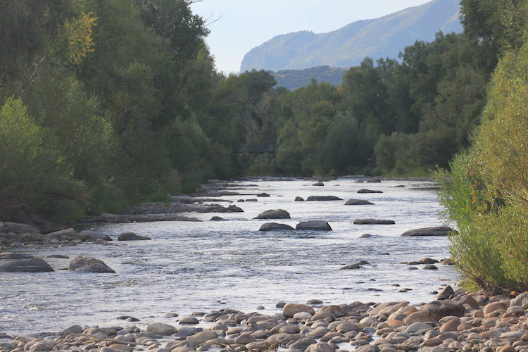
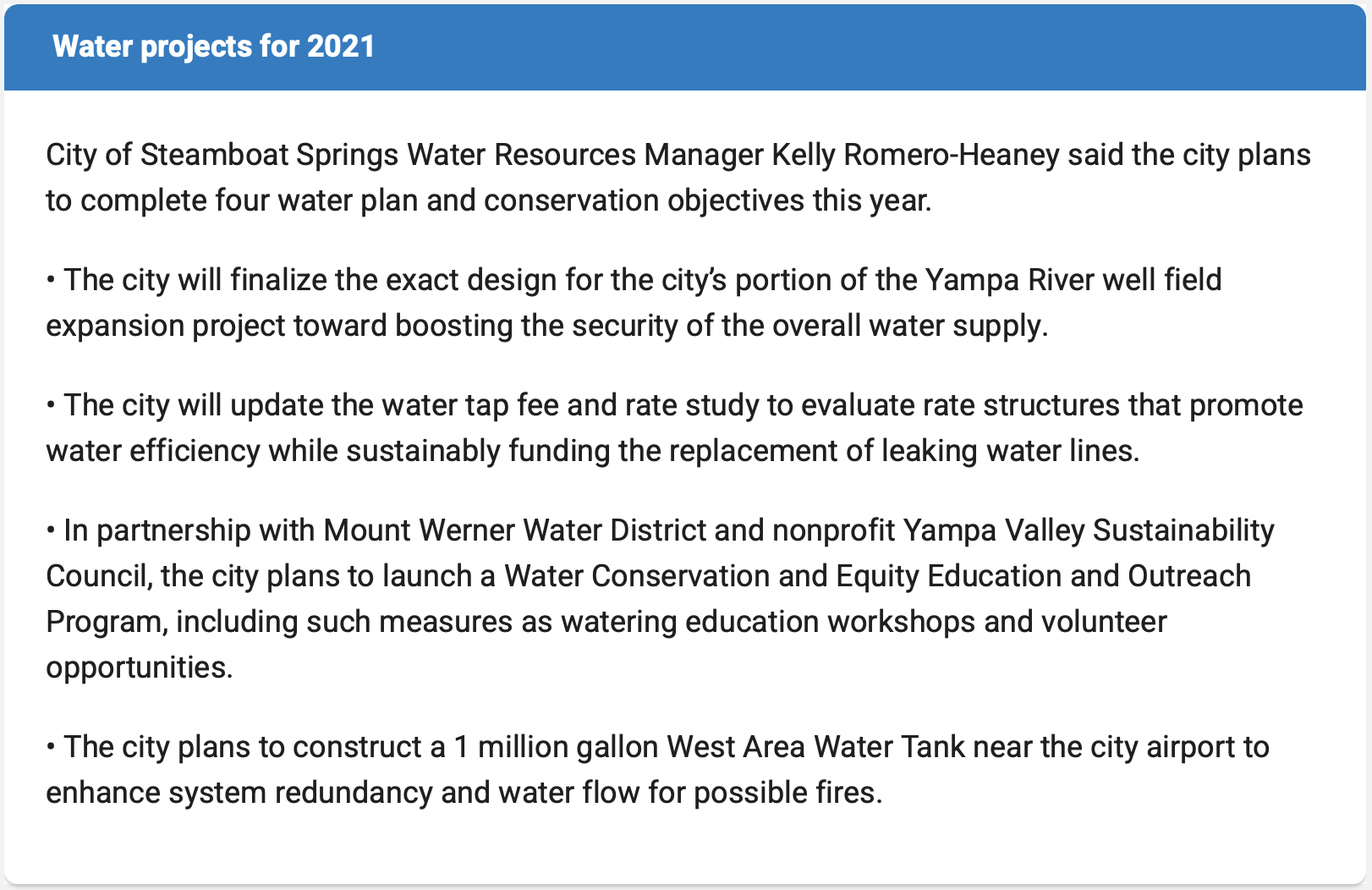


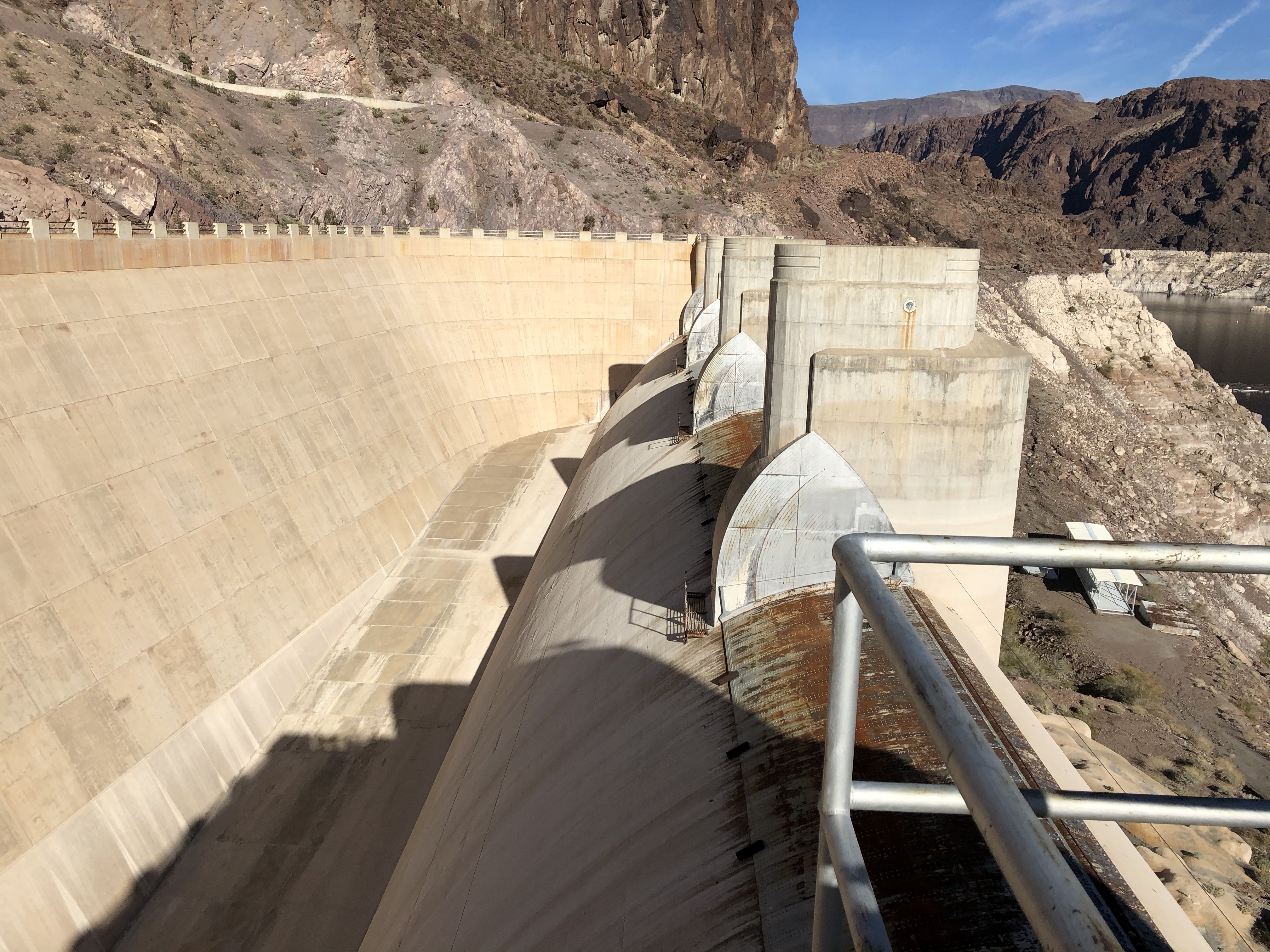


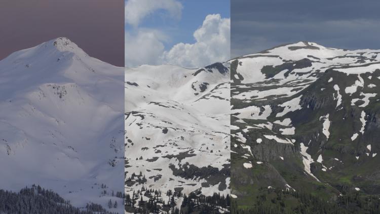


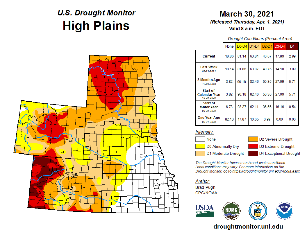


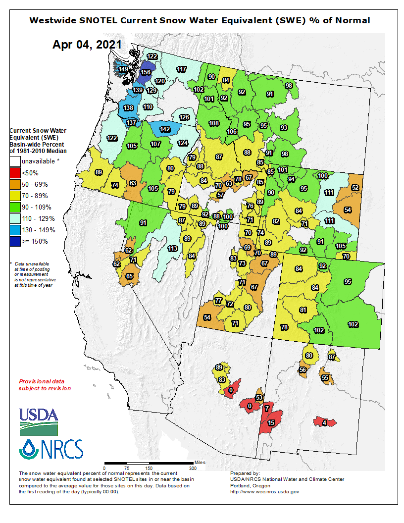


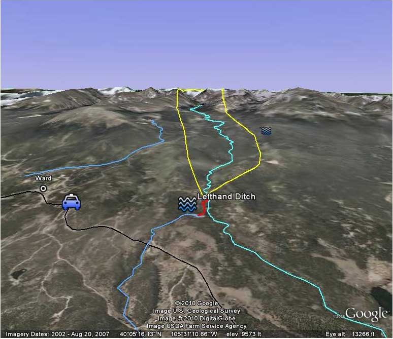
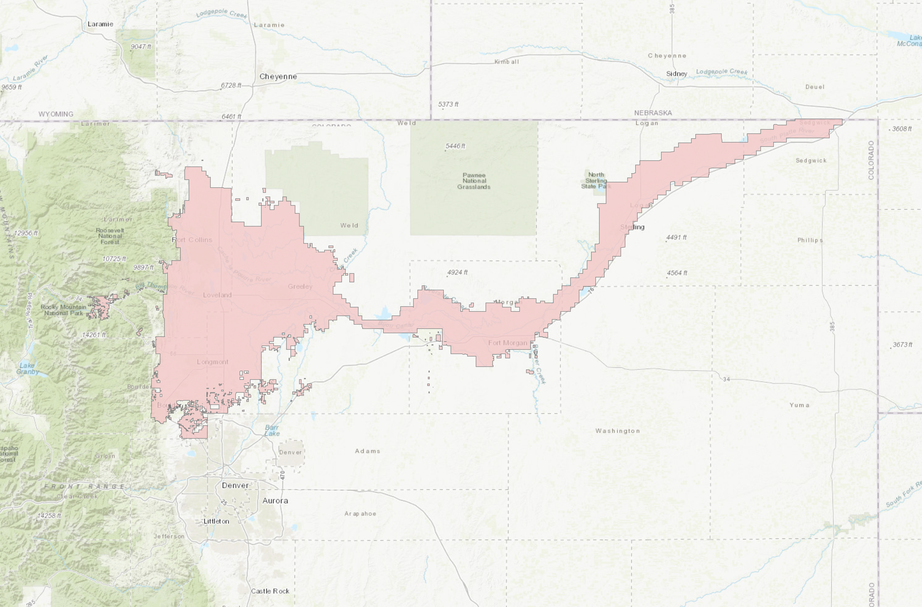
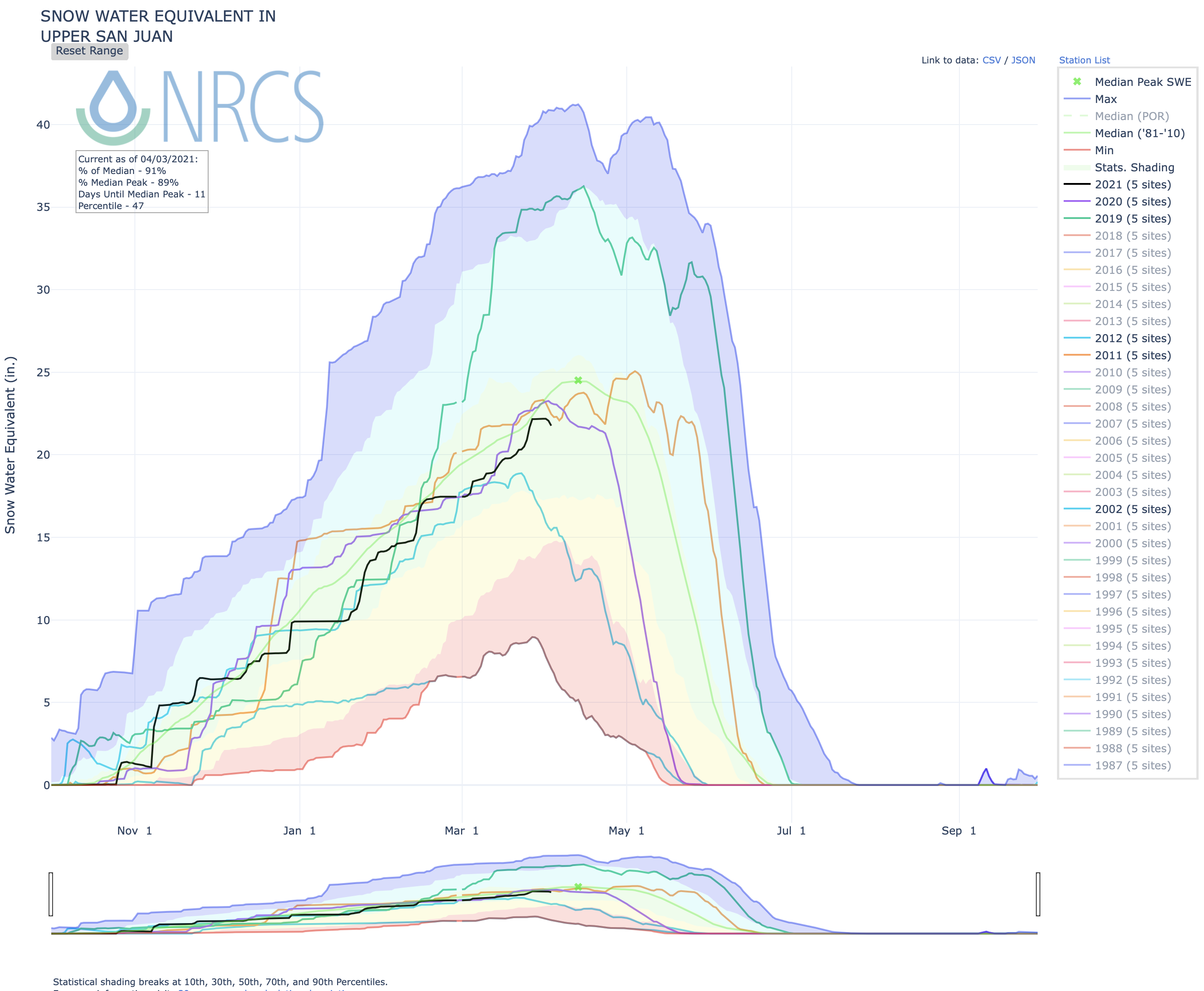

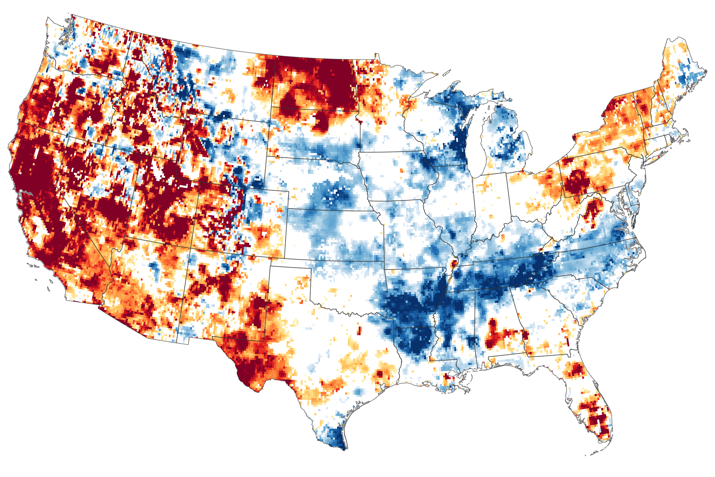
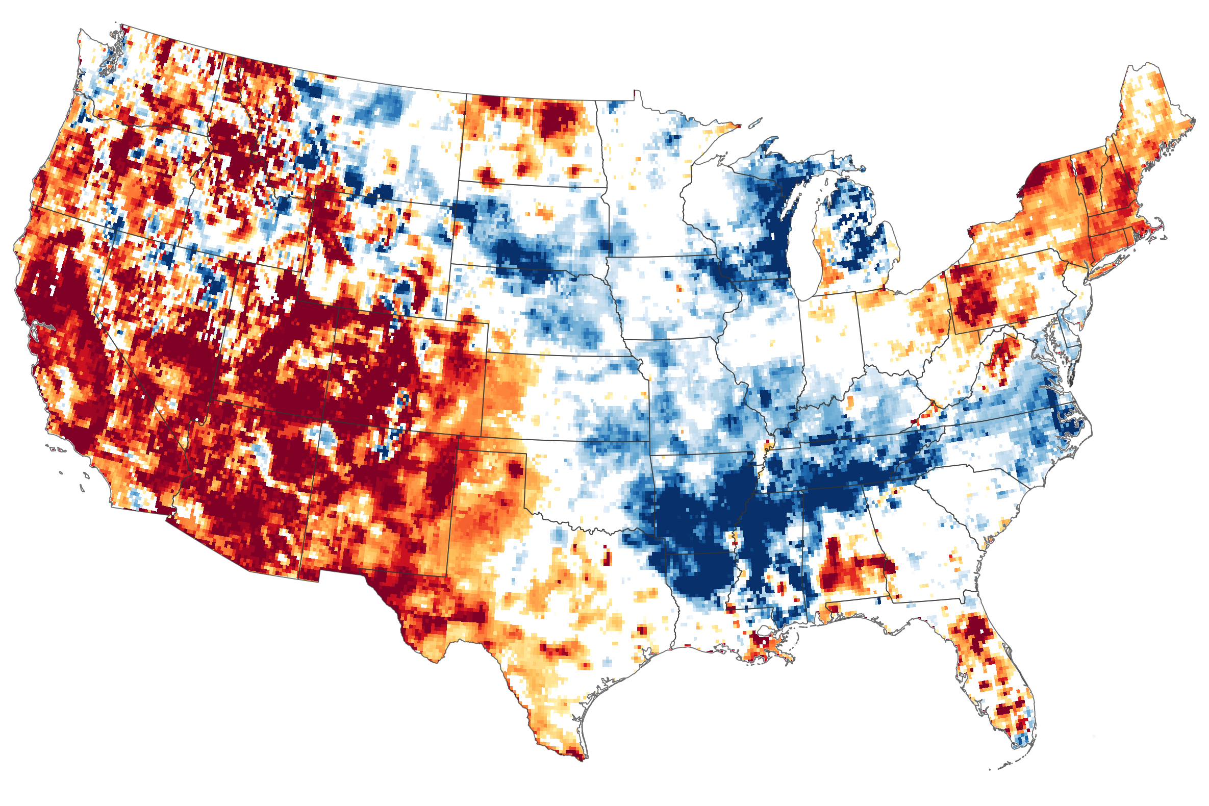
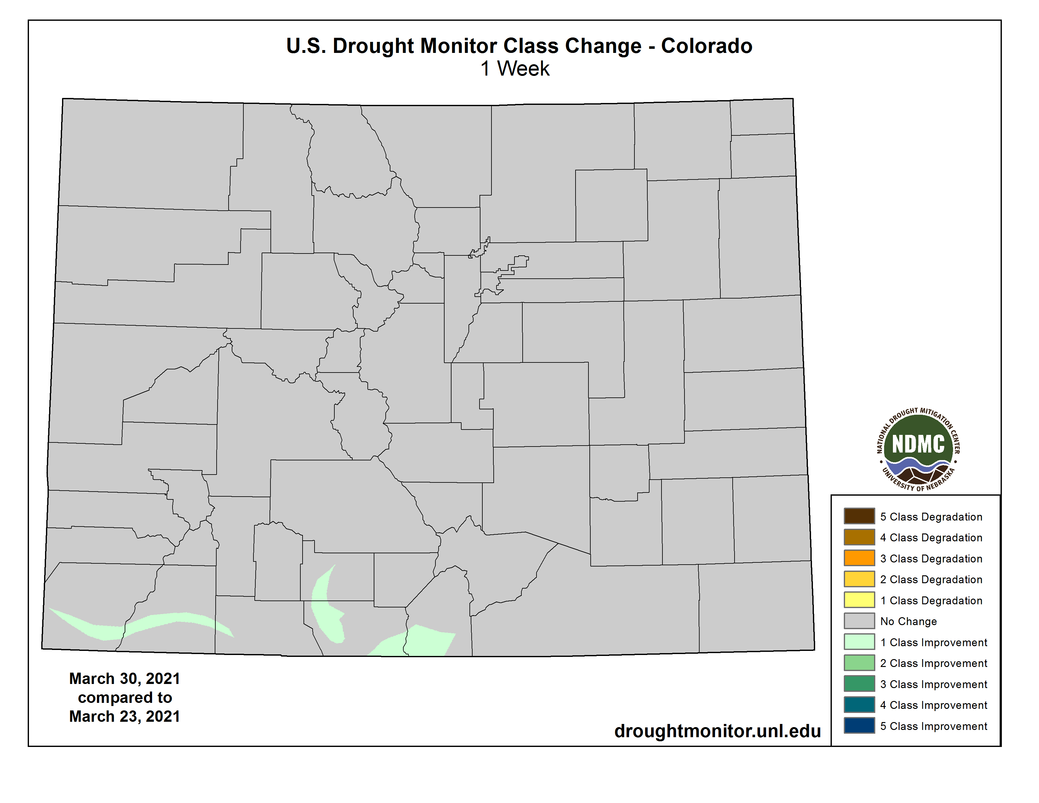
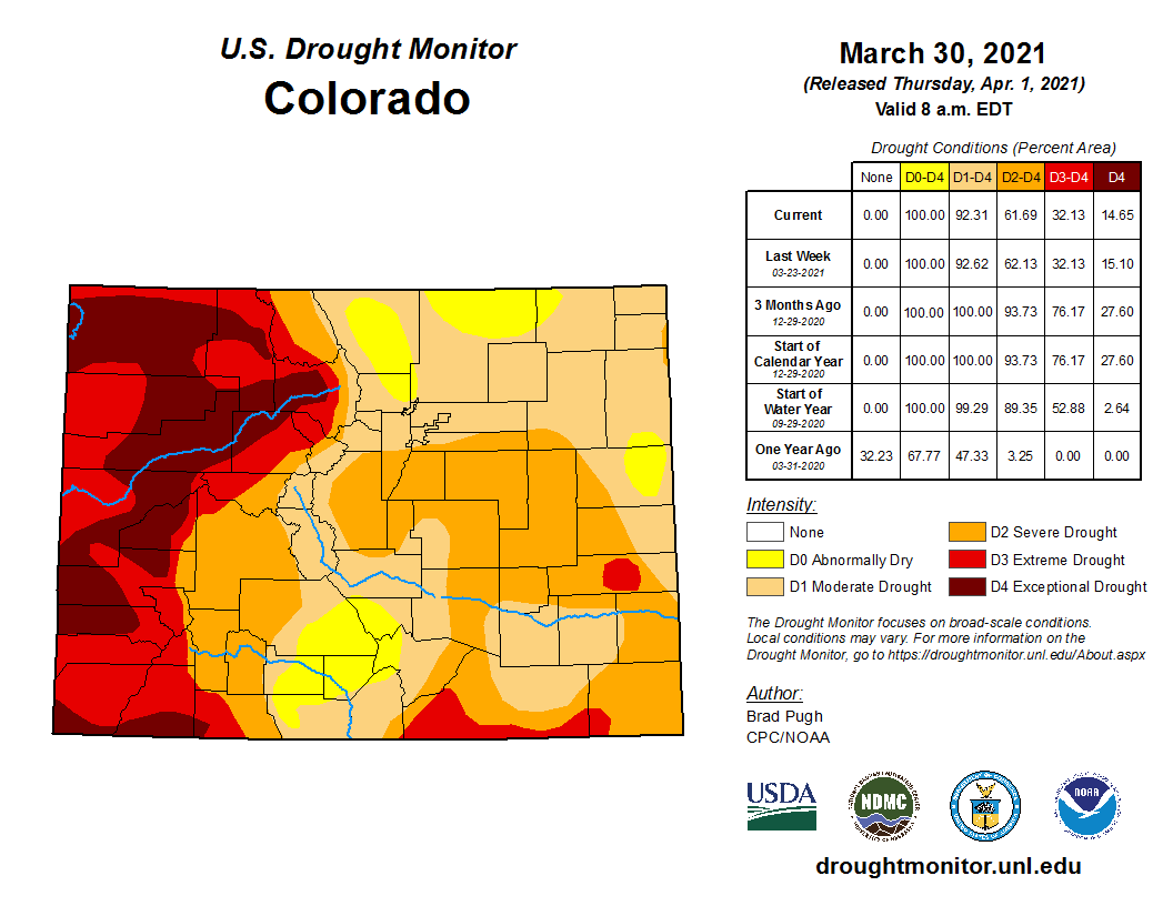


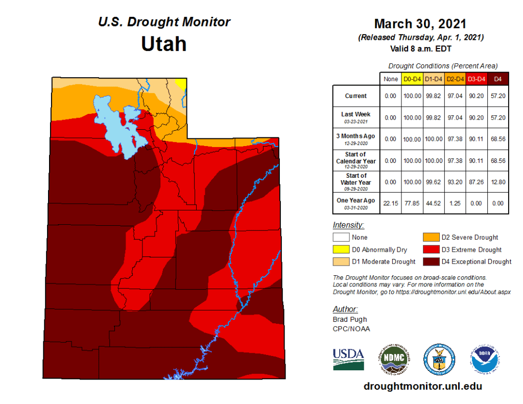


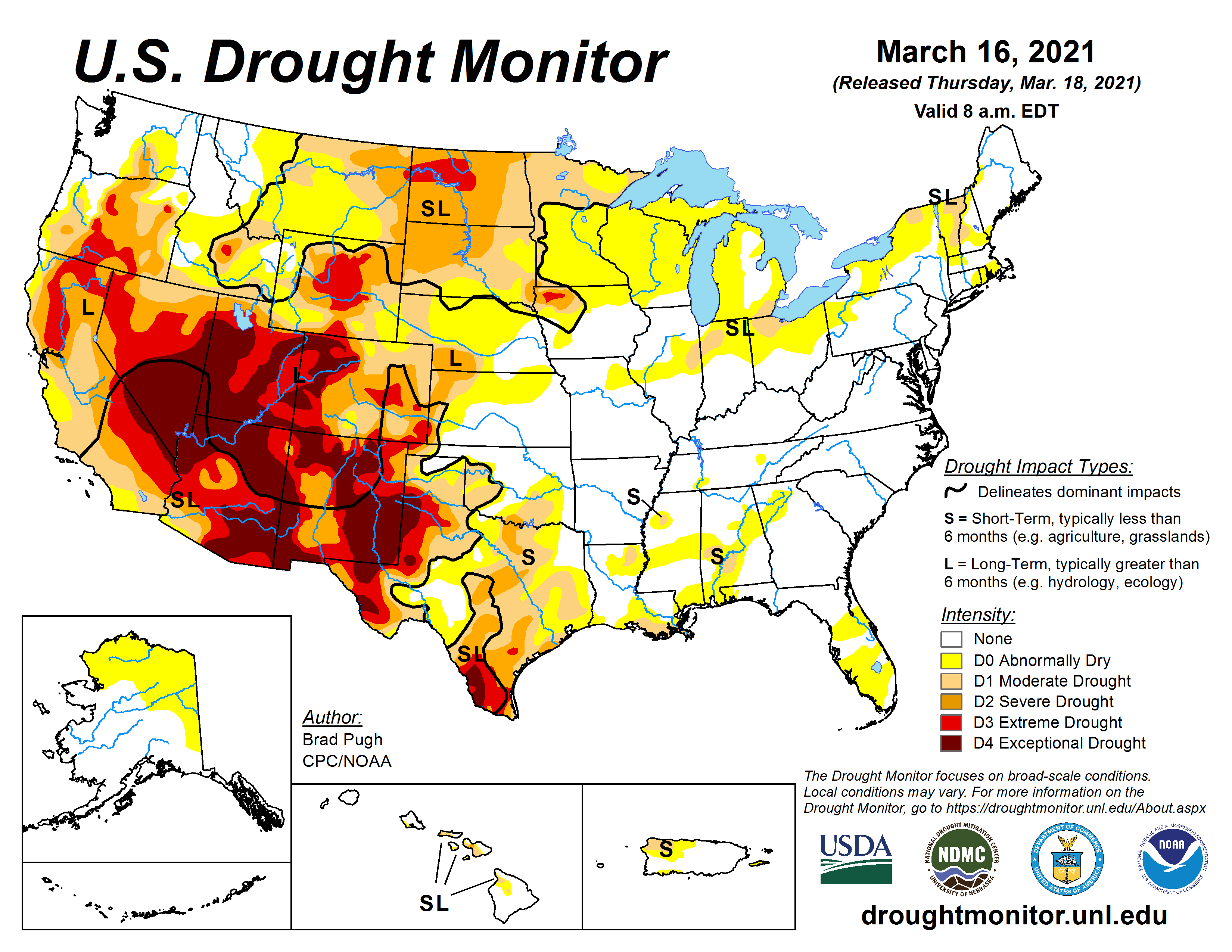
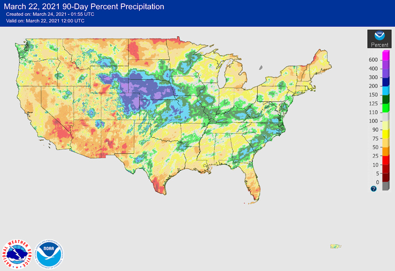
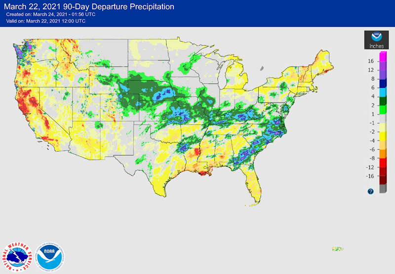
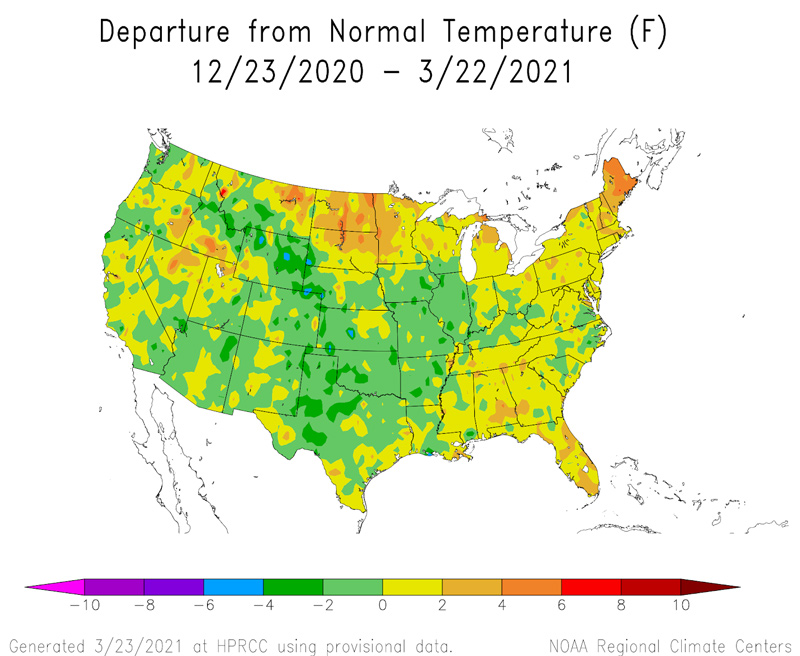
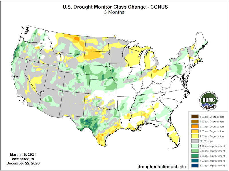
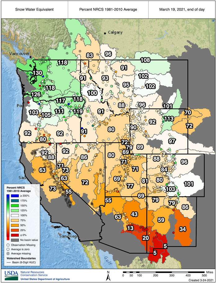
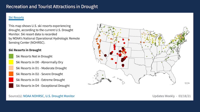


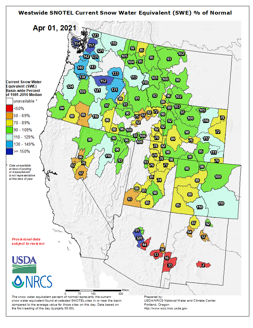


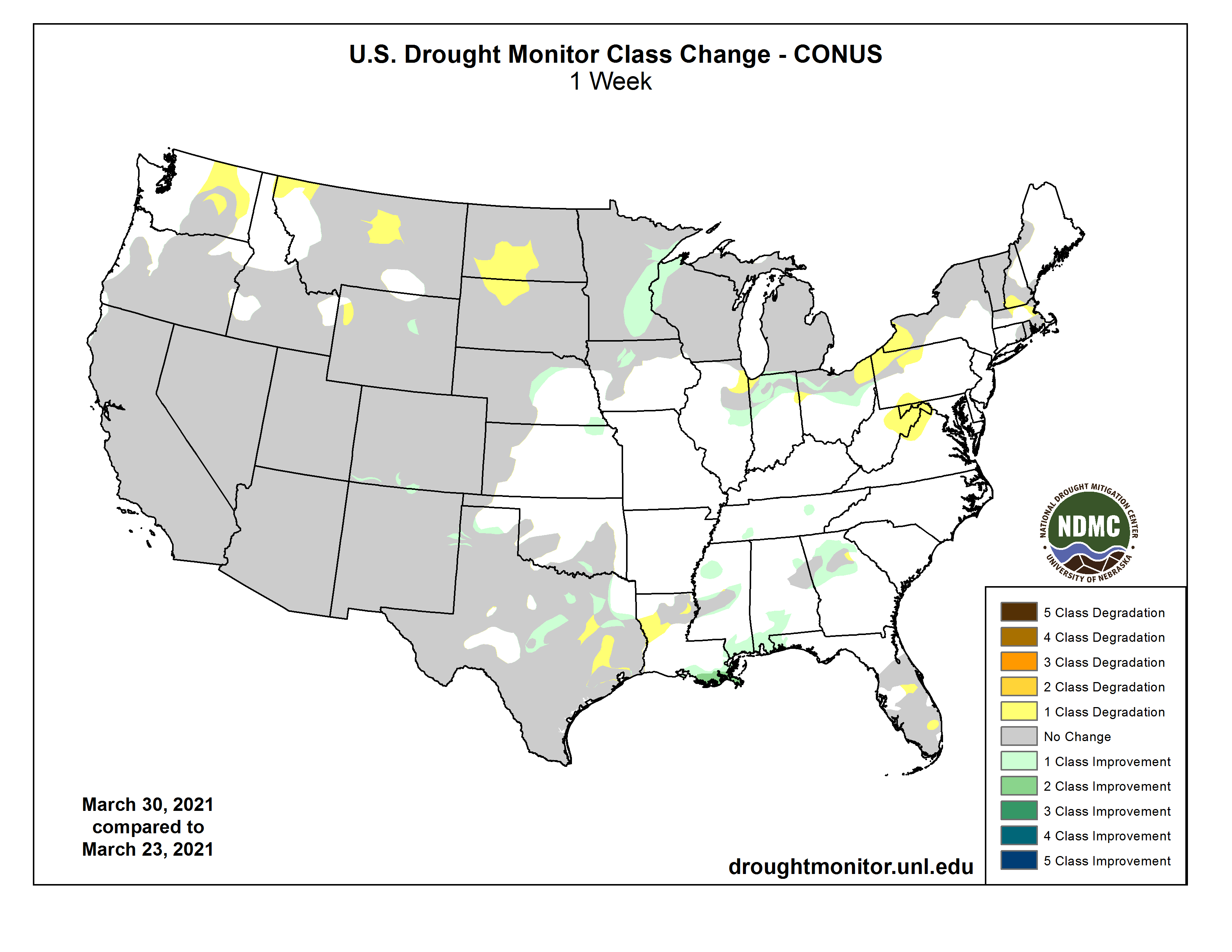
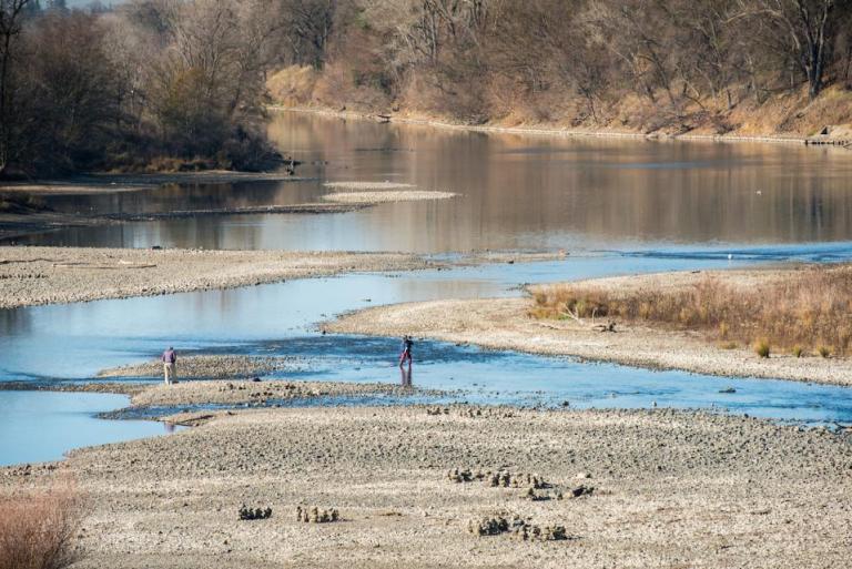
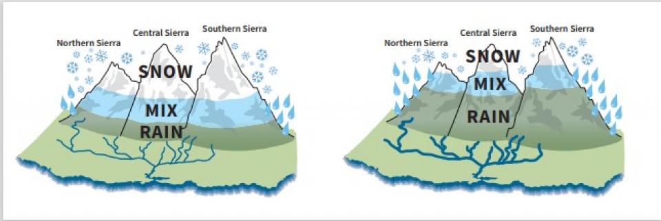


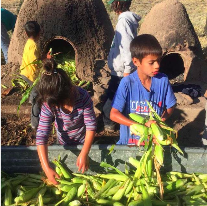
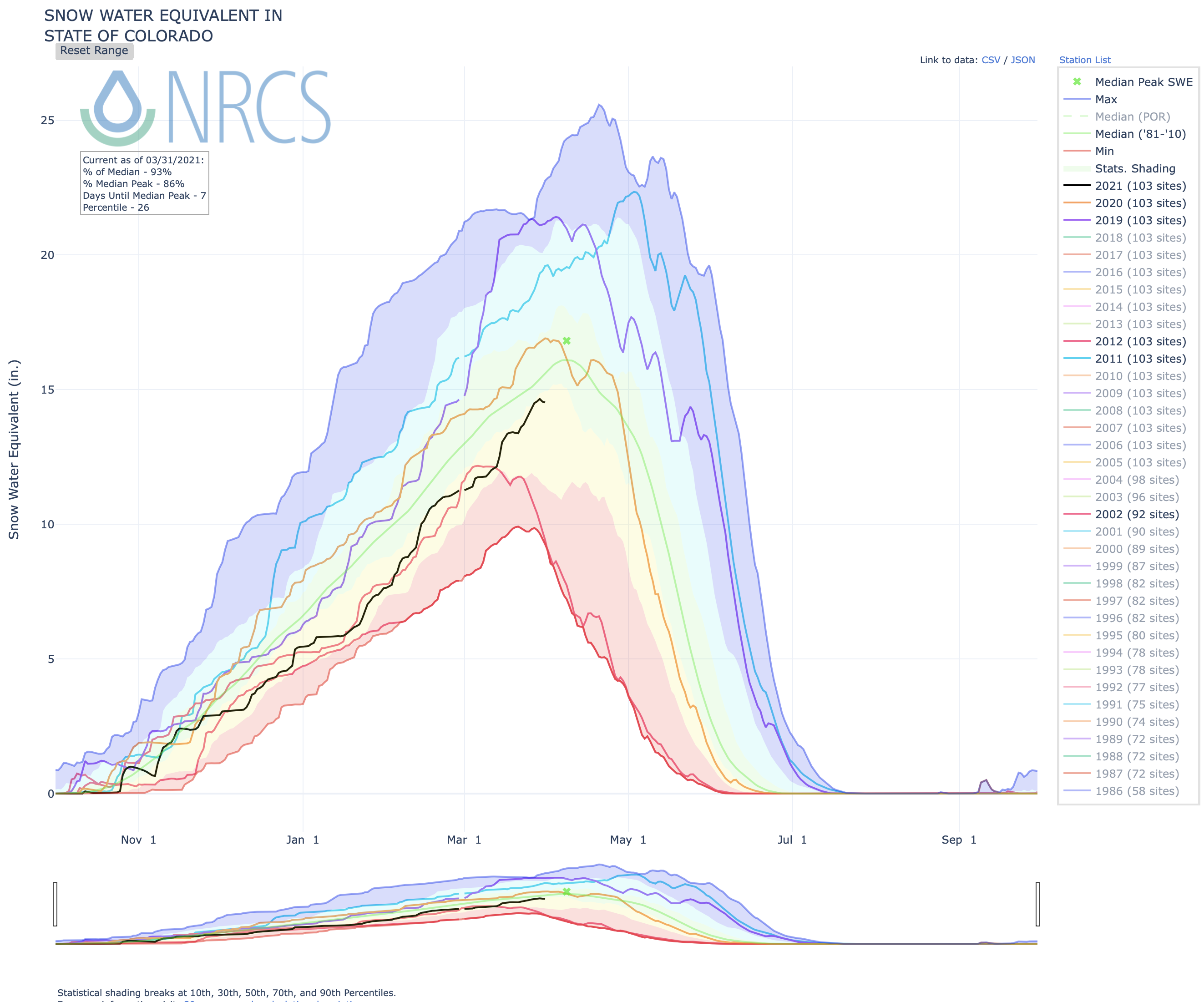