Click on a thumbnail graphic below to view a gallery of drought data from the US Drought Monitor website.


Click here to go to the US Drought Monitor website. Here’s an excerpt:
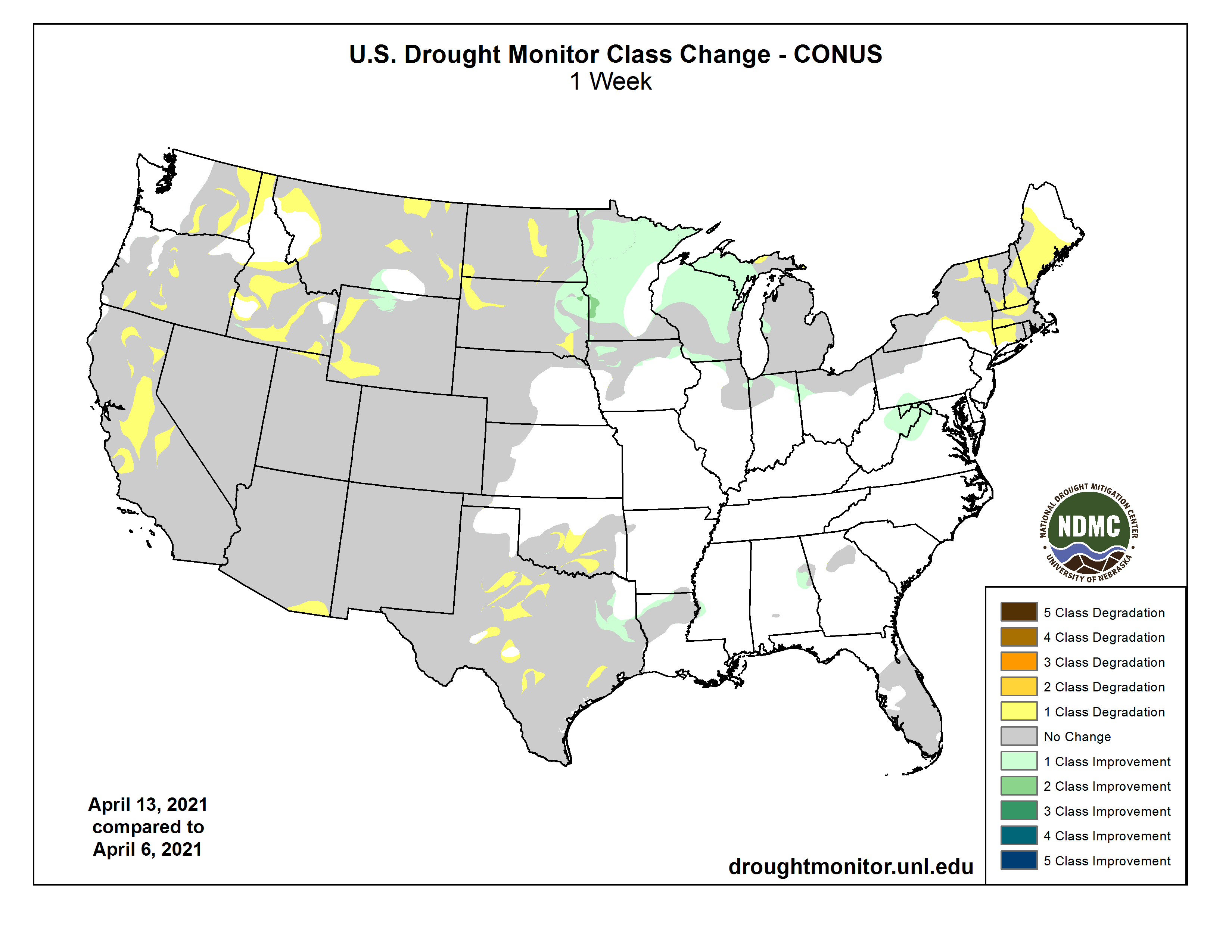
This Week’s Drought Summary
Last week’s storm system brought heavy rain and thunderstorms to much of the central and eastern U.S., bringing drought condition improvements to parts of the Midwest and eastern Plains. Meanwhile, warm, dry conditions persisted in the West and New England, resulting in deteriorating conditions. Parts of the Southwest are now experiencing record levels of dryness for the last 12 months. In New England, year-to-date precipitation ranks in the top 10 driest on record…
The High Plains generally saw cooler than normal temperatures and widespread precipitation over the last week. Locally heavy amounts of rainfall (more than 2 inches) helped erase long moisture deficits in eastern South Dakota and southeastern North Dakota, resulting in improvements to moderate drought. In the remainder of the region, precipitation wasn’t enough to prevent worsening conditions. Moderate drought (D1) expanded in South Dakota and extreme drought (D3) expanded in both North and South Dakota to reflect the growing moisture deficits and its effect on soil moisture. Agricultural field reports indicate planters are being idled, except in the southeastern corner of the state, and cattle are being culled…
Once again this week, much of the West remained dry. Where precipitation did fall, in the Pacific Northwest and the Northern Rockies, it either missed the drought-inflicted areas or wasn’t enough to overcome shortages. The only exception was in north-central Wyoming and southern Montana, where last week’s snowfall lessened precipitation deficits and improved streamflow and soil moisture resulting in a one-category improvement to drought. In eastern Washington, D0 (abnormally dryness), D1 (moderate) and D2 (severe) drought expanded as precipitation deficits continued to increase, drying out soils and lowering streamflow. Conditions once again deteriorated in Oregon this week with expansions in D2, D3 (extreme) and D4 (exceptional drought). The warm, dry winter added to deficits that had been in place for more than a year, leaving soils extremely dry and limiting runoff. Crop condition reports that counties in the D3 and D4 regions are “heading into their worst water year ever for irrigators with the potential for large amounts of acres left fallowed.” Little to no water for irrigation is expected for Upper Klamath Lake this year. Similarly, drought also expanded in Idaho where a lack of precipitation for almost two months has limited runoff, resulted in earlier than normal snowmelt and put short-term precipitation below the 10th percentile at many locations. Drought conditions also expanded in northern and central California. Another week without rainfall has continued to build upon longer deficits. Cooperative Extension notes that the majority of the season’s creeks aren’t flowing and that stock ponds are still dry. Decreases in water allocation and reduced or negligible forage are causing producers to respond by culling and selling herds. Drought conditions are also prompting Cal Fire to bring in fire crews earlier in the season. Other changes to this week’s map include an expansion of D1 in western Wyoming, and D1, D2 and D3 in eastern Montana reflect the lack of precipitation over the last two to three months and its effect on soil moisture and streamflow. In the Southwest, D4 was expanded over southeast Arizona as another week of hot, dry weather showed its impact on streamflow, soil moisture, and vegetation. It’s worth noting that high temperatures ranged from 10 to 20 degrees above normal last week and that many areas are now at record dry levels for the past 12 months…
Showers and thunderstorms across the South last week led to slight improvements to D0 (abnormally dry) and/or D1 (moderate drought) in Louisiana and East Texas. While the rain helped some, shortages still exist at 60 to 90 days. Having missed out on the rainfall, conditions continued to deteriorate in south-central Oklahoma and in North, South and West Texas, where another week of warm, dry weather continued to build long-term deficits and further dried out soils…
Looking Ahead
The National Weather Service Weather Prediction Center forecast for the next five days (April 15-19) shows slow moving storm systems affecting large parts of the Lower 48. This storm is expected to bring cold temperatures and late season snows across the Northern Plains, Central Rockies and Northern Great Basin. In the Southwest, dry weather combined with gusty winds is expected to persist, leading to an elevated fire risk. In contrast, the Lower Mississippi Valley and eastern Gulf Coast states are expected to see heavy rainfall. Moving into next week, the Climate Prediction Center six to 10 day outlook (valid April 19-23) favors above normal temperatures across the West, Northeast and Southeast. Below normal temperatures are most likely across the Great Plains, Midwest and Mississippi Valley. Below normal precipitation is expected across much of the country with the exception of the Southern High Plains, Florida and New England.