The health of our waters is the principal measure of how we live on the land — Luna Leopold
The Pagosa Area #Water and Sanitation District implements voluntary #drought restrictions — The #PagosaSprings Sun #SanJuanRiver #ColoradoRiver #COriver #aridification
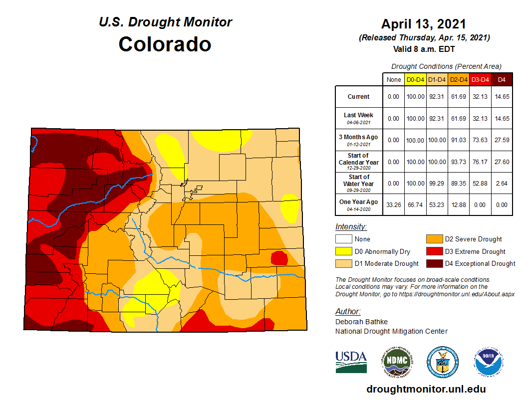
Colorado Drought Monitor April 13, 2021.
FromThe Pagosa Springs Sun (Clayton Chaney and Randi Pierce):
The Pagosa Area Water and Sanitation District (PAWSD) is asking water users to practice responsible water use, with the district currently in a voluntary drought stage in compliance with its 2020 Drought Management Plan.
According to a press release from PAWSD District Manager Justin Ramsey, “The primary driver of this drought stage is the U.S. Drought Monitor (USDM),” which indicates that “our area is in a Severe to Extreme Drought.”
Ramsey’s press release notes that Hatcher Lake is lower than the median volume for this time of year, “however the lake is currently filling.”
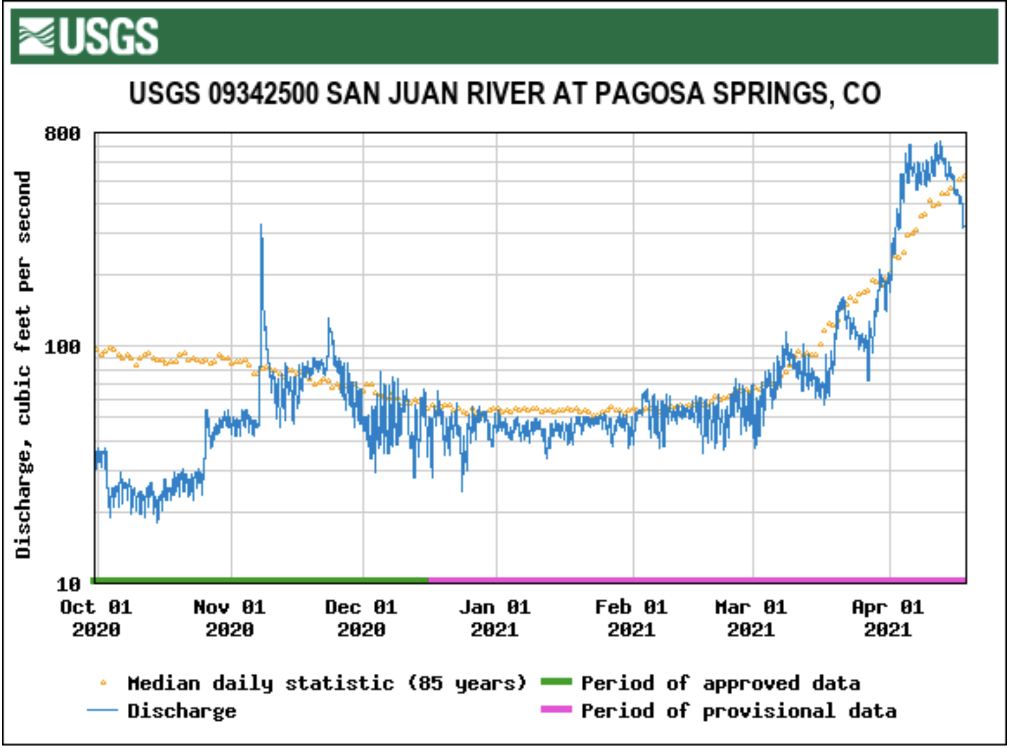
“The flow of water in the San Juan is currently above the median flow for this time of year,” the press release further notes.
Ramsey also noted in his press release that so far this spring Pagosa Country has seen higher-than-normal temperatures.
He explained that the higher-than-normal temperatures combined with “a reduction in late spring precipitation will lead to a quicker-than-normal melting of the snowpack,” which will reduce the volume of available water and “could lead to water use restrictions.”
According to the press release, there are no mandatory water use restrictions, “however PAWSD does encourage responsible water use.”
[…]
River report
According to the U.S. Geological Survey (USGS), the San Juan River was flowing at a rate of 606 cubic feet per second (cfs) in Pagosa Springs as of 10 p.m. on Tuesday, April 13.
Based on 85 years of water records at this site, the average flow rate for this date is 514 cfs.
The highest recorded rate for this date was in 1985 at 1,930 cfs. The lowest recorded rate was 120 cfs, recorded in 1977.
As of 10 p.m. on Tuesday, April 13, the Piedra River near Arboles was flowing at a rate of 492 cfs. Based on 58 years of water re- cords at this site, the average flow rate for this date is 784 cfs.
The highest recorded rate for this date was 2,600 cfs in 1985. The lowest recorded rate was 128 cfs in 1977.
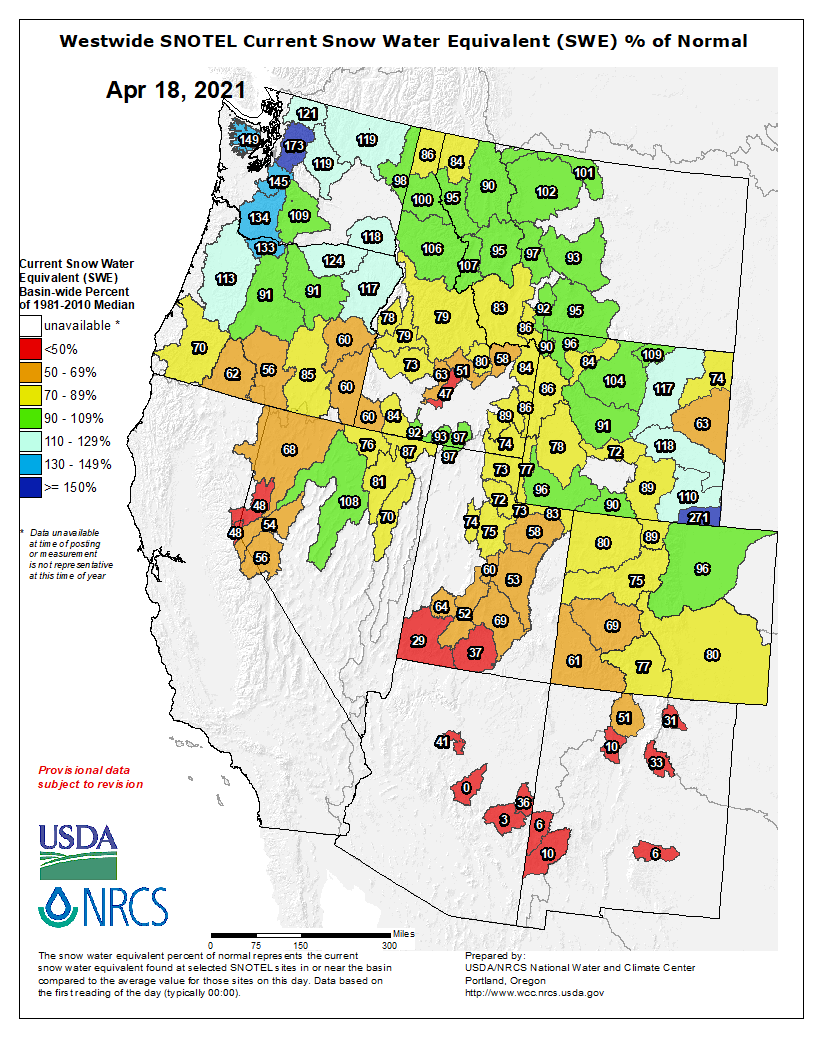
Westwide SNOTEL basin-filled map April 18, 2021 via the NRCS.
Snow report
According to the U.S. Department of Agriculture National Water and Climate Center’s snowpack report, the Wolf Creek summit, at 11,000 feet of elevation, had 33.8 inches of snow water equivalent as of 10 p.m. on April 13.
That amount is 79 percent of the April 13 median for this site.
The San Miguel, Dolores, Animas and San Juan River basins were at 61 percent of the April 13 median in terms of snowpack.