Someday, this article won’t have to be written. Someday, projects won’t need to be highlighted specifically because women are leading them. Someday, we will get to the point where we won’t have to ask what it’s like being a woman working alone in nature or the only woman in a boardroom. Someday, we will have greater gender equity in conservation.
To get to that day, it is important we elevate the women doing amazing conservation work so that other women will realize, “I can do that, too.”
(THERE’S NO CONSERVATION WITHOUT WOMEN (2:00) As the first woman to be CEO of The Nature Conservancy, Jennifer Morris has seen how frequently women and people of color have been absent from conservation decision making. Representation matters for women, for conservation, and for our future.)
The Nature Conservancy has example after example of women rising above barriers—which is especially incredible given that the global pandemic disproportionately impacts women—to do what it takes in the name of conservation:
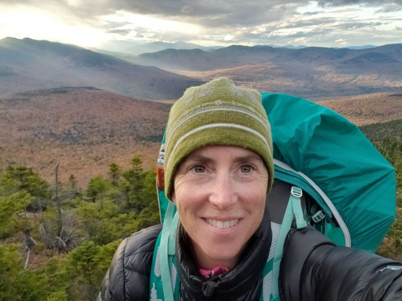
The woman who hiked stormy mountains alone for weeks to collect pine needles for genetic testing.
The women who practically lived underwater for days to repair coral reefs.
All of the women who, for a full year now, have managed their work from makeshift home offices, while sometimes caring for their sick family members, teaching their children, and trying to keep loved ones healthy and sane.
TNC is earnestly working towards a more equitable future that welcomes and promotes women and other underrepresented groups. Like any large organization, we may stumble along the way. But we’re proud to have hired our first female CEO, first female Chief Scientist, and the roughly 40% of our directors and issue experts who are women.
We recognize that, often, when gender is highlighted it’s typically to help advance specific conservation goals. We choose to discuss the science of conservation and highlight our brilliant scientists regardless of gender. Nevertheless, we are proud that many of our scientists identify as female, and that they bring their own valuable and diverse perspectives to our work.
A 30-year chain of mentoring uplifts generations of women in science
“I don’t get the sense that younger women are as conscious of their gender in the workplace as I needed to be 30 years ago,” says Samantha Horn, Maine’s Director of Science. “But the transition from outright prohibition of women in science, to hazing, to women being seen as exceptions, to being accepted as normal took a century.”
Horn is part of what she calls a chain of mentoring: recognizing the perseverance of the women who came before her and helping to advance the women who come after her. She remembers hearing about the awful treatment her mentors had to put up with simply for being a woman in science. Like being told to their faces, “you’re a woman, you’re not allowed to have this job.”
One of her mentors, Sandy Ritchie, never had a mentor who was a woman. When she started as a biologist with the Maine Department of Inland Fisheries and Wildlife in the 1980s, Ritchie was one of only two women. Over her 31-year career she learned to navigate gender-based hiring and promotion practices (including turning down a promotion that she learned was given not for merit, but for gender), comments and actions from male biologists that would now be recognized as sexual harassment, and worked up to a senior level position, paving a path for Horn and other women to follow.
Horn is proud of her mentor for handling the comments and treatment with strength and grace, and appreciates that she persevered for the next generation. And while she feels lucky she didn’t have to go through some of those same challenges, it still wasn’t smooth sailing for her. Horn believes the next evolution is that both men and women will feel like it’s completely normal for a woman to be a scientist, not that it’s a new challenge or that a woman who is a scientist is special.
Horn, in turn, mentors Molly Payne Wynne, the Freshwater Program Director for TNC in Maine. Payne Wynne says it can be challenging to show up as your full self in a room full of men with preconceived notions about women in science. “Women are still outnumbered in fisheries meetings, but it’s getting better,” she says.
Payne Wynne believes young women and girls need to see women in science positions so they will think, “I, too, can be a scientist.” She wants her young daughter to know she can be anything she wants to be. “I pay attention to books and movies that show women in traditionally male jobs,” she says. “I want her to know that ‘scientist’ or ‘forester’ are inclusive of women.”
Back when she was starting out, Ritchie never had the goal of breaking into a male-dominated profession. She just loved the work and always knew that’s what she wanted to do. That said, she believes in the power of hiring for diversity.
“I think in the beginning some men were concerned whether women could physically do the job,” she says. “Working alone in remote areas, in adverse weather conditions, and handling heavy equipment and the occasional unwelcome moose was all part of the job. As more women were hired, we proved that what we may have lacked in physical strength we made up for with ingenuity and perseverance.”
Today, Payne Wynne uses social media to connect with an extensive support network of women in fisheries all across the world. In these online groups, women can get help with everything from navigating sexual harassment in the workplace to finding wetsuits and other field gear that’s made for women’s bodies.
“I think it’s very different for this generation of women scientists compared to previous generations,” she says. “These groups help me navigate and embrace what it means to be a woman in my job.”
“We need more chairs around the table” to advance conservation
This visible representation is especially important for Indigenous women and women of color. The global conservation community has been historically dominated by mostly white, wealthy men. TNC has not escaped this characterization, nor has it always been a haven for all women. Though we’re learning and making progress, we’re not there yet: most of the stories shared here are from white women in the United States.
(A LEADER FOR HER COMMUNITY (2:05) Habiba Tadicha was the first woman elected chair of a Northern Rangelands Trust-member conservancy, and is now the vice chair of NRT’s Council of Elders. “I became a leader because I saw that women are being left behind.”)
TNC knows we cannot achieve conservation success without a diversity of women from around the world. We cannot protect the most vulnerable and valuable lands and waters or slow climate change without women in positions of power and out in the field doing the science.
“We need more chairs around the table,” says Dale Threatt-Taylor, State Director for The Nature Conservancy South Carolina, and TNC’s first Black state director. “It’s going to be a much better discussion with everyone at the table.”
Dale has been a visible Black woman in conservation for much of her 25-year career. Raised to be independent, she says with a big smile, “I’m all Dale all the time. I can do anything!”
There’s no separating Dale’s feminine self from her conservationist self. She calls herself “equally effective in boots or heels”, both of which sometimes need spurs to get things done.
Noting the tendency of women to not apply for jobs if they don’t meet or exceed every listed qualification, she wants women to understand they don’t have to be the best of the best or think they’ll be pushing a man out of a chair.
“I encourage young professionals to at least be in the room where it happens,” she says, singing the last few words in a nod to the musical Hamilton. “If people can see me sitting in a chair, they might also see that there are bigger chairs. But we’re not always going to be in these chairs, and we need women to come along after us. You can be mothers and wives and still help life on this planet.”
How intersectional feminism and public policy join forces for conservation
A person’s perspective on conservation and development can vary greatly depending on what social groups they belong to (such as gender or sexuality, income, physical ability, geographical location, race or ethnicity). Our conservation work requires this intersectional lens, according to Sarah Gammage, Director of Public Policy and Governmental Relations for TNC in Latin America. Crucially, nature-based solutions should not depend on the unpaid time or labor of certain groups, such as women and children, nor only benefit landowners and not also benefit the people working those lands.
Latin America is rapidly urbanizing and looking more like Europe now, causing the majority of people to have a less direct link to the land. This can mean that policymakers are also more disconnected from the perspectives of those who still directly depend on that land (not to mention everyone who depends on functioning planetary systems for life). Taking a feminist perspective on public policy can mean improving our collective future. “We need everybody thinking about and bringing their different perspectives,” says Gammage. “Diversity enriches our work.”
(INVOLVING WOMEN IN CONSERVATION (4:57) Robyn James, Gender Advisor for TNC in Asia Pacific, helps rural women get involved in making the conservation decisions that impact their lives and their communities.)
Gammage is also personally aware of how a person’s social groups can influence their perspective on conservation. British by birth and currently living in the United States, Gammage has lived and worked in various Latin American countries in a career that has spanned almost three decades. “I think of myself as a privileged first-worlder, but I’ve lived as a migrant in other countries most of my life,” she says.
She lived in many places where she didn’t have the right to vote or even express her opinion about policy or politics. “It makes me think deeply about less privileged migrants and their rights,” she says. As a member of the International Association for Feminist Economics, she brings a gender and intersectional analysis to her public policy work.
“Women can invest in natural climate solutions such as regenerative agriculture when they own the land, when they have financial resources, and when the responsibilities of household maintenance is more equitable,” says Gammage. “Development will be more inclusive and outcomes more just when there’s less gender segregation across all jobs and sectors.”
Male allies show that gender equity is expected
The time for acting on climate change and conserving the lands and waters on which all life depends is now. We can’t get there without everyone working together and bringing their full selves and diverse perspectives to this monumental work. Women are crucial, and we know we can’t achieve the results we need without people of all genders working together. And someday, maybe even soon, women in science roles will be commonplace.
Men have a critical role in promoting the visibility of women in conservation. TNC offers active bystander training to staff which empowers everyone to speak up against injustice.
Both Horn and Payne Wynne, scientists with TNC in Maine, remember times when a comment caught them off guard and a male colleague stepped in. “People who can say something in the moment, while I’m in shock, are almost more important than those who will follow up later,” says Payne Wynne.
Horn agrees. “When men speak up in a room with other men, it becomes clear that the majority of the people in the room value and respect women,” she says. “It can change an inappropriate comment from a threat to an annoyance, a one-off that’s not representative of the work culture.” Women know they’re respected for their work as scientists, and everyone has an expectation of gender equity.
This active bystander training benefits people with multiple identities, like Threatt-Taylor. “Being a Black woman in the South, sometimes you need tough skin to get the work done,” she says. “The farmer you’re working with might have a confederate flag on the truck, or someone will make an unsavory comment. But it’s encouraging when people speak up for my work. I know that my colleagues recognize my work ethic, talents, and skills. It’s a great thing.”
This support allows women to bring their unique perspectives and contributions to our important work. This work is a calling, a passion, a job that isn’t just a paycheck but a purpose. “If I don’t do the thing I’m good at,” says Horn, “I won’t have made my best contribution.”
Created by Imgur user Fejetlenfej , a geographer and GIS analyst with a ‘lifelong passion for beautiful maps,’ it highlights the massive expanse of river basins across the country – in particular, those which feed the Mississippi River, in pink.
From Luna B. Leopold Department of Geology and Geophysics, University of California, Berkeley, Berkeley, California 94720:
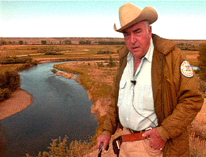
Dr. Luna Leopold discusses the importance of bankfull discharge on the New Fork River near Boulder, Wyoming. Photo courtesy of U.S. Forest Service
This paper was the keynote address to the Governor’s Conference on the California Drought, Los Angeles, California, March 7, I972
In the years around 450 B.C., that is about 2,400 years ago, the most widely travelled of the time was Herodotus. His book The Persian Wars differs from any previous written history in that he was conscious of the influences of geography, climate, and social custom in the direction of development of political and economic history of a state.
In all the intervening time, we seem not to have learned how the political and economic aspects of our lives are related to geog- raphy and climate, nor have we been able to bend social custom to accept the constraints placed on us by geography and climate. One of the obvious constraints is the finite nature of nonrenewable resources. Even those resources that are not physically destroyed by use, as oil and coal are destroyed by burning, are usually so geographically dispersed by use that they can never again be collected together in usable concentrations. This happens to many metals on which we depend.
As far as renewable resources, such as water and timber, are concerned, all are parts of operating natural systems that can be deranged with very troublesome results. The hydrologic system of precipitation, streamflow, sediment, dissolved salts, ground water and evapotranspiration is typical of a system that can be deranged. Moreover, such operating systems are subject to natural fluctuations resulting from climate and geography. These fluctuations can be lessened but not eliminated.
The management of resources cannot be carried out successfully if it is looked upon as just another facet of economics, administration, and politics. Yet the latter view describes rather accurately our present approach to resource use (it can hardly
be called management).
The view that Herodotus elaborated had little effect on the course of events between the time of Alexander’s death and the final conquest of Greece by Rome. Neither he nor any of the ad- ministrative and political leaders knew how to use a philosophic view of geography, climate, and social development to guide the direction of history. Again and again the requirements of crisis governed even long-range decisions that might better have been deferred until the crisis had passed and the decision makers could afford a more balanced or philosophic view of the future.
But crisis offers an advantage in that wide attention is attracted to the problem even if its underlying causes are perforce clouded by the immediacy of pressure. There is at least a greater possibility that diverse factions might be persuaded to look more closely at their common problems and perceive what unanimity eirists in their joint aspirations.
In suggesting here some aspects of the geographic, climatic, and sociological aspects of our resource problem, I recognize well enough that none of us knows how to put into operation a philosophy of water management, but there may be some merit in ex- amining some of the elements that might be included in such a philosophy.
In choosing three particular elements, out of many possible ones, to mention here, I have chosen one to fit each of the three classes of argument usually marshalled against their consideration. Against philosophic points of view, the contrary arguments include (1) Our technology can fix it; (2) It is politically impos- sible; and (3)It is an example of the impractical idealism of crackpot environmentalists.
First, in the construction of any engineering project, there always will remain some final increment of risk. Because it cannot be eliminated, it is necessary to know in advance how one will deal with that unusual event when it finally comes to pass. The answer to this will be: “We will build more dams and bigger ones.” In other works, our technology will fix it.
Second, in the face of obvious limitations of resources, whether renewable or nonrenewable, continued and indefinite expansion of resource use is patently impossible. Some movement toward a steady-state condition that lies within the bounds of resource availability is not only the crux of a resource management philosophy but is also the acid test of leadership. I do not consider this politically impossible. The public is learning. It may well be the best political course to pursue.
Third, there is a balance or harmony in natural systems which, dictated by the laws of physics, has gradually developed during the 4 billion years of Earth’s history. The maintenance of this balance is not only to the advantage of human organization, but should be the object of both our wonder and our admiration. The desire-to preserve this harmony must also be incorporated into any philosophy of water management, and I will call this, as did Herodotus, a reverence for rivers. If this is environmental idealism, then let it be said that I am an idealist.
On the first point, any building, every bridge we drive over, every dam that stores water, every highway culvert is designed for a chosen load considered to represent a reasonable choice between the costs of stronger building and the costs of failure. Only in the design of the spillway of a large dam is the maximum possible event used in the calculations. In the design of a stormwater sewer system on city streets, the event is usually that which may be expected on the average once in 15 or 20 years. Small earth dams built by government agencies usually use a spillway design such that failure once every 25 or 30 years is expectable. In all interstate highways where federal money is used, the design criterion for culverts is the 50-year event. When, as will surely happen sooner or later, a more extreme event occurs, it is assumed that the structure will fail or will at least not carry out its designed function.
Water-supply structures such as reservoirs are no exception. The residual risk can be reduced by building more of them and larger ones, but each increment of storage has less effect than the previous one and costs much more. The limit is reached, as on the mainstem of the Colorado River, in which if more storage is provided, the increase in evaporation cancels out any increase in the controlled yield of water.
Interestingly, the schemes ordinarily used for supplying water do not include any definite plans for handling the situation that is sure to arise sooner or later when the normal variance in hyrdologic phenomena brings about the improbably but expectable deficiency. Even the rainfall condition in 1977 is comparable in probability to that faced gladly by many people who play a game of chance such as roulette. At San Francisco, for example, the probability of a recurrence of the lowest rainfall year on record, 1958, is 270, or 2 chances out of 100. That is to say the probability of such a low rainfall occurring in any year is 1 in 50. At the same precipitation station, the lowest total in 2 successive years was in 1958-1959. In that 2-year period, 26.06 inches fell. The probability of this event is also just about 270, or 1 chance in 50. Again at that station, the lowest 3-year total was in the years 1958-1960. The probability of occurrence of such a low 3-year total is close to 170, or 1 chance in 100.
Now turning to the present year, if at the same San Francisco station (Sunset District) the rainfall in the present year reaches 10 inches, then the 3-year total on June 30 will be 44.4 inches. This total will have a probability of 370, or 1 in 33. The same kind of probability analysis can be made on any other station, groups of stations, or streamflow record. The present drought is obviously serious. It is unusual. But it is expectable on the basis of the past record. In other words, it will occur again in the future.
The difficulty we find ourselves in is not due to the fact that the present drought is impossible to imagine. It could not be predicted, but its eventual occurrence was assured. We are caught with minimal plans to deal with an event sure to occur. Whereas for earthquakes the occurrence is not susceptible to probability analysis because the causal mechanisms are not random, for cli mate the hydrologic phenomena of flood and drought may be treated statistically, and good estimates of probability are available to us. The departure from the mean value is expectable, but the particular year or years in which it will occur cannot be forecast. Such is the nature of hydrologic events.
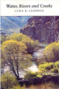
Water, Rivers and Creeks cover
In a management philosophy and plan, it is far more necessary to minimize impact of dry years than to contend with wet ones. [ed. emphasis mine] Though the risk of a deficient year is always present, seldom are definite plans on hand to cope with the situation when it finally arises. Rather, at the time of crisis there is a tendency toward grandiose plans to eliminate one further increment of risk, but a residual risk remains. The same crisis will occur again, less often but equally sure. Now is the time to lay plans for meeting an assured future event. It is not the time to plan expensive projects to reduce the risk by some small increment.
There are strategies that might help prepare for such eventualities. They will ameliorate the losses but not eliminate all hardships. However, as in all water development, they require time and advance preparation. One is as follows: There are in various parts of the western states groundwater bodies too deep to be economically developed under usual economic standards, or they have marginal water quality. These, and especially those remnants of the ice-age ground-water bodies not being recharged now, should be saved from ordinary development and reserved only for times of exceptional need. But advance engineering is needed to explore and tap them and to connect to them transmis- sion lines ready for some future contingency.
It is hardly in the public interest progressively to deplete stored but irreplaceable groundwater bodies whose greatest social use might be as unused reserve to be drawn on sporadically only when the need is grave. Such sporadic use would greatly extend the life of such irreplaceable water and would put it to a highly valued use.
In contrast, we are in several regions continuing to pump groundwater that is not being replenished. Apparently we will continue to do so as long as present conditions make its withdrawal even marginally economic. In some instances even this slim economic margin is made possible only by public subsidy through price supports.
There are many other strategies. The reuse of treated waste water is an obvious one. In this instance also, even if continued reuse on a permanent basis is uneconomic, advance preparation to reuse treated water in emergencies would be an approach to the problem of the residual risk.
Second, the occurrence of improbable but expectable deficiencies in any resource should remind us that ever-continuing growth in resource use is the antithesis of a philosophy that faces reality. In our economic climate there are few if any precedents for a fundamental re-examination of this matter and its consequences. To face this inevitable future requires the highest level of statesmanship, and crisis may provide the impetus for developing a new outlook.
The course in the past in which any and all persons may presume that they will be provided the usual resources of water, energy, and other public commodities, at any geographic location and forever in time, must eventually be abandoned. It cannot be assumed that if concentration of people continues unabated they will necessarily be supplied with those resources which at an earlier date were either nearly free or at least less expensive.
Finally, a philosophy of water management must pay heed to the fact that the hydrologic system is a highly interconnected plumbing network. Changes made in one part of the system have influences downstream. The continued functioning of the system is of great importance. To test whether the system is operating satisfactorily by economic and legal criteria alone will not guaran- tee its continued health. What is needed is some deeper feeling.
Speaking of the Persians who dominated Asia Minor in the 5th century B.C., Herodotus said, “They never defile a river with the secretions of their bodies, nor even wash their hands in one; nor will they allow others to do so, as they have a great reverence for rivers.” It is the last phrase that deserves our attention. The river is like an organism; it is internally self-adjusting. It is also resilient and can absorb changes imposed upon it, but not without limit. The limit beyond which a river cannot adjust is well illustrated by some of the effects of our national program of channelization, in which we have already dredged, straightened, channelled, revetted, trained, and “improved” more than 16,500 miles of river channels in the United States, quite apart from the thou- sands of reservoirs already built. On the drawing board of federal agencies are plans to “improve” similarly another 10,000 miles of river channels. As one minor example, the Blackwater River in Missouri was straightened and shortened 60 years ago and has since then continually and progressively lowered its bed by erosion, washing’out a succession of bridges built increasingly larger. Downstream from the improved area, flooding has increased. The river has not been able to re-establish its equilibrium.
The great geographer, William Morris Davis, viewed the river system as having a life of its own. Its youthful headwaters, he said, are steep and rugged. It rushes toward the sea, eroding bed and bank on its way. In its central part, it is mature, winding sedately through wide valleys adjusted to its duty of transporting water and sediment. Near its mouth it has reached, in its old age, a nearly level plain through which it wanders in a somewhat aimless course toward final extinction as it joins the ocean that had provided the sustaining waters through its whole life span.
Man’s engineering capabilities are nearly limitless. Our economic views are too insensitive to be the only criteria for judging the health of the river organism. What is needed is a gentler basis for perceiving the effects of our engineering capabilities. This more humble view of our relation to the hydrologic system requires a modicum of reverence for rivers.
What is old is new again.
Colorado Rivers. Credit: Geology.com
Wyoming rivers map via Geology.com
Utah Rivers map via Geology.com
New Mexico Lakes, Rivers and Water Resources via Geology.com.
Map of Nevada’s major rivers and streams via Geology.com.
Nebraska Rivers Shown on the Map: Beaver Creek, Big Blue River, Calamus River, Dismal River, Elkhorn River, Frenchman Creek, Little Blue River, Lodgepole Creek, Logan Creek, Loup River, Medicine Creek, Middle Loup River, Missouri River, Niobrara River, North Fork Big Nemaha River, North Loup River, North Platte River, Platte River, Republican River, Shell Creek, South Loup River, South Platte River, White River and Wood River. Nebraska Lakes Shown on the Map: Harlan County Lake, Hugh Butler Lake, Lake McConaughy, Lewis and Clark Lake and Merritt Reservoir. Map credit: Geology.com
The state needed an above-average snow year this winter to reverse the drought’s momentum. Forecasts for the next few months aren’t optimistic, either.
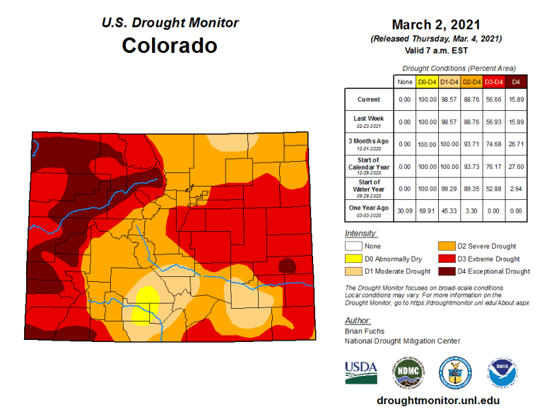
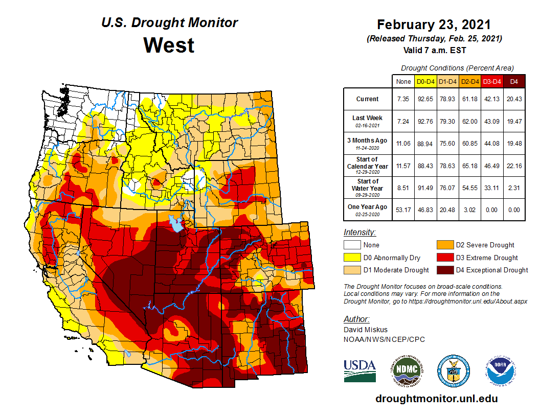
Last week’s snowstorms across the Front Range were enough to downgrade some areas from “extreme” drought to “severe,” according to the latest national drought monitor report released Thursday by the University of Nebraska. And the previous week’s map had downgraded much of the San Luis Valley from “moderate” drought to “abnormally dry.”
That’s the good news. The bad news: 98.57% of the state is still in drought, to varying degrees. And experts aren’t confident that conditions will improve anytime soon.
Colorado Drought Monitor March 2, 2021.
Unlike tornadoes, hurricanes or other weather events, drought is a phenomenon that builds over time, and its effects compound as it persists. Brian Fuchs, a climatologist with the National Drought Mitigation Center and the author of this week’s drought monitor report, noted that some regions of the state, particularly the southwest, have been drier than average for multiple years. This time last year, 45.33% of the state was in drought, none of which was classified in the worst two categories.
As of Thursday’s report, 56.66% of the state’s drought is “extreme” or “exceptional.” Colorado’s current drought conditions are the result of a combination of earlier-than-average snowmelt last spring, a lack of summer monsoons and a warm, dry autumn that led the state to use even more of its water reserves. Add this winter’s lackluster snowfall and it becomes a tricky situation.
“If it took a number of years to get into drought, what will it take over the next several years to come out of drought?” Fuchs said.
Answering that question is a complicated task. The order of operations is important, too; soils need to rehydrate first, soaking up runoff like a sponge, before the water can continue on to rivers and streams.
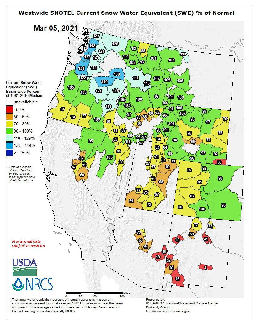
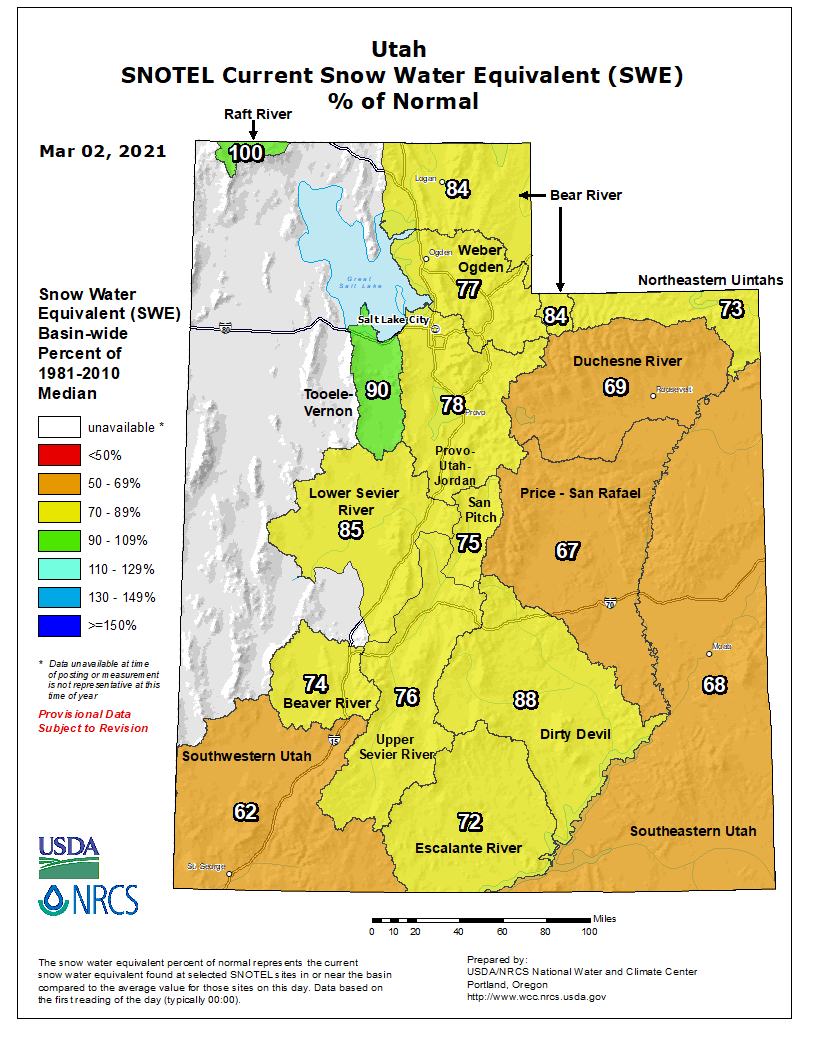
In an ideal scenario, the state would have received above-average snowpack this winter to saturate dried-out soils, store up enough moisture for better runoff this spring and summer and refill reservoirs. But snow-water equivalent estimates for Colorado’s eight alpine river basins are at least a little below their 30-year averages, according to reports from the National Resource Conservation Service…
Colorado snowpack basin-filled map March 5, 2021 via the NRCS.
The spring months are often perceived as Colorado’s snowiest time of year, but Assistant State Climatologist Becky Bolinger says that’s really only true for the Front Range. Higher elevations should be receiving sizable moisture loads all winter long, and despite recent storms, models for the next few months are not encouraging.
“Unfortunately it’s little battles that are being won in a bigger war,” Bolinger said. “One winter can be prepared for, and that’s why we have reservoirs and that’s why we monitor this. A winter like this, where we came in already struggling is definitely going to be a bigger concern.”
“We’re going to need an extended period of cooler and wetter conditions to pull us out of that and it’s not what the outlooks are showing at this point,” [Russ Schumacher] said.
Colorado is coming off a brutal fire season. More acreage was lost to wildfire in 2020 than in any other year in recorded history.
Schumacher noted that the West has been dry for most of the past 20 years, with drier years leading to catastrophic fires…
“We live in a naturally dry place,” he said. “Droughts are a big part of Colorado’s history.”
But weather patterns have not helped.
“We’ve had three summers in a row with a failed monsoon in western Colorado and also very hot conditions,” he said.
But he does not think that is a permanent shift. Climate change, he believes, is having some role and variability.
“There is some research pointing to as the climate warms, the frequency of having those wet years, it’s actually in western Colorado that might go down.”
And that’s one of the areas of the driest conditions in Colorado right now…
Snowpack, which is at 81% of average (84% of normal) is an asset to the mountains, the Front Range and even other states across the West as a water resource. Water restrictions could be coming if March and April snow does not add up and average temperatures rise.
In a move to make sure Utah’s interest in Colorado River water is protected, the Legislature…passed [H.B. 297 Substitute — Colorado River Amendments] establishing the Colorado River Authority of Utah.
Critics complained the new entity was created to push development of the Lake Powell Pipeline, but its supporters say other states in the Colorado River Basin have similar government groups to protect their allocation of what’s been described as the hardest working river in the West, supplying water to 40 million people.
In the same vein of protecting Utah’s water assets, lawmakers endorsed [H.B. 29 Substitute — Statewide Aquatic Invasive Species Emergency Response Plan] to set up a statewide invasive aquatic species emergency response plan.
The measure targets the spread of quagga mussels and supports the aggressive efforts by the Utah Department of Natural Resources and other agencies battling the invasive species, which has infected the waters of Lake Powell.
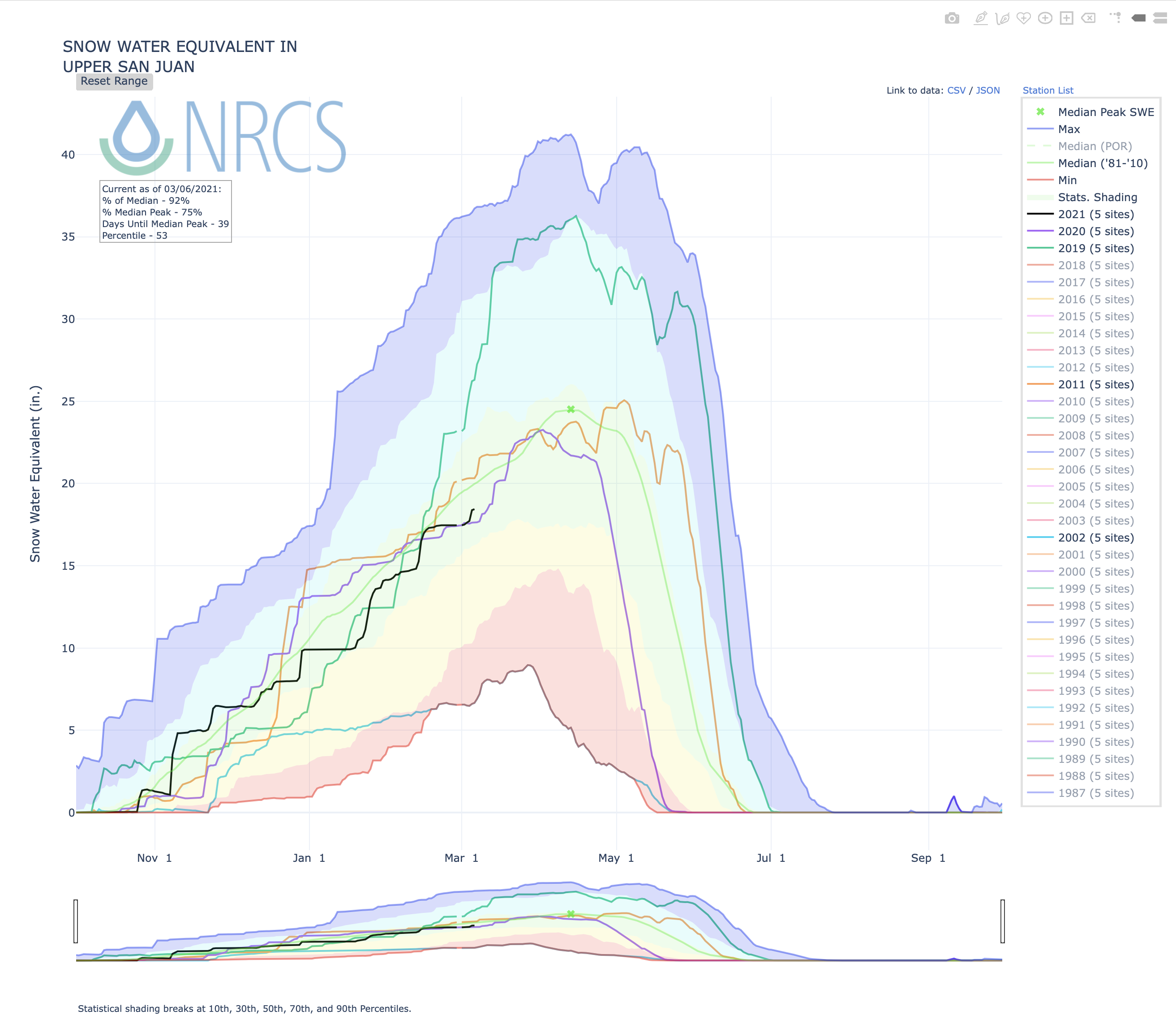
According to the U.S. Department of Agriculture National Water and Climate Center’s snowpack report, the Wolf Creek summit, at 11,000 feet of elevation, had 25.5 inches of snow water equivalent as of 2 p.m. on March 3.
That amount is 101 percent of the March 3 median for this site.
The average snow water equivalent for this date at the Wolf Creek summit is 25.8 inches.
The San Miguel, Dolores, Animas and San Juan River Basins were at 79 percent of the March 3 median in terms of snowpack. This is a 6 percent decrease in snowpack for the region compared to last week’s report.
River Report
According to the U.S. Geological Survey (USGS), the San Juan River was flowing at a rate of 59.2 cfs in Pagosa Springs as of 2 p.m. on Wednesday, March 3.
Based on 85 years of water re- cords at this site, the average flow rate for this date is 87 cfs.
The highest recorded rate for this date was in 1986 at 359 cfs. The lowest recored rate was 29.3 cfs, recorded in 2002.
An instantaneous reading was unavailable for the USGS station for the Piedra River near Arboles.
It is noted on the USGS website for this station that the reading of the river flow rate is affected by ice at the station.
Based on 58 years of water records at this site, the average flow rate for March 3 is 152 cfs.
The highest recorded rate was 573 cfs in 1995. The lowest recorded rate was 26.5 cfs in 2003.
The San Juan Water Conser- vancy District (SJWCD) approved its strategic plan for 2021 at a meeting on Feb. 15.
The strategic plan, which had been in development since 2018, is to be used to help the district identify water resource issues in the Upper San Juan River Basin within the district’s geographical scope, according to the plan.
Additionally, the plan outlines that its purpose is to help the district evaluate its options for addressing water resource issues and outlining which options could be acted upon.
Other objectives include the SJWCD Board of Directors developing long-term goals and direction for the district and relaying that information to the public, the plan notes.
Mission and value statements
Included within the plan is the SJWCD’s mission statement, which reads “To be an active leader in all issues affecting the water resources of the Upper San Juan River Basin.”
[…]
These statements note that the SJWCD board is “committed to ensuring that various current and future water supply needs are met through whatever conservation and water management strategies and methodologies are available.”
Another value statement reads, “The Board opposes any new transfers of water from the Upper San Juan River and its tributaries upstream of Navajo Reservoir to basins outside of the Upper San Juan River Basin.”
The opposition toward this comes from the SJWCD believing that transfers would interfere with existing beneficial uses of water, damage to economic stability and reduced environmental quality, the plan indicates.
Other value statements include that the SJWCD board is commit- ted to managing water rights it holds, supporting wise land-use policies and processes, and man- aging and funding effective monitoring, protection and restoration programs.
One value statement notes that the SJWCD board believes that the district must participate in statewide processes, like the Colorado Water Plan, to address various issues such as climate change, drought and water shortages.
Denver drainage carries contaminants into waterways at levels up to 137 times higher than federal safety limit
Colorado health officials this week declared water quality in the South Platte River as it flows through Denver highly deficient, pointing to E.coli contamination at levels up to 137 times higher than a federal safety limit.
This intestinal bacteria indicates fecal matter and other pollution from runoff after melting snow and rain sweeps Denver pollution through drainage pipes into the river. To deal with the problem, the Colorado Department of Public Health and the Environment has imposed, in a permit taking effect next month, stricter requirements for managing runoff water pollution.
But Denver officials are fighting those requirements and twice petitioned the state health department to relax the new permit.
“What the new requirements do is drastically increase the amount of expensive system maintenance beyond what could make a meaningful impact on E.coli concentrations,” city spokeswoman Nancy Kuhn said.
Colorado public health officials last month rejected Denver’s latest appeal. They issued a statement standing by their demands for the city to reduce its water pollution, saying the agency hopes to avoid litigation.
A more aggressive approach is required, state health officials said in the statement, “because the South Platte remains in bad shape for pathogens.”
Denver officials told The Denver Post on Wednesday “no lawsuit has been filed” challenging the permit in state court and that they are “having conversations with the state on five or so new requirements with the hope of reaching compromise.”
[…]
“Denver’s storm sewer system is a clear part of the problem,” CDPHE permitting officials said in an email. When inspectors in 2019 sampled water flowing out of city drainage “outfall” pipes into the South Platte, they detected E.coli at levels as high as 1,970 cfu from one pipe and 8,400 cfu from another, state data shows…
“Denver has never opposed the numeric limit of 126 cfu per 100 milliliters,” [Nancy Kuhn] said, but opposes “the specific measures that CDPHE is mandating to achieve that limit.”
A consultant analyzing Denver stormwater runoff in 2018 proposed, in a document included in a 419-page state fact sheet accompanying the new permit, a comprehensive effort to slow down drainage flows, treating runoff water as a useful resource for re-greening in a semi-arid area. He recommended wide use of low-cost measures such as flattening crowned streets, installing small dams in alleys to re-direct culvert-bound gushing runoff, and converting sidewalks to “semi-pervious” surfaces that let water sink between stones into the soil.
Denver’s population growth and development boom have worked against greening to improve water quality. Developers have paved over more surfaces, leaving Denver as one of the nation’s most paved-over cities — especially in newly developed areas — sluicing away runoff water at high velocity without removing contaminants.
Denver officials directed contractors at the city’s new Globeville Landing outfall drainage pipe, in a park built over a former toxic dump site, to install an ultraviolet light. This light, city officials say, zaps away more than 90% of E.coli before runoff water reaches the river.
Wild animals such as raccoons in storm sewers add to the fecal pollution contaminating runoff, Kuhn said, and “dog waste that people don’t pick up is a huge problem and a significant source of E.coli.”
Overgrown invasive trees and trash that once dominated an 18-acre parcel near Pikes Peak Avenue and South Academy Boulevard have largely been cleared away in recent weeks as Colorado Springs city crews prepare to put in new wetlands.
The lot looks more like a construction site following several weeks of work by crews who removed 200 tons of trash, but this is just a first step in a project expected to take about two years and cost several million dollars to restore the site to a more natural state. The work will slow down stormwater and help improve water quality before it flows downstream, said Richard Mulledy, Stormwater Enterprise manager.
The city will need to change the topography of the property, in part because Spring Creek and a tributary have cut deep ravines across the lot, and plant new native vegetation, including willows and cottonwoods for new wetlands, he said. The creeks themselves could see new boulders and structures to help slow the water down, he said…
In southeastern Colorado Springs, few large undevelopable properties remain, and once restored the parcel could provide a welcoming open space for the neighborhood, he said. The Stormwater Enterprise is working with the parks department on potential trail connections to the property, he said.
The wetlands could improve stormwater quality by removing nutrients from the water, such as nitrogen, that flow in from yard fertilizers and contribute to algae blooms that can kill off wildlife. Wetland plants, such as cattails and bulrushes, can also remove heavy metal particulates from the water and keep them from flowing downstream, he said…
The project is one of hundreds the city has done over the last five years to improve stormwater quality after years of not properly funding infrastructure. The neglect of the stormwater system led to the city recently agreeing to spend $45 million on projects to settle a lawsuit brought by the Environmental Protection Agency, Pueblo County and the Lower Arkansas Valley Water Conservancy District…
The Colorado Springs City Council approved an increase to monthly stormwater fees set to take effect in July to help cover the cost of those projects. Residential fees will go up from $7 per month to $8 per month over three years.
The project near Pikes Peak Avenue could see some of that funding as it takes shape in the coming years. The recent work to clean up the property and remove trees cost about $100,000 and the full restoration of wetlands could take $2 to $3 million, Mulledy said.
“What is groundwater’s value?” “If we conserve it, what is gained?” “How can cross-state cooperation help sustain rural communities in the eight-state Ogallala Aquifer region?”
These were among the many topics discussed during the Feb. 24-25 virtual Ogallala Aquifer Summit.
More than 200 people from the eight-state Ogallala Aquifer region participated in the conference via Zoom.
They included agricultural producers, commodity group representatives, federal and state agency staff, groundwater district managers and staff, and students.
With the theme, “Tackling Tough Questions,” the meeting built upon information and programs shared at the 2018 Summit in Garden City, KS.
The 2020 Summit in Amarillo was moved to 2021 due to the COVID-19 pandemic.
Some takeaway points from the keynote speakers, panels, and breakout sessions included:
Many people have the mindset that the “Ogallala Aquifer will run out of water—what will we do?” Instead, they should be thinking that the “Ogallala Aquifer will change–how do we embrace this? It is not a problem to be solved but rather a situation to be managed.”
Everyone must do their part to reduce the load on the Ogallala Aquifer. “It will take producers talking to producers. They need to share how they have reduced their groundwater use. Cutting back on water use can be done. It’s not easy—but it can be accomplished. Producers and others need to share these success stories.”
Multi-state networking among water leaders remains important. It is important to share information about conservation programs with others. As an example, the Master Irrigator Program, originated by North Plains Groundwater Conservation District in Texas, is now being implemented in other states in the Ogallala region.
Mentoring programs are essential to foster the next generation of water leaders.Technology can be overwhelming to some. It is important to showcase simple water conservation methods that can be implemented without spending a great amount of money.
Many producers said the subject of water conservation is now readily accepted at a local level. “There was a time five years ago when you would not be warmly greeted at the coffee shop if you mentioned or promoted water conservation. Things have changed since then.”
One presenter encouraged people to “have the uncomfortable conversations about water conservation. Talk candidly and freely. Dare to push the envelope without being disrespectful to others and without achieving consensus too rapidly.”
Future water conservation measures need to be proactive—rather than reactive. “Get ahead of this.”
“Many small decisions can lead to greater water savings.”
One panelist spoke to a producer about water conservation. During the conversation, the producer said his grandfather and father did not use certain water conservation practices. The younger producer made a change which saved both money and water. He admitted that conservation practices can be scary—but wished he had adopted them much sooner.
It is important to identify a common vision, practices and opportunities, for short and long-term benefits. “Do we have a consensus or a vision for the future? If we don’t know where we are going—how do we know when we get there? What is the big picture and how will your farm fit into it?”
Data is important. Don’t be afraid to collaborate. However, many are concerned that data will be used against them. “Many have said we don’t want bad data to be used against us for regulations or restrictions. Yet, they don’t want to learn that they could have irrigated an additional five years if there had been better data to support that decision. You must have a benchmark for comparison. Remember, if you are the only one in the race, then you will be the winner when you cross the finish line. You must have something for comparison purposes.”
One presenter said future Federal regulations may force banks and other lenders to take a closer look at water management on farms. “Producer A does a good job conserving water on his farm. Producer B may have little or no conservation practices in place. Because of this, lending institutions may consider Producer B to be a greater risk. It’s not just a handshake deal anymore. Use of technology and supporting data will play a larger role in lending decisions.”
There is interest in revisiting the 1982 “Six State High Plains Aquifer Study.” A comprehensive reassessment may provide new insight into the four proposed water transfer routes, feasibility of using the water for municipal and industrial purposes, aquifer storage and recovery, flood mitigation, irrigation, and an updated evaluation of water supply infrastructure.
HPWD Education and Outreach Coordinator Katherine Drury was a panelist discussing “Effective Communications and Training the Next Generation of Water Leaders.”
Funding and support for the 2021 virtual summit was provided by the Ogallala Aquifer Program; Kansas Water Office; Texas A&M AgriLife; OgallalaWater.org; USDA-NRCS; USDA-ARS National Institute of Food and Agriculture; Kansas Geological Survey; Colorado Water Center; Nebraska Water Center; Oklahoma Water Resources Center; Komet Innovative Irrigation; High Plains Water District; Kansas Center for Agricultural Resources and the Environment (KCARE); Panhandle Groundwater District; Texas Tech College of Agricultural Sciences and Natural Resources; North Platte Natural Resources District; North Plains Groundwater Conservation District; New Mexico Water Resources Institute; Texas Water Resources Institute; Water Grows; Irrigation Innovation Consortium; Zimmatic by Lindsay; and SitePro.
Additional articles with information from the 2021 Ogallala Aquifer Summit will be featured in future issues of The Cross Section.
Education and collaboration were repeatedly emphasized during the second-ever Ogallala Aquifer Summit, a virtual gathering space where hundreds of concerned farmers, researchers and resource managers shared ideas about how to preserve the vitality of a rural region that overlies one of the most heavily pumped underground reservoirs in the world.
Roughly 95 percent of all freshwater currently withdrawn from the eight-state aquifer goes to irrigate commodity crops.
Since the first aquifer summit in 2018, previous participants have expanded on several innovative programs or spread them to new areas.
The Kansas Water Office now has 15 water technology farms that demonstrate the latest irrigation technology in a real world setting.
Colorado’s Republican River Water Conservation District is putting its own spin on a Master Irrigator training program, which originated in the Texas panhandle, adding stipends and service discounts in the Burlington area to help incentivize participation, according to program coordinator Brandi Baquera.
In the Oklahoma panhandle, OSU soil and water specialist Jason Warren introduced an experiential learning program that was originally developed by the University of Nebraska. TAPS, which stands for Testing Ag Performance Solutions, uses a competitive format to engage farmers in finding new ways to optimize resources and improve input-use efficiency. The field trials help provide OSU with valuable research data, while farmers get to test out their ideas in a research simulation before making big upfront investments.
These programs, along with countless one-on-one conversations, are drawing more converts to precision water management, as the finite nature of the region’s centuries-old groundwater gradually sinks in…
Farmers are also learning to recognize the power of collecting and analyzing data, according to Billy Tiller, a Lubbock farmer and founder of Grower Information Services Cooperative, the country’s first ag-data cooperative.
For one thing, there’s immense value in simply having good data.
“As a producer, my big fear is bad data regulating me,” he said.
Then it’s often necessary to collaborate to use that data effectively, he said.
“Don’t be afraid to collaborate,” he said. “We’re always thinking about how will that data be used against me? But we have to get proactive about this.”
Tiller is currently working with the Twin Platte Natural Resources District in Nebraska on using electric smart meters to update and improve older stream-flow data previously collected by the Natural Resource Conservation Service.
He’s also building out a benchmarking tool for farmers in the district that keeps their data private, but allows them to compare themselves with other water users.
The Ogallala aquifer, also referred to as the High Plains aquifer. Source: National Oceanic and Atmospheric Adminstration
Map shows current water district boundary in red, proposed boundary in black. Blue area shows the Ogallala Aquifer. (Courtesy Republican River Water Conservation District)
Attendees at the first Ogallala Aquifer Summit, April 9 and 10, 2018, Garden City, Kansas, were broken into diversified focus groups by the organizers to better hash out issues that affect all eight states that sit above the aquifer. (Journal photo by Jennifer M. Latzke.)
Center pivot sprinklers in the Arikaree River basin to irrigate corn. Each sprinkler is supplied by deep wells drilled into the High Plains (Ogallala) aquifer.
Bar graph showing change in recoverable water in storage, 2011 to 2013 (orange) and 2013 to 2015 (green), in million acre-feet by state and in total for the High Plains aquifer. Recoverable water in storage from 2013 to 2015 for the aquifer declined 10.7 million acre-feet, which is about 30 percent of the recoverable water in storage change from 2011 to 2013. This difference is likely related to reduced groundwater pumpage during the 2013 and 2014 irrigation seasons as compared to the 2011 and 2012 irrigation seasons. (Public domain.)
Bar graph showing change in water-in-storage, predevelopment to 2015, by state and in total for the High Plains aquifer. States in region include Colorado, Kansas, Nebraska, New Mexico, Oklahoma, South Dakota, Texas and Wyoming. (Public domain.)
High Plains aquifer water-level changes, predevelopment (about 1950) to 2015. Figure 1 from USGS SIR 2017-5040.(Public domain.)
The High Plains Aquifer provides 30 percent of the water used in the nation’s irrigated agriculture. The aquifer runs under South Dakota, Wyoming, Nebraska, Colorado, Kansas, Oklahoma, New Mexico and Texas.
Here’s the release from the NRCS (Brian Domonkos):
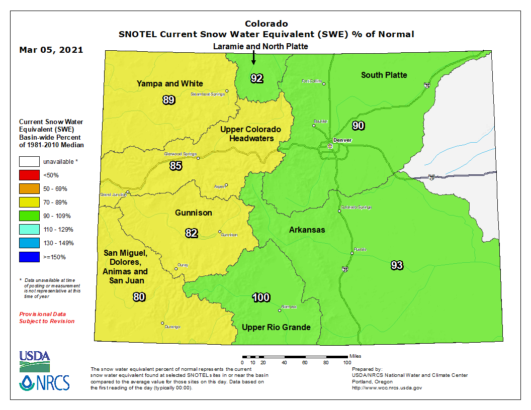
Snow accumulations during the month of February generally favored Northern Colorado. Mountain precipitation ranged from a high of 153 percent of average in the combined Yampa-White-North Platte river basin to a low of 60 percent of average in the Rio Grande. NRCS Hydrologist Karl Wetlaufer notes, “While February snow accumulations did improve the snowpack in many parts of the state, snowpack still remains below normal levels in all major basins except the Rio Grande”. Snowpack ranges from a low of 80 percent of median in the combined San Miguel-Dolores-Animas-San Juan basin to a high of 101 percent in the Rio Grande.
Map credit: NRCS
Similar to recent precipitation patterns, reservoir storage is currently more plentiful in the northern half of Colorado. Currently the only river basins in the state holding above average reservoir storage are the Colorado and combined Yampa-White river basins. On the low end, the combined San Miguel-Dolores-Animas-San Juan and the Rio Grande river basins have 60 and 67 percent of average reservoir storage, respectively.
As has been the case throughout this winter, a major consideration when it comes to spring runoff is a drought that was well in place as the snowpack began to accumulate. The summer and fall of 2020 was exceptionally warm and dry prior to the start of water year 2021. NRCS Hydrologist Wetlaufer continued to comment that “This led to dry soil moisture conditions and the expectation is that snowmelt runoff will produce lower volumes than would commonly be observed with a similar snowpack”.
The lowest streamflow forecasts in the state are coming out of the Southern San Juan Mountains and the Gunnison River Basin. The average of forecasts in these basins is for 54 and 57 percent of average volumes, respectively. The highest streamflow forecasts in the state are in the South Platte, with the average of forecasts being for 80 percent of average streamflow volumes.
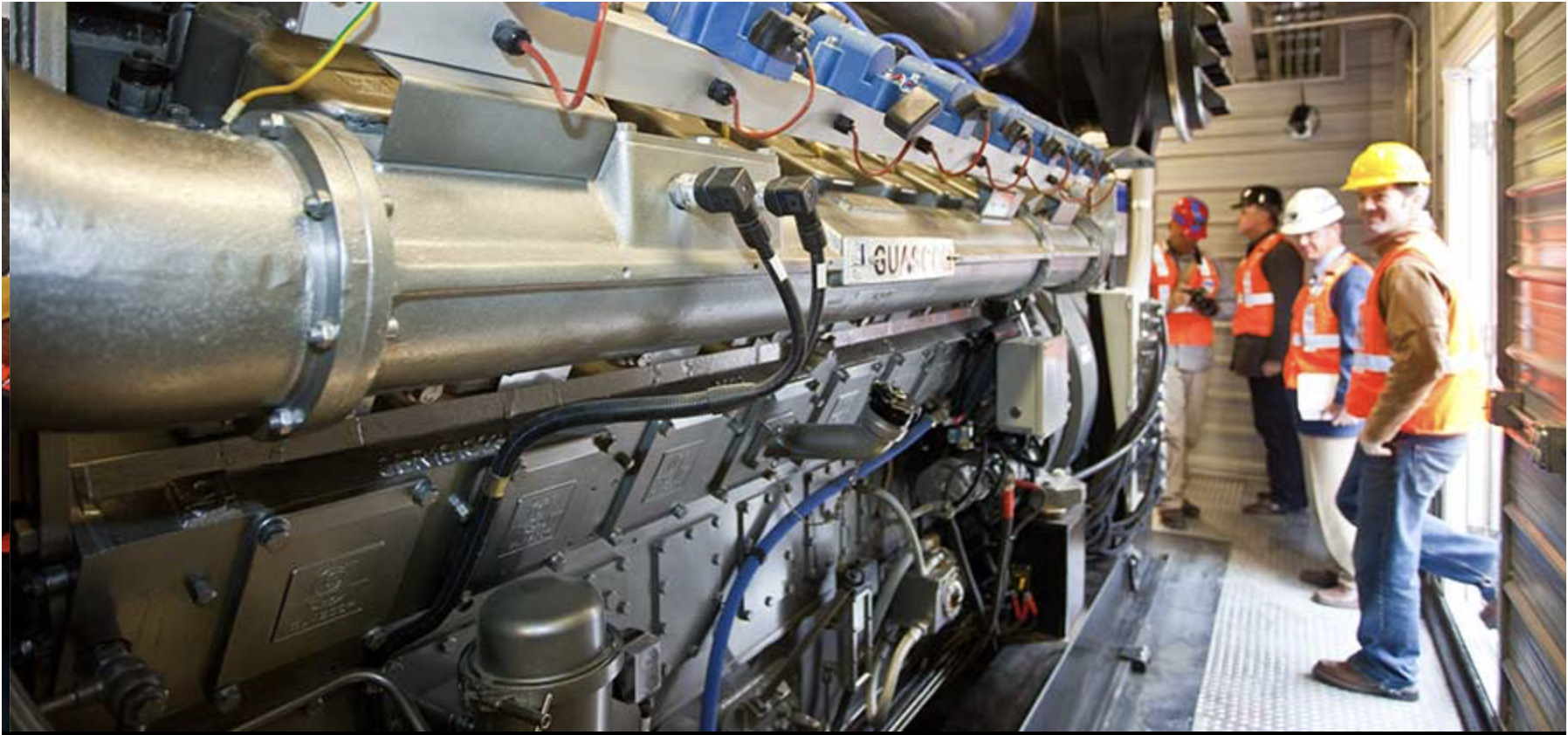
Oxbow’s Elk Creek Mine, Holy Cross Energy, and Vessels Carbon Solutions to convert waste methane from a coal plant in Somerset, Colorado into usable electricity, reducing greenhouse gas emissions and generating financial return along the way. To demonstrate the success of this project, ASC released a report telling the story of how this came about, and what the results have been. Photo credit: Aspen Skiing Company
In 2012 Aspen Skiing Company partnered with Oxbow’s Elk Creek Mine, Holy Cross Energy, and Vessels Carbon Solutions to convert waste methane from a coal plant in Somerset, Colorado into usable electricity, reducing greenhouse gas emissions and generating financial return along the way. To demonstrate the success of this project, ASC released a report telling the story of how this came about, and what the results have been. The mine produces 3 megawatts of baseload power, which is as much energy as ASC uses annually at all four of its resorts, including hotels and restaurants. The electricity generated and the carbon offsets flow into the utility grid, not to ASC directly, greening the entire regional grid. Since this project started, it has prevented the emission of 250 billion cubic feet of methane annually into the atmosphere – mitigating a huge problem when it comes to global warming. This is equivalent to removing 517,000 passenger vehicles from the road for a year. On the financial front, this methane-to-electricity project produces between $100,000 and $150,000 in revenue per month from electricity and carbon credit sales to Holy Cross Energy. After nearly ten years, ASC has only about $750,000 remaining to pay off it’s initial investment of $5.34 million.
Skico on track to recoup $5.3 million investment, provide model for climate progress
Aspen Skiing Co. says its plant that converts methane from a coal mine into electricity has proven to be an environmental and economic success since it opened in November 2012.
Skico this week released the first progress report on the plant at the Elk Creek Mine at Somerset, which is in Gunnison County on the west side of McClure Pass. The company invested $5.34 million on the clean-energy technology with an expectation of recouping the funds within 10 to 15 years. The report said Skico has only $750,000 outstanding on its initial investment after the eight full years the facility has operated.
The project generates between $100,000 to $150,000 in revenue per month from electricity and carbon credit sales to Holy Cross Energy, the report said.
The financial success is critical to getting the project replicated. Skico released the report, in part, to help stoke interest in other such efforts as part of the effort to reduce global warming. It’s an example of how a company can make a difference in solving the climate crisis, Skico officials said. The plant captures methane and converts it into electricity.
“Aspen Skiing Company’s methane project passes two tests of meaningful climate action,” the progress report said in its conclusion. “First, it’s at a large, not a token, scale. And second, it is a high profile, replicable model for others. While it is not a comprehensive market or policy solution, it illuminates a path in that direction and is an example of what one company can do to make a difference.”
Thornton Water Project route map via ThorntonWaterProject.com FromThe Loveland Reporter-Herald (Pamela Johnson):
Contractors are building 7 miles of the Thornton Pipeline in Windsor and Johnstown, including boring a 250-foot-long section under the Poudre River.
“We’re doing sections in jurisdictions where we have agreements,” said Todd Barnes, spokesman for the city of Thornton.
“We wanted to get this in the ground before their developments, so we wouldn’t have to tear up new developments. We wanted to make it as efficient and effective as possible,” he said…
That elected board, in February 2019, denied the required permit for construction of the pipeline piece north of Fort Collins.
Thornton appealed that decision in 8th Judicial District Court. Last month, a judge upheld that denial based on three land use criteria. He did rule in Thornton’s favor on an additional four land use points, but the net ruling was to uphold the decision to deny the permit.
Officials with Thornton have not said if they plan to appeal that ruling, a request that would need to be filed by April 5, or change its permit request and reapply in Larimer County…
But they have said they are committed to transporting their water to Thornton.
For the sections of the pipeline running through unincorporated Weld County, Thornton has applied for a special review permit. That is scheduled before the Weld County commissioners May 5.
And in Windsor, Johnstown and Timnath, the city worked out construction and permanent easements that allow work to be underway, Barnes said.
In early 2020, construction began in both Johnstown and Windsor, 3.5-mile-long stretches of the pipeline in each of the towns, with Scott Contracting of Centennial as the general contractor.
The Johnstown piece is nearly complete, with one major section left that involves boring a tunnel for the 42-inch-diameter pipeline below the Little Thompson River, according to information from project manager Michael Welker and Justin Schaller, construction manager with Ditesco, a company hired by Thornton for onsite construction management.
Construction is active in Windsor, running parallel to County Road 13 on the east side of the road from just north of Colo. 392 to Crossroads Boulevard.
Crews on Wednesday were actively boring and building a horizontal shaft under the Poudre River for the pipeline.
Working from a site along the Poudre River Trail, workers had bored about 85 feet of the 250-foot section that will extend under the river. They are building a support structure and placing the pipeline inside. The pipe itself is metal with a concrete lining, with 50-foot-long sections welded together.
A week ago, crews finished boring the pipeline under Colo. 392…
The overall $428 million project is expected to be completed in 2025, Barnes said, with other sections completed as Thornton receives permits.
Once the pipe is laid, crews will reclaim the land, whether it is returning vegetation, working on wildlife mitigation or preparing fields for planting or grazing.
The hot dry conditions that melted strong snowpack early in 2020 and led to severe drought, low river flows and record setting wildfires across the state could be a harbinger of what is to come in Colorado.
Climate change is likely to drive “chaotic weather” and greater extremes with hotter droughts and bigger snowstorms that will be harder to predict, said Kenneth Williams, environmental remediation and water resources program lead at Lawrence Berkeley National Laboratory, headquartered in California.
“We are looking to be moving toward a future that is really decoupled from the past,” said Williams, who is leading a long-term watershed research project in Crested Butte.
In 2020, the Colorado River system had 100% of average snowpack on April 1 but then thwarted expectations when it didn’t deliver the 90% to 110% of average runoff that water managers could typically predict. The river system only saw 52% of average runoff because water was soaked up by dry soils and evaporated during a dry, warm spring, said Brad Udall, senior water and climate research scientist at Colorado State University.
“It’s not typical, but it could very well be our future,” he said.
The 2020 drought will end at some point, but that appears unlikely this spring with the National Oceanic and Atmospheric Administration forecasting above-normal temperatures and below-normal precipitation through March, April and May.
Conditions could improve more rapidly on the eastern plains with big spring and summer rain, said Russ Schumacher, Colorado’s state climatologist.
In the larger picture, breaking the drought across the vast Colorado River Basin will likely take a string of winters with much above average snowfall, Schumacher said.
Brad Udall: Here’s the latest version of my 4-Panel plot thru Water Year (Oct-Sep) of 2019 of the #coriver big reservoirs, natural flows, precipitation, and temperature. Data goes back or 1906 (or 1935 for reservoirs.) This updates previous work with @GreatLakesPeck
In the long term, conditions across the Southwest are going to become more arid as average temperatures rise, driven by greenhouse gas emissions, Udall said, with lower soil moisture and stream flows among the negative impacts.
The 19-year stretch of only intermittingly interrupted drought from 2000 to 2018 in the Southwest U.S. was exceeded only by a late 1500s megadrought, the journal Science reported in a paper this year…
New reservoirs could play a role in the future, but construction alone cannot resolve the coming water woes.
“Anyone who thinks they can build themselves out of climate change is nuts,” Udall said. “There is a limit to the amount of storage that’s helpful.”
Too much storage can sit empty and if the water is allowed to sit for too long a valuable portion is lost to evaporation, he said.
In the highly variable years of climate-related weather to come, keeping water flowing to homes and farms will take better planning and a much better understanding of the “water towers of the West,” the remote peaks where significant amounts of snow accumulate above 8,000 feet.
Water managers are keen to know not just how much water may flow into rivers and streams, but when, and also what it might contain because as water flows drop water quality is also likely to be more of a concern…
Fort Collins weather station on the CSU campus via the Colorado Climate Center.
The rapid change has left water managers and researchers in need of better data to understand short-term trends, such as how much runoff to expect this year and longer-term shifts.
Traditionally Colorado and the West have relied on a network of more than 800 snow telemetry sites — SNOTELS, as they are called by the Natural Resources Conservation Service — that automatically collect snowpack, temperature and precipitation. But now more snow is falling at elevations above the SNOTELS and aerial observations are needed to provide an alternative source of data on snowpack utilities and others wouldn’t otherwise know about, Williams said…
A flight from NASA’s Airborne Snow Observatory gathers data about the snowpack above Dillon Reservoir on a flight. Information gathered from the flight helped Denver Water manage reservoir operations. Photo courtesy of Quantum Spatial
So Denver Water is forming a new collaborative to bring utilities, including Colorado Springs Utilities and other water users, such as water conservancy districts that serve farmers and ranchers, together to fund statewide flights, which can be quite expensive, she said.
The formal planning work around what data to collect and funding flights is set to begin in April and already the collaborative has attracted members from across the state, Kaatz said.
The group hopes to start funding the flights in about a year to provide the high quality data to water managers, Kaatz said. Having that data will be a valuable asset in Colorado’s semi-arid climate as it warms, she said.
“Warming is here and now. It’s not the next generation’s challenge.”
[…]
The rapid spring runoff is often the star in the water world. But high elevation groundwater is key to feeding streams in the late summer and winter, helping to sustain fish and late season irrigation. It is also an important source for reservoirs, said Rosemary Carroll, a hydrologist with the Desert Research Institute and collaborator on the Department of Energy projects in Crested Butte.
When Carroll started studying groundwater in the upper Gunnison watershed, she expected to find water that had percolated through the soil for two or three years before reaching streams. Instead, she’s found groundwater about a decade old, which has benefits and drawbacks during dry times, she said.
If the watershed is in a shorter drought, the groundwater can act as a buffer supplying old water that fell as snow and rain years ago, she said. But if it is a sustained drought then the absence of water from the system persists through a lack of groundwater, she said.
If the area continues to see hotter drier conditions, it’s likely that groundwater coming to the surface would be older and there will be less groundwater available to support streams, she said.
Colorado Springs Collection System via Colorado College.
As Colorado Springs Utilities braces to absorb hundreds of thousands of new residents in the coming decades amid hotter weather, it is looking to conservation, agriculture, and new water supplies from the Colorado and Arkansas rivers to help fill the gap.
Utilities examined 50 future climate scenarios to prepare its latest 50-year plan and settled on a future that will be on average 3 degrees Fahrenheit warmer with no change in average precipitation, instead of relying on historical weather trends to make projections, said Kevin Lusk, a water engineer with Utilities…
As new neighborhoods take shape, particularly in Banning Lewis Ranch, Utilities is planning for the city’s population to increase 53% from about 470,000 people to 723,000, the 50-year plan states. As those residents move in, the city’s annual water demands are expected to rise from 95,000 acre feet a year to 136,000 acre feet a year…
For Colorado Springs, reservoirs are already a key piece of a complex water system that brings 80% of the 95,000 acre feet of water the city uses annually into the area.
The largest amount of new water supply, 90,000 to 120,000 acre feet of water, is expected to come from the new or enlarged reservoirs or water storage within the Arkansas River basin, according to the 50-year plan. One of those projects could be a new reservoir or gravel pit complex between Twin Lakes and Pueblo Reservoirs, the plan states.
These wetlands in the Homestake Creek valley are near the site of the proposed Whitney Reservoir. The Forest Service is considering whether to issue a permit for drilling and a geotechnical study to test whether the site would support a dam. Photo credit: Heather Sackett/Aspen Journalism
Utilities may also build additional reservoir space in the Colorado River watershed, and it is working with Aurora on a highly controversial new reservoir in the Holy Cross Wilderness in Eagle County. The U.S. Forest Service is expected to make a decision soon on whether to permit the exploration of the new reservoir’s feasibility…
Through conservation, Utilities expects to save 10,000 to 13,000 acre feet of water annually, said Patrick Wells, general manager with Colorado Springs Utilities Water Resources and Demand Management. The city’s watering restrictions adopted last year that limit outdoor watering to three days a week from May 1 to Oct. 15 are meant to help achieve long-term water savings and more than 550 acre feet of water was saved in the first year, he said.
In the future, water owned by agricultural interests, particularly farmers and ranches in the Lower Arkansas River basin, will also play a key role. But rather than purchase it outright, Utilities is looking to lease 15,000 to 25,000 new acre feet of water annually.
The leases are a move away from purchasing farms and their associated water rights outright and transferring that water to the city, a practice called buy and dry. In the 1970s, farmers sold the water rights that previously served 45,000 acres in Crowley County leaving only 5,000 acres in production, The Gazette reported previously.
Cities bought water outright from agriculture through the early 2000s as the primary means of transfer, said Scott Lorenz, water sharing senior project manager with Colorado Springs Utilities.
Now, the state and city are focused on lease agreements that can serve farmers in dry times, he said. For example, in a dry year a farm may not have enough water to put all the fields in production, the producer can lease some water to the city and earn money through the water instead, Lorenz said.
Compensating farmers for their water and taking land out of production can have consequences, however, because it can disrupt the overall agriculture market when farmers aren’t buying seed or materials or employing laborers, said Brad Udall, senior water and climate research scientist at Colorado State University. The buyers the farms supply may also go elsewhere for products if farms aren’t producing annually, he said.
Utilities’ already has several lease agreements in place, including one in perpetuity with the Lower Arkansas Water Management Association, a group that replaces the water taken from the Arkansas River through wells. As farmers pump from ground wells supplied by the river, the association ensures water flows back into the river so that downstream residents in Kansas receive their full water rights.
The city has agreed to lease water from the association five out of every ten years and pay for its water every year, said Bill Grasmick, association president. The city also paid for a new reservoir that the association is already using.
Ephemeral streams are streams that do not always flow. They are above the groundwater reservoir and appear after precipitation in the area. Via Socratic.org
On March 2, 2021, the Tenth Circuit Court of Appeals reversed a ruling from the United States District Court for the District of Colorado in the case of Colorado v. EPA, et al., Nos. 20-1238, 20-1262, and 20-1263, that had issued a preliminary injunction blocking implementation of the Trump Administration’s Navigable Waters Protection Rule (“NWPR”) in the State of Colorado. Under the Tenth Circuit ruling, the NWPR was put back into force, and the State of Colorado’s case was remanded back to district court for further proceedings challenging the rule…
A number of lawsuits were filed challenging the NWPR, including Colorado v. EPA. The Colorado case was significant because Colorado sought, and was granted, a preliminary injunction blocking implementation of the NWPR in the State of Colorado. The State had argued that by reducing the reach of the Clean Water Act, the NWPR caused irreparable injury to the State because Colorado would be forced to undertake additional enforcement actions in place of the federal government to protect the quality of its waterways. While the district court had found this to be sufficient injury to support the State’s preliminary injunction, the Tenth Circuit found that it was too speculative and uncertain. Thus, the preliminary injunction was rejected and reversed because the State of Colorado could not show irreparable injury. Notably, the Tenth Circuit did not address the merits of the State’s challenge to the NWPR.
Additionally, prior to the Tenth Circuit’s ruling, EPA and the Army Corps of Engineers had requested the court hold the appeal in abeyance for 60 days in light of the new leadership at the agencies following the election of President Biden. The court denied the request and issued its ruling lifting the preliminary injunction the following day. The Biden Administration has indicated it is reviewing the NWPR and may want to make changes to broaden the definition of “Waters of the United States” once again. If that is the case, the agencies may look to settle the Colorado case and other similar litigation with a promise of changes to come.
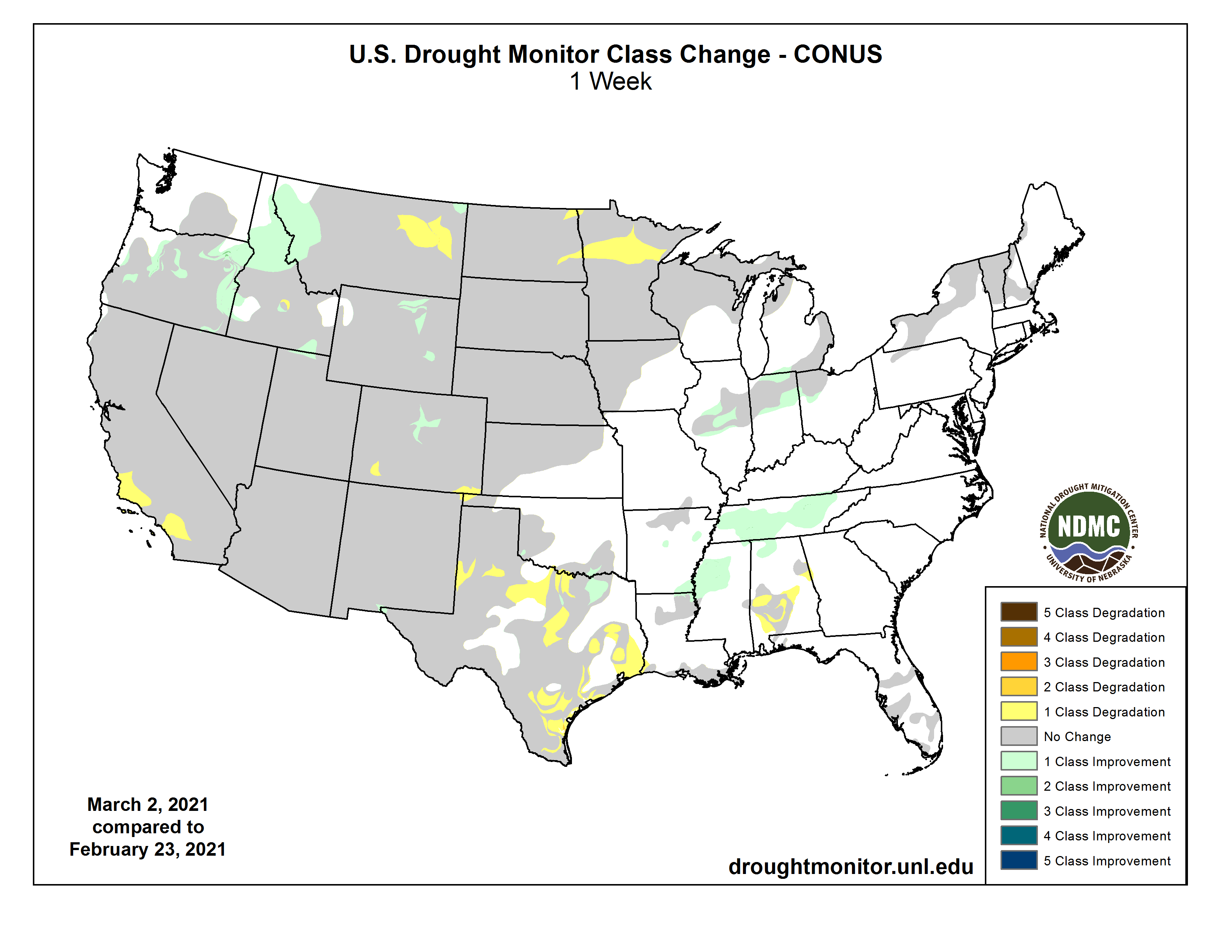
Click on a thumbnail graphic to view a gallery of drought data from the US Drought Monitor.
US Drought Monitor March 2, 2021.
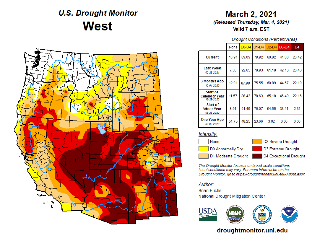
West Drought Monitor March 2, 2021.
Colorado Drought Monitor March 2, 2021.
Click here to go to the US Drought Monitor website. Here’s an excerpt:
This Week’s Drought Summary
The current U.S. Drought Monitor period was highlighted by a large swath of heavy rain that started in northeast Texas and progressed northeast into the Mid-Atlantic. In this area, widespread reports of 200-400% of normal precipitation took place, with some areas of Kentucky having widespread 6-8 inch amounts. Dry conditions dominated much of the West and especially the Southwest and into the Plains. Some active weather in the Pacific Northwest and northern Rocky Mountains brought with it rain and snow, helping to boost seasonal snow totals. Temperatures during the week were cooler than normal over the West with departures of 6-9 degrees below normal widespread, while temperatures were above normal from the Plains eastward with departures of 9-12 degrees above normal over much of Alabama…
Dry conditions dominated the region, with only portions of central South Dakota, central and eastern North Dakota, portions of the High Plains in eastern Colorado and central Wyoming recording above-normal precipitation. Temperatures were above normal over most of the area, with below-normal temperatures farther west into Wyoming and Colorado. The greatest departures were in eastern South Dakota where temperatures were 6-9 degrees above normal and northwest Wyoming where temperatures were 12-15 degrees below normal for the week. Improvements were made in north central Wyoming, where areas of extreme and severe drought were showing a good snow season to allow for a reduction in drought intensity. Severe drought was expanded in far northeast North Dakota and into far northwest Minnesota…
Dry conditions dominated areas from California to New Mexico with just a few pockets of above-normal precipitation over central Colorado, central Wyoming, the Pacific Northwest, and northern Montana. Temperatures were cooler than normal over much of the region with much of the Great Basin and into Wyoming recording temperatures 9-12 degrees below normal. After a good month of precipitation along with the most recent precipitation in the area, many areas of Oregon saw improvements to the drought status, with long-term issues still being monitored. Much of California is enduring its second consecutive dry winter, with most areas below 75% of normal snowpack for this time of year. Many water agencies were discussing water conservation measures, with the North Marin Water District considering both voluntary and mandatory water conservation orders. Moderate drought was expanded over areas of southern California where drought is beginning to develop again after a fairly dry winter. Improvements to abnormally dry, moderate and severe drought conditions were made in Idaho while abnormally dry conditions were improved over western Montana. Eastern Montana conditions continued to deteriorate with an expansion of moderate and severe drought this week. A recent winter storm in and around the Denver metro area and areas to the west allowed for improvements to the extreme drought conditions there as snow totals for the current water year were up over 100%…
There was a contrast in temperatures over the region; west Texas and Oklahoma were below normal while areas of southern Mississippi were greater than 10 degrees above normal for the week. Heavy rains fell from northeast Texas through much of southern Arkansas, northern Mississippi, and all of Tennessee this week, with areas from southern Arkansas to western Tennessee recording 400% of normal precipitation. Dry conditions dominate most of Oklahoma and the central, southern, and western portions of Texas. Improvements were made to the moderate drought over northeast Texas and southeast Oklahoma this week. A reassessment was done over southwest Oklahoma, removing the lingering extreme drought there. Exceptional drought was removed over far west Texas as the El Paso area had recorded enough precipitation recently to allow for improvement in intensity. Much of Texas saw degradations with dryness, especially over the last 4 months, dominating the indicators. Coupled with the dryness, the recent cold snap also has impacted winter wheat, with the regional agronomist stating that the drought has probably caused more loss to winter wheat across the region than the recent weather events. Early estimated losses from the recent winter storm are at least $600 million, with $230 million in damages to citrus, $228 million to livestock, and $150 million to vegetable crops in Texas. An area of extreme drought was added in the far western panhandle of Oklahoma, bridging a gap where extreme drought was being depicted in both New Mexico and Colorado…
Looking Ahead
Over the next 5-7 days, it is anticipated that precipitation totals will be greatest along the West Coast from central California into the Pacific Northwest. The Plains and Midwest as well as the Rocky Mountains may see a more active pattern, with the greatest amounts of precipitation expected over the northern Plains and Upper Midwest and portions of the central Plains. Dry conditions will dominate the Mid-Atlantic and into the Tennessee River Valley while the Florida peninsula may have several opportunities for precipitation.
The 6-10 day outlooks show the greatest chances of above-normal precipitation centered on the Midwest, with much of the country showing above-normal chances of above-normal precipitation. Coastal areas of the Southeast and into the peninsula of Florida are showing the greatest chances of below-normal precipitation. There are above-normal chances of above-normal temperatures for most areas east of the Rocky Mountains, with the greatest chances in the Midwest. Above-normal chances of below-normal temperatures are expected over much of the West, with coastal areas having the greatest chances.
Here’s the one week change map ending March 2, 2021.
US Drought Monitor one week change map ending March 2, 2021.
Just for grins here are the US Drought Monitor maps for early March for the last few years.
FromThe Washington Post (Becky Bollinger and Andrew Freedman):
Water supply and wildfire concerns grow for the dry season
According to the U.S. Drought Monitor, which has published weekly maps since 2000, the 2020 drought is the worst, in terms of its geographical scope, in more than 20 years.
Almost 80 percent of the Western U.S. is in drought, with nearly 42 percent of the region in “extreme” or “exceptional” drought.
Much of the region experienced developing drought in the summer, following a warm and dry spring. Since then, conditions have deteriorated, and the precipitation deficits continue to build. At its maximum extent in January 2021, 47 percent of the West was in extreme drought or worse. Nearly a quarter of the area was in the worst drought category, an event with a probability frequency of once every 50 to 100 years.
February did bring an active weather pattern with it. The Pacific Northwest received more than 10 inches of precipitation last month. Much of the interior Rockies through Idaho, Montana, Wyoming, Utah, and Colorado received between 1 and 5 inches of moisture for the month. The Sierra Nevada in California received between 2 and 6 inches, much of that in the form of snow.
West Drought Monitor March 2, 2021.
However, despite the precipitation, some areas are still struggling. Blue outlines in the map below show where snowpack increased last month. The Southwest was much drier in February.
Where the purple outlines overlap on this map, these areas are above average for snowpack now. Outside of the purple outlines, snowpack is still largely below average. Areas outlined in orange experienced a decline in the percentage of average snowpack since the beginning of February.
February precipitation in the West. (National Weather Service) via The Washington Post
And red outlines show the areas where snowpack is extremely low compared to normal. The evidence is clear — February was beneficial for many, but it was not a drought buster, and drought continues to maintain its stranglehold on the West…
Across the interior Rockies, snowpack usually reaches its peak in late March/early April and begins its slow melt — adding water to the rivers and eventually filling the reservoirs. While 2020 snowpack peaked around the time we’d expect, it melted out too fast, thanks to anomalously warm temperatures and no new snowstorms.
Does how it melts make a difference? You bet! Check out this water supply forecast for Lake Powell from the Colorado Basin River Forecast Center.
Water supply forecast for Lake Powell. (Colorado Basin River Forecast Center) via The Washington Post
Forecasts in the blue shading started out a bit below average (the green line is the average supply into Lake Powell). With each passing month, that forecast got a bit lower. And what actually happened was at the very low end of what was forecast (the orange line is the observed supply into Lake Powell for 2020). The actual inflow into Lake Powell was 3.4 million acre feet below average…
Fast forward to a hot and dry summer. With the exception of a couple of isolated locations in the Pacific Northwest, Idaho, and Montana, most of the West experienced much above average temperatures and below average to record low precipitation for June-September last year.
In the Southwest, July-September typically ranks as the wettest time of year, which is largely a result of the North American Monsoon. Monsoon moisture in the late summer is key for replenishing soil moisture. Without an active monsoon, soils dry out just before the beginning of snow season. And unfortunately, that happened in the fall of 2020.
Soil moisture as of Sept. 2020. (NASA) via The Washington Post
Modeled soil moisture at the end of September shows the extremely dry soils in the West. As we entered the cold season, this soil moisture was “locked in.”
The high elevation ground freezes, and that is the state the soil moisture will be at when the thaw begins in the spring. Start the season with dry soils, and that is the first “bucket” that needs to be filled when the snow starts melting.
The Colorado Basin River Forecast Center estimates that much of the Colorado River Basin needs 10 inches or more of precipitation for soil saturation. Averaged over watershed basins, normal snowpack peaks around at around 20-25 inches.
But to get the snowpack needed and cover the soil moisture deficits, these basins would potentially need 120-150 percent of average snowfall for the season. Can we expect that much snowpack this season? Unfortunately, no.
Climate change is playing a significant role in influencing water supplies in the West, with early spring snowmelt, hotter and drier summers and warming winters all acting to exacerbate drought conditions…
This map shows all the stations in the west that measure snowpack. As of Feb. 28, stations colored orange and red have below average snowpack for this time of year. The Sierra Nevadas in California are well below average for snowpack. With a typical peak date of April 1, there is only one month left to add to that snow cover. And considering they receive almost no moisture during the warm season, this month is extra critical.
Snow water equivalents compared to average. (USDA)
For the mountain ranges throughout Utah, Wyoming, and Colorado, snowpack is also below average. For the Colorado Headwaters region, there are roughly 45 days until normal peak snowpack, but the likelihood of a normal snowpack is decreasing by the day…
Becky Bolinger is the assistant state climatologist for Colorado and a research scientist at Colorado State University.
Colorado lawmakers are considering three major water bills that would help finance wildfire mitigation and forest health projects, study underground water storage for future beneficial use, and create a state enterprise to fund drinking and wastewater projects through fees paid by water utility customers.
A burnt sign on Larimer County Road 103 near Chambers Lake. The fire started in the area near Cameron Peak, which it is named after. The fire burned over 200,000 acres during its three-month run. Photo courtesy of Kate Stahla via the University of Northern Colorado
Wildfire mitigation and forest health
Last year was Colorado’s worst wildfire season ever. The three largest fires on record burned over 600,000 acres. Water providers fear that spring runoff will clog streams and reservoirs with ash and sediment, damaging clean water supplies.
House Bill 1008 is sponsored by Rep. Jeni Arndt, D-Fort Collins, and Rep. Marc Catlin, R-Montrose. (Editor’s note: Rep. Arndt is a board member of Water Education Colorado, which sponsors Fresh Water News). HB21-1008 (Forest Health Project Financing) aims to help fund local wildfire mitigation and forest health efforts to protect watersheds. It would allow counties, municipalities and special districts to band together and form special improvement districts empowered to levy property taxes to fund wildfire mitigation and forest health projects. It would also make those improvement districts eligible for $50 million from a Colorado Water Resources and Power Development Authority (CWRPDA) bond program, and expand the program’s life by 10 years to last through 2033.
Arndt said districts would be formed voluntarily and noted that any property tax assessments would require voter approval. “The Colorado way,” she said, “opt in.” Catlin, the bill’s co-sponsor, agreed. “This is an opportunity for communities to take some preemptive steps and, if needed, be able to bond through the state to get help and make the payments to take care of the problem.” Keith McLaughlin, CWRPDA executive director, emphasized that “every $1 in fire mitigation efforts saves between $3 and $6 in fire suppression costs.”
The House Agriculture, Livestock, & Water Committee passed the bill unanimously to the House Finance Committee Feb. 22. It will be heard there on March 4.
Water treatment process in Greeley. Graphic via Greeley Water
Underground water storage
Concern with declining water tables and the volume of water leaving the state in excess of compact requirements led Rep. Richard Holtorf, R-Akron, a rancher and dryland farmer, to introduce HB21-1043 Study Underground Water Storage Maximum Beneficial Use. The bill would require the Colorado Water Conservation Board (CWCB) to contract with a state university to study ways to maximize beneficial use of water by storing excess surface flows in aquifers for future use. The study would identify aquifers with storage capacity, funds to pay for storage, specific storage projects, and proposed legislation to implement its recommendations. It would be due to the interim Water Resources Review Committee by Aug. 1, 2022.
While acknowledging the value of underground water storage, some House Agriculture, Livestock, & Water Committee members questioned the need for the study since several similar studies had already been done and at least two large water providers—Denver and Greeley—are already storing water underground. There were also concerns about who would have rights to excess surface flows. Rep. Arndt, committee chair, asked, “Who would get those rights…you can’t just capture excess water?” Rep. Holtorf replied that whoever’s next in line when it reenters the river would gain use to the water; nothing changes the prior appropriation doctrine.
Rep. Holtorf concluded, “I’m not going to say it’s not complicated, but at the end of the day we’ve got to do something to get maximum beneficial use of water that we give away and try to keep it in our state for the beneficial use of everyone.” He had the backing of the Colorado Cattlemen’s Association, Colorado Farm Bureau, Colorado Water Congress and Colorado Groundwater Association. The committee passed the bill 9-1 to the House Finance Committee.
A screenshot from the website for Colorado’s Water Plan.
Financing water projects
The Colorado Water Plan, adopted in 2015, projects a need to spend an additional $100 million a year for 30 years in state money to fully fund water projects and activities to meet its objectives. Funding to date has come nowhere near that figure, but a bill introduced this session will try to put a dent in it.
SB21-034 (Water Resource Financing Enterprise), sponsored by Sen. Don Coram, R-Montrose, would create the Water Resources Financing Enterprise made up of both the CWRPDA and CWCB board of directors. The new enterprise would provide grants and loans for drinking water, wastewater treatment, and raw water delivery projects. The enterprise could issue revenue bonds to be repaid from fees assessed on drinking water customers of 25 cents per 1,000 gallons of water delivered each month in excess of the first 4,000 gallons. SB21-034 would generate roughly $37 million annually. If passed, it would go on the November 2022 ballot as a legislatively referred measure for approval by voters statewide.
The bill is similar to legislation Sen. Coram introduced last year. That bill was defeated in committee with assurances that it would be studied in greater detail by the interim Water Resources Review Committee. The pandemic, however, wiped out all interim studies. SB21-034 has been assigned to the Senate Agriculture & Natural Resources Committee and is scheduled to be heard on March 4.
Larry Morandi was formerly director of State Policy Research with the National Conference of State Legislatures in Denver, and is a frequent contributor to Fresh Water News. He can be reached at larrymorandi@comcast.net.
The All American Canal diverts water from the Lower Colorado River to irrigate crops in California’s Imperial Valley and supply 9 cities. Graphic credit: USGS
The decision of who gets to sit at that table, whose interests are represented, and what’s on the menu is still very much in flux. But the uncertainty isn’t stopping would-be participants from voicing concerns they feel leaders in the southwestern watershed can no longer ignore.
And when it comes to the water supply for 40 million people in seven U.S. states and Mexico, the stakes are much higher than a one-night feast.
“Who’s at the existing table?”
Late last year, the seven states that make up the Colorado River basin — Colorado, Wyoming, New Mexico, Utah, California, Nevada and Arizona — made clear that after a federal government-induced year-long pause to negotiations, they were ready to start negotiating future policies.
In a letter dated Dec. 17 to then-Department of the Interior Secretary David Bernhardt and Bureau of Reclamation Commissioner Brenda Burman, water officials gave notice they were “initiating preliminary conversations with one another,” to figure out how to operate the river’s biggest reservoirs.
The talks are focused on creating policy past 2026, when a current set of guidelines established in 2007 expires. The 2007 Colorado River Interim Guidelines for the first time addressed the issue of looming water shortages in the basin, and linked the operations of Lakes Powell and Mead. While those who negotiated the agreement slapped each other on the back in Las Vegas, plenty of others in the basin said it failed to truly address the wide range of problems that have plagued the watershed for decades.
When water managers negotiated that major policy overhaul in 2007, the 29 federally-recognized tribes in the watershed were left out.
From the 2018 Tribal Water Study, this graphic shows the location of the 29 federally-recognized tribes in the Colorado River Basin. Map credit: USBR
Daryl Vigil of the Jicarilla-Apache Nation says that’s also true for a landmark 2012 study that calculated water supplies and demands in the basin. According to a letter sent by 17 tribal leaders to the federal government about the 2007 guidelines, it’s only been in the last five years that tribes have seen the federal government meaningfully engage with them on Colorado River issues. Even now, as basin leaders commit to more tribal inclusivity this time around, the mechanism to do so doesn’t currently exist.
“There’s no process at all in the current structure to have inclusivity of tribes,” Vigil said.
Vigil is a co-leader of the Water & Tribes Initiative. The initiative receives funding from the Walton Family Foundation, which also supports KUNC’s Colorado River coverage. The project’s main goal is to build capacity of tribes to participate in the renegotiation of the 2007 guidelines, Vigil said.
For all the talk of consensus-building in the watershed, up until now it’s only been among a narrow group of players, Vigil said. Many other perspectives, like the river’s cultural and spiritual value or its ecological role in some of the driest reaches of the country, are ignored or rejected.
“Who’s at the existing table? The existing table in terms of policy in the Colorado River truly is controlled by the basin states and the federal government,” Vigil said…
Collectively the tribes hold rights to about 20% of the river’s flow. Combine that with a dwindling supply due to rapidly warming temperatures at the river’s headwaters, and the alarm bells start ringing more loudly…
Tribal leaders aren’t the only people who’ve been summarily excluded in the past. Environmentalists, recreation advocates, scientists and water officials from Mexico have also been left out of various agreements in the past, depending on the issue at hand.
The Grand River Diversion Dam, also known as the “Roller Dam”, was built in 1913 to divert water from the Colorado River to the Government Highline Canal, which farmers use to irrigate their lands in the Grand Valley. Photo credit: Bethany Blitz/Aspen Journalism
Xcel Energy-Colorado and other utilities propose to build 560 miles of additional 345-kilovolt transmission lines across eastern Colorado in the coming decade to get the wind and other resources they need as they close coal plants and meet expanding demand to displace fossil fuels in transportation and buildings.
The $1.7 billion investment would access 5,500 megawatts of new wind and solar power and energy storage for Xcel. Xcel is calling it Colorado’s Power Pathway.
Xcel hopes to get the first segment in service by 2025 and other segments complete in 2026 and 2027—a herculean task, given the slow pace customary to getting approval for transmission before construction actually begins.
Partnering with Xcel are Colorado’s other major electrical utilities: Tri-State Generation & Transmission, Colorado Springs Utilities, Platte River Power Authority, and Black Hills Energy. But Holy Cross Energy, another utility, will also be affected, as it relies upon Xcel’s transmission for delivery to the Aspen-Glenwood Springs-Vail areas.
“Investments in our transmission systems increase grid capacity, strengthen reliability, help us continue our clean energy transition and provide the best possible service for our customers and local communities,” said Alice Jackson, president, Xcel Energy-Colorado. “This new transmission line will support our vision to reduce carbon emissions and deliver 100% carbon-free energy by 2050 and will result in much-needed economic and generation development in the region.”
Tri-State’s participation is contingent on completion of an agreement being worked on. But the agreement in strong enough conceptually that Duane Highley, Tri-State’s chief executive, offered a statement that echoed that of Jackson, but with one small difference. The project would drive investment “in rural communities we serve,” he said. Most of the area of eastern Colorado is served by cooperatives who are members of Tri-State.
Graphic via The Mountain Town News.
In his new book, “How to Avoid Climate Disaster,” Bill Gates likens transmission to freeways and distribution lines to local roads and streets.
The plan envisions five segments that collectively sort of create a box in eastern Colorado. One leg would connect from Fort St. Vain, the gas-powered plant near Greeley, eastward to a new substation near Fort Morgan. This would roughly parallel U.S. Highway 34.
From Fort Morgan and Brush and the Pawnee power plant, which Xcel wants to convert from coal generation to natural gas by 2028, another line would continue eastward to Yuma and then veer south to Burlington and Xcel’s new wind farm at Cheyenne Ridge.
A third segment would continue south along the Kansas border to the vicinity of Lamar. From the Lamar area a fourth leg would then continue north of U.S. Highway 50 and the Arkansas River to the Tundra switching station northeast of Pueblo. The final legal would link Tundra with the Harvest Mile Substation, located southeast of Aurora.
Xcel also identifies a potential transmission line from the Lamar area south to Walsh, which may have Colorado’s very best sustained wind resource. See story, “Windy enough in Dust Bowl land.”
This is from Big Pivots, an e-magazine tracking the energy and water transitions in Colorado and beyond. Subscribe at http://bigpivots.com
The project would yield three new substations, expansion of four existing substations, including one previously planned but not yet in service.
Xcel has filed an application with the Colorado Public Utilities Commission for a certificate of public convenience and necessity. Local land-use approvals will also be required.
The release from Xcel made no mention of a major transmission bill introduced in the Colorado Legislature Sen. Chris Hansen and Rep. Alex Valdez, both Democrats from Denver.
SB21-72 seeks to enable Colorado to meet its clean energy goals by creating a new agency, the Colorado electric transmission authority, with the authority to issue revenues bonds and responsibility to identify and establish transmission corridors within Colorado and coordinate with other entities to establish transmission corridors that connected to out-of-state transmission. The bill would also allow additional classes of transmission utilities to obtain revenue through the colocation of broadband facilities within their existing rights-of-way.
It’s not clear how this bill, if made into law, will affect Xcel’s plans for transmission.
Photo shows the Brackish Groundwater National Desalination Research Facility – BGNDRF, in Alamogordo, NM via USBR
Here’s the release from the Bureau of Reclamation (Peter Soeth):
The Bureau of Reclamation is awarding $3.6 million to 10 projects for advanced water treatment research and development. The Desalination and Water Purification Research Program funding seeks to improve technologies for water supply development from nontraditional waters, including seawater, brackish groundwater, and municipal wastewater.
“Interest in desalination as a water source is growing in the United States,” said Chief Engineer David Raff. “Improving technologies to treat water will make the advanced treatment of water more affordable for communities throughout the country and increase water supplies for the nation.”
Reclamation selected six laboratory projects and four pilot-scale research projects. The $3.6 million will be matched by $5.3 million in non-federal funding to support the research projects. The selected projects are:
PILOT-SCALE PROJECTS
Carollo Engineers, Inc. (Arizona) – $403,002
Sephton Water Technology, Inc. (California) – $139,968
Gradiant Osmotics LLC (Massachusetts) – $800,000
Massachusetts Institute of Technology (Massachusetts) – $799,989
LABORATORY PROJECTS
Yale University (Connecticut) – $250,000
New Mexico Institute of Technology and Mining (New Mexico) – $249,969
University of Cincinnati (Ohio) – $249,630
SolMem, LLC (Texas) – $241,506
University of Houston (Texas) – $249,466
William Marsh Rice University (Texas) – $250,000
A laboratory-scale study involving small flow rates. They are used to determine the viability of a novel process, new materials, or process modifications. A pilot-scale project tests a novel process to determine the technical, practical, and economic viability of the process and are generally preceded by laboratory studies that demonstrate if that the technology works.
To learn more about Reclamation’s Desalination and Water Purification Research Program and see complete descriptions of the research projects, please visit http://www.usbr.gov/research/dwpr.
In part 1 of this installment of TomTalks, Nona and Hope are joined by Mike Kintgen from the Denver Botanic Gardens who teaches us about the drought in Colorado and the frequency of droughts we have experienced in history.
Stay tuned for the second part of this presentation to learn about the affects of drought and what YOU can do to help!
Screen shot from the Vimeo film, “Rio Grande Headwaters Restoration Project: Five Ditches,” https://vimeo.com/364411112
Bessemer Ditch circa 1890 via WaterArchives.org
Click here for all the inside skinny and register:
As land trusts conserve private land, they also protect water rights. Some of Colorado’s land trusts are going beyond the parcel-by-parcel approach to conservation and are tackling big water challenges in a regional way.
During this March 9 webinar, we’ll learn how land trusts work with water rights in Colorado. Then we’ll focus on two visionary projects: Colorado Open Lands and partners in the San Luis Valley are reimagining conservation easements and putting them to work to slow groundwater decline and encourage aquifer sustainability. And the Palmer Land Conservancy is protecting irrigated farmland east of Pueblo along the Bessemer Ditch with conservation easements and, thanks to a high-level landscape-scale analysis, Palmer is combatting the effects of buy and dry by keeping water on the area’s most productive ag land.
How are land trusts making these projects work? Why are they well-positioned to play such an important role in water management? Is there an opportunity for more land trusts to tackle water management challenges in these big, innovative ways? Join us to explore these questions and come prepared with your own.
With speakers:
Melissa Daruna, Keep It Colorado
Sarah Parmar, Colorado Open Lands
Ed Roberson, Palmer Land Conservancy
Presented in partnership by Water Education Colorado and Keep It Colorado
Navajo Generating Station was the largest coal-fired power plant in the American West, a testament to the political bargaining generations ago that divvied up the region’s land, minerals, and water. But the facility’s time is now up. In November 2019, the power plant stopped producing electricity. In December 2020, the trio of 775-foot smokestacks came tumbling down. Six weeks ago, the precipitators that prevented fine coal particles from being emitted into the air were dynamited, crumbling to the desert floor like felled beasts.
In the end, Navajo Generating Station will be little more than a memory. But it also leaves behind an unsettled legacy. Besides a few scattered buildings, a transmission line, and a rail line, what will remain after the facility is decommissioned is a water rights dispute.
The coal-fired power plant that sat on Navajo Nation land in the northeastern corner of Arizona did not just generate electricity. It also drew water from the Colorado River, an essential input for cooling the plant’s machinery.
What happens to that water now that the plant is being decommissioned? Who gets to decide how it is used? In a drying region in which every drop of water is accounted for and parceled out, the stakes are high and the legal claims are unresolved.
The three players are the Navajo Nation, state of Arizona, and the federal government. The ground rules are established in decades-old interstate compacts and more recent federal laws. On the horizon are unsettled water rights claims and new infrastructure. A pipeline to deliver water to the Navajo Nation in Arizona is under construction today — but due to legal complexities there is no certainty that water will immediately flow through the pipes once the system is completed.
As crews proceed with the demolition of Navajo Generating Station, water in northeastern Arizona amounts to a lingering question mark for a basin dealing with climate stress and inequality in water access for the Navajo people…
The Colorado River was part of the bargain, too. Its water, drawn from nearby Lake Powell, was needed to remove heat created during power generation. In a 1968 resolution, the Navajo Tribal Council approved the consumptive use of 34,100 acre-feet of water from the river for the facility, an agreement that was in place until the end.
Across the West, a generation of coal-fired power plants is reckoning with the same fate as Navajo Generating Station. State mandates combined with cheaper sources of electricity from sun, wind, and natural gas and expensive pollution controls are nudging the owners to retire coal-fired units.
There are benefits to this trend and not just for reducing heat-trapping gases, said Stacy Tellinghuisen of the Boulder, Colorado-based nonprofit group Western Resource Advocates. Closing these facilities brings the possibility of making water available for other industrial, municipal, agricultural, or environmental uses.
Few transfers of water rights from closed power plants have taken place because it is a complex and time-intensive process, Tellinghuisen told Circle of Blue. “Most plants have closed in the last five years,” she said. “The water rights process is slower than that.”
One place where a transfer has taken place is in Colorado. In 2013, Black Hills Energy closed the coal-fired W.N. Clark plant, located in Cañon City. In 2020, the company sold its water rights back to Cañon City Hydraulic and Irrigating Ditch Company for eventual use in irrigated agriculture…
In the case of Navajo Generating Station, water rights are where the accounting becomes tricky. The Colorado River is divided by legal compacts into upper and lower basins. The compacts allocate water between the seven states, while a treaty outlines obligations to Mexico. Most of Arizona is in the lower basin, along with California and Nevada. But not all of Arizona. A sliver of its northeastern corner is located in the upper basin. Nearly all of Arizona’s upper basin land is on the Navajo Nation.
The Upper Colorado River Compact of 1948, negotiated among the states and endorsed by Congress, provides Arizona’s upper basin with 50,000 acre-feet of Colorado River water.
The 1968 tribal council resolution states that the Navajo would not claim the water as long as Navajo Generating Station was operating. If the plant shut down, the resolution directs the Secretary of the Interior to return the water “to the Navajo Tribe for their exclusive use and benefit.”
Pollack, the water lawyer, said that the Navajo Nation’s position is that the 50,000 acre-feet in Arizona’s upper basin allocation “was intended for the benefit of the Navajo Nation.” The Nation also does not believe its water rights are circumscribed by the Upper Colorado River Compact.
How could the Navajo Nation access this water? Pollack presented two hypothetical scenarios. If the Nation, within reservation lands, wanted to dam and draw water from waterways or pump groundwater that is linked to streams, it could do so on its own, Pollack argued. Such a scenario is highly unlikely, he said, given the infrastructure that would be required to store and move water.
A more plausible scenario would be drawing water from Lake Powell, as did the power plant. That option would require a contract with the Bureau of Reclamation, which operates the reservoir. Pollack said he believes Reclamation would then consult with the state of Arizona before approving any contract.
How does the state view its role? In response to written questions, the Arizona Department of Water Resources described what it believes is the process for allocating upper basin water.
“An entity wishing to use any of Arizona’s Upper Basin allocation would need to apply to ADWR for a permit to appropriate the water,” according to the statement. “The director of ADWR would make a decision on the application based on criteria in statute, including whether the entity would put the water to a beneficial use. Water from Arizona’s Upper Basin allocation could also be allocated to an Arizona Indian tribe pursuant to a Congressionally approved Indian water rights settlement.”
There are other opinions. Mike Pearce, a partner with the Phoenix law firm Gammage & Burnham, told Circle of Blue that from his perspective the water that was used by Navajo Generating Station “would revert back to the state of Arizona to be allocated under state law.”
[…]
The water in question is not a large amount in the big picture — Arizona’s lower basin, after all, is allocated 2.8 million acre-feet from the Colorado River. But in a region that is drying as the planet warms, every drop of water is important. In the face of these hydrological changes, veteran scholars of the basin have questioned the wisdom of allowing additional withdrawals from the river. Plus, there are equity concerns. An estimated 30 percent of Navajo Nation households do not have running water, which requires them to haul water to their homes, often by driving dozens of miles roundtrip…
Some upper basin water is already being put to use in Arizona. Subtracting Navajo Generating Station, the state’s upper basin use amounted to about 11,500 acre-feet in 2018, mostly for municipal purposes in Page and debits for reservoir evaporation.
What about the rest? For now, the unused portion of Arizona’s 50,000 acre-feet is what is known colloquially as “system water.” It stays in Lake Powell and helps the upper basin meet its water delivery obligation to the lower basin.
Though currently there is not much demand in Arizona’s upper basin, there is one potential use in the near term. An act of Congress in 2009 authorized the Navajo-Gallup water supply project, a system intended to deliver water to the eastern half of the Navajo Nation, as well as the Jicarilla Apache Nation and the town of Gallup, New Mexico.
The law sets aside 22,650 acre-feet for the Navajo Nation in New Mexico, and 6,411 acre-feet for the Navajo Nation in Arizona. The water for the Arizona section is supposed to be subtracted from Arizona’s upper basin allocation.
There is a catch, though. The law states that the water can only be delivered to the Navajo Nation in Arizona if the Nation settles its water rights claims to two other Arizona basins: the Little Colorado River and the lower basin of the Colorado. The Little Colorado River adjudication is ongoing in state court.
For Pollack, the addition of that clause is an insult. It ties water access for Navajo communities in the upper basin to negotiations about other water sources…
Installing pipe along the Navajo-Gallup Water Supply Project. Photo credit: USBR
While the legal conflict simmers, the Bureau of Reclamation is continuing to build out the Navajo-Gallup supply system, a project that includes about 280 miles of pipeline in addition to two treatment plants and several pumping stations.
Patrick Page, area manager of Reclamation’s Four Corners Construction Office, wrote to Circle of Blue in an email that major components are now under construction: two pumping stations and a 30-mile section of mainline pipe.
Congress set a deadline of December 31, 2024 to complete the project. But Reclamation can extend that deadline with the agreement of the Navajo Nation and the state of New Mexico. Page said that an extension might be necessary depending on the design assessment of a key intake structure. The wait for water might grow longer.
Nick Ellis, Electrical Engineer in Statewide Monitoring Network Section, Ramesh Gautam, Chief of California Cooperative Snow Surveys Program, and Sean de Guzman, Chief of the California Department of Water Resources Snow Surveys and Water Supply Forecasting Section, conduct the second media snow survey of the 2021 season at Phillips Station in the Sierra Nevada Mountains. The survey is held approximately 90 miles east of Sacramento off Highway 50 in El Dorado County. Photo taken February 3, 2021.
Here’s a release from the California Department of Water Resources:
The Department of Water Resources (DWR) today conducted the second manual snow survey of the season at Phillips Station. The manual survey recorded 63 inches of snow depth and a snow water equivalent (SWE) of 17 inches, which is 93 percent of average for this location. The SWE measures the amount of water contained in the snowpack and is a key component of DWR’s water supply forecast.
“The recent blast of winter weather was a welcome sight, but it was not enough to offset this winter’s dry start,” said DWR Director Karla Nemeth. “While there is still a chance we will see additional storms in the coming weeks, the Department and other state agencies are preparing for the potential for a second consecutive year of dry conditions.”
Statewide snow survey measurements reflect those dry conditions. Measurements from DWR’s electronic snow survey stations indicate that statewide the snowpack’s SWE is 12.5 inches, or 70 percent of the February 3 average, and 45 percent of the April 1 average. April 1 is typically when California’s snowpack is the deepest and has the highest SWE.
Fall 2020 was extremely dry, especially in the Sierra Nevada, and follows last year’s below-average snow and precipitation. With only a couple months remaining in California’s traditional wet season, Californians should look at ways to reduce water use at home. Each individual act of conservation makes a difference over time. Visit http://SaveOurWater.com to learn easy ways to save water every day.
The winter storms that dumped heavy snow and rain across California early in 2021 are likely not enough to negate what will be a critically dry year, state water officials believe.
California’s Department of Water Resources on Tuesday recorded a snow depth of 56 inches and water content of 21 inches at Phillips Station in the Sierra Nevada. The water content of the overall snowpack was 61% of the average for March 2 and 54% of the average for April 1, when it is historically at its maximum.
Surveys of the Sierra snowpack, which normally supplies about 30% of California’s water, are a key element of the department’s water-supply forecast.
December, January and February are typically the wettest part of the “water year,” which starts Oct. 1. In January, when L.A. should have received 3.12 inches of rain, only 2.44 inches fell.
Without any serious storms on the horizon, California will end this year dry, Sean de Guzman, the department’s chief of Snow Surveys and Water Supply Forecasting, said at a Tuesday news conference.
Though Californians have made progress in embracing wise water habits, “our state’s water future remains uncertain due to the variability in precipitation and changing climate,” he said.
California’s reservoirs are beginning to see the impact of a second consecutive year with below-average precipitation across the state, de Guzman said…
Phillips Station recorded more precipitation than other locations around the state. It’s located in the central Sierra, where storm systems in January and February dumped heavy amounts of rain and snow. Stations further south have less precipitation, de Guzman said.
This year is so far similar to 2014, which came in the midst of California’s most recent severe drought, which ran from 2012 to 2016.
City of Aspen Utilities Resource Manager Steve Hunter stands at the city’s Castle Creek water diversion on Wednesday. Castle Creek is the source of most of Aspen’s potable water. CREDIT: HEATHER SACKETT/ASPEN JOURNALISM
Wildfire, infrastructure failure and persistent drought are the three biggest risks to the city of Aspen’s main water sources of Castle and Maroon creeks, according to consultants Carollo Engineers.
“The (risks) you worry about most are the ones that are fairly likely to happen and would have a pretty high consequence if they did,” said John Rehring, senior project manager and vice president of Carollo Engineers.
The risks to Aspen’s water supplies are just one of many topics consultants are taking into account as they develop a roadmap for the next 50 years of the city’s water management. As part of consultants’ data-gathering process, the city is holding the third and final community engagement session from 5 to 6:30 p.m. Wednesday.
The first two sessions were lightly attended, but city officials are hoping more citizens will show up Wednesday.
“I always like to see more people be involved,” said Steve Hunter, utilities resource manager for the city of Aspen. “We want to be completely transparent with the public.”
Carollo is working toward a final water integrated resource plan, or IRP, which they are expected to release by mid 2021. A main component of the plan will be how to address Aspen’s potential water shortages.
Although numbers are still preliminary, according to a presentation engineers gave to the city in January, the city’s estimated shortage is about 2,500 acre-feet on an annual basis. A shortage is defined as an inability to meet all demands at the same time, for example if prolonged drought cut streamflows such that the city could not provide enough water for outdoor irrigation or meet instream flow requirements.
One potential solution would be to bring online three groundwater wells in downtown Aspen, which are currently not being used because of water quality issues like too much fluoride. Having different water sources that might not be subject to natural disasters like wildfires and avalanches the same way Castle and Maroon creeks are would make Aspen’s water supply less vulnerable.
“Having the groundwater in there would help with diversity and risks and vulnerabilities,” Rehring said.
The city has a portfolio of water rights on various local waterways, ditches and wells. But it’s main source of potable water is Castle Creek.
Aspen’s Leonard Thomas Reservoir, which feeds the city’s treatment plant, holds about 10 acre-feet of water. The city is exploring other locations where it could store water as part ofthe development of a water integrated resource plan. CREDIT: HEATHER SACKETT/ASPEN JOURNALISM
Storage location
Consultants also are working on finding a location to which to move Aspen’s conditional water-storage rights and determining whether the city needs storage at all. After a lengthy water court battle, in June 2019 the city gave up its rights that could have someday allowed it to build dams and reservoirs on upper Castle or Maroon creeks.
The city has identified five other locations where it could possibly store water. Those sites are the city golf course, the Maroon Creek Club golf course, the city’s Cozy Point open space, the Woody Creek gravel pit and a 63-acre parcel of land next to the gravel pit, which the city bought in 2018.
Previous consultants have come to different conclusions about how much water storage the city actually needs. A 2017 report by Deere and Ault Consultants, which was based on conclusions in a risk analysis by Headwaters Corporation, said Aspen needs 8,500 acre-feet of water storage. But a 2016 study by Wilson Water concluded Aspen does not need any storage.
“We are trying to identify just what the storage needs are and better define just how much storage is needed or maybe how to phase in that storage capacity over time,” Rehring said. “We have not zeroed in on any particular site at this point.”
Wednesday’s meeting will take place on Zoom. To register and for more information, go to aspencommunityvoice.com.
Aspen Journalism covers water and rivers in collaboration with Swift Communications newspapers. This story ran in the March 1 edition of The Aspen Times.
From the Baca Grande Water & Sanitation District (John Loll) via The Crestone Eagle:
The Baca Grande Water and Sanitation District Board of Directors on February 17, 2021 authorized the District’s Attorney Marcus J. Lock to prepare, but not yet file, litigation against the United States Fish and Wildlife Service (USFWS) for failure to abide by a Water Service Agreement that supplies water to the Baca Grande Subdivision.
Contract negotiations deadlock
Contract negotiations over extending the current Agreement have been on-going for at least 18 months and are now stalemated. USFWS is refusing to abide by procedures stipulated in the Agreement regarding the cost of water purchased from it and would charge a rate almost ten times more than that charged for augmented water purchases in the San Luis Valley, as determined by Dick Wolfe, former State Engineer.
Relief from payment of excessive water prices is critical for the District going forward, as many components in the aging water delivery system are approaching their replacement dates. The current deadlock in negotiations is also inhibiting the District’s efforts to move forward on the purchase of water rights from USFWS. Purchase of water rights is central to the long-term health of the District and would end, as one Director said, “Throwing money down a bottomless well.”
Savings from excessive rates may help stabilize the District’s fiscal posture that has required two recent rate increases. A Lease To Own arrangement may also prove feasible, but is dependent upon being able to reach agreement on a fair rate to be charged.
The District’s Board of Directors also authorized contact with our political representatives to educate them and seek their assistance in resolving these critical issues. Educating our northern valley communities is called for as well, as they have shown in prior water battles that their determination is one of the greatest sources of advocacy available.
Background
The Baca Grande Water and Sanitation District originally leased water rights from a company called Arizona-Colorado Land & Cattle Company back in 1972. This company owned the Luis Baca Grant No. 4 and the water rights that went with it. The purpose of the lease was “to assure the availability of the water supply necessary” for the District’s operations. In 1997, the District entered into a new Water Service Agreement with Cabeza de Vaca Land & Cattle Company, LLC, which was a successor to the previous company and became the new owner of the Baca Ranch and the leased water rights. The purpose of the new Agreement remained the same, to ensure the District had access to a sufficient supply of water to serve the District’s customers.
This 1997 agreement is still in effect, but now the lessor is USFWS as a result of the federal government’s acquisition of what is now the Baca Grande National Wildlife Refuge in 2004. The Water Service Agreement is perpetual in nature unless terminated by the District. However, the District would prefer to purchase the water rights and own them outright rather than continue to make lease payments to USFWS forever.
In the Great Sand Dunes Park and Preserve Act of 2000 Congress authorized the Secretary of the Department of the Interior (which includes USFWS) to sell water rights to the District. This has yet to happen.
Maintaining positive relations with Baca National Wildlife Refuge
It’s important to make a distinction between the local USFWS representatives with whom the District has enjoyed excellent relationships throughout the years. The District very much hopes to continue with the same regard in future endeavors. Rather, the issues seem to occur in regional and national levels.
Opportunities to become involved
Soon the District will be crafting opportunities for community members to become involved in our efforts. Items under consideration include: Campaign Committee? Zoom Public Information Meetings? Postcard Campaign to elected representatives? Forming Alliances with other Local and Valley Groups?
Offer input now
You can offer your suggestions and ideas now by email to: info@bacawater.com.
Houses on the Baca Ranch tend toward environmental principles and eccentric designs. Photo/Allen Best
A Buddhist stupa is located on the Baca Ranch, about two miles from Crestone, with the Sangre de Cristo peaks in the background. Photo/Allen Best
Scenes from the Seeded and Natural Orographic Wintertime Clouds: The Idaho Experiment (SNOWIE) project, which was undertaken in Idaho’s Payette Basin in winter 2017. Credit: Joshua Aikins via Aspen Journalism
In the spring, melting snowpack in the Rocky Mountains feeds the Colorado River, which supplies drinking water to 40 million people across seven states. But as the climate warms, snowpack is shrinking, prompting concerns over water shortages.
One technique that can help increase precipitation is called cloud seeding. It’s been used in some areas since the 1950s.
A machine or airplane releases particles, such as silver iodide, into developing storm clouds. The particles attract molecules of water vapor, and if the conditions are right, those droplets form more rain or snow.
Mohammed Mahmoud is with the Central Arizona Water Conservation District, which has funded cloud seeding projects in the Rocky Mountains for years.
“The type of cloud seeding we’re interested in is winter cloud seeding, and what that does is enhance the snow pack,” he says. “So that ultimately, in the spring, that enhanced snowpack can increase the runoff that water users rely on downstream.”
The practice remains controversial, but researchers have found that cloud seeding can increase the amount of precipitation that falls in a storm by up to 15%.
So it can help reduce the impact of climate change on critical water supplies.
Colorado’s high country is just weeks away from its average peak snowpack date. Current measurements are on the fast track to coming up short.
“Our snowpack has been struggling. We’re close to average, but not quite to average so the likelihood of getting average snowpack is pretty low at this point. It’s most likely that most areas of our state will have a little bit below average snowpack when we end the season,” said Becky Bolinger, Assistant State Climatologist with the Colorado Climate Center at CSU.
Bolinger’s specialty is drought, and the state of Colorado has been keeping her busy…
With the average peak snowpack for Colorado’s northern mountains in mid-to-late April, the time to make up for the deficit is running out. Bolinger doesn’t see March and April producing enough moisture to get back to average…
Graphic via the NRCS.
Snowfall in February, while not enough to make an overall impact, did help some. Denver Water reported its collection system was at 140% of its normal accumulation for the month. While it’s not far from normal for the season at 92%, Denver Water says it could use more…
Bolinger says utility providers are constantly monitoring drought conditions and advises people pay attention to what they have to say.
“We’re going to continue in this situation where we don’t have quite enough water in the system, so another thing I’m expecting is to see, as we move into the summer, is that many of us are likely going to have some watering restrictions.”
The good news? The lack of moisture means less new growth and fewer fuels for potential fires to burn, but Bolinger is still hopeful the state sees a few strong spring storms.
“What’s keeping me up at night, very specifically, is that we go unseasonably warm, and we don’t get much more snowpack, and it melts too fast, and it melts too early, and we start our summertime temperatures too early. That means we will get into a fire season early, and then we run the risk of having another large and devastating wildfire season.”
Utah snowpack basin-filled map March 2, 2021 via the NRCS.
Last year, Utah experienced its worst drought in 20 years. Typically Utahns count on spring snowpack to remedy a dry year and while February snows have been a boon to ski areas the question remains: are they enough to generate an average water supply?
“In an average year, we’d still have about 40 more days of getting snowpack. So this storm was great. But we’re still supposed to be adding to that,” said Laura Haskell who is the senior engineer with Utah Water Resources.
She updates the U.S. Drought Monitor with Utah’s drought conditions. With 90% of the state is in extreme drought and 57% in exceptional drought, more snow is needed.
“One of the things that’s unique about this year is that yes, right now, we have 81-82% of normal snowpack for the state. But the big problem is the soil moisture, because we are in a domain that we have just not seen before,” said Jordan Clayton.
Clayton is a data collection officer with the National Resources Conservation Service, and is responsible for Utah’s snow survey. He said that even if Utah gets a normal snowpack by early April, stream runoff would still be well below average of how dry the soils are…
[Paul Miller] said based on current conditions at Lake Powell, they are likely forecasting the driest flow on record – about 60 years – in April. That forecast determines how much flow is going to be released out of Lake Powell for the rest of the water year. That impacts all of us…
Haskell noted that municipal residents may not know how current conditions impact the water supply for others, because they get water from a stored system. By being aware earlier of water conditions people can reduce their landscape water use which is one way to help.
A recent snowstorm that blew through the Mountain West was a welcome sight for states facing extreme drought. But across the southern half of the region, it may not have been as beneficial as it looks.
That’s because the storm came with a cold snap, and snow that forms in that extremely cold air doesn’t hold as much moisture…
Hendrikx said as a simple rule of thumb, every 10 inches of snow melts down to about 1 inch of water. If that snow forms in more extreme colds, though (like -20 degrees fahrenheit) it can produce half that much.
That translates to less runoff when it melts. Or rather, if it melts before it’s kicked up by the wind and faces sublimation…
Still, every bit of moisture helps in the weeks and months leading into spring. In places like Utah, Nevada, Colorado and New Mexico, the entire state is in a drought…
[Mary] Carlson said the mountains that feed the Rio Grande River have seen some good weeks recently, but they still need plenty more moisture.
This workshop is intended for staff to present to the Colorado Water Conservation Board Members what a potential framework concept for a Demand Management program could look like.
The workshop will be live streamed on YouTube for public viewing.
If you would like to make a public comment during the workshop, please complete the Request to Address the Board Form prior to the workshop.
With questions or for more information, contact Sara Leonard.
“My name is George, and I’m a recovering writer.” Credit: George Sibley via his Facebook page.
From the Upper Gunnison Water Conservancy District (Sonja Chavez) via The Gunnison Country Times:
Board loses esteemed water leader
After 14 years of service at the Upper Gunnison River Water Conservancy District, George Sibley stepped down from the district’s board earlier this month.
Sibley, 79, cited his health and age as the reasons for his decision. Upper Gunnison General Manager Sonja Chaves and Board President Michelle Piece received a letter from Sibley on Feb. 9 notifying them that his resignation was effective immediately.
“I’ve got some stress-related health issues, nothing very serious, but I’m also almost 80; it was just time to cut back on some of my involvements, and make sure I get some other personal things done I’m working on,” Sibley said Tuesday.
Chavez said Sibley and his persistence in asking difficult questions will be missed at the Upper Gunnison.
“George has so much historical and institutional knowledge of water issues on the Westerm Slope,” Chavez said. “I didn’t always agree with George, but I appreciate that he pushed those difficult conversations!’
Sibley was the Upper Gunnison’s board secretary and served on a handful of committees at the time of his resignation.
The Upper Gunnison’s Board of Directors formally thanked Sibley by passing a resolution acknowledging his service. The resolution notes Sibley’s decades of writing about water, including “Water Wranglers,” which was published in 2012 to mark the 75th anniversary of the Colorado River District, as well as his role in organizing the Colorado Water Workshop, one of the premiere meetings of water policymakers in the Western U.S.
“We will miss him dearly,” said Upper Gunnison board Vice President Stacy McPhail during the board’s meeting Tuesday.
Board member John Perusek fills Sibley’s role as secretary. The Upper Gunnison will advertise the vacancy for 45 days ahead of the Upper Gunnison’s June 28 annual meeting. Applicants will need to be residents of the City of Gunnison since Sibley represented the city’s district on the board. Applicant letters will be forwarded to Seventh Judicial District Judge Steven Patrick. In accordance with the Upper Gunnison’s founding statute, Patrick will make the appointment decision.
By summer, fields of peonies, dahlias, sunflowers, zinnias, cosmos and some 40 other varieties of flowers will shimmer in the sun and bend in the breeze.
A pergola will become a cut-flower processing center. An old tuberculosis hut will be transformed into a flower stand.
The renovated barn will host weddings and community events, the empty pig pen will be converted into bachelor’s quarters and the former chicken coop will serve as an outdoor reception area…
Children will be able to pick a Pueblo-grown pumpkin during a fall festival, with hayrides and activities planned for every Friday, Saturday and Sunday in October.
“This is one of those places that people have good memories, and that’s one of the things that’s driving my desire to be involved — for people to be in the moment and make memories again,” said Nikki McComsey, owner of Gather Mountain Blooms.
McComsey is leasing a portion of the farm and managing the property, which in the 1930s was bought by the family of the late Nick and Bambi Venetucci and now is overseen by two local philanthropic foundations.
The aged fields, where thousands of pumpkins that were given away grew plump, beans and peas could be plucked from the vine and immediately savored, and grass-fed cows, pastured pigs and productive hens roamed, have lain barren for nearly five years.
Widefield aquifer via the Colorado Water Institute.
Unforeseen contamination of the Widefield aquifer, which was saturated with perfluorinated compounds originating from firefighting foam used at Peterson Air Force Base, forced the farm to stop selling edible goods in 2016.
Revenue dried up along with the plants…
The farm’s primary source of income had been selling water from four of its seven wells to the Fountain Valley’s three water districts, said Samuel Clark, executive director of Pikes Peak Real Estate Foundation.
Water leasing netted the farm $260,000 in 2016, Clark said.
Lost revenue from produce and other consumables sold at farmers’ markets ranged from $30,000 to $190,000 annually, he said.
But the farm is poised to become bountiful once again.
After years of working with the Air Force and area water districts, Venetucci’s wells this week were connected to a new filtration system rendering water from the aquifer safe to use, according to Roy Heald, general manager of Security Water and Sanitation District.
The Grizzly Creek Fire covered 32,631 acres before it was officially deemed contained Dec. 18. It shut down Interstate 70 for two weeks after it ignited on Aug. 10. It threatened Glenwood Springs’ water supply and forced the closure of popular hiking trails and rafting put-ins.
The disruption likely isn’t finished.
“We’re going to learn a lot this summer,” said Steve Hunter, a former engineer with the White River National Forest and member of the Burn Area Emergency Response team, or BAER. That group of scientists and specialists started assessing the Grizzly Creek burn area for soil burn severity and potential problems areas for flooding and debris flows even before the fire was out.
Hunter discussed the role of the BAER team and the major issues facing the Grizzly Creek Fire burn scar during a videoconference Thursday night hosted by Roaring Fork Conservancy, a Basalt nonprofit that explores all issues related to water in the Roaring Fork Valley.
The BAER team’s work helped determined that 12% of the terrain within the perimeter of the fire suffered a high level of burn severity. That means all or nearly all of the pre-fire ground cover and surface organic matter was consumed. The soil became hardened and will shed water instead of absorb it.
Burned Area Emergency Response (BAER) specialists recently completed their data gathering and verification field work of the Grizzly Creek Fire burn area. The Soil Burn Severity map has been finalized. Soil Burn Severity levels are Unburned, Low, Moderate, and High. The map shows that in the Grizzly Creek Fire area, approximately 45% of the 32,370 acres analyzed by the BAER team is either unburned (12%) or low (33%) soil burn severity, while 43% sustained a moderate soil burn severity, and 12% burned at high soil burn severity. Map credit: Inciweb
Firefighters did a remarkable job protecting two of the major drainages from the fire. No Name Creek, which drains down into a residential area, was only 8% burned. Grizzly Creek was 14% burned. Terrain in other catchments was up to 40% burned.
The areas that suffered the most fire damage may be most susceptible to flooding, debris flows and rock falls. The Glenwood Canyon walls are steep, Hunter said.
Many of the roots and vegetation that anchored rocks and dirt have disappeared. So a canyon that was susceptible to rock falls events even before the fire is even riper now…
The Grizzly Creek Fire jumped Grizzly Creek north of Glenwood Canyon. (Provided by the City of Glenwood Springs)
Several steps have already been taken to try to gauge the risks and provide tools to warn about threats to Interstate 70, utilities in the Colorado River corridor and homes in populated parts of the canyon.
Numerous rain gauges were installed high up the canyon walls to help foresee flash flooding potential. The U.S. Geological Survey has run hydrologic modeling and runoff for major drainages within the burn area. (The website wasn’t operating properly Friday.) The U.S. Service assessed areas where culverts need to be cleared, repaired and even enlarged to handle expected debris flows…
At this point, the Forest Service does not plan to reseed significant acreage within the burn area. One hurdle is the terrain itself. Sending hand crews up the steep slopes is not practical or safe and it would be difficult to seed by airplane…
Where access isn’t as big of a challenge, the Forest Service will monitor conditions to determine if terrain can be managed for natural recovery. In other areas, such as the interstate right-of-way and at trailheads, the Forest Service is working on reseeding with the Colorado Department of Transportation…
Places where firebreaks were cut by bulldozers or hand crews, for example, need soil amendments at the least to help natural vegetation grow back. Some of those areas may also need to be seeded.
The Forest Service has also secured funding for trail and road stabilization. Some of the work started last fall and will continue when the snow melts out.

 TRAILBLAZING IN MAINE When Sandy Ritchie started as a biologist with the Maine Department of Inland Fisheries and Wildlife in the 1980s, she was one of only two women. © Abby Thrower via The Nature Conservancy
 TRAILBLAZING IN SOUTH CAROLINA Dale Threatt-Taylor is “equally effective in boots or heels” and doesn’t see any separation between being a woman and being a conservationist. © Sarah Hartman/TNC
 MAKING HER BEST CONTRIBUTION “If I don’t do the thing I’m good at, I won’t have made my best contribution,” says Samantha Horn. © Samantha Horn/TNC
 NOT JUST A CAREER, A CALLING “As more women were hired, we proved that what we may have lacked in physical strength we made up for with ingenuity and perseverance,” says Sandy Ritchie © Abby Thrower via TNC