Click on a thumbnail graphic to view a gallery of drought data from the US Drought Monitor website.
US Drought Monitor map July 13, 2021.
West Drought Monitor map July 13, 2021.
High Plains Drought Monitor map July 13, 2021.
Colorado Drought Monitor map July 13, 2021.
Click here to go to the US Drought Monitor website. Here’s an excerpt:
This Week’s Drought Summary
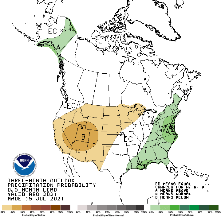
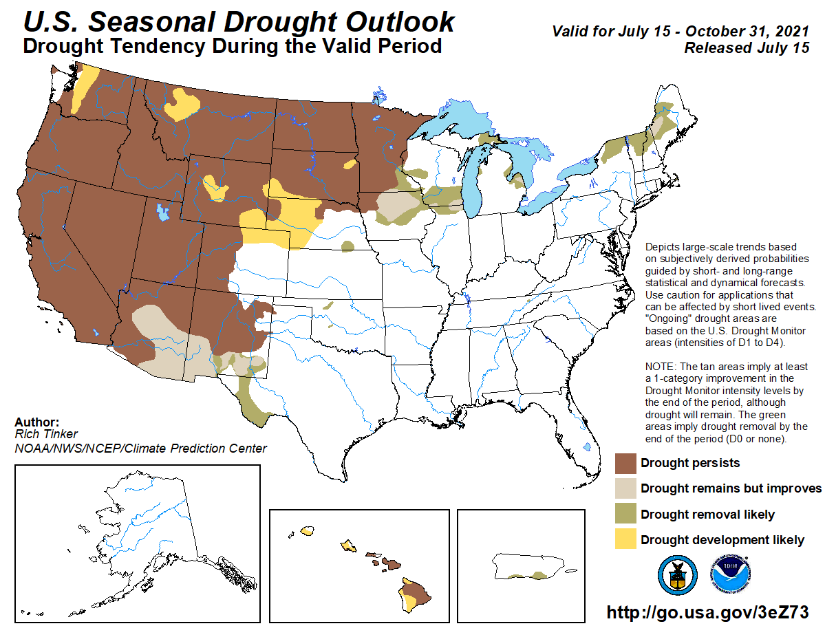
The U.S. experienced the extremes this week, with expansion of drought in the West, a robust Southwest Monsoon in the Southwest, a tropical storm making landfall in the Southeast, and extreme flooding in southeastern Texas. In the West, mid-level ridging has resulted in much above-normal temperatures for the western third of the CONUS, exacerbating drought conditions in the Pacific Northwest, northern Great Basin, Northern Rockies, and along the Front Range. Above-normal temperatures also pushed into the northern High Plains, warranting further deterioration of drought conditions in locations where rainfall remained below-average for the week. The central and eastern Corn Belt was a battle ground of sorts, with some locations seeing improvement with this week’s heavy rainfall, while other locations missed out, warranting some degradation due to antecedent dryness. New Mexico and West Texas saw targeted reductions in drought coverage due to heavy precipitation associated with the robust Southwest Monsoon. In the eastern U.S., Tropical Storm Elsa made landfall and moved up the East Coast leaving in its wake a large swath of more than 2 inches of rainfall, with several locations receiving 5 to 10 inches of rainfall. The extra-tropical transition of Elsa warranted moderate drought (D1) removal along the Virginia/North Carolina border with 1-category improvements elsewhere along Elsa’s path up the East Coast. Frontal activity prior to Elsa’s passage warranted improvements to interior areas of the Northeast. Fire risk remains high across the West…
The western half of the High Plains Region experienced above-normal average temperatures this week underneath a mid-level ridge, while the eastern half experienced below-normal average temperatures, associated with increased cloud-cover and heavy rainfall for several locations. Improvements were mainly designated to the Middle Missouri River basin, encompassing parts of eastern South Dakota and northeastern Nebraska, which received more than 2 inches of rainfall (more than 1 inch above-normal for the week). Elsewhere in the Dakotas, Nebraska, and Kansas, below-normal precipitation coupled with antecedent dryness warranted several 1-category deteriorations. In the western half of the High Plains Region, deteriorations were more a function of above-normal temperatures helping to exacerbate ongoing drought conditions in the Eastern Rockies and along the Front Range. Furthermore, this region is void of snowpack due to the below-normal rainy season in the West leading up to this period of above-normal temperatures since Spring, which has caused further depletion of soil moisture, stream flows, and ground water in many locations…
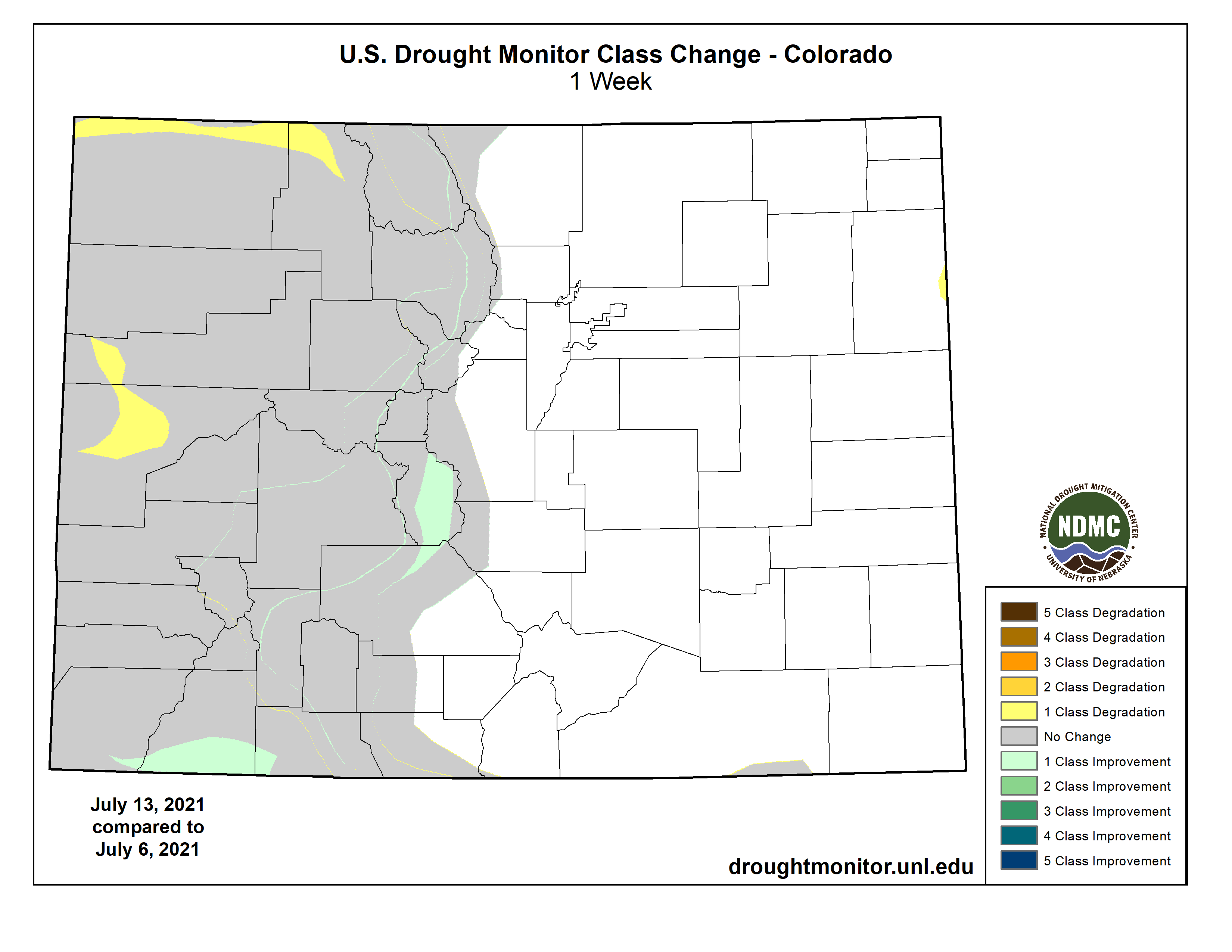
Colorado Drought Monitor one week change map ending July 13, 2021.
Extreme, record-breaking heat leading up to this week has resulted in rapid deteriorations in drought conditions across the Pacific Northwest, northern Great Basin, and Northern Rockies. Although the largest positive temperature anomalies shifted southward into the Desert Southwest and Four Corners Region this week, above-normal temperatures persisted across in the northwestern CONUS, resulting in continued degradations of drought conditions from the Pacific Northwest eastward to central Montana. A small area of improvement was warranted in northeastern Montana, where 1 to 2 inches of rainfall resulted in modest improvements to soil moisture and short-term SPIs. Farther southward in New Mexico, the robust Southwest Monsoon has resulted in drastic improvements in recent weeks. This week is more of the same, with several 1-category improvement across central and eastern portions of the state. In some cases, moisture has seeped several feet into the soils, at least down to 200 cm (per NASA SPoRT and ground reports). Improved shallow ground water conditions also support the improved depiction this week. However, fire concerns remain across the West as a whole, as there have been nearly 40 new wildfires reported since July 10 (89 as of July 14)…
A localized area of low pressure brought severe flooding to much of southeastern Texas, with many locations in and around the Houston metro area receiving 10 to 15 inches of rainfall. Some of the precipitation associated with this system made it farther westward, resulting in 1-category improvements (D0 and D1) along the Rio Grande. Western Texas, and extending into New Mexico, is experiencing improved ground conditions with this week’s rainfall, but also with antecedent conditions related to the early onset and robustness of the Southwest Monsoon, warranting 1-category improvements in the Trans-Pecos region and western parts of the Panhandle. Farther east in the Tennessee Valley, D0 coverage was reduced for many locations receiving 2 inches or more of rainfall. However, where the heavier amounts were not observed, short-term deficits continue to mount, with parts of northeastern Tennessee experiencing an expansion of abnormally dry (D0) conditions, with a small area deteriorating to moderate drought (D1) conditions, where 90-day deficits have increased to around 6 inches…
Looking Ahead
During the next 5 days (July 15 to 19), the West Coast, much of the Great Basin, and the Northern Rockies are favored to remain dry. Conversely, precipitation associated with the Southwest Monsoon is expected to continue across the Four Corners Region. In the eastern half of the U.S., a frontal boundary extending from the Central Plains to the Great Lakes is expected to move southward toward the Gulf Coast, bringing with it the potential for many areas from the Central Plains and Mississippi Valley to the East Coast to receive more than an inch of rainfall, with the highest amounts (2 inches or greater) extending from the Central Plains to the eastern Great Lakes. Maximum temperature anomalies are expected to increase across the Northern Tier (10°F to 15°F positive anomalies), while the southern half of the CONUS will experience seasonal to below-normal temperatures (less than 10°F negative anomalies).
The CPC 6-10 day extended range outlook (valid July 20 to 25) favors enhanced odds for above-normal temperatures across much of the West and Northern Tier eastward to the Great Lakes, underneath anomalous mid-level ridging. Enhanced odds for below-normal temperatures are favored across much of the Southern Tier of the CONUS and into the Northeast, associated with a weakness in the ridge in the west-central CONUS and troughing in the East. Below-normal precipitation across the Northern Tier is associated with the anomalous ridge over the western-central CONUS, with below-normal precipitation probabilities extending to the Northeast. An enhanced Southwest Monsoon favors increased precipitation chances in the Southwest and large portions of the Great Basin. Above-normal precipitation probabilities along the Gulf Coast and westward into Texas are associated with a mean frontal boundary. In Alaska, mid-level troughing over the Bering Strait increases odds for below-normal temperatures and above-normal precipitation across the Southwest and West Mainland, respectively, and eastern Aleutians. The eastern Alaska Mainland and Panhandle favor above-normal temperatures and below-normal precipitation, respectively, underneath a mean ridge.
US Drought Monitor one week change map ending July 13, 2021.
Release of firefighting foam. PFAS are substances found in firefighting foams and protective gear, as well as many household products, like pizza boxes and rain jackets. Graphic credit: ITRC
Here’s the release from the Environmental Protection Agency:
[July 12, 2021], the U.S. Environmental Protection Agency (EPA) announced Draft Contaminant Candidate List 5 (CCL 5), which provides the latest list of drinking water contaminants that are known or anticipated to occur in public water systems and are not currently subject to EPA drinking water regulations. As directed by the Safe Drinking Water Act, EPA’s CCL 5 identifies priority contaminants to consider for potential regulation to ensure that public health is protected.
“This important step will help ensure that communities across the nation have safe water by improving EPA’s understanding of contaminants in drinking water,” said EPA Assistant Administrator for Water Radhika Fox. “On PFAS, the agency is working with the scientific community to prioritize the assessment and regulatory evaluation of all chemicals as contaminants.”
The Draft CCL 5 includes 66 individual chemicals,12 microbes, and three chemical groups – per- and polyfluoroalkyl substances (PFAS), cyanotoxins, and disinfection byproducts (DBPs). These contaminants have been identified as agency priorities and contaminants of concern for drinking water. PFAS are proposed as a group, with the exception of PFOA and PFOS because the agency is moving forward with national primary drinking water standards for these two contaminants. This action is in keeping with the agency’s commitment to better understand and ultimately reduce the potential risks caused by PFAS.
CCL 5 was developed under an improved process that included new approaches to rapidly screen a significantly larger number of contaminants, prioritizing data most relevant to drinking water exposure and the potential for the greatest public health concern, and better consideration for sensitive populations and children. EPA continues to collect data and to encourage further research on the listed contaminants to better understand potential health effects from drinking water exposure before making any regulatory determinations.
EPA plans to consult with the Science Advisory Board (SAB) on the Draft CCL 5 in the fall of 2021. The agency will consider public comments and SAB feedback in developing the Final CCL 5, which is expected to be published in July 2022. After a final CCL is published, the agency will undertake a separate regulatory determination process to determine whether or not to regulate contaminants from the CCL.
Developing the CCL is the first step under the Safe Drinking Water Act (SDWA) in potentially regulating drinking water contaminants. SDWA requires EPA to publish a list of currently unregulated contaminants that are known or anticipated to occur in public water systems and that may require regulation. EPA must publish a CCL every five years. The CCL does not create or impose regulatory burden on public water systems or state, local, or Tribal governments. EPA has completed four rounds of CCLs since 1996. The last cycle of CCL, CCL 4, was published in November 2016. EPA began the development of the CCL 5 in 2018 by asking the public to nominate chemicals, microbes, or other materials for consideration for the CCL 5. The agency received 89 nominations and evaluated the nominated contaminants and other contaminant data and information in developing the Draft CCL 5.
FromThe Montrose Daily Press (Cassie Knust and Anna Lynn Winfrey):
The City of Montrose welcomed the public to roam around the nearly completed structure, which will hold 1.5 million gallons of water. In lieu of a formal presentation, city officials mingled with the crowd of curious citizens in and around the tower as the sun began its descent on July 12.
To build the water tower, Cory Noles explained that giant pieces of steel were welded together into 8-foot tall rings that were stacked on top of each other. Noles is the general superintendent of Ridgway Valley Enterprises, a commercial contractor on the project.
Despite the 135-foot height, Scott Murphy, the city engineer for Montrose and the project lead, said that the foundation is only 5 feet deep from ground level because the dirt in the area bodes well for a tall structure.
The water that is scheduled to fill the tower this November is sourced from the general city water system, which comes from the Project 7 Water Authority’s treatment plant on the east side of town.
Water towers help stabilize water pressure throughout the city. Murphy said that the tower fills up during lower demand periods, so when demand is high on hotter days, water pressure can stay constant.
The tower, which cost approximately $5 million, addresses the city’s need for water storage and prepares the city for continued growth on the western side of the Uncompahgre river.
In the case of an emergency water break, the tower can hold enough to provide the town with water for up to four days. Murphy said that only one line crosses the Uncompahgre river to the western side of town, so if a disaster struck and the pipe was obliterated, the water tower ensures that people would still have water.
The water tower is slated to sustain another period of growth in Montrose, and the city has made long-term plans to ease the construction of another tower in the future…
The project is scheduled to be completed by November of this year. Some pandemic-related shortages have caused minor delays, but the project is still slated to be completed on time…
The tower will be painted a lighter color to blend into the landscape. Murphy said that the tower will be emblazoned with the logo for the city, but artsier designs may be considered in the future.
It’s going to be difficult for legislators to strengthen Colorado’s already strong water anti-speculation laws, but that’s what a study group is looking at.
Joe Frank, manager of the Lower South Platte Water Conservancy District, told his board’s executive committee Tuesday it will be tough for the study group to come up with viable recommendations to the legislature.
The study group was authorized by Senate Bill 20-048 during the 2020 legislative session. The bill “requires the executive director of the department of natural resources to convene a work group to explore ways to strengthen current anti-speculation law and to report to the water resources review committee by August 15, 2021, regarding any recommended changes.”
Frank said the 18-member working group, which has been meeting since November 2020, is “a pretty diverse group,” and that has caused some concerns about the viability of recommendations that it may propose.
“The hard part, in my mind, is how you distinguish between traditional speculation and investment speculation, and how you protect people’s property rights,” Frank said. “How do you tell a landowner who he can and can’t sell his property to? (Some states have) laws about selling (farmland) to people outside the state, but I’ve talked to some (Colorado) tenants whose out-of-state landowners are really good landlords.”
Water speculation is generally thought of as buying water rights without having an immediate beneficial use for the water, hoping to later sell the water for a profit. The concern is that agricultural water would be taken off the land and sold out-of-state. Current water law requires that anyone buying water shares or buying ag land with a water right must have an immediate beneficial use for the water.
That has led to the practice “buy and dry,” in which cities and utilities buy agricultural land and use the water for their own purposes. One example is when Sterling purchased the Scalva Bros. farm in the early 2000s so it could use the farm’s strong water right to augment pumping for municipal use. Although the water is still being used to irrigate crops on the farm, eventually it will have to be taken off the cropland and the land returned to a natural state.
Board member Gene Manuello said anti-speculation legislation can be a double-edged sword. He referred to a 2009 Colorado Supreme Court decision in which the Pagosa Area Water and Sanitation District and San Juan Water Conservancy District were denied permission to build Dry Gulch Reservoir. Trout Unlimited sued the districts claiming their projections of water needs over the coming 50 years were excessive and amounted to water speculation.
The high court ruled that the Pagosa area water districts, which supply water to nearly all of Archuleta County, had not sufficiently demonstrated a need for the amount of water they claimed, based on projected population growth and water availability over a 50-year planning period…
A report on recommendations from the study group is due in mid-August, Frank said.
In other business Tuesday the executive committee when into executive session to discuss legal and negotiation issues concerning the proposed Fremont Butte project. That project would store excess South Platte River runoff in Prewitt Reservoir and a new reservoir south of there, to later be pumped upstream for use by the Parker Water and Sanitation District.