Once again this summer, rain has been hard to come by in this historic farming valley of southern Colorado. The average annual precipitation in the middle of the San Luis Valley hovers around seven inches — about as low as it gets in all of Colorado, according to the state’s climate center.
And yet farming prevails. It is the lifeblood of Alamosa, the town that rose from a once-bustling railroad and today is often passed by travelers en route to more flashy destinations on the Western Slope. Unlike other rural communities that have swapped mining or energy for tourism, the ruling industry here is and always has been agriculture.
“The hospital, the county and city offices and school district, all of those are important,” said Alamosa Mayor Ty Coleman. “But farming and ranching, that’s it. That’s huge.”
[…]
But by the turn of the 20th century, the Rio Grande was considered over-appropriated. Demand outpaced supply.
“So we’ve always lived in this area where there was this level of stress,” said Heather Dutton, manager of San Luis Valley Water Conservancy District and fifth-generation native.
The difference, she said, is this century’s more dire circumstances.
Fundamental changes
A multi-agency report last year found average annual streamflows to be steadily declining since the 1930s, with drops worsening in the 2000s. Citing climate change, the report warned of that long trusted snowpack in the mountains becoming less dependable.
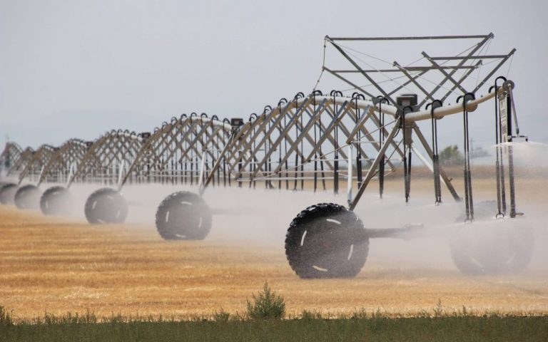
A farmer uses a center pivot to battle drought on a field in Center, Colo., in the San Luis Valley on Aug. 24, 2020. Credit: Allen Best
Where Simpson’s and Dutton’s grandfathers and fathers didn’t have the Rio Grande to count on, they had groundwater. They joined drilling and pumping that ramped up in the ’30s. The shallow and “unconfined” aquifer and deeper “confined” aquifer, both remnants of an ancient lake, represented turning points for farming.
“But it was also a turning point for what my generation is now grappling with,” Dutton said, “where now we have too many wells, we have too much pumping, and we’re taking more out of the aquifer than we’re putting back in.”
The decades saw agreements for taking and giving back — for digging a hole, filling it with water and thus recharging the unconfined aquifer in hopes of making up for Mother Nature.
“By far, that’s where most of the groundwater withdrawals occur in the valley,” Simpson said. “The potatoes are grown and raised above that unconfined aquifer. Most of the intense irrigation is above that unconfined aquifer.”
Simpson manages the Rio Grande Water Conservation District, which has tracked the aquifer’s storage since 1976. From the mid-’80s to today, charts show a staggering drop: A change amounting to about 1.3 million acre-feet of water.
The severe drought of 2002 started the steep trend of decline. Since then, there have been year-to-year gains of storage — eight years totaling 746,791 acre-feet. But there have been more years of drops, 10 totaling more than 1.7 million acre-feet. Lows this year are on par with record lows following the 2012 drought, data show.
The hope of Simpson and Dutton is to locally regulate before higher powers enforce harsher demands. The state has called on the valley to bring water back up to pre-2000 levels, or else face possible consequences of widespread shutdowns in 2030…
Farmers are taxing themselves to pump, with that money going to other farmers to pump less. Simpson and Dutton have been encouraging creativity, such as less water-needy crops like hemp and quinoa.
But they fear more drastic measures.
“There is a need to physically take land out of production,” Dutton said. “And it’s not like it’s just one person owns everything and we can just say, ‘Hey, can you cut back your farm by 30%?’ There are hundreds of families that farm and ranch here.
“And this is how they make their living, it’s in their blood, they want to do it, they’re proud of it. So trying to get people to cut back or stop farming altogether, it’s a study in psychology and human behavior. It’s really hard.”
And there are broader ramifications to consider when farms close, Simpson said. The well-being of his hometown is at stake when that happens, he said — Alamosa’s school, hospital and small businesses.
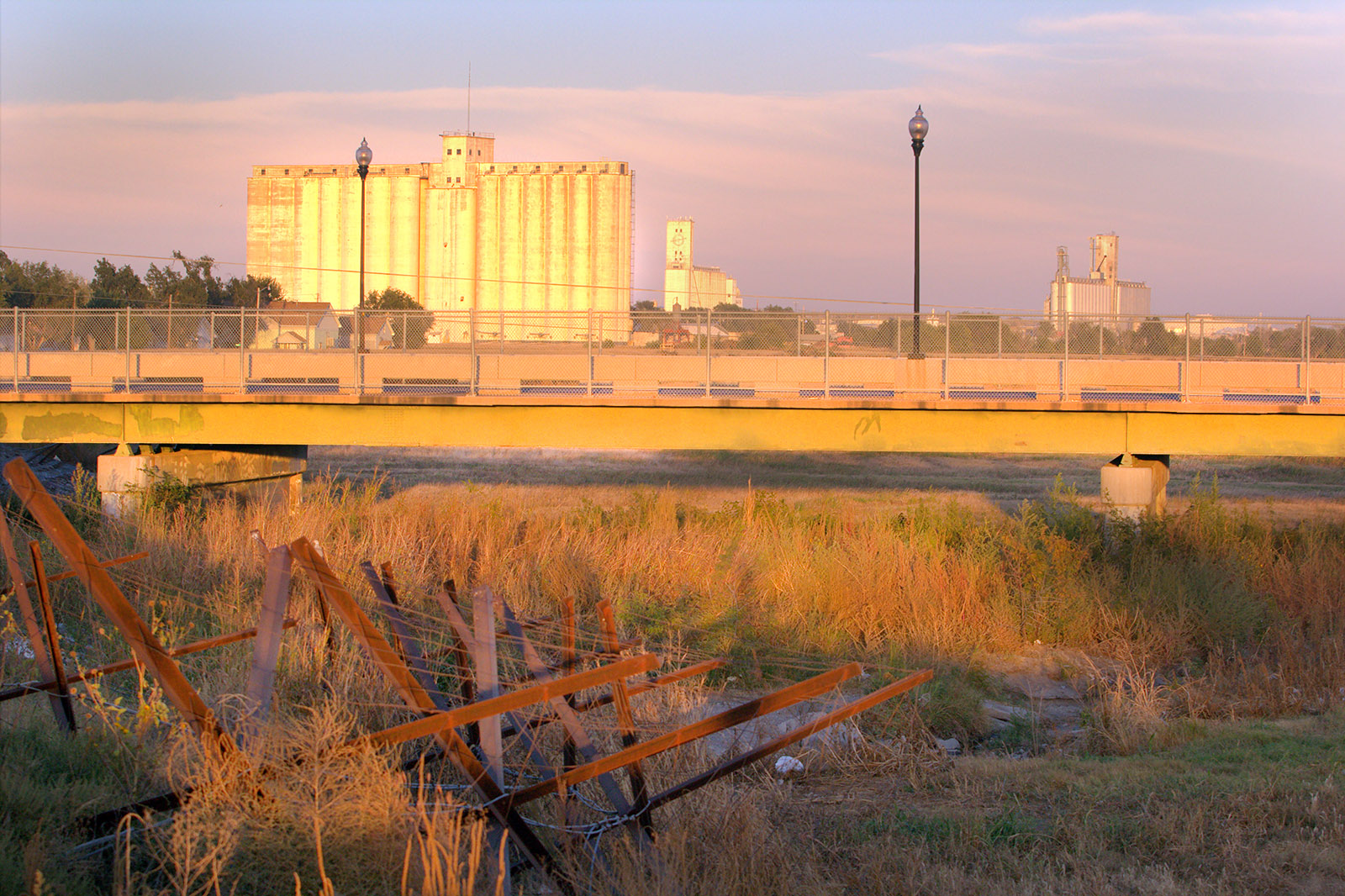
The dry bed of the Arkansas River beneath the Second Street Bridge at Dodge City, Kansas. The barricades and barbed wire are to prevent access from city property, but the river bed is public land. File Photo / Max McCoy via The Kansas Reflector
Out past the 100th meridian things get dry damned quick.
The meridian traditionally marks the line where the west begins and agriculture is difficult without irrigation. You can find it easily on a map of Kansas. Just look for Dodge City, in the lower western third of the state. The meridian runs right through town. There’s a marker at the old railway depot, but the line is really a few blocks to the east. An Eagle Scout named Michael Snapp determined the location, with the help of GPS, and in 2007 planted a 600-pound limestone post to mark the spot. It’s on the south side of Highway 50, between avenues L and M.
The Arkansas River also runs through Dodge City. Or at least it used to. It’s been a dry bed now for decades. If you (carefully!) make your way past the wire and barricades at Wright Park you can see what has become of it. The river is nothing but hard-pack sand and tire tracks, from the four-wheelers that tear up and down the old channel. The Arkansas is one of three legally navigable rivers in the state (the other are the Kaw and the Missouri), but you’d have a hard time getting a boat down it now. It’s a legal absurdity that sums up our state’s complicated relationship to water.
I wrote about this in my book, “Elevations: A Personal Exploration of the Arkansas River,” published by the University Press of Kansas. By following the Arkansas River from its headwaters at the Continental Divide above Leadville, Colorado, all the way to the Oklahoma line below Arkansas City, I learned a few things.
The most important lessons came from experts like Rex Buchanan, the former director of the Kansas Geological Survey, who for years has braved January weather to drop steel tapes down sometimes remote wells to physically measure water levels. Because of volunteers like Rex, Kansas has some of the best statistics available, and they go back decades.
I won’t pretend to speak for Rex — he’s articulate and passionate about water, and is among the state’s foremost advocates for water conservation — but I can say that water levels in the High Plains Aquifer have been going steadily down since the 1950s. The explosion of pumping technology after World War II allowed more, and deeper, water to be pumped than ever before, which was a boon to agriculture. The feeling at mid-century was that the Ogallala Aquifer — a shallow aquifer that runs for hundreds of miles below the 100th meridian, from South Dakota down to the Texas panhandle — would provide an inexhaustible supply of water. Not only does the Ogallala irrigate crops, it also provides water for industry and tap water for municipalities like Colby, along Interstate 70 in northwestern Kansas.
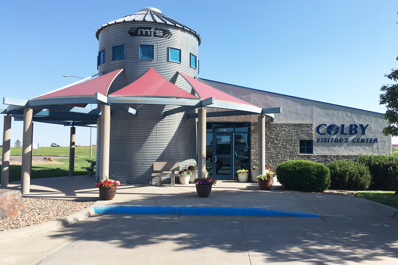
The Visitor Center at Colby, Kansas. Water is supplied to this western Kansas town from deep wells drawing from the Ogallala Aquifer. Kansas Reflector / Max McCoy via The Kansas Reflector
The problem is, the aquifer isn’t a uniform depth. Imagine an egg carton, with some deep pockets and other shallow ones, and you have some idea of the Ogallala. Because the aquifer has to be recharged by rainwater — and because things west of Dodge City are, well, arid — some places are in danger of exhausting the water supply quicker than others. Dodge City and Colby are in two of the most critically depleted parts of the aquifer of all, marked by swaths of angry red on most groundwater maps. Colby is in Thomas County, where the Kansas Geological Survey predicts the water will be depleted in less than 25 years.
I had a friend who flew into Denver recently from back east who asked me if all the circles he saw from the window seat of his airliner were some kind of crop circles or navigation aids. No, I said, that’s pivot irrigation — and it’s killing western Kansas.
Drought has hit areas like Dodge City particularly hard in recent years, because the less rain fills, the more water has to be pumped out of the ground to keep the crops growing. Some local water management districts in the state are taking conservation seriously. There are five such districts across the state, governed by local boards. And some of them — particularly toward the Nebraska line — have a chance of achieving sustainability by reducing usage by 20 or 30%. But for places like Dodge City, where demand is high and rain is slow in coming, it would take hundreds of years for the aquifer to recharge, even if all irrigation stopped today. If we drain it, some scientists say, it might take 6,000 years for it to refill naturally.
Right now, the west is experiencing a severe water crisis, with the Colorado River basin experiencing a historic, extended drought. There’s talk of the New Water Wars, with municipalities vying with farms and industries for tap water. At the same time, the heat wave of late June and early July — driven by climate change — broke records in the Pacific Northwest, with Portland hitting a jaw-dropping 116 degrees Fahrenheit.
In Kansas, we’ve so far escaped the worst of the heat wave, and an unusually wet summer has prevented drought. But we are headed into what is traditionally our hottest period, from late July to early August. The record high temperature for the state was recorded July 24, 1936, at Alton, in north central Kansas, at 121 degrees, according to the National Weather Service.
The dry bed of the Arkansas River near the Santa Fe Trail crossing at Cimarron, Kansas. The Ogallala aquifer groundwater levels in much of western Kansas started dropping in the 1950s as pumping increased, according to the Kansas Geological Survey. File Photo / Max McCoy
While researching my book about the Arkansas River, I was interested in not only the natural landscape, but also the history of how human beings have interacted with the river. What I found was disturbing. Because of irrigation and climate change, much of the river has simply dried up between Garden City and Great Bend. This has resulted in the disappearance of cottonwood trees along the riverbed, the desertification of some areas, the loss of ecosystem, and the destruction of one of the state’s most important natural features. The Arkansas is really two unconnected rivers now, the upper and the lower.
I grew up in southeast Kansas, on the edge of the Ozark Plateau. Like much of the eastern third of the state, it is a wet region, with plenty of rainfall and plenty of creeks and rivers. But out past the 100th meridian — the rainfall curtain — it’s a different and in many ways more fragile world.
Rivers of Kansas map via Geology.com
One of the things I remember most about my meeting with Buchanan, that committed soul who actually goes out and measures water levels, was a map he showed me of the historic rivers and creeks in western Kansas. The waterways looked like veins in a leaf, spreading across the high plains. Then he showed me a recent map, and many of those waterways were simply gone, erased from the landscape.
That was a few years ago. The situation has just gotten worse since.
Sign marking the 100th Meridian West at the train depot at Dodge City, Kansas. The actual meridian is a few blocks to the east. File Photo / Max McCoy
To save what is left of the water in western Kansas, we must change our relationship with water. The history of water rights in Kansas has been a troubled one. Since 1945, Kansas has been a “prior appropriation” state, like most western states, which means the right to use is based on “first in time, first in right.” It’s a property right, clear down to the aquifer. This doctrine places an emphasis on legacy water rights and prioritizes recognized “beneficial” uses, which are economic in nature.
Recognizing the hazard posed by water scarcity, Kansas since 1978 has enacted three novel legal strategies to cope with drought and dwindling resources. The first was the ability of the chief engineer — the state’s chief water administrator, at the Kansas Department of Agriculture — to designate some areas as Intensive Groundwater Use Control Areas. The second, in 1991, was to require conservation plans from some water rights applicants. The third, in 2012, gave communities within IGUCAs the authority to voluntarily create, through a public hearing process, a Local Enhanced Management Area with more restrictions. There are currently five LEMAs in the state, with Wichita County (in far western Kansas) being the newest.
But as Caleb Hall pointed out in a 2017 journal article, such efforts are insufficient to combat increased water depletion caused by climate change. Hall is an environmental attorney, a Kansas City native and a University of Kansas School of Law alum.
“IGUCAs allow established, yet still unsustainable, agricultural practices to continue,” Hall writes, “never questioning if water usage is truly beneficial if it is being applied to thirsty corn.”
If the western water rights model does not voluntarily change now, Hall argues, climate change will force it to do so in the future.
The question at the heart of the problem is what is truly beneficial.
Instead of viewing water as a property right to be exploited for personal profit, we must become guardians of that which remains. Twentieth century technology allowed us to use water at a rate far beyond what was sustainable. Climate change has brought the crisis to a head. Nothing is going to bring back the Arkansas River in western Kansas in our lifetimes, but if we start changing our laws now, we just might be able to save what’s left of the Ogallala Aquifer.
The Ogallala aquifer, also referred to as the High Plains aquifer. Source: National Oceanic and Atmospheric Adminstration
Navajo Tribal Utility Authority is asking its customers to get into the habit of conserving the water they pay for and use.
NTUA, the tribal utility enterprise that restricted the amount of water its water-loading stations could take, stated on Wednesday asking its consumers to get into the habit of conserving water.
The reasons: drought and extreme weather events…
While a few areas in the Navajo Nation received nearly an inch of rain, much of the reservation received less than half an inch of precipitation, despite some places getting a heavy downpour, according to data from the Colorado Basin River Forecast Center.
On June 27, water levels in some NTUA tanks dropped 2 feet, Kontz said, because some water-loading station customers are filling their 100- to 200-gallon water tanks repeatedly throughout the day. He said NTUA found one customer took 6,000 gallons of water in two days. The significant drop in water levels prompted the water restriction to be issued.
Kontz said the water-loading stations are connected to the main water supply that provides water to its other water customers with water piping. The over-usage by water-loading station customers caused the water pressure to homes and businesses to drop.
The restriction, Kontz said, has been helping tank levels to recover.
NTUA has approximately 39,000 customers and has 18 water-loading stations that serve an unknown number of additional customers who do not have access to a piped water system.
The tribal utility company provides water for communities along the San Juan River, from Fruitland, N.M. to Teec Nos Pos, Arizona. Those communities get water from the City of Farmington. The city issued a water shortage advisory and sent a letter to NTUA on May 27, informing them it would encourage its customers to reduce their water usage by 10%.
Chris Sypher, the community works director for the City of Farmington, said on June 7, the city uses up to 16 million gallons of water a day, and NTUA has access to up to 6 million gallons of water for its reservation customers during the summer…
NTUA manages and operates the domestic, public water systems providing water for human consumption throughout the Navajo Nation. The Navajo Nation Water Resources Department oversees livestock wells and windmills.
NTUA recommends minimizing water usage by not washing parking lots or driveways, using potable water for construction purposes, watering lawns or gardens less than three times per week, and hauling less than 500 gallons – of potable water for remote home cistern systems – per day.
NTUA also recommends homeowners check for leaky faucets, leaky toilets, turn off the water while brushing their teeth, and taking fewer or shorter showers.
The West has more hydrologic variability — more flood years and drought years per average year — than any other part of the country, Jay Lund, professor of civil and environmental engineering at the University of California, Davis, and the head of the school’s Center for Watershed Sciences told ABC News.
But a study published in Science Magazine in 2020 warned that the West is exiting an unusually wet time in its history and heading toward an unusually dry time that could last years — even centuries.
Some 42% of California’s population is now under a drought emergency — every part of the state except Southern California and the San Francisco Bay Area, California Gov. Gavin Newsom said Thursday. And if some of the most prominent reservoirs in the West are any indication, residents may be in trouble. Last month, water levels in Lake Mead, the largest reservoir in the country, hit historic lows — an alarming notion considering the West is largely dependent on surface water.
Neighboring Lake Powell, the second-largest reservoir in the U.S., is seeing similar patterns. Lake Mead and Lake Powell will likely never refill to previously normal levels, John Berggren, a water policy analyst with conservation organization Western Resource Advocates, told ABC News.
“Climate change is definitely challenging the system,” Berggren said. Population growth is straining the system as well, as increasing amounts of water get diverted to more households.
If the predictions come to fruition, and the recent warm, dry trends persist in coming years, how will the West solve its water crisis?
For years, states and municipalities are already urging residents, and in some cases enacting laws, to protect the water supply. Some regions on the coast, such as Santa Barbara, California, are installing desalination plants, and other inland areas, such as the state of Arizona, are monitoring ground water supplies as major reservoirs and the Colorado River continue to see the water levels dip.
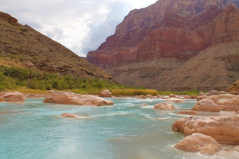
The turquoise waters of the Little Colorado River. Photo credit: Lyle Balequah/From the Earth Studio
Agriculture will be hit the hardest
Farming uses the largest chunk of water supply, accounting for 80% of consumptive water use in the U.S. and more than 90% in many Western states, according to the U.S. Department of AgricultureYour text to link…, and would likely be the first casualty if supply in the West were strained.
In Utah, up to 90% of the water used in the state goes to agriculture, The Salt Lake Tribune reported. In Arizona, a large amount of the water extracted from the Colorado River goes toward agriculture, Erinanne Saffell, acting Arizona state climatologist, told ABC News.
Overall, between 80% and 90% of the water from the Colorado River system is used for agriculture, Berggren said.
In California, about 80% of the water use goes toward irrigated farming, Lund said, but agriculture only accounts for about 5% of the economy…
Alternative solutions like desalination and groundwater aren’t always feasible
As water levels in reservoirs continue to drop, officials are also exploring other options to retrieve water.
In Arizona, groundwater is the state’s largest water supply, Saffell said. Lawmakers passed legislation in 1980 in which municipalities agreed to not overdraw the groundwater.
In the past, when there was not enough surface water and water in reservoirs, states would pump as much groundwater as needed, Cora Kammeyer, a senior researcher at the environmental research nonprofit Pacific Institute, told ABC News. But now, after turning to that solution “over and over again,” they are now seeing both surface water and groundwater shortages, she added.
Depletion of groundwater in the Southwest has been of concern for many years, especially in Arizona. Increased pumping to support population growth near Tucson and Phoenix resulted in water level declines of 300 to 500 feet in the region by the 1980s, according to the U.S. Geological Survey.
The installation of desalination plants, which remove mineral components from saltwater to create sources for drinking and agriculture, along the coast are for “some extreme cases,” Lund said, and with it comes “a whole host of challenges,” Berggren said.
The cost of treating seawater is about $2,000 to $3,000 an acre foot, which is about two or three times the cost of the next cheapest source, which is water conservation, such as buying water from farmers and reusing wastewater, Lund said. Relying on desalination plants would likely double a household water bill, he added.
And while the technology has been around for a while, desalination also presents environmental challenges, such as where to put the salt and sediments left over from the process, which are bad to return to the sea, because all the extra sediment and minerals essentially pollutes the natural seawater. It would also be inefficient to pump the water from the coast to more inland states such as Colorado, Berggren said…
Water management and conservation may be the strongest solutions
Water management and conservation have already proven to be the most effective tactics in maintaining water supplies in the West, experts said.
Arizona water management is well-equipped to ensure supplies to the desert community, Saffell said. The state has been at a Tier Zero level of shortage, the highest classification for a lake shortage, for the past couple of years. It decreases water allotment slightly, but Saffell expects the state to move to an unprecedented Tier One conservation level in 2022, when they will then decrease their draw rom the Colorado River by 8%.
It will be the first Tier One shortage ordered by the U.S. Bureau of Land Reclamation in lower Colorado River basin states such as Arizona, California, Nevada and some states in northern Mexico. Once Lake Mead, which supplies water to about 25 million people in the region, reaches a certain level, each state will have to extract less water, Berggren said…
With every drought in the West, officials have made improvements in water management, Lund said.
And the efforts to conserve have already made great strides in recent decades. in California, cities like Los Angeles and San Francisco are using the same amount of water, or less, as they did 30 years ago, despite substantial increases in population, Heather Cooley, director of research at the Pacific Institute, wrote in 2019.
Currently, per capita water use is 16% lower than 2013 levels, suggesting there has been some permanent behavior change by Californians since the mid-2010’s drought, California Gov. Gavin Newsom told reporters on Thursday…
Conservation mandates are imminent
Officials have already begun to lay down the law on curbing water usage, and additional restrictions are imminent, experts say.
Newsom requested that residents voluntarily use 15% less water after signing an executive order adding nine counties to the state’s drought emergency on Thursday…
On Wednesday, Oregon Gov. Kate Brown issued an executive order mandating that state agencies stop watering lawns and washing windows at state offices and facilities and to stop running fountains that don’t recirculate water. The order also bans the planting of new landscape that requires irrigation.