ON SEPTEMBER 24, WE WILL STRIKE TO DEMAND FOR INTERSECTIONAL CLIMATE JUSTICE! JOIN US!
The climate crisis does not exist in a vacuum. Other socio-economic crises such as racism, sexism, ableism, class inequality, and more amplify the climate crisis and vice versa. It is not just a single issue, our different struggles and liberations are connected and tied to each other. We are united in our fight for climate justice, but we must also acknowledge that we do not experience the same problems; nor do we experience them to the same extent.
MAPA (Most Affected Peoples and Areas) are experiencing the worst impacts of the climate crisis and are unable to adapt to it. This is because of the elite of the Global North who have caused the destruction of our lands through colonialism, imperialism, systemic injustices, and their wanton greed which ultimately caused the warming of the planet. With both the COVID, climate, and every crisis in history, overexploited countries and marginalized sectors of society are systematically left behind to fend for themselves.
The time to join the masses and follow the lead of our environmental defenders and workers has been long overdue. Reparations to MAPA must be paid for the historic injustices of the richest elite, vaccine equity, cancellation of debt, and climate finance are only the beginning of these. Together we will fight for a just future where no one is left behind. The historical victories of collective action have proven the need for the youth to stand united with the multisectoral, intergenerational struggle for a better future for all; a future where people and planet are prioritized.
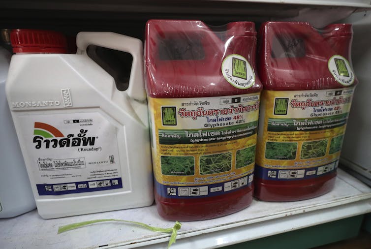
As North America enters its peak summer growing season, gardeners are planting and weeding, and groundskeepers are mowing parks and playing fields. Many are using the popular weed killer Roundup, which is widely available at stores like Home Depot and Target.
In the past two years, three U.S. juries have awarded multimillion-dollar verdicts to plaintiffs who asserted that glyphosate, the active ingredient in Roundup, gave them non-Hodgkin lymphoma, a cancer of the immune system. Bayer, a German chemical company, bought Roundup’s inventor, Monsanto, in 2018 and inherited some 125,000 pending lawsuits, of which it has settled all but about 30,000. The company is now considering ending U.S. retail sales of Roundup to reduce the risk of further lawsuits from residential users, who have been the main source of legal claims.
Glyphosate is now showing up in humans, but scientists are still debating its health effects. One thing is clear, though: Because it’s an effective and very cheap weedkiller, it has become pervasive.
Research on glyphosate’s possible human health effects in inconclusive, but concern is rising over its heavy use worldwide.
How glyphosate went global
When glyphosate was commercialized under the Roundup brand name in 1974, it was widely viewed as safe. Monsanto scientists claimed that it would not harm people or other nontarget organisms and did not persist in soil and water. Scientific reviews determined that it did not build up in animal tissue.
In the 1990s Monsanto began packaging glyphosate with crops that were genetically modified to be resistant to it, including corn, soybeans, cotton and canola. Farmers who used these “Roundup Ready” seeds could apply a single herbicide to manage weeds during the growing season, saving time and simplifying production decisions. Roundup became the highest-selling and most profitable herbicide ever to appear on the global market.
An employee arranging boxes of agricultural chemicals at a warehouse of Anhui Fengle Agrochemical Co. on Feb. 26, 2021, in Hefei, China. Ruan Xuefeng/VCG via Getty Images)
China still dominates the pesticide industry – it exported 46% of all herbicides worldwide in 2018 – but now other countries are getting into the business, including Malaysia and India. Pesticides used to flow from Europe and North America to developing nations, but now developing countries export many pesticides to wealthy nations. More pesticide factories in more places leads to oversupply and even lower prices, with critical implications for human health and the environment.
The question of whether glyphosate causes cancer in humans has been hotly debated. In 2015 the International Agency for Research on Cancer, an agency of the World Health Organization, classified it as a probable human carcinogen based on “limited” evidence of cancer in humans from actual real-world exposures and “sufficient” evidence of cancer in experimental animals.
There also are questions about possible linkages between glyphosate and other human health problems. A 2019 study found that children whose mothers experienced prenatal exposure to glyphosate had a significantly higher risk of autism spectrum disorder than a control population.
However, the U.S. Environmental Protection Agency and the European Food Safety Authority maintain that glyphosate is unlikely to cause cancer in humans and does not threaten human health when used according to the manufacturer’s directions.
A challenge for regulators
In the 1990s and early 2000s, the world community adopted several groundbreaking agreements to restrict or monitor sales and use of hazardous pesticides. These agreements – the Stockholm and Rotterdam conventions – target compounds that are either acutely toxic or persist in the environment and accumulate in animals, including humans. Glyphosate does not appear to meet these criteria, but humans may be more exposed to it because of its ubiquity in soil and water and on food.
Today a handful of countries, including Luxembourg and Mexico, have banned or restricted the use of glyphosate, citing health concerns. In most countries, however, it remains legal with few restrictions.
Scientists are unlikely to reach consensus soon about glyphosate’s health and environmental impacts. But that has also been true of other pesticides.
For example, DDT – which is still used in developing countries to control mosquitoes that spread malaria and other diseases – was banned in the U.S. in 1972 for its effects on wildlife and potential harm to humans. But it was not thought to cause cancer in humans until 2015, when scientists analyzed data from women whose mothers were exposed to DDT while pregnant in the 1960s, and found that these women were more than four times as likely to develop breast cancer than others who were not exposed. This study was published 65 years after the first congressional testimony on DDT’s human health impacts.
In 1946, health officials who believed incorrectly that polio was spread by insects ordered widespread fogging with DDT in San Antonio, Texas, decades before the pesticide’s health and environmental effects were understood.
Science can take a long time to reach conclusive results. Given how widely glyphosate is used now, we expect that if it is definitively found to harm human health, its effects will be widespread, difficult to isolate and extremely challenging to regulate.
And finding a cheap silver bullet to safely replace it could be hard. Many substitutes on the market today are more acutely toxic. Nonetheless, there’s a need for better options, because weeds are developing resistance to glyphosate.
In our view, growing concerns about glyphosate’s effectiveness and possible health impacts should accelerate research into alternative solutions to chemical weed control. Without more public support for these efforts, farmers will turn to more toxic herbicides. Glyphosate looks cheap now, but its true costs could turn out to be much higher.
This article has been updated to remove a reference to glyphosate detection in breast milk, which was based on a study that was not peer-reviewed.
The Bureau of Reclamation is awarding $1.14 million in WaterSMART Water Marketing Grants to seven projects in California, Colorado, Utah, and Washington. These grants will provide cost-shared financial assistance for the selected entities to develop water marketing strategies to establish or expand water markets or water marketing activities.
“Water markets and water marketing allow the movement of water between willing buyers and sellers under state and federal law,” said Chief Engineer David Raff. “These strategies will provide water managers more flexibility in addressing their water management challenges and reduce conflicts over water.”
These grants will support more than $2.6 million in water marketing planning activities including the recipients’ cost share. The seven selected projects are:
City of Vallejo Water Department, Water Marketing Strategy Development for Lake Curry Reservoir (California): Reclamation Funding: $200,000, Total Project Cost: $495,995
San Luis Rey Indian Water Authority, San Luis Rey Indian Water Authority Water Marketing Strategy Plan (California): Reclamation Funding: $200,000, Total Project Cost: $400,000
City of Thornton, City of Thornton Northern Properties Stewardship Plan: Water Optimization Market Feasibility Study (Colorado): Reclamation Funding: $275,000, Total Project Cost: $550,000
Rio Grande Water Conservation District, Colorado’s Rio Grande Basin Water Cooperative Project (Colorado): Reclamation Funding: $212,755, Total Project Cost: $425,511
Mt. Nebo Water Agency, South Utah County Water Banking Strategy (Utah): Reclamation Funding: $44,000, Total Project Cost: $88,460
Selah Moxee Irrigation District, Easy Moxie Declining Groundwater Area Water Marketing Strategy (Washington): Reclamation Funding: $150,000, Total Project Cost: $480,000
TransAlta Centralia Generation, LLC, TransAlta Centralia Water Marketing Strategy (Washington): Reclamation Funding: $60,000, Total Project Cost: $120,000
Through WaterSMART, Reclamation works cooperatively with states, tribes, and local entities to plan for and implement actions to increase water supply reliability through investments to modernize existing infrastructure and attention to local water conflicts. Visit http://www.usbr.gov/watersmart to learn more.
Colorado River “Beginnings”. Photo: Brent Gardner-Smith/Aspen Journalism
FromInkStain (Eric Kuhn and John Fleck). Click through and read the whole thing. Here’s an excerpt:
Unlike the Lower Colorado River Basin States, which have traditionally taken pragmatic and self-serving views of the 1922 Colorado River Compact, the Upper Basin States have largely shown the century-old document unwavering reverence.
The reverence comes from the way the agreement protected Wyoming, Colorado, Utah, and New Mexico against the avaricious impulses of fast-growing Lower Basin states, especially Arizona and California. The Compact promised water that has driven a century of development and dreaming in the Upper Basin.
Now, however, climate change-driven aridification has the Upper Basin in a vise-like squeeze. Increasing regional temperatures are reducing the river’s natural flow while the compact imposes fixed delivery (or non-depletion) obligations on the four Upper Basin States.
The net difference between the amount of water flowing from the Upper Basin’s watersheds and the amount that must be passed to the Lower Basin at Lee Ferry is the amount that can be consumed. As recent discussions about implications of “Alternative Management Paradigms for the Future of the Colorado and Green Rivers” by Kevin Wheeler, et al from the Colorado River Futures Project out of Utah State University have shown, state water officials from the upper river are beginning to understand that today’s law of the river places most of the future climate change risk on their states. But their fealty to the compact remains a major factor. (One of us, Eric Kuhn, is a co-author of the report. The other, John Fleck, serves on the project’s advisory committee.)
This dilemma raises the fundamental question facing the basin as it begins to negotiate the post-2026 river:
In recent months the paper’s authors have held briefings for state and federal water management agencies, water districts, and environmental NGOs. Most recently, they met (via Zoom) with representatives of the Upper Basin States under the umbrella of the Upper Colorado River Commission. Although the briefings varied in length and how deeply they got “into the weeds” concerning the modelling and science behind the study, the general messages and discussions were similar:
Balancing the river system’s water budget will require deeper cuts in total system water use than now contemplated by the basin Drought Contingency Plans. Further, future conservation targets and reservoir operations rules cannot be static. They will have to accommodate declining long-term average flows and increased variability. There is a general agreement that the post-2026 guidelines should work effectively down to a mean natural flow of 11-12 million acre-feet per year. Nevada’s John Entsminger suggested 11 maf at the University of Colorado’s Getches-Wilkinson Center Conference in 2019 – one of the last and most meaningful public conversations among the basin leadership before the pandemic shut us all down. For comparison, the estimated natural flow at Lee Ferry for the current 2000-2021 period is about 12.4 maf/year…
Our hope is that collectively, they will be open to a wide range of different future options and that they will pursue different options in parallel. We would also hope that one of those options is to recognize that we now have a fundamentally different river to manage than the one that their predecessors thought they had when the 1922 Compact, 1944 Treaty with Mexico, and 1948 Compacts were negotiated, therefore, managing today’s river may require breaking the chains that unnecessarily tie us to the past.
Those caught in the July 1 rainstorm said it was like weeks of monsoon rains — that came all at once.
Thursday evening’s deluge gave the entire county some much-needed moisture — but it flooded Salida’s main streets several inches deep in places, as the storm sewers couldn’t keep up. Tourists and visitors in downtown Salida scrambled to find shelter from the continuing downpour that began there just before 7:00 p.m., as the slow-moving front hung over the Arkansas River Valley.
The National Weather Service issued flood warnings throughout the area from late afternoon onward. As of 1:00 p.m. Friday, it again issued flood warnings across the Chaffee County area until at least 4:00 p.m. MST. They included the message that the storms have the potential for dangerous and life-threatening situations to develop…
The storm caused the infamous Chalk Creek Canyon “dip” to flow, closing CR 162 and routing residents and camping visitors to the canyon onto the gravelled back route south of Mt. Princeton Hot Springs, where the downpour had flooded parts of that county road as well…
Chaffee County quickly moved from immediate concerns over agricultural ditch water shortages and drought to flooding concerns, especially in the burn scar areas left by the Decker Fire and the Hayden Pass Fire.
While residents of Buena Vista reported much lower rain amounts, more than two inches fell in the Chalk Creek Canyon, with estimates of three to four inches in the southern half of the county…
Muddy torrents are shown above, coursing through the CR 111 flood diversion ditch in Salida. Earlier flows washed over the banks, as evidenced by the pooled waters on either side. Video courtesy of area resident Maureen Parsons.
In other parts of the south end of the county, localized flash floods occurred on the north side of Methodist Mountain. Most flood controls worked but there is damage reported between CR 110-111.
Flooding also appears to have happened up and downstream along the South Arkansas (unconfirmed at press time), which has had little water the past few days…
Residents of the Central Colorado Rockies know that what is called the “summer monsoon flow” is what we depend upon for summer moisture. The storm clouds that boil up over the Sawatch and Sangre de Cristo mountain ranges in mid-afternoon often bring short-lived showers, clearing again in time for evening barbeques.
Strong storms brought heavy rain to Colorado’s Front Range on Thursday, causing flash flooding in some areas with more rain likely on the way.
Many streets in Greeley experienced flash flooding on Thursday afternoon after torrential downpours dropped an estimated 3 to 4 inches of rain in about an hour over the city, according to the National Weather Service (NWS) in Boulder.
An unprecedented heat wave worsened drought conditions in Northwest, according to the US Drought Monitor. Record-breaking temperatures in Oregon and Washington dried soil and vegetation further, leading to an expansion of moderate and severe drought in that region.
Vast swaths of the West remain in a historic and unrelenting drought, the worst in the region in at least 20 years. The most severe conditions are centered in the Southwest in California, Nevada, Utah and Arizona. But areas of extreme and exceptional drought extend north as well into Oregon and Washington, where oppressive weekend heat dried out the ground and vegetation even more.
Climate change is playing a key role in these compounding crises: Drought and extreme heat are fueling wildfires; reduced snowpack and the lack of substantial precipitation are exacerbating water demands for millions of people, as well as agriculture, ecosystems and deteriorating infrastructure.
In addition to mandatory water restrictions already in place, even stricter cuts are looming amid the drought in some states as water levels plummet along the Colorado River.
Around 93% of the West is in some level of drought, up from 91% last week. Nearly 60% of the West is under ‘extreme’ or ‘exceptional’ drought — the two most severe classifications. It is the largest area of the West under those classifications in the 21-year history of the US Drought Monitor.
Conditions in much of the Southwest remained the same, though the drought in some areas, such as central Arizona, expanded. The drought has also sparked an increase in wildfire encounters in California, Nevada, and Utah.
The record-shattering heat waves in the Pacific Northwest also led to worsening drought conditions across the region.
As the planet warms, drought and extreme heat will also fuel deadly wildfires. Multiple studies have linked rising carbon dioxide emissions and high temperatures to increased acreage of burning across the West, particularly in California…
Stream and river flow
Streamflow, a measure of how much water is carried by rivers and streams, is another significant indicator of drought and its impact.
As drought conditions have worsened in 2021, hundreds of stream and river locations are experiencing below-average flow. More than 50 percent of the western monitoring stations reported lighter-than-usual flows. Fishing restrictions have also been put in place on many rivers in Montana due to low flows and warm waters.
Changes in streamflow affect the water supply for our own municipal use, crop irrigation and power generation.
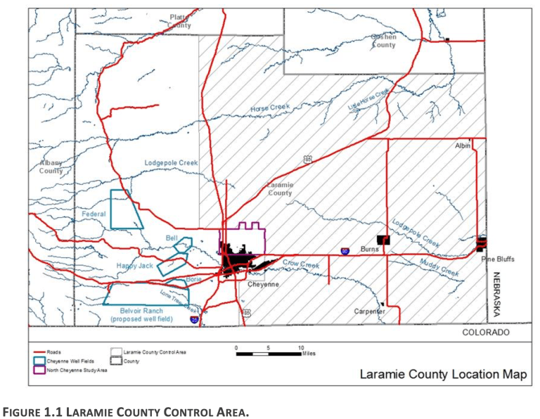
A Laramie County family said last week statutes and regulations obligate the state engineer to approve its plan to drill eight high-capacity water wells into the troubled High Plains Aquifer, a plan some neighbors strongly oppose.
Members of the Lerwick family made their case for the new wells in a three-day public hearing in Cheyenne that pit neighbor against neighbor. Farmers and ranchers living near the proposed development said it would draw water from the aquifer under their lands, imperiling springs, creeks and wells on which their operations depend.
If the project moves forward, opponents said, they will be left with unsatisfactory legal recourse. But expert witnesses called by the Lerwicks contested those claims, saying that there’s enough water for the development and that they’re not looking to harm their neighbors
The hearing stemmed from a 2019 application by Ty Lerwick, Keith Lerwick and Rod and Jill Lerwick to the State Engineer’s Office for eight permits to drill irrigation wells in the High Plains Aquifer system.
The proceeding’s purpose was to provide information to the Laramie County Control Area Advisory Board and the State Engineer’s Office. The advisory board will make a recommendation to the state engineer, who will then issue a decision on the Lerwick applications…
The various parties presented their cases, and participation was limited to the parties, their representatives and their identified witnesses. Those opposed to the Lerwick wells were identified as contestants, and the Lerwicks as contestees.
The applications would allow the Lerwicks to drill high-capacity wells that protesters say would draw more than 1.5 billion gallons from the ground each year. Several farmers and ranchers testified that they would have to drill new wells at significant cost to replace water sources that could be lost if the proposed wells are approved…
Epler even argued that approval could set a dangerous precedent for Wyoming.
The Lerwicks used their words sparsely throughout the proceeding. Rod Lerwick said his intention is to develop the water for irrigation, not harm his neighbors.
The area in question, which covers two-thirds of eastern Laramie County, is designated as the Laramie County Control Area. Since it was established in 1981, groundwater levels have continued to decline, according to the state engineer’s records. Despite that, in 2015, then-state engineer Pat Tyrell issued an order that created potential for new high-capacity wells to be drilled in the area.
Both the Lerwicks and their opponents contend that the law is on their side.
Evidence shows there is water available for appropriation in the aquifer and that law requires the state engineer to approve development that is of benefit to the public interest, according to the Lerwicks’ lawyer, Laramie attorney Bill Hiser. The state engineer could impose regulations on the Lerwicks’ development designed to protect the public interest, and that his clients would comply, Hiser said.
He also noted that guideposts are in place to ensure development proceeds properly. Not only would people who believe they’ve been injured by the development have an interference claim as a recourse, Hiser said, but the state engineer has the ability to monitor the development as it proceeds. (Hiser said there is “no chance” the Lerwicks would start eight new high capacity wells at one time.)…
Epler, attorney for the contestants, painted a different picture.
The Lerwicks’ permit applications are not legally sufficient, Epler said, pointing to what she saw as errors and omissions. The burden is on the applicants to demonstrate there is water available for appropriation in the source, and the Lerwicks failed to do so, she said.
The contestants’ position, Epler said, is that there is not, in fact, water available for the Lerwicks’ development. Granting the permits would only lead to more high capacity wells, she said, exacerbating the problem…
The rights of established water users needed to be considered, Mark Stewart, a Cheyenne attorney representing Lerwick-opponents at the Gross-Wilkinson Ranch, said. The ability to bring an interference claim, Stewart said, is an insufficient legal remedy.
“That’s too little too late,” Stewart said. “You’ve heard uncontroverted evidence that an injury to groundwater cannot be remedied immediately. It takes time to investigate, to determine the amount of injury, and it takes time to remedy and redress that.”
The development’s relative harm to the community would “far outweigh” the benefit to the Lerwicks, Conner Nicklas, a Cheyenne attorney representing Harding Ranch, Inc., said. Nicklas said his client had already seen water drying up in wells and on the surface, and estimated it would cost $500,000 to resupply water lost because of the Lerwick development…
Probing the ultimate purpose, contestants’ attorneys asked Lerwick about any plans to transfer water rights temporarily — potentially for significant profit — for oilfield use. Lerwick testified that he had not entered into third-party agreements to transfer water rights for fracking and that there was no third-party financing of the application…
Epler asked if there could be a profit incentive to eventually transfer water for fracking, to which Lerwick replied it was “possible, but not likely.”
Rod Lerwick said he has “nothing to hide” when it comes to the family’s plans for groundwater development. The plan for now, he said, is to use the development for irrigation.
When asked how he would feel if he were in the contestants’ situation, Rod Lerwick said he has thought about that, but doesn’t know if he would be among protesters to a permit application…
Expert testimony
Two expert witnesses testified for the Lerwicks that there is groundwater available for high-capacity irrigation wells in the Laramie County Conservation Area.
In 2012, the state engineer’s office contracted with AMEC Environment & Infrastructure to conduct a hydrogeologic study largely focused on the conservation area. The modeling depicted current aquifer drawdown compared to pre-development conditions, and also evaluated future groundwater level changes with several modeling scenarios…
Ben Jordan, senior hydrologist at Weston Groundwater Engineering in Laramie, said that the modeling in what’s known as the AMEC Report, as well as hydrographs and monitoring wells, tell him there is water available for appropriation in the district where the proposed wells would be located…
Jordan also said there “are tools in place to make sure harm is minimized,” whether that’s the state engineer putting certain requirements on the permit or the recourse of filing an interference claim…
The contestants responded with their own expert witnesses, who questioned the picture Jordan and Rhodes painted…
Russ Dahlgren, a hydrologist and engineer with Dahlgren Consulting, Inc., testified that he does not believe there is water available for a development like the one proposed by the Lerwicks. The AMEC model, he said, needs to be vetted, reviewed and modified. In an April 2020 letter to the State Engineer’s Office, Dahlgren wrote that the 2015 order that opened up the conservation area to high-capacity drilling should be discontinued and urged a moratorium on new high-capacity wells.
Dahlgren also testified that filing an interference claim takes a significant amount of time and effort. “I think we can do better than that particular standard,” he said.
The application now moves to the Laramie County Control Area Advisory Board, which has yet to set a date to consider the information gathered at the hearing.
Colorado Water Court for the Arkansas River Basin (Division 2) has issued a decree expanding the area within which the Upper Arkansas Water Conservancy District can provide augmentation water. The expansion includes parts of Custer and Fremont counties.
Attorney Kendall Burgemeister reported the news at the June meeting of the Upper Ark District board of directors. The decree is the culmination of a 3-year legal process that required the District to demonstrate its ability to provide replacement water and protect local water rights within the expanded boundary.
District General Manager Terry Scanga said the decree has already spurred several requests for water to replace evaporation from ponds within the new augmentation boundary, or “blue line.”
The Division 2 Engineer’s Office, Colorado Division of Water Resources, recently began evaluating ponds in the Arkansas River Basin for evaporative losses, identifying more than 10,000 ponds with no legal right to divert or store water.
An agency fact sheet describing the new pond management effort states, “For every acre of pond surface area, up to 1 million gallons of water is lost to evaporation each year.”
Under Colorado water law, water lost to evaporation from the ponds in question is injuring water rights owners by depriving them of water to which they are legally entitled.
The significance of these cumulative water losses prompted Division 2 Engineer Bill Tyner to implement the pond management initiative.
Tyner told Aspen Journalism, “Once we put the data together and we could look at the images of ponds and get a count of the number and relative sizes on average of those ponds, it did make us just very sure that this was a problem that could have some very negative consequences for the basin if we didn’t get more aggressive about the way that we took it on.”
Property owners within the new blue line are now seeking augmentation water from the Upper Ark District to avoid having to drain their ponds.
Scanga said the District’s agreements for pond augmentation are “curtailable.” During drought years, the district will stop augmenting ponds, and the pond owners will have to release water, which essentially provides a backup water supply.
Scanga said almost 50 parties filed statements of opposition in the case but that most opposers did not remain active in the case, including Custer County, prompting the judge to dismiss those filings “for lack of participation.”
Once stipulations were agreed upon with the handful of opposers did participate, the blue line decree was issued without the need for a trial.
From the USFS (Jonathan Hare) via The Montrose Press:
The Grand Mesa, Uncompahgre and Gunnison National Forests is planning to authorize Colorado Parks and Wildlife’s Spring Creek Reservoir Dam Outlet Rehabilitation Project.
The project would last approximately 90 days beginning August 2021. The purpose of this project is to address the most immediate maintenance concerns to reduce the risk of dam failure.
“In the fall of 2017, the U.S. Forest Service was approached by CPW with eminent structural concerns at Spring Creek Reservoir,” District Ranger Matt McCombs said.
“CPW and the USDA, Forest Service worked together to take immediate action to safeguard the dam and public safety. This project is a continuation of that important work and partnership.”
Work on U.S. Department of Agriculture, Forest Service lands would include the construction of a 625-foot access road to the dam’s outlet, repairs/upgrades of the outlet pipe and installation of a new gate stem and controller along with a reinforced grade beam with instrumentation for monitoring.
Reaching the outlet and upstream site for the grade beam requires the reservoir to be fully drained. To allow for the required work, CPW is actively drawing down the water in Spring Creek Reservoir.
The work proposed on Forest Service lands is expected to be cleared through the National Environmental Policy Act under a categorical exclusion. A preliminary evaluation of anticipated environmental effects indicate there are no extraordinary circumstances that would require preparation of an Environmental Assessment or Environmental Impact Statement.
For additional information, questions or concerns, please contact Jonathan Hare at 970-642-4445 or jonathan.hare@usda.gov.
The outflow at the bottom of Navajo Dam in New Mexico. Photo: Brent Gardner-Smith/Aspen Journalism
From email from Reclamation (Susan Novak Behery):
In response to decreasing flows in the critical habitat reach, the Bureau of Reclamation has scheduled an increase in the release from Navajo Dam from 500 cubic feet per second (cfs) to 600 cfs on Monday, July 5th, starting at 4:00 AM. Releases are made for the authorized purposes of the Navajo Unit, and to attempt to maintain a target base flow through the endangered fish critical habitat reach of the San Juan River (Farmington to Lake Powell).
The San Juan River Basin Recovery Implementation Program recommends a target base flow of between 500 cfs and 1,000 cfs through the critical habitat area. The target base flow is calculated as the weekly average of gaged flows throughout the critical habitat area from Farmington to Lake Powell.