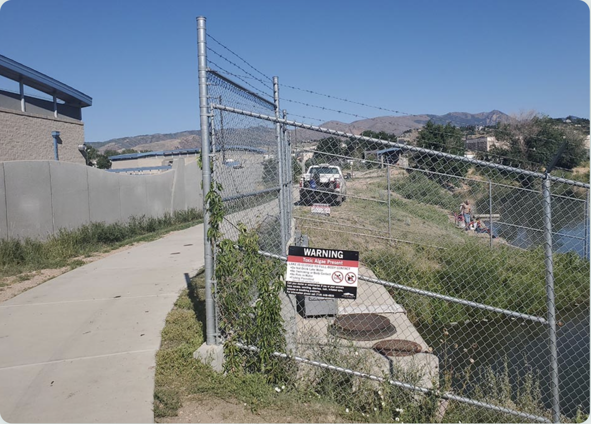
Warning sign for Blue-green algae at Pikeview Reservoir July 2021. Photo credit: Colorado Springs Utilities
Here’s the release from Colorado Springs Utilities:
Pikeview Reservoir, a popular fishing spot in central Colorado Springs and part of our water system, has tested positive for blue-green algae. While the reservoir is still safe for fishing, humans and pets are prohibited from entering the water until further notice. Anglers are directed to thoroughly clean fish and discard guts.
Pikeview has been removed as a source for drinking water until the reservoir is determined to be clear of the algae. There are no concerns about this affecting water supply for the community.
“It’s our responsibility to provide safe, reliable drinking water to our community and to always consider public safety at our reservoirs. We will continue to closely monitor our reservoirs and take appropriate actions,” Earl Wilkinson, Chief Water, Compliance and Innovation Officer said.
We conduct more than 400 water quality tests a month and collect approximately 12,000 water samples throughout our water system annually. With the increased risk of the blue-green algae, we are increasing the frequency of testing reservoirs at lower elevations.
In the past several years, there’s been increasing occurrence of toxic blue-green algae in reservoirs across the United States, forcing limitation of recreational access to the bodies of water for public safety.
Sickness including nausea, vomiting, rash, irritated eyes, seizures and breathing problems could occur following exposure to the blue-green algae in the water. Anyone suspicious of exposure with onset of symptoms should contact their doctor or veterinarian.
There is one climate topic that you’re likely to hear a lot about this year: tipping points.
In the context of climate science, a tipping point can occur when a relatively small change can have a large and irreversible effect on some of the Earth’s largest systems, such as the Antarctic ice sheets or the Amazon rainforest.
In the first post in our series on tipping points, we looked at the definition of tipping points. In the second of our series we literally go from pole to pole to examine the potential for huge change in the oceans and the cryosphere – the Earth’s wealth of ice.
Professor Tim Lenton – from the University of Exeter – is a world-renowned expert on tipping points. One tipping element (bits of the climate system that could pass a tipping point) that stands out as high risk for Professor Tim Lenton, is West Antarctica. Here there is physical evidence consistent with possibly having passed the tipping point for irreversible retreat of part of the ice sheet. Destabilization of the West Antarctica ice sheet could lead to about a three-metre sea-level-rise on a timescale of centuries to millennia. In a wider study Tim suggests that part of the East Antarctic ice sheet might similarly be unstable, with the potential to add another 3-4 m to sea level on timescales beyond a century.
He said: “We might already have committed future generations to living with sea-level rises of around 10 m over thousands of years. But that timescale is still under our control. The rate of melting depends on the magnitude of warming above the tipping point. More observational data will establish whether ice sheets are reaching a tipping point, and better developed models are needed to resolve how soon and how fast the ice sheets could collapse.” Tim.
Dr Ed Blockley, who leads the Polar Climate Group of the Met Office Hadley Centre, paints a similarly bleak picture for retreating Arctic sea ice. He explains that one challenge to understanding sea ice decline, is measuring the large seasonal and year-to-year variability against sustained long-term decline. However, over the past four decades, Arctic sea ice cover has reduced, on average, by 87,000 square kilometres, an area of more than four times the size of Wales each year. The Arctic has an important role to play in regulating climate, such as the albedo effect – where the expanses of white ice reflect the sun’s energy back into space – and atmospheric circulation patterns, which can influence the weather at lower latitudes such as in Europe.
Dr Blockley said: “One potential tipping point of Arctic sea ice is the ocean halocline, whereby cold, fresh water at the surface is less dense than warm, salty water below and currently prevents the warm water from reaching the surface and melting the sea ice. If the halocline were to collapse, this warm water, which contains enough heat to melt all the sea ice many times over, could mean that the Arctic would remain ice-free even if global warming were to be reversed.”
Tim Lenton added: “The Arctic is the place where a sort of cascade of unwelcome tipping point changes may be starting because it’s clearly the place that’s warming up two to three times as fast as the global average. We are also accumulating more evidence of casual interactions here as well, such as the role of Arctic sea-ice retreat and resultant warming in permafrost thawing. We appear to be approaching several tipping points.”
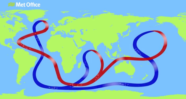
The global pattern of ocean circulation brings warm water into the North Atlantic and returns colder denser water southward. A global pump known as the Atlantic Meriodional Overturning Circulation.
Perhaps one tipping element more than any other attracts regular media headlines: the collapse of the Atlantic Meridional Overturning Circulation (AMOC). This huge conveyor belt brings warm salty water from the tropics into the northernmost reaches of the Atlantic. A weakening or collapse of this current could have devastating impacts on the climate of the northern Atlantic region, potentially switching off the transport of warm conditions to northern Europe.
Dr Richard Wood, head of cryosphere and oceans group at the Met Office Hadley Centre, explains: “If we were to add fresh water to the North Atlantic – such as from melting glaciers or increased precipitation run-off, for example – you would make the surface water fresher and less dense, weakening the ‘pump’ that drives the ocean circulation.”
Warming of the surface waters due to greenhouse gases has a similar effect of making the surface waters less dense and so weakening the ocean circulation pump. So there is a ‘double whammy’ of warming and freshening conspiring to weaken the circulation.
Dr Wood added: “Because the AMOC is a circulation that spans the whole globe, it’s a fundamental part of our climate system. We don’t think a collapse is imminent in the next decade or so, but climate models do suggest that over the 21st century, the AMOC will weaken, as greenhouse gases increase. We need to monitor for any early warning signals that the AMOC is getting near a tipping point.”
The Met Office’s second episode of our Mostly Climate podcast on Tipping Points can be found here.
Next time in the lasts of our tipping points series we’ll be travelling to the Amazon.
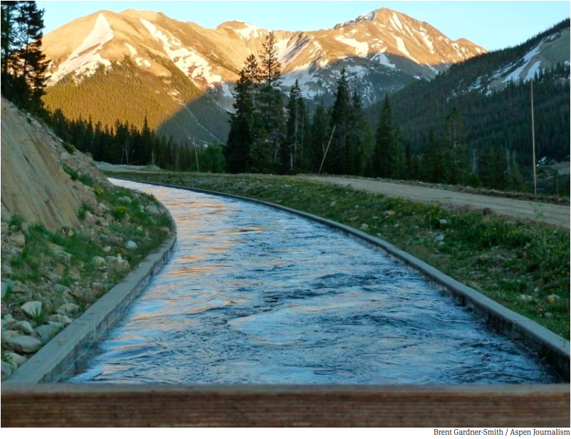
High up on Colorado’s Independence Pass, a narrow, winding road weaves through the evergreens and across mountain streams, up and over the Continental Divide at more than 10,000 feet. At one point that road crosses a canal.
It’s easy to miss if you’re not looking for it, but that canal is part of water infrastructure that makes life on Colorado’s Front Range possible.
The state has a geographical mismatch between where water shows up and where much of the population has settled.
“Wherever you are in this state, you’re either at the source of the drinking water supply, you’re in the middle of the drinking water supply, or you’re at the end of the tap,” said Christina Medved, outreach director at Roaring Fork Conservancy. “So on the Western slope, we are at the source of the water.”
About 80% of Colorado’s water falls on the western side of the state. Much of it is high-mountain snow and rain that eventually trickles down into streams and rivers like the ones on Independence Pass.
But about 80% of Colorado’s people live on the east side of the mountains. Because of gravity, that water doesn’t flow to them naturally. Instead, Colorado’s heavily-populated Front Range relies on a massive plumbing system to keep drinking water flowing to its taps.
Colorado transmountain diversions via the State Engineer’s office
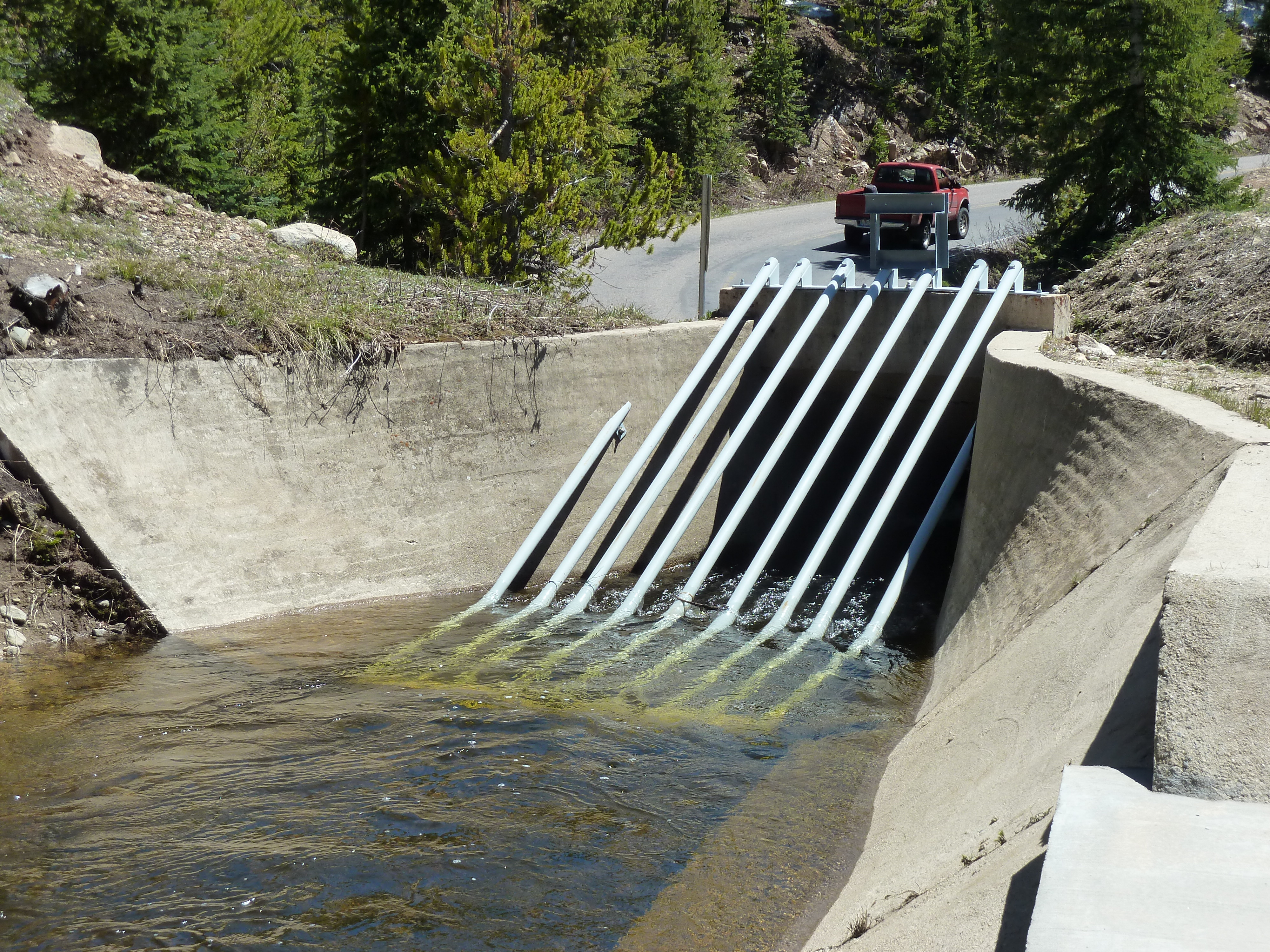
For a century and a half, engineers have carved up the mountains with tunnels and canals that pipe water across the state through trans-mountain diversions. Some of that infrastructure is nestled near the high-alpine headwaters of the Roaring Fork River, which eventually flows through Aspen and Glenwood Springs on its way to the Colorado River. Near Lost Man reservoir, a dam and tunnel create a juncture between water that will follow that natural path westward to the Colorado, and water that will be diverted eastward through the mountains and onto cities such as Colorado Springs.
A tunnel through the mountains draws in water that will pass through two reservoirs and the Arkansas River on its way to the southern portion of the Front Range. Water diverted from the Colorado River basin, through trans-mountain diversions, makes up 60 to 70% of the water used by Colorado Springs. Denver, Greeley, Fort Collins and smaller municipalities on the Front Range also rely heavily on Western Slope water.
And these kinds of set ups aren’t confined to Colorado. Similar systems bring water to big cities all across the region. Salt Lake City, Albuquerque and Los Angeles rely on canals and tunnels to ship faraway water into their pipes. New ones are in the works on the Front Range and in southern Utah.
But these systems aren’t without critics.
Water from the Roaring Fork River basin heading east out of the end of the Twin Lakes Tunnel (June 2016), which is operated by the Twin Lakes Reservoir and Canal Co., a member of the Front Range Water Council. Photo: Brent Gardner-Smith/Aspen Journalism
“When you first learn about it, the concept of a trans-mountain diversion is crazy,” said Andy Mueller, general manager of the Colorado River Water Conservation District. “It seems wrong. It seems antithetical to the health of the river. And I have to say all of that’s true.”
His organization was set up in the 1930s to oppose these diversions and ensure that there is enough water for people on the Western side of the state…
The issue is, contemporary environmental values aren’t written into the West’s water law. Instead, water use is defined by regulations written when Colorado first became a state in the 1800s. The rules say that if you have rights to use water, it doesn’t matter if you want to use it hundreds of miles away from its source – even if that requires miles of cross-mountain plumbing to do so.
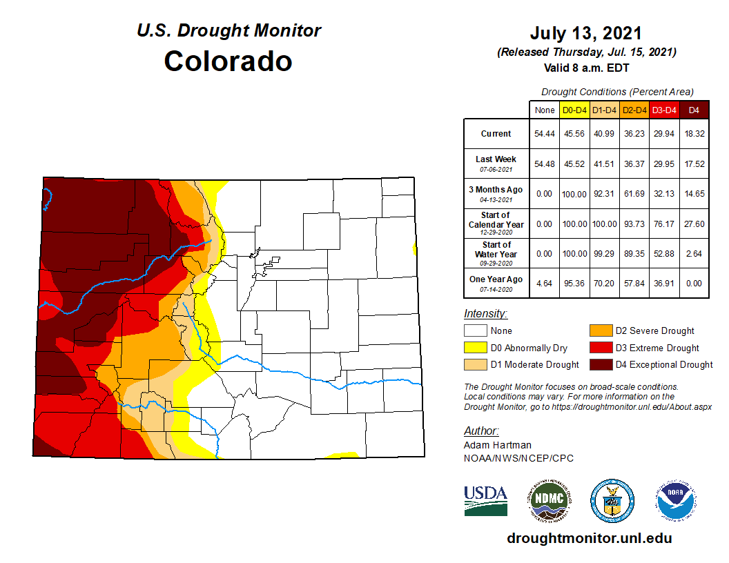
Colorado Drought Monitor map July 13, 2021.
At this moment, there is less water to pull from in every part of the state. The Front Range escaped from drought after steady spring rains, but those high-mountain areas that usually provide a dependable source of water for all of Colorado are experiencing a different fate. The western slope is deep in the second year of drought conditions, leaving snowpack and river flows lower than they should be.
Mueller thinks that only sharpens the need for the Front Range to curtail its water use. Although they retain the legal right to use a certain amount of water, he’s asking them to use less – which he says will promote the health of rivers and their ecosystems west of the divide.
The ditch that moves water from Lost Man Reservoir to Grizzly Reservoir and then under the Divide to the South Fork of Lake Creek and the Arkansas River.
On the Front Range, those on the receiving end of diversions say they are listening to their western counterparts when they put up distress signals during particularly critical times. They also say deliberate conservation work is paying off in the longer term. Nathan Elder, water supply manager for Denver Water, said over the past two decades, per capita water use in his district is down by 22%.
“Everyone in Colorado needs to decrease their use,” he said…
Amid tension between demands for water on both sides, exacerbated by extreme drought conditions, is the fact that there is not much of an alternative. Colorado’s water system is built to accommodate the fact that the majority of its people and the majority of its water are far from each other. Without fundamental changes to the bedrock of water law, those asking for water will have to work within a system built on trans-mountain diversions…
Some contingency planning – within the reality of a diversion-centric system – is already in place. In Colorado Springs, which receives some of the flow diverted from the top of Independence Pass, re-use practices are helping the city get more mileage out of the water it’s apportioned.
Graphic credit: Water Education Colorado
Abby Ortega, water resources manager for Colorado Springs Utilities, said reused water accounts for 26% of the city’s total portfolio and the city relies heavily on storage to get through dry years like this one.
Brad Udall: Here’s the latest version of my 4-Panel plot thru Water Year (Oct-Sep) of 2019 of the #coriver big reservoirs, natural flows, precipitation, and temperature. Data goes back or 1906 (or 1935 for reservoirs.) This updates previous work with @GreatLakesPeck
But climate change threatens to increase the frequency and intensity of droughts, which has water managers on edge and looking more intently at ways to maximize what’s available.
“Every water planner in the state has some worry with the rapidly declining hydrology on the Colorado river,” Ortega said.