It’s been said we no longer have fire seasons; we have fire years.
We all remember a year ago when fires ravaged our state and smoke choked the Colorado skies, leading to some of the most unhealthy air quality in the world and making the atmosphere glow red. Many of us remember checking in on friends and family, preparing go-bags in case the unthinkable happened, and watching flames tear through communities and places that had once been peaceful locations for recreation and communal gathering.
The same pattern has begun again.
What might not have been immediately obvious is that those fires have had long-term and damaging impacts on our natural infrastructure — watersheds, rivers, and waterways — hurting native fish populations, sending water quality to dangerously low levels, and weakening local economies. And, before Colorado has even begun to recover from last year’s devastating fire season — which saw the three largest fires in state history — fires have already started this year on the West Slope, forcing evacuations, road closures, and more. The recovery efforts and specter of last year’s blazes are still present as we begin to grapple with another intense and potentially catastrophic year. One bad fire season perpetuates another, and the cycle continues.
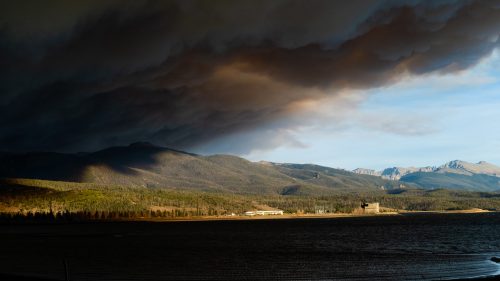
Smoke from the East Troublesome fire looms over Granby Reservoir. Photo credit: Evan Wise via Water for Colorado
Of course, fire is a natural part of a healthy forest ecosystem, and serves an ecological purpose; however, fire severity and frequency has been exacerbated by a combination of historical fire suppression and climate change. Today’s fires behave differently — and more destructively — than the type of fire that’s critical to forests’ ecosystems. This is why drought resilience and preparedness coupled with thoughtful wildfire mitigation and watershed restoration are all essential to prioritize; and why we’re grateful for the upwards of $65 million put towards these issues by the Colorado General Assembly and signed by Governor Polis this year. Moreover, at a recent convening of the Western Governors’ Association, President Joe Biden and Vice President Kamala Harris reinforced the need for — and their support of — greater resilience to climate change, drought, and wildfire. Local, state, and federal lawmakers are increasingly recognizing the urgency of our climate, drought, and fire crises, and understand the urgent need to work together now to address it.
Impacts Far and Wide to Our Rivers and Water
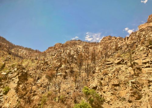
The Grizzly Creek burn scar above Glenwood Canyon and the Colorado River. Photo credit: Ayla Besemer via Water for Colorado
The effects of wildfires go well beyond the local burn scar; they impact entire watersheds and ecosystems, often for years. For example, the recent string of mudslides along the I-70 corridor in Glenwood Canyon and elsewhere throughout the state are the direct result of fire-damaged soil that can’t soak up heavy rains fast enough. The lack of tree root structure combined with dry soil leads to mudslides, causing infrastructure damage and, at its worst, loss of life.
Within streams, rivers, and riparian areas, the debris left behind by fires can impact water quality and fish health. Ash and debris flow into nearby waterways following fires, and often overwhelm water treatment plants, fill reservoirs with sediment, or lead to the need for costly repairs and maintenance. Around 80% of the United States’ freshwater supply flows from forested areas, which means forest fires will leave burn scars, ash, and other contaminants in watersheds, runoff from which will ultimately make its way into water treatment centers that send water to our homes.
In healthy forests, natural infrastructure acts as a filter for sediment and other pollutants that could otherwise wash downstream. In burn scars, where foliage and root systems are either gone or struggling to come back, this nature-based filtration system no longer exists. This puts even more pressure on towns and municipalities to treat contaminated water. (Following the 2002 Hayman Fire over 175,000 trees were planted in the South Platte River watershed to bolster natural infrastructure in the basin. Unfortunately, it wasn’t enough, and the water quality remains below average.)
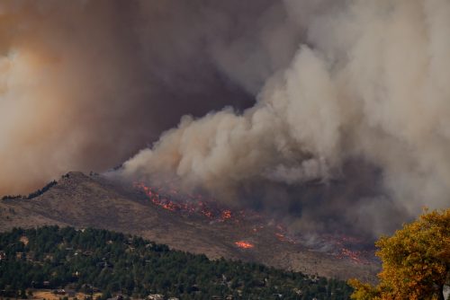
The Calwood Fire approaches Boulder, CO. Photo credit: Malachi Brooks via Water for Colorado
Fish, too, are dramatically impacted by fires both during and after the acute burn period. When a fire burns near a riverbed, heat causes the water temperatures to rise, oftentimes past the point that fish can reproduce or even survive. Changes to water chemistry during and after fires can cause devastating algal blooms and make the aquatic environment’s pH inhospitable to other life. A scientist studying the aftermath of a fire in alpine lakes discovered that the area’s fish had five times the amount of mercury as fish that weren’t affected by fire. And, the sediment runoff damages fish habitats and hurts the fishes’ ability to feed or reproduce. In 2018, following the 416 Fire, scientists estimated that around 80% of the Animas River’s fish population died off due to flooding and debris.
When fish are impacted by wildfires, the people, industries, and communities that rely on healthy fish populations also suffer. This summer, Colorado Parks and Wildlife asked anglers not to fish along a 120-mile stretch of the Colorado River due to high temperatures, low flows, and sediment runoff from wildfires, all of which are making it more difficult for fish to survive.
Prolonged drought only leads to a greater chance of fire, with dry forests and blistering temperatures. Governor Polis recently declared a State of Emergency in Western Colorado as the area enters its second consecutive year of “exceptional” drought — the highest classification given by the U.S. Drought Monitor — and a long-term megadrought continues to grip the entire Western United States.
What can we do to protect our rivers?
Understanding that fires, rivers, and communities exist within a connected ecosystem is the first step to mitigating the long-term impacts of drought and wildfire. The fires that hurt our towns, agricultural land, and favorite recreation areas also harm our rivers, watersheds, wetlands, and wildlife.
To ensure Colorado is ready to meet the challenges to our rivers and waterways posed by more severe and intense wildfires, we need to:
Work to ensure the Colorado Water Plan 2022 update reflects the need for an inter-connected understanding and management of watersheds, forests, and ecosystems. All of us need clean and reliable water, and for that we need healthy watersheds. Environmental priorities should be considered in every section of the Water Plan, as all other water needs are direct
ly related to water flowing from resilient, healthy, natural systems.
Educate ourselves and our friends, family, and community members about fire safety; and use that knowledge to work conscientiously on our own actions and impacts to reduce the risk of fire in our neighborhood watersheds.
Prioritize funding and continue to urge state, local, and federal lawmakers to increase funding and capacity for wildfire mitigation, prevention, and research and resilience to climate change, ensuring that state programs have the money necessary to develop and implement new strategies to address our ever-expanding wildfire seasons.
Things might seem dire, and they are. We must take action. There are steps we can take right now to reduce the risks wildfires pose to Colorado’s rivers. One such step is visiting the Colorado Water Conservation Board’s website and providing comments on the upcoming 2022 Water Plan update to ensure that environmental needs are met and that the Water Plan treats forests and rivers as the intertwined ecosystem they are.
This need for action and availability of solutions should increase our urgency and inspire us to work diligently towards resilience to climate change to ensure the health of our waters and watersheds now and into the future.
The Calwood Fire approaches Boulder, CO. Photo credit: Malachi Brooks via Water for Colorado
Smoke from the East Troublesome fire looms over Granby Reservoir. Photo credit: Evan Wise via Water for Colorado
Bent lodgepole pine in some areas revealed intensity of the wind. Photo/National Park Service via Big Pivots
Photo credit: Sylvan Fire Information Facebook page
This sign along the highway between Craig and Dinosaur, in northwestern Colorado, tells of a fire in 1988 that burned 15,000 acres, then the most in Colorado’s recorded history. The Cameron Peak Fire in 2020 burned nearly 209,000 acres. Photo credit: Allen Best via Big Pivots
Governor Jared Polis today signed an Executive Order memorializing a verbal disaster declaration from June 23, 2021, for the Muddy Slide Fire in Routt County. The Executive Order enables State agencies to coordinate for fire suppression, response, consequence management, and recovery efforts.
The images that define this drought are etched into the creek beds and hillsides of Summit County, their importance drawn out by experienced eyes that know how the land should look.
For one Summit County rancher whose operations cover vast swaths near Wyoming, the emblem might be the bare creek that’s never run dry this early, or the grass last year that grew so dry and brittle it blew away with the wind.
For a dairyman in Hoytsville, it might be the yellowing field that’s next to a still-green one, the result of hard choices after irrigation water was cut off earlier than in memory.
For a South Summit rancher and water official, it might be the hay they’re harvesting at almost half the yield of what it should be, or the low reservoirs that just keep emptying.
That official, Dave Ure, speaking just after a tour of waterworks facilities in Summit County, put the situation in stark terms.
“We are in the worst drought in the state of Utah’s history right now, and the only thing compared to it is the droughts back in 1895 and 1933,” Ure said.
The Ures have been in South Summit for 135 years. Dave Ure is a former politician and current trustee of the Weber Basin Water Conservancy District, which oversees many of the water sources in Summit County.
Ure said water will still flow from household taps, contending that the situation isn’t close to threatening culinary water, at least for those who are connected to a larger municipal system. Water will be diverted from agriculture users long before that happens, Ure said.
But that doesn’t mean the impacts will be confined to farmers and ranchers. Food prices can be expected to go up, Ure said, and wildfire risk will likely remain elevated. The drought might change the landscape itself, possibly hastening a trend of developing farmland into subdivisions.
Those impacts remain on the horizon, for now, but the impacts on farmers and ranchers are already here…
[Jeff] Young traced the current shortages to last summer. He said the 2019-2020 winter provided good water, but that it stopped raining in June and didn’t start snowing until November. A summer and fall without water was something he hadn’t seen before…
The dryness persisted into the winter, and even though there was a below-average snowpack, the season total was not devastating. But the drought was waiting underneath, with soils as dry as had ever been measured.
Ure said there is normally about 500,000 acre-feet of runoff water in the entire Weber Basin catchment area…
Young said the higher-elevation springs on the ranch are still producing, but that the lower areas are bone dry. He said the drought was already beginning to affect the underground aquifers.
Earlier this season, he went to the creek to fix what he thought was a problem with the water-capturing infrastructure.
“I was naive. I thought I had to fix the diversion, but there was nothing to get,” he said…
The Browns have water stored in a reservoir dug by their ancestors in 1883. But that reservoir was down significantly this year, and once that water is used, their fields will no longer be irrigated.
They won’t be able to grow as much feed for their cattle as they normally can, meaning they’ll have to buy it.
Hay prices have skyrocketed, they said, driven up by the lack of supply as well as the number of people who are in the market for feed.
Mike Brown flipped his phone over and showed a social media post from a friend asking if anyone had hay for sale…
With the drought forcing ranchers across the region to sell off portions of their herds, animals don’t fetch the same prices they once did.
All three said they had or were planning to sell significant portions of their stock.
Mike Brown said he has to call days ahead to reserve an appointment to send animals to slaughter. The packing plants are full, he said.
Liquidating the stock might get the ranchers out of debt, but it might not raise enough capital to restart a ranching or farming operation after the drought passes.
Moving the animals comes with transportation costs and the added challenge of finding areas unaffected by the drought, which stretches across much of the West…
Challenges to come
There aren’t many small ranching operations left in Summit County, Ure and others said, and this drought might just drive them out.
Young said it would likely change who’s in the ranching business, possibly opening the door to larger agriculture operations.
Ranchers could also opt to sell to housing developers…
Farmland that may have been profitable might not be so now, and the real estate market is red hot. Ure said he’d heard of several recent transactions in the Kamas area in which land sold for “outrageous prices.”
Summit County Councilor Chris Robinson, who owns or co-owns hundreds of thousands of acres in Utah and elsewhere, including Ensign Ranches, said one silver lining of what he called the “megadrought” is that it’s putting the appropriate level of scrutiny on water use…
Ure predicted that over the course of the summer, governments would start announcing water-conservation regulations. Some options include reducing the amount of grass installed in new development and incentivizing a switch to drought-resistant landscaping.
Young, Ure and Mike and Glen Brown agreed that if the drought persisted into next year, it would compound the problem to perhaps unmanageable levels.
Here’s the release from the Bureau of Reclamation (Patti Aaron):
The Bureau of Reclamation today released the July 24-Month Study, confirming declining hydrologic conditions for the Colorado River system. To protect Lake Powell’s target elevation, the study incorporates the implementation of drought operations under the Upper Basin Drought Response Operations Agreement (DROA).
The July 2021 Operation Plan for Colorado River System Reservoirs 24-Month Study (July 24-Month Study) shows that the Lake Powell water year 2021 predicted unregulated inflow volume has decreased 2.5 million acre-feet in the six-month period between January and July 2021. The current forecast for WY2021 is 3.23 maf (30% of average).
In addition, 5-year projections released by Reclamation last week predicted a 79% chance that Lake Powell would fall below the DROA target elevation of 3,525 feet within the next year. That target elevation provides a 35 vertical-foot buffer designed to minimize the risk of dropping below the minimum power pool elevation of 3,490 feet, and balances the need to protect the infrastructure at Glen Canyon Dam and meet current operational obligations to the Lower Basin States of Arizona, California and Nevada.
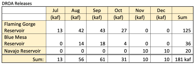
Consistent with DROA provisions to protect Lake Powell’s target elevation, the July 24-Month Study includes adjusted releases from the upstream initial units of the Colorado River Storage Project Act to deliver an additional 181 thousand-acre feet of water to Lake Powell by the end of December 2021. The additional releases are anticipated to be implemented on the following schedule:
Upper Basin Drought Response Operations Agreement (DROA) planned releases July 16, 2021. The “Last Flush”. Data credit: USBR
The releases detailed above are in addition to the already established releases determined by operational plans for each of the identified facilities. The additional delivery of 181 kaf is expected to raise Lake Powell’s elevation by approximately three feet. The additional releases from the upstream initial units do not change the annual volume of water released from Lake Powell to Lake Mead in WY2021, as those volumes are determined by the 2007 Interim Guidelines.
Reclamation publishes a 24-Month Study for Colorado River System reservoirs each month. The August 24-Month Study will set the operating conditions for Lake Mead and Lake Powell for the upcoming year. Reclamation will also release an update to the 5-year projections in early September.
Reclamation and the Colorado River Basin states continue to work together cooperatively to closely monitor projections and conditions and are prepared to take additional measures in accordance with the DROA.
Reclamation remains committed to reducing the collective risk of both Lake Powell and Lake Mead falling to critical elevations and will continue to work with entities in the Colorado River Basin to ensure that both facilities continue to function as authorized to meet the natural, municipal and agricultural needs of the basin.