Click on a thumbnail graphic to view a gallery of drought data from the US Drought Monitor.
US Drought Monitor map July 20, 2021.
High Plains Drought Monitor map July 20, 2021.
West Drought Monitor map July 20, 2021.
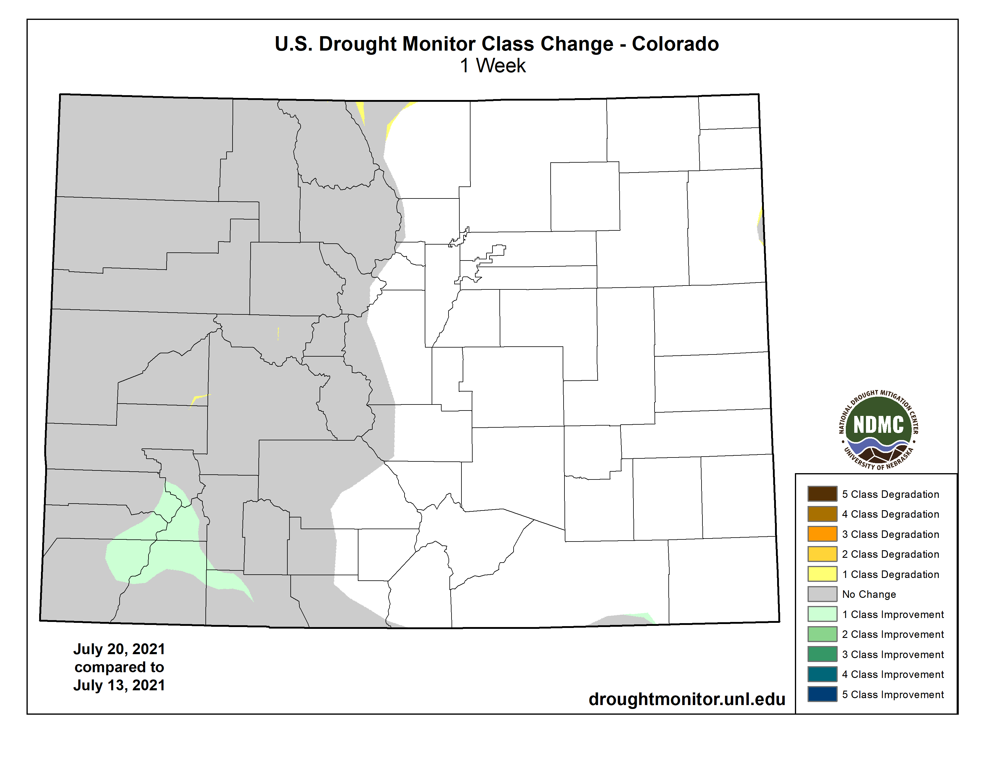
Colorado Drought Monitor map July 20, 2021.
Click here to go to the US Drought Monitor website. Here’s an excerpt:
This Week’s Drought Summary
Active weather prevailed across much of the South, East, and Midwest, as well as parts of the Plains, into the middle of July, followed by a southward shift in widespread shower activity. Meanwhile, a robust monsoon circulation provided limited Southwestern drought relief, particularly in parts of Arizona, New Mexico, and southwestern Colorado. Farther north and west, however, little or no rain fell in California, the Great Basin, and the Northwest, where dozens of wildfires were in various stages of containment. Smoke and other particulate matter from those fires carried downwind at various atmospheric levels, producing hazy skies and reducing air quality—in some cases thousands of miles from the points of origin. Dry weather extended eastward across the nation’s northern tier as far east as Lake Superior, while heavy rain eased or eradicated drought in the remainder of the Great Lakes region, along with the Northeast. In the driest areas of the northern and western United States, drought’s impact on water supplies, as well as rangeland, pastures, and a variety of crops, was further amplified by ongoing heat. Weekly temperatures averaged as much as 10°F above normal from the interior Northwest to the northern High Plains. On July 19, temperatures as high as 110°F were reported in eastern Montana. Another pocket of hot weather was centered over the middle Atlantic States. In contrast, near- or slightly below-normal temperatures dominated the Plains, Midwest, and South…
Scattered showers largely ended early in the drought-monitoring period. Meanwhile, extreme heat returned across northern portions of the region. Agricultural drought impacts across the northern High Plains remained widespread and severe, despite spotty showers. According to the U.S. Department of Agriculture, topsoil moisture on July 18 was rated 86% very short to short in North Dakota, along with 84% in South Dakota and 74% in Wyoming. Rangeland and pastures were rated at least one-half very poor to poor in Wyoming and the Dakotas, led by South Dakota at 78%. On July 18, North Dakota was the national leader in oats rated very poor to poor (50%; tied with South Dakota), along with soybeans (41%) and corn (32%). South Dakota led the nation, among major production states, in sorghum rated very poor to poor (29%). Nationally, the U.S. spring wheat crop was rated just 11% good to excellent and 63% very poor to poor on July 18, the lowest overall condition at this time of year since July 18, 1988, when the crop was categorized as 7% good to excellent and 73% very poor to poor. Initial estimates released by USDA on July 12 indicated that the 2021 U.S. spring wheat production will be down 41% from last year, while yield will be down 37%. If realized, the 2021 U.S. spring wheat yield of 30.7 bushels per acre would be the lowest since 2002…
Colorado Drought Monitor one week change map ending July 20, 2021.
Showers associated with the Southwestern monsoon circulation provided limited drought relief in Arizona, New Mexico, and southwestern Colorado, while drought generally worsened across the northern Rockies and interior Northwest. The Western drought continued to act on multiple time scales, ranging from a few weeks (mostly agricultural impacts) to two decades (ecological and hydrological effects). Dozens of wildfires, primarily across northern California and the Northwest, continued to burn through hundreds of thousands of acres of timber, brush, and grass, aided by hot, dry conditions, dry soils, and ample fuels. Wildfire smoke continued to degrade air quality in many areas of the country, well outside the West. In southern Oregon, the nation’s largest active wildfire—the lightning-sparked Bootleg Fire—has consumed more than 394,000 acres of vegetation and has destroyed at least 184 structures. Meanwhile, Washington led the country in several drought-related agricultural categories, according to the U.S. Department of Agriculture. On July 18, Washington’s topsoil moisture was rated 98% very short to short—highest on record since the beginning of the 21st century. Prior to this year, the Washington state record of 89% very short to short had been set on September 10, 2017. Washington also led the country on July 18 in very poor to poor ratings for rangeland and pastures (96%), spring wheat (88%), and barley (63%). In addition to Washington, at least one-half of the rangeland and pastures were rated very poor to poor on that date in Montana (89%), Arizona (88%), Oregon (74%), Utah (72%), Nevada (65%), and Wyoming (52%). Partly due to the stunning drought-related impacts on agriculture, extreme to exceptional drought (D3 to D4) was broadly expanded across eastern Washington and environs, as well as parts of Montana and neighboring states. Moving to longer-term impacts, some of the West’s largest reservoirs and lakes continued to exhibit startling declines. The surface elevation of Lake Mead, on the Colorado River behind Hoover Dam, fell 135 feet in the 21-year period from July 1, 2000, to July 1, 2021, from 1,204 to 1,069 feet above sea level. By July 20, Lake Mead’s elevation stood at 1067.79 feet. Prior to the 21st century, Lake Mead’s surface elevation briefly fell below 1,100 feet only during two drought periods: 1955-57 and 1964-65. Since March 2014, the lake’s end-of-month surface elevation has been continuously below 1,100 feet—and currently stands at a record low since impoundment occurred more than 80 years ago. Farther upstream, water is being released from Flaming Gorge Reservoir in Wyoming and Utah to boost the level of Lake Powell for the purpose of guarding hydropower generating capability. Elsewhere in Utah, the surface elevation of the Great Salt Lake fell to 4,191.4 feet on July 20, tying the previous record low set in 1963. In California, 154 primary intrastate reservoirs gained just 1.7 million acre-feet of water during the 2021 melt season, barely 20% of the historical recharge average of 7.9 million acre-feet. At the end of June, the 154 reservoirs held just 62% of their typical volume for this time of year—and had lost 16.6 million acre-feet of water (49% of the original volume) over the last 2 years. Current California storage (17.5 million acre-feet) is less than 5.8 million acre-feet above what those reservoirs held on June 30, 1977, which was the year when statewide storage ultimately fell to a record-low end-of-month volume of 7.5 million acre-feet at the end of October. Finally, the punishing Western drought has been accompanied by record-setting high temperatures. The most recent northward shift in heat occurred as monsoon-related showers intensified across the Southwest. By July 19, Glasgow, Montana, reported a maximum temperature of 110°F—the highest reading in that location since July 18, 1936. It was also Glasgow’s third-highest temperature (tied with June 17, 1933) on record, behind only 113°F on July 31, 1900, and 112°F on July 18, 1936…
South
Patches of dryness (D0) and moderate drought (D1) have been relegated to a few areas in Oklahoma, Tennessee, and Texas. Broadly, there are few drought-related impacts in the South. Frequent summer rain events have maintained adequate to abundant soil moisture. On July 18, Mississippi led the region with topsoil moisture rated 33% surplus, according to the U.S. Department of Agriculture…
Looking Ahead
The interaction between the Southwestern monsoon circulation and a weak cold front will result in locally heavy rain in the Four Corners States but only light showers on the drought-stricken northern Plains. Five-day Southwestern rainfall totals could reach 1 to 3 inches or more, mainly in parts of Arizona, western New Mexico, and southwestern Colorado. Meanwhile, little or no rain will fall in the Pacific Coast States, northern Great Basin, northern Rockies, and central and southern Plains. Flash drought could become a concern across the central and southern Plains and upper Midwest, where building heat will accompany the dry weather. Meanwhile, significant rainfall (1 to 2 inches or more) should be limited to the Great Lakes and Northeastern States, as well as parts of the Southeast. Higher totals may occur in peninsular Florida. Elsewhere, a significant hot spell will persist into next week across an area centered over the northern Plains, with heat-related impacts reaching into the northern Rockies, Intermountain West, central Plains, and upper Midwest.
The NWS 6- to 10-day outlook for July 27 – 31 calls for the likelihood of hotter-than-normal weather nationwide, except for near-normal temperatures in the Northeast, Desert Southwest, and southern and western Alaska. Meanwhile, near- or below-normal rainfall in much of the country should contrast with wetter-than-normal weather across the Intermountain West, northern Great Basin, and western Alaska.
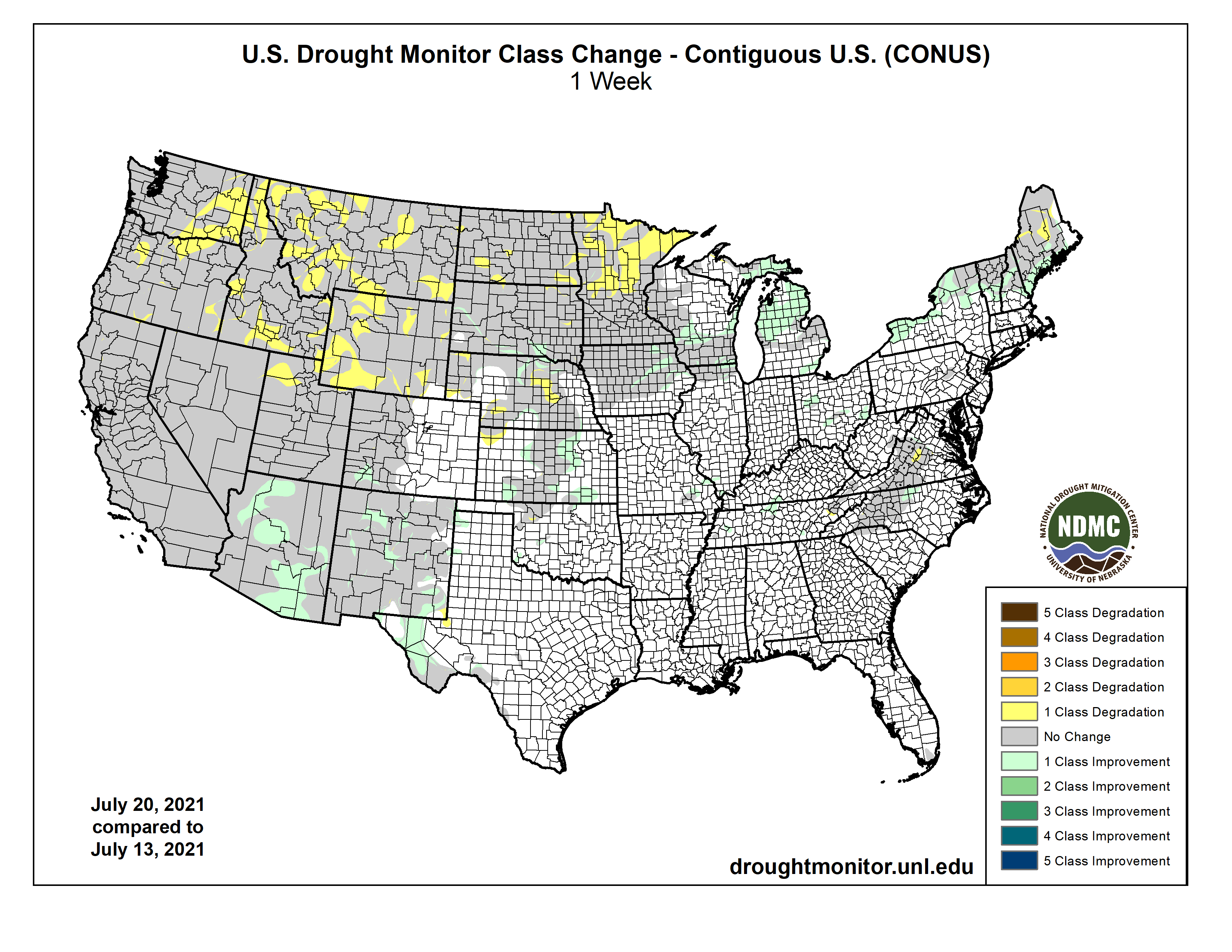
US Drought Monitor one week change map ending July 20, 2021.
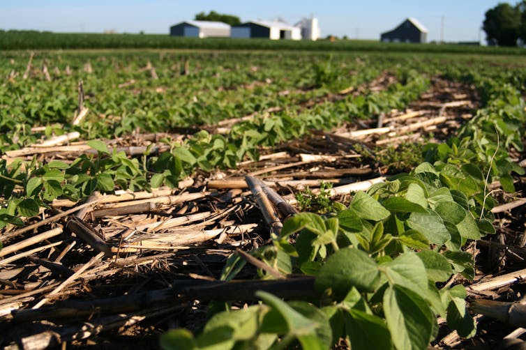
Soybeans sprout on an Illinois farm through corn stubble left on an unplowed field from the previous season – an example of no-till farming. Paige Buck, USDA/Flickr, CC BY
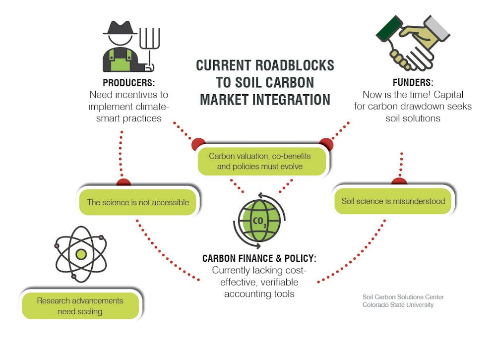
As the effects of climate change intensify and paths for limiting global warming narrow, politicians, media and environmental advocates have rallied behind “carbon farming” as a mutually beneficial strategy for society, the environment and farmers.
A free-range pig at the Stone Brns Center for Food and Agriculture in New York. Raising livestock and crops together can boost soil carbon through the animals’ grazing patterns and natural manure distribution. Francesca Cotrufo, CC BY-ND
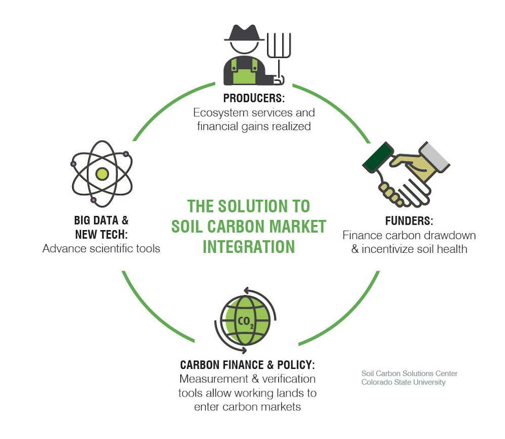
Given the momentum behind carbon farming as a climate change mitigation strategy, we believe now is the time to establish clear standards that ensure that only real net changes in carbon receive financial rewards.
Increasing carbon storage in soil can help stabilize the climate and support food production.
Carbon farming basics
As plants grow, they pull carbon from the atmosphere, and soil soaks it up and stores it. The amount of carbon stored varies significantly across soil type and climate.
Another climate-friendly strategy is raising livestock and crops together. Rotating cows among pastures allows grasses to recover from grazing, and the animals’ manure and the impacts of their grazing regenerate carbon in soils.
The deep roots of Kernza, a perennial grain, reduce erosion, help the plant tolerate drought and add soil carbon deeper in the ground than shorter-rooted annual grains. Kernza, the first commercially viable perennial grain in the U.S., was developed by The Land Institute, based in Salina, Kansas. Francesca Cotrufo, CC BY-ND
Carbon farming is also a potential revenue stream for farmers and ranchers, who can sell the credits they earn in carbon markets. Large-scale greenhouse gas emitters, such as manufacturers, purchase these credits to offset their own emissions.
Companies such as IndigoAg and Nori are already facilitating payments to farmers for carbon credits. And on June 24, 2021, the U.S. Senate passed the Growing Climate Solutions Act of 2021 by a vote of 92-8. The bill would authorize the U.S. Department of Agriculture to help farmers, ranchers and private forest landowners participate in carbon markets.
So far, however, there are no universal standards for measuring, reporting or verifying agricultural carbon credits. Here are the questions we see as top priorities.
Assessing carbon storage
One major challenge is that soils absorb varying amounts of carbon depending on depth, texture and mineral content. While certain practices increase carbon storage, quantifying how much is stored and for how long is critical for assigning dollar values to them. The markets and practices that work in different locations also vary widely.
Another priority is developing national minimum standards to predict and properly value soil carbon capture. Carbon may reside in soil anywhere from days to millennia, so time scale is an important consideration for markets. In our view, credits should reflect the duration carbon resides in soil, with full offsets generated only for longer-lasting storage.
We also believe that these programs must consider an operation’s net greenhouse gas emissions. For example, practices may store more carbon in soil but also increase emissions of nitrous oxide, another greenhouse gas.
Backed by effective technologies and policies, carbon farming can improve ecosystems and help to slow climate change. CSU Soil Carbon Solutions Center, CC BY-ND
Benefits and challenges
Rebuilding carbon-rich soil supports farmers’ bottom lines by improving soil health and increasing crop yields. But federal incentives could preferentially provide resources to big operations that have greater ability to sequester carbon on their vast acreage.
Ultimately, the goals of climate policy include curbing greenhouse gas emissions and actively removing carbon dioxide from the atmosphere. Before farmers receive soil carbon credits they can sell to offset other sources of emissions, we believe their value must be accurately assessed to ensure that society gets what it pays for.
Editor’s note: This article has been updated to reflect that IndigoAg does not purchase carbon credits.
The U.S. Bureau of Reclamation (Reclamation) recently shared alarming news about the unprecedented conditions on the Colorado River and I’ll attempt to explain their complicated projections. Reclamation, the agency that oversees federal water management across 17 western states, publishes some pretty wonky information, even to those of us who regularly interface with this agency and rely on its analyses.
Just last month, in June, Reclamation shared their new 5-year projections for the Colorado River Basin to further assist drought management within the Basin. They share these projections a few times every year. The big news is that the water situation on the Colorado River is worse than folks anticipated when adopting the shared shortage agreements called the Colorado River Drought Contingency Plans (DCPs) adopted in 2019.
To jump to the conclusion: Reclamation’s projections signal that we urgently need to do more than the DCPs envisioned because of the increasingly hot and dry conditions in the basin. Reclamation has continued to revise their projections throughout this shockingly dry spring, resulting in really dire projections for water storage and distribution. In other words, less water for people, and less water in streams that benefit birds, fish, and a robust recreational economy.
We’ve arrived at the time when the limits of the Colorado River are being reached.
What does this mean for birds? Birds rely on the riparian habitats of the Colorado River and its tributaries and aquatic birds have come to rely on the big reservoirs on the river too. Surveys of aquatic birds at Lake Powell have documented dabbling ducks, diving species, shorebirds, and more. American Coot and Western Grebe are common. Gadwall, Common Goldeneye, Redhead, and Green-winged Teal have also been observed. The habitats created by Lake Powell have existed for less than 60 years and can change with the lake level, which can affect birds.
You may recall that the main reservoirs on the highly-plumbed Colorado River—Lake Powell and Lake Mead—sometimes “equalize” in water accounting flows. Lake Powell is the receiving reservoir from the Upper Basin states (Wyoming, Colorado, Utah, and New Mexico) meaning that it stores water that runs downstream from these states. Lake Mead is the distributing reservoir for the Lower Basin states (Arizona, Nevada, and California) and Mexico meaning that water deliveries to each of these places comes from available water in this lake (and legal water rights, of course). The amount of water in Lake Mead—the largest reservoir in the country—determines how much water a state has available for their Colorado River water users.
Reclamation projects that Lake Mead water levels are, for the first time ever, so low that they will require cuts in water Lower Basin water deliveries, operating in Tier 1 shortage. And they say there is a greater than 99% chance of this shortage in 2022 and a high risk (greater than 80% probability) that Lake Mead will remain under shortage operations for at least the next five years, perhaps with even more aggressive cuts.
Severe drought conditions are also triggering emergency response (outlined in the Upper Basin Drought Response Operations Agreement as part of the DCP here on page 7) whereby Reclamation will release water from reservoirs further upstream to address declining water levels at Lake Powell and protect the ability of the Glen Canyon Dam to generate hydropower. Representatives from Reclamation and the Upper Basin states just announced they will release water from Flaming Gorge and other reservoirs.
If we have another bad water year, elevations at Lake Mead could even be lower than before Lake Powell was created. It’s getting to the bottom for both of these reservoirs.
Why does this matter? These unprecedented and exceptional drought conditions are a signal to all of us to take steps to ensure the river flows long into the future and address water security for people and wildlife. The entire Colorado River Basin is in crisis.
Climate change is here. We have a very limited window to begin implementing innovative tools that are at our disposal in order to adapt to and mitigate climate change. In addition to reductions in carbon emissions and other large-scale solutions for our planet, Audubon continues to focus on federal and state investments in climate resilient strategies that will help stabilize water supplies and better assist economic sectors and ecosystems adapt to changing conditions. Future water projections by Reclamation – and future agreements on the Colorado River – need to account for climate extremes.
The effects of prolonged drought and climate change affect everyone in the basin. Our way of life is at stake—millions of acres of farmland and ranches, urban and rural communities, recreation on rivers and lakes, our economies, as well as incredible bird life. Our work is more urgent and more difficult. Please join us in advocating for climate solutions that benefit the Colorado River and other important rivers in the West. Sign up for updates here.
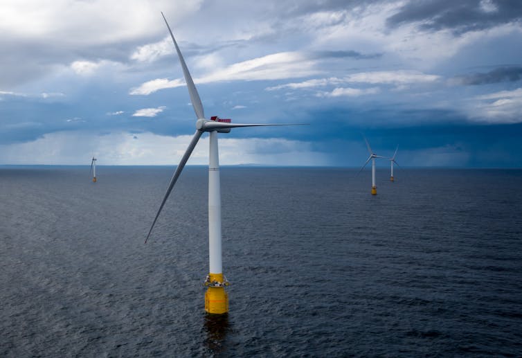
Northern California has some of the strongest offshore winds in the U.S., with immense potential to produce clean energy. But it has a problem. Its continental shelf drops off quickly, making building traditional wind turbines directly on the seafloor costly if not impossible.
Once water gets more than about 200 feet deep – roughly the height of an 18-story building – these “monopile” structures are pretty much out of the question.
A solution has emerged that’s being tested in several locations around the world: making wind turbines that float. In fact, in California, where drought is putting pressure on the hydropower supply and fires have threatened electricity imports from the Pacific Northwest, the state is moving forward on plans to develop the nation’s first floating offshore wind farms as we speak.
So how do they work?
Three main ways to float a turbine
A floating wind turbine works just like other wind turbines – wind pushes on the blades, causing the rotor to turn, which drives a generator that creates electricity. But instead of having its tower embedded directly into the ground or the sea floor, a floating wind turbine sits on a platform with mooring lines, such as chains or ropes, that connect to anchors in the seabed below.
These mooring lines hold the turbine in place against the wind and keep it connected to the cable that sends its electricity back to shore.
Most of the stability is provided by the floating platform itself. The trick is to design the platform so the turbine doesn’t tip too far in strong winds or storms.
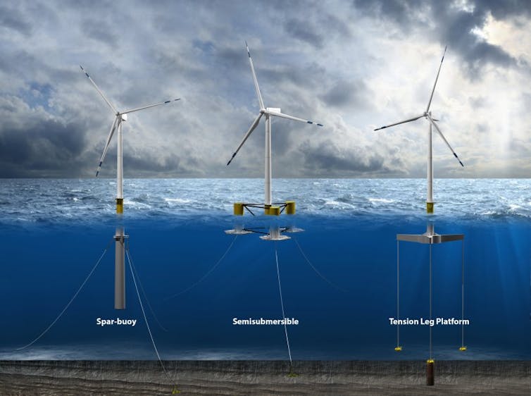
Three of the common types of floating wind turbine platform. Josh Bauer/NREL
There are three main types of platforms:
A spar buoy platform is a long hollow cylinder that extends downwards from the turbine tower. It floats vertically in deep water, weighted with ballast in the bottom of the cylinder to lower its center of gravity. It’s then anchored in place, but with slack lines that allow it to move with the water to avoid damage. Spar buoys have been used by the oil and gas industry for years for offshore operations.
Semi-submersible platforms have large floating hulls that spread out from the tower, also anchored to prevent drifting. Designers have been experimenting with multiple turbines on some of these hulls.
Tension leg platforms have smaller platforms with taut lines running straight to the floor below. These are lighter but more vulnerable to earthquakes or tsunamis because they rely more on the mooring lines and anchors for stability.
Each platform must support the weight of the turbine and remain stable while the turbine operates. It can do this in part because the hollow platform, often made of large steel or concrete structures, provides buoyancy to support the turbine. Since some can be fully assembled in port and towed out for installation, they might be far cheaper than fixed-bottom structures, which requires specialty boats for installation on site.
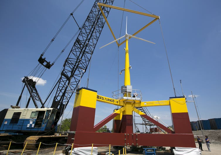
The University of Maine has been experimenting with a small floating wind turbine, about one-eighth scale, on a semi-submersible platform. It plans to launch a full-scale version with corporate partners in 2023. AP Photo/Robert F. Bukaty
Floating platforms can support wind turbines that can produce 10 megawatts or more of power – that’s similar in size to other offshore wind turbines and several times larger than the capacity of a typical onshore wind turbine you might see in a field.
Why do we need floating turbines?
Some of the strongest wind resources are away from shore in locations with hundreds of feet of water below, such as off the U.S. West Coast, the Great Lakes, the Mediterranean Sea, and the coast of Japan.
In May 2021, Interior Secretary Deb Haaland and California Gov. Gavin Newsom announced plans to open up parts of the West Coast, off central California’s Morro Bay and near the Oregon state line, for offshore wind power. The water there gets deep quickly, so any wind farm that is even a few miles from shore will require floating turbines. Newsom said the area could initially provide 4.6 gigawatts of clean energy, enough to power 1.6 million homes. That’s more than 100 times the total U.S. offshore wind power today.
Some of the strongest offshore wind power potential in the U.S. is in areas where the water is too deep for fixed turbines, including off the West Coast and offshore from Maine. NREL
Globally, several full-scale demonstration projects are already operating in Europe and Asia. The Hywind Scotland project became the first commercial-scale offshore floating wind farm in 2017, with five 6-megawatt turbines supported by spar buoys designed by the Norwegian energy company Equinor.
While floating offshore wind farms are becoming a commercial technology, there are still technical challenges that need to be solved. The platform motion may cause higher forces on the blades and tower, and more complicated and unsteady aerodynamics. Also, as water depths get very deep, the cost of the mooring lines, anchors, and electrical cabling may become very high, so cheaper but still reliable technologies will be needed.
Expect to see more offshore turbines supported by floating structures in the near future.