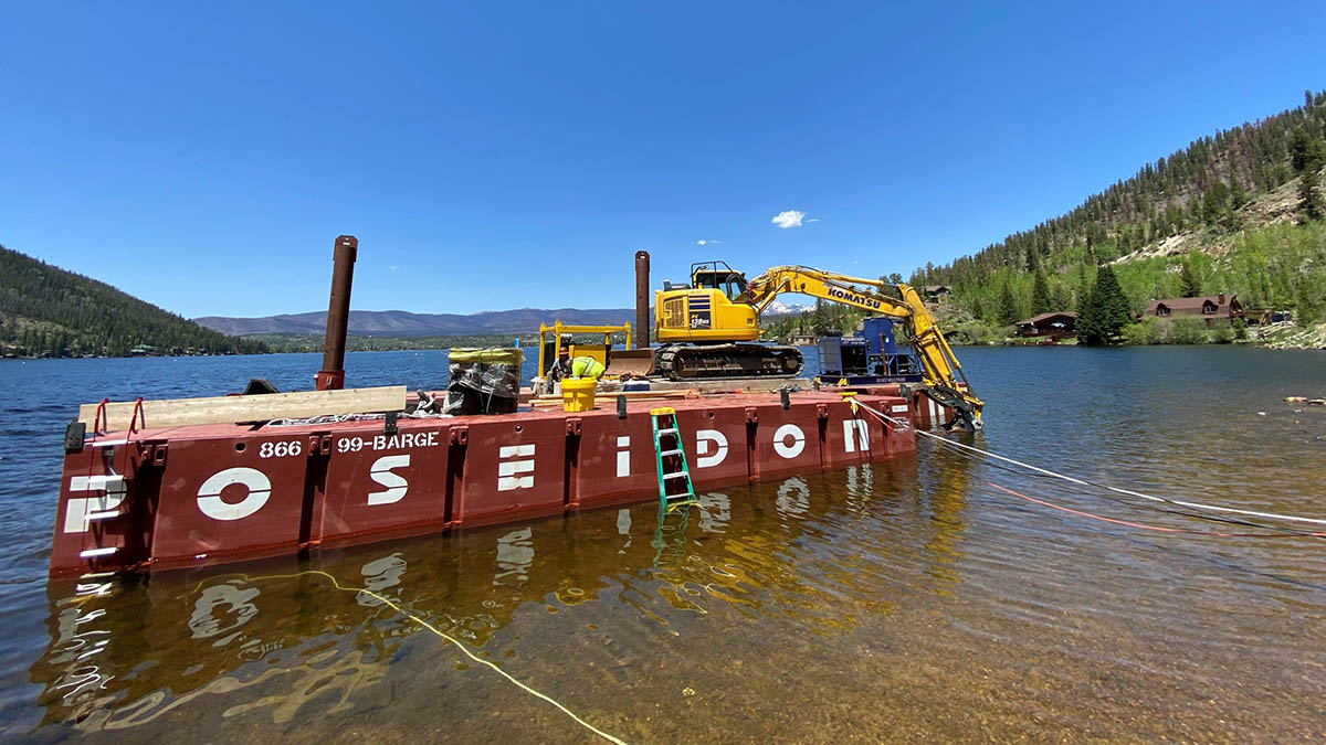
A work crew prepares to install a debris boom at Grand Lake. The boom will prevent floating debris from entering the Alva B. Adams Tunnel. Photo credit: Northern Water
While new wildfires across Colorado and the West are creating another year of smoky skies and damaged forests, work to contain debris and restore watersheds damaged by the East Troublesome Fire has started taking shape in Grand County.
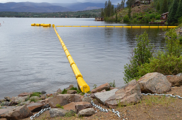
This month, crews started to place a series of booms at the east end of Grand Lake to capture floating debris that could move into the lake from heavy rainstorms that sometimes occur in the summertime. The bright yellow booms are anchored near the intake to the Alva B. Adams Tunnel, which delivers water from the West Slope to the East Slope components of the Colorado-Big Thompson Project.
In addition to the boom at Grand Lake, two more will be installed at Willow Creek Reservoir to capture debris from that heavily affected watershed. According to damage assessments, more than 90 percent of the Willow Creek watershed suffered damage in last October’s fire.
Work will also be concentrated to capture debris before it reaches the reservoirs. Starting in July, helicopter crews will drop mulch and seeds on burned areas that are inaccessible to ground-based efforts. That material will help to keep soil and debris in place, and in future years will provide appropriate ground cover at those sites.
Other methods for debris containment to be installed include catchment basins where smaller tributaries might be transporting loosened materials.
Funding for the efforts has come from the federal Natural Resources Conservation Service’s Emergency Watershed Protection program and state matching funds from the Colorado Water Conservation Board.
Finally, Northern Water has also provided a self-service site in Grand Lake where property owners can get sandbags and wattle to protect their property from high-water flows that might occur this year or in the future. In May, employees of Northern Water and Grand County volunteered to fill sandbags using equipment donated by the Salvation Army.
Because of the importance of the Upper Colorado River watershed to the Colorado-Big Thompson Project and the drinking water for more than 1 million residents in Northeastern Colorado, Northern Water has taken a lead role with Grand County as local sponsors for the Emergency Watershed Program.
The final position of the debris boom at Grand Lake will protect the inlet to the Alva B. Adams Tunnel. Photo credit: Northern Water
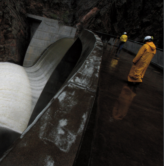
Safety inspectors walk on top of the Crystal Dam in the Black Canyon of the Gunnison National Park in May 2008, when high snowpack and warm temperatures prompted reservoir managers to make more room through a managed release, or spill. The reservoir spilled most recently in May 2019. Photo by William Woody
To address the water needs of a growing population amid shortages, the Colorado Water Plan in 2015 set a goal of attaining 400,000 acre-feet of new water storage by 2050.
Colorado is working its way toward that goal, but building new storage is easier said than done. Increasing environmental and social concerns, limited geographic locations, and even more limited water rights have made many traditional reservoir storage projects tougher to build. On top of that, long-range forecasting — to figure out how much water is going to be available to be stored — has become especially difficult as a result of climate change.
An April 2020 study published in the journal Science found that the American West’s current drought is as bad or worse than any in the past 1,200 years of tree-ring records. Ordinarily, storage would be the obvious solution to drought and dry years. You collect moisture in wet years and save it for times of need. But climate change has created a catch-22. Storage may be necessary, but it has become more challenging to build and less water is available to capture.
Dan Luecke, former director of the Environmental Defense Fund’s Rocky Mountain office, says these challenges have upended a philosophy long built on risk analysis to one defined by “decision-making under uncertainty.”
“For a long time, we’ve known there’s risk but we could look to the historical record to manage it,” says Luecke. (Luecke also serves on the Water Education Colorado Board of Trustees). “With climate change, that record is called into question … The nature of the game has changed.”
The cascading challenges of climate change have led water managers to think creatively about alternatives to traditional infrastructure. Greeley, for example, replaced a plan to expand an existing reservoir with one that will store water underground. Front Range districts collaborated to reallocate the space in Chatfield Reservoir, a flood storage basin, raising the water level to add permanent water storage supply. As part of the Basin Implementation Plan for the Yampa/White/Green River Basin, water managers are exploring putting reservoirs high in the mountains to limit evaporative loss.
Decision-making under uncertainty makes it all the more complicated for water providers to meet Colorado’s water needs and has caused many to reexamine what a smart storage project is made of — one that can help meet water supply goals for many water users while respecting the environment, one that is also acceptable to stakeholders, and one with minimum impacts so that it can make its way through the permitting process. Water managers are growing increasingly innovative, out of necessity, to develop water storage projects that will work.
Reservoirs under Climate Change
It’s not simply a matter of how much water is available to store. Everything from the location and size of reservoirs to the timing for capturing runoff and for making releases is being reviewed. Various climate models, including those used by the Colorado Water Conservation Board for state water planning, project warmer temperatures that will affect evaporation rates in rivers and reservoirs and seasonal shifts in precipitation, including reduced mountain snowpack and earlier runoff. Earlier and reduced flows could, for instance, necessitate dams releasing water earlier to meet demand.
Temperature rise, too, makes storing water a challenge. Any pool will lose water through evaporation, and more during hot, dry times, but the loss is worse for reservoirs at lower elevations with more exposed surface area. The science used to estimate evaporative loss is imprecise — estimates could be off by as much as 20 to 30 percent, according to the U.S. Bureau of Reclamation, which is conducting a study to refine its methods. Even so, a 2018 Bulletin of the American Meteorological Society study estimated that losses from Lake Powell and Lake Mead could total as much as 15% of the annual upper basin allocation among Colorado River Basin states, or five to six times the annual water use of Denver. The same study said that summer evaporation rates may have risen by as much as 6% over the last 25 years.
The National Climate Assessment, published in 2018, states that climate change is fueling stronger storms that could overwhelm dams and infrastructure designed to capture more moderate storm surge flows. It’s also intensifying wildfires that destroy landscapes, load reservoirs with sediment, and threaten water delivery infrastructure.
The 2019 Technical Update to the Colorado Water Plan lays out a number of alternatives to new traditional storage projects, including rehabilitating existing infrastructure, reallocating flood storage to active storage, and using below-ground aquifer storage alternatives. While the options are vast, the update says that to meet the state’s goals, “at least some new large reservoirs are needed.”
But building those reservoirs also requires water to fill them, says Brad Udall, senior water and climate research scientist at Colorado State University. Water rights are not as easy to come by in an era of constraint. Any new water rights claimed today are junior in the state’s legal priority system, making storage necessary to capture peak flows after all senior water rights are satisfied. But as climate change shifts the timing and magnitude of peak flows, reservoirs may not be as effective a tool for managing junior water rights.
“A dam is a bit like opening a bank account, there has to be something to put in it,” Udall says. “Ultimately, everything bends to the hydrological realities of what the supply is.”
The Jigsaw Puzzle
The era of uncertainty doesn’t just make individual storage projects a puzzle — the long-range plans that help utilities figure out what storage they need are now a tangle of variables. Balancing climate-complicated precipitation projections with population and water use trends, regulatory changes, and competition for resources can make the standard planning process a head-spinning endeavor.
When Colorado Springs Utilities started updating its 2017 Integrated Water Resource Plan (IWRP), the utility wanted a “comprehensive view” that would take a hard look at risk analysis, says water planner Kevin Lusk. Colorado Springs doesn’t sit on a major river system and relies on storage in remote watersheds to manage its variable supply. In the early 2000s, the utility’s water yield saw a 600% difference between the driest and wettest years.
Realizing that a backward-looking dataset might no longer apply to a present and future defined by climate change, the utility took a state-of-the-art new approach to its planning process. Recently, Colorado Springs partnered with the consulting firm Black and Veatch, which expanded the multi-objective evolutionary algorithm (MOEA) to utilities to help them assess the complexities in planning. The machine learning tool can project thousands of possible futures using precipitation, temperature and hydrological factors, then help planners narrow down their range of possible options.
“As these plans get so big, it’s hard for the human mind to comprehend them,” says Leon Basdekas, a private consultant who worked at Colorado Springs Utilities, then Black and Veatch, designing and managing the utility’s IWRP. “This tool allows you to evaluate complex planning options in ways that would be impossible to do otherwise.”
Leon Basdekas, pictured beside Monument Creek, worked with Colorado Springs Utilities using a machine learning tool to help the water provider assess complex future water supply and demand scenarios and evaluate where new water storage could be beneficial. Photo by Matthew Staver via Water Education Colorado
For Colorado Springs, the advanced IWRP process helped water planners see a range of climate and streamflow possibilities, then identify 14 storage options that could meet future water demand. Some, like a potential new reservoir on Williams Creek or one upstream of Rampart Reservoir, have been under discussion for years. Others are more general concepts without specific sites, such as gravel pit storage along the Arkansas River. Among those identified projects, Colorado Springs has also been exploring Eagle River storage options, including the potential Whitney Reservoir, to collect and store Western Slope water, although nearby towns and others have objected to possible impacts on the Holy Cross Wilderness Area. Lusk says Whitney Creek alternatives are “one of many possibilities” and that the IWRP analysis even considers “less tangible characteristics” like community values and opposition to any individual project when optimizing storage opportunities.
More than anything, Lusk says, the advanced modeling helped the utility gain a better appreciation for the full scope of storage and transmission. The “a-ha moment,” he says, is seeing how one individual new reservoir may not mean as much for the system as, say, shoring up existing pipelines to make the already-built system run more efficiently.
“We can’t just look at storage on its own, it’s a package deal with supply and conveyance,” Lusk says. “This is a complex jigsaw puzzle.”
When Mitigation Meets Enhancement
To the north, the Northern Integrated Supply Project, or NISP, has been moving through a decades-long process to obtain the necessary permits and to gain the favor of local stakeholders. NISP has been reshaped, with operational changes and environmental improvements now built in, in response to stakeholder concerns.
Northern Water’s project, if fully approved, will build two reservoirs, one northwest of Fort Collins off the Cache la Poudre River and another northeast of Greeley, to deliver nearly 40,000 acre-feet of water a year to 15 communities and irrigators along the Front Range. With the population of northern Colorado expected to double by 2050, backers say that such a large shared storage project is necessary to efficiently serve booming towns like Erie, Windsor and Severance. Through water exchanges with farmers — which will average about 25,000 acre-feet per year — and the purchase of conservation easements on farms, Northern Water says the project will also help farmers reduce the negative impacts of buy and dry by keeping water on farms while serving the growing Front Range population.
Northern Integrated Supply Project (NISP) map July 27, 2016 via Northern Water.
But supplying those growing towns will necessarily require impacts. NISP will involve constructing the 170,000 acre-foot Glade Reservoir (to accommodate the reservoir, seven miles of U.S. Highway 287 will be relocated) and the 45,600 acre-foot Galeton Reservoir. Northern Water will also build another forebay reservoir, five pump plants, and 80 miles of pipeline.
That kind of construction naturally attracted opposition from environmentalists and some communities. Concerns include that taking water out of the already-stressed Poudre River could reduce its crucial spring peak flows, which flush sediment downriver and restore habitat.
Several environmental reviews as part of the permitting process concluded that the need for storage was there, even after accounting for planned water conservation savings. With so many communities involved, scrapping the collaborative project, as some environmental groups advocated for, would leave them all competing for limited resources.
“I think quite a few participants who saw [NISP] as a [potential] future supply are now looking at this as the future,” says Christopher Smith, general manager of the Left Hand Water District and chairman of the NISP participants committee. “I don’t think anyone is left who is speculating on this. It’s necessary.”
So Northern Water started looking for what project manager Carl Brouwer calls “the wow factor.”
“We really changed our perspective to thinking about how we could put water back and be a part of the preservation of the Poudre River,” Brouwer says.
Cache la Poudre River. Photo credit: Allen Best
Project proponents added an estimated $60 million in mitigation and enhancement measures, bringing the total estimated project cost to about $1.1 billion. The idea is that water would be released from Glade Reservoir year round and no water will be diverted to storage when flows dip below 50 cubic feet per second (cfs) in the summer and 25 cfs in the winter to eliminate spots where the river already dries up. Collection operations will be adjusted to keep peak flows in the Poudre River two out of every three years, and 90% of the time little or no diversion will take place during peak flows. Organizers will also build new fish passage structures and improve 2.4 miles of stream channel near a Colorado Parks and Wildlife (CPW) fish hatchery north of Fort Collins.
The mitigation and enhancement plan received unanimous approval from CPW and the Colorado Water Conservation Board in 2017, and the Colorado Water Quality Control Division approved the project’s 401 Water Quality Certification in 2020. NISP has continued moving through the federal permitting process, with final approval expected this spring or summer.
Karlyn Armstrong, water project mitigation coordinator for CPW, says that the flow program will be a benefit to the river. “Currently the river goes dry in places — once the program comes online, the river will have water 365 days a year through the conveyance flow reach,” Armstrong says. “Aquatic life will benefit from sustained minimum flows.”
Critics remain. In August 2020, the Fort Collins City Council voted 5-1 to oppose the project, citing the potential loss of spring flows, and some environmentalists say communities should explore options with less of an environmental footprint.
But Brouwer says that the project, combined with Northern’s efforts on conservation and water exchanges, should set the new standard for infrastructure in the state with its environmental focus.
“What really changed was embracing the enhancement part of mitigation and enhancement. We can make it better,” Brouwer says. “We’ve set the bar pretty high and I do think this will become the norm.”
Addressing Demand
Improved or not, some still say a large storage project like NISP shouldn’t happen at all. Boulder-based Western Resource Advocates has been a long-time opponent of NISP and in 2012 released an alternative plan it said could meet the needs of Front Range communities without the footprint of new infrastructure. The nonprofit’s “Better Future” alternative included conservation tools that would offset 20,482 acre-feet of use by 2060 and apply reuse technology to another 4,905 acre-feet. Combined with flexible water sharing agreements between agricultural users and municipalities and more thoughtful expansion onto previously irrigated agricultural land that could come with water rights, WRA says their plan reimagines what adding supply could look like.
“We know we need more storage going forward, but new storage doesn’t have to be connected to new development,” says Laura Belanger, water resources engineer at Western Resource Advocates. “Alternative supply portfolios that include reuse or conservation can mean storage that optimizes existing supplies more efficiently.”
WRA’s plan as an alternative to NISP was rejected in 2018, as were all other alternatives proposed during the public comment period, when the U.S. Army Corps of Engineers issued NISP’s Environmental Impact Statement, saying that these options “did not meet the project’s purpose and need and practicability screening criteria.” WRA says it relies on different calculations than the economic reports backing NISP and has continued to update its alternative in a series of recent comments on the NISP proposal.
Whether or not it could replace NISP, the “Better Future” model represents how some are thinking about limiting demand as a way to reduce the need for additional storage. Aggressive conservation has started to decouple water use from population growth in some cities across the West; a survey of 20 Western cities published in the journal Water found that between 2000 and 2015, total water use dropped 19% while populations increased by 21% on average. Denver Water has reduced per capita water use by 22% over the past decade.
The City of Aurora has also made conservation and reuse a foundational part of its water plan, including more efficient landscaping requirements, rebates for low water-use appliances, and requirements that new developers make their buildings less wasteful. Tim York, the city’s water conservation supervisor, estimates that it costs about $600 in staff time and resources for each acre-foot of water conserved, compared to about $25,000 per acre-foot for water acquired on the open market.
That doesn’t mean Aurora isn’t looking for more storage. The city is moving ahead on the proposed Wild Horse Reservoir project, a 96,000 acre-foot storage site in Park County.
“There’s always going to be more to be done from conservation and efficiency. At the same time, you can only get so low,” says York. “You get to a point where you need storage. The mindset that you can conserve your way out of any drought is just not realistic.”
Many small- and medium-sized utilities don’t have the staff to mirror Aurora’s efforts, but Belanger says that the strain on resources under the drought makes it necessary for all municipalities to embrace conservation.
“The more efficient existing and new development is, the more water you can have in the supply,” Belanger says. “Managing the demands of your community produces sustainable savings.”
Can Restoration Double As Storage?
Some advocates say it’s time to think beyond cement and instead embrace natural watershed restoration as a storage solution.
In its 2016 Water Plan, the State of California declared that source watersheds would be considered “integral components of water infrastructure,” putting reviving watersheds on essentially the same level as building new dams or pipelines. While Colorado hasn’t adopted similar language yet (Montana is the only other state to do so), there is increased attention to restoring watersheds as an ecological tool with water storage benefits.
“Our water has so much to do, we should give it a longer reach and take advantage of all the benefits,” says Abby Burk of the Audubon Society. “When water is in rivers instead of sitting in reservoirs, there are so many more benefits that support healthy, thriving ecosystems.”
Snowmelt and storm events, for instance, flash quickly through incised streams that are disconnected from their floodplains. Healthier connected floodplain-riparian areas can restore plant life, recharge underground aquifers, preserve flows for aquatic species, and even reduce flood risk. Water in the ground also won’t evaporate like it does from reservoirs. However, it’s less clear if this restoration work can provide the kind of material storage benefits providers want to see.
“We’re careful about saying that restoration of floodplains and wetlands does not produce more water, but it can change the timing,” says Jackie Corday, a consultant working with American Rivers on healthy headwaters issues. “The water can be attenuated [by absorption into the restored floodplain], the runoff is slowed when it’s stored as groundwater, then it slowly gets released throughout the summer instead of all at once.”
A beaver dam on the Gunnison River. Photo: Brent Gardner-Smith/Aspen Journalism
Stretching natural runoff releases into the hot summer months could help farmers irrigate for longer growing seasons without storing water above ground, but little research has quantified that potential. Researchers are eyeing projects meant to mimic beaver structures to see how they change flows. A project that’s currently underway to restore floodplains and wetlands upstream of Grand County’s Shadow Mountain Reservoir could offer a good model; preliminary assessments from that project are expected by the end of the year.
According to Melinda Kassen, senior counsel for the Theodore Roosevelt Conservation Partnership, restoration fits into a more natural philosophy of water systems. She hopes to see more municipalities begin to view natural infrastructure as just as valid as traditional infrastructure.
“You just have to remember that there is an alternative, and sometimes that’s hard when you’ve done something one way for 150 years,” Kassen says. “When we talk about water storage now, one of the first things we say is that we should be looking at green infrastructure instead of gray.”
Thinking System-Wide
A bigger way of thinking is taking hold in the South Platte River Basin, home to approximately 70% of the state’s population and its largest projected water supply gap. The South Platte Basin Implementation Plan, completed in 2015 to inform the state water plan, showed that, with a population expected to reach 6 million by 2050, there could be a maximum annual water supply gap of 540,000 acre-feet.
The “status quo” strategy to fill that gap for cities is buy and dry, says Joe Frank, general manager of the Lower South Platte Water Conservancy District in northeastern Colorado. Frank has always worked on behalf of the water users in his district, but as water stresses increase, he is thinking more creatively about the future of agriculture by “providing water security for both” farms and cities.
There are more water rights on the South Platte River than there is water to fulfill them in most years, which is why buy and dry — where cities purchase senior agricultural water rights, drying up a farm and gaining the priority to divert that water when flows are low — has been attractive to municipalities. As an alternative, new storage might help. Some flows are available for capture, just not every year. The South Platte Storage Study, ordered by the Colorado Legislature in 2016 and completed in 2017, found that while flows were extremely variable between 1996 and 2015, a median flow of 293,000 acre-feet per year in excess of South Platte River interstate compact obligations crossed the state line into Nebraska. The amount of water that could be put to use in Colorado is much less, the study found, but additional South Platte storage could help with a variety of things — from compact compliance to water sharing agreements to river flows and to better utilizing reusable return flows from upstream municipalities. It also found that a combination of storage pools working conjunctively up and down the river could be more beneficial than individual reservoirs.
To explore ways to move beyond individual reservoirs to close the gap, Frank and other water managers throughout the basin are collaborating on the South Platte Regional Opportunities Water Group, or SPROWG, and working toward a system-wide approach to storage and water use.
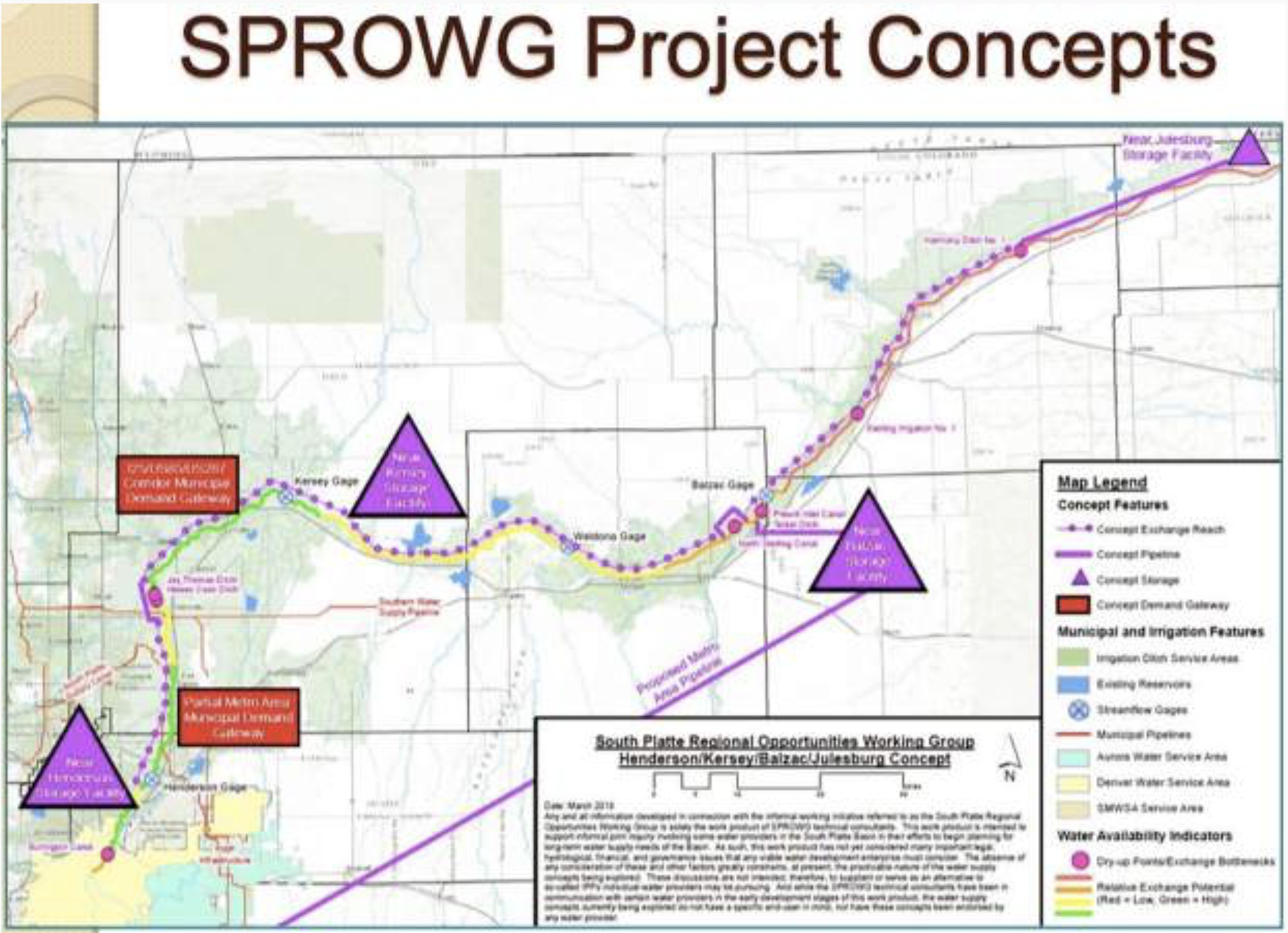
A group called the South Platte Regional Opportunities Working Group, or SPROWG, is proposing to store 175,000 acre-feet of water in a series of reservoirs on the South Platte River, from north of Denver to the Morgan County line. The project also includes a long pipeline to pump water from the river back to the metro area to be cleaned and re-used. Graphic credit: CWCB via Aspen Journalism
In a feasibility study published in March 2020, SPROWG members identified four alternative concepts that could help close the supply gap without diverting additional water from the Western Slope or buying up valuable water rights from local farmers. The study analyzed the potential to store between 215,000 and 409,000 acre-feet of water in various generalized locations between Denver and the Nebraska state line. New storage would rely on available flows not obligated to existing water rights, water that can be reused, or temporary lease agreements with farmers. Stored water would then be used locally, transported through a pipeline for regional use, or exchanged between locations.
The idea, said SPROWG advisory committee member Lisa Darling, was to think regionally instead of by district, to move water where it’s needed at any given time.
“Maybe there was this sort of older water buffalo thinking in the past, but I think we know now that we can’t develop projects in a vacuum anymore,” says Darling, the executive director of the South Metro Water Supply Authority. (Darling also serves as president of Water Education Colorado’s Board of Trustees.) “There’s a holistic system and that’s the prism we have to look through now.”
Dan Luecke, who fought multiple large infrastructure projects across the state, says he’s been encouraged by an increase in innovation where cities and growers are thinking more collaboratively on both storage and use. In an era of constraints, he says, it will take all users — even those across state lines — working together to think about creative and efficient approaches to the storage dilemma.
“If we could get cities and irrigators to agree to some kind of combined management scheme, we might need more storage but we could look at it in a more integrated and efficient context,” Luecke says. “It’s not about storage for this user or that area, it’s about an entire system that’s more flexible.”
Jason Plautz is a journalist based in Denver specializing in environmental policy. His writing has appeared in High Country News, Reveal, HuffPost, National Journal, and Undark, among other outlets.
The ongoing drought across much of the West and above-average temperatures have water quality managers like [Chad] Rudow concerned.
“We had a below-average snowpack, and that snow melted off quicker than usual,” Rudow said. “The double whammy that we got is we went into the year with below-average soil moisture levels.”
When the snow did melt, a lot of that moisture went toward replenishing depleted soil and did not make it back into the rivers, necessarily.
Tanner Shelp, an employee at Roaring Fork Anglers, said although trout fishing had been “amazing” so far this summer, he was worried about it being short lived due to warmer water temperatures and the sheer number of people out on the water each day…
Trout can easily die, even if an angler adheres to proper catch-and-release techniques when water temperatures exceed the mid-60s…
Once river temperatures hit the mid- to upper 60s, the brown, rainbow and other species of trout swimming their waters get stressed, Shelp said…
According to data from the United States Geological Survey, the Roaring Fork River’s water temperature ranged between 57 and 61 degrees Fahrenheit [July 1, 2021]. The Roaring Fork Conservancy via its Instagram account warned that Wednesday night, the Roaring Fork River reached 64 degrees, adding “several stretches along the Colorado River (Upper Colorado and Utah border) have already reached 70 degrees.”
Last year’s Mullen fire burned almost 177,000 acres along the border between Colorado and Wyoming, leaving parts of Medicine Bow-Routt National Forests desolate and burnt. In the absence of normal vegetation, an invasive weed has taken root, and U.S. Forest Officials intend to reverse that.
Cheatgrass is a non-native, invasive grass species in Colorado, characterized by its ability to thrive in areas heavily disturbed by events like construction, fire, and floods. A Colorado State University fact sheet says letting cheatgrass dominate an area could impact wildlife populations and change soil properties. Once introduced to an area, it can produce “more than 10,000 plants per square yard.”
In addition to being a general nuisance and extremely pervasive, cheatgrass is also a major fire risk.
“Though several components can affect flame length and fire spread, a typical cheatgrass fire on flat terrain with wind speeds of 20 miles per hour may generate flame lengths up to eight feet in height; the fire can travel more than four miles per hour,” the CSU fact sheet says.
The plant’s natural life cycle is part of why it presents such a fire hazard. Cheatgrass dies off between April and June, and when that happens, it dries out more quickly than native vegetation, according to the Sage Grouse Initiative. It also has particularly thin stems and leaves, which help it burn more quickly than many native species.
Cheatgrass is an annual invasive plant that crowds out native plants in sagebrush range. Near Elko, Nevada. Photo credit: The Sagebrush Initiative
The U.S. Forest Service, in partnership with the U.S. Department of Agriculture and the Wyoming Game & Fish Department, has begun treating a 9,200 acre area within the Mullen fire perimeter for cheatgrass, with the hopes of reducing or eradicating its presence.
“It is great to continue collaboration efforts with our partners on controlling invasive species in the footprint of the Mullen Fire. Our past treatments have proven to be successful in managing cheatgrass, which is a huge threat to native ecosystem recovery post wildfire.” said Forest Service specialist Jackie Roaque in a statement.
The Forest Service’s operation will last about two months and primarily take place in Wyoming. Recreationists in Medicine Bow-Routt, particularly along the North Platte River, might be affected by the spraying.
Research suggests wildfires are likely to become larger and more unpredictable because of drier and hotter conditions spurred on by climate change.
We have songs and stories to teach children about the connection between seemingly unrelated things. John Muir put it in perspective: “When you tug at one thing in nature, you find it hitched to everything else.”
My “ah-ha!” moment happened at a presentation I attended a few years ago. A slide on the screen showed two rows of fish: on the left, smaller fish from a river with an urbanized floodplain, and on the right, fish of the same species and same age from a river with a natural, functioning floodplain. The fish on the right were almost twice the size as the ones on the left.
A healthy riparian corridor includes native trees and minimal disturbance within 100 feet of the streambank. Waccamaw River photo by Charles Slate.
Fish from rivers with healthy floodplains thrive, while those in rivers without a healthy floodplain merely survive.
The connection between thriving fish, healthy rivers, and functioning floodplains? Trees.
Forested watersheds have been shown much higher water quality than their urbanized counterparts. Trees provide a wide range of ecological services. Tree canopy lessens the erosive impact of rain and slows the velocity of stormwater flowing towards the river, as well as floodwaters spilling out onto the floodplain. Trees trap sediments that build the floodplain while the roots stabilize the riverbanks. Trees also provide shade for maintaining water temperature. Fallen leaves, limbs, and branches support the food web by providing food and habitat for the bugs that are in turn food for fish. Clean, cool water with more food equals bigger fish. Therefore, fish grow on trees.
The connection between fish and trees and rivers is now poised to emerge in our urban areas.
Many cities, from large to small, are recognizing the benefits of reestablishing the physical and emotional linkage between the river, trees and the community. For instance, San Antonio has its iconic River Walk, Chicago has just completed its riverfront, Washington DC has its Southwest Waterfront neighborhood, and Pittsburgh has reconnected neighborhoods to its three rivers via a network of urban trails. Furthermore, Hartford, Nashville, Providence, Denver, and Detroit all offer events on their downtown riverfronts that draw thousands, and Cincinnati, Columbus, Owensboro and many more are rediscovering their community-to-river reconnection. But when you look at images of these urban riverfronts, you notice they all have one thing in common: a lot of hardscape. Hard engineered solutions are meant to reduce maintenance and accommodate maximum access.
The trend in revitalizing urban riverfronts is a giant step forward, but our urban riverfronts also need soft green edges. They need the green space and trees that humans and fish, and all living things, require to thrive. It isn’t possible or desirable to return our urban rivers to forested watersheds, but we can reintroduce trees to our river corridors provide while also adding value to our urban communities.
Healthy for fish, healthy for people. Give trees to fish, and we’re also giving them to ourselves.
I’ve decided there needs to be a song about how fish grow on trees. Remember this folk song?
“…Oh, the limb on the tree,
And the tree in a hole
And the hole in the ground
And the green grass grew all around, all around
And the green grass grew all around…”
Let’s add “…and the green trees grew all around, all around…and big fish in the river are found.”
FromThe Associated Press (Seth Borenstein) via US News & World Report:
An Associated Press analysis shows that the recent heat wave struck places that are warming up faster than other parts of the United States.
As outlandish as the killer heat wave that struck the Pacific Northwest was, it fits into a decades-long pattern of uneven summer warming across the United States.
The West is getting roasted by hotter summer days while the East Coast is getting swamped by hotter and stickier summer nights, an analysis of decades of U.S. summer weather data by The Associated Press shows.
State-by-state average temperature trends from 1990 to 2020 show America’s summer swelter is increasing more in some of the places that just got baked with extreme heat over the past week: California, Nevada, New Mexico, Arizona, Utah, Oregon and Colorado.
The West is the fastest-warming region in the country during June, July and August, up 3 degrees on average since 1990. The Northwest has warmed nearly twice as much in the past 30 years as it has in the Southeast.
That includes Portland, Oregon which set a record 116-degree high that was 3 degrees warmer than temperatures ever recorded in Oklahoma City or Dallas-Fort Worth.
Although much of the primary cause of the past week’s extreme heat was an unusual but natural weather condition, scientists see the fingerprint of human-caused climate change, citing altered weather patterns that park heat in different places for longer periods…
Climate change is altering and weakening the jet stream, narrow bands of wind that circle the Earth flowing west to east. Those changes allow key weather-producing patterns of high and low pressure to stall in place. High pressure is stalling more often in the West in summer, said Pennsylvania State University climate scientist Michael Mann. High pressure brings hot and dry weather that, when stalled, can create what are known as heat domes. Low pressure brings wet weather.
Another factor is higher water temperatures in the Pacific Ocean that also generate more so-called high-pressure ridges the West, said Gerald Meehl, a National Center for Atmospheric Research scientist who studies heat waves.
These patterns are showing up so often that their effects can be seen in long-term data. The U.S. Northwest, western Canada and Siberia, which also just saw a stunning heat wave, are among Earth’s fastest warming land areas during summer since 1990, Cohen said…
The Midwest is warming slower during the summer than either coast. That’s because stalled low pressure areas often drive cooler air into the Great Lakes region, said North Illinois University climate scientist Victor Gensini.
Water explains the big difference between western and eastern heat trends, scientists said.
“In western states where drought has been expanding and intensifying during the past decade, soil moisture has been declining. Dry soil heats up faster than moist soil during the day because all the solar energy goes into heating rather than into evaporating moisture,” said Jennifer Francis, a climate scientist at the Woodwell Climate Research Center. “Dry soil also cools off faster at night.”
That’s partly why the West, which is getting drier by the decade and is mired in a 20-year megadrought, is seeing those crazy triple digit daytime temperatures.
The East is getting wetter by the decade, NOAA records show, and the East Coast is seeing its biggest warming increase at night. The overnight lows in New Jersey and Delaware have warmed 3 degrees since 1990, the biggest increases in the nation.
Water vapor is a greenhouse gas, Francis explained, “So at night it traps more of the heat.”
Kathie Dello, North Carolina’s state climatologist, attributes the trends to human-caused warming. “There’s no other explanation,” she said.
Wildfires exploded in the record-hot air over southern British Columbia on Wednesday, June 30, producing several massive fire-generated thunderstorms. The ‘pyrocu’ spit out lightning and cast the massive evening shadows seen in this satellite image from 0210Z Thursday, July 1, 2021 (7:10 pm PDT Wednesday). Climate scientist Daniel Swain called the event “a literal firestorm.” (Image credit: RAMMB/CIRA/CSU)
FromYale Climate Connections (Bob Henson and Jeff Masters):
Hundreds of North Americans – and perhaps many more yet to be tallied – have died of heat-related illness over the past week after a mind-boggling heat wave struck the U.S. Pacific Northwest U.S. and far southwest Canada. It’s virtually certain to be the deadliest weather event on record for the region. The unprecedented death toll is the result of a heat onslaught more intense by some measures than anything in global records, yet very much in line with the expected impacts of a human-warmed climate.
The poster community of this horrific episode has to be Lytton, British Columbia. The town broke Canada’s longstanding all-time national high temperature of 45 degrees Celsius (113 degrees Fahrenheit) with a high of 46.6°C (116°F) on Sunday, June 27. The next day brought 47.9°C (118.2°F), and Tuesday a stunning 49.6°C (121°F).
The intense heat flash-dried the rugged, forested landscape, and wildfires mushroomed across the area on Wednesday, June 30. By evening, the entire town of Lytton was under mandatory evacuation orders, and Mayor Jan Polderman told CBC News that “the whole town is on fire.” Most homes in Lytton have been destroyed, according to provincial authorities.
Lytton is home to the Lytton First Nation, a Nlaka'pamux band. In Canada and beyond, Indigenous people are disproportionately affected by climate impacts and Indigenous knowledge has much to contribute to climate solutions. https://t.co/Pgn8Xucvxz
The lighting from the dry thunderstorms (pyrocumulonimbus) that developed was so intense that over 700,000 intracloud and cloud-to-ground lightning flashes were recorded in 15 hours, including more than 100,000 cloud-to-ground strikes. That’s about 5% of the total number of lightning flashes Canada typically sees in an entire year (see Tweet below).
The fires have generated huge clouds of choking smoke that put air quality in the red “Unhealthy” range in Kamloops, British Columbia, on Thursday.
I've watched a lot of wildfire-associated pyroconvective events during the satellite era, and I think this might be the singularly most extreme I've ever seen. This is a literal firestorm, producing *thousands* of lightning strikes and almost certainly countless new fires. #BCwxhttps://t.co/jS0DrJldR3
This heat disaster’s tragic nature is evident even in initial data. British Columbia has reported 486 sudden deaths, three times more than usual for this time of year. At least 16 people died of heat-related causes in Seattle. And in Multnomah County, Oregon, which includes Portland, the county medical examiner announced in a poignant news release on Wednesday that 45 residents had died as a result of excessive heat.
“The preliminary cause of death is hyperthermia,” the county said. “The people who died ranged in age from 44 to 97 and include 17 women and 27 men … Many had underlying health conditions. Many of those who died were found alone, without air conditioning or a fan.”
Similarly, many of those who died in British Columbia were found alone in unventilated homes, according to the chief coroner of British Columbia, Lisa Lapointe, as cited by BBC.
The eventual death toll from this heat wave is likely to be much higher than current estimates, according to Kristie Ebi, a professor of global health at the University of Washington. Death certificates need to be gathered and analyzed from multiple areas, and the underlying and contributing causes of death ascertained (a challenge in itself). So it can take months to fully calculate the number of “excess deaths” related to a regional heat wave, as explained in detail in a YCC post last December.
“Those numbers are only going to go up,” Ebi said. Focusing only on factors such as heat stroke “gives you a massive underestimate of the overall [death toll].” Many heat wave deaths are triggered by respiratory and cardiovascular failures often under-recognized as being related to the torrid, often-polluted air of a heat wave.
If there’s one thing Ebi wants to avoid, it’s thinking of this catastrophic heat wave as the “new normal,” which she calls “really misleading” as it actually underestimates the gravity of the situation. “It implies we’re going from one state to another state. We’re in a period when there’s going to be ongoing change for decades.
“The new normal is not the current temperature. The new normal is the constant change.”
Otherworldly heat records
Never in the century-plus history of world weather observation have so many all-time heat records fallen by such a large margin than in the past week’s historic heat wave in western North America. The only heat wave that compares is the great Dust Bowl heat wave of July 1936 in the U.S. Midwest and south-central Canada. But even that cannot compare to what happened in the Northwest U.S. and western Canada over the past week.
“This is the most anomalous regional extreme heat event to occur anywhere on Earth since temperature records began. Nothing can compare,” said weather historian Christopher Burt, author of the book “Extreme Weather.”
Pointing to Lytton, Canada, he added, “There has never been a national heat record in a country with an extensive period of record and a multitude of observation sites that was beaten by 7°F to 8°F.”
International weather records researcher Maximiliano Herrera (@extremetemps) agrees. “What we are seeing now is totally unprecedented worldwide,” said Herrera, who tweeted on June 30, “It’s an endless waterfall of records being smashed.”
Some examples of the extremity of this event, based on preliminary data:
Portland, Oregon, broke its longstanding all-time record high (107°F from 1965 and 1981) on three days in a row – a stunning feat for any all-time record – with highs of 108°F on Saturday, June 26; 112°F on Sunday; and 116°F on Monday. That 116°F is one degree higher than the average daily high on June 28 at Death Valley, California.
• Quillayute, Washington, broke its official all-time high by a truly astonishing 11°F, after hitting 110°F on Monday (old record: 99°F on August 9, 1981). Quillayute is located near the lush Hoh Rain Forest on the Olympic Peninsula, just three miles from the Pacific Ocean, and receives an average of 100 inches of precipitation per year.
• Jasper, Alberta, broke its all-time high of 36.7°C (98.1°F) on four days in a row, June 27-30, with highs of 37.3°C, 39.0°C, 40.3°C, and 41.1°C (99.1°F, 102.2°F, 104.5°F, and 106°F).
• All-time state highs were tied in Washington (118°F at Dallesport) and set in Oregon (118°F at Hermiston, beating the reliable record of 117°F), and provincial highs were smashed in British Columbia (49.6°C at Lytton, beating 39.1°C) and Northwest Territories (39.9°C at Fort Smith, beating 31.7°C).
According to Herrera, more all-time heat records have been broken by at least 5°C (9°F) in the past week’s heat wave than in the previous 84-plus years of world weather recordkeeping, going back to July 1936. It’s worth noting that the record North American heat of the 1930s, including 1936, was largely connected to the Dust Bowl, in which the effects of a multiyear drought were amplified by over-plowed, denuded soil across the Great Plains – an example of human-induced climate change itself, albeit temporary.
Preliminary data from NOAA’s U.S. Records website shows that 55 U.S. stations had the highest temperatures in their history in the week ending June 28. More than 400 daily record highs were set. Over the past year, the nation has experienced about 38,000 daily record highs versus about 18,500 record lows, consistent with the 2:1 ratio of hot to cold records set in recent years.
What next?
The hellish heat dome that developed over the hardest-hit areas in this heat wave has now weakened and shifted east, though unusually hot conditions remain over a large part of the northern U.S. and western Canada.
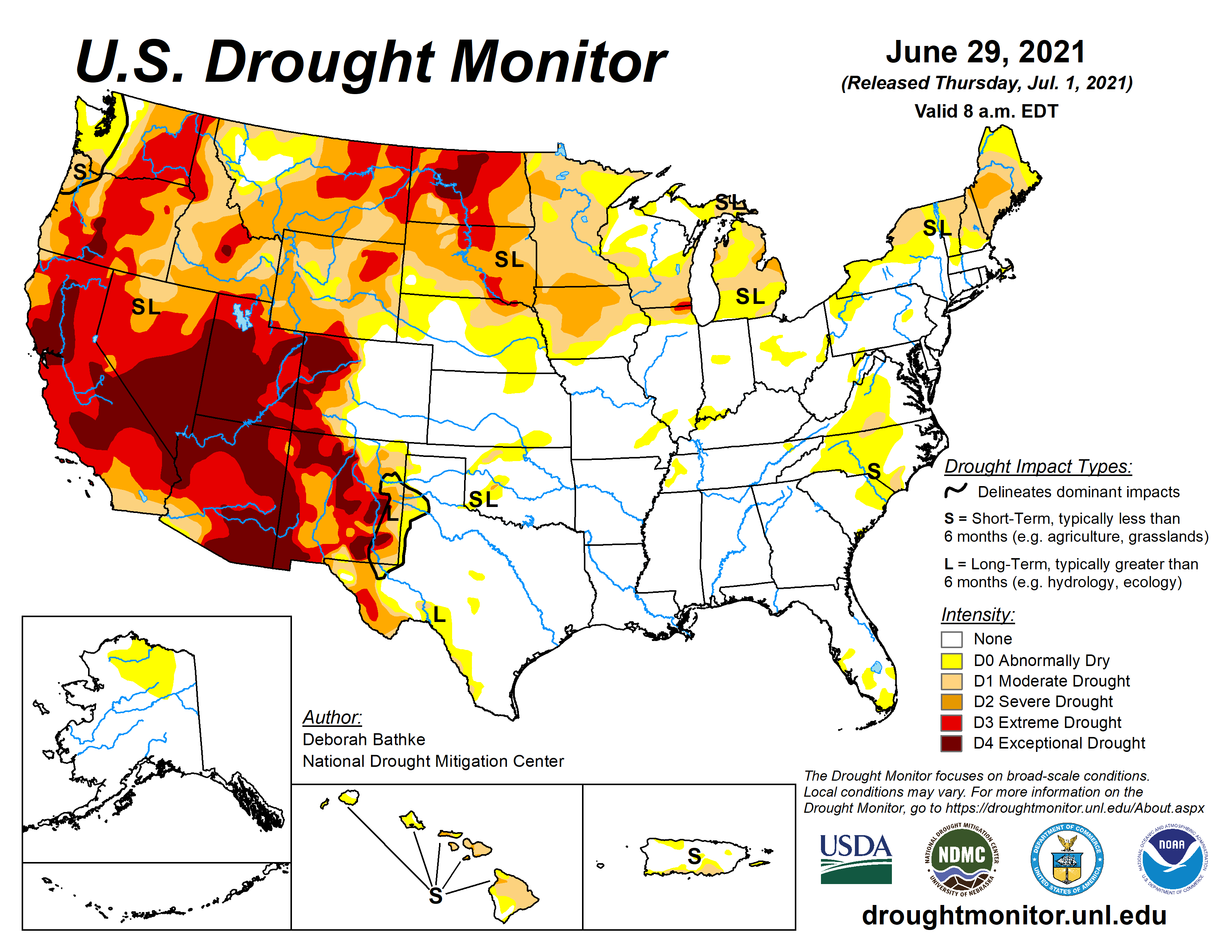
Unrelenting drought has only intensified in recent weeks across the western U.S., where the overall extent of drought is at its highest level since the U.S. Drought Monitor was established in 2000. As of June 29, severe to exceptional drought (levels D2 to D4) covered 81% of the West, the first time on record that index has gone above 80%.
Meanwhile, a downstream buckling of the jet stream has led to an unusually mild, wet week from the Southern Rockies into the Midwest, though nothing close to record-setting on the same level as the heat wave. Oklahoma City received nearly 7” of rain in the last week of June, and parts of Detroit saw 6-8” of rain on June 26, triggering widespread high-impact flooding.
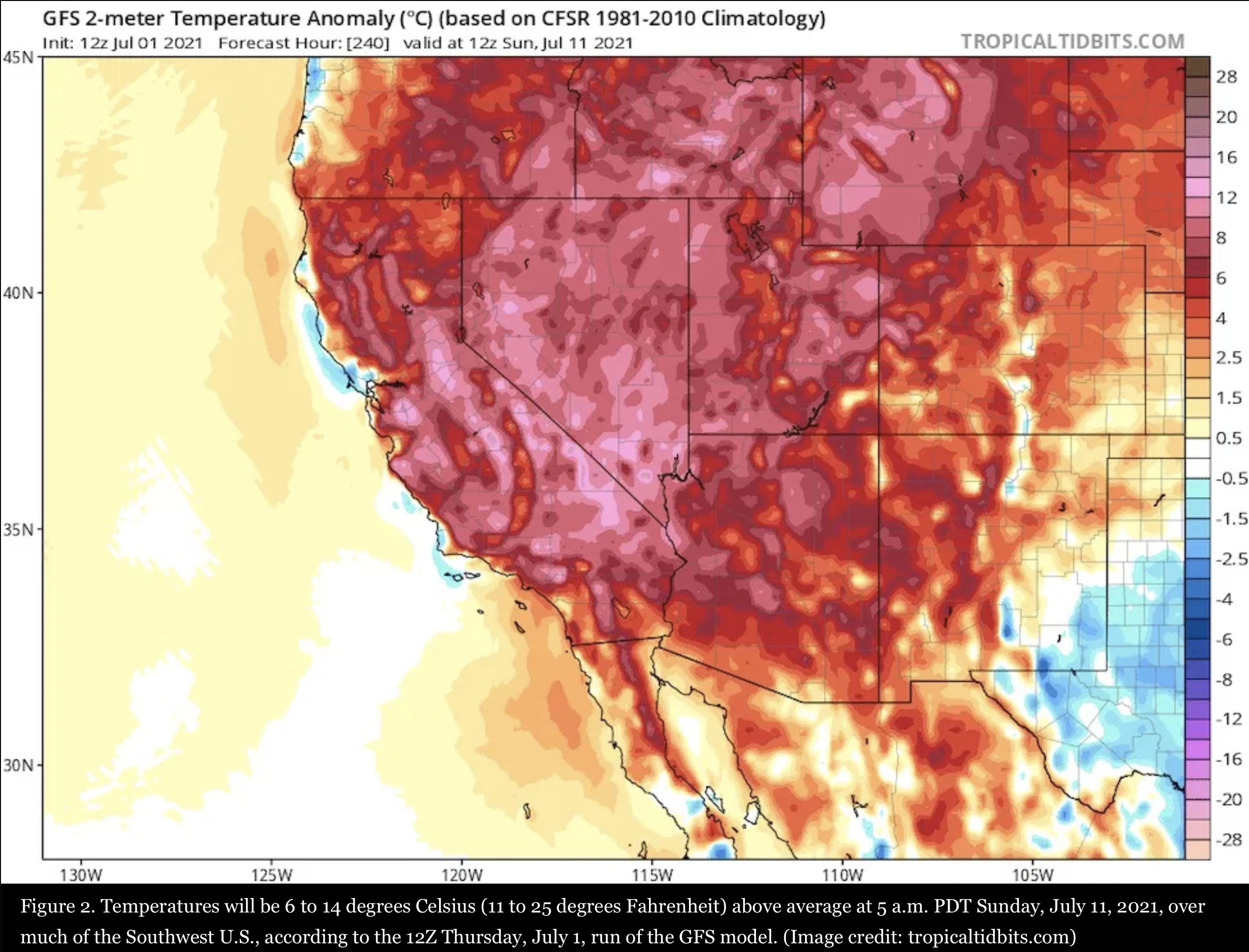
Uh-oh: another extreme high-pressure ridge predicted for the U.S. West
It’s July, the hottest month of the year in the Northern Hemisphere, and extreme ridges of high pressure forming in July have a good chance of setting all-time heat records. Unfortunately, the latest 10-day forecasts from the GFS and European models predict that the western U.S. will have an unusually intense ridge of high pressure capable of overthrowing more all-time U.S. heat records July 10-12.
By one common measure, the 12Z Thursday run of the GFS model is predicting that the heat dome at the center of this upper-level high will be nearly as strong as any ever observed. Warm air expanding at lower levels pushes up the height of the 500-millibar surface, roughly at the midpoint of the atmosphere, vertically. The 500-mb height is predicted by the GFS ensemble model average to exceed 598 decameters over the southwestern U.S. on July 11; the operational version of the model predicted 601 dm. The record-high 500-millibar height at Las Vegas, Nevada, as measured in twice-daily weather-balloon launches (soundings) since 1948, is 602 dm.
Ten-day forecasts of this nature are often inaccurate, so the coming heat wave may fall short of setting all-time records. Nevertheless, with record drought gripping the region, even an average-strength heat wave could boost the odds of significant wildfire activity.