Click on a thumbnail graphic to view a gallery of drought data from the US Drought Monitor.
US Drought Monitor map July 27, 2021.
High Plains Drought Monitor map July 27, 2021.
West Drought Monitor map July 27, 2021.
Colorado Drought Monitor map July 27, 2021.
Click here to go to the US Drought Monitor website. Here’s an excerpt:
This Week’s Drought Summary
A robust Southwestern monsoon circulation delivered drought-easing rainfall but sparked localized flash flooding across large sections of the Four Corners States, as well as the southern Great Basin, but critically dry conditions persisted across northern California and the Northwest. In the driest areas, wildfires—some sparked by lightning—dotted the landscape, with containment of some blazes hampered by high temperatures, low humidity levels, erratic winds, and abundant fuels. Farther east, another round of blistering heat across the northern Plains further stressed rangeland, pastures, and a variety of summer crops. The central and southern Plains also experienced some hot weather, although agricultural impacts were tempered by mostly adequate soil moisture reserves. Meanwhile, mostly dry weather covered the Midwest, continuing a trend that had developed in mid-July. Short-term dryness was not yet a concern in the previously well-watered lower Midwest. However, reproductive corn and soybeans in drier areas of the upper Midwest were subjected to increasing levels of stress, especially as temperatures began to rise. Elsewhere, Southeastern rain—which maintained abundant moisture reserves for pastures and summer crops—primarily fell from the Mississippi Delta to the southern Atlantic Coast…
Drought’s footprint remained rather limited across Kansas, eastern Colorado, and southern Nebraska. Farther north and west, however, worsening drought impacts were observed across much of Wyoming and the Dakotas. According to the U.S. Department of Agriculture, topsoil moisture on July 25 was rated 87% very short to short in North Dakota, along with 82% in South Dakota and 79% in Wyoming. Rangeland and pastures were rated at least 60% very poor to poor in Wyoming and the Dakotas, led by North Dakota at 85%. On July 25, North Dakota was the national leader in oats rated very poor to poor (56%), along with soybeans (41%) and corn (39%). South Dakota led the nation, among major production states, in sorghum rated very poor to poor (31%). Nationally, the U.S. spring wheat crop was rated just 9% good to excellent and 66% very poor to poor on July 25, the lowest overall condition at this time of year since July 25, 1988, when the crop was categorized as 4% good to excellent and 72% very poor to poor. Harvest was underway for drought-ravaged crops on the High Plains; 3% of the spring wheat had been cut by July 25. Periodic extreme heat on the northern Plains has greatly aggravated drought impacts. During the most recent heat wave, high temperatures in South Dakota on July 27 soared to 108°F in Pierre and 107°F in Rapid City. In the latter location, that represented the highest temperature since August 29, 2012…
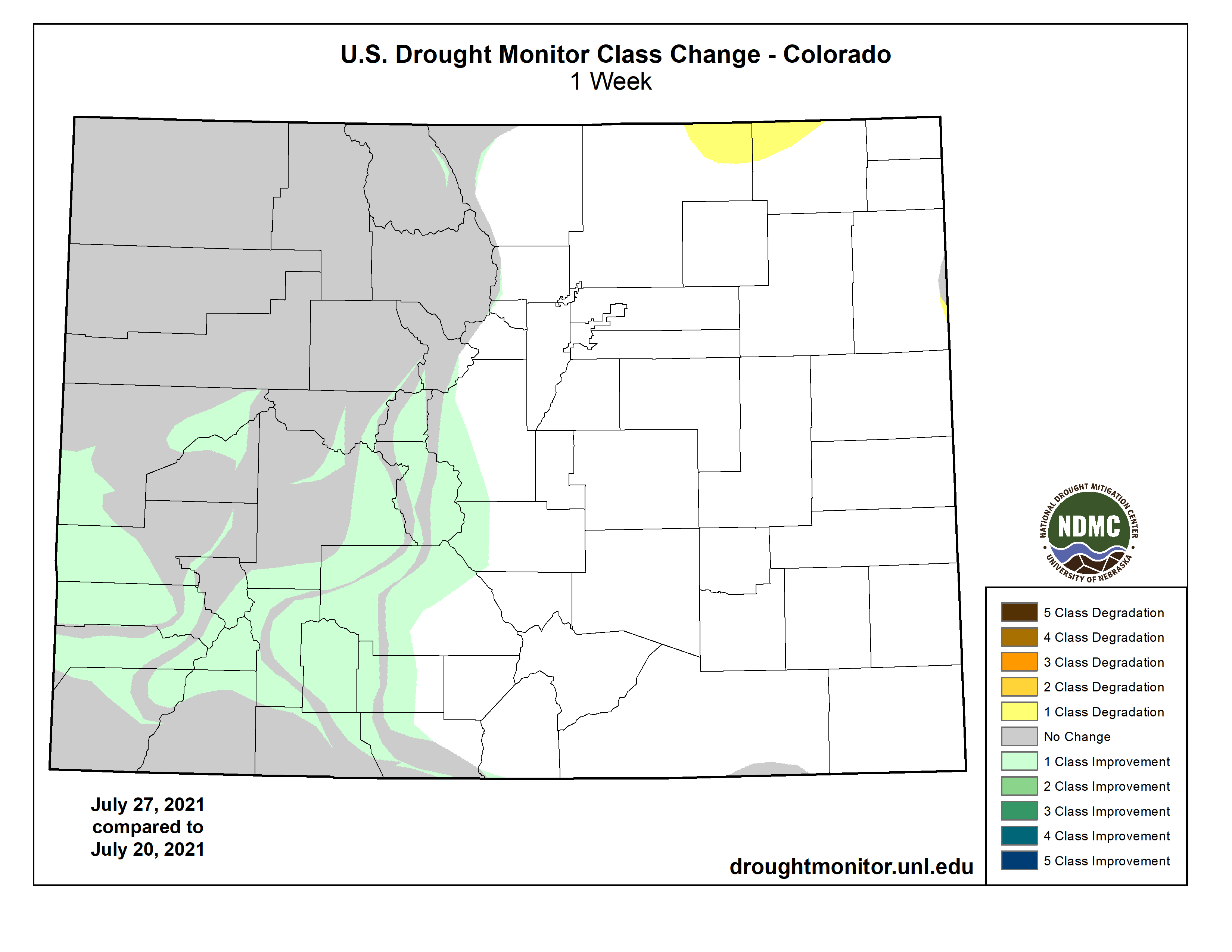
Colorado Drought Monitor one week change map ending July 27, 2021.
Further expansion of moderate to exceptional drought (D1 to D4) was introduced in parts of California and the Northwest, as agricultural, wildfire, and water-supply impacts continued to mount. Oregon’s third-largest wildfire in modern history, the Bootleg Fire, has burned more than 410,000 acres of timber and brush, but was more than 50% contained. California’s largest active blaze, the Dixie Fire, has scorched nearly 220,000 acres only about 15 miles northeast of the town of Paradise, which was devastated by the Camp Fire in 2018. Washington continued to lead the country in several drought-related agricultural categories, according to the U.S. Department of Agriculture, including topsoil moisture rated very short to short (99% on July 25), as well as very poor to poor ratings for rangeland and pastures (97%) and spring wheat (88%). In addition to Washington, at least two-thirds of the rangeland and pastures were rated very poor to poor on July 25 in Montana (91%), Arizona (82%), Oregon (80%), and Utah (69%). Montana rivaled Washington for agricultural drought severity, with topsoil moisture rated 97% very short to short and a nation-leading 70% of its barley rated very poor to poor. Farther south, however, an active monsoon circulation delivered drought relief in the form of diurnal showers and thunderstorms, some heavy. Up to one category of improvement was introduced in parts of Arizona, New Mexico, southwestern Colorado, and southern sections of Utah and Nevada. In Arizona, Tucson received more rain in 6 days (4.20 inches fell from July 20-25) than during all of 2020, when annual precipitation of 4.17 inches was the lowest on record. Despite the positive effect of monsoonal showers on surface conditions (e.g. improved vegetation health, topsoil moisture, and streamflow), serious long-term, underlying drought persisted, with obvious impacts on groundwater and reservoirs. The surface elevation of Lake Mead, on the Colorado River behind Hoover Dam, fell to a new record low—1,067.59 feet above sea level—on July 23. In Utah, the surface elevation of the Great Salt Lake fell below 4,191.4 feet in late July, breaking the previous record low set in 1963…
Arkansas, Louisiana, and Mississippi remained free of dryness and drought, while only small patches of abnormal dryness (D0) and moderate drought (D1) were noted in Oklahoma, Texas, and Tennessee. Most Southern crops continued to fare well amid plentiful rainfall and relatively mild temperatures. On July 25, three-quarters (75%) of the nation’s peanuts were rated in good to excellent condition, according to the U.S. Department of Agriculture, along with 73% of the rice and 61% of the cotton…
Looking Ahead
Cooler air will overspread the northern Plains and upper Midwest, though many drought-affected areas will remain in need of moisture. Large sections of the central and southern Plains will also remain mostly dry, accompanied by some of the hottest weather of the summer. Farther east, periodic showers and thunderstorms will affect the Great Lakes and Northeastern States. Meanwhile, hot, humid weather will linger into the weekend across the South, where an approaching cold front will generate showers and thunderstorms. Elsewhere, the Southwestern monsoon circulation will remain active, with beneficial showers dampening interior sections of the western United States as far north as Wyoming and southern Idaho.
The NWS 6- to 10-day outlook for August 3 – 7 calls for the likelihood of above-normal temperatures in Alaska, southern Florida and from the Pacific Coast to the northern Plains and upper Midwest, while cooler-than-normal conditions will cover much of the southeastern half of the country. Meanwhile, near- or below-normal rainfall across most of the United States should contrast with wetter-than-normal weather in a few areas, including western Alaska, the southern Atlantic region, the southern Plains, and the Northwest.
US Drought Monitor one week change map ending July 27, 2021
Wellington faces a Catch-22, caught between its desire for growth and the water issues that threaten to slow it to a crawl.
The town of about 12,000 has plenty of water — the lifeblood of any community — to serve thousands of new homes. But the cost of water is rising rapidly and the town currently lacks the capacity to store it, treat it or flush it. Both its water and wastewater treatment plants are overextended.
Expansions are underway but still three years away from completion.
It’s not a new problem for Wellington, which earlier this year raised water rates to pay for an expansion of its water and wastewater treatment plants, imposed water restrictions and limited new residential building permits to about 100 per year until the expansions are complete.
The very measures it’s taking to create that infrastructure have raised water rates to the highest in Northern Colorado, which could, in turn, adversely affect growth as builders consider their options.
It’s a fragile balance that’s frustrating residents who are now paying about double what they were two years ago and has the town asking for patience.
Residential water and sewer taps, the largest slice of new development impact fees collected when a building permit is issued, went from $5,500 to $7,500 for a typical home tap and sewer taps increased from $7,500 to $9,700.
Those fees, which also pay for things like parks, streets, water and sewer lines, are typically passed on to the homebuyer or business, which is one reason the cost of homes is going up in Wellington…
Continuing to increase impact fees while at the same time limiting the number of residential permits to stay within treatment capacities “could reach a point where developers or buildings are unwilling to build in Wellington,” the town wrote on its website, “and could result in a slowdown or stop to new development, shifting the cost of paying for improvements onto existing residents…
When treatment plant expansions are done in 2024, they will be able to support Wellington’s expected growth for about 20 years, when the population is expected to double to about 24,000, Town Administrator Patti Garcia said.
Plant expansions won’t bring rate relief, however, she said. Base water rates were raised $31 — to $66 a month — in January to pay the debt service on the water treatment plant. To get the loan, the town had to prove it could pay it back, Garcia said…
For comparison, Fort Collins’ base water rate is $18.30 with a charge of $2.83 per 1,000 gallons of water up to 7,000 gallons. Like Wellington, it has tiered rates that go up the more water used. The charge for water over 13,000 gallons is $3.75 per 1,000 gallons.
That means a Wellington resident using the average 7,000 gallons per month would pay $97.92 per month compared to $38.11 for the same amount of water through Fort Collins Utilities…
It won’t help rates, but finishing the treatment plant expansions should ease water restrictions and lift the moratorium on building permits…
Wellington is served by the North Poudre Irrigation Co., whose share costs have risen 40% since 2018, when the town wrote in its resolution to increase rates. That resolution passed in August 2020. NPIC water currently sells for $200,000 or more per share.
In response to past increases and hedging its bets against future increases, Wellington increased its raw water rates from $19,285.50 to $67,586 for 0.58 acre feet of water — the amount of water it requires for every developed dwelling unit.
“Once we have capacity in the water treatment plant we will be fine,” Garcia said. “We have plenty of water, the issue is having the capacity to provide it, store it, use it and flush it. We’re looking forward to what 2024 can bring.”
Dusty Hill, the quiet, bearded bass player who made up one third of ZZ Top, among the best-selling rock bands of the 1980s, has died at his home in Houston. He was 72.
His bandmates Frank Beard and Billy Gibbons announced the death on Wednesday through Facebook and Instagram. They did not provide a cause or say when he died.
Starting in the early 1970s, ZZ Top racked up dozens of hit records and packed hundreds of arenas a year with their powerful blend of boogie, Southern rock and blues. But the band really took off in the 1980s, when Mr. Gibbons, the lead singer and guitarist, and Mr. Hill grew their signature 20-inch beards and the band released a series of albums that added New Wave synthesizers — often played by Mr. Hill — to their hard-driving guitars, producing MTV-friendly hits like “Legs” and “Sharp-Dressed Man.”
The band paired their grungy sound and innuendo-filled lyrics with a knowing, sometimes comic stage act — Mr. Hill and Mr. Gibbons, in matching sunglasses and Stetson hats, would swing their hips in unison, spinning their instruments on mounts attached to their belts. (Despite his name, Mr. Beard, the drummer, sports just a mustache.) Their stage sets might include crushed cars and even livestock.
Though in public Mr. Hill and Mr. Gibbons were often mistaken as twins, their musical styles differed — Mr. Gibbons a showy virtuoso, Mr. Hill a grinding, precise musical mechanic.
Mr. Hill rarely gave interviews, preferring to let Mr. Gibbons speak for the band. And he gladly accepted his supporting role for his bandmate’s masterful lead guitar playing.
“Sometimes you don’t even notice the bass,” he said in a 2016 interview. “I hate that in a way, but I love that in a way. That’s a compliment. That means you’ve filled in everything and it’s right for the song, and you’re not standing out where you don’t need to be.”
Joseph Michael Hill was born in Dallas on May 19, 1949. He started his musical career singing and playing cello, but he switched instruments at 13, when his brother, Rocky, who played guitar, said his band needed a bassist. One day Dusty came home to find a bass on his bed; that night, he joined Rocky onstage at a Dallas beer joint.
“I started playing that night by putting my finger on the fret, and when the time came to change, my brother would hit me on the shoulder,” he said in a 2012 interview.
In 1969, Dusty was living in Houston and working with the blues singer Lightnin’ Hopkins when Mr. Beard, a friend from high school, suggested that he audition for an open spot in a trio, called ZZ Top, recently founded by Mr. Gibbons. They played their first show together in February 1970.
The band’s humor was evident from the start: They named their first album “ZZ Top’s First Album.” Real success came in 1973 with their third release, “Tres Hombres,” which cracked the Billboard top 10. That same year they opened for the Rolling Stones in Hawaii.
Many of their early songs leaned heavily on sexual innuendo, though sometimes they set the innuendo aside completely. “La Grange,” their big hit on “Tres Hombres,” was about a bordello.
In 1976, after a string of hit albums and nearly seven years of constant touring, the band took a three-year hiatus. Mr. Hill returned to Dallas, where he worked at the airport and tried to avoid being identified by fans.
“I had a short beard, regular length, and if you take off the hat and shades and wear work clothes and put ‘Joe’ on my work shirt, people are not expecting to see you,” he said in a 2019 interview. “Now, a couple of times, a couple of people did ask me, and I just lied, and I said: ‘No! Do you think I’d be sitting here?’”
The band reunited in 1979 to release “Degüello,” their first album to go platinum, and the first time Mr. Gibbons and Mr. Hill grew out their beards. It was also the first sign that they were going beyond their Texas roots by adding a New Wave flavor to their sound, with Mr. Hill also playing keyboard.
They achieved superstar status in 1983 with “Eliminator,” which included hit singles like “Legs,” “Sharp Dressed Man” and “Give Me All Your Lovin.’” It sold 10 million copies and stayed on the Billboard charts for 183 weeks…
The band’s success continued through the 1980s, and while later albums — in which they returned to their Texan blues roots — didn’t climb the charts, the trio still packed stadiums. And despite their raunchy stylings, they began to draw grudging respect from critics, who often singled out Mr. Hill’s subtly masterful bass playing.
“My sound is big, heavy and a bit distorted because it has to overlap the guitar,” he said in a 2000 interview. “Someone once asked me to describe my tone, and I said it was like farting in a trash can. What I meant is it’s raw, but you’ve got to have the tone in there.”
[…]
Mr. Hill married his longtime girlfriend, Charleen McCrory, an actress, in 2002. He also had a daughter. Information on survivors was not immediately available.
Creeks, rivers and lakes that are fed by melting snow across the U.S. West are already running low as of mid-July 2021, much to the worry of farmers, biologists and snow hydrologists like me. This is not surprising in California, where snow levels over the previous winter were well below normal. But it is also true across Colorado and the Rocky Mountains, which in general received a normal amount of snow. You’d think if there was normal amount of snow you’d have plenty of water downstream, right?
Of course, a dry winter will result in meager flows in spring and summer. But there are other reasons snow from the mountains won’t reach a river below. One growing area of research is exploring how droughts can lead to chronically dry soil that sucks up more water than normal. This water also refills the groundwater below.
But another less studied way moisture can be lost is by evaporating straight into the atmosphere. Just as the amount of snow varies each year, so too does the loss of water to the air. Under the right conditions, more snow can disappear into the air than melts into rivers. But how snowfall and loss of moisture into the air itself relate to water levels in rivers and lakes is an important and not well understood part of the water cycle, particularly in drought years.
Under most conditions, frozen carbon dioxide, otherwise known as dry ice, doesn’t melt, but jumps straight from a solid to a gas when it is warmed up.
Losing moisture to the air
There are two ways moisture can be lost to the atmosphere before it reaches a creek or river.
The first is through evaporation. When water absorbs enough energy from the Sun, the water molecules will change into a gas called water vapor. This floating water vapor is then stored in the air. Most of this evaporation happens from the surface of lakes, from water in the soil or as snow melts and the water flows over rocks or other surfaces.
Another way moisture can be lost to the atmosphere is one you might be less familiar with: sublimation. Sublimation is when a solid turns directly into a gas – think of dry ice. The same can happen to water when snow or ice turns directly into water vapor. When the air is colder than freezing, sublimation happens when molecules of ice and snow absorb so much energy that they skip the liquid form and jump straight to a gas.
A number of atmospheric conditions can lead to increased evaporation and sublimation and eventually, less water making it to creeks and streams. Dry air can absorb more moisture than moist air and pull more moisture from the ground into the atmosphere. High winds can also blow moisture into the air and away from the area where it initially fell. And finally, the warmer air is and more Sun that shines, the more energy is available for snow or water to change to vapor. When you get combinations of these factors – like warm, dry winds in the Rockies called Chinook winds – evaporation and sublimation can happen quite fast. On a dry, windy day, up to around two inches of snow can sublimate into the atmosphere. That translates to about one swimming pool of water for each football field-sized area of snow.
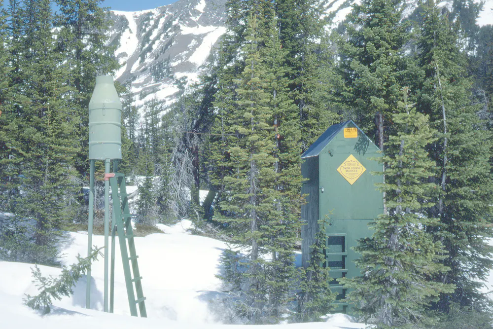
Snow survey sites, like the one seen here in Montana, can help scientists measure snowpack, but most sublimation happens above the treeline, a zone for which there is little data. USDA NRCS Montana/WikimediaCommons
Sublimation is mysterious
It is relatively easy to measure how much water is flowing through a river or in a lake. And using satellites and snow surveys, hydrologists can get decent estimates of how much snow is on a mountain range. Measuring evaporation, and especially sublimation, is much harder to do.
When scientists have been able to measure and estimate sublimation, they have measured moisture losses that range from a few percent to more than half of the total snowfall, depending on the climate and where you are. And even in one spot, sublimation can vary a lot year to year depending on snow and weather.
When moisture is lost into the atmosphere, it will fall to the surface as rain or snow eventually. But that could be on the other side of the Earth and is not helpful to drought-stricken areas.
Important knowledge
It is hard to say how important loss of moisture to the atmosphere is to the total water cycle in any given mountain range. Automated snow monitoring systems – especially at high elevations above the treeline – can help researchers better understand what is happening to the snow and the conditions that cause losses to the atmosphere.
The amount of water in rivers – and when that water appears – influences agriculture, ecosystems and how people live. When there is a water shortage, problems occur. With climate change leading to more droughts and variable weather, filling a knowledge gap of the water cycle like the one around sublimation is important.
Public hearings set for August and September are canceled
Last September (2020), Denver Water submitted an Areas and Activities of State Interest (1041) application to Boulder County Community Planning & Permitting (CPP) for its Gross Reservoir Expansion project.
Since that time, CPP requested additional information from Denver Water. On June 29, 2021, the CPP Director acknowledged Denver Water’s intent to not provide additional requested information, and determined the 1041 review will move to public hearings.
Denver Water filed a lawsuit against the county in July 2021. The lawsuit alleges that the county does not have the authority to regulate the project because the project requires a permit from the Federal Energy Regulatory Commission. Because of the lawsuit, on July 26, Denver Water’s attorney requested that the CPP Director place the 1041 application on hold, and CPP Director Dale Case granted the request the next day, July 27.
Consequently, public hearings that were set for August and September have been canceled.
“It makes sense to have the court resolve the legal issues about whether Boulder County can proceed before conducting hearings on the 1041 review,” said Case. “We have already devoted significant time and resources to processing Denver Water’s application, and it would take even more county resources to proceed with public hearings.”
The Areas and Activities of State Interest (1041) application for the expansion of Gross Reservoir is a request to store an additional 77,000 acre-feet total of water, which includes increasing the dam height by approximately 131 feet, the dam length by approximately 790 feet, and the spillway elevation by approximately 126 feet; quarry operations to obtain aggregate needed for construction; construction of a temporary concrete batch/production plant and an aggregate processing plant; permanent road improvements to Gross Dam Road from State Highway 72 to Gross Reservoir; temporary road improvements to FS359 (Winiger Ridge Road) and FS97 (Lazy Z Road); and the relocation of the Miramonte Multi-Use Trail.
At Hays Market, gallon jugs of drinking water have been flying off the shelves for the better part of two weeks. According to grocery manager Daniel Gehring, the store has gone from ordering several cases of water to palates of it, and not because of the hot weather.
“The town’s water is smelly, funny and has a dirt taste to it, so people are buying the heck out of the gallon water,” Gehring said.
For the grocery store, the business is a plus, but around town, folks like David Salls are concerned. He’s recently turned to filtering all of the water anyone in the family drinks, including his dogs…
Town manager Matt LeCerf says the odor is harmless, and the result of chemical compounds created by algae blooms in the Lone Tree Reservoir, the city’s main water source.
Normally, the water travels into town via a pipeline and drainage ditch, but this year the drainage ditch is not being used because of the nearby Cameron Peak and East Troublesome Fire burn scars…
According to LeCerf, the ditch into town naturally aerates and filters the water more than the pipeline.
“We’re basically in a position where we have to run our water through the reservoirs where we do have that standing water that’s causing some of the taste and odor issues,” LeCerf said.
After hearing similar concerns in the past, the town approved a new $2 million granular activated carbon system earlier this year, which LeCerf said is 90% effective in removing the taste and odor. Construction has been underway for more than two months, and the system is expected to be online Wednesday…
The carbon filtration system isn’t the only improvement in the works for Johnstown. According to LeCerf, the town is also upgrading its water treatment plant and putting special buoys in the reservoir that use ultrasonic wavelengths to help mitigate algae growth.
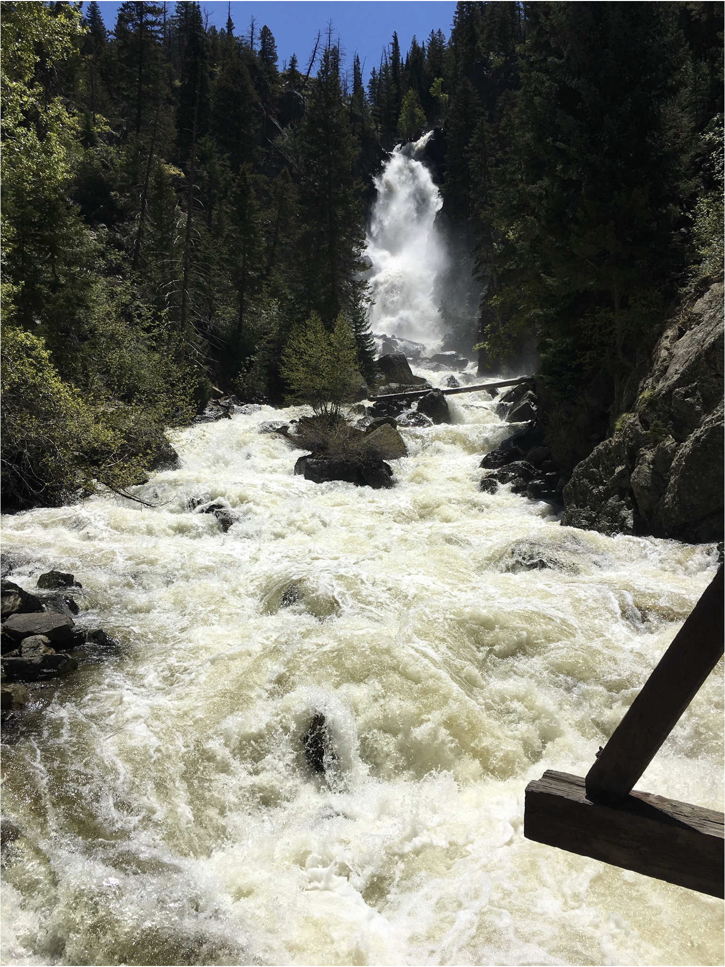
Steamboat Spring’s Fish Creek Falls, photographed the week of June 10, 2019 cascades 280 feet. Colorado’s rivers are running high after an epic winter and wet spring. Photo credit: Amanda Miller via Metropolitan State University at Denver
At the moment, Frank Alfone, manager of the Mount Werner Water and Sanitation District, thinks he supplies Steamboat Springs with some of the best water in Colorado.
The popular ski town relies on Fish Creek for about 93 percent of its normal supply. The postcard Rocky Mountain stream starts as snowmelt before collecting into a narrow canyon, where hikers flock to watch it roar over a 280-foot waterfall.
The water is placid and clear by the time it arrives at the district’s main treatment plant above the city, but Alfone expects that will change sometime soon. After months of drought, Colorado’s two largest active wildfires are burning near Steamboat Springs.
If a future blaze hits the Fish Creek watershed, the charred landscape could erode anytime it rains, possibly turning the city’s primary water source into a turbid soup of ash and debris. The sediment could fill reservoirs, trigger algal blooms or poison water quality with heavy metals…
The Mount Werner Water District and the City of Steamboat Springs are trying to get ahead of similar challenges. Their joint wildfire protection plan, published in 2019, details projects to guard against wildfire in Fish Creek and protect water resources if necessary. It’s the sort of effort experts say other communities should undertake, especially since forests supply 80 percent of U.S. water resources…
Preventing a fire until you can’t
A map helped kickstart Steamboat Springs’ planning effort.
The Colorado State Forest Service updates a detailed look at fire risk across the state every five years. Kelly Romero-Heaney, who managed water resources for Steamboat Springs until earlier this year before leaving for the state, said it was impossible to miss Fish Creek as an area of concern.
“It lit up bright red on the map,” Romero-Heaney said.
The 26-square-mile drainage basin looks like a misshapen funnel from above. Two high-elevation reservoirs collect snowmelt and channel water into tributaries that feed Fish Creek. A narrow canyon carries the water until it reaches Steamboat Springs and meets the Yampa River.
The protection plan, funded with a $50,000 grant from the Colorado Water Conservation Board, modeled the most likely ignition sources for a fire within the watershed. It quickly zeroed in on the Sanctuary Neighborhood, a high-end development north of downtown Steamboat. If a fire started there, it could quickly rocket up the canyon and affect larger parts of the watershed.
The finding helped spur residents to take action…
Carolina Manriquez, a forester with the Colorado State Forest Service in Steamboat Springs who advised the fire protection plan, said those preventative efforts only go so far in areas strained by drought and growing numbers of residents.
“The bottom line is there’s not a lot we can do to minimize the fire risk,” Manriquez said…
Always have a backup
Alfone said fire risk is one reason the Mount Werner Water District developed a backup supply.
In 2018, Mount Werner expanded a second water treatment plant fed by wells along the Yampa River. If the district ever lost access to Fish Creek, he said it would likely have to restrict outdoor water use but could continue to supply indoor water from the auxiliary plant.
The City of Steamboat Springs also owns additional water rights along the Elk River. In the long-term, he said the city could develop the resource into an additional backup…
Over the next two decades, Alfone said the water district also hopes to upgrade its primary treatment plant along Fish Creek to handle water tainted by wildfire runoff. A new intake could help filter out ash and debris and a redesigned filtration system might also improve taste and toxin issues after the smoke clears from the water basin. Each project is outlined in the fire protection plan.
Alfone said the district would likely pay for the improvements through loans, water customer rate hikes or trying to win federal grants.
He is optimistic about the last option. President Biden recently doubled the size of a Federal Emergency Management Agency program to help communities prepare for extreme weather events. The water district likely qualifies after Routt County included the project in its overall disaster-planning efforts.


.jpg#/media/File:Matterhorn_(4448885336).jpg)
.jpg#/media/File:Snow_Survey72_(27281994099).jpg)