On October 14th, the Poudre Flows Project, a collaboration of Colorado Water Trust, the Colorado Water Conservation Board, Cache la Poudre Water Users Association, the cities of Fort Collins, Greeley, and Thornton, Northern Colorado Water Conservancy District, and Colorado Parks and Wildlife, began increasing flows in the Cache la Poudre River. During the week of October 14, Thornton added flows between the mouth of the Poudre River and the confluence with the South Platte.
The Poudre Flows Project aims to reconnect the Cache la Poudre River past numerous frequent dry-up locations between the mouth of the Poudre Canyon and the confluence with the South Platte River while still allowing water rights owners to use their water. Under a temporary plan approved by the State, water provided by the cities of Thornton and/or Greeley can be used in a trial run of the innovative Poudre Flows Project. As conditions allow, the temporary plan allows water provided by Thornton to be used to increase flows by up to 20 cubic feet per second (“cfs”) for up to two weeks this fall and again in the spring. As conditions allow, the plan will also allow water provided by Greeley to be used to increase flows between 3-5 cfs between the months of April to October.
“The Poudre Flows project has brought a cross section of water users and river advocates together to add and protect flows on the Poudre River,” said Emily Hunt, Deputy Utilities Director for the City of Thornton. “Thornton is proud to contribute the first deliveries of water in a trial run of this project and is excited to continue its work with the Colorado Water Trust and the Poudre Flows partners to achieve significant environmental benefits for the Poudre River.”
Fly fishing on the Poudre River west of Fort Collins. Photo credit: Colorado Water Trust
The Poudre Flows Project implements a new mechanism known as a Streamflow Augmentation Plan that was approved by the Colorado legislature to help restore depleted river flows. Generally, an augmentation plan is a tool used by water users to increase flexibility and maximize utilization of water supplies on a stream while still protecting other water users. While augmentation plans are typically used to replace water diverted from the river to meet water use needs, the Poudre Flows Project uses this same tool to meet environmental needs by releasing water to the river and protecting it from diversion by others as it flows downstream.
“The Colorado Water Conservation Board is proud to be a part of this critical effort to protect flows on the Cache La Poudre River,” said Lauren Ris, CWCB Director. “Through our agency’s Instream Flow Program, we are able to ensure that the river maintains its vital flows, supporting both the environment and the communities that depend on it. This collaboration highlights the importance of innovative solutions to protect Colorado’s water for generations to come.”
Historically, environmentalists and recreationalists have been at odds with water users who take water out of the river. The Poudre Flows Project is bringing together those who have previously been in conflict, including municipalities, water conservancy districts, state agencies and agricultural producers. This group will strategically leverage water rights to preserve and improve river flows in times of low flow. The Poudre Flows Project has a pending water court case; but in the meantime, Greeley and Thornton have obtained temporary approvals in October from the Colorado Division of Water Resources, via substitute water supply plans, to use their water rights in the Streamflow Augmentation Plan for one year. This is the first Streamflow Augmentation Plan in the state and could be a model for streamflow improvement in other river basins.
Playing in the Poudre River at the Fort Collins whitewater park. Photo credit: Colorado Water Trust
“Greeley is excited to see the Poudre Flows project going live after many years of regional collaboration, enabling legislation, and investment in this innovative water administration strategy,” said Sean Chambers, Director of Water Utilities for the City of Greeley. “The project will physically enhance the Cache la Poudre river, its aquatic habitat, and the administration of water rights, and Greeley appreciates the Colorado Water Trust’s leadership and project management.”
THE POUDRE FLOWS STORY: For more than a decade, the water community of the Poudre River Basin has been working on an innovative plan to reconnect one of the hardest working rivers in Colorado, the Cache la Poudre River. Since the Colorado gold rush in the mid-1800s, people have diverted water from the Cache la Poudre River for beneficial uses that have helped northeastern Colorado grow into the agricultural and industrial powerhouse it is today.
While the Poudre River flows are high during the spring runoff, there are times throughout the year when the river dries out entirely in places below some water-diversion structures. To combat dry conditions and improve river health, local communities have worked hard over the past decade with the goal of improving and bringing vitality to the Cache la Poudre River. The Poudre Flows Project is a perfect example of those efforts.
The Poudre River during a dry-up period. Photo credit: Colorado Water Trust
Colorado Water Trust, a statewide nonprofit organization with a mission to restore water to Colorado’s rivers, has been one small part of this process. Over a decade ago, Colorado Water Trust had an unorthodox, pioneering idea to reconnect the Poudre River, and the water community of the Poudre River Basin said, “Let’s get it done.” A broad collaboration of water providers, cities, state government, nonprofits, and a collective of farmers have worked tirelessly to make this novel idea a reality and rewater the Poudre River. Finally, this year, the Poudre Flows Project will be put into action through the generous contributions of water by the cities of Greeley and Thornton. This is the first step toward reconnecting the Poudre River both now and for future generations.
”The Poudre Flows Project is such a great example of collaboration and innovative thinking when it comes to water, and it shows a recognition of how important our streams are to us as Coloradans,” said Kate Ryan, Executive Director of Colorado Water Trust. “You have all different types of water users on the Poudre River coming together to take responsibility for the health and vitality of this river and to find ways to protect it for future generations. The success of this project could serve as a blueprint across the state for communities of water users to protect their own rivers and streams in the face of a changing climate.”
Colorado’s water landscape is very complex and the legal structure for this project is innovative. The Poudre Flows Project will provide water right owners a flexible opportunity to add their water to the plan on a temporary or permanent basis. This groundbreaking project has the potential to be replicated in other basins throughout Colorado. Lastly, one of the unique aspects of this project is that it doesn’t change the Poudre River from being the hardest-working river in Colorado. Instead, the Poudre Flows Project provides an avenue for optimal management of river water, to protect people’s livelihoods AND the river itself. The Poudre Flows Project proves that if we work together, we can maintain all that we love about Colorado, from the beauty and thrills of a flowing river to the local food and beer that river water helps provide, and the flourishing neighborhoods that depend on the river’s water in their homes.
“Partnerships are the key ingredient to the success of the Poudre Flows Project,” said Katie Donahue, Director of the City of Fort Collins Natural Areas Department. “Together we are launching a new chapter of river resiliency for our community.”
FUNDERS FOR THIS PROJECT INCLUDE: • Xcel Energy Foundation • City of Fort Collins • City of Greeley • City of Thornton • Northern Water • Gates Family Foundation • Eggleston Family Fund of the Community Foundation of Northern Colorado • New Belgium Brewing Company • Odell Brewing Company • Alan Panebaker Memorial Endowment of the Yampa Valley Community Foundation • Telluray Foundation • Colorado Water Conservation Board
Cache la Poudre River drop structure. Photo credit: Northern Water
Cache la Poudre River. Photo credit: Allen BestFort Collins community members kayak and sit on the shore of the Poudre River during the grand opening of the Poudre River Whitewater Park off of North College and Vine Drive Oct. 12. (Alyssa Uhl | The Collegian)Poudre River whitewater park. Photo credit: Rocky Mountain CollegianFort Collins community members kayak and sit on the shore of the Poudre River during the grand opening of the Poudre River Whitewater Park off of North College and Vine Drive Oct. 12. (Alyssa Uhl | The Collegian)Construction begins on Cache la Poudre River for fish ladder near Watson Lake. Photo credit: Jason Clay/Colorado Parks and WildlifeCache la Poudre tributaries cutthroat stocking event August 2020. Photo credit: Jason Clay via Colorado Parks and WildlifeCache la Poudre River May 2018. Photo credit: Greg Hobbs Ralph Parshall squats next to the flume he designed at the Bellevue Hydrology Lab using water from the Cache la Poudre River. 1946. Photo Credit: Water Resource Archive, Colorado State University, via Legacy Water News.Cache la Poudre River from South Trail via Wikimedia Foundation.Grand River Ditch gaging station. Photo credit Greg Hobbs.Cache la Poudre River
The dry pattern that has been impacting much of the country has continued into this current period. The wettest areas were along the coast in the Pacific Northwest, with some locations recording over 2 inches of rain for the week. Other areas receiving some precipitation were in the Four Corners region, the Midwest and parts of the South, but many of these totals were minimal and did little to impact the drought conditions. The Southern Plains and South were the warmest regions, with departures of 10-12 degrees above normal this week. Almost the entire country was warmer than normal, with only areas of the Northeast and Pacific Northwest having near to slightly below normal temperatures. As the month is ending, many locations will be at or near record dryness across the country. For the Lower 48 states, there has not been this much drought shown on the U.S. Drought Monitor since December 2022. Areas of the Southeast that were impacted by significant precipitation associated with landfalling hurricanes have dried out rapidly, with some locations recording zero precipitation since the hurricanes. Some precipitation development at the end of the current period could help ease conditions into the next week, but that will be determined on the next map…
Dryness again dominated the region with only areas of far southeast Nebraska and northeast Kansas, northeast Wyoming and northwest South Dakota recording any significant precipitation. Coupled with the dryness, temperatures have been unseasonably warm for the region with most all areas 4-8 degrees above normal for the week. Drought expanded and intensified across the region this week with severe and extreme drought expanding over western North Dakota, and moderate drought and abnormally dry conditions expanding over the southeast. Severe and extreme drought expanded over much of western and southern South Dakota and also over western and northern Nebraska. Eastern Nebraska saw both moderate and severe drought expand. In Kansas, severe and extreme drought expanded over the southeast while severe drought expanded over the northeast and western portions of the state. Moderate drought also expanded in western Kansas. In northeast Colorado, moderate drought and abnormally dry conditions expanded, with both moderate and severe drought expanding in southeast Colorado. Southeast Wyoming saw expansion of moderate, severe, and extreme drought while eastern Montana had severe and extreme drought expand to the west…
Colorado Drought Monitor one week change map ending October 29, 2024.
The West was the one region that had substantial precipitation during the week, with rains in the areas of central to northeast Arizona, western Colorado, central to western Wyoming, central Utah, southern Oregon into Idaho and along the coastal areas of the Pacific Northwest. Minimal improvements were made to the abnormally dry conditions along the Oregon coast. Moderate drought improved in northern California and northern Nevada as well as into southern Oregon and Idaho. Abnormally dry conditions disappeared from the rest of southwest Colorado. Severe and extreme drought expanded in northern Colorado into southern Wyoming and severe drought expanded in western Wyoming…
Temperatures were well above normal over the region with areas of north Texas and much of eastern Oklahoma 12-16 degrees above normal for the week. Some very light rains were reported in central Arkansas, but much of the region was dry this week. With the fall warmth and dryness impacting the region, drought intensified and expanded. In Oklahoma, the north-central and eastern portions of the state saw severe and extreme drought expand, with some moderate drought expanding in the east. Widespread degradation took place over much of northern and eastern Texas and into the southern portions of the state, where almost every drought category intensified, most now in severe drought or worse. Moderate and severe drought expanded over portions of West Texas as well. In Arkansas, most of the western portions of the state had degradation this week, now in severe to extreme drought. Moderate drought expanded over southeast Arkansas. Severe drought emerged in northwest and southwest Louisiana, and moderate drought expanded over more of the east and southeastern areas. In Mississippi, moderate and severe drought expanded in the southern half of the state and in a small area of the northeast part of the state. In Tennessee, the short-term dryness allowed slight expansion of the severe and moderate drought in the southern portions of the state. Abnormally dry conditions filled in the rest of northern Tennessee…
Looking Ahead
Over the next 5-7 days, it is anticipated that the dry pattern will break over much of the Plains, Midwest and into the South, with widespread precipitation from north Texas to Wisconsin. The Western portions of the country will also be in a more active pattern, with the coastal areas, the Great Basin, and part of the Rocky Mountains seeing some precipitation. Temperatures will continue to be warmer than normal out in front of the precipitation, with the eastern Midwest, South, and East all anticipated to be warmer than normal, including departures of 13-15 degrees above normal in the Ohio River basin. Cooler- than-normal temperatures will settle in over the West, with departures of 10-13 degrees below normal over much of Nevada.
The 6-10 day outlooks show that the best chance for above-normal temperatures is over the East while much of the West has the best chance for below-normal temperatures centered on the Southwest. The greatest chance for above-normal precipitation is over the southern Rocky Mountains with above normal chances in the Plains and into the Midwest while the greatest chance for below-normal precipitation is over northern California and much of the West.
US Drought Monitor one week change map ending October 29, 2024.
From email from the Gunnison Basin Roudtable (Savannah Nelson):
October 29, 2024
As residents of the Gunnison River Basin, we are privileged to live alongside one of Colorado’s most remarkable natural treasures. The Gunnison River is more than just a waterway—it’s a vital part of our history, our environment, and our daily lives.
The Gunnison River was named after U.S. Army officer and explorer John W. Gunnison, who surveyed the area in the mid-19th century. However, long before Gunnison’s expedition, Indigenous peoples, including the Ute tribes, called this area home. They relied on the river as a source of food, water, and transportation, establishing deep connections with the land and its resources.
The East River Valley, northwest of the historic town of Gothic, home to the Rocky Mountain Biological Laboratory. The mountain with the pointed peak in the distance is Mount Crested Butte. Photo credit: Mark Stone/University of Washington
Our river begins at the confluence of the East River and Taylor River near Almont and flows for about 180 miles until it merges with the Colorado River in Grand Junction. Other tributaries include the North Fork, the Uncompahgre, Cimarron, and Lake Fork. Along its course, the Gunnison carves through some of the most dramatic landscapes in the state, including the striking Black Canyon of the Gunnison—its sheer cliffs dropping over 2,000 feet.
Recreation opportunities are a major piece of local life and tourism; fishing, rafting, swimming, kayaking, and boating are part of the culture surrounding the water.
The Gunnison River is also a lifeline for our local ecosystem. Its waters support a variety of fish species, such as brown and rainbow trout, which are great for anglers, but also contribute to the rich biodiversity of our area.
Sweet corn near Olathe, CO photo via Mark Skalny, The Nature Conservancy.
In addition to the fact that all of us rely on the Gunnison river and its tributaries for drinking water, they play a crucial role in the diverse agricultural activities of the basin. The agricultural uses vary and include a range of cattle and crops, including fruit production and Olathe sweet corn.
Our river is many things: a heritage that we share and a resource we must protect for future generations. To learn more about water and ways to get involved, head to gunnisonriverbasin.org.
On Wednesday and Thursday, October 30 and 31, diversions to the Gunnison Tunnel will be ramped down for the season. Releases from the Aspinall Unit will be adjusted in coordination with the ramp down schedule for Gunnison Tunnel diversions in order to keep Gunnison River flows near the current level of 370 cfs. There could be fluctuations in the river throughout these days until the Gunnison Tunnel is completely shut down.
On Wednesday, October 30, releases from the Aspinall Unit and Gunnison Tunnel diversions will be reduced by 300 cfs. On Thursday, October 31, releases from the Aspinall Unit and Gunnison Tunnel diversions will be reduced by 650 cfs and Tunnel diversions will be ended until next year.
Flows in the lower Gunnison River are currently above the baseflow target of 1050 cfs. River flows are expected to stay above the baseflow target for the foreseeable future.
Pursuant to the Aspinall Unit Operations Record of Decision (ROD), the baseflow target in the lower Gunnison River, as measured at the Whitewater gage, is 1050 cfs for October through December.
Currently, diversions into the Gunnison Tunnel are around 980 cfs and flows in the Gunnison River through the Black Canyon are around 370 cfs. After the shutdown of the Gunnison Tunnel, flows in the Gunnison River through the Black Canyon will still be near 370 cfs. Current flow information is obtained from provisional data that may undergo revision subsequent to review.
This scheduled release change is subject to changes in river flows and weather conditions. For questions or concerns regarding these operations contact Erik Knight at (970) 248-0629 or e-mail at eknight@usbr.gov
East Troublesome Fire. Photo credit: Thomas Cooper
Click the link to read the article on the CIRES website:
October 24, 2024
Fast-growing fires were responsible for nearly 90 percent of fire-related damages despite being relatively rare in the United States between 2001-2020, according to a new CU Boulder-led study. “Fast fires,” which thrust embers into the air ahead of rapidly advancing flames, can ignite homes before emergency responders are able to intervene. The work, published today in Science, shows these fires are getting faster in the Western U.S., increasing the risk for millions of people.
The research highlights a critical gap in hazard preparedness across the U.S. — National-level fire risk assessments do not account for fire speed or provide insight into how people and communities can better prepare for rapid fire growth events.
“We hear a lot about megafires because of their size, but if we want to protect our homes and communities, we really need to appreciate and prepare for how fast fires move,” said Jennifer Balch, CIRES fellow, associate professor of Geography, and the lead author of the study. “Speed matters more for keeping people safe.”
Balch and her colleagues were inspired to look closer at fire speed after the Marshall Fire, which destroyed more than 1,000 homes in Boulder County, Colorado, in December 2021. The fire burned less than 6,100 acres (24.7 square kilometers) but grew quickly due to a combination of dry conditions and high winds. Less than an hour after the fire was reported, it had spread to a town 3 miles (4.8 kilometers) away, eventually prompting the evacuation of tens of thousands of people. In the aftermath, Balch’s team was eager to understand how fire growth rates impact fire risk across the country.
The researchers used satellite data to analyze the growth rates of over 60,000 fires in the contiguous U.S. from 2001-2020. Using a cutting-edge algorithm, which involves applying a set of calculations to each satellite pixel, they identified and recorded the perimeter of each fire for each day it was active.
“Until now, we had scattered information about fire speed,” said Virginia Iglesias, interim director of Earth Lab and co-author of the study. “We harnessed Earth observations and remote sensing data to learn about fire growth across the nation in a systematic manner.”
The team used the fire perimeter maps to calculate the growth rate of each fire as it progressed. They then zoomed in on the fastest fires, which grew more than 4,003 acres (16.2 square kilometers) in a single day, and probed how the highest growth rates changed over time. The analysis revealed a staggering 250 percent increase in the average maximum growth rate of the fastest fires over the last two decades in the Western U.S.
“Fires have gotten faster in the western U.S. in just a couple of decades,” Balch said. “We need to focus on what we can do to prepare communities: hardening homes and making robust evacuation plans.”
To evaluate the impacts of fast fires on people and infrastructure, the researchers compared the growth rates of the fastest fires to information recorded in incident reports about the number of structures damaged or destroyed per fire event. They found that fast fires accounted for 88 percent of the homes destroyed between 2001 and 2020 despite only representing 2.7 percent of fires in the record. Fires that damaged or destroyed more than 100 structures exhibited peak fire growth rates of more than 21,000 acres (85 square kilometers) in a single day.
“These results change how we think about wildfire risk because they position growth rate as a key determinant of a fire’s destructive potential,” Iglesias said.
The work also highlights a critical risk assessment gap. At the national level, wildfire risk models include parameters for area burned, intensity, severity, and probability of occurrence, but they do not incorporate growth rate or other measures of fire speed. Government agencies and insurance companies that use these models are therefore missing vital information about how fires spread, which homeowners could use to better protect themselves and their communities. The authors believe this needs to change.
“When it comes to safeguarding infrastructure and orchestrating efficient evacuations, the speed of a fire’s growth is arguably more critical than its sheer size,” Iglesias said.
West Fork Fire June 20, 2013 photo the Pike Hot Shots Wildfire Today
A photograph archived at the Center for Southwest Research at the University of New Mexico in Albuquerque shows a group of Indigenous students who attended the Ramona Industrial School in Santa Fe. AP Photo/Susan Montoya Bryan
I am a direct descendant of family members that were forced as children to attend either a U.S. government-operated or church-run Indian boarding school. They include my mother, all four of my grandparents and the majority of my great-grandparents.
On Oct. 25, 2024, Joe Biden, the first U.S. president to formally apologize for the policy of sending Native American children to Indian boarding schools, called it one of the most “horrific chapters” in U.S. history and “a mark of shame.” But he did not call it a genocide.
Yet, over the past 10 years, many historians and Indigenous scholars have said that what happened at the Indian boarding schools “meets the definition of genocide.”
From the 19th to 20th century, children were physically removed from their homes and separated from their families and communities, often without the consent of their parents. The purpose of these schools was to strip Native American children of their Indigenous names, languages, religions and cultural practices.
As an Indigenous scholar who studies Indigenous history and the descendant of Indian boarding school survivors, I know about the “horrific” history of Indian boarding schools from both survivors and scholars who contend they were places of genocide.
Was it genocide?
The United Nations defines “genocide” as the “intent to destroy, in whole or in part, a national, ethnical, racial or religious group.” Scholars have researched different cases of genocide of Indigenous peoples in the United States.
Historian Jeffery Ostler, in his 2019 book “Surviving Genocide,” argues that the unlawful annexation of Indigenous lands, the deportation of Indigenous peoples and the numerous deaths of children and adults that occurred as they walked hundreds of miles from their homelands in the 19th century constitute genocide.
The mass killings of Indigenous peoples after gold was found in the 19th century in what is now California also constitutes genocide, writes historian Benjamin Madley in his 2017 book “An American Genocide.” At the time, a large migration of new settlers to California to mine gold brought with it the killing and displacement of Indigenous peoples.
Other scholars have focused on the forced assimilation of children at Indian boarding schools. Sociologist Andrew Woolford argues that scholars need to start calling what happened at Indian boarding schools in the 19th and 20th century “genocide” because of the “sheer destructiveness of these institutions.”
Woolford, a former president of the International Association of Genocide Scholars, explains in his 2015 book “This Benevolent Experiment” that the goal of Indian boarding schools was the “forcible transformation of multiple Indigenous peoples so that they would no longer exist as an obstacle (real or perceived) to settler colonial domination on the continent.”
First- and second-grade students sit in a classroom at the former Genoa Indian Industrial School in Genoa, Neb. Researchers are now trying to locate the bodies of more than 80 Native American children buried near the school. National Archives/AP
Indigenous writers have explained how this transformation at Indian boarding schools occurred. “Federal agents beat Native children in such schools for speaking Native languages, held them in unsanitary conditions, and forced them into manual and dangerous forms of labor,” writes Indigenous law professor Maggie Blackhawk.
What my grandmother witnessed
Secretary of the Interior Debra Anne Haaland has stated that every Native American family has been impacted by the “trauma and terror” of Indian boarding schools. And my family is no different.
One of the more horrific stories that my maternal grandmother shared with her grandchildren was that she witnessed the death of another student. They were both under the age of 10. The student died of poisoning after lye soap was put in her mouth as a punishment for speaking her Indigenous language.
We know that similar punishments happened and children died at Indian boarding schools. The Department of Interior reported in 2024 that 973 children died at Indian boarding schools.
A worker digs for the suspected remains of children who once attended the Genoa Indian Industrial School, on July 11, 2023, in Genoa, Neb. AP Photo/Charlie Neibergall
Lasting legacy
The U.S. government is beginning to encourage survivors to tell their stories of their Indian boarding school experiences. The Department of the Interior is in the process of recording and documenting their stories on digital video, and they will be placed in a government repository.
At 84 years old, my mother is the only living Indian boarding school survivor in our family. She shared her story with the Department of the Interior this past summer, as did dozens of other survivors.
“For too long, this nation sought to silence the voices of generations of Native children,” Biden added at the apology ceremony, “but now your voices are being heard.”
As a descendant of Indian boarding school survivors, I appreciate President Biden’s apology and his effort to break the silence. But, I am also convinced that what my mother, grandmother and other survivors experienced was genocide.
From email from Reclamation Western Colorado Area Office:
October 28, 2024
With cooler weather and forecast sufficient flows in the critical habitat reach, the Bureau of Reclamation has scheduled a decrease in the release from Navajo Dam from 450 cubic feet per second (cfs) to 350 cfs for Wednesday, October 30th, at 7:00 AM. Reclamation is still currently utilizing the 4×4 for the release point due to a maintenance project. This project will continue throughout October and November.
Releases are made for the authorized purposes of the Navajo Unit, and to attempt to maintain a target base flow through the endangered fish critical habitat reach of the San Juan River (Farmington to Lake Powell). The San Juan River Basin Recovery Implementation Program recommends a target base flow of between 500 cfs and 1,000 cfs through the critical habitat area. The target base flow is calculated as the weekly average of gaged flows throughout the critical habitat area from Farmington to Lake Powell.
This scheduled release change is subject to changes in river flows and weather conditions. If you have any questions, please reply to this message, call 970-385-6560, or visit Reclamation’s Navajo Dam website at https://www.usbr.gov/uc/water/crsp/cs/nvd.html.
Sainfoin (Onobrychis viciifolia) has amazing properties and was largely ignored during the post war years of industrial agriculture. Not surprisingly, it’s making a bit of a comeback. Photo credit: Soil Association
On Tuesday, The Water for Colorado Coalition hosted several tours along the Colorado River corridor looking at different water conservation projects. The last stop was at the CSU Western Colorado Research Center where Dr. Perry Cabot, a research scientist with CSU, is conducting trials on alternative forage or hay crops.
“If (growers are) trying to ride out a really rough cropping season or they know it’s going to be rough for the foreseeable future, which we do,” Cabot said, “how can they actually get something growing on that land that doesn’t require the consumptive use demand of alfalfa?”
Hunter Doyle with The Land Institute is working with Cabot and several Colorado growers to help answer that question. They told the group they are looking at crops that produce good yield while potentially using less water or have the ability to bounce back better after experiencing drought. One crop in particular, Kernza, is of interest because it can produce both hay and grain, Doyle said…
“Most of what we use the Colorado River Basin water for is agriculture, and most of that is to grow hay,” [Hannah] Holm said. “So, the grand theory is if we can find alternatives, you can take some pressure off the system and off rivers. That’s why American Rivers cares about this.”
An oil and gas drilling rig in Wyoming BLM’s High Desert District. (Wyoming BLM/FlickrCC)
Click the link to read the article on the WyoFile website (Angus M. Thuermer Jr.):
October 25, 2024
Wyoming is backing an effort by Utah to wrest ownership of U.S. Bureau of Land Management land from the federal government, arguing that states could “develop the land to attract prospective citizens.”
In an amicus brief filed Tuesday, Wyoming, Idaho, Alaska and the Arizona Legislature expressed support for Utah’s quest to take its case straight to the U.S. Supreme Court. Utah wants to own BLM land that’s currently the property of all Americans, saying among other things that the federal holdings deprive the Beehive State of an equal footing with other states.
Gov. Mark Gordon announced the Wyoming plea this week. Wyoming’s U.S. Rep. Harriet Hageman lent her name to a separate amicus brief supporting Utah, teaming with U.S. Sens. Mitt Romney, Mike Lee and other Western members of Congress.
Twenty-six Wyoming legislators also asked Tuesday to join the action if the Supreme Court agrees to take up the issue. Those 10 state senators and 16 representatives (see list below) say they might not stop after gaining state ownership of BLM’s property which is largely sagebrush and desert prairie steppe.
Wyoming legislators’ could extend their claims to “all former federal territorial lands … now held by the United States … [including] parks, monuments, wilderness, etc.,” their brief states.
Oregon Buttes near South Pass are in a BLM wilderness study area in Sweetwater County. (Ecoflight)
The federal government has until Nov. 21 to respond to what conservationists call a “land grab.”
“This lawsuit is as frivolous as they come and a blatant power-grab by a handful of Utah politicians whose escalating aggression has become an attack on all public lands as we know them,” Jocelyn Torres, an officer with the Conservation Lands Foundation, a Colorado nonprofit, said in a statement.
Unappropriated
Utah and its allies argue that BLM lands are “unappropriated” and should be the property of Western States. Because of the federal government’s “indefinite retention” of 18.5 million BLM acres, “Utah is deprived of basic and fundamental sovereign powers as to more than a third of its territory,” its bill of complaint states.
Sagebrush rebellion efforts like Utah’s legal gambit have popped up — and fallen short — repeatedly since the movement arose in the 1970s. They’ve been countered in part by western states ceding — in their constitutions at statehood — ownership of federal property to the government and all Americans.
“The people inhabiting this state do agree and declare that they forever disclaim all right and title to the unappropriated public lands lying within the boundaries thereof,” the Wyoming Constitution states. Further, Western states received federal property at statehood — two square miles in many surveyed 36-square-mile townships in Wyoming — to support schools and other institutions.
“Only Congress can transfer or dispose of federal lands,” the Lands Foundation said.
Gov. Gordon sees it differently.
“Wyoming believes it is essential for the states to be recognized as the primary authority when it comes to unappropriated lands within our borders,” he said in a statement Thursday.
The BLM manages 28% of the land in Wyoming, the brief states, most of it “unappropriated.”
Leaving vexing legal complexities to Utah, Wyoming’s brief focuses on “harms that federal ownership of unappropriated lands uniquely imposes on western States on a daily basis,” the amicus filing states. “In short, western States’ sovereign authority to address issues of local concern is curtailed, and billions of dollars are diverted away from western States.”
A ruling in favor of Utah would “begin to level the playing field … and restore the proper balance of federalism between western States and the federal government,” the brief states.
If Utah prevails, Western states “would then have a fair chance to develop the land to attract prospective citizens,” Wyoming contends. Ownership of federal BLM land would let Wyoming and its allies “use and develop land … and reinvest more of the revenue generated.”
Wyoming’s 29-page brief concludes with the assertion that “[g]ranting the relief requested in Utah’s bill of complaint would make clear that western States are not second-class sovereigns.”
Legislators may want more
Wyoming lawmakers say that Wyoming expected at statehood that Congress would some day “dispose” of the BLM lands in question as it had done with other states. Instead, lawmakers argue the federal government is exercising an unconstitutional police power in holding onto the property.
Turning the BLM land over to Wyoming would create a boom, lawmakers assert. “Developing natural resources in Wyoming could create thousands of jobs, generate billions of dollars in economic activity, and significantly boost the State’s economy,” the 10-page brief states.
Hageman and her D.C. legal allies say the U.S. Supreme Court has no choice but to hear the case.
The federal government denies Utah “basic sovereign powers,” Hageman and the other states’ congressional delegates say.
“[W]hat the United States is doing to Utah is not directly analogous to one sovereign nation’s physical invasion of another, the brief states.” But existing federal control is just as serious as war, the brief contends, and needs to be addressed now.
The Supreme Court has never required states “to make a showing that war is actually justified,” when considering whether to immediately address a complaint like Utah’s,” Hageman’s brief states. “Instead, the standard is whether the federal government’s actions would amount to an invasion and conquest of that land if … Utah were a separate sovereign nation.”
Here’s a list of the Wyoming legislators who filed a brief in support of Utah.
Senators
Bo Biteman (R-Ranchester), Brian Boner (R-Douglas),
Tim French (R-Powell), Larry Hicks (R-Baggs), Bob Ide (R-Casper), John Kolb (R-Rock Springs), Dan Laursen (R-Powell), Troy McKeown (R-Gillette), Tim Salazar (R-Riverton), Cheri Steinmetz (R-Lingle).
Representatives
Bill Allemand (R-Midwest), John Bear (R-Gillette), Jeremy Haroldson (R-Wheatland), Scott Heiner (R-Green River), Ben Hornok (R-Cheyenne), Christopher Knapp (R-Gillette), Chip Neiman (R-Hulett), Pepper Ottman (R-Riverton), Sarah Penn (R-Lander), Rachel Rodriguez-Williams (R-Cody), Daniel Singh (R-Cheyenne), Allen Slagle (R-Newcastle), Scott Smith (R-Lingle), Tomi Strock (R-Douglas), Jeanette Ward (R-Casper), John Winter (R-Thermopolis).
Sagebrush has succesfully matured in one of Grand Teton National Park’s oldest reclamation sites, pictured. (Mike Koshmrl/WyoFile)
Lake Powell has been about a quarter-full. The snowpack looks strong now, but it’s anybody’s guess whether there will be enough runoff come April and May to substantially augment the reservoir. May 2022 photo/Allen Best
Click the link to read the article on the Big Pivots website (Allen Best):
October 24, 2024
Colorado River Basin states have scaled back their demands on the river. But agreement about solutions proportionate to the challenge remains distant as the 2025 deadline nears.
The story so far: Andy Mueller, the manager of the Colorado River District, the lead water policy body for 15 counties on the Western Slope of Colorado, used his organization’s annual seminar this year to call for the state to begin planning for potential curtailments of diversions. The river has delivered far less water in the 21st century than was assumed by delegates of the seven basin states when they drew up the Colorado River Compact in 1922. Might higher flows resume? Very unlikely, given what we know about climate change. See Part Iof the series and Part II.
“Having a state plan for compact curtailment has been on the table for what seems like forever, likely 2005 to 2007,” said Ken Neubecker. Now semi-retired, he has been carefully watching Colorado River affairs for several decades and has represented several organizations at different times.
Why hasn’t Colorado moved forward with this planning? When I called him to glean his insights, Neubecker shared that he believes it’s because such planning encounters a legal and political minefield.
“It’s not as simple as pre-1922 rights are protected and post-1922 rights are going to be subject to curtailment based on the existing prior appropriation system.”
Denver Water’s Moffat Tunnel diversion from the Fraser River to Boulder Creek. Most of water diverted to Colorado’s Front Range cities from Western Slope rivers and creeks have legal rights junior to the Colorado River compact. Photo/Allen Best
Front Range municipal water providers and many of Colorado’s agriculture diversions are post-1922 compact. And so are some agricultural rights on the Western Slope.
“I think everybody thinks that well, we’re on the slow-moving train and the cliff is getting closer but it’s not close enough – and there are other things that we can do to slow the train down.”
Taylor Hawes, Colorado River Program director for the Nature Conservancy via Water Education Colorado.
Taylor Hawes, who has been monitoring Colorado River affairs for 27 years, now on behalf of The Nature Conservancy, suspects that Colorado doesn’t want to show its legal hand or even admit the potential need to curtail water use in Colorado. She contends that planning will ultimately provide far more value.
“The first rule you learn in working with water is that users want certainty. Planning is something we do in every aspect of our lives, and planning is typically considered smart. It need not be scary,” she told Big Pivots. “We have all learned to plan for the worst and hope for the best.”
Colorado can start by creating a task force or some other extension of the state engineer’s office to begin exploring the mechanisms and pathways that will deliver the certainty.
“We don’t have to have all the answers now,” Hawes said. “And just because you start the process for exploring the mechanism to administer compact compliance rules doesn’t mean you implement them. It will give people an understanding of what to expect, how the state is thinking about it.”
Rio Grande near Monte Vista. Meeting Colorado’s commitments that are specified in the compact governing the Rio Grande requires constant juggling of diversions. Photo/Allen Best
Compacts have forced Colorado to curtail diversions in three other river basins: the Arkansas, Republican and Rio Grande. The Rio Grande offers a graphic example of curtailment of water use as necessary to meet compact obligations on a week-by-week basis.
The Republican River case is a more drawn-out process with a longer timeline and a 2030 deadline. In both places, farmers are being paid to remove their land from irrigation. The Colorado General Assembly this year awarded $30 million each to the two basins to bolster funding for compensation.
A study commissioned by the Nature Conservancy that involved interviews with water managers and others in those river basins had this takeaway message: “the longer (that) actions are delayed to address compact compliance, the less ability local water users have to tailor compliance-related measures to local conditions and needs and reduce their adverse impacts.”
In the Arkansas Basin, Colorado had to pay $30 million and water available to irrigators was reduced by one third.
“That’s the first lesson in how not to do compact compliance: do not wait to be sued because (then you lose) the flexibility to do stuff the right way,” said one unidentified water manager along the Arkansas River.
Neubecker points to another basin, the South Platte. Even in 1967, Colorado legislation recognized a connection between water drawn from wells along the river and flows within the river. The 2002 drought forced the issue, causing Hal Simpson, then the state engineer, to curtail well pumping, creating much anguish.
Ken Neubecker via LinkedIn
Creating a curtailment plan won’t be easy, Neubecker warns. “It could easily take 10 years. ’Look how long it took to create the Colorado Water Plan. It took a couple years and then we had an update five years later. And that was easy compared to this.”
All available evidence suggests the Colorado River Basin states are nowhere near agreement.
In August, Tom Wilmoth provided a perspective from Arizona in a guest opinion published by The Hill under the title of “Time is running out to solve the Colorado River crisis.” As an attorney he has worked for both the Arizona water agency and the Bureau of Reclamation before helping form a law firm in 2008.
“It has taken 24 years for the problem to crystalize, but less than 24 months remain to develop a solution,” he wrote. “Yet there appears to be little urgency in today’s discussion among the Colorado River Basin’s key players.”
Wilmoth said ”Deferring hard conversations today increases the risk of litigation later.” He, like all others, sees a reasonable chance it would end up before the Supreme Court – with the risk of the justices appointing a special master to adjudicate the conflict. “Its recent tendency has been to appoint individuals lacking in subject matter expertise, a troubling prospect given the complex issues at play.”
The area around Yuma, Ariz., and California’s Imperial Valley provide roughly 95% of the vegetables available at grocery stores in the United States during winter months. February 2017 photo/Allen Best
Monitoring the conversations from Southwest Colorado, Rod Proffitt sees Mueller trying to prepare people in the River District for the challenges ahead.
“I think he has tried to scare people. He is trying to get them prepared to make some sacrifices, and limiting growth is a sacrifice.”
A semi-retired water attorney, Proffitt is also a director of Big Pivots, a 501-c-3 non-profit.
Make no mistake, says Proffitt, more cuts in use must be made – and they need to be shared, both in the lower basin and in the upper basin. What those cuts need to be, he isn’t sure. Nor do they necessarily need to be the same.
For example, he can imagine cuts that are triggered by lowering reservoir levels. At a certain point, lower basins must reduce their use by X amount and upper basin states by Y amount.
The federal government has mostly offered carrots to the states to reduce consumption, a recognition of the river’s average 12.4 million acre-feet flows, far short of the flows assumed by the compact. It also has sticks, particularly regarding lower-basin use, but has mostly avoided using its authority. Instead, the lower-basin has reduced use voluntarily, if aided by the federal subsidies.
The Inflation Reduction Act and the Bipartisan Infrastructure Act, have yielded a river of money for projects in the West that broadly seek to improve resiliency in the face of drought and climate change. The seeds have been planted in many places. For example, a recent round of funding produced up to $233 million for the Gila River Indian Community in Arizona for water conservation efforts.
The federal government has also offered incentives to reduce consumption in the upper basin. The System Conservation Pilot Program ran from 2015 to 2018. The 2024 program was funded with $30 million through the Inflation Reduction Act and had hopes for conserving about 66,400 acre-feet.
The federal government, through the Bureau of Reclamation, has clear authority to declared water shortages in the lower basin. It has warned that three million acre-feet less water must be used. The lower-basin argues that the upper basin should share in some of this burden.
Grand Junction has a maze of irrigation canals but the municipal water utility gets water from a creek that flows from the Grand Mesa. Some diversions in Colordo are pre-compact, but many others occurred after 1922. This is a scene from Grand Junction. Photo/Allen Best
Should the federal government get out the stick?
“Nobody wants to apply vinegar this close to the November election,” said James Eklund when we talked in late September about the stalemate on the river.
Eklund has had a long association with the Colorado River. His own family homesteaded on the Western Slope near Colbran in the 1880s and the ranch is still in the family. He lives in Denver, though, and was an assistant attorney in the state attorney general’s office in 2009, when I wrote my first story. He later directed the Colorado Water Conservation Board, the lead agency for state policy.
For the last few years Eklund has been on his own, more or less, a water attorney now working for Sherman and Howard, a leading Denver firm, while trying to represent clients with diverse agriculture water rights.
“Litigation is a failure,” he said when I asked him about Mueller’s remarks in Grand Junction. He contends the upper basin must come to the table with more ideas about how to solve the structural imbalance between supplies and demands than it has so far. And this, he said, will involves some pain.
Creating compact curtailment will involve rule-making, though, and that will take time and effort. Echoing Denver Water’s position, he says it will divert Colorado from the more important and immediate work of helping negotiate solutions.
Eklund suspects an ulterior motive of the River District: to get the state to play its cards on what curtailment could look like so that it can begin jockeying for position.
On the other hand, he believes cutbacks should be premised on two bedrock principles: voluntary and compensated. But Eklund also says that if the situation becomes desperate enough, water will continue to find its way to cities. “The Front Range is not going to bend its knee to alfalfa plants. It’s not going to do it.”
And then, Colorado’s Constitution allows municipalities to take water. It requires compensation.
The Bureau of Reclamation has said the same thing in the lower basin. Las Vegas and other cities will not be allowed to dry up.
The Bureau of Reclamation has said that Las Vegas and other cities will not be cut off from water in the Colordo River. . Photo/Allen Best
But what if compact curtailment means making the hard decision about who doesn’t get water and does not get compensated – people like the farmers near Fort Morgan who, in 2002, had to cease pumping water?
Neubecker characterizes the position of Colorado as one of conflict avoidance. Look at where it got Neville Chamberlain, the British prime minster, in his negotiations with Hitler.
What Colorado must do is prepare for the worst-case scenario. “It’s a doomsday plan,” Neubecker says of compact curtailment. “Make the plan, involve all the people who are going to be effected by the plan, and put it on the shelf – but not too far back on the shelf, just in case you need it”
For now, water levels in the two big reservoirs are holding more or less steady.
Another winter like 2002 could trigger renewed clanging of alarm bells.
John Fleck at Morelos Dam, at start of pulse flow, used 4/4/14 as my new twitter avatar
In New Mexico, Fleck, the author, who also monitors Colorado River matters at his Inkstain blog, rejects the metaphor of the Titanic or the idea that conflict is inevitable. In 2002, California was still using 5.1 million acre-feet from the Colorado River, both for agriculture and to supply the metropolitan areas of Southern California. This was well above the state’s apportionment of 4.4 million acre-feet. “The rhetoric was that it will be a disaster to California’s economy” to return to the allocated flows.
California eventually did cut back and it has done just fine. “Everybody would prefer not to do the adaptation, but they have done it just fine. We see that over and over again in community responses to drought in the Western United States,” he said.
Lake Powell currently has filled to 40% of capacity, a marked improvement from February 2023, when the reservoir had fallen to 22% of capacity. Mead is at 36% of capacity. The situation is not as tense as it was two years ago. That could change in the blink of another hot, dry runoff like that in 2002.
Figure 2. Graph showing reservoir storage between 1 January 2023 and 15 October 2024, highlighting the amount of reservoir recovery during each snowmelt season and the amount of reservoir drawdown during intervening periods. Credit: Jack Schmidt/Center for Colorado River Studies
Click the link to read the article on the Denver Water website (Cathy Proctor and Jay Adams):
October 23, 2024
Preparing a water system to meet future challenges means investing in a flexible, resilient operation that’s ready for just about anything — such as a warming climate, pandemics, population growth, periodic droughts, competition for water resources, security threats and changing regulatory environments.
From meeting day-to-day challenges to addressing long-range issues, Denver Water is building and maintaining just such a system, one that stretches from the mountains to homes and businesses across the Denver metro area.
The goal: Ensuring a clean, safe, reliable water supply for 1.5 million people, about 25% of Colorado’s population, now and in the future.
To continue meeting that goal, Denver Water expects to invest about $1.8 billion into its water system during the next 10 years, from large projects to regular inspection and maintenance programs designed to ensure the system is flexible, resilient and efficient.
In addition to rates paid by customers, funding for Denver Water’s infrastructure projects, day-to-day operations and emergency expenses, like water main breaks, comes from bond sales, cash reserves, hydropower sales, grants, federal funding and fees paid when new homes and buildings are connected to the system. The utility does not make a profit or receive tax dollars.
Here’s an overview of some of Denver Water’s recently completed and ongoing work:
Northwater Treatment Plant
Denver Water in 2024 celebrated the completion of the new, state-of-the-art Northwater Treatment Plant next to Ralston Reservoir north of Golden. The new treatment plant was completed on schedule and under budget.
The treatment plant can clean up to 75 million gallons of water per day and the plant’s design left room for the plant to be expanded to clean up to 150 million gallons of water per day in the future as needed.
A major feature of the site visible from Highway 93 is the round, concrete tops of two giant water storage tanks. Most of the two tanks are buried underground; each tank is capable of holding 10 million gallons of clean, safe drinking water.
The plant is a major part of Denver Water’s North System Renewal Project, a multi-year initiative that included building a new, 8.5-mile pipeline between the Northwater Treatment Plant and the Moffat Treatment Plant. The new pipe, completed in 2022, replaced one that dated from the 1930s.
The Moffat Treatment Plant, which also started operations in the 1930s, is still used a few months during the year and will eventually transition to a water storage facility.
Lead Reduction Program
The water Denver Water delivers to customers is lead-free, but lead can get into drinking water as the water passes through old lead service lines that carry water from the water main in the street into the home.
The Lead Reduction Program, which launched in January 2020, is the biggest public health campaign in the utility’s history and considered a leader in the effort to remove lead pipes from the nation’s drinking water infrastructure.
Denver Water crews dug up old lead service lines from customers’ homes for years of study that led to the utility’s Lead Reduction Program. Denver Water has replaced more than 28,000 old, customer-owned lead service lines at no direct cost to the customer. Photo credit: Denver Water. Photo credit: Denver Water.
The program reduces the risk of lead getting into drinking water by raising the pH of the water delivered and replacing the estimated 60,000 to 64,000 old, customer-owned lead service lines at no direct cost to the customer. Households enrolled in the program are communicated with regularly and provided with water pitchers and filters certified to remove lead to use for cooking, drinking and preparing infant formula until six months after their lead service line is replaced.
To date, Denver Water has replaced more than 28,000 customer-owned lead service lines at no direct cost to the customers. The program received $76 million in federal funding in 2022 to help accelerate the pace of replacement work in underserved communities, resulting in thousands of additional lines being replaced during 2023 and 2024.
Water storage
Work on the Gross Reservoir Expansion Project, the subject of more than 20 years of planning, got underway in April 2022. Expected to be complete in 2027, the project will raise the height of the existing dam by 131 feet.
The higher dam will nearly triple the amount of water that can be stored in Gross Reservoir, providing Denver Water with more flexibility to manage its water supply in the face of increasingly variable weather and snowpack patterns.
Check out the work done on Gross Dam during summer 2024:
After two years of preparation and foundation work, Gross Dam’s new look began to take shape in 2024 when workers began placing new, roller-compacted concrete at the base of the Boulder County dam in early May.
Raising the dam involves building 118 steps on the downstream side of the dam. Each step is 4 feet tall with a 2-foot setback.
At the height of construction, there will be as many as 400 workers on-site, and when complete the dam will be the tallest in Colorado.
Ongoing investments for the future
As the metro area grows and changes, it’s often an opportunity for Denver Water to upgrade older elements of its system.
Denver Water is continuing its investment in replacing about 80,000 feet of water mains under streets every year while also installing new water delivery pipe where needed. The utility has more than 3,000 miles of pipe in its system, enough to stretch from Seattle to Orlando.
In early 2025, Denver Water will wrap up a major project: replacing 5 miles of 130-year-old water pipe under East Colfax Avenue, from Broadway to Yosemite Street. The pipe replacement work was done in advance of the East Colfax Bus Rapid Transit project. That effort, led by the Denver Department of Transportation and Infrastructure, broke ground in early October.
In addition to replacing the water mains under Colfax, Denver Water crews are replacing any lead service lines they encounter during the project.
Changing our landscapes
In recognition of the drought in the Colorado River Basin, Denver Water and several large water providers across the basin in 2022 committed to substantially expanding existing efforts to conserve water.
Among the goals outlined in the agreement is the replacement of 30% of the nonfunctional, water-intensive Kentucky bluegrass in our communities — like the decorative expanses of turf grass in traffic medians — with more natural ColoradoScapes that include water-wise plants and cooling shade trees that offer more benefits for our climate, wildlife and the environment.
Denver Water supported a new state law passed in 2024 designed to halt the expansion of nonfunctional, water-thirsty grass by prohibiting the planting or installation of high-water-using turf in commercial, institutional, or industrial property or a transportation corridor. The bill takes effect Jan. 1, 2026. The new law doesn’t affect residential properties.
To help customers remodel their landscapes to create diverse, climate-resilient ColoradoScapes, Denver Water offered two workshops this year and is planning additional workshops in 2025. Photo credit: Denver Water.
Denver Water also is working with partners — including local governments, fellow water providers and experts in water use and landscapes — to develop programs that will help transform our landscapes and expand our indoor and outdoor conservation efforts.
The utility in 2024 held water-wise gardening workshops and offered a limited number of customer discounts on Resource Central’s popular Garden In A Box water-wise garden kits and turf removal services.
Get tips and information about rebates available for conserving water indoors and out at denverwater.org/Conserve.
The utility also has started work transforming its own landscapes, including about 12,000 square feet around its Einfeldt pump station near the University of Denver. It’s Youth Education program has helped Denver-area students remodel landscapes at their schools.
And it’s supporting partners, such as Denver’s Parks and Recreation Department, which is replacing 10 acres of water-intensive Kentucky bluegrass covering the traffic medians on Quebec Street south of Interstate 70. The project is replacing the homogenous expanse of turf with a closely managed, water-wise Colorado prairie meadow filled with grasses and wildflowers that provide habitat to pollinators.
These projects are examples of how Denver Water is planning for a warmer, drier future by partnering with our community. Together, we can build a system and a landscape that supports our customers and creates a thriving, vibrant community now and in the future.
Denver Water’s collection system via the USACE EIS
Artist rendering of the new laser research facility which will be located on Foothills Campus and is set to finish in 2026. A major topic of research in the facility will be laser-driven fusion as a viable clean energy source. Credit: Colorado State University
Construction activity will start this month on a powerful new laser research facility located on Colorado State University’s Foothills Campus. Set to come online in mid-2026, the facility is the combined result of 40 years of laser development research at CSU in partnership with the U.S. Department of Energy’s Fusion Energy Sciences program in the Office of Science and a strategic $150 million public-private partnership with industry leader Marvel Fusion that launched in 2023.
Geraldine Richmond, the DOE undersecretary for science and innovation, spoke at the groundbreaking event for the Advanced Technology Lasers for Applications and Science (ATLAS) Facility. Photo credit: Colorado State University
The new building will be known as the Advanced Technology Lasers for Applications and Science (ATLAS) Facility. A major topic of research there will be laser-driven fusion as a viable clean energy source. CSU President Amy Parsons hosted a groundbreaking ceremony for the facility on Wednesday that included comments from Geraldine Richmond, under secretary for science and innovation at the U.S. Department of Energy, U.S. Rep. Joe Neguse, and Marvel Fusion CEO Moritz von der Linden, among other CSU leaders.
Fusion energy is a form of power generation that aims to recreate the process that powers the sun by fusing atomic nuclei together. If successful, laser-driven fusion energy promises to safely generate practically unlimited, sustainable, carbon-free energy. When finished, the facility will feature an upgraded version of an existing ultrahigh power laser developed at CSU in combination with two new lasers provided by Marvel Fusion. The new structure will be located near existing laser research-focused buildings and will house related labs and offices. Taken together, the project is a major expansion of space and capabilities for the university.
The ATLAS Facility will be a unique cluster of high-intensity, high-repetition rate lasers that can be configured to fire simultaneously at a single fusion target. That burst will deliver nearly 7 petawatts of power – over 5,000 times the electrical generation capacity of the U.S. – into a focal spot roughly the width of a human hair for approximately 100 quadrillionths of a second. The trio of ultra high-power lasers can also be used independently and in other combinations to study questions beyond fusion energy, including key topics in fundamental research.
Parsons said the university has been at the forefront of laser research for many years and the facility would support leadership in this space for many more to come.
“As a top institution recognized both for research and for sustainability, CSU is a fitting home for this facility,” she said. “We have been a leader in laser research for decades, and our faculty are advancing critical technologies. This new facility will house one of the most powerful lasers in the world and establishes CSU as a nexus for laser fusion research.”
Beyond fusion and basic science research, the ATLAS Facility will also support interdisciplinary work into topics like medicine, where lasers could be used to deposit energy in a very localized region for tumor treatment. Other potential research at the facility includes microchip lithography and design and detailed X-ray imaging of rapidly moving objects, such as airplane engine turbines in full motion. The facility will also broadly support fundamental science research.
The combined existing and new facilities will now be known collectively as the Advanced Laser for Extreme Photonics (ALEPH) Center.
Undersecretary Richmond highlighted the DOE’s extensive partnership with CSU around laser research in her comments at the event – particularly through the Fusion Energy Sciences program. The agency recently awarded the university $12.5 million through its LaserNetUS program in addition to another award of $16 million to start an Inertial Fusion Science and Technology hub. Those grants support research using the existing facilities on campus, including upgrades of the high-powered ALEPH laser. The DOE funding also enables outside researchers to access research facilities for free, whether they are working on fusion or any other topic – supporting activity across many key fields.
“I’m excited for the important research through this private-public partnership happening with Marvel Fusion at Colorado State University,” said Richmond. “We are eager to leverage these opportunities. Laser development and experiments fit within our long-term goal of reaching fusion energy, but equally important is uncovering what we will learn in this process that will help us ultimately achieve that goal.”
Laser research facility will aid work in fusion, medicine and fundamental science
Construction activity will start this month on a powerful new laser research facility located on Colorado State University’s Foothills Campus. Credit: Colorado State University
From left: CSU President Amy Parsons, DOE Under Secretary for Science & Innovation Geraldine Richmond, and CSU Vice President for Research Cassandra Moseley speak after the event Photo credit: Colorado State University
“CSU is a leader in laser research and technology, which has led us to break ground on a building that will bring that impactful research to the next level,” said Moseley, who also spoke at the groundbreaking. “We celebrate today with the scientists whose teams helped get us to this point, and with excitement for the research power and discovery that will take place in this facility.”
“We are incredibly proud of the decades of success of professors Rocca and Menoni that is culminating in the construction of this world-class facility,” said Robinson. “This partnership with industry and CSU STRATA is a natural extension of the culture of entrepreneurship and technology transfer that is widespread in the college and at CSU.”
Robinson added that the exponential growth of laser-based research around the world has resulted in a large and unmet need to prepare the next generation of scientists, technicians and suppliers within the fusion industry. He said the new facility will address that need by offering both undergraduate and graduate students at CSU a chance for hands-on experience with the latest technology – fulfilling the university’s commitment as a land-grant institution to support workforce development in crucial STEM fields.
Heike Freund, the chief operating officer of Marvel Fusion, said the company was excited to continue to partner with CSU in this research space.
“This groundbreaking marks an exciting new chapter in the partnership between Marvel Fusion and Colorado State University as we move forward with constructing a facility that will drive the future of fusion energy,” Freund said. “Fusion energy has the potential to revolutionize the approach to sustainable power, providing a virtually limitless, clean energy source. This collaboration sets CSU and MF at the forefront of cutting-edge research, paving the way for transformative advancements that could redefine global energy solutions.”
Construction on the project will be managed by Tetrad Corporation with McCarthy Building Companies, Inc. serving as the general contractor and SWBR leading design. The 71,000-square-foot facility will feature over 7,500 cubic yards of concrete – including 5-foot-thick shielding walls around the target bay and a three-foot-thick slab below the laser and target bays for vibration isolation. The lab spaces will feature clean rooms up to ISO 6 / Class 1,000, and the HVAC systems will maintain extremely tight temperature and humidity tolerances to keep the laser systems functioning properly.
The Grand River Diversion Dam, also known as the “Roller Dam”, was built in 1913 to divert water from the Colorado River to the Government Highline Canal, which farmers use to irrigate their lands in the Grand Valley. Photo credit: Bethany Blitz/Aspen Journalism
In 2019, Coloradans voted to direct tax dollars generated from sports betting to projects that create a more secure water future for the state. More than 90% of this revenue now goes to fund the Colorado Water Plan. But a state-imposed cap limits the amount of revenue that can be used for water projects. As a result, the program is oversubscribed — there are more critical water projects in need of support than current funding limits will allow. On the ballot this November, Prop JJ would rectify this problem by removing the current cap. Its passage would enable more revenue coming in from sports betting to go towards addressing the state’s water needs. This, coupled with increasing funding for drought resilience and other infrastructure needs from the federal government, can help us implement the long-term solutions necessary to manage a hotter and drier climate.
Recent efforts in the Grand Valley have shown the importance of investments in water projects for our community and our environment. The projects include building a new hydropower plant on the Orchard Mesa Irrigation District system, leasing water to help supply it and work underway to upgrade the iconic but aging Roller Dam in DeBeque Canyon. These infrastructure projects not only benefit farmers and generate clean energy, they also play a key role in delivering water to the 15-Mile Reach of the Colorado River between the major irrigation diversions and the confluence with the Gunnison River. Due to high demand, this stretch of the river can reach critically low levels. Increasing water flows in the reach supports critical habitat for native endangered fish and can also keep rafts from running aground on town floats when flows diminish after spring runoff. As managers of the Grand Valley Water Users Association (GVWUA), which runs the Roller Dam, and the Orchard Mesa Irrigation District (OMID), which works with GVWUA to run the power plant, we collaborate with numerous stakeholders and agencies. This includes working to enhance flows in the 15-Mile Reach to protect endangered species while fulfilling our responsibilities to deliver water to producers of hay, corn, wine grapes, produce and peaches.
Phil Lesh, whose expansive approach to the bass as a charter member of the Grateful Dead made him one of the first performers on that instrument in a rock band to play a lead role rather than a supporting one, died on Friday. He was 84. His death was announced on his Instagram account. No further information was provided. In addition to providing explorative bass work, Mr. Lesh sang high harmonies for the band and provided the occasional lead vocal. He also co-wrote some of the band’s most noteworthy songs, including ones that inspired adventurous jams, like “St. Stephen” and “Dark Star,” as well as more conventional pieces, like “Cumberland Blues,”“Truckin’” and “Box of Rain.”…
The Grateful Dead in 1970, in a rural setting – Bill Kreutzmann, Ron “Pigpen” McKernan, Jerry Garcia, Bob Weir, Mickey Hart, and Phil Lesh By Herb Greene – Billboard, page 9, 5 December 1970, Public Domain, https://commons.wikimedia.org/w/index.php?curid=27041998
Mr. Lesh’s bass work could be thundering or tender, focused or abstract. On the Grateful Dead’s studio albums, his lines held so much melody that one could listen to a song for his playing alone. At the same time, he shared his bandmates’ love for unusual chord structures and uncommon time signatures. In constructing his bass parts, he drew from many sources, including free jazz, classical music and the avant-garde…He had formal training in those last two areas, having played both classical violin and trumpet, composed music for orchestras and studied with the avant-garde composer Luciano Berio, all before taking up the bass and joining the Dead. His work with the band held such value for a significant portion of its massive following that devotees at concerts would position themselves in the “Phil Zone,” an area named for “the proximity to Lesh’s position onstage,” according to the 1994 Grateful Dead guidebook “Skeleton Key: A Dictionary for Deadheads.”
Grateful Dead – Truckin’ (Tivoli Concert Hall 4/17/72) | Meet Up At The Movies 2022. The sixth show on the Grateful Dead’s famous Europe ’72 tour was a return engagement to the Tivoli Concert Hall in Copenhagen, Denmark, on April 17, 1972.
A new water conservancy district is taking shape on the western end of the San Luis Valley that will compete for groundwater purchases to keep farms in operation and add to the complicated efforts to restore the underground aquifers of the Upper Rio Grande Basin.
Winding its ways through Colorado Division 3 Water Court is an application from a group of Valley irrigators to form the Southern Colorado Water Conservancy District and Groundwater Management Subdistrict.
The farming operations that would belong to the new conservancy district would include 77 parcels of irrigated lands with an assessed valuation of $13.3 million, according to documents filed with the application. The parcels show up in Saguache, Rio Grande and Alamosa counties.
The application to form a new conservancy district comes from the same farm operators who formed the Sustainable Water Augmentation Group. Last year, SWAG filed for an alternative augmentation plan in state district water court in effort to avert a groundwater management plan approved by the Rio Grande Water Conservation District and its Subdistrict 1.
In essence, SCWCD has replaced SWAG in the fight for sustainability of farming and ranching in the western end of the Valley. The formation of a new conservancy district also signals a push away for these farm operations from the Rio Grande Water Conservation District and its strategies.
Once operational, Southern Colorado Water Conservancy District will find itself working with the Colorado Division of Water Resources to get its water management plans approved just as the Rio Grande Water Conservation District does for its members.
“Again, the primary objective of the SCWCD will be to obtain and operate a decreed plan or plans for augmentation, and/or a groundwater management plan, to allow landowners in the District to continue to operate their groundwater wells in accordance with Colorado law,” the group said in its application filed with Division 3 water court.
The next district water court hearing on the application is scheduled in November.
Asier Artaechevarria, Willie Myers and Les Alderete – all three of whom formed the SWAG board of directors – would be the initial board of directors steering the Southern Colorado Water Conservancy District, according to court filings.
SCWCD would impose a mill levy tax upon the farms operating within its boundaries to pay for operations and strategy to adhere to the state’s groundwater pumping rules. The conservancy district would include approximately 250 wells, and the group said it plans to invest another $40 million to obtain approximately another 6,000 acre-feet of water to “achieve and maintain a sustainable water supply.”
A “water year” with two troubling features — a slow start to winter’s mountain snowpack and a very hot, very dry summer — wound up in surprising ways.
In short, despite those two big factors, supplies for Denver Water remained strong and the 2023-24 water year, having opened with drama, closed as a quiet success.
Strontia Springs Dam, seen here about 6 miles up Waterton Canyon, received enough water to fill in 2024, with extra spilled into the South Platte River. Photo credit: Denver Water.
What’s a water year? It’s that span from Oct. 1 through Sept. 30 that water utilities, hydrologists and other experts use to track the flow of annual precipitation, from early snowfall through runoff and the months of water use on farm fields and in cities.
And the water year ending last month, on Sept. 30, 2024, clocked in as a good one for Denver Water.
After the slow start, snowpack improved over late winter and spring, reservoirs filled and spilled and customers mostly stuck to watering rules, even amid a scorching, low-rain summer in Denver Water’s service area.
Some high notes from the past 12 months:
It marked the first year since 2019 that peak snowpack in both of Denver Water’s key river basins was above normal: 101% in the South Platte River basin and 124% in the Colorado River basin.
Denver Water’s reservoirs hit capacity, always an important outcome. And a two of those — Cheesman and Strontia Springs — spilled with excess water for the first time since 2019. Two others, Dillon and Williams Fork, spilled for the second straight year.
Supplies were so strong on the Front Range that Denver Water kept Roberts Tunnel — the conveyance that brings water from Dillon Reservoir on the West Slope — turned off for six months, from January to mid-July. The Moffat Tunnel that brings water from the Fraser River to Gross Reservoir was offline for three weeks in June.
It marked a remarkable turnaround from some big obstacles earlier in the year.
By mid-January 2024, anemic snowpack was ranked among the five worst totals for that time of year on record.
After a slow start to the year, a series of snowstorms boosted the snowpack, supporting recreation on Denver Water’s reservoirs, including paddleboarding on Dillon Reservoir, throughout the summer. Photo credit: Denver Water.
And a tough summer awaited. Denver Water’s records put the summer of 2024 as the fifth-hottest in the region. And precipitation was weak, ranking fourth worst in the utility’s service area.
But after that slow start, the snowpack rallied. Big snows occurred in late January, followed by normal snows in February and a big March storm that pushed snowpack numbers up, especially in the North Fork of the South Platte River.
Then, in a big surprise, the storms kept coming. Not only in April but in May, also, weeks beyond the point snowpack typically stops building.
More good news followed. Spring soil moisture was in good shape, so water stayed in streams and filled reservoirs instead of soaking into bone-dry ground, a frequent problem in recent years.
Then, customers did their part, largely adhering to watering rules that kept water use stable even amid such a hot and dry summer.
Daily use in Denver Water’s service area never soared above average and total summer demand from customers hewed close to normal.
“Customers continue to understand the basics: Don’t water in the heat of the day, turn off your irrigation after rainstorms. Keep your watering to two or, at most, three days a week,” said Nathan Elder, Denver Water’s manager of water supplies.
More customers are remodeling their yards and replacing water-needy Kentucky bluegrass with water-wise ColoradoScapes like this one that thrives in our semi-arid climate. Photo credit: Denver Water.
For Elder, the success story of the 2024 water year was how well Denver Water was able to manage its system to maximize flows for recreation and the environment.
Healthy supplies meant more water releases from Dillon that bolstered rafting in the Blue River. Good supplies also helped support rafting on the North Fork for the annual BaileyFest event. It also kept reservoir elevations high for flatwater recreation, such as boating and paddleboarding.
It also allowed releases to help aquatic environments, such as keeping stream temperatures in a safe range for fish in the Fraser River and providing flushing flows to improve fish habitat on the South Platte.
Supplies also helped ensure Denver Water could provide water downstream on the Colorado River to support endangered fish above Grand Junction.
“After a nerve-wracking start, the water year improved in a hurry,” Elder said. “Full reservoirs and good runoff give us the flexibility to move water around in a way that helps a lot of interests while serving our customers.”
Now, as the new water year kicks off, the watch for precipitation begins.
And we enter the new water year with good news: Denver Water reservoirs begin the 2024-25 water year with good supplies. But a dry summer in the region has left dry, thirstier soils that could drink up melting snow next spring. That could make 2025 trickier.
The wait, and watch, is on.
With the 2023-24 water year now in the books, Denver Water’s planners are eyeing the weather patterns to see what the winter storms will bring. Mountain snowpack, captured and stored in mountain reservoirs such as Strontia Springs (pictured) supplies most of Denver’s water. Photo credit: Denver Water.
Santiago Maestas, president of the South Valley Regional Association of Acequias, stands next to the Pajarito acequia in Albuquerque, New Mexico. Visual: Lourdes Medrano for Undark
Santiago Maestas has grown apples, peaches, and apricots on his New Mexico property for more than five decades. He still cherishes the network of ancient gravity-fed irrigation ditches that deliver the water that keeps his orchard thriving.
Those irrigation ditches, scattered across the state and known as acequias (pronounced ah-SEH-kee-ahs), have endured for hundreds of years. For Maestas and other residents in Albuquerque’s South Valley, the communal irrigation system is an integral part of life in one of the country’s most arid regions.
“It’s what makes the valley green,” said Maestas, walking along a narrow, meandering acequia near his house on a summer morning. “It provides us with a canopy. It provides us with the ability to continue to grow crops in our backyards.”
The water that day flowed through the canal, flirting with the roots of lush, towering trees lining the dirt banks that Maestas strolled. In a small ditch, the gravel bed was dry and covered in weeds, a sight emblematic of dwindling water. Scientists say a lingering drought, warmer springs, and reduced water flow in the Rio Grande will intensify and further test the ancient irrigation systems.
Acequia users like Maestas are part of a collaboratively managed irrigation system that delivers water from ditches to crops and gardens. To cope with an increasingly dry environment, irrigators are already making some adjustments to the waterflow. “We’re now on a three-week rotation,” he said. “One day every three weeks, we can deliver water. Earlier in the spring, when the river was full, we could deliver water every two weeks.”
Acequia users say the treatment of water as a commodity that can be sold and traded, like gold and silver, goes against the traditional system, which emphasizes shared resources.
As water becomes increasingly scarce in the drought-stricken Southwest, so does competition for the resource. This worries users of New Mexico’s acequias, which research shows could help offset some effects of climate change as water seeps into the soil, replenishing groundwater that helps balance the water supply during scant rainfall. To safeguard their unique system, irrigators like Maestas are working on adapting to volatile weather, boosting acequias as a sustainable resource, and strengthening legal protections around water rights in a changing environment.
Acequia users say the ever-increasing treatment of water as a commodity that can be sold and traded, like gold and silver, goes against the traditional system, which emphasizes shared resources. The canals that have long sustained people still exist because of their communal bonds and deep connection to land and water, said Jorge Garcia, a South Valley resident. Acequias are a “system that carries not only our history, but also our spiritual values.”
In a water-stressed place like New Mexico, Garcia said, preserving acequias can ensure a continued supply of clean water for those who depend on it to grow food for their families and for the local community: “We have to protect the water that we have for future generations.”
The use of shared canals and ditches to irrigate New Mexico date to before the arrival of Spanish explorers in late 1500s. When Spanish explorers arrived and expanded their occupation from Mexico into what is now the American Southwest, they built the system of acequias that could deliver water to their established settlements.
“There’s a distinction between an acequia and a canal and a ditch,” said José Rivera, a research scholar who has long studied acequia culture. “Acequia has a connotation about it that it’s both a physical system, just like a canal or just like a ditch. But acequia also means it’s a social organization of irrigators. It’s a community of irrigators.”
In other words, acequias refer both to the physical structure and the social institution that governs its use. The irrigation system relies on a network of canals that deliver water from rivers, streams, and springs. Gates open and close so the water can flow into smaller ditches that allow irrigators, also known as parciantes, to flood their land during the growing season. Each acequia functions as a democratic institution that shares water fairly during shortages. A mayordomo, or ditch boss, handles various tasks, including organizing the people, to keep the acequia running smoothly. Three commissioners, or comisionados, provide oversight.
Acequias are a “system that carries not only our history, but also our spiritual values.”
Rivera calls acequias in New Mexico “an amalgamation of all of these practices and all of these traditions and they came together here.” ( Spaniards inherited the practice, which has Middle Eastern roots, during the Moorish rule in Spain.) According to the New Mexico Acequia Association, today the state has about 700 acequias considered political subdivisions subject to state laws. Meanwhile, neighboring Colorado has around 70 along its southernmost region. Acequias built in other Southwest regions, such as Arizona, before the United States became a nation have long disappeared.
Acequias in New Mexico for the most part still adhere to traditions stemming from old Spanish and Mexican legal systems that emphasize shared benefits and responsibilities, as well as unique Spanish terminology, said Rivera, professor emeritus of community and regional planning at the University of New Mexico.
The historic waterways crisscross urban and rural land, distributing water to thirsty orchards, gardens, and small fields. “Ultimately, the way that we use these resources is what has allowed our communities to survive for all these generations,” said Patrick Jaramillo, co-director of the New Mexico Program of the American Friends Service Committee in Albuquerque.
His nonprofit collaborates with those working to protect acequia traditions. “The acequieros, or the stewards here know that if we keep these practices, our communities will continue,” said Jaramillo, who grew up on an acequia property.
Gates control the flow of water into smaller ditches, providing irrigators with water to flood their land during the growing season. Visual: Lourdes Medrano for Undark
Although the antiquity of acequias affords them certain legal protections, their endurance has not been without struggle. The growth of water users and changing laws that champion water rights as individual property have meant frequent clashes with the communal concept of acequias.
In the early days of modern southwestern settlement, acequia water could not be legally diverted from ditches. Now, parciantes can sell their rights to their share of water even if they keep their land.
“In the past, water rights could not be transferred outside of the community,” Rivera said. “Now they can. They’re bought and sold, like any kind of property. So that’s a major threat.”
Acequias increasingly defend their way of life through political activism. They’ve adopted bylaws as acequia associations to restore governance abilities as owners of some of the state’s oldest water rights. Although parciantes have individual water rights, the irrigation system itself is owned and managed collectively as a common property, Rivera said.
Acequia communities have the right to protest proposed water transfers they deem could be detrimental to the function of their system. According to the Acequia Governance Handbook, acequia associations that have not adopted transfer bylaws that give them rights can express concerns in public hearings, but the New Mexico Office of the State Engineer, which regulates water rights, has the final word.
“We have to protect the water that we have for future generations.”
A water transfer diverts water destined for an acequia to a new location, for example. The practice sometimes pits parciantes against parciantes. In the South Valley, people seek water transfers for economic reasons, because they’re moving, or simply because they have no need to irrigate, Garcia said.
One of the South Valley acequias is now protesting a parciante’s plan to sell and transfer water rights to a cannabis farm. Protesters argue that the sell-off of too many water rights from an acequia could eventually lead to its collapse. Parciantes also have opposed proposed high-density development they say would impair water resources, including acequias.
Garcia adamantly opposes any development that could jeopardize water rights in acequias. He feels the same about water transfers from parciantes that could deplete water flows in acequias and hurt other irrigators. “The individual right is conditioned and dependent on the collective right,” he said. “Why? Because the system is designed to function with gravity. So the more water you take, the less pressure there is, the more difficult it gets to distribute water.”
Maestas put it this way: “There’s not enough water for the city of Albuquerque and the acequias and the farmers.”
The surface water that keeps acequias flowing in the South Valley and other traditional irrigation systems across the state originates as winter snowpacks in the Rocky Mountains of southern Colorado. During spring, the snowmelt runoff from the mountainous headwaters of the Rio Grande travels south through New Mexico and then becomes the international boundary between Texas and Mexico.
The water channeled from the river into acequias has kept sustenance farming alive for generations and, over the years, allowed some growers to expand food production in their communities. But decreases in snowpacks causing diminished and variable stream flows are projected to worsen with the higher temperatures of global warming.
“The acequia communities, they’re right on the frontline of these changes,” said Caitriana Steele, an associate professor in the department of plant and environmental sciences at New Mexico State University. “They’ve got no way to store water, really. The snowpack is their storage.”
“There’s not enough water for the city of Albuquerque and the acequias and the farmers.”
There’s already evidence that the changes in temperatures are causing the snowmelt that fills acequias to happen earlier in the spring, which complicates irrigation, said Alexander “Sam” Fernald, director of the New Mexico State University’s New Mexico Water Resources Research Institute. This means depleted flows in the summer, when the demand for water soars.
“We’re already seeing reduced runoff, and we’re expecting in the near future to have up to 25 percent less runoff,” Fernald said. “We’re not there yet, but we’re already seeing less runoff for a given snowpack.”
Severe weather, including drought and wildfires, and how it could affect the ability of acequias to continue providing water for communities worries many. In 2022, flash flooding damaged several acequias in various parts of the state.
“The current drought affecting the Southwest United States is probably the worst drought in 1,200 years,” said Tom Swetnam, professor emeritus of dendrochronology at the University of Arizona in Tucson. Tree ring data shows that acequias have withstood similar dry conditions for up to 150 years.
The scientist, who now lives in the New Mexico mountains, said he’s seen firsthand the damage that wildfires can do to the traditional irrigation systems. “The acequias and the places where they’re catching the water from the rivers get filled up with sediment from post-fire erosion,” he said.
Fernald, who has long studied acequias, said their collaborative nature has factored into their survival during tough weather events over the years. Their water-sharing principles, he said, could continue to help them withstand precarious times to keep irrigating their crops.
Tree ring data shows that acequias have withstood dry conditions similar to today’s drought for up to 150 years.
Although acequias lose a good amount of water to evaporation when they soak crops and gardens through flood irrigation, studies show that their hydrology provides benefits to the environment that may actually help counter the loss. For example, Fernald’s research found that seepage — which can range from about 7 to more than 50 percent of the flow — recharges the aquifer and eventually returns to the river. “Acequias also provide many benefits for riparian habitats,” he said.
He likened acequias to beaver dams that keep the water in the upper watershed, by spreading it out over fields, and soaking it back into the groundwater. “It delays its flow downstream, so that’s actually really good for the downstream because there’s water in the river later in the summer,” Fernald said.
For Santiago Maestas, keeping the water flowing to all acequias in the South Valley and across New Mexico is paramount. He cannot fathom a day when the water won’t run down a ditch to quell the thirst of his orchard, or a neighbor’s garden, or a farmer in the northernmost reaches of the state, he said: “The acequias are the lifeblood of this area.”
The 29 square miles that make up the unincorporated South Valley community are home to about 37,600 residents, 82 percent of them Hispanic. Families who have lived on land-grant acequia properties for generations mingle with neighbors who have moved in throughout the years and adopted their communal irrigation traditions that emphasize sharing water when it’s plentiful and rationing it when it’s meager.
In 1973, Maestas moved into his South Valley half-acre property, which included an acequia that carried water to the alfalfa he grew. But the death of the mayordomo left the ditch unattended. It later fell into disrepair, which left Maestas without access to water. Looking for a way to irrigate again, Maestas went on a mission to unlock the time-honored intricacies of the acequia system.
After attending workshops and poring over books on water laws and policy, Maestas discovered that his property came with pre-1907 water rights. That year produced the water code that gives the state the power to control water use and protects water rights established before the date. Such rights are the only ones that can be used without state approval.
Lush greenery surrounds an acequia in the South Valley. Research has shown that acequias can help recharge aquifers, and they also provide many benefits for riparian habitats. “The acequias are the lifeblood of this area,” said Santiago Maestas. Visual: Lourdes Medrano for Undark
Maestas set out to regain water access and inform longstanding acequia users that claiming pre-1907 water rights leaves no doubt of legal standing as competition for water intensifies. Many South Valley residents were, and still are, unfamiliar with a benefit they may have, he said. That’s something Maestas, now as president of the South Valley Regional Association of Acequias, works to change.
Acequias in the South Valley dealt with significant disruption when the Middle Rio Grande Conservancy District created in the 1920s eventually took charge of surface water in the region. Unable to pay the quasi-public agency’s required taxes for new drains, canals, and other infrastructure, acequia associations faltered amid the changes.
Nonetheless, they never ceased to function as a group of parciantes working for the common good, said Garcia, who also is the executive director of the nonprofit Center for Social Sustainable Systems. He and Maestas have worked for years to revitalize acequias and promote understanding in the values and practices of the longstanding institutions.
The two men and other acequia advocates gather once a month at a local waterway with area residents interested in learning about the agricultural tradition and ongoing efforts to preserve them. In July, a group listened to Maestas talk about the history of the five ancient acequias that run through the South Valley.
“The whole irrigation system in the South Valley starts here,” Maestas told a circle of people standing in the shade of two imposing cottonwoods on a late morning. In the distance, a thicket of trees tinted the landscape yellow green.
In the past, Maestas said, the spring runoff that feeds the Rio Grande would wash out the earthen ditches and irrigators had to rebuild them every year. “In many parts of the valley here, the river is actually higher than the valley.”
These days, levees built by the conservancy district keep the river from overflowing into the valley. “So they’re critical and they require federal money because it takes millions of dollars to construct these — more than whatever we could pay with our property tax fees and our water service fees,” Maestas said.
“Without water, we’re not going to be here. And that is something that we’re going to have to reckon with very, very soon.”
Among those listening were about a dozen kids who arrived on bikes. They were part of Story Riders, a bicycling program that offers cultural and environmental education for youth. The group was riding along the acequias daily, documenting the status of South Valley ditches in a report they planned to share with the conservancy district, said program manager Marco Sandoval.
The program works to connect youths with New Mexican culture and acequias are a significant part of it, Sandoval said. “Water is an important issue here,” he added. “Without water, we’re not going to be here. And that is something that we’re going to have to reckon with very, very soon.” Today’s youths could one day help preserve acequias as a sustainable system that can still grow crops and help improve food security in a harsher environment, Garcia said, and with the effects of climate change expected to worsen, “the right thing to do is to get closer to natural systems and acequias give us that opportunity.”
In the meantime, Maestas expects to keep doing his part to protect acequias. “Basically, this is our legacy,” he said. “It’s our role now to be the stewards of the acequias.”
This story was supported in part by The Water Desk at the University of Colorado Boulder’s Center for Environmental Journalism.
Click the link to read the report on the NOAA website (Gretel Follingstad, Amanda Sheffield, Kelsey Satalino, Eleanor Hasenbeck, Dave Simeral, Erinanne Saffell, Peter Goble, Jon Meyer, Michael Natoli, Andrew Mangham, Paul Miller, Mike Crimmins, Dave DuBois, Laura Haskell):
Key Points
Water Year 2024 overall was warmer than normal across the Intermountain West, with variable precipitation across the region, contributing to drought development in Wyoming and limiting drought amelioration in southern New Mexico.
Drier-than normal-conditions were noted in northwestern Arizona, southern New Mexico, western and southwestern Utah, north-central and southeastern Colorado, and eastern and southern Wyoming.
Wetter-than-normal conditions were logged in northern portions of New Mexico, much of the southern Rockies of Colorado, areas of central and west-central Utah, and parts of northwestern Wyoming.
Overall, the 2024 North American Monsoon season precipitation underperformed in Arizona and southern/western New Mexico and overperformed in eastern and northern Utah, northern New Mexico, and all but the Front Range and eastern Rockies of Colorado.
As of October 7, 2024, El Niño-Southern Oscillation (ENSO) neutral conditions are expected to transition to La Niña by November (71% chance), which typically increases likelihood of drier winter conditions across the Southwest, and is expected to persist through January–March 2025.
Intermountain West Drought Monitor end of water year 2024.
Intermountain West Drought Monitor beginning of water year 2024.
Intermountain West Water Year 2024 Summary
Water Year 2024 (October 1, 2023–September 30, 2024) included a mixed bag of record-breaking temperatures, precipitation anomalies, and both drought development and improvement in the Intermountain West.
Drought developed in Wyoming and improved in parts of New Mexico, Arizona, and Colorado. Long-term drought impacts remain in many areas of the region, including persistent drought in southern New Mexico, despite normal to above-normal precipitation in many areas.
Roughly the same percentage of the Intermountain West was in drought at the start of Water Year 2024 (38.27%), as the start of Water Year 2025, October 1, 2024 (36.55%). However, drought conditions shifted across the region. At the onset of Water Year 2024, 94.86% of New Mexico was in Moderate to Exceptional Drought (D1–D4) and 0.0% of Wyoming was in drought. Drought has increased in Wyoming to 71.33% and improved in northern/central New Mexico (now covering only 34.73% of the state), eastern Arizona, and southwestern Colorado.
Most of the Intermountain West experienced average- to above-average snowpack over the course of Water Year 2024. However, snow drought persisted throughout winter in much of northern Wyoming, with record-low snow water equivalent at several long-term SNOTEL stations.
The 2024 North American Monsoon cumulatively delivered an underperforming season of precipitation for Arizona and southern/western New Mexico, while overperforming in eastern Utah, northern New Mexico, and all but the front range and eastern Rockies of Colorado, improving drought conditions in many areas.
Colorado received 95% of normal precipitation for Water Year 2024, but areas were both much wetter than normal and much drier than normal. In Colorado, Monte Vista in the San Luis Valley recorded its wettest water year on record (since 1944) with 14.56 inches of precipitation.
New Mexico statewide precipitation was 87% of average. Southern New Mexico was below average, and Las Cruces reported its driest water year on record with just 3.32 inches recorded.
Utah experienced record rainfall totals in the southeast (parts of Emery, Wayne, and Garfield counties), which coincided with an eastern shift of the monsoon pattern.
Above-normal temperatures impacted the entire Intermountain West region, which contributed to new drought development in Wyoming, Arizona, and eastern Colorado and long-term drought persistence in southern New Mexico.
Arizona experienced its hottest summer (June–August) on record (130 years).
Colorado experienced its 7th warmest water year on record, and its 5th warmest June–September. Grand Junction recorded its warmest summer on record, and eastern Colorado, including Kiowa, Bent, and Prowers Counties, continues to suffer from Severe Drought (D2).
New Mexico had its 5th warmest water year and 3rd warmest summer (June–August) on record.
Figure 1: Intermountain West Water Year 2024 Drought Change Map: October 3, 2023–October 1, 2024
Key takeaway: In Water Year 2024, Wyoming experienced significant drought development, with a 3-4 category drought degradation (going from 0% of the state in drought to 71.33%). Much of New Mexico experienced notable drought recovery.
52-week U.S. Drought Monitor change map, showing where drought has improved (green), is unchanged (gray), or has worsened (yellow to orange) from October 3, 2023–October 1, 2024. Source: National Drought Mitigation Center.
Figure 2: Percent of Average Precipitation: Water Year 2024
Key takeaway: Water Year 2024 was drier than normal across northwestern Arizona, southern New Mexico, western and southwestern Utah, north-central and southeastern Colorado, and eastern and southern Wyoming. Northern portions of New Mexico, much of the southern Rockies of Colorado, areas of central and west-central Utah, and parts of northwestern Wyoming saw wetter-than-normal conditions.
Percent of normal precipitation for Water Year 2024 (October 1, 2023–September 30, 2024), compared to historical conditions from XXXXXX. Red and orange hues indicate below-normal precipitation, yellow to light green hues indicate near-normal precipitation, and dark green, blue, and purple hues indicate above-normal precipitation. Valid October 9, 2024. Source: Western Regional Climate Center.
Figure 3: Water Year 2024 Mean Temperature Departure (°F) from Normal for the Western U.S.
Key takeaway: The entire Western U.S. experienced above- and much-above-normal mean temperatures this water year, with record warm temperatures in several locations across the region. In much of the Intermountain West, mean temperatures for the water year were between 1–4º F above normal.
Departure from normal mean temperatures (°F) across the western U.S. for Water Year 2024 (October 1, 2023–September 30, 2024), compared to historical conditions from 1981–2010. Source: Western Regional Climate Center, WestWide Drought Tracker, using PRISM data.
Figure 4: Summer 2024 Mean Temperature Rankings for the Western U.S.
Key takeaway: Summer 2024 saw record warm temperatures in many areas of Arizona, New Mexico, eastern Colorado, southwestern Utah, and southeastern Wyoming, compared to 1895–2010.
Mean temperature rankings (percentiles) across the western U.S. for June–September 2024, compared to historical conditions from 1895–2010. Blue hues indicate below-normal temperatures, yellow and orange indicate above-normal temperatures, and red indicates record warm temperatures. Source: Western Regional Climate Center, WestWide Drought Tracker, using PRISM data.
Figure 5: 6-Month Evaporative Demand Drought Index (EDDI): September 1, 2024
Key takeaway: Impacts of high spring and summer temperatures are evident in the Evaporative Demand Drought Index (EDDI), notably in southeastern Wyoming, southwestern Arizona, and southeastern New Mexico. Despite normal or above-normal precipitation, high evaporative demand (the “thirst” of the atmosphere) kept drought recovery to a minimum.
The Evaporative Demand Drought Index (EDDI) is a drought monitoring tool that shows the anomaly in daily evaporative demand (“the thirst of the atmosphere”) over a given period time. Unusually high evaporative demand can lead to moisture stress on the land surface, and ultimately to drought—even when precipitation has been near-normal. This map represents evaporative demand over the 6 months leading up to September 21, 2024 across the Intermountain West. Source: NOAA Physical Sciences Laboratory. Map from Dave Simeral.
2024 Water Year Drought Impacts
Wyoming degraded, from no drought a year ago to 71% of the state as of October 1, 2024. The worst agricultural impacts are in the northeastern corner of the state, where poor rangeland conditions, reduced crop yields, reduced irrigation water, water hauling for livestock, supplemental feeding, decreased stock weights, and dry creeks/stock ponds were reported.
Central Utah and east-central and southern Colorado also reported agricultural and rangeland impacts with lack of forage production and dry soils impacting planting winter wheat requiring drilling into the ground in some fields.
High temperatures affected water supply, irrigation, and hydropower generation. Warm temperatures reduced snowpack accumulation, produced an earlier snowmelt-driven run-off, and negatively impacted associated water management decisions for communities and land managers (e.g., agriculture, ranches, public lands) over the summer months.
Lake Powell and Lake Mead maintain well-below-normal storage levels compared to long-term averages.
Drought impacted wildfire activity in Utah, Wyoming, and Arizona. Grassland growth in low elevations in Arizona was high due to wet conditions in winter 2024, which led to a 60% increase in acreage impacted by wildland fire, exacerbated by low summer precipitation in the lower desert areas.
Reservoir Levels Across the Intermountain West
Over Water Year 2024, reservoir storage increased in Lake Powell, though it is still below average. Other reservoirs hit historic lows.
As of June 2024, in the Upper Colorado River Basin, the U.S. Bureau of Reclamation reported reservoir levels for Flaming Gorge at 87% full, Blue Mesa at 63% full, and Navajo at 72% full. Lake Powell was 37% full. Unregulated inflow into Lake Powell for the April–July runoff period was approximately 5.32 million acre-feet (MAF), or 83% of average. As of October 4, 2024, Lake Powell was at 60.4% of average levels for this time of year.
After the irrigation season ended on the lower Rio Grande in New Mexico, Caballo Dam was shut off (September 28), and water releases from the Elephant Butte dam ended on September 26, 2024. Elephant Butte is currently 6% full (13.2% of average storage for this time of year).
Figure 6: October 2024 Reservoir Storage Levels
Key Takeaway: Lake Powell storage improved over the course of Water Year 2024, while Lake Mead (Colorado River) and Elephant Butte (Rio Grande) are both at historical lows.
What Is the North American Monsoon? Why Does It Matter?
The North American Monsoon is a seasonal circulation of subtropical moisture that develops over northern Mexico and extends into the Southwest U.S. from June 15–-September 30. Monsoonal surges can occur north and west of these “core” areas, reaching Nevada, southeastern California, and Wyoming, including the Greater Yellowstone Region. Monsoonal rainfall accounts for nearly 50% of the total annual precipitation across much of Arizona and New Mexico. Learn more about the North American Monsoon.
How Did the 2024 North American Monsoon Impact Drought in the Intermountain West?
Pre-Monsoon Conditions:
As of June 4, 2024, drought conditions were most severe in southern New Mexico, with areas experiencing drought in Arizona, Colorado, New Mexico, Utah, and Wyoming.
Following a strong El Niño winter (with normal to above-normal snowpack for most of the region), a climate pattern that resembled the monsoon developed in June and July, caused by unusually high thunderstorm activity in the southwestern Atlantic Ocean, Caribbean, and Gulf of Mexico. This resulted in an increase in near-surface Gulf moisture and increased winds from the two jet streams, and facilitated better organization of thunderstorms (which were not a monsoon pattern).
The August- September precipitation was a traditional North American Monsoon pattern (south to north steering flow similar to the 2016 monsoon), which brought average to above-average precipitation for some of the southwestern U.S., including the four corners region, areas of northern New Mexico, southeastern Arizona and southwestern Colorado.
Prior to the 2024 Monsoon season, all five Intermountain West states were experiencing some level of drought. As of June 4, 2024 the U.S. Drought Monitor reported that 20.02% of Arizona, 72.41% of New Mexico, 12.89% of Colorado, 6.17% of Wyoming, and 0.40% of Utah were in drought.
The highest monsoon seasonal precipitation totals were in northern New Mexico (between 90%-150% of normal) and the Four Corners region.
State-by-State Summary:
New Mexico: Monsoon precipitation was below normal in southern New Mexico (25% of normal monsoon precipitation) and the southwestern climate district (30th driest monsoon season). However, the northeastern climate district had its 29th wettest monsoon, which improved drought in some areas of New Mexico. Statewide precipitation in New Mexico ranked 65th driest between June-September.
Arizona: Areas of western and central Arizona had an underperforming monsoon season. Phoenix experienced 30% of normal monsoon season precipitation, while Tucson was at 101% of normal precipitation.
Colorado: Areas of southern and western Colorado received normal to above-normal precipitation. The eastern plains received below-normal precipitation.
Utah: Statewide, Utah cumulatively experienced well-above normal rainfall. but July precipitation conditions were well-below average with several counties in east central Utah experiencing record dry rainfall totals, followed by record wet August precipitation. Though short-term drought conditions impacting agriculture and rural communities worsened, healthy soil moisture and reservoir levels demonstrate gradual hydrologic drought improvement.
Wyoming: Wyoming was largely very dry through the 2024 Monsoon Season, outside of a wet August in the far southeast part of the state. Less than 50% of normal precipitation fell in parts of central and northeast Wyoming, leading to rapid expansion of drought. As of October 1, 2024, 71% of the state was in drought, with 12% of the state in Extreme Drought (D3).
Key takeaway: Favorable monsoon seasonal precipitation fell in northern New Mexico, southeastern Arizona, and southwestern Colorado.
June 1–October 4, 2024 precipitation totals (inches) across the Intermountain West. Source: GridMET via Climate Engine. View an interactive version of this map.
Did the El Niño–Southern Oscillation (ENSO) Neutral Conditions Impact the 2024 North American Monsoon?
The relationship between the monsoon and El Niño/La Niña events is hard to predict, though there is evidence of a correlation. Several physical mechanisms link wet winters in the monsoonal region during El Niño years with high spring soil moisture that delays the monsoonal onset. However, the extreme year-to-year variability inherent to monsoonal activity limits the statistical ability to anticipate ENSO conditions with summer precipitation outlooks, where seasonal conditions are often driven primarily by event-level weather patterns.
Winter 2023–2024’s El Niño conditions brought normal to above-normal snowpack for much of the region, including Utah, Colorado, and northern New Mexico.
Some research suggests summers with La Niña conditions tend to favor robust monsoon activity in June and July, and summers with El Niño conditions tend to favor less active monsoons, but wetter winter precipitation.
Summer and early fall 2024 were ENSO-neutral. ENSO-neutral conditions can result in strong or weak monsoon precipitation for the Southwest and Four Corners areas.
Odds favor below-normal precipitation for October–December 2024, while temperatures are more likely to be above normal, increasing chances for drought degradation in the region.
Figure 8: Seasonal Precipitation and Temperature Outlooks (October–December 2024)
Key takeaway: According to NOAA’s Climate Prediction Center, odds favor both below-average precipitation and above-average temperatures across the Intermountain West, southern California, and southern Nevada from October–December 2024.
The probability (percent chance) of above-normal (green hues), near-normal (gray hues), or below-normal (brown hues) precipitation from October–December 2024. Map from Drought.gov
The probability of above-normal (red hues), near-normal (gray hues), and below-normal (blue hues) temperatures for October–December 2024. White areas indicate equal chances of above-, near-, or below-normal conditions. Source: NOAA’s Climate Prediction Center. Map from Drought.gov
It was one of nearly two dozen conventional mills in the U.S. when it opened in 1980, just south of Blanding, and it’s now far past its projected 15-year lifespan. Demand for uranium fell — aside from some spikes — over the decades, and mill owner Energy Fuels pivoted to also processing leftover radioactive materials from other countries, rare earth elements and producing medical isotopes. But with the growing global push for clean energy and recent international instability, demand has skyrocketed for the “yellowcake” that the mill creates. Uranium averaged about $40 a pound in 2022. It reached over $100 per pound in January and is valued at $80 per pound today, according to Business Insider…
Here’s what the mill does, and why it’s controversial…The mill currently accepts uranium ore trucked from two mines also owned by Energy Fuels: the La Sal Mines Complex near La Sal, Utah, and the Pinyon Plain Mine, located in the Kaibab National Forest near the south rim of the Grand Canyon in Arizona. Here’s what the mill does, and why it’s controversial…The mill currently accepts uranium ore trucked from two mines also owned by Energy Fuels: the La Sal Mines Complex near La Sal, Utah, and the Pinyon Plain Mine, located in the Kaibab National Forest near the south rim of the Grand Canyon in Arizona. After uranium ore and other materials arrive at the mill site, they’re organized by type into separate piles to await processing.
Death by a thousand cuts: Global threats to insect diversity. Stressors from 10 o’clock to 3 o’clock anchor to climate change. Featured insects: Regal fritillary (Speyeria idalia) (Center), rusty patched bumble bee (Bombus affinis) (Center Right), and Puritan tiger beetle (Cicindela puritana) (Bottom). Each is an imperiled insect that represents a larger lineage that includes many International Union for Conservation of Nature “red list” species (i.e., globally extinct, endangered, and threatened species). Illustration: Virginia R. Wagner (artist).
by John R. Platt, The Revelator October 4, 2024
This past May, as the world started to emerge from the restraints of the COVID-19 epidemic, a paper in the journal Nature warned that future pandemics were coming, due to climate change, chemical pollution, invasive species and other factors.
The most likely cause of future outbreaks, the researchers found, could come from a threat we don’t talk about enough: biodiversity loss.
The threat of emerging pandemics will be even greater, according to the paper, when these factors combine. “For example,” the authors wrote, “climate change and chemical pollution can cause habitat loss and change, which in turn can cause biodiversity loss and facilitate species introductions.”
It’s a warning that science writer David Quammen, author of the award-winning 2012 book Spillover, has been sounding for years.
As he said on a panel at the 2023 Society of Environmental Journalists conference in Boise, Idaho, the threats of extinction, climate change and emerging diseases are “three big, brown, churning, murky rivers of woe, with some channels interconnecting now, but flowing parallel, independently to a great degree, but coming from the same source, … the human footprint.”
Connecting the Dots
Quammen has been writing about the extinction crisis since 1981, initially as a columnist for Outside magazine.
Since then his work for National Geographic and other publications, as well as his many books, has taken him all over the world. He’s written about emerging diseases, including HIV and COVID-19, as well as climate change and other threats.
And he encourages other journalists and people working in environmental fields to do a better job connecting the dots.
“When many journalists and activists talk about climate change, they tend to think that this is the big, all-encompassing problem and everything else is a subcategory,” he told me by Zoom from his book-lined home office in Bozeman, Montana.
“It’s important for people to understand: We do not have one huge problem called climate change, in which all other problems are subsets. We have three coequal problems that need to be understood fully in their severity and in their independence as well as their interconnectedness. Those are climate change, loss of biological diversity, and emerging pandemic threats.”
For journalists, as well as the public, that means we need to look a little deeper.
“Climate change is a problem that comes to us, right? It comes home to us. It comes to everybody,” Quammen said. “Loss of biological diversity can be happening at a distance.”
That might make the changes hard to see, especially if your vantage point doesn’t change much.
“If you go out and about, if you’re a traveling journalist as I’ve been, then you have seen with heartbreaking concreteness the loss of biological diversity over the decades. For instance, the decline in insect populations around the world, the decline in migrating songbird populations, the decline in populations of a lot of other creatures that perhaps need a particular high altitude or cold habitat, ranging from bumblebees to polar bears.”
Seeing these species, seeing these places, offers journalists an opportunity to illustrate to readers how these major environmental issues connect and to bring them to life — and hopefully help readers feel connected to them in return.
“Connectivity is just one of the very great truths,” Quammen said. “It’s the essence of ecology and the essence of human history, which I think of as a subcategory of ecology rather than the other way around.”
Making It Real
Illustrating that connectivity is especially important when we’re writing about far-flung wildlife that people won’t encounter in Bozeman or Boise or New York City.
“Most people were never going to see a pangolin, polar bear or lowland gorilla except maybe in a zoo. My particular career and route through life have given me the opportunity to see those creatures and a lot of others in the wild. And I’ve felt that it was part of my duty, as well as my opportunity, to try and make those creatures real, at least at one remove, in the minds and the hearts of readers who will never have the same opportunity.”
That could help, for example, to provide some emotional understanding of the wildlife trade threatening all eight species of pangolin (a trade that’s been linked to the COVID-19 pandemic), or the loss of sea ice threatening polar bears.
“My job and my opportunity are to go out there as a proxy for other people,” Quammen said.
“I get to say, ‘Hey guys and gals, this is happening. Look at this creature through my eyes. This is a magnificent, appealing, complex, amazing creature. And yet look at this situation that this creature is in. It’s outrageous, it’s heartbreaking, it’s dangerous, but it’s reversible.’”
‘Golden Thread of Hope’
Despite the dangers he’s chronicled, Quammen brings a lot of humor to his work.
“I am one of those people who believes that almost nothing is too sacred for a joke to somehow enrich the contemplation of it,” he told me. “I really believe that when you write a rich piece of nonfiction, a piece of journalism about the environment, about the living world, if you can make your audience laugh and cry and think and maybe see the world in a slightly different way, that’s the goal. Because those moments are best when they come unexpectedly, and they knock the reader a little bit off balance.”
He also brings another H- word to his work, as he discussed in a recent interview with Orion, where he said hope is a duty when writing about the extinction crisis.
Sure, there’s a lot of gloom in the extinction crisis, but Quammen told me we should always be looking for solutions, or at least small bits of progress.
“I think we should all do that,” he said. “I do that in my most recent book, The Heartbeat of the Wild, where I write about some situations, some efforts, some conservation models around the world that are working pretty well, and therefore they give me hope.”
That hope, he admitted, “is sandwiched between a lot of concern and doom and pessimism.”
And, he cautioned, writing about it “should never be programmatic.”
Too many gloomy articles contain “a hopeful ski jump at the end,” Quammen said. “It’s autopilot, it’s predictable. There are other ways to lace a golden thread of hope through the narrative tapestry that you’re creating. And I think it’s important to do that.”
The Gila River Indian Community, alongside partners from the White House, Congress and the Bureau of Reclamation, celebrated the activation of the first power generated by the Western Hemisphere’s first-ever solar-over-canal project on Oct. 3, 2024. (Photos Courtesy of the Gila River Indian Community)
The Gila River Indian Community celebrated a historic milestone in its work to provide solutions for water conservation and renewable energy by activating the first-ever solar-over-canal project in the country.
“The Gila River Indian Community is proud to be at the forefront of this groundbreaking solar-over-canal project, which not only generates renewable energy but also conserves our most precious resource — water,” Gila River Indian Community Gov. Stephen Roe Lewis said in a written statement.
The project spans over 2,700 linear feet of the Casa Blanca Canal, which is located along Interstate 10 near Sacaton.
The tribe said the project represents a groundbreaking solution to the intertwined crises of energy, water and climate change, specifically addressing the unique needs of the Gila River Indian Community, the State of Arizona, the southwest region and the Colorado River Basin.
“This project builds on the work of our ancestors, who found innovative ways to harness our water and natural resources throughout the generations,” Lewis said.
The Gila River Indian Community held an event on Oct. 3 to commemorate activating the power of the solar project near Sacaton and hosted federal leadership: White House Senior Advisor and Assistant to the President Tom Perez, Bureau of Reclamation Deputy Commissioner David Palumbo and U.S. Rep. Greg Stanton.
The project is the first solar-over-canal initiative of its kind in the Western Hemisphere, according to the tribe, and it is setting a new standard for sustainable water and energy management.
“The Gila River Indian Community, known for its long-standing leadership in water conservation and irrigation innovation, continues to pave the way for cutting-edge solutions to the challenges of the 21st century,” the tribe stated.
The Casa-Blanca Canal Solar project is developed by the Pima-Maricopa Irrigation Project a department of the Gila River Indian Community and funding support from the Bureau of Reclamation.
The $5.6 million for the project came from President Joe Biden’s Investing in America Agenda. The tribe said the project was developed as part of the administration’s broader strategy to promote innovative renewable energy solutions and water conservation technologies.
“The Gila River Indian Community is a national leader in creating practical solutions to some of the most pressing environmental challenges we face today,” Perez said in a statement.
“This project serves as a model for communities across the country as the Administration continues to invest in America and work to build a sustainable, resilient future,” he added.
The tribe highlighted how the solar-over-canal project offers numerous environmental and operational benefits, including generating clean and renewable energy, reducing water evaporation from the canal, reducing maintenance requirements for the canal infrastructure, and contributing to the tribe’s goal of a carbon-neutral energy footprint.
The Gila River Indian Community announced that two additional phases of the project are planned, with funding and design work already in progress. The next phase involves work covering a larger portion of the irrigation system.
“Water savings here on Gila River Indian Community Land means savings for the entire Colorado River System – and in this drought, every acre-foot counts,” U.S. Rep. Greg Stanton said in a statement. “These projects show what’s possible with strong partnerships between the federal government, states and Tribal leaders.”
The project to create a reservoir on the Bolts Lake Reservoir site is moving forward as planned, with a tentative 2032 completion date for the potentially $100 million project. The reservoir will be located south of Minturn, on the site of the long-drained Bolts Lake. The Eagle River Water & Sanitation District and Upper Eagle Regional Water Authority boards received updates from the project leadership team during a joint meeting on Thursday, Aug. 22 and then again separately during their regular meetings on Thursday, Sept. 26. The construction engineering company Black and Veatch is serving as the project manager for the project, with Ben Johnson leading the team. Johnson presented to the boards in the August meeting…
When completed, the Bolts Lake Reservoir should hold up to 1,200 acre feet of water…to serve as additional water supply due to the risk of water supply shortage in the future. In 2020, the boards adopted a strategic reserve and system policy to guide water planning efforts and mitigate climate uncertainty.
“Our previous approach to water supply was, essentially, whatever we didn’t use in a 2002-type drought was available for new service commitments. That approach didn’t really take into account the impact of a warming climate on our available supply,” or a drought worse than 2002 or consecutive drought years, said Jason Cowles, director of engineering and water resources with the water district.
Click the link to read the release on the Reclamation website (Anna Perea and Darryl Asher):
October 1, 2024
The Bureau of Reclamation awarded a contract to Oscar Renda Contracting Inc. for $131,755,000 to construct a new water treatment plant at the Leadville Mine Drainage Tunnel. This contract, partially funded by President Biden’s Investing in America agenda, funds construction of a water treatment facility with a 3.2 million gallon per day capacity, deconstruction of the existing plant, and other site upgrades.
The water treatment plant, built in 1991, has exceeded its expected service life of 30 years. Over the next several years, Reclamation will build the new water treatment plant. The new plant will have a longer life expectancy and room for growth. Engineering designs incorporated lessons learned over previous decades, emphasized safety, and improved the plant’s visual impact in the community. Reclamation has announced a total of $90 million for the project from the Bipartisan Infrastructure Law.
“The Leadville Mine Drainage Tunnel water treatment plant has done an outstanding job of serving the public and protecting downstream water quality for many decades, and we are excited to carry on that legacy with the construction of this new plant,” said Jeff Rieker, Eastern Colorado Area Office manager. “We are proud to be good stewards of the water in the much-valued Arkansas River.”
The plant removes lead, zinc, manganese, iron, and other heavy metals from contaminated water that flows from the two-mile-long Leadville Mine Drainage Tunnel. It sends 650 million gallons per year of treated, clean water to the headwaters of the Arkansas River in accordance with Environmental Protection Agency regulations. After two decades of collaborative ecosystem restoration by EPA, Reclamation, USGS, Newmont and other state, federal and local partners, the Arkansas Headwaters was named a Gold Medal Trout Stream in 2014.
Through the Bipartisan Infrastructure Law, Reclamation is investing a total of $8.3 billion over five years for water infrastructure projects, including rural water, water storage, conservation and conveyance, nature-based solutions, dam safety, water purification and reuse, and desalination.
Since the Bipartisan Infrastructure Law was signed in November 2021, Reclamation has announced more than $4.2 billion for an ever-growing list of 586 projects.
Media inquiries or general questions about Reclamation should be directed to Anna Perea, Public Affairs Specialist, at 970-290-1185 or aperea@usbr.gov. If you are deaf, hard of hearing or have a speech disability, please dial 7-1-1 to access telecommunications relay services.
An artists rendering of the new Leadville Mine Drainage Tunnel Treatment Plant. Credit: Reclamation
Click the link to read the article on the KSL.com website (Amy Joi O’Donoghue). Here’s an excerpt:
September 23, 2024
The Eagle County Conservation District will receive $994,437 over three years to expand virtual fencing for cattle grazing on Bureau of Land Management lands in Colorado. Virtual fencing — which the bureau has pioneered on public lands — is a way to improve rangeland health and drought resilience using rancher-led innovation and technology to set boundaries on grazing areas instead of physical fences, which are challenging to maintain. The foundation said that by keeping livestock contained to specific areas, virtual fences provide real-time data on the location of cattle and support active, rotational grazing to help prevent soil erosion. Virtual fencing also supports range restoration activities that improve rangeland health and drought resilience outcomes…According to the USDA’s Natural Resources Conservation Service, virtual fencing involves the absence of physical barriers to restrict cattle’s movement. The cattle wear a GPS collar that tracks movement and if a wayward animal crosses the “barrier,” it receives a series of auditory beeps to deter it from advancing. If that does not work, the animal receives a benign shock.
“Cattle have demonstrated the ability and tendency to rapidly learn the virtual fencing cues, eventually responding to the audio cue alone,” the federal agency said. “Several studies have documented success with sheep and goats as well.”
In its first year, the project will:
Expand range restoration activities on ground covered by virtual fencing, combined with monitoring of range health, to track anticipated improvements in water and soil quality.
Introduce virtual fencing and rotational grazing to Bocco Mountain in northwest Colorado, which has not been utilized by cattle in more than 30 years due to lack of fencing infrastructure.
Provide staff and equipment to scale the project to include more ranchers and bureau grazing lessees.
The first time I visited Peehee Mu’huh, mining for lithium had already begun.
I was there in the fall of 2023 as part of my work with People of Red Mountain, descendants of the Fort McDermitt Paiute-Shoshone Tribe who lead the movement against extraction on this sacred landscape. We gathered at the valley in northern Nevada, known as Thacker Pass, to commemorate the massacre of 31 Paiute-Shoshone people there by the U.S. Cavalry on Sept. 12, 1865.
Historic violence underlies the importance of Peehee Mu’huh, a site whose name means “rotten moon” in Paiute — a reference to the massacre. Yet the place’s spiritual significance to Great Basin Indigenous peoples runs deeper. They have long come here to hunt, gather food and medicine, workshop, fish, and sojourn for ceremony and family gatherings.
None of these connections were included in Tribal consultations for the Thacker Pass Lithium Mine — because, essentially, there were no consultations.
Sure, the government said it consulted the Tribes. As part of the standard environmental impact statement process — which is intended to mitigate ecological and cultural harms on Bureau of Land Management public lands — three local reservations each received a letter outlining the plans to mine lithium. Unfortunately this occurred during COVID-19 lockdowns when Tribal councils closed and many Tribal members were ill. Still, those unanswered letters were considered “input” by native community members on the 18,000-acre mine slated to produce electric vehicle batteries out of their ancestral homelands.
After that, a social movement emerged to challenge the lack of consent, affirm the significance of this space, and resist the sacrifice of Indigenous sacred landscapes to extract “energy transition minerals” like lithium — over 50% of which lie within Indigenous lands.
It was that movement that brought me to Thacker Pass.
On the first night after I arrived, the sun set to reveal a radiant orange-sorbet sky. Below our perch on the ridge, everyone could see miners scraping the surface and hear diesel trucks and engines droning ominously.
Peehee Muhuh showing early phases of mine development, September 2023 photo by Sam Orndorff
That winter I made further visits while producing a documentary with People of Red Mountain. Snow crunched underfoot as we took in the landscape changes: a pipeline siphoning water from Quinn River, electric lines, and ancillary facilities for the open-pit mine.
To picture the other major impact to come — a planned 1,300-acre waste dump — I would have to use my imagination.
Waste and the Courts
To dig up every pound of lithium, the mine will remove thousands of pounds of rock, soil, and other minerals, most of which will not be used and are considered waste.
That’s the secret of mining: It requires significant space to dump its byproducts.
Mine waste is no longer in the forefront for the environmental movement as it was when coal and nuclear power had their heyday, but it remains a key issue activists and scholars should be following. At Thacker Pass the 1,300 acres of wasteland will occupy the space indefinitely. Arsenic, antimony, and other hazards from the refining process to get lithium from the clay will pile up in this backfill pit and leach into the soils, watersheds, and air.
Efforts to handle the threat of mining waste like this seemed to improve for a brief stint a few years ago. In 2019 a federal appeals court ruled that Rosemont Copper Company, which was digging copper on U.S. Forest Service lands in Arizona, was required to prove the existence of minerals on all of the ground they covered, including an area sited for waste “tailings” dumps but under which they had not proven minerals. This would prevent them from dumping waste on nearby land not part of the actual mining. Having to prove the existence of minerals on land that would be used to dump mine waste became a cumbersome precedent for the industry.
An appeals court upheld that policy in 2022. Through these cases ambiguity in mining law was supposedly clarified, and a modest victory in halting the loss of Forest Service lands to mining seemed to have been won.
A federal judge found the Rosemont decision to be applicable in a 2023 appeals against the Thacker Pass Lithium Mine, but ultimately this held no sway. Citing Rosemont, the judge miraculously admitted that BLM had erred in permitting the 1,300-acre tailings area without verifying that the mine company had proven mineral resources underneath. Despite this the court refused to vacate the mine’s approval and assured Lithium Americas Corporation that the agency would patiently walk them through amending their claims to be compliant without stopping work. Mining that had been paused restarted.
The Need for Reform
So what did Rosemont, supposedly the “most significant federal court decision on mining in decades,” amount to? Nothing substantial. Yet Rosemont is still widely reported as a critical, threatened precedent. This shows the need not only for better information about mining (more minerals, and a broader variety of them, are used in renewables), but also for mining reform. It illustrates that we must pay attention to the landscapes being sacrificed in a “just transition” from fossil fuel energy and transportation.
A new bill before Congress aims to strip away even the baby-steps reform of Rosemont. The Mining Regulatory Clarity Act (HR2925) passed the House in May and awaits Senate approval (S1281). One would assume a bipartisan effort with such a name would offer progress, but the bill guts Rosemont by removing the requirement of claimants to prove minerals before using and dumping waste on public land.
A competing bill, the Green Energy Minerals Reform Act, would introduce requirements such as paying mineral royalties and funding cleanup — basic protections that should have already been in force. Congress held hearings about this proposed legislation in late 2023, but it has not moved forward since.
Colonialism Run Amok
Historically miners have faced minimal oversight. Any individual could venture onto public lands and stake a claim to the minerals they contained — rights to occupy the land were established merely by proving a mineral’s presence and getting there first. Unlike loggers on public land, miners don’t pay any royalties; mine leases on public lands cost as little as $3 dollars per acre.
You might be forgiven for thinking this scenario sounds like something out of the 1800s prospector and ‘49ers era — and in fact, it is. Mining law was last meaningfully legislated under the 1872 General Mining Act.
Just as with the Black Hills gold rush in the Dakota Territory and those in Oregon and California, mine fervor during the gold and silver rushes that white settlers led on the red-colored mountains of Paiute-Shoshone lands in the 1850s-60s was violent and met by Indigenous resistance.
Gold Dust, Gold Point Ghost Town, Esmeralda County Nevada September 2020. Photo credit: James Marvin Phelps via Flickr
That resistance was crushed. Many noncombatants were killed and others forcibly displaced to Washington; the destruction continued for decades and hasn’t stopped yet.
Today the land base of the Paiute, Shoshone, and Bannock peoples of the area — collectively known as Atsawkoodakuh wyh Nuwu or Red Mountain Dwellers — is permeated by both abandoned and active mines. Gold and tungsten mining waned in the early to mid-1900s, but then companies started extracting uranium and mercury at the McDermitt and Cordero mines across the road from Fort McDermitt. According to Department of the Interior archives, this was the nation’s largest mercury mine from the 1930s to the 1970s. After the Cordero mine closed, crews spread arsenic-contaminated waste from the mine around the town and reservation as a fill dirt. The region was later declared a Superfund site, and the contaminants were removed between 2009 and 2013.
But the toxic waste caused decades of harm in the community before that removal. In a brazen environmental injustice, many Tribal members who worked there perished of cancer. Sunoco and Barrick Gold, the companies that exploited the quicksilver lode, simply “declined” the EPA’s order to clean up the area and escaped culpability.
Now the sacred landscape of Peehee Mu’huh will become the country’s largest lithium bounty.
In an attempt to distance themselves from past mining injustices, spokespeople for Lithium Nevada Corporation present a new story, saying they use mitigation and undertake community engagement. In a June 2023 appeal hearing, they even claimed that, after mitigation, only five acres of the 17,933-acre project area would have “permanent disturbance for wildlife and habitat.” Indeed, they would leave a “net conservation gain” using the state’s conservation credit scheme.
But far from bringing a “gain,” this will devastate local ecology. Scientists have documented that greater sage grouse (Centrocercus urophiasanus) live in the area and return to their mating grounds, or leks, in the same spot. Once that land is gone, the birds are gone. Plans to reseed native plants or number-crunch to make habitat materialize on paper cannot change that fact. As scholars have shown, theoretical (i.e. empty) habitat is not the same thing as a population, but the system for healing post-mine lands mandates such scams to justify ecosystem destruction.
Due to livestock production, sprawling car-centered urbanization, and other factors, the sagebrush steppe biome is one of the most threatened ecosystems in the western United States. Near-threatened species like greater sage grouse and Lahontan cutthroat trout (Oncorhynchus clarkii henshawi) face encroachments and irreversible change.
Meanwhile the McDermitt Caldera, the extinct volcanic hotspot where Peehee Mu’huh rests, now contains four more proposed lithium and uranium mines. Whether these resources will enact a profound cut in fossil fuel pollution remains to be seen.
What is easy to envision, however, is mining that continues wiping out carbon-sequestering sagebrush, the further suppression of mass transit by the fossil-fuel lobbies, and the dominance of cars. Last year General Motors invested $650 million in Thacker Pass, surpassed by the Department of Energy’s $2.26 billion loan to the mine company in March. The People of Red Mountain face new barriers and constrictions on their own homeland at the expense of EV-mobility for well off consumers afar.
Moving Forward
The social movement has shifted toward broadly protecting McDrmitt Caldera as a cultural landscape and critical habitat, as well as supporting the creation of a nearby Owyhee Canyonlands National Monument to pause new extraction in the northern stretch of Paiute-Shoshone lands.
Yet the proposed national monument — like other Forest Service, designated wilderness areas, and even national park lands — does not ban extraction outright. The proposed monument boundary also excludes McDermitt Caldera, where sage grouse dance on their mating grounds and Lahontan cutthroat trout swim through the canyon streams.
Conservation easements are one option that may bring more land into Tribal resource management and protection. Another key method to protect sacred landscapes is for all entities to respect Tribes’ consent — and fundamental right — to accept or decline development projects on their lands, per the United Nations Declaration on the Rights of Indigenous Peoples.
Perhaps what’s needed at a broader scale is awareness that Indigenous peoples are guardians of biodiversity. Mining and car companies are unlikely to lead the way to equitable, low-emissions futures since they focus on profit. We must reconnect the struggle for climate justice in our atmosphere to the quest for Indigenous land rights on the ground.
Left unchecked, colonial extraction patterns will undermine a “just transition,” leading instead to an unjust continuation of familiar forms of environmental oppression.
Map of Nevada’s major rivers and streams via Geology.com.
Click the link to read the article on the NOAA website (Tom Di Liberto):
October 24, 2024
I’ll cut to the chase. Spooky season is coming to an end, and people are beginning to set their sights on winter. And when it comes to winter, there’s a big, white, abominable “elephant” in the room. Snow. While you’re not going to find a seasonal snowfall prediction here at the ENSO Blog, what we can do, given that La Niña is favored this winter, is revisit the historical relationship between La Niña and snow across North America. Just promise to not take it out on your lowly ENSO Blogger if history suggests more of a winter nightmare than a winter wonderland.
Haven’t you covered this before?
Yes…and no. Back in 2017, Stephen Baxter did indeed write a very popular post on snow and La Niña winters. So why am I revisiting this topic? Well, the dataset used in that post stopped updating in 2009, or 15 years ago. And nowadays, we have access to a new snow dataset from the ECMWF ERA5 reanalysis (learn more about what that in footnote 1). Snowfall, not snow accumulations. If this dataset seems familiar, it’s because last year Michelle and Brian Brettschneider used it to look at snowfall over North America during El Niño winters (footnote 2). So let’s dig in!
What does La Nina usually do?
A quick reminder on what La Niña typically means for the atmosphere over North America during winter. During La Niña, the jet stream, that river of air 30-40,000 feet in the atmosphere that serves as a storm highway, shifts northward across the eastern Pacific Ocean. This causes a ripple effect on the atmosphere across North America. A high-pressure system tends to set up south of Alaska in the north Pacific Ocean and acts like an atmospheric boulder, forcing storms up and around. Downstream over the eastern U.S., the jet stream then dips south in response.
During La Niña, the Pacific jet stream often meanders high into the North Pacific. Southern and interior Alaska and the Pacific Northwest tend to be cooler and wetter than average, and the southern tier of U.S. states—from California to the Carolinas—tends to be warmer and drier than average. Farther north, the Ohio and Upper Mississippi River Valleys may be wetter than usual. Climate.gov image.
The end result is colder temperatures across western Canada and northwest/northcentral U.S. and warmer and drier-than-average conditions over the southern U.S. Wetter conditions also prevail in the Pacific Northwest and Ohio River Valley as storms follow around the blocking high in the Pacific or across more northern areas near the Great Lakes.
How does that translate to snow?
Some patterns jump out when looking at how snowfall differed from normal (the 1991-2020 average) for all La Niña winters from 1959-2024. La Niña winters tended to be banner years for snow across western Canada, the Pacific Northwest, and the northern Rockies. Snowfall also was above-average across the Great Lakes into northern New England. On the flip side, the southern tier of the United States observes below-average snowfall amounts.
January–March snowfall during all 22 La Niña winters from 1959–2024 compared to the average for all January–March periods from 1991–2020. The long-term trend in snowfall over this period has been removed, meaning the maps better show the influence of La Niña on its own. NOAA Climate.gov map, based on ERA5 reanalysis data and analysis by Michelle L’Heureux.
Using averages, though, can have a drawback. For one, a couple BIG snow years could make the overall average look snowier than what we typically experience. To deal with that, we can look at the 22 La Niña events on record and count those with below-average snowfall. Using this metric, the signal for above-average snow is particularly robust across the Pacific Northwest and Idaho, as out of 22 La Niña events, less than seven winters had below-average snow. Meanwhile, bad news for snow-lovers in the Mid-Atlantic: more than 15 La Niña winters had below-average snow.
This map shows how many of the 22 historical La Niña winters from 1959–2024 had below-average snowfall from January–March. Red colors mean those places had below-average snowfall more than half the time. Gray colors mean those places had below-average snowfall less than half the time. The long-term trend has been removed to better show the influence of La Niña on its own. NOAA Climate.gov map, based on ERA5 reanalysis data and analysis by Michelle L’Heureux.
Now just for weak La Ninas!
This winter, if a La Niña forms, we’re expecting it to be a weak event. If you remember, a weaker La Niña means a weaker punch on the atmosphere and a less consistent impact on climate across North America. In the nine previous weak La Niña events, the pattern of snow was similar to that of all La Niña events with above-average snowfall observed, on-average, across the northwest and north central U.S. with below-average snowfall farther south.
January–March snowfall during 9 weak La Niña winters from 1959–2024 compared to the average for all January–March periods from 1991–2020. The long-term trend in snowfall over this period has been removed, meaning the maps better show the influence of weak La Niñas by themselves. NOAA Climate.gov map, based on ERA5 reanalysis data and analysis by Michelle L’Heureux.
But there were some exceptions. The north-central U.S. including the Dakotas and Minnesota had an even snowier signal during weak La Niñas than the average of all La Niñas. Meanwhile, the Pacific Northwest wasn’t as snowy as compared to all La Niña events, and snowfall was actually well-below average (not above-average like in the all-La Niña event case) just over the border in southwestern Canada.
The count of how many (out of nine) weak La Nina events had below-average snowfall also showed similar patterns, with some bad news for those in Virginia, Maryland, and Washington, D.C., where every single weak La Niña winter had below-average snow.
This map shows how many of the 9 historical weak La Niña winters from 1959–2024 had below-average snowfall from January–March. Red colors mean those places had below-average snowfall more than half the time. Gray colors mean those places had below-average snowfall less than half the time. The long-term trend in snowfall over this period has been removed to better show the influence of weak La Niñas by themselves. NOAA Climate.gov map, based on ERA5 reanalysis data and analysis by Michelle L’Heureux.
Here is where you tell us about how climate change is affecting snow
La Niña isn’t the only story when it comes to snowfall across North America. An important note: the previous maps based on La Niña events have also had the long-term trends removed (footnote 3). We do that to see what impact La Niña had on snowfall by itself. In other words, how La Niña winters would have played out if there was no long-term change in snowfall to complicate things. But, there is a long-trend that has to be considered.
Changes in January–March snowfall across North America from 1959–2024. Most of the contiguous United States has seen a decline of snowfall (brown) over the period thanks to long-term warming. Farther north, where winter temperatures have room to warm and remain below freezing, snowfall has increased in places (blue). Such increases are consistent with global increases in atmospheric water vapor as a result of warming-driven evaporation. NOAA Climate.gov map, based on ERA5 reanalysis data and analysis by Michelle L’Heureux.
Human-caused climate change is making things warmer. And across many regions, winter is the fastest-warming season. Not surprisingly, over most of the contiguous United States, January-March snowfall has trended downwards. Less snow doesn’t necessarily mean less precipitation, though. In fact, for much of the Great Lakes and Northeast, precipitation has increased in winter. It just means that “would-be” snow is falling as rain due to warming temperatures.
What about areas farther north like Alaska? Well, an overall warmer atmosphere means the air can hold more moisture. When the atmosphere is wrung out, it means more precipitation. In places in the far north where temperatures are still cold enough for snow, that extra moisture translates into an increase in snow.
Good question. Just because snow is trending lower, or there is a La Niña, doesn’t mean there can’t be a big snowstorm in any given winter. It just might be harder for that to happen in some places. Basically, I’m telling you there’s a chance. Good luck, snow lovers!
In ski season roulette, a climate outlook will never completely crush a skier’s hopes. Even for a hypothetical forecast for an 80% chance of a warmer-than-average winter, forecasters leave at least a small chance—by convention NOAA forecasters say 3.3%—that a cold winter will happen. And of course, a single big snow event can sometimes save an otherwise poor season. NOAA Climate.gov cartoon.
Footnotes
We will go ahead and copy and paste the footnote from the El Niño-snowfall blog post! We have to be careful to not take any one dataset literally, but this ECMWF ERA5 data seems to pass a few sniff tests. Sniff test #1 was “Does ERA5 snowfall reproduce the winter pattern of snowfall made with other datasets?” The answer, at least when comparing with winter 2022-23, is yes. Sniff test #2 was “Does ERA5 snowfall reproduce the historical ENSO pattern that is found within other datasets?” Here again, the answer is yes, we were able to reproduce ENSO composite maps that were made with the Rutgers gridded snow data in this older ENSO blog post.Sniff test #3 was comparing with our old ENSO snowfall composites made from an even older (not quality controlled) station-based dataset that has been discontinued.With that said, ERA5 is a newer dataset, it is “reanalysis,” which means that a very short-range weather model is used to produce snowfall from in situ observations (from the ECMWF website, it outputs the “mass of snow that has fallen to the earth’s surface”). Essentially a reanalysis is predicting what observed snowfall would have looked like based on past observational inputs from satellites, stations, buoys, and other observing systems. Therefore, we recommend you treat some of the finer details with a healthy degree of suspicion and try to corroborate them in other datasets. Hopefully this blog post will motivate the creation of additional snowfall datasets and scientists will explore how well ERA5 compares with these other snowfall measurements.Another aspect to keep in mind is that ERA5 snowfall is “Snowfall toward earth’s surface” which means measurements are not subjected to influence from pavement, canopy, surface winds, etc. which tend to reduce amounts actually measured at the surface (not to mention human error using a ruler).
Some other major differences between the two snowfall datasets. The dataset used in the 2017 article looked at an October-April average over the 1949-2009 period, and compared that to the 1981-2010 climatology. The ERA5 Reanalysis dataset instead looks at the January-March period from 1959-2024, and compares to the 1991-2020 climatology. The “all La Nina event” snowfall anomaly pattern between both datasets is pretty similar. However, when comparing just the weak events, the newer dataset shows a stronger below-average snowfall signal across the Appalachians and Mid-Atlantic.
To detrend the data, we subtracted a least-squares linear fit through the January–March season for the entire period of record.
From warbler research to transmission line placement, Audubon staff worked on planning with birds and people in mind.
This year wind and solar generation in the U.S. surpassed coal for the first time, and solar is expected to supply most of the growth in electricity generation through 2025. The Inflation Reduction Act (IRA) continues to be a major catalyst for this momentum by providing substantial incentives that include tax credits for renewable energy and transmission projects. At the state and local level, clean energy goals and mandates, new jobs, and economic and community benefits are driving the growth of renewables.
Transitioning to clean energy is crucial for protecting hundreds of North American bird species from climate change, but infrastructure must be sited and operated with birds and people in mind. Audubon staff and chapters across the U.S. are working with planners, developers, and federal and state agencies to achieve this goal. Over the last 12 months, Audubon has been involved in the planning, permitting, siting, or operation of over 36 gigawatts of onshore and offshore wind and solar projects, as well as almost 45 gigawatts of transmission capacity. This conservation work includes providing recommendations on siting, permitting, monitoring, and research, grounded in Audubon’s extensive science and policy advocacy for birds and their habitats.
Here are some of this year’s efforts across the network:
Transmission Lines in Minnesota
In May, Minnesota made a significant move by passing legislation to allow transmission lines alongside highways, thanks to the efforts of Audubon Upper Mississippi River and their work with the NextGen Highways coalition. Audubon’s Birds and Transmission report shows that placing transmission lines on existing rights-of-way minimizes the overall transmission footprint, leaving more habitat intact and reducing the chance of collisions. This approach advances the clean energy transition while ensuring that Minnesota’s birds and communities benefit from responsibly sited transmission.
Getting Build Ready for Clean Energy in Washington
Audubon Washington is working with local chapters Lower Columbia Basin Audubon Society, Vancouver Audubon Society, and others to accelerate the state’s transition to clean energy on several fronts. The Audubon Washington team is championing a new Build Ready Clean Energy Program and advocating for the creation of a Clean Energy Development Authority to help meet the state’s clean electricity mandates. By joining forces with the NextGen Transmission coalition and actively participating in the Western Clean Energy Advocates (WCEA), Audubon is making its voice heard on key energy and transmission issues. They’ve also weighed in on the state’s environmental impact assessments for major transmission projects, utility-scale solar, and onshore wind. Audubon has also conducted in-depth spatial analyses, pinpointing areas in Eastern Washington as candidate sites for low-conflict solar development.
Monument Planning in California
While Audubon California co-leads the effort to designate the Chuckwalla National Monument in California’s desert, Audubon has joined solar industry leaders and conservationists to secure monument status for this unique landscape while ensuring the designation would not impede solar development in designated areas outside the monument and existing and planned transmission development through the monument. By balancing conservation with clean energy needs, this collaborative effort aims to protect the Chuckwalla’s important habitat and natural beauty while paving the way for responsible development.
A Prothonotary Warbler is fitted with a tracker. Photo: Erik Johnson/Audubon Delta
Warbler Research in Louisiana, Kansas, Arkansas, and Ohio
In May and June, Audubon Delta and partners fitted over 50 Prothonotary Warblers with tiny trackers across Louisiana, Kansas, Arkansas, and Ohio. The multi-sensor geolocators will collect data on the flight behavior of these songbirds as they migrate across the Gulf of Mexico. The information gathered from returning birds will offer new insights into their use of airspace and their responses to inclement weather. This research will aid in assessing collision risks for offshore wind projects in the region and support improved planning and siting efforts.
Reasonably foreseeable development scenario solar area relative to total area of lands available for application. Credit: Bureau of Land Management
Solar Development in Western States
The Bureau of Land Management (BLM) finalized in a plan for how utility-scale PV solar will be sited and permitted on 30 million acres of public lands across 11 states. In April, Audubon filed detailed comments on the Draft EIS that recommended improvements to BLM’s Solar PEIS, with a focus on avoiding and minimizing impacts to birds by prioritizing project development on degraded lands and close to transmission lines. Audubon also filed similar joint comments in a letter to BLM leadership in collaboration with four conservation organizations and five solar development companies. More than 2,900 Audubon supporters sent comments to the BLM in support of this approach. The Final EIS, released in August, improves on the initial draft, but further improvements are needed in plan implementation to streamline permitting for rapid deployment of solar energy on low conflict lands.
In February, the U.S. Fish and Wildlife Service (FWS) made their incidental take permitting program under the Bald and Golden Eagle Protection Act more efficient in ways that support the buildout of wind energy while benefitting Bald and Golden Eagle conservation. As part of the permit program, clean energy developers will commit to conservation measures and monitoring at their wind project and transmission sites, and the FWS will set the maximum number of eagles and eagle nests that might be harmed by wind energy and transmission without prosecution under the federal law. Audubon advocated for these improvements alongside conservation and industry partners to help advance wind energy development while protecting eagles.
The Offshore Wind panel during Climate Week NYC 2024. Photo: Darien Fiorino/Audubon
Offshore Wind Development
During Climate Week NYC, Audubon hosted a panel on the future of offshore wind in the United States. As of September, the U.S. has approved ten lease areas for offshore wind projects, representing more than 15 gigawatts of energy. That’s enough to power 5.25 million homes, and equivalent to half of the capacity needed to achieve the national goal of permitting 30 gigawatts of offshore wind by 2030. Audubon has been engaged on each project every step of the way, filing science-based comments that point to key areas that should be avoided for birds and sharing recommendations for research and operation. This is a collaborative effort with conservation partners as well as Audubon’s coasts and seabird experts and state coastal offices in the Atlantic, Gulf of Mexico, and Pacific. In the Atlantic, Audubon has a seat on the Regional Wildlife Science Collaborative for Offshore Wind (RWSC), which released a new research plan in January and announced funding commitments from federal agencies and developers to implement the plan.
The Crossing Trails Wind Farm between Kit Carson and Seibert, about 150 miles east of Denver, has an installed capacity of 104 megawatts, which goes to Tri-State Generation and Transmission. Photo/Allen Best
The News: Last week the Land Desk reported that Hilcorp Energy had agreed to pay $9.4 million in penalties for air pollution violations in the San Juan Basin of northwestern New Mexico. It is, as one Farmington-area advocate told me, “a big deal.” It marks the culmination of years of on-the-ground efforts to get Hilcorp to clean up its act, and it potentially heralds a new era in which federal and state regulators actually enforce environmental laws in an area often treated like an energy sacrifice zone.
The Four Corners methane hotspot is yet another environmental climate and public health disaster served to our community by industry. But now that we’ve identified the sources we can begin to hold those responsible accountable for cleaning up after themselves. The BLM methane rule and EPA methane rule are more clearly essential than ever. Photo credit: San Juan Citizens Alliance (2018)
The Context: A decade ago, scientists revealed that satellites had detected unusually high concentrations of methane over the San Juan Basin, one of the nation’s most prolific natural gas fields. This was alarming because methane, the primary ingredient in natural gas, is a potent greenhouse gas, with 86 times the warming potential of carbon dioxide over a 20-year period. The plume was named the Four Corners Methane Hot Spot, and garnered national attention.
While coal mines and natural geologic seeps contributed to the plume, the prime culprit was no mystery: The vast oil and natural gas industry infrastructure, which is woven like rebar into the landscape here, and burps and leaks methane and other hydrocarbons and volatile organic compounds from valves, pipes, compressors, and newly completed wells. At the time, ConocoPhillips’ San Juan Basin operations were emitting an estimated 277,514 metric tons of methane each year, making them the Basin’s — and the nation’s — largest methane emitter.
In other words, ConocoPhillips was a major contributor to this slow-moving environmental disaster, which didn’t go over so well with some of its shareholders. While it did upgrade some of its equipment in an effort to reduce emissions, the corporation ultimately chose to sell out of the Basin. In 2017 Hilcorp, a private Houston-based company, purchased all of ConocoPhillips’ San Juan Basin assets for about $3 billion. In doing so, Hilcorp not only acquired more than 11,000 oil and gas wells, many of them low-producing and high-emitting, but also the status of being one of the worst methane polluters in the country.
The San Juan Basin has one of the highest methane emission intensities in the nation, which is the ratio of emissions to overall production. Source: Ceres.
The transfer raised concerns. Private companies like Hilcorp are less transparent than public ones, and Hilcorp has established almost no local presence, letting ConocoPhillips sleek glass and steel office building sit empty. And while a public corporation is beholden to its shareholders, Hilcorp’s levers are pulled by its founder and CEO, Jeffery Hildebrand, net worth $12.6 billion.
According to self-reported data, Hilcorp’s San Juan Basin facilities’ emissions have remained more or less steady since the 2017 transfer. But multiple studies have found that the EPA’s and industry’s estimates are far lower than actual emissions. And it is now known that Hilcorp failed to report some emissions — those from oil and gas well completions — as required by state law.
Hilcorp remains the largest methane emitter in the country. Source: Ceres.
More than 120 of Hilcorp’s wells sit on Don and Jane Schreiber’s Devil’s Spring Ranch, located in the Blanco Canyon area east of Farmington. They’ve been pushing back against the industry and the land managers that seemed inclined to do its bidding for years — often to no avail. They’ve cooperated with Earthworks, the mining watchdog group, which has documented leaking Hilcorp facilities on and around the Schreibers’ ranch. Last week’s announcement signaled that the work was not in vain.
While many of Hilcorp’s 11,406 San Juan Basin wells emit methane, the EPA’s and New Mexico Environment Department’s enforcement action focuses just on well completion operations — which are the post-drilling steps, including hydraulic fracturing, that put a well into production — at 192 of Hilcorp’s wells. According to the federal agency’s complaint, Hilcorp “vented all of the flowback gas emissions, including methane and VOC, directly to the atmosphere during flowback … .” (“Flowback” is when hydraulic fracturing fluids, water, sand, and associated gases surge back out of the well following fracturing).
This violated rules requiring operators to capture the flowback gases and pipe them, reuse them, or inject them back underground. The activity resulted in excess emissions of more than 500 tons of VOC (or volatile organic compounds, which are health hazards and ozone precursors) and 1,200 tons of methane. Meanwhile, Hilcorp didn’t report the completions properly or at all, again violating state and federal rules.
The $9.4 million penalty is more or less pocket change for a company like Hilcorp. But the consent decree also requires the firm to take extra measures to minimize emissions during completion and flowback and to properly classify its wells and report activity and emissions. The company is also required to hire an approved independent third-party verifier to conduct a compliance verification program for every well-completion it conducts for the next three years. If Hilcorp fails to live up to these terms, it will be penalized. Hilcorp must also carry out a mitigation project to replace nearly 1,300 low- and intermittent-bleed pneumatic controllers with non-emitting devices on its San Juan Basin facilities located on tribal lands.
A break in last weekend’s storm brings out the whites, yellows, and oranges on the San Juan Mountain slopes south of Ouray. Jonathan P. Thompson photo.
Snow and hail and sleet and rain bring out the snowplows on Molas Pass during last weekend’s storm. The storm brought a lot of moisture to the whole area, with heavy, wet snow in the high country. It wasn’t a lot of accumulation, but enough for Wolf Creek Ski Area to plan on opening this weekend. Jonathan P. Thompson photo.
The Land Desk is a reader-supported publication, which means we need you to help us keep on keeping on by becoming a paid subscriber. Plus you get premium content and the key to the paywall (i.e. access to the treasure trove of Land Desk archives).
Roaring Fork River September 2022. Photo credit: Allen Best
Click the link to read the article on the Big Pivots website (Allen Best):
October 22, 2024
Our story so far: Andy Mueller used the Colroado River District seminar this year to call for Colorado to begin planning for potential curtailment of the Colorado River. The state engineer, who is legally responsible for such planning, it it occurs, pushed back, saying first things first. For Part I, go here.
Andy Mueller, general manager of the Colorado River District, has used the district’s annual seminar in Grand Junction in years past to warn of a worsening situation in the Colorado River Basin. Two years ago, for example, he warned that flows were already well below the 20th century averages. Might those flows of 13.5 to 14 million acre feet further decline to 9.5 million acre-feet in decades ahead?
Even relatively healthy snowfalls don’t necessarily produce robust volumes of runoff. For example, snow during the winter of 2023-24 was good but runoff just 84% of average.
“A new different” is how Dave Kanzer, the River District’s director for science and interstate matters, described the runoff numbers. [ed. emphasis mine]
“We are just kind of treading water, and where we are next year could be similar to where we are this year — unless something changes,” he added during the district’s seminar in Grand Junction. “There’s a lot of uncertainty.”
Warming temperatures most likely will produce continued declines in river flows. That was a key takeaway of the presentation by Russ Schumacher, the state climatologist. He’s a careful scientist, clear to differentiate what is known from that which is not. Much of what he said was not particularly new. Some of the conclusions he offered were little changed from those of a decade ago – but with one key difference. Another decade of data has been compiled to support those conclusions.
Seven of Colorado’s nine warmest years have occurred since 2012. The rise can be seen most clearly in summer and fall records. This past summer was part of that trend. It was the sixth hottest summer in Colorado’s recorded history going back to the late 1800s.
Some places were hotter than others, though. In Grand Junction, gages at Walker Airfield recorded the hottest June-August period ever, an average of more than 80 degrees. That’s the average temperature 24/7, day and night.
Precipitation? No clear trend has emerged. Levels vary greatly from year to year.
Graphic credit: Russ Schumacher/Colorado Climate Center
Integration of temperature and precipitation records tell a more complex and concerning story. Rising temperatures have produced earlier runoff. The warmth also exacerbates evapotranspiration, which is also called evaporative demand. The warmer it is, the more surface air draws water from the plants and dries out the soils.
The most powerful way of explaining all this was in two sequences of slides, one of which is reproduced here.
“The timing shift, even if the peak doesn’t change all that much – the timing is quite important,” said Schumacher. Colorado River flows at Dotsero, near Glenwood Canyon, have already declined 25% during late summer.
Schumacher and other scientists describe predictions with various degrees of confidence. There is, he said, high confidence of a future warming atmosphere that to an even greater degree reduces runoff no matter how much snow falls in winter. We can be sure of temperatures rising between one and four degrees F by mid-century, he said.
Unless Colorado gets far more snow and rain, the ColoradoRiver will decline further. [ed. emphasis mine]
Future warming depends upon how rapidly greenhouse gas emissions rise globally. In mid-October, they were at 418 parts per million high on the slopes of Hawaii’s Mauna Loa. They were 315 when the first measurements were taken there in 1958 and roughly 280 at the start of the industrial era.
Graphic credit: Russ Schumacher/Colorado Climate Center
And that returns us to the Colorado River Compact, the foundation for deciding who gets what and where in the basin — and who doesn’t.
In 1922, when the Colorado River Compact was drawn up at a lodge near Santa Fe, the Colorado River had been producing uncommonly robust flows. In their 2019 book, “Science Be Dammed,” Fleck and Eric Kuhn, the former general manager of the River District, explained that ample evidence even in 1922 existed of drier times just decades before. Later evidence documented lesser flows in the centuries and millennia before.
Not only were flows in the Colorado River during the 20th century much less than was assumed by the compact, the document failed altogether to acknowledge water rights for Ute, Navajo and 28 other Native America tribes in the basin who were to get water as would be necessary to sustain agricultural ways of life. Just how much had not been determined, although it’s now estimated at 20% of the river’s total flow. Some claims still have not been adjudicated.
Mueller called it a “flawed document” produced by a “flawed process” that had “faulty hydrological assumptions” and did not include “major groups of people who reside in and own water rights in this basin.”
A March 31, 1922 photo of the Colorado River Commission. Standing left to right: Delph E. Carpenter (Colorado), James G. Scrugham (Nevada), R. E. Caldwell (Utah), Frank C. Emerson (Wyoming), Stephen B. Davis, Jr. (New Mexico), W. F. McClure (California) and W. S. Norviel (Arizona). Seated: Gov. Emmet D. Boyle (Nevada), Gov. Oliver H. Shoup (Colorado), Herbert Hoover (federal representative and chair) and Gov. Merritt C. Mecham (New Mexico). The governors were not members of the Commission. Photo: Colorado State University Library
For its time, though, the compact was a grand bargain. Colorado’s Delph Carpenter was a key negotiator. He had realized that if diversions from the Colorado River were determined by the doctrine of prior appropriation, the bedrock for water law in Colorado and most other states, the upper-basin states would lose out because they would develop the Colorado River more slowly. Instead, the compact created an equitable apportionment, essentially a 50-50 split of the water between upper and lower-basin states.
It was the foundation for what is now called the Law of the River, by which is meant the many laws, court decrees and agreements concerning both surpluses and droughts.
Dams were built, diversion structures constructed – including, because of a law of Congress in 1968, the Central Arizona Project (which also resulted in dams on the Animas and Dolores rivers in Western Colorado). That 1968 legislation, the Colorado River Basin Project Act, recognized that the river would be short by as much as two million acre-feet, said Mueller.
And then the agreements of the 21st century have tried to acknowledge lesser flows. But they have also deferred the really hard questions. The harder questions, as Mueller suggested, may yet provoke the states to get out their legal swords.
Central to the dispute is how much water should the upper basin states be releasing from Lake Powell? This is the key clause in the compact: “The States of the Upper Division will not cause the flow of the river at Lee Ferry to be depleted below an aggregate of 75,000,000 acre-feet for any period of ten consecutive years …”
Lee Ferry, located in Arizona but a few miles downstream from Glen Canyon Dam, is the formal dividing point between the upper-basin states and lower-basin states in the Colorado River. It is also the put-in location for boaters rafting or kayaking the Grand Canyon. Photo/Allen Best
Flows from Colorado and other upper-division states have been about 86 million acre-feet over the last 10 years.
Lower-basin states say no, that’s not enough. They argue that the upper basin states need to accept cuts, too.
For now, there is no dispute that the upper basin states are meeting that obligation. But what if a string of years like those of 2002-2004 return? And what if the case ends up before the Supreme Court and that court ultimately rules against the upper basin?
This sets up the potential – Mueller characterized it as a certainty – for conflict, a court case that will have to go before the U.S. Supreme Court.
“I don’t believe we’re violating the compact today, and I don’t think we’re going to be violating the compact necessarily if the river drops, if our delivery below Glen Canyon drops,” he said. “What I can tell you is we’re going to have litigation.”
In May 2022, a couple paused at once had been the bottom of the boat put-in ramp in Antelope Canyon to lok down on the receding waters of Lake Powell. The reservoir at that point was 22% full. Photo/Allen Best
Colorado, Mueller asserted, must put together rules for how it will handle shortages if the state must curtail it diversions in order to allow water to flow downstream. He called it a painful process but warned that the “future is not far away.”
The River District position is that the burden within Colorado cannot fall entirely on the Western Slope and its ag users. Programs designed to reduce compensation have been focused solely on the Western Slope and agriculture, says Lindsay DeFrates, deputy director of public relations.
“If we are looking to reduce water long term, we can’t put it on the backs of West Slope users,” she says. “It has to be a shared burden.”
Journalists insist that it’s Western Slope. People in the water community invariably say “West Slope.”
Next: Colorado River Basin states have scaled back their demands on the river. But But agreement about solutions proportionate to the challenge remain distant as deadline near.
Colorado transmountain diversions via the State Engineer’s office
The Ute Mountain Ute and Southern Ute Indian tribes, which have reservation land in Colorado, have rights to water they currently can’t access in Lake Nighthorse Reservoir near Durango. Lake Nighthorse, near Durango, Colorado on May 26, 2023. Bureau of Reclamation officials have promised more tribal inclusion in the negotiation of the post-2026 reservoir operating guidelines. Mitch Tobin/The Water Desk
Click the link to read the article on the Water Education Colorado website (Shannon Mullane):
October 24, 2024
Colorado elected leaders this week rallied behind two tribal nations who are willing to forgo future water use in exchange for payment through a new federal conservation fund meant to address drought in the Colorado River Basin.
At issue is whether the tribes’ proposal is eligible for the funding under federal rules.
The Southern Ute and Ute Mountain Ute tribes would like funding for a program that pays tribes to save water by not developing it for future use. Federal officials say the tribes’ proposal doesn’t fit the parameters of the new conservation fund. This week, Colorado Gov. Jared Polis and U.S. Senators John Hickenlooper and Michael Bennet called on the U.S. Bureau of Reclamation to change its mind.
“We write to urge you to ensure that the Southern Ute Indian Tribe and Ute Mountain Ute Tribe have the opportunity to apply for funding programs that address drought and water supply management in the Colorado River Basin, including through upcoming drought mitigation funding under the Inflation Reduction Act,” the lawmakers wrote in a joint letter released Tuesday.
The funding in question, known as Bucket 2 Water Conservation or B2W for short, will focus on long-term projects that cut down on water use or demand for water. Water officials are already eyeing it while waiting to learn about application guidelines, like final eligibility rules.
It’s a much-anticipated addition to billions of taxpayer dollars that are already pouring into the West from big COVID-era programs, like the Inflation Reduction Act. Millions of dollars are filtering down to communities in the Colorado River Basin to help conserve water, upgrade water infrastructure, address drought impacts and restore ecosystems.
It’s the type of money that can make a water official’s long-held dreams come true.
Funding a forbearance program — a top priority for Southern Ute and Ute Mountain Ute officials — would incentivize tribes not to use or develop all their water rights.
The idea could help reduce future demand in an already overburdened river system, supporters say. But it runs counter to ongoing water conservation efforts, which have primarily called on irrigators to cut back on their existing water use.
Paying tribes, who already aren’t using water, to continue to not use it does not fit funding requirements, according to Reclamation. Conservation projects need to offer measurable, new additions to the amount of water flowing through rivers and streams in the Colorado River Basin, Reclamation said.
Native America in the Colorado River Basin. Credit: USBR
“A matter of fairness and justice”
Incentivizing tribes not to fully develop their water rights could have a big impact in the Colorado River Basin. The 30 federally recognized tribes within the basin have recognized rights to a total of about 26% of the river’s average flow.
But when programs, like the Bucket 2 conservation fund, require water to be used before it can be conserved, it poses a challenge for tribal nations across the Colorado River Basin.
About a dozen tribes are still trying to quantify their rights, a long legal process that must be completed before the water can be used. Others have quantified rights but lack the infrastructure to deliver water to homes, businesses and farms on tribal lands.
The Southern Ute and Ute Mountain Ute Tribes fall into the latter camp: Both tribes have the need for water, plans to use their water, and quantified rights to water held in Lake Nighthorse, a federal reservoir outside of Durango.
Neither tribe has put that water to use, citing expensive fees and the high costs of building new water infrastructure.
Until September, tribal officials thought they would be eligible for Bucket 2 funding to launch a compensated tribal forbearance program.
During the Colorado River District’s annual seminar in Grand Junction on Sept. 20, Southern Ute Vice Chair Lorelei Cloud shared Reclamation’s determination, just days prior, that the proposed program was not eligible for the upcoming round of conservation funding.
“We had something on the table until Wednesday when that changed,” Cloud told the room of water professionals. “Sorry, this is emotional to me, because we worked very hard so that we could get the compensation for our water.”
When unused water passes reservations, downstream water users have the option to get paid with federal money to forgo using what is, essentially, tribal water, said Peter Ortego, general counsel for the Ute Mountain Ute Tribe. But the tribes are not always able to participate in those same programs.
“It’s a matter of fairness and justice,” he said in a written statement.
Colorado officials weigh in
Reclamation officials say the upcoming round of conservation funding is limited by legal language in the Inflation Reduction Act that requires new, verifiable contributions to Colorado River system water. Tribal and nontribal projects that meet this standard are eligible, the agency said in a prepared statement Wednesday.
Hickenlooper, Bennet and Polis urged Reclamation to ensure the tribes could apply for the next round of funding.
The lawmakers stressed that, although Reclamation believes the forbearance program would not qualify, the lack of opportunity to develop water supplies does not equal a lack of demand, the letter said. They also urged Reclamation to consider other funding avenues for the tribes.
Colorado River Commissioner Becky Mitchell, Colorado’s top negotiator on river matters, also weighed in to support the tribes’ efforts.
“I continue to urge Reclamation to address this historic inequity and to identify a funding source for Tribal forbearance projects,” she said in a written statement.
If funding through the upcoming Bucket 2 Water Conservation Program isn’t an option, the Southern Ute Indian Tribe asked the Department of Interior, which houses the Bureau of Reclamation, to provide funding for a separate, standalone program.
“To rectify historical wrongs, the Tribe must be adequately compensated for its unused water, especially knowing that junior water users and the Colorado River system are being propped up by our unused water,” the tribe’s statement said.
Precipitation fell across much of the U.S. over the past week, while heavier amounts were observed over parts of the Pacific Northwest and Southwest. Portions of New Mexico, Utah, Colorado and Washington reported rainfall totals between 3 to 5 inches above normal, while precipitation totals were below normal across much of the eastern U.S. Warmer-than-normal temperatures were observed across much of the U.S. this week. Temperature departures ranging between 6 to 15 degrees F above normal were observed from the northern Rockies to northern portions of the Midwest. Cooler-than-normal temperatures were observed from eastern portions of Texas to the Mid-Atlantic, and in parts of the Great Bains and Southwest. The Southeast observed temperatures between 3 to 9 degrees F below normal this week..
Warm temperature dominated the High Plains this week with departures ranging up to 12 degrees F above normal, especially in the northern portions of the region. Precipitation fell across much of the region this week, but amounts were not large enough to prevent further degradations across much of the region. Extreme drought was introduced in northeast Nebraska, while extreme drought was expanded in western South Dakota, eastern Wyoming, and northwestern Nebraska. Severe and moderate drought were expanded in portions of Kansas, Nebraska, and the Dakotas, while severe drought was expanded in southern Wyoming. Abnormal dryness was expanded in parts of North Dakota. The heaviest rains fell across Colorado, reporting rainfall totals up to 600% of normal, resulting in improvements of moderate to severe drought and abnormal dryness in western and southern portions of the state this week…
Colorado Drought Monitor one week change map ending October 22, 2024.
Average temperatures were mostly above normal across the West this week, while much of the Great Basin, New Mexico and southern California experienced below-normal temperatures, with departures of 1 to 6 degrees F below normal. Conversely, Montana observed temperatures ranging between 3 to 12 degrees F above normal this week. Precipitation fell across much of the region but amounts were mostly normal to below-normal for the region. Heavier rainfall totals, up to 600% above normal, were observed over parts of northwest Washington, Utah and New Mexico. Daily maximum precipitation records were set in parts of Utah and New Mexico. Above-normal precipitation (up to 8 inches above normal), along with cooler temperatures, allowed drought and abnormal dryness improvements in New Mexico, while abnormal dryness was improved in Arizona, Utah, and Washington. Warmer-temperatures and below-normal precipitation resulted in expansion of moderate to extreme drought and abnormal dryness in eastern Montana based on SPI/SPEI data, as well as low soil moisture and streamflow values…
Dry conditions continued across much of the South this week, while precipitation fell just along the western borders of Texas, Oklahoma and Kansas. Temperatures were mixed across the region with the eastern areas experiencing below-normal temperatures, with departures of 1 to 9 degrees F below normal, and above-normal temperatures were observed across western portions of the South, with departures of 1 to 6 degrees F above normal. Moderate to severe drought were expanded across portions of Texas, Oklahoma, and northern Arkansas, while moderate to severe drought were expanded in Louisiana and Mississippi. The expansion and intensification of drought categories were based on short-term SPI/SPEI, reservoir levels, streamflow and soil moisture data…
Looking Ahead
During the next five days (October 22–26, 2024), The cold front crossing the Great Lakes and into the Northeast Wednesday into early Thursday will likely have just enough moisture and lift to produce some mainly light to moderate showers, while conditions should continue to remain dry and mostly sunny for areas farther to the south across the Mid-Atlantic and the Southeast U.S. Moisture is forecasted to return to the Pacific Northwest late this week into the weekend, with rain and high elevation northern Cascades snow could commence as early as late Thursday. Temperatures will feel more like September across areas from the central U.S. into the Northeast Tuesday into Wednesday, with highs running 10 to 20 degrees above average for late October and possibly even a little higher over parts of the Upper Midwest/northern Great Lakes on Tuesday. A cold front pushing rapidly eastward from the northern Plains will bring more seasonable conditions after midweek. From late week into the weekend, a building Western U.S. upper ridge that pushes eastward ahead of the Pacific storm system should promote a warming trend first over the Intermountain West and Rockies/western High Plains and then covering much of the central U.S. where many areas should see highs 10 to 20 degrees above normal. The West Coast states should be within a few degrees on either side of normal aside from a brief warmer period over parts of California around midweek.
The Climate Prediction Center’s 6-10 day outlook (valid October 27–31, 2024) favors above-normal precipitation from parts of the Midwest to the West Coast, and across most of Alaska and Hawaii, with below-normal precipitation favored from the Tennessee Valley to the Northeast, as well as parts of the Southwest. Increased probabilities for above-normal temperatures are forecast for Hawaii and much of the contiguous U.S., while below-normal temperatures are likely across the state of Alaska and in the Pacific Northwest.
US Drought Monitor one week change map ending October 22, 2024.
Advanced radar technology helps forecasters more accurately track, assess and warn the public of approaching high-impact weather. (Image credit: NOAA)
Click the link to read the article on the NOAA website:
October 23, 2024
As the southeastern United States reels from the impact of two historic hurricanes, a large amount of disinformation about nonexistent weather manipulation technology is spreading across the internet, particularly on social media platforms.
Below, NOAA identifies some of the inaccurate claims circulating online and provides science-based facts and information in response.
CLAIM: The government is creating, strengthening and/or steering hurricanes into specific communities.
FACT: No technology exists that can create, destroy, modify, strengthen or steer hurricanes in any way, shape or form. All hurricanes, including Helene and Milton, are natural phenomena that form on their own due to aligning conditions of the ocean and atmosphere.
CLAIM: NOAA modifies the weather.
FACT: NOAA does not modify the weather, nor does it fund, participate in or oversee cloud seeding or any other weather modification activities. NOAA’s objective is to better understand and predict Earth’s systems, from the bottom of the seafloor to the surface of the sun. We are deepening our understanding and deploying new resources to improve forecasting and give communities earlier and more accurate warnings ahead of extreme weather events. NOAA is required by law* to track weather modification activities by others, including cloud seeding, but has no authority to regulate those activities.
*The Weather Modification Reporting Act of 1972 (15 Code of Federal Regulations § 908) requires anyone who intends to engage in weather modification activities within the United States, including cloud seeding, to provide a report to the Administrator of NOAA at least 10 days prior to undertaking the activity. Those reports are filed via email and may be found on the NOAA Central Library website.
Cloud-seeding graphic via Science Matters
CLAIM: The government is engaging in activities like cloud seeding to modify the weather.
FACT: NOAA does not fund or participate in cloud seeding or other weather modification projects. Cloud seeding is the only common weather modification activity currently practiced in the United States — typically by private companies in western mountain basins in winter in order to help generate snow in specific locations, or in the desert southwest to replenish water reservoirs in summer. The method has been used for decades in an effort to increase stored water in snowpack that melts in the spring to maintain adequate water supply.
Decades ago, between 1962 and 1982, NOAA provided support for research into whether hurricane intensity could be modified, known as Project STORMFURY. The research was not successful in modifying hurricanes and STORMFURY was discontinued. NOAA has not attempted to modify hurricane intensity and participate in cloud seeding since. For more information on this project, visit this NOAA Atlantic Oceanographic & Meteorological Laboratory website.
CLAIM:NEXRAD Doppler radars are being used to steer hurricanes and are targeting specific communities.
FACT: Radars are tools for observation and are not able to direct the motion or intensity of air masses or storms. NEXRAD Doppler radars detect precipitation and the motion of the precipitation particles. The radar can determine an object’s location, shape, intensity and movement relative to the radar, but cannot alter or move those objects in any way. NEXRAD radars have been an essential weather forecasting tool since the 1990s and weather radars in general have been in use in the United States since the 1950s.
This graph shows the full record of monthly mean carbon dioxide measured at Mauna Loa Observatory, Hawaii. The carbon dioxide data on Mauna Loa constitute the longest record of direct measurements of CO2 in the atmosphere. They were started by C. David Keeling of the Scripps Institution of Oceanography in March of 1958 at the NOAA Weather Station on Mauna Loa volcano. NOAA started its own CO2 measurements in May of 1974, and they have run in parallel with those made by Scripps since. (Image credit: NOAA Global Monitoring Laboratory)
CLAIM: Solar geoengineering made hurricanes Helene and Milton worse.
FACT: Solar geoengineering, a theoretical practice which would modify the atmosphere to shade Earth’s surface by reflecting sunlight back into space, is not taking place at scale anywhere in the world. Geoengineering did not impact hurricanes Helene and Milton, let alone make them worse.
The Earth’s warming atmosphere can cause hurricanes to intensify rapidly and carry more moisture, allowing them to dump higher amounts of rain. Record to near-record warm ocean temperatures across the Gulf of Mexico allowed hurricanes Helene and Milton to rapidly intensify. Natural steering currents in the upper atmosphere determine a storm’s path.
CLAIM: NOAA is conducting solar geoengineering.
FACT: NOAA is not conducting solar geoengineering. NOAA studies the stratosphere and marine boundary layer with instruments on balloons and aircraft to help fill important gaps in our knowledge and inform decisions about the potential risks and benefits of solar geoengineering.
CLAIM: NOAA is involved with projects like HAARP and SCOPEX that modify weather.
FACT: NOAA is not associated with these projects, neither of which can modify the weather.
HAARP is a small National Science Foundation-funded facility in Gakona, Alaska, that conducts research on the ionosphere, 30 to 600 miles above the Earth’s surface. HAARP (High-frequency Active Auroral Research Program) is not capable of influencing local weather at Earth’s surface, let alone tropical cyclones thousands of miles away. The HAARP system is basically a large radio transmitter.
SCOPEX, run out of Harvard University, was a scientific research project to study the behavior of small amounts of aerosols in the stratosphere to advance the understanding of solar geoengineering. The proposed scientific research project ended in March 2024 before field experiments were conducted.
Students collect tree measurements on the Colorado State University campus on March 19, 2024. Tree surveys are one of the tasks funded by the Colorado IRA UCF grants. Photo: Field Peterson, CSFS
The Colorado State Forest Service announced awards for the first round of funding for the Colorado Inflation Reduction Act (IRA) Urban and Community Forestry (UCF) grant program. The CSFS created the new grant program with IRA funding from the U.S. Forest Service, and the money will be used to improve the tree canopy in communities in disadvantaged areas across Colorado. In total, the CSFS will award $1.6 million for 11 projects in 8 counties across Colorado.
“This infusion of funding for urban forestry into some of our most vulnerable communities is overdue,” said Matt McCombs, state forester and director of the CSFS. “This is a historic investment in trees and one that will transform the canopy in these communities. Healthy trees and a flourishing urban canopy will improve the lives of Coloradans by providing more shade, cleaner air, and more beautiful places to work, live and play.”
The funded projects include a variety of activities that will improve Colorado’s urban forests:
Planting hundreds of trees
City tree inventories
Community outreach events
Removal of hazard trees and storm-damaged trees
Hiring arborists, interns and tree stewards
“I’m excited to work closely with these communities as they make long-lasting investments to their urban trees,” said Cori Carpenter, tree equity specialist at the CSFS. “Many of these towns don’t have dedicated forestry staff, so this funding source is really the only way they can make much-needed improvements to their community’s tree canopy.”
For the first round of Colorado IRA UCF grants, the CSFS received 23 eligible applications requesting more than $4.7 million. Since $1.6 million was available for this round of grants, 12 projects totaling more than $3 million could not be funded. Another $1 million will be available through the grant program each year in 2025 and 2026.
These counties received Colorado IRA UCF funds during this funding cycle: Adams, Alamosa, Boulder, Chaffee, Las Animas, Mesa, Sedgwick and Yuma. Review a full list of awardees.
The CSFS will announce the next round of funding assistance through the Colorado IRA UCF grant program in spring 2025. Learn more about the Colorado IRA UCF grant program.
Unfortunately, water use between now and next April is on track to exceed the inflows of the snowmelt season, resulting in a net loss of reservoir storage. The persistent decrease in runoff is severely challenging the quest to rebuild reservoir storage.
Summary
Reservoir storage in the Colorado River basin is now approximately equal to two year’s average annual consumptive use. In the three months since reservoir storage peaked in July 2024, drawdown of those reservoirs lost more than 80% of the increase accomplished by the 2024 snowmelt inflow season, which had increased basin reservoir storage by only 2.5 million acre feet despite the Upper Basin snowpack having peaked at a snow water equivalent that was 13.5% greater than the long-term average1. If this rate-of-use continues for the next six months, there will be a net loss in basin reservoir storage. Water supply reliability and security for Colorado River water users can only be accomplished if we replenish the amount of water stored in reservoirs and not further deplete the declining supply.
Details
On 15 October 2024, total contents of the reservoirs of the Colorado River Basin upstream from the Gila River were 27.8 million af (acre feet). This amount of reservoir storage would support two years of consumptive use of the Colorado River2, assuming that basin consumptive uses remain approximately 13 million af/yr, the average between 2021 and 2023. Reservoir storage today is comparable to conditions in mid-June 2021 (Fig. 1) when there was increasing concern among the basin’s water managers about the security and reliability of water supplies provided by the Colorado River. Today, we should be just as concerned as we were in 2021.
Figure 1. Graph showing total basin reservoir storage (blue line), and storage in different parts of the Colorado River watershed between 1 January 2021 and 15 October 2024. CRSP reservoirs are those authorized by the Colorado River Storage Project Act. Credit: Jack Schmidt/Center for Colorado River Studies
The only way to increase the security and reliability of the water supply is to increase reservoir storage, and we are not doing a very good job of achieving that goal. There is no doubt that the large reservoir inflows of 2023 benefitted the basin water supply, allowing us to take a step back from the edge of the cliff of crisis. Basin reservoirs in mid-March 2023 were the lowest they had been (21.3 million af) since late May 1965, when the Colorado River Storage Project’s reservoirs were just beginning to fill and other reservoirs had yet to be built. Snowmelt runoff in 2023 recovered 8.4 million af of reservoir storage, nearly a 40% increase from the March 2023 low point (Fig. 2)
Figure 2. Graph showing reservoir storage between 1 January 2023 and 15 October 2024, highlighting the amount of reservoir recovery during each snowmelt season and the amount of reservoir drawdown during intervening periods. Credit: Jack Schmidt/Center for Colorado River Studies
However, little additional progress in reservoir recovery was made in 2024. We were encouraged that reservoir drawdown during the nine months immediately following the 2023 inflow season was remarkably small, only 2.15 million af and only 26% of the preceding gain in storage. However, snowmelt inflow only resulted in 2.5 million af of gain in reservoir storage in 2024 (Fig. 2).
In contrast to last year, basin uses and losses are much greater this year. In the first three months following the 2024 inflow season that ended in mid-July, reservoir drawdown has been 2.14 million af, more than 80% of the gain of the preceding inflow season (Table 1). Slightly more than half of the drawdown during the last three months has been from the 42 reservoirs upstream from Lake Powell. Those releases supported the needs of mid- and late summer irrigated agriculture, were exported out of the basin, or flowed into Lake Powell. It is likely that the drawdown from these reservoirs will decrease during winter. Slightly more than 30% of the drawdown has been from the combined contents of Lake Mead and Lake Powell. Recent agreements to decrease diversions in the Lower Basin hopefully will reduce drawdown from Mead-Powell combined storage during the next six months. The continued drawdown from Mead-Powell storage will be a robust test of the effectiveness of recent drought management measures.
Table 1. Reservoir drawdown during the first three months following the 2024 snowmelt compared to the total drawdown during the nine months following the 2023 snowmelt season. Credit: Jack Schmidt/Center for Colorado River Studies
Basin water use between now and April 2025 is on track to exceed the inflows of the 2024 snowmelt season, resulting in a net loss of reservoir storage since the bounty of 2023. The persistent decrease in runoff in the 21st century is severely challenging the quest to rebuild reservoir storage. We desperately need to accomplish that goal to avoid another water supply crisis such as occurred between 2020 and 2022.
The only way to replenish the amount of water stored in reservoirs is to decrease reservoir drawdown to match or exceed each year’s gains that occur during the inflow season. For the next six months, that is our goal.
Workers from Denver Water and contractor Kiewit Barnard stand in front of Gross Dam in May to mark the start of the dam raise process. Photo credit: Denver Water.
Click the link to read the article on the InkStain website (John Fleck):
October 18, 2024
A federal judge this week criticized the federal government for failing to consider the risk of a Colorado River Compact call in its environmental review of the planning for Denver Water’s expansion of Gross Reservoir in Boulder County.
Wrangling over the risk of a compact call – which the judge said could force water use reductions in the Upper Basin if the Upper Basin states fail to deliver enough water past Lee Ferry to the Lower Basin – has been a key point in current negotiations between the two basins over future Colorado River operations.
The ruling, in a lawsuit against Gross Reservoir expansion by Save the Colorado River and others, allows construction to proceed, but criticizes the project’s planners for not considering the fact that the risk of a compact call means there might not be enough water to fill it. (Here’s Elise Schmelzer’s article about the decision.)
In the decision, federal judge Christine Arguello noted that the Army Corps of Engineers environmental review of the project “rests on the assumption that there will be no compact call…. However, considering the American West’s last few decades of severe aridity, such an assumption warrants considerable scrutiny.”
Here’s the full language from Arguello’s ruling. I’ve bolded the key bits:
Environmental Program Manager Jenny Frithsen with nonprofit Friends of the Yampa conducts water quality sampling in fall 2023 on a tributary to the Yampa River. Friends of the Yampa/Courtesy photo
Click the link to read the article on the Craig Press website (Suzie Romig). Here’s an excerpt:
October 5, 2024
In early fall with lower and warmer water levels, river users commonly see algae coating rocks or floating in the Yampa River, in coves and edges of area reservoirs and especially in stagnant ponds of water left over from higher flows. However, this fall watershed study groups and some citizens are raising algae alarm bells and asking questions about what appears to a strong presence of algae in the watershed. Some residents are asking water experts if the toxic level spike from a blue-green algae bloom in early September at Stagecoach Reservoir, which led the state to issue a brief red warning level closure at Morrison Cove, may be a foreshadowing of greater, growing concerns systemwide in the Yampa River watershed…
“As there are warmer temperatures and less water, this is the risk that we are going to face in the future, and a healthy watershed is more important than ever,” said Jenny Frithsen, environmental program manager at nonprofit Friends of the Yampa, during an Upper Yampa River Watershed Group meeting on Wednesday.
For the first time since the state algae monitoring program was formalized in 2018, an algae bloom caution warning occurred at Elkhead Reservoir in September, said Water Quality Monitoring and Assessment Specialist Ashley Rust with Colorado Parks and Wildlife…COepht.colorado.gov/toxic-algae shows that of the 10 waterbodies listed at a yellow caution level for algae, three are in Routt County including Elkhead, Stagecoach and Steamboat reservoirs. In August 2020, a red warning level was issued briefly for a toxic spike from an algae bloom at Steamboat Lake…Supervisory Hydrologic Technician Patricia Solberg with the U.S. Geological Survey said algae was present at very noticeable levels in the river through Steamboat this year during the August sampling. Solberg said the USGS has been testing once annually since 2019 in late summer or early fall for the aquatic indicator chlorophyll-A as well as algae biomass at three sites, including upstream of Stagecoach, in Steamboat and in Milner.
Legislative momentum against PFAS has surged this year, as at least 11 states enacted laws to restrict the use of “forever chemicals” in everyday consumer products or professional firefighting foam.
The legislation includes bans on PFAS in apparel, cleaning products, cookware, and cosmetic and menstrual products. Meanwhile, lawmakers in some states also passed measures that require industries to pay for testing or cleanup; order companies to disclose the use of PFAS in their products; and mandate or encourage the development of PFAS alternatives, according to Safer States, an alliance of environmental health groups focused on toxic chemicals.
The thousands of chemicals categorized as perfluoroalkyl and polyfluoroalkyl substances, or PFAS, do not naturally break down and are found in the blood of 97% of Americans. Some PFAS compounds can harm the immune system, increase cancer risks and decrease fertility.
Earlier this year, the U.S. Environmental Protection Agency released new standards limiting PFAS in drinking water. Water systems have five years to comply with the rules. Even before the EPA action, 11 states had set their own limits on PFAS in drinking water, starting with New Jersey in 2018.
Water utilities and chemical manufacturers are challenging the new EPA standards. But states also are heading to the courthouse: So far, 30 states have sued PFAS manufacturers or key users for contaminating water supplies and other natural resources, according to Safer States.
“Over the past two decades, the knowledge of PFAS health effects has really exploded,” Jamie DeWitt, a professor of environmental molecular toxicology at Oregon State University, told Stateline.
“We now know that they’re linked with different types of cancer, suppression of the vaccine antibody response, liver damage, elevated cholesterol and developmental effects,” said DeWitt, who is also director of the university’s Environmental Health Sciences Center.
But the chemical industry and some companies that use PFAS in their products argue that states are going too far. PFAS compounds have properties that make them nonstick, stain-repellent, waterproof or fire-resistant. In addition to being used in everyday consumer goods, they are critical to renewable energy, health care and electronics, defenders say.
“PFAS are a diverse universe of chemistries. They have differing health and environmental profiles. It is not scientifically accurate or appropriate to treat all PFAS the same,” Tom Flanagin, a spokesperson from the American Chemistry Council, told Stateline in an email.
“Consumers should also know that PFAS chemistries in commerce today have been reviewed by regulators before introduction, are subject to ongoing review, and are supported by a robust body of health and safety data.”
In California, which has enacted 19 PFAS-related laws since 2007, the state Chamber of Commerce “opposes any blanket ban on all commercial products containing PFAS,” according to Adam Regele, vice president of advocacy and strategic partnerships. There are more than 15,000 chemicals in the PFAS category, Regele said, and there aren’t viable alternatives for all of them.
Scott Whitaker, president and CEO of AdvaMed, a trade association representing medical technology companies, told a congressional committee last year that “it is hard to imagine the medical industry without the many important products that contain fluoropolymers,” a type of PFAS. Whitaker noted that CPAP machines, prosthetics, IV bags, surgical instruments and many other medical products contain PFAS.
The semiconductor industry also has expressed concern about far-reaching bans on PFAS, which it uses to manufacture computer chips. It wants exceptions to the new rules as well as time to develop alternatives.
But Sarah Doll, national director of Safer States, said one reason states have been so successful in enacting PFAS limits is that more companies are willing to stop using the chemicals.
“When California restricted PFAS in textiles, all of a sudden you saw companies like REI saying, ‘We can, we’re going to do that. We’re going to move to alternatives,’” Doll said.
In Vermont, state lawmakers in April unanimously approved a measure banning the manufacture and sale of PFAS in cosmetics, menstrual products, incontinence products, artificial turf, textiles and cookware.
“The same as everyone else, like Democrats, we want to make sure that we remove PFAS and get it out of products as soon as we can,” said Vermont Republican state Rep. Michael Marcotte, who said his district includes cosmetics manufacturer Rozelle Cosmetics, in Westfield.
Democratic state Sen. Virginia Lyons, the chief sponsor of the Vermont bill, said it is particularly important to get PFAS out of products that are essential to consumers.
“There are some consumer products where you can say, ‘I don’t need to buy that, because I don’t want PFAS,’” Lyons said. “But it’s really tough to say that [about] a menstrual product.”
California’s latest PFAS measure, which Democratic Gov. Gavin Newsom signed last month, specifically bans the use of PFAS in menstrual products. Democratic Assemblymember Diane Papan, the author of the bill, said it was particularly strong because it covers both intentional and unintentional uses of PFAS, so “manufacturers will have to really be careful about what comes in their supply chain.”
While more states enact laws focused on specific products, Maine is preparing to implement the world’s first PFAS ban covering all consumer goods. The Maine law, which is scheduled to take effect in 2030, will include exceptions for “essential” products for which PFAS-free alternatives do not exist. Washington state has also taken a sweeping approach by giving regulators strict timelines to ban PFAS in many product categories.
Full parking lots, like those at the base of Smuggler Mountain on a recent fall morning, can contribute to a sense of crowding on the trail, according to researchers with Utah State University who are conducting recreational surveys for the Roaring Fork Outdoor Coalition. The coalition is working to develop plans that strike a balance between recreation and conservation at a regional level. Credit: Elizabeth Stewart-Severy/Aspen Journalism
There’s a certain whiplash that accompanies conversations about trails, crowding and conservation in the Roaring Fork Valley.
Sure, the parking lots are full, but does that mean that trails are crowded? Maybe your answer depends on how recently you tried to hike or bike somewhere else, east of the Continental Divide or farther west, or how long ago your core memories of that particular trail were imprinted.
More broadly, are we making the right recreational choices at the right time of year to protect wildlife and the landscapes that draw so many people to the Roaring Fork Valley?
The 3-year-old Roaring Fork Outdoor Coalition, headed up by Pitkin County Open Space and Trails, is looking for expert and community involvement to help answer those questions and establish a plan for natural resource conservation and recreation in the Roaring Fork Valley.
The coalition, which includes representatives from six local governments, two federal land management agencies and Colorado Parks and Wildlife, has entered the third and final phase of a five-year process with a $125,000 grant from the state. Representatives from Pitkin and Eagle counties, the cities of Aspen and Glenwood Springs, and the towns of Basalt and Snowmass Village are working with the state wildlife agency, the Bureau of Land Management and the U.S. Forest Service to identify regional priorities and possible projects, and map out a guide for future decisions involving recreation and conservation.
The coalition will also include a community advisory group and is asking for participation from experts and stakeholders, including conservation-focused organizations such as Wilderness Workshop and American Rivers, local fire and ambulance districts, recreation heavy-hitters such as Aspen Skiing Co., outfitters and guides, and more.
Some of these groups have given feedback on the first two phases of the project, which included listening sessions, gathering data and building a framework for the coalition’s work. In the final phase, land managers aim to create a plan that helps anticipate current and future trends while exploring the best strategies to harmonize recreation and conservation.
Although there are many documents that guide recreation and conservation decisions around the valley, “We haven’t worked at the valleywide scale before,” said Carly O’Connell, senior planner and landscape architect for Pitkin County Open Space and Trails. Even when trails cross several jurisdictions, such as the Rio Grande Trail, recreation and conservation management “happens ad hoc, as needed, and there’s not a ton of coordination.”
O’Connell said the regional effort is not meant to replace any existing plans.
“We want this to be a strategic and higher level vision for the planning of recreation and conservation in the valley,” she said.
Colorado Gov. Jared Polis signed an executive order in 2020 that called for the creation of regional planning groups such as the Roaring Fork Outdoor Coalition and for funding to support those efforts.
“The state is looking for actions and priority projects to fund that have widespread support,” O’Connell said, so part of the coalition’s goal is to identify those projects in this area.
Winter is a critical time for elk and deer, since food is scarce and the animals are more sensitive to disturbance from recreation. Research from the Colorado Natural Heritage Program identified the best habitat quality for elk and deer in the winter; the data will help inform conservation and recreation decisions as the Roaring Fork Outdoor Coalition works on a regional plan. Credit: Courtesy CNHP and Watershed Biodiversity Initiative
Watershed biodiversity report informs conservation values and needs
Recreation and conservation are both at the heart of Roaring Fork Valley community values, and are simultaneously in tension and deeply reliant on each other.
“The region’s growing popularity threatens to overwhelm the very attributes that make it special,” the Roaring Fork Outdoor Coalition’s March 2024 vision framework notes. “The surrounding White River National Forest is the most heavily used National Forest with more than 18 million annual visitors. Land managers in various agencies and organizations are at capacity responding to growing recreational pressure at portals within their respective jurisdictions.”
It is less clear if the lands and trails themselves are at or near capacity. Two recent studies have worked to unpack the realities involving both recreation and conservation in the area, and the coalition will work to bring the studies together to inform future planning.
Beginning in 2018, the Watershed Biodiversity Initiative set out to identify and map the biodiversity and habitat quality for both wide-ranging, large animals such as deer and elk and rare species in the Roaring Fork Valley. The local nonprofit hired scientists with Colorado State University’s Colorado Natural Heritage Program (CNHP) to produce the Roaring Fork Watershed Biodiversity and Connectivity Study, which includes detailed mapping and ranking of habitat by conservation and restoration value.
“What we saw is that the overall conservation health or conservation index for the Roaring Fork Valley is really quite healthy. It really has a lot of conservation value,” said Renee Rondeau, conservation planner and ecologist at CNHP and a lead scientist on the report. Rondeau will serve as a biodiversity expert for the Roaring Fork Outdoor Coalition.
There are areas that are heavily impacted by development, particularly along Highway 82 and Highway 133.
“Those highways have a huge impact on large wildlife, especially deer and elk,” Rondeau said. “As density goes up, it impacts biodiversity. As our footprint increases, it impacts biodiversity.”
Researchers at the Colorado Natural Heritage Program studied the habitat quality and conservation values across the Roaring Fork watershed to identify the areas that are most critical for conservation and those with potential for restoration to protect local biodiversity. Red and orange areas on the map show spots – many along highways 82 and 133 – where restoration work could improve habitat connectivity for elk and deer. Credit: Courtesy CNHP and Watershed Biodiversity
As both Colorado’s population and the popularity of recreation grow, Rondeau expects to see human impact on biodiversity and habitat increase as well. A main concern is conserving low-elevation lands where deer and elk spend winters, a critical time for the animals’ health.
“How can we make sure that people have a place to live and thrive and enjoy life, but also protect all those things that people came here for?” Rondeau said. “Biodiversity is at the forefront.”
Certainly, recreation is not the only stressor for biodiversity and wildlife, and the impact that recreation has is both species- and timing-specific. For example, recreation during summer months in many popular areas does not impact elk and deer, but recreation can be highly disruptive in the spring months during calving season or in the winter when the animals are trying to conserve energy.
The biodiversity and connectivity report gives a general overview of the conservation values across the watershed, and its advanced mapping tools also can provide highly specific details about when and why some areas are critical to protect.
“I’m going to help [the Roaring Fork Outdoor Coalition] make sure that people know how to unpack this and use it wisely,” Rondeau said.
Rondeau anticipates helping the coalition identify a series of questions that will guide decision-making and plans for conservation and recreation, something like a dichotomous key for planning. And she will be an advocate for conservation as a top priority, because once land is used for other purposes, it’s very difficult to go back.
“Restoration is super, super expensive,” Rondeau said. “Conserving the land, if it’s in good shape, is the cheapest thing you could possibly do.”
Rondeau also sees the value in recreation, alongside measures to protect the best remaining lands for biodiversity and habitat.
“Recreation is super important for lots of reasons, from economics to our well-being, our joy, our children. We can’t say no to recreation,” Rondeau said. “Most conservation biologists understand that there are some compromises that we have to make, even for the benefit of some animals. The more people who get out and observe them, the more likely they are to want to protect them.”
Responses from surveys at trailheads show that trail users, including hikers and mountain bikers, do not feel that local trails are too crowded. The Roaring Fork Outdoor Coalition will use data from the surveys and a biodiversity report to generate a regional plan for recreation and conservation. Credit: Elizabeth Stewart-Severy/Aspen Journalism
Trailhead surveys show limited concerns about crowding, even at recreational hotspots
A series of surveys paid for by the coalition and begun in 2022 and are ongoing look closely at the motivations and experiences of people recreating in the Roaring Fork Valley. The coalition will use the survey responses alongside the biodiversity report and mapping data, working to bring the reports together for the first time. O’Connell said such an inquiry will help answer key questions for the coalition.
“Are these portals for recreation in the right spot? Are we managing for the right experiences in the right places?” she asked. “Are there places that are seeing high levels of use that maybe shouldn’t be? And are there places in the valley that could accommodate higher levels of use where we could be prioritizing recreation?”
Recreation experts from Utah State University conducted a series of surveys at 14 trailheads in the Roaring Fork Valley that they labeled as primitive, semiprimitive, concentrated, or urban-proximate and developed. At each location, the researchers looked to understand the visitors’ demographics, motivations and perceptions of crowding, as well as the use patterns of each spot.
Christopher Monz, who is with Utah State’s Recreation Ecology Lab, headed up the research and will serve as a recreation expert for the Roaring Fork Outdoor Coalition. He said the information is meant to provide a baseline from the perspective of visitors to local trails, but it is not meant to dictate what management should be.
Instead, it reveals what drives people to visit certain trails and what their experiences are like once there.
The report reveals some commonalities in why people visit certain areas, including a desire for exercise and fitness at trails such as the Ute Trail in Aspen and Arbaney Kittle near Basalt, and more focus on nature and tranquility at more remote trailheads such as Capitol Creek and Snowmass Creek.
“Visitors come to those locations with very different motivations,” Monz said. “We need to know that to be able to provide a fulfilling experience.”
With more people than ever recreating in Colorado, crowding has been a concern.
Monz’s team asked visitors to rate statements such as “trailhead parking is adequate” and “other people affected my recreation experience” on a scale of 1-5. Monz notes that visitor demographics – their age, where they live, how long they’ve been recreating in a particular location – all affect perceptions of crowding. Most of the 1,212 surveys indicated that people do not feel that local trails are very crowded.
“In a very broad brush, we’re not seeing strong signals from this group that crowding is at some sort of critical level,” Monz said.
Asked to rate if other people affect their recreational experiences, survey respondents had a mean score that fell near 2 on the scale – “somewhat disagree” – across primitive, semiprimitive and concentrated sites. At urban-proximate trails such as the Ute Trail and Smuggler, the mean was closer to 2.5 – between “somewhat disagree” and “neither agree nor disagree.”
Asked if parking is adequate, the same respondents had a mean score between 3.4 and 4.2 – between “neither agree nor disagree” and “somewhat agree.”
“If you can obtain a parking spot at your desired destination with relative ease, there’s a perception that it’s not very crowded,” Monz said. “If you can’t, then there’s this sense that it is highly crowded, regardless of the experience you have when you get out on the trail.”
Survey respondents reported using different trails, visiting trails during less busy times of the day or year and avoiding places with difficult parking; Monz and his team call such adjustments “coping behavior” that shows adjustment to growing crowds.
Surveys given at trailheads such as this are inherently limited — not only because people don’t want to spend much time filling out a survey, but also because they do not reach the very people who feel most impacted by crowds. Those who opt out of hiking the Ute because it’s too crowded will not be filling out a survey at the base of the trail.
“Everybody wants to turn the clock back 30 years or 40 years, but that’s not the reality. What we can do is try to manage the current conditions with the best information possible,” Monz said. “We have some responsibility to the contemporary visitor.”
The Utah State team also collected vehicle traffic data from 50 trailheads, including more remote locations, around the Roaring Fork Valley this year, and O’Connell said she expects an analysis of that data early next year.
O’Connell said the coalition is also planning to conduct both a statistically valid and an online opt-in survey about recreational use that will target more households in the Roaring Fork Valley.
Aspen Journalism is supported by a grant from Pitkin County’s Healthy Community Fund. Aspen Journalism is solely responsible for its editorial content.
Colorado River headwaters-marker. Photo credit: Allen Best/Big Pivots
Click the link to read the article on the Big Pivots website (Allen Best):
October 20, 2024
Andy Mueller, the general manager of the Colorado River District, delivered a strong message at the organization’s annual seminar in September. It was time, he declared, for Colorado to plan for potential curtailment of Colorado River diversions as necessary to comply with the compact governing the river among the seven basin states.
Colorado transmountain diversions via the State Engineer’s office
Compact curtailment, sometimes described as a compact call, means that those with water rights junior to or filed since the Colorado River Compact of 1922 would be vulnerable to having no water. That could potentially include most of Colorado’s Front Range cities, which get roughly half of their water from the Colorado River and its tributaries. It could also include some towns and cities on the Western Slope and even some farmers and ranchers on the Western Slope as well as some ag users reliant upon transmountain diversions.
The precise trigger for such a call, reduced flows to lower-basin states, is open to argument. An ambiguous clause in the compact could be hotly debated, and likely will be, if river flows continue to decline. Mueller spoke of legal saber rattling by lower basin states.
This is not entirely a new subject. Colorado has been talking about the potential for compact curtailment for about 20 years but has not pursued it. The state government disputes the immediate need. What almost everyone can agree upon, however, is that it will be foolish to assume that the near-average or better river flows of the last two years will prevail.
Reservoir levels in the basin have been sagging for most of the 21st century. Most dramatic was the runoff in 2002 when the river yielded only 3.8 million acre-feet. Delegates of the seven basin states who had gathered near Santa Fe in 1922 to apportion the river assumed average flows of at least five times that much.
“New plot using the nClimGrid data, which is a better source than PRISM for long-term trends. Of course, the combined reservoir contents increase from last year, but the increase is less than 2011 and looks puny compared to the ‘hole’ in the reservoirs. The blue Loess lines subtly change. Last year those lines ended pointing downwards. This year they end flat-ish. 2023 temps were still above the 20th century average, although close. Another interesting aspect is that the 20C Mean and 21C Mean lines on the individual plots really don’t change much. Finally, the 2023 Natural Flows are almost exactly equal to 2019. (17.678 maf vs 17.672 maf). For all the hoopla about how this was record-setting year, the fact is that this year was significantly less than 2011 (20.159 maf) and no different than 2019” — Brad Udall
Flows in 2003 and 2004 were only marginally better. Slowly, there was acceptance of extended drought unknown in the 20th century. In 2017, a study by Brad Udall and Jonathon Overpeck identified warming temperatures as just as important as drought in explaining the declines. They called it aridification.
By May 2022, the situation looked grim at Powell, the reservoir that the upper basin uses to fulfill its commitment to lower basin states as specified by the compact to the lower-basin states. Water levels had receded so much that tracks laid into the canyon wall to construct Glen Canyon Dam emerged. They had been underwater since the reservoir began filling in the mid-1960s.
It might have worsened. Modeling evaluated the risk of Powell having too little water to generate electricity by the next year. Some talked about potential for the reservoir to have too little water to pass any downstream, what is called dead storage.
Snow fell in prodigious quantities in the winter of 2022-2023 in Steamboat Springs and some other locations along the headwaters of the Colorado River and its tributaries, temporarily averting crisis on the Colorado River. Photo/Allen Best
Instead of further decline, snow fell in prodigious quantities during the next winter of 2022-2023 across parts of Colorado, which is responsible for 55% of total flows in the river, as well as in Wyoming and other upstream locations. Stock fences were entirely buried in some places of the Yampa Valley.
The runoff that resulted was the third-best in the Colorado River in the 21st century. Five more consecutive runoffs of the same magnitude would fill Powell and all the other reservoirs in the Colorado River Basin, according to Utah State University’s Jack Schmidt.
What if, instead of epochal snows in the Rockies, pitiful runoffs parallel to those of 2002 to 2004 return?
“Let’s hope for the best and plan for the worst,” Mueller said at the seminar in Grand Junction held by the River District. The Glenwood Springs-based district — its official title is the Colorado River Water Conservation District — was created in 1938 to represent the interests of 15 of the 20 counties on the Colorado River drainage.
Several people who heard Mueller’s remarks applauded them. Colorado, they say, should not wait until the very last minute before devising a strategy. Curtailing water use will be a very difficult and lengthy process. Better to get on it now.
But there is also another level to the discussion, one of moral and ethical questions, according to one long-time Colorado Rive observer
“How do we, as a community of two nations, seven states and Mexico, and 30 sovereigns (Native American tribes) — how do we come together to recognize that this is a shared resource, and climate change is changing the resource. We need to understand how to collaboratively share the resource in a way that will be necessary to live in a climate-altered world,” says John Fleck, an Albuquerque-based author of several books, including “Water is for Fighting Over: And Other Myths about Water in the West.”
Colorado and other upper basin states, he observes, are saying it’s not their problem because they have met their commitments.
”That is morally wrong to me,” he said in an interview. As a practical matter, it’s also “seems really dumb” because in the political and legal system the upper basin states are unlikely to win that argument in a drier 21st century. “That just ain’t gonna work.”
The Colorado River Compact of 1922 apportions waters between the upper and lower basins. Lee Ferry, just a few miles below Glen Canyon, along the Utah-Arizona border, divides the two. Water from the river is also exported outside the basin to agricultureal areas of eastern Colorado and cities of the Front Range as well as southern California, Albuquerque and other places. Map credit: AGU
The 1922 compact apportioned 7.5 million acre-feet for the upper basin states – Colorado as well as New Mexico, Utah and Wyoming — and 7.5 million acre-feet for the three lower basin states of Arizona, California and Nevada. The compact assumed deliveries to Mexico would be required by a future compact, and they also realized significant evaporation. Altogether, they assumed more than 20 million acre-feet flows in the river. That has rarely happened.
The debated clause is called the “non-depletion obligation.” It says the upper basin states must allow river flows of 75 million acre-feet over a rolling 10-year average at Lee Ferry. Lee Ferry is in Arizona, just below Glen Canyon and a few miles above the Grand Canyon.
Colorado’s position is two-fold. It argues that the lower basin overuse remains the primary problem coupled with climate change. And Colorado and its siblings in the upper basin didn’t create either.
“We take the position that we are not the cause of trending lower flows over the past 20 years,” said Jason Ullman, the state water engineer in a statement from the Colorado Department of Water Resources in response to a query by Big Pivots. “Climate change and aridification impact snowpack and soil moisture, which in turn reduce flows into the Colorado.”
Colorado and other upper-basin states altogether use between 3.5 and 4.5 million acre-feet annually compared to roughly 10 million acre-feet by the lower-basin states.
Denver Water, which provides water for the city and many of its suburbs, warns that compact curtailment planning might distract Colorado from negotiations with other states. Photo/Allen Best
“This is why Colorado believes that the responsibility to bring the river back into balance primarily lies with the lower basin and the need to bring uses within their compact apportionment with a plan to use less during times of shortage,” Ullman said.
Mueller, in his remarks at Grand Junction, didn’t disagree with that stance. But he insisted that Colorado needs to prepare a backup plan if the state must releases more water downstream, forcing the curtailment of its diversions.
“I think the best thing our state can do is, while continuing to make a very good case that we’re not the cause of this and that climate change is causing it, we need to be prepared in the event it occurs,” said Mueller
River District directors had recently asked Ullmann to “please get moving with compact curtailment rules,” he said.
The state needs to come up with the “right funds, have the right personnel, and get moving with our compact curtailment rules,” said Mueller.
This, he added, should not be seen as a sign of weakness by Colorado in the interstate negotiations, but rather as a sign “that we’re smart, that we’re helping our water users and our communities plan for the future.”
Colorado and other basin states are in the midst of negotiating new guidelines that govern operation of the two big reservoirs, Mead and Powell. The first set of guidelines were adopted by the states and the Bureau of Reclamation in 2007.
The regulations were abetted by the drought contingency plan, which brought cuts in water use to the lower basin and new water management tools to the upper basin.
The 2007 guidelines expire at the end of 2026. The states must come up with a new agreement that recognizes the shifted realities by the end of 2025.
Lake Powell was at 22% of capacity in May 2022 when this photograph was taken, revealing a ledge near the dam that had been used to construct Glen Canyon Dam. Photo/Allen Best
Lake Powell was at 22% of capacity in May 2022 a few weeks prior, a track used in that construction emerged from the receding waters, the first time it had been above water since Powell filled in the 1960s. Photo/Allen Best
State government does not absolutely reject the need for compact compliance rules, but the statement attributed to Ullman cites these negotiations.
“It would be imprudent to undertake any rule-making for compact compliance without knowing the terms of any seven-state consensus regarding operating guidelines that includes releases from Powell. Therefore, it is the position of the state engineer that undertaking compact compliance rule-making now would be premature.”
That sounds like no. But there’s more.
The state engineer has the exclusive authority to make and enforce regulations that enable Colorado to meet its compact commitments.
“Colorado recognizes that the first critical step in being able to administer to the compact, if necessary, is the ability to accurately measure diversions,” said Ullman in the written statement. “The state engineer is pursuing measurement rules for diversions to establish accuracy standards and better define where measurement is necessary. The goals of this effort include increasing the consistency of water right measurement so that Colorado sends only what is required to maintain compact compliance and not more.”
How much Colorado might have to curtail would depend upon findings of the Upper Colorado River Commission, which is governed by a 1948 compact.
The state engineer has adopted rules for one of the four water divisions on the Western Slope, and work is progressing in a second district. The engineer plans to also adopt measurement rules in the other two districts.
What do the big Front Range diverters with post-compact water rights have to say?
Denver Water falls in line behind the state position. It has major diversions from the Colorado River tributaries in Grand and Summit counties.
“We recognize interest from some in rules for compact administration, but it’s very important that this effort be undertaken at the right time, with thoughtful collaboration among water interests statewide. We know that the State Engineer laid out a potential process a few years ago, with the first step being a focus on measurement rules. If and when it becomes necessary to take further action, we trust the State Engineer to so do. In the meantime, we think it’s critical that states, including Colorado, should keep their focus on the post-2026 guidelines being negotiated now, and not be distracted during a process of the greatest importance to Colorado’s future.”
Northern Water, operator of the Colorado Big-Thompson diversions from the Colorado River headwaters in Grand County, says it will defer to the state. “Northern Water looks to the State of Colorado as the leader on matters related to interstate water agreements,” said public information officer Jeff Stahla.
Colorado’s Eagle County and a coalition of environmental groups are urging the U.S. Supreme Court to reject what they called an attempt to “dramatically remake” federal environmental law by the backers of a controversial oil-by-rail project in eastern Utah.
First proposed in 2019, the 88-mile Uinta Basin Railway would connect Utah’s largest oil field to the national rail network, allowing drillers there to ship large volumes of the basin’s “waxy” crude oil to Gulf Coast refineries — with the vast majority of the traffic routed through Colorado.
Eagle County and five environmental groups sued to overturn the railway’s 2021 approval by federal regulators, and in a decision last year the U.S. Court of Appeals for the D.C. Circuit sided with the plaintiffs, finding “numerous” and “significant” violations of the National Environmental Policy Act in regulators’ analysis of the project’s risks. The Seven County Infrastructure Coalition, a group of Utah county governments backing the project, appealed that ruling to the Supreme Court, which agreed to hear the case this year.
In separatebriefs filed Friday, attorneys for both Eagle County and the environmental groups urged the court, where conservatives hold a 6-3 majority, to affirm the Court of Appeals decision.
“Petitioners are asking this Court to impose limits on NEPA that have no basis in its text whatsoever,” Eagle County’s attorneys wrote in their filing. “They ask this Court to give agencies broad permission not to study the consequences of their actions.”
The Court of Appeals’ August 2023 ruling found that Surface Transportation Board regulators had violated NEPA by failing to analyze a wide range of “reasonably foreseeable upstream and downstream impacts” of the railway’s construction, including increased air pollution and the “downline” risk of train derailments and wildfires in Colorado and elsewhere. If the lower court’s decision is ultimately upheld, the project would be remanded back to the STB for a more thorough environmental review.
“It’s disgraceful that the railroad’s backers want federal agencies to turn a blind eye to those harms,” said Wendy Park, a senior attorney at the Center for Biological Diversity, one of the groups that sued to block the project, in a press release Friday. “A robust environmental review that takes a hard look at all the train’s threats is crucial for protecting communities near and far from this railway.”
At an estimated capacity of up to 350,000 barrels exported per day, the Uinta Basin Railway would rank among the largest sustained efforts to transport oil by rail ever undertaken in the U.S., singlehandedly more than doubling the nationwide total in 2022, and causing a tenfold increase in hazmat rail traffic through environmentally sensitive and densely populated areas in Colorado.
In their petition for Supreme Court review, the railway’s backers argued that federal agencies conducting NEPA reviews must be limited to considering “proximate effects of the action over which the agency has regulatory authority.”
“There is simply no role under NEPA’s text and this Court’s precedents for stymying development projects based on environmental effects that are so wildly remote in geography and time,” attorneys for the Seven County Infrastructure Coalition wrote in an Aug. 28 brief.
A long list of conservative advocacy organizations and fossil fuel industry groups have filed amicus briefs in support of the Seven County Infrastructure Coalition’s argument. Among them is a filing by Anschutz Exploration Corporation, the oil and gas company owned by conservative Colorado billionaire Phil Anschutz, whose ties to Supreme Court Justice Neil Gorsuch have repeatedly come under scrutiny.
In their response brief, Eagle County’s attorneys argued that adopting the petitioners’ view of NEPA’s requirements would “change it beyond recognition.”
“NEPA makes clear that agencies must study the ‘reasonably foreseeable’ environmental consequences of their actions,” they wrote. “And the environmental consequences of, for example, a derailment of an oil-laden train next to the river are eminently foreseeable.”
Oral arguments in the case, Seven County Infrastructure Coalition v. Eagle County, are scheduled to be heard on Dec. 10.
President Joe Biden signs H.R. 5376, the “Inflation Reduction Act of 2022”, Tuesday, August 16, 2022, in the State Dining Room of the White House. (Official White House Photo by Cameron Smith)
President Joe Biden’s signature climate change law passed Congress by the narrowest of margins, without a single Republican in favor. GOP leaders have attacked the bill and promised to repeal it.
Yet despite the law’s hyper-partisan creation story, the Inflation Reduction Act, or IRA, could prove difficult to roll back, whatever the outcome of next month’s election.
The IRA was the nation’s largest single investment in reducing climate-warming pollution, with an array of programs that are beginning to shower the economy with grants, loans and tax incentives. The total sum is expected to reach into the hundreds of billions of dollars over a decade, funding that will leverage much more in private investment. And by design, the money is flowing throughout the country, with most of it being spent in conservative-leaning states.
One report by E2, a pro-environment business group, identified at least 334 “clean energy and clean vehicle” projects announced since the law’s enactment, with the potential to create 110,000 jobs. Those projects were spread across 40 states, with nearly 60 percent in congressional districts represented by Republicans.
Another assessment, by the Rhodium Group, examined total “clean technologies and infrastructure” investment by businesses and consumers in the two years after the bill’s enactment, and found it had climbed to nearly $500 billion, a 71 percent increase from the two preceding years.
“This is a huge investment. We are really seeing its impacts,” said Jackie Wong, a senior advisor to the NRDC Action Fund, an environmental political advocacy group that has endorsed Kamala Harris. “This isn’t just about climate. This is also about public health and about jobs and about revitalizing American manufacturing.”
Trump and his advisers and spokespeople have said he would seek to roll back the law’s spending, a step Wong said “would be devastating for climate and economic health.”
And yet all the spending that has begun going out helps explain why there might not be much appetite in Congress for a wholesale repeal. In August, 18 House Republicans sent a letter to Speaker Mike Johnson urging caution in any efforts to reform or repeal the law, noting that its tax credits for clean energy “have spurred innovation, incentivized investment, and created good jobs in many parts of the country—including many districts represented by members of our conference.”
The law’s design—which created, expanded or extended a wide array of tax credits for everything from wind and solar power generation to battery manufacturing, electric vehicles, clean hydrogen production and sustainable aviation fuel—has made it broadly popular among businesses big and small. Now that those credits are in place, industry leaders expect them to last, said Frank Maisano, a senior principal at Bracewell LLP, a law and lobbying firm that represents clients across the energy industry.
“They think this is not going away because of the good things it can do,” Maisano said. He added that the bill included policies that have generally drawn bipartisan support, and that while it may get tweaked, “I don’t think Congress is going to go back on these things that are happening in their districts.”
But if a full repeal is unlikely, many of the law’s supporters worry that a second Trump administration or a Republican-controlled Congress could use executive authority, hearings or oversight to constrain or reshape spending in ways that would undermine the law’s goals.
The tax credits, for example, require guidance issued by the Treasury Department to help define which projects are eligible. In the case of a clean hydrogen tax credit, a Trump administration could issue guidance that would skew the credit toward more polluting fossil fuel projects. For electric vehicles or wind and solar generation, new guidance could restrict how many vehicles or projects qualify for the credits or could simply cast uncertainty over the programs’ future, discouraging private investment.
Derek Sylvan, strategy director at the Institute for Policy Integrity at New York University, said the tax credits have the potential to drive tremendous emissions cuts with hundreds of billions of dollars in benefits. But many, like the hydrogen credit, have the potential to be skewed in favor of fossil fuels or other polluting technologies.
“That could be really huge,” Sylvan said. “You could imagine that for any particular tax credit, if that changes and suddenly a lot of funds are going to activities that have pretty limited or even negative climate benefits, that could certainly undermine the climate impacts of the IRA.”
A study published last year in Science estimated that the IRA is expected to slash the nation’s climate pollution 43 percent to 48 percent below 2005 levels by 2035, compared to an expected reduction of 27 percent to 35 percent without the legislation.
This graph shows the globally averaged monthly mean carbon dioxide abundance measured at the Global Monitoring Laboratory’s global network of air sampling sites since 1980. Data are still preliminary, pending recalibrations of reference gases and other quality control checks. Credit: NOAA GML
Many of the IRA’s programs came in the form of grants, loans or direct spending that has already been committed. One of the largest is the Greenhouse Gas Reduction Fund, a $27 billion “green bank” program. Most of that money was awarded in August to nonprofits, which will now be able to lend the funds directly to emissions-cutting projects or distribute them to a network of green banks around the country. Some of its programs are intended to benefit communities that have limited access to financing for things like rooftop solar or energy-efficiency retrofits.
Reed Hundt, chief executive of the Coalition for Green Capital, one of the recipients, said the fund differs from tax credits because his group can choose projects that will have outsized climate impacts. It is also looking to fund projects in rural and often conservative states that might be less likely to get commercial loans for renewable energy projects, Hundt said.
The Greenhouse Gas Reduction Fund money has been obligated, meaning it would take violating a contract to pull it back. But a hostile administration or Congress could use hearings, oversight or staff cuts to make it harder for the banks to spend the money, said Kyle Kammien, policy director of the Green For All program at Dream.org, an advocacy group focused on green jobs and criminal justice.
“In some ways it’s safe, but you could see how political levers could make it less effective or slow it down,” Kammien said.
For other programs, simply cutting staffing at agencies could make it harder to spend money that’s already been obligated.
Still, the architects of the IRA designed it with elections in mind, said Kate Gordon, a former senior adviser to U.S. Energy Secretary Jennifer Granholm and now chief executive of California Forward, an economic development nonprofit. The bill’s timelines, its broad distribution of funding across the economy and the country, were all meant to make it more popular and durable.
“It brings a lot more people and places into the conversation versus your typical government policy that says, ‘We are going to build a big thing,’” Gordon said. She told the story of a visit she made to a summit in Wyoming organized by the state’s governor and senators, neither of whom had voted for the IRA.
“They didn’t vote for it for political reasons, I’m sure, but they were 100 percent in in taking advantage of it,” Gordon said. She compared the IRA to President Barack Obama’s health care legislation, which was attacked for years but has remained in place.
“My gut is that there will be a lot of talk about repealing things,” she said, “and not a lot of action.”
The Upper Yampa Water Conservancy has launched a new website gathering historic, current and forecasted watershed data from the Yampa River Basin last week. The new website, the Yampa River Dashboard, provides a centralized location to access watershed data as a way to assist local water managers and the public with timely information related to recreation, water quality standards, flood irrigation and reservoir management.
“The new Yampa River Dashboard is an essential tool for the City in our ongoing efforts to monitor, protect and enhance the health of the Yampa River,” said Julie Baxter, water resources manager for the City of Steamboat Springs, in a statement. “The dashboard is also a valuable resource for community members, offering updated information on river conditions.”
The conservancy is encouraging both water professionals and the public to utilize the new tool. Whether looking for recreational opportunities, timing flood irrigation, managing reservoir releases, or looking for water quality standards, users can find the data needed to make more informed decisions about the Yampa River.
The outflow at the bottom of Navajo Dam in New Mexico. Photo: Brent Gardner-Smith/Aspen Journalism
From email from Reclamation’s Western Colorado Area Office:
With forecast sufficient flows in the critical habitat reach, the Bureau of Reclamation has scheduled a decrease in the release from Navajo Dam from 550 cubic feet per second (cfs) to 450 cfs for Tuesday, October 22nd, at 7:00 AM. Reclamation is still currently utilizing the 4×4 for the release point due to a maintenance project. This project will continue throughout October and November.
Releases are made for the authorized purposes of the Navajo Unit, and to attempt to maintain a target base flow through the endangered fish critical habitat reach of the San Juan River (Farmington to Lake Powell). The San Juan River Basin Recovery Implementation Program recommends a target base flow of between 500 cfs and 1,000 cfs through the critical habitat area. The target base flow is calculated as the weekly average of gaged flows throughout the critical habitat area from Farmington to Lake Powell.
NREL has developed a tool that enables developers to evaluate the life cycle greenhouse gas emissions associated with new, domestic closed-loop pumped storage hydropower facilities.
In a 2023 study, NREL researchers compared the life cycle greenhouse gas emissions of closed-loop PSH with other energy storage technologies, finding PSH to have the lowest life cycle emissions among the technologies studied. The black bars represent a range of scenarios explored in the study. Graphic by Tara Smith, NREL
Pumped storage hydropower (PSH) is an established technology that can provide grid-scale energy storage and support an electrical grid powered in part by variable renewable energy sources such as wind and solar. Despite recent interest in PSH, questions remain regarding the overall sustainability of PSH projects, and information about the life cycle of greenhouse gas (GHG) emissions associated with PSH technologies has been limited—until now.
In 2023, NREL researchers published a wide-ranging study that included a full life cycle assessment of new closed-loop PSH projects in development in the United States. The majority of GHG emissions from PSH are attributed to the grid mix of energy used to pump water from a facility’s lower reservoir to its upper one, as this mix is not usually made of 100% carbon-free energy sources. As such, GHG emission levels decrease in locations with a higher level of renewable energy sources in the grid mix. Additional emissions stem from a plant’s construction (e.g., from diesel-powered equipment, concrete, or steel) and ongoing plant operations.
In the study, researchers compared their results to published data on the GHG emissions of other energy storage technologies, including compressed air energy storage and different battery types. The results showed that GHG emissions associated with PSH were lowest among the group studied.
JOAN CARSTENSEN
Interactive Data
The success of the study inspired the creation of an interactive tool on OpenEI that uses the study data to enable developers to calculate the GHG emissions of potential PSH sites in the United States—with the goal of promoting PSH development with configurations and locations with the lowest global warming potential.
Users can input specifications for PSH facilities at varying levels of detail, such as reservoir volume, dam material and dimensions, number and capacity of turbines, and the length of the transmission line that connects the PSH system to the grid. They can then compare different PSH scenarios side by side and view the emissions by component, material, and life cycle phase.
Using the Tool
To use the tool, users first select between a Basic and an Advanced scenario, in which they can specify a site configuration and explore GHG outcomes. Basic mode offers a smaller set of options for a simpler user experience, whereas Advanced mode allows the user to submit detailed specifications for PSH system components (e.g., number of reservoirs being built, dam material, and distance to grid connection).
Multiple scenarios with different inputs can then be viewed side by side and subsequently edited with different inputs to produce the desired outcome.
Tool Methodology
The tool was built using the data and methods from the 2023 study, where researchers conducted a life cycle assessment of closed-loop PSH under a variety of assumptions. This data includes all GHG emissions from facility construction, operation, and maintenance and exclude any emissions that might occur during decommissioning or any reservoir-based emissions. We do not consider nonpower uses of the PSH site, which in practice could bear some responsibility for life cycle GHG emissions.
Western science structures are embedded in a deeply rooted settler-colonial mindset. Indigenous traditional knowledge has the potential to overturn western systems destined for doom.
As a legislative policy fellow and anthropologist who studies women’s well-being in coastal communities of Chile and Indigenous salmon management in Alaska and Canada, I’ve witnessed how genocidal attempts to eradicate Indigenous peoples and their cultures have also damaged the environment. We see it in current management’s low returns in fish, high levels of runoff and nutrient input into ocean systems, and generally unsustainable levels of resource extraction.
I’ve also seen the opposite: I interviewed managers and biologists in Vancouver, Canada, who described the substantial improvements of Indigenous-led, bottom-up approaches to conservation. They see fish return and people fulfilling their well-being and nutrition needs. They see political and economic reform and a revitalization of social and cultural practices.
Unfortunately this is still not the norm, as we saw in a recent international agreement between the United States and Canada that placed a seven-year fishing moratorium on Chinook salmon to encourage fish populations to rebound. Most people would agree that this is a worthy goal for the conservation of both the species and the people who depend on Chinook. However, the new agreement fails to factor in Indigenous access to resources for ceremonial and subsistence harvest, which is mandated by law, nor did legislators acknowledge public comment that supported that access.
American Progress (1872) by John Gast is an allegorical representation of the modernization of the new west. Columbia, a personification of the United States, is shown leading civilization westward with the American settlers. She is shown bringing light from east to west, stringing telegraph wire, holding a book, and highlighting different stages of economic activity and evolving forms of transportation. By John Gast – This image is available from the United States Library of Congress’s Prints and Photographs division under the digital ID 09855, Public Domain, https://commons.wikimedia.org/w/index.php?curid=373152
The marginalization of Indigenous peoples today, as seen in this agreement’s failures, can be traced back to colonialism.
The history of colonialism is steeped in human-rights violations such as the outlawing of Indigenous salmon-management practices that settlers later appropriated for their own economic gain. Settler wealth was achieved only through the exploitation of resources and forced relocation of Indigenous peoples out of economically advantageous spaces and acculturation into oppressive colonial ones.
“Settler governments [are] primarily concerned with economic gain,” a British Columbia-based project manager focused on salmon restoration told me during an interview. “Their mandate is to work commercial fisheries or recreational ones that generate economic value for their states, provinces, or countries…That’s the starting point; when human well-being is the starting point — like it is with Indigenous people — then it leads to a very different kind of management.”
A Broader Worldview
Indigenous traditional knowledge incorporates a worldview that recognizes humans as a part of, rather than separate from, the animal family. As the restoration manager explained: “That changes everything if you really think it through, because we’re no longer in control. We’re not in charge, nature doesn’t exist to serve us, nature isn’t there to be exploited for our own benefit.”
For example, the Nisga’a Nation — whose treaty with the government of British Columbia and Canada protects their right to manage and harvest fish species and other resources — place value on what’s left behind, not how much is extracted. Here, colonial extractive ideologies are challenged by traditional regenerative strategies that have sustained fisheries and Indigenous societies for thousands of years.
Nisga’a Museum sign. Photo credit: Connie Azak via Flickr
Incorporating an embedded subsistence culture and traditional knowledge into ongoing and future reconciliation and restoration efforts would benefit from a concept called transformative conservation.
Transformative conservation recognizes environmental contexts as inextricably linked to cultural, social, economic, and political ones, confront issues as they arise, and therefore operate in less limited, binding boundaries.
As the project manager explained: “Epistemologically, western science is very naïve about how the world actually functions. Indigenous people have much more sophisticated (in my view) worldviews that are quite effective in actually integrating western science outputs into their management systems. Western science is by its nature a methodology that’s reductionist. It operates most effectively when it can reduce problems to very simple systems, models, variables and then test them out. It’s a very powerful knowledge creation system but it has real limitations when it comes to then building back up again, to develop an integrated view of ecosystems and how they function.”
We can see this at work in Canada’s Department of Fisheries and Oceans. On its website the agency says it “helps to ensure healthy and sustainable aquatic ecosystems through habitat protection and sound science. We support economic growth in the marine and fisheries sectors, and innovation in areas such as aquaculture and biotechnology.” In practice this appears to give little attention to the needs of Indigenous peoples.
My interviewee described the agency’s purpose as obsolete. “There are times when institutions are too far gone to rehabilitate, and DFO’s raison d’etre has ceased to hold true.”
For everything there is a season, and “government organization has a shelf life,” the manager said.
DFO is not alone. Structural change and institutional reform, not merely Indigenous inclusion, are necessary for true representation of Indigenous people in all forms of governance. Writing in the book Pathways of Reconciliation, scholars Melanie Zurba and John Sinclair argue “structural forms of oppression” in state-sanctioned, top-down forms of governance “inhibit meaningful First Nations participation” and wield “Indigenous people into becoming instruments of their own dispossession” — thus reproducing colonial violence and marginalization against Indigenous people while moving away from ecological resilience fulfilled only in tandem with Indigenous self-determination and agency in decision-making.
In addition to institutional reform, Indigenous self-determination requires capacity building made possible with funding and resources devoted to tangible improvements through bottom-up, grassroots co-management approaches within and between First Nations and Tribes. The Kuskokwim Intertribal Fish Commission is an example of successful co-management between Tribes and the U.S. Fish and Wildlife Service.
Change Is Necessary
These approaches would serve the needs of both Chinook and people. In this case, there’s great potential for DFO and the Alaska Department of Fish and Game to adopt co-management agreements similar to the Kuskokwim to reach holistic approaches to salmon management. My interviewee elaborated: “I’d suggest the best thing DFO and all those other orgs could do would be go to Indigenous scientists and managers and say: ‘You guys set up a system and tell us how we can feed into that, because we trust you.’ That’s how I do it.”
The unwillingness of settler governments to resign their power to Indigenous people has strained the potential of climate adaptation and species and habitat preservation. Complex, multiscale problems require complex solutions — discussion across geographical boundaries and multiple scales of formal and informal governance, a discourse around institutional reform, a sticky un-meshing and remeshing of knowledge systems, and an overall willingness for actors to learn, fail, re-learn, and think beyond self-imposed boundaries with enduring hope.
Current methods are simply not working. It’s time we look to those who view salmon survival through a holistic lens, those who are dependent on salmon both economically and culturally, and those Indigenous peoples who have successfully managed, protected, and cared for salmon for thousands of years. An active rather than passive representation of Indigenous voices and an incorporation of their worldviews into policy and management initiatives will not only establish a starting point to solve complex ecological problems such as climate change but also lead down a long-ignored path toward true reconciliation.
The opinions expressed above are those of the author and do not necessarily reflect those of The Revelator, the Center for Biological Diversity or their employees.
Melinda Adams lights a field of deergrass on fire during the Tending and Gathering Garden Indigenous fire Workshop at the Cache Creek Nature Preserve in Woodland, Calif. Photo: Alysha Beck/UC Davis
In the case of the Upper Rio Grande Basin, two conflicting conditions can both be true at once. On one hand, the year has brought much more rain than is typical. With more than an inch of rain over the weekend, the San Luis Valley has seen more than 10 inches of total precipitation so far in 2024, or 3 inches above what’s normal, according to the National Weather Service. On the other hand, low snowpack in the San Juans and Sangre de Cristos from a winter ago left Valley farmers with less than a normal water year for irrigation. On May 6, the Rio Grande Basin had half of the typical snowpack, according to the Colorado Climate Center, and we know the unconfined aquifer relied on by so many irrigators remains a major problem. The state currently has a five percent curtailment on groundwater wells in the San Luis Valley. In calculating its downstream water obligations to New Mexico under the Rio Grande Compact, Colorado is anticipating the Rio Grande to finish the irrigation season at 78 percent of what’s normal for flows and 80 percent on the Conejos River, according to Craig Cotten, division engineer for the Colorado Division of Water Resources.
San Luis Valley Groundwater
New conservancy district forms
Winding its way through Colorado Division 3 Water Court is an application from a group of Valley irrigators to form the Southern Colorado Water Conservancy District and Groundwater Management Subdistrict. The initial board of directors would be Art Artaechevarria, William Meyers, and Les Alderete, according to the application submitted to state water court in Alamosa. The formation of a new water conservancy district will allow the group of farmers to manage their own affairs when it comes to meeting Colorado’s rules governing groundwater pumping in the San Luis Valley. Like the Rio Grande Water Conservation District and its subdistrict formations, the new SOCO Water Conservancy District would impose a mill levy tax upon the farms operating within it to pay for its operations and strategy to adhere to the state’s groundwater pumping rules. The Southern Colorado Water Conservancy District has membership among farmers in Saguache, Rio Grande and Alamosa counties. The new water conservancy district will include approximately 250 wells, and in its application it tells the water court that the subdistrict plans to obtain approximately 6,000 acre-feet to augment depletions from wells and estimates it will cost $40 million to obtain the water. There’s a lot more to this developing water story. More in the coming week.
Rio Grande and Pecos River basins. Map credit: By Kmusser – Own work, Elevation data from SRTM, drainage basin from GTOPO [1], U.S. stream from the National Atlas [2], all other features from Vector Map., CC BY-SA 3.0, https://commons.wikimedia.org/w/index.php?curid=11218868
Hearing this week on Rio Grande Compact case
The decade-long Rio Grande Compact case of Texas v. New Mexico and Colorado will have a hearing before retired Chief Judge D. Brooks Smith on Wednesday, Oct. 23, in Denver. Smith, who retired as chief judge of the U.S. Third Circuit Court of Appeals in 2021, was appointed new Special Master in the case by the U.S. Supreme Court in July. The appointment came after the U.S. Supreme Court agreed with the U.S. Department of Interior and denied a consent decree that the states had negotiated which would have settled the case. Smith now takes over the case and is expected to set a course of action during the hearing this week.
Our last blog post took a look at the timing of first freezes in Colorado. October has been extremely warm thus far, and many parts of the state are still awaiting their first freeze of the fall (though some of those locations may get one this weekend with the cold air moving in.) In this post, we’ll look at the data for another sign of autumn in Colorado: the first snowfall.
Colorado Public Radio’s Joe Wertz published a nice summary of when the average first snow happens in Colorado. When he asked me about this data, it turned out to be surprisingly difficult to find! The average date of first snow is not a part of the official NOAA “normals” dataset, so I had to do some calculations myself. The CPR story has an interactive map, and we now have one on our website here. I encourage you to read the story, and we’ll add a little more detail here.
As with first freezes, the timing of the first snow varies a lot across Colorado, and it is largely tied to elevation. Among long-term climate stations, the median earliest (i.e., half of years would be earlier and half of years later) first snow is at Climax in Lake County, at over 11000 feet in elevation, on September 20. (If we had observing stations on the highest mountain peaks in Colorado, the idea of “first snow” would not be helpful, as they can get snow at any time of year.) At the other extreme are low-elevation stations in western and southeastern Colorado, where the first snow doesn’t fall until sometime in November in most years. Gateway in Mesa County, one of the warmest locations in the state, takes the prize for latest average first snow: November 25. The rest of the state falls somewhere in between. For the Front Range urban corridor, mid-to-late October is the most typical time for the first snow, while areas in the foothills and mountains are generally in late September or early October. Some mountain locations got their first snow of this fall in the September 22-23 storm: if they did, that was a little earlier than usual. And the rest will likely get their first in the current storm, which is a little later than usual.
Of course, the averages are just averages, and in Colorado we know that variations can be huge. As one example, in Fort Collins, the most common timing for the first snow is in late October, but it has happened as early as September 8, which just happened in 2020, and as late as December 13, in 1965.
Is the snow season changing?
Next, we’ll take a look at the stations that have consistently reported snowfall since at least 1980, and see whether the timing of the first and last snowfall has been changing. Along the Front Range and the southeastern Plains, the timing of the first snow has been creeping later in recent decades, by a week or two at most stations. But the last snow in the spring has also been trending later. So the length of the snow season is somewhat shorter in these areas, but overall it is mainly starting a little later and ending a little later.
Map showing the change over the period 1980-2024 in the median date of first snow in the fall. Trends toward longer snow seasons (earlier in the fall, later in the spring) are shown in blue; toward shorter snow seasons in red.
Map showing the last snow in the spring. Trends toward longer snow seasons (earlier in the fall, later in the spring) are shown in blue; toward shorter snow seasons in red.
Mountain locations don’t show much change in timing, and there are a few mountain stations where the first snow has trended earlier over this time period. What caught my eye on these maps was far northeast Colorado: the stations at Holyoke and south of Sedgwick. (These stations have excellent records with very diligent volunteer observers.) The average first snow has shifted about a week earlier, and the last snow about 2-3 weeks later, meaning that the snow season is around a month longer now than it was a few decades ago. Cochetopa Creek, south of Gunnison, and Crestone in Saguache County, have similar trends toward longer snow seasons.
What does this all mean?
These trends in the timing of the first snow in eastern Colorado do generally line up with recent trends in temperature in Colorado, where the falls have gotten a lot warmer, but the springs haven’t warmed nearly as much. Because it needs to be relatively cold to snow, it makes sense that the odds have been tilted away from early-fall snow, but still allow snow to regularly happen in April and May. But it’s also important to take these changes with a grain of salt: as I told CPR, snow is very challenging to measure accurately, and measurement protocols have been inconsistent over time, so some of the changes may be as much a function of measurement differences than of real changes in the climate.
And lastly, is there a connection between whether the first snow is early or late, and the total amount of snow that falls over the season as a whole? Again, it depends where you are. In places that average a lot of snow every year (i.e., the mountains), there’s no correlation between the timing of the first snow and the seasonal total. Starting the accumulation season a week or two early or late comes out in the wash when you get hundreds of inches of snow each year. But the relationship is stronger than I might have expected in the less-snowy parts of the state.
Correlation between the date of the first snow in the fall and the total snowfall over the entire season. Blue shading indicates that a later first snow is correlated to less total snowfall for the season.
At most lower-elevation stations, there is a modest negative correlation between the date of the first snow and the total snowfall for the season (shown in blue on the map), meaning that a later start tends to mean less snow overall. On the northern Front Range, these correlations are pretty weak, but at some southeastern Colorado stations, the correlation is surprisingly strong. For example, here is the graph for Rocky Ford:
Comparison of the date of the first snowfall (horizontal axis) to the season total snowfall (vertical axis, in inches), at the Rocky Ford 2SE station. The median first snowfall date (November 16) and the average seasonal total (24.6″) are shown with dashed lines. The regression line for these two quantities is shown in the thick blue line, and the correlation coefficient is -0.44. This indicates that years with a later first snow have some tendency to also have less total snowfall.
The average first snow at Rocky Ford is in mid-November, and the average total is about 25”. An early first snow doesn’t guarantee a large seasonal total: some very dry winters had an early start. But interestingly, there’s never been a big snow year at Rocky Ford if there’s no snowfall until late November (or later). This may be a bit of a “chicken-or-egg” argument: is the total lower because the snow season was shorter, or was the season shorter because the weather patterns didn’t favor snow in the fall? Either way, there is at least some connection at these lower-elevation locations.
To summarize, if you’re concerned about this year’s snowpack in the mountains, there’s no reason to be worried by the fact that there hasn’t been much snow yet – there is a very long accumulation still ahead. But if you like to see lots of snow at your lower-elevation location, the chances of a big snowfall year do start to decline when the first flakes don’t fly until late in the fall.
KLAMATH FALLS, Ore. – On October 16, a fall-run Chinook salmon was identified by ODFW’s fish biologists in a tributary to the Klamath River above the former J.C. Boyle Dam, becoming the first anadromous fish to return to the Klamath Basin in Oregon since 1912 when the first of four hydroelectric dams was constructed, blocking migration.
The salmon and others likely traveled about 230 miles from the Pacific ocean to reach the tributary only months after four Klamath River dams were removed to ensure fish passage from California to Oregon.
“This is an exciting and historic development in the Klamath Basin that demonstrates the resiliency of salmon and steelhead,” said ODFW Director Debbie Colbert. “It also inspires us to continue restoration work in the upper basin. I want to thank everyone that has contributed to this effort over the last two decades.”
A closer look at same fall-run Chinook Salmon seen on Oct. 16, 2024, in a tributary of the Klamath River after removal of the dams marking the first fish to return since 1916. Photo by Jacob Peterson, ODFW.
“The return of our relatives the c’iyaal’s is overwhelming for our tribe. This is what our members worked for and believed in for so many decades,” said Roberta Frost, Klamath Tribes Secretary. “I want to honor that work and thank them for their persistence in the face of what felt like an unmovable obstacle. The salmon are just like our tribal people, and they know where home is and returned as soon as they were able,” added Frost.
“c’iyaal’s are culture carriers,” said Natalie Ball, Klamath Tribes Council Woman. “I’m excited for their return home and for us to be in relation with them again.”
Fish biologists have been surveying the Klamath River and tributaries since dam removal as part of the agency’s responsibility to monitor the repopulation of anadromous fish species to the basin in collaboration with The Klamath Tribes.
Mark Hereford, ODFW’s Klamath Fisheries Reintroduction Project Leader, was part of the survey team that identified the fall-run Chinook. His team was ecstatic when they saw the first salmon.
“We saw a large fish the day before rise to surface in the Klamath River, but we only saw a dorsal fin,” said Hereford. “I thought, was that a salmon or maybe it was a very large rainbow trout?” Once the team returned on Oct. 16 and 17, they were able to confirm that salmon were in the tributary.
ODFW, The Klamath Tribes and other partners have been working together on this historic restoration project to monitor Chinook salmon, coho salmon, steelhead, and Pacific lamprey once they are able to repopulate habitat above the dams.
Underwater video of a fall-run Chinook Salmon on Oct. 16, 2024, in a tributary of the Klamath River after removal of the dams: https://youtu.be/uqHou-eHwDg
fall-run Chinook Salmon seen on Oct. 16, 2024, in a tributary of the Klamath River after removal of the dams marking the first fish to return since 1916. Photo by Mark Hereford, ODFW.


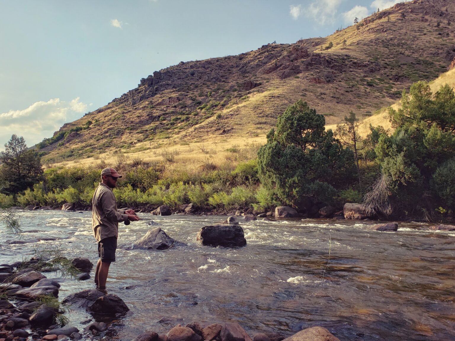
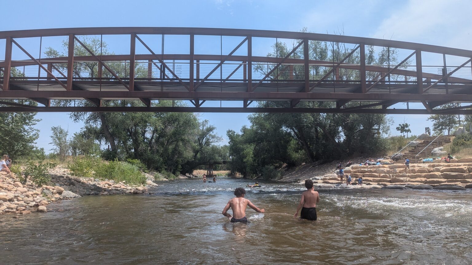
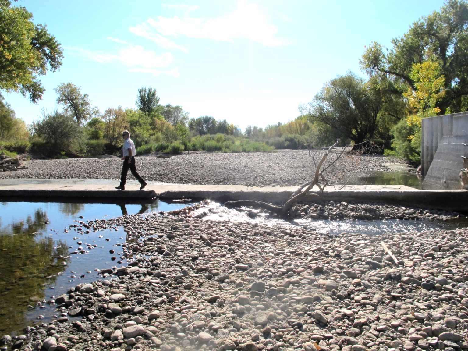


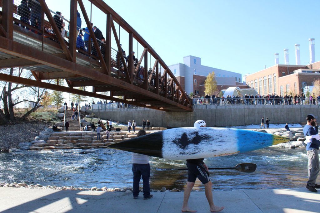
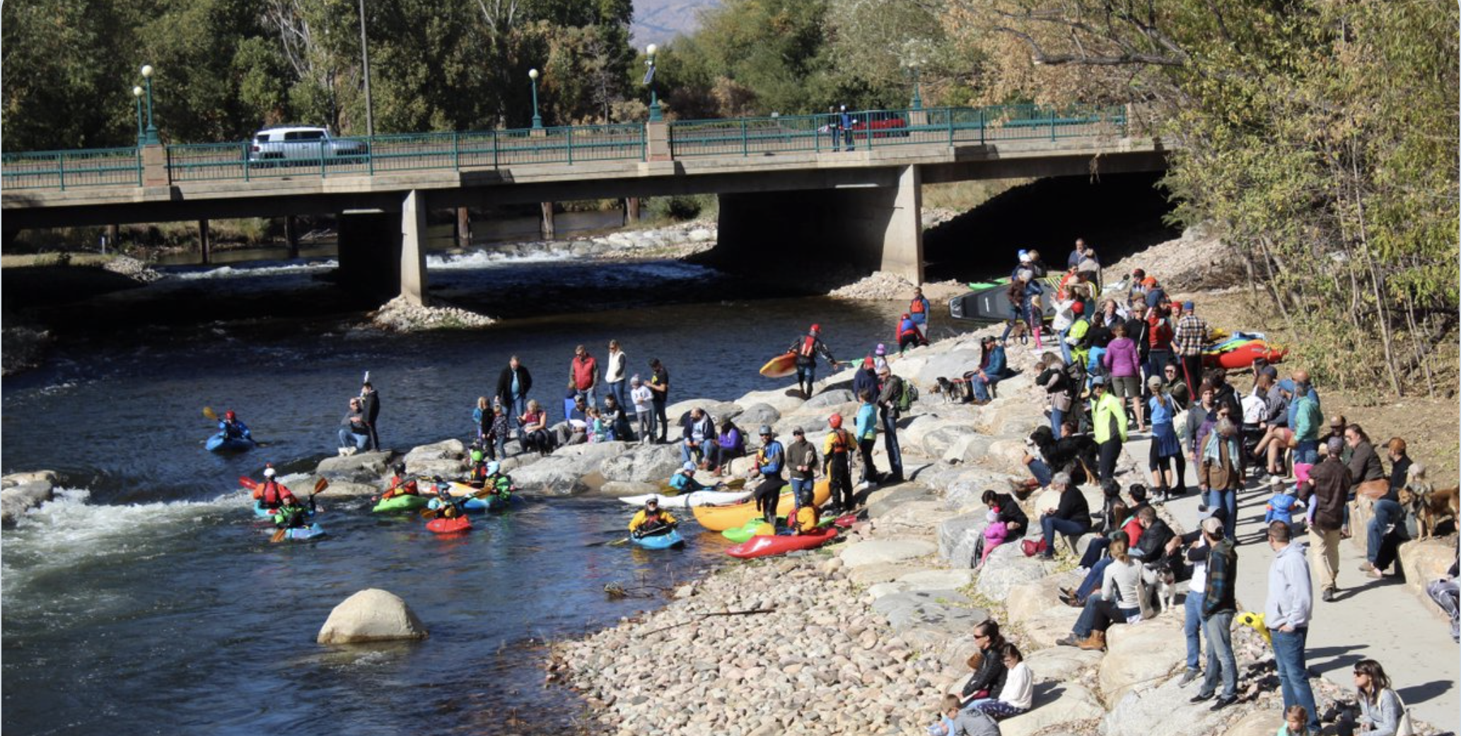
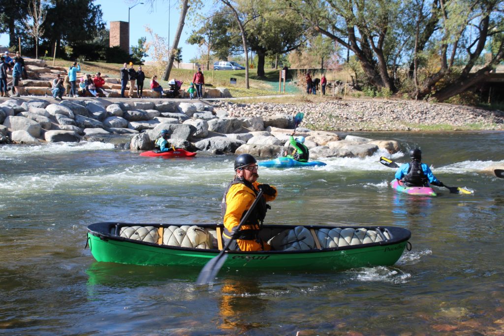
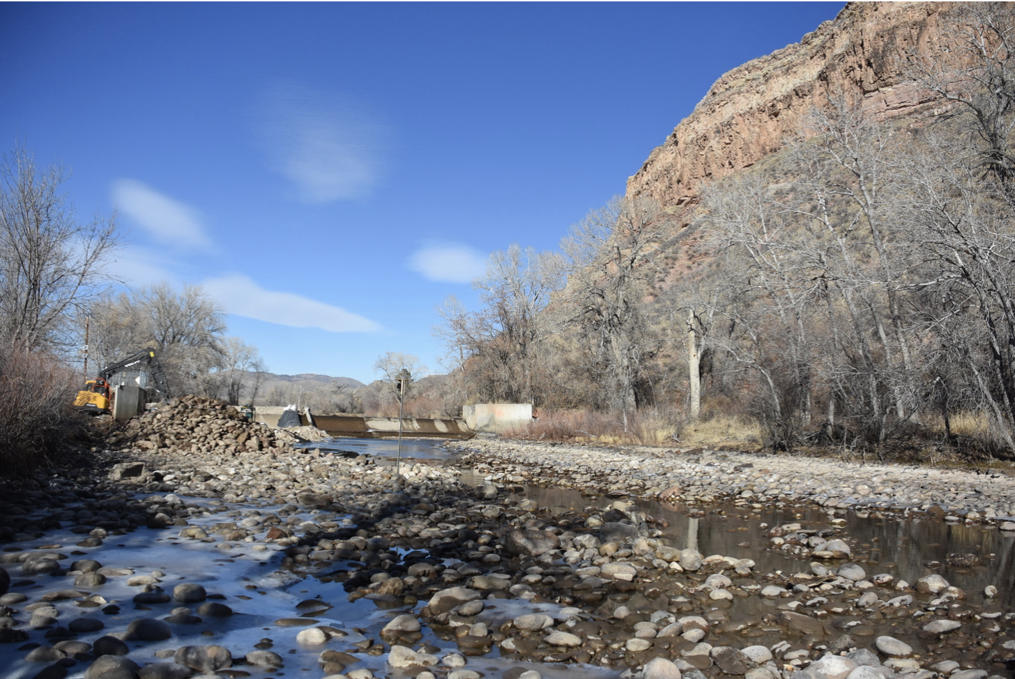


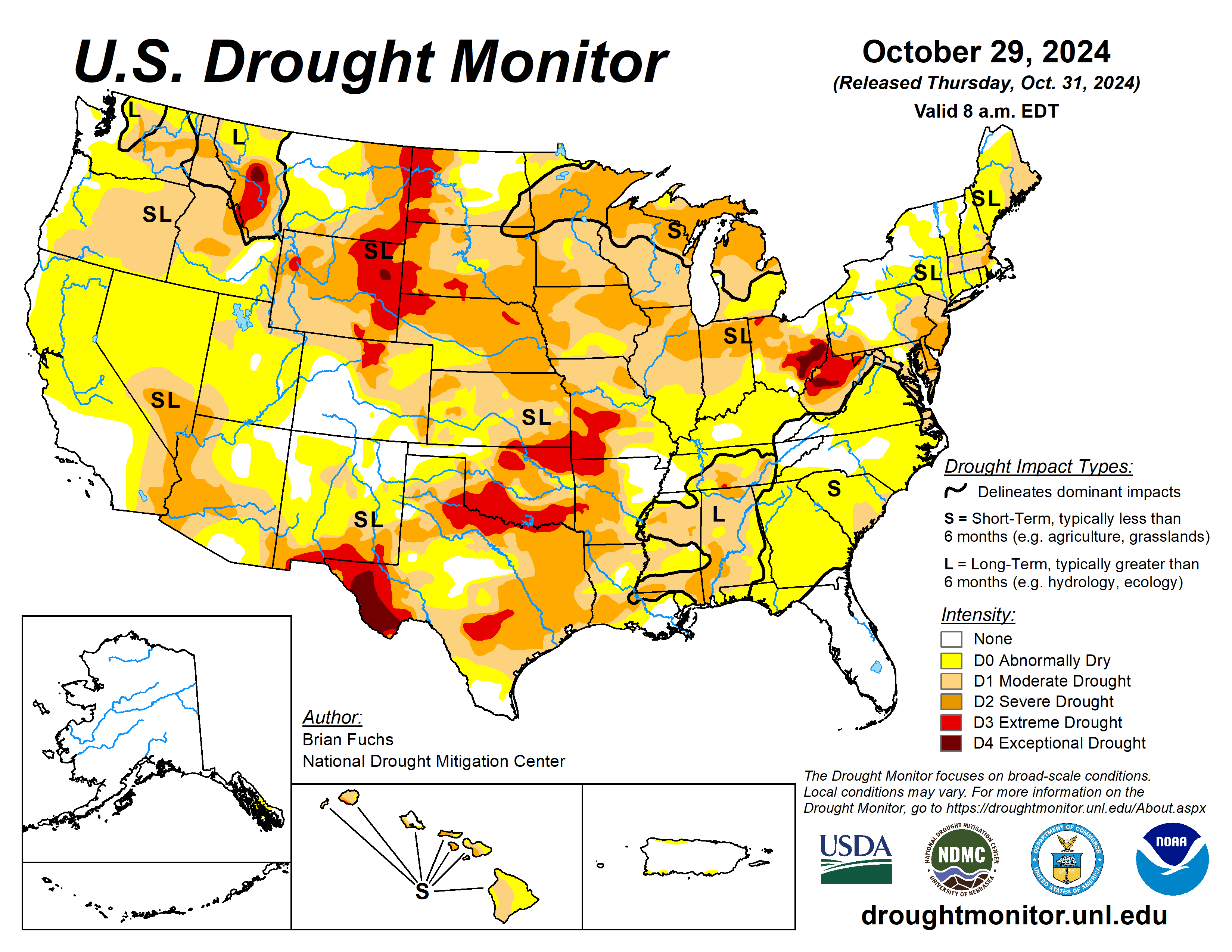

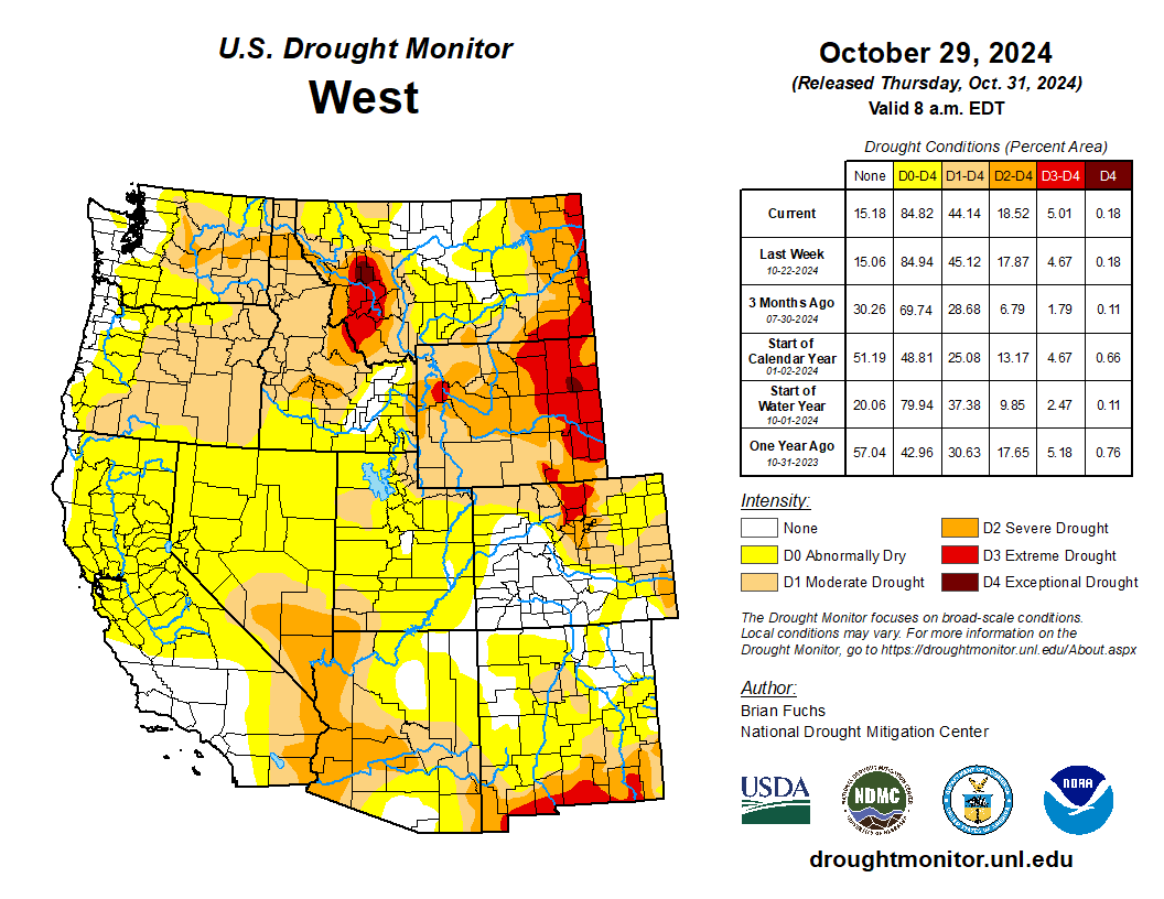
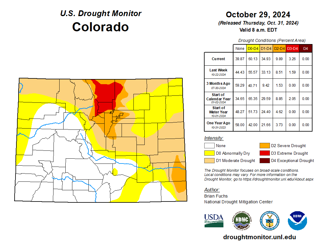

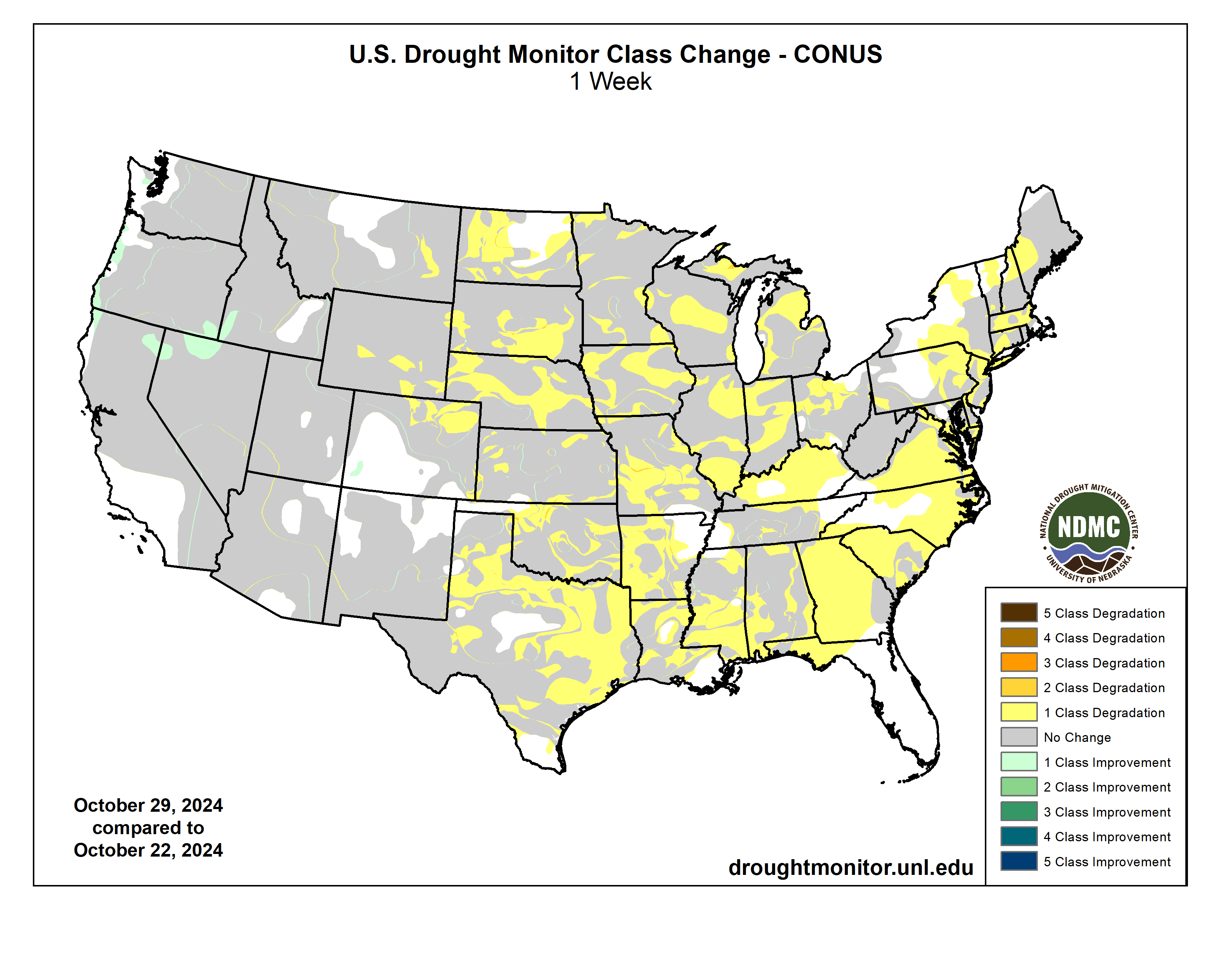


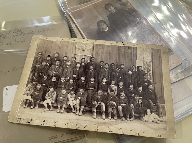


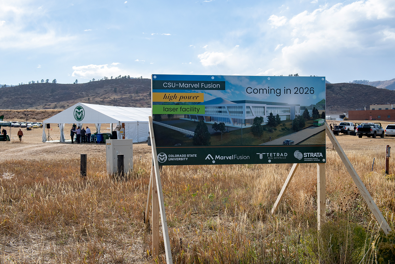
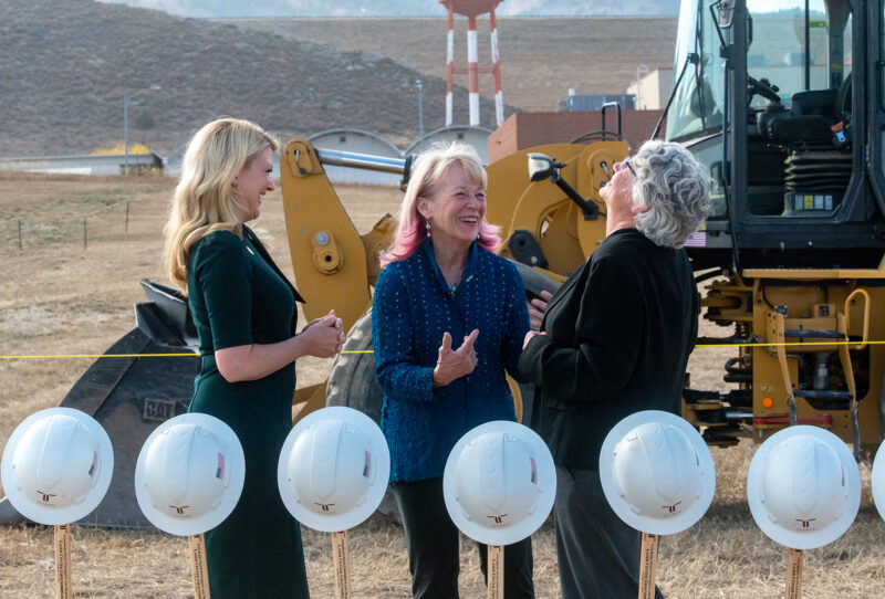


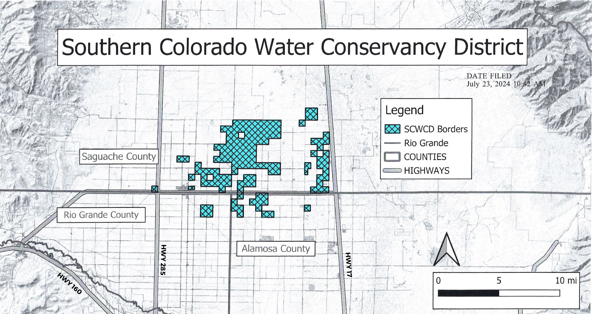


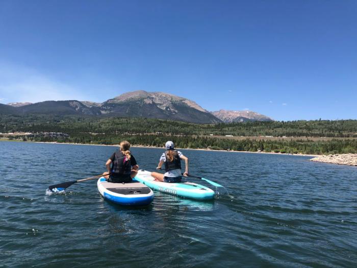


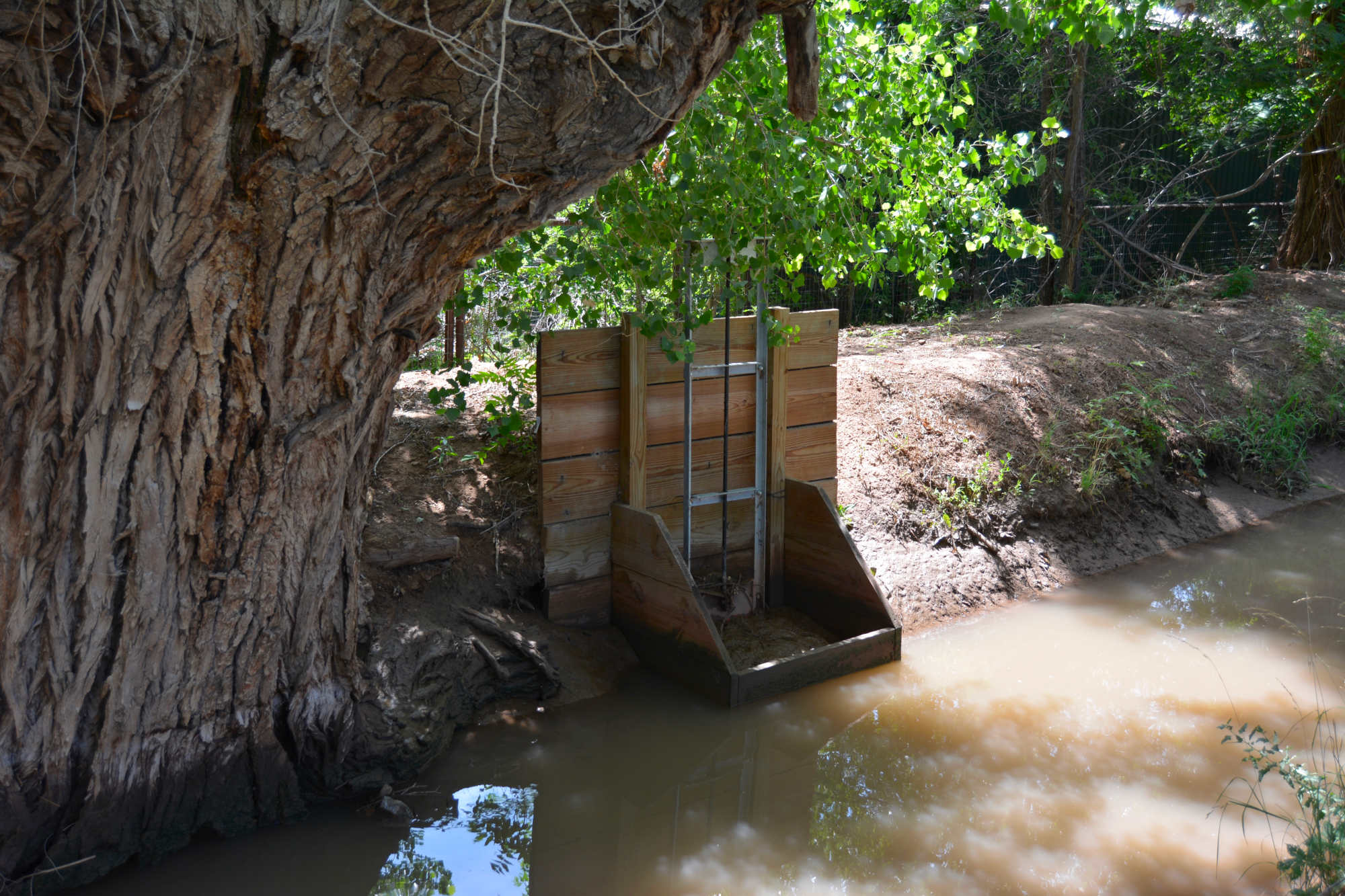
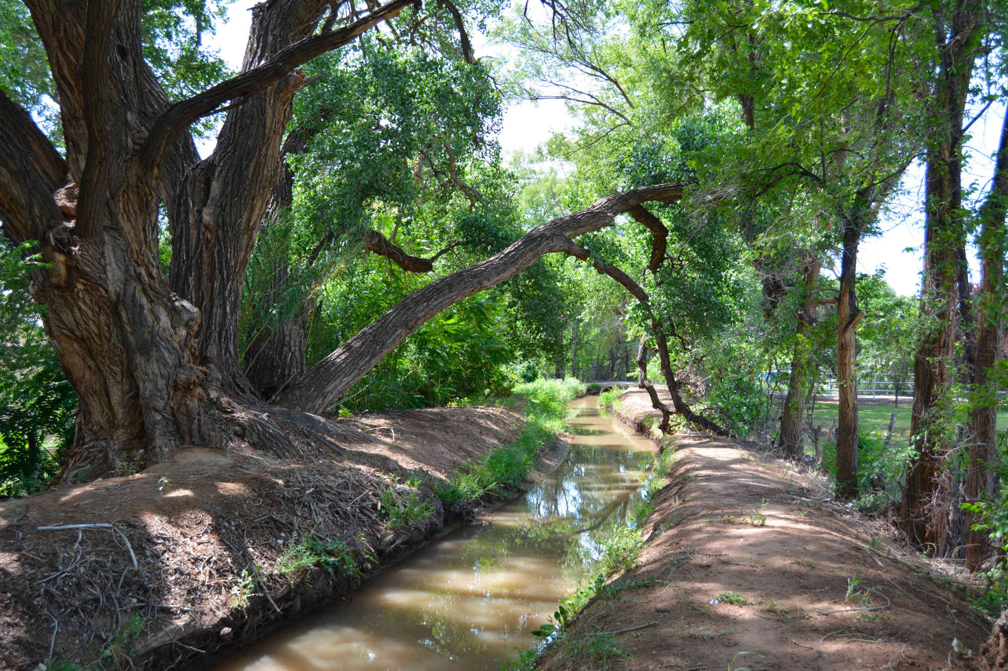

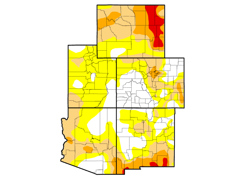
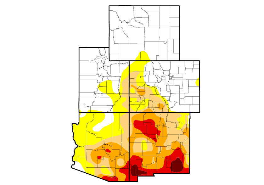

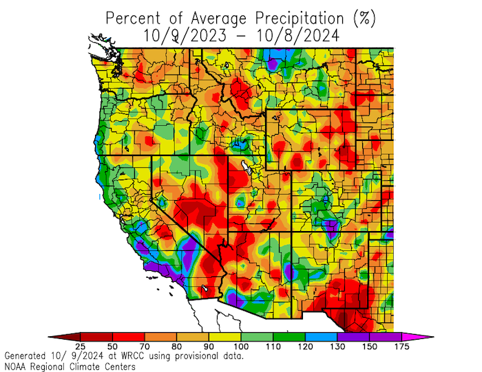

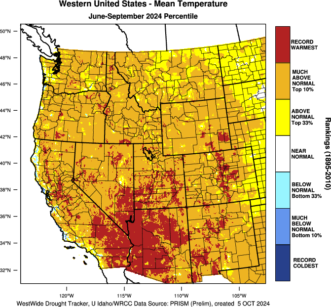
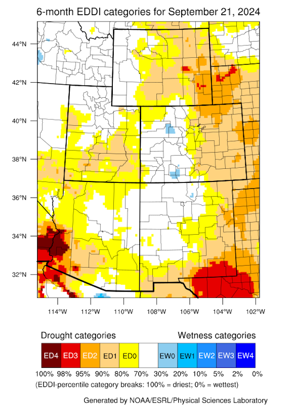
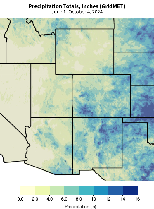
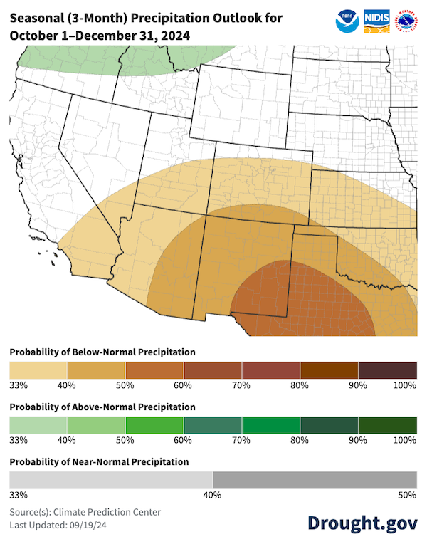


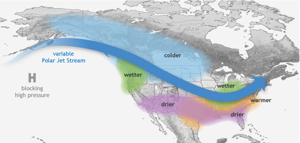

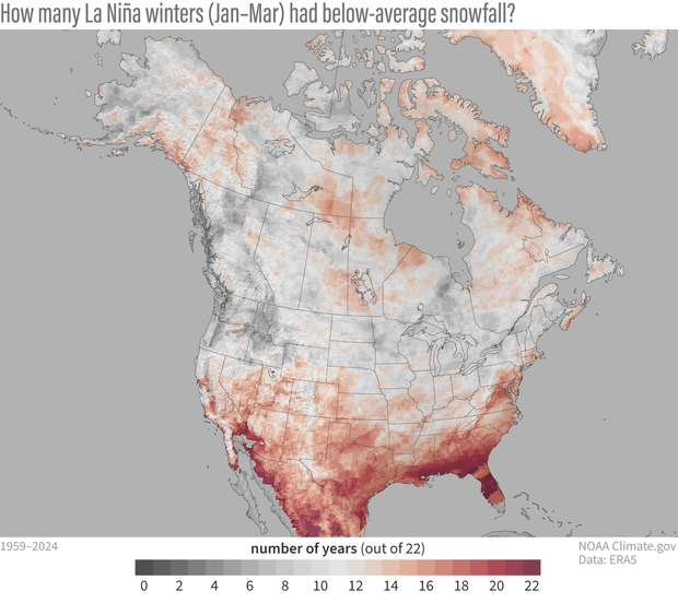
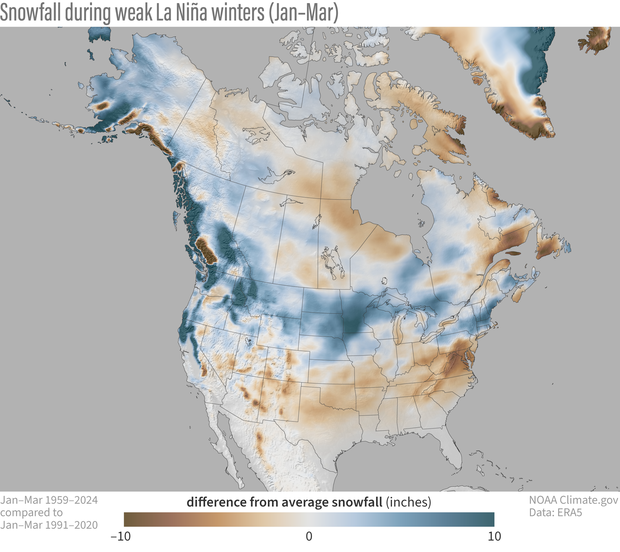

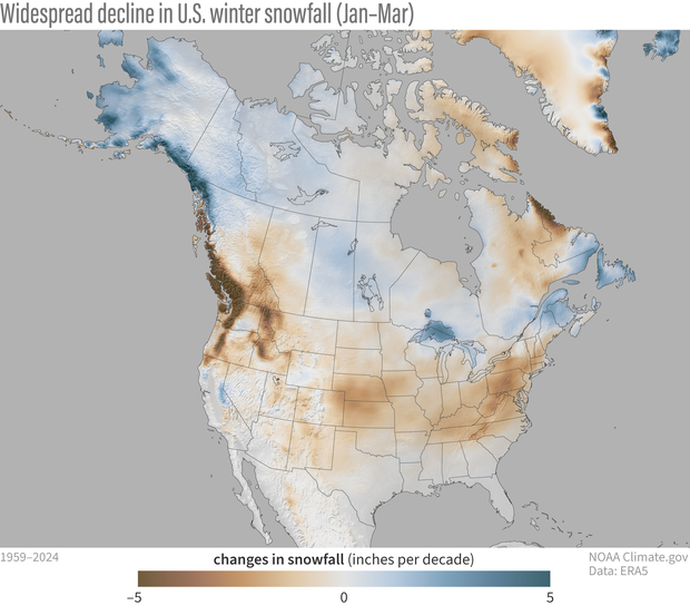


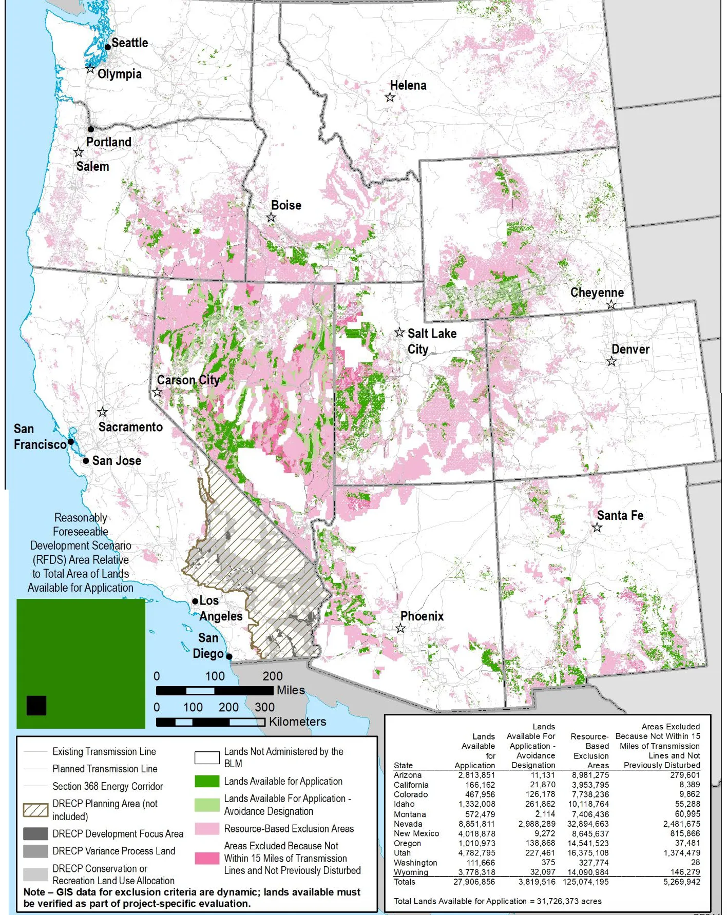


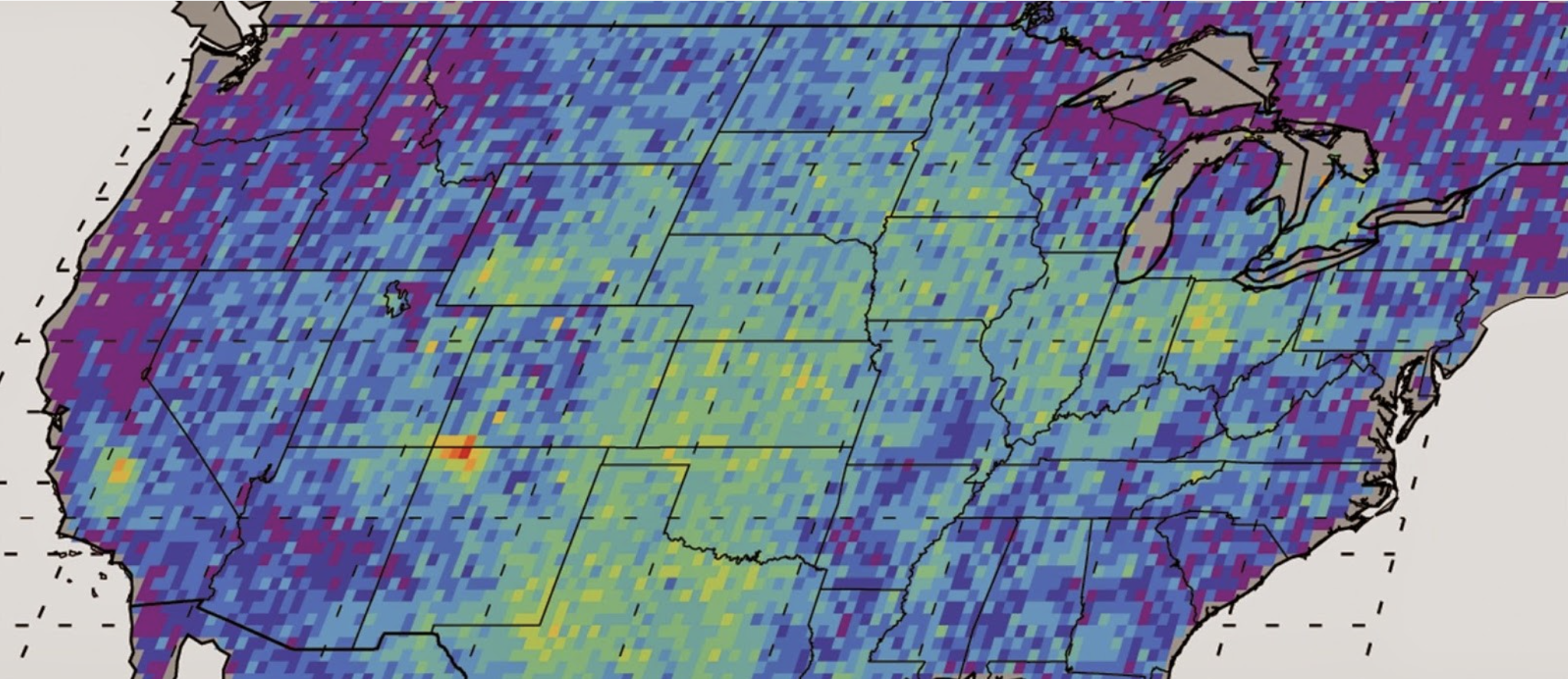

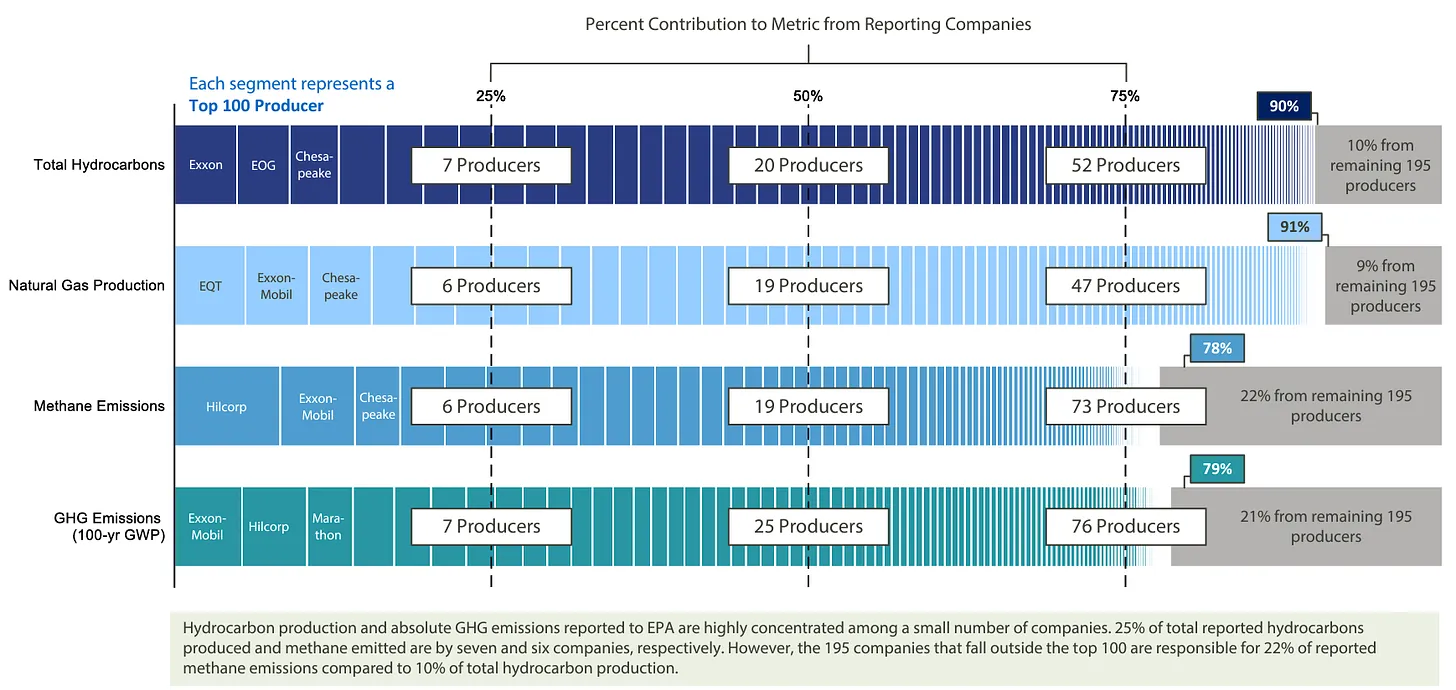

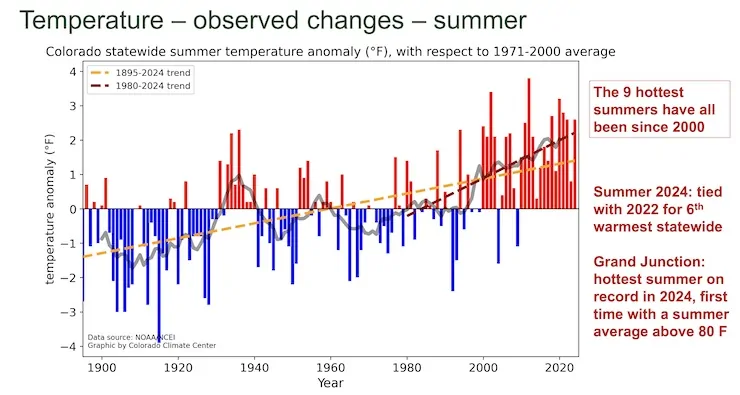


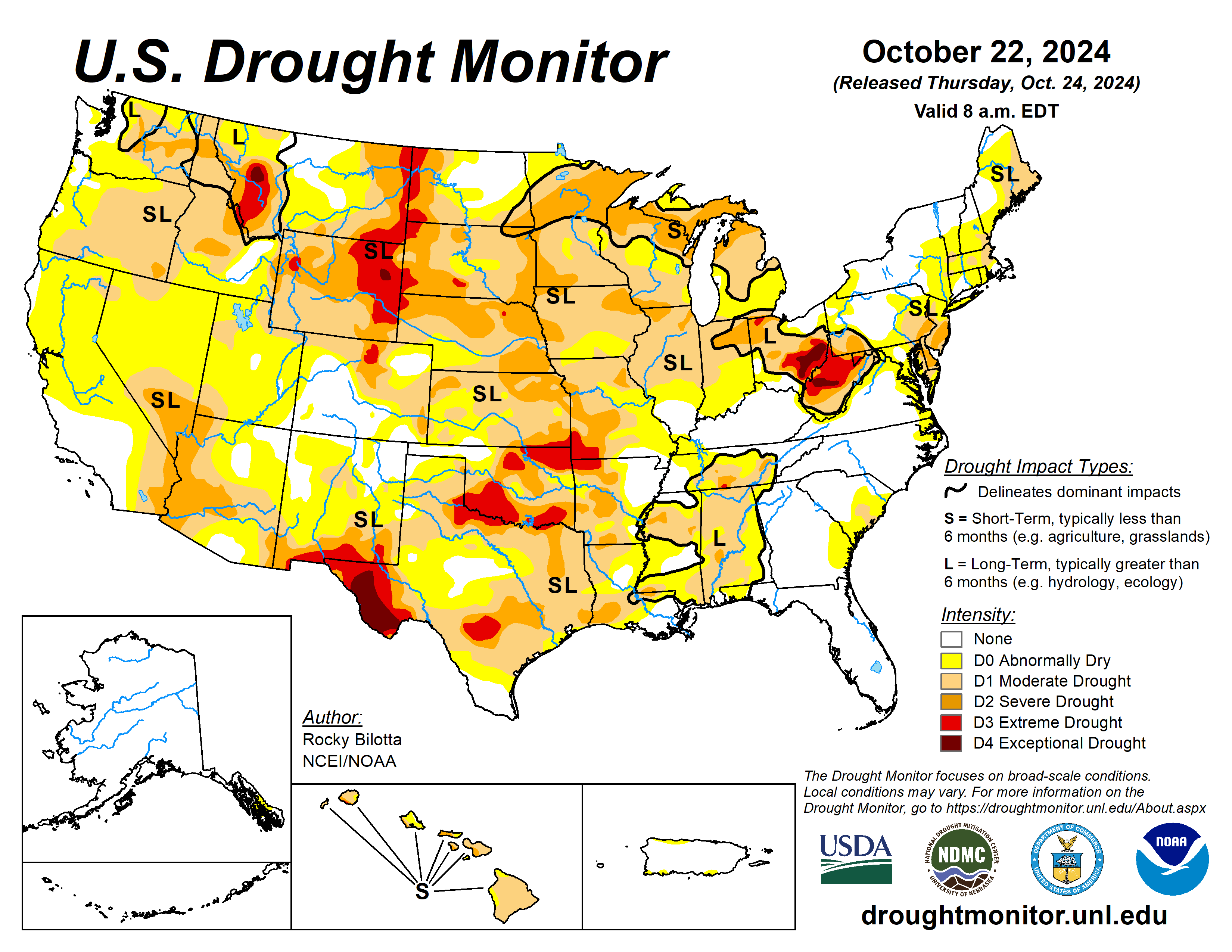

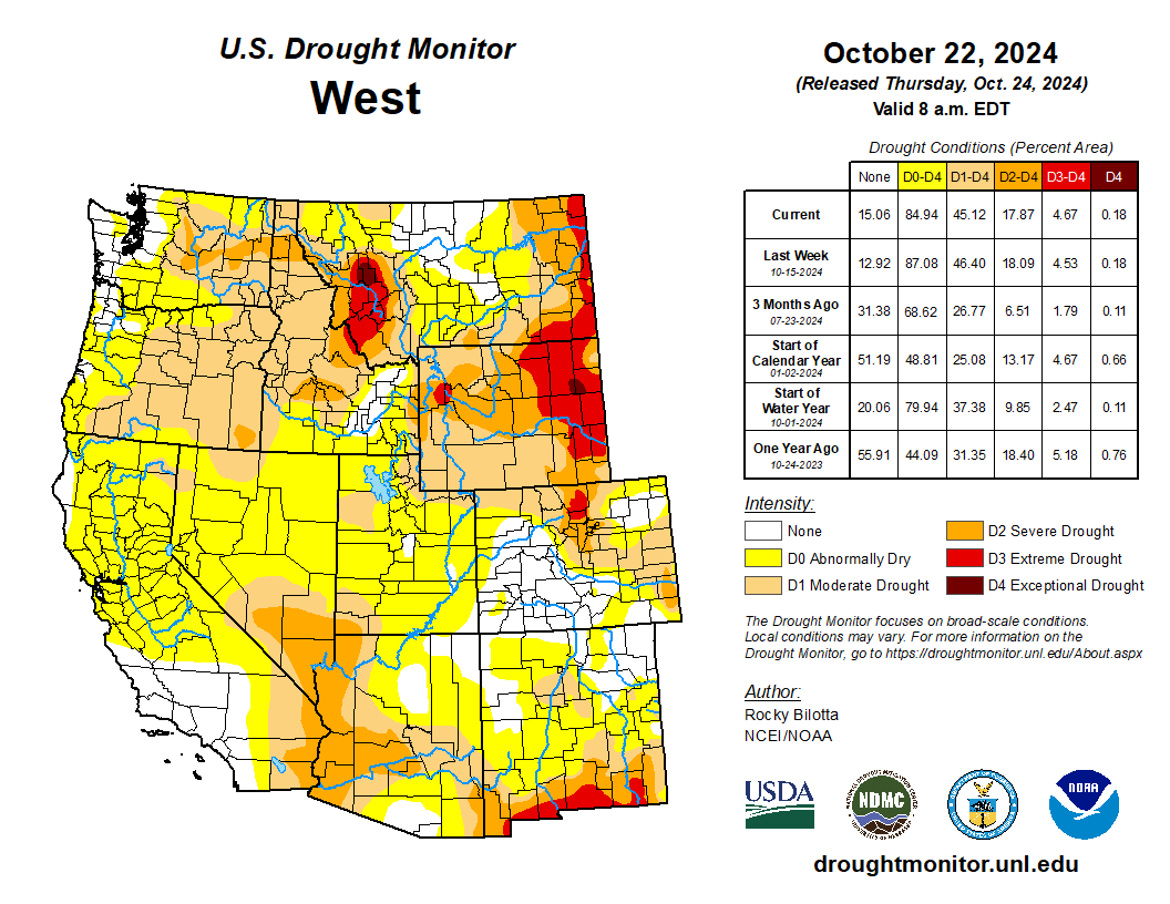
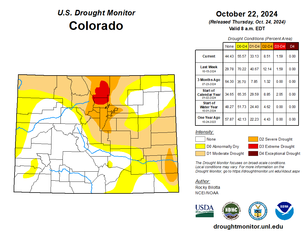
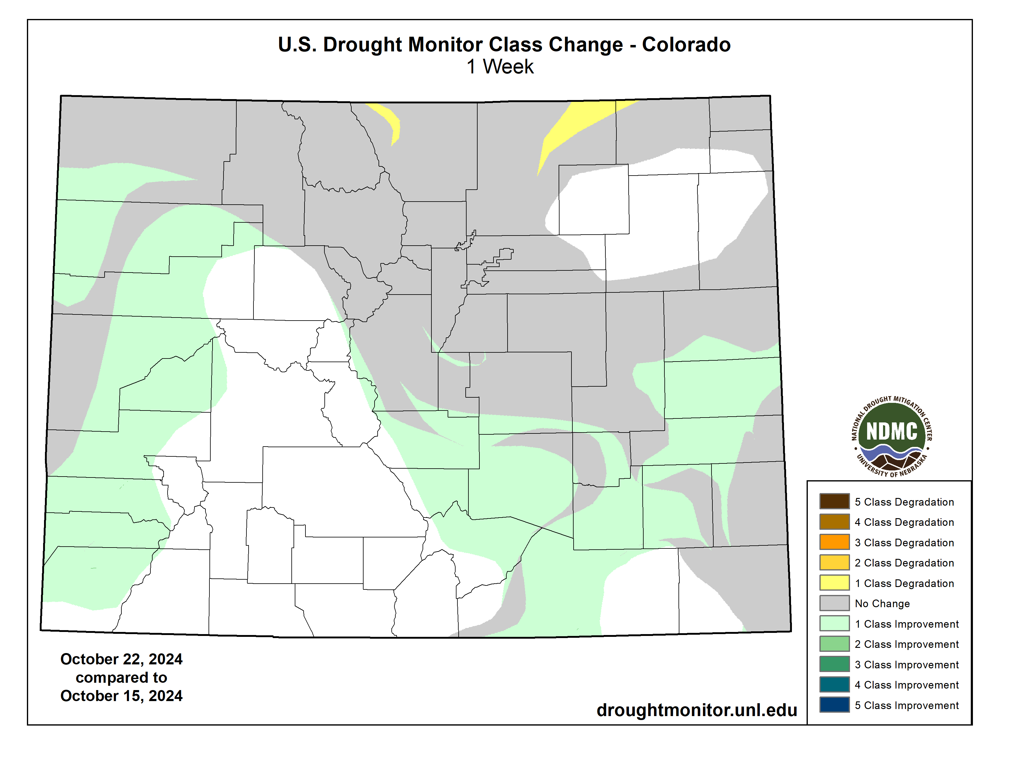


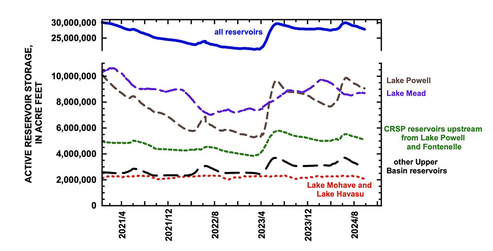


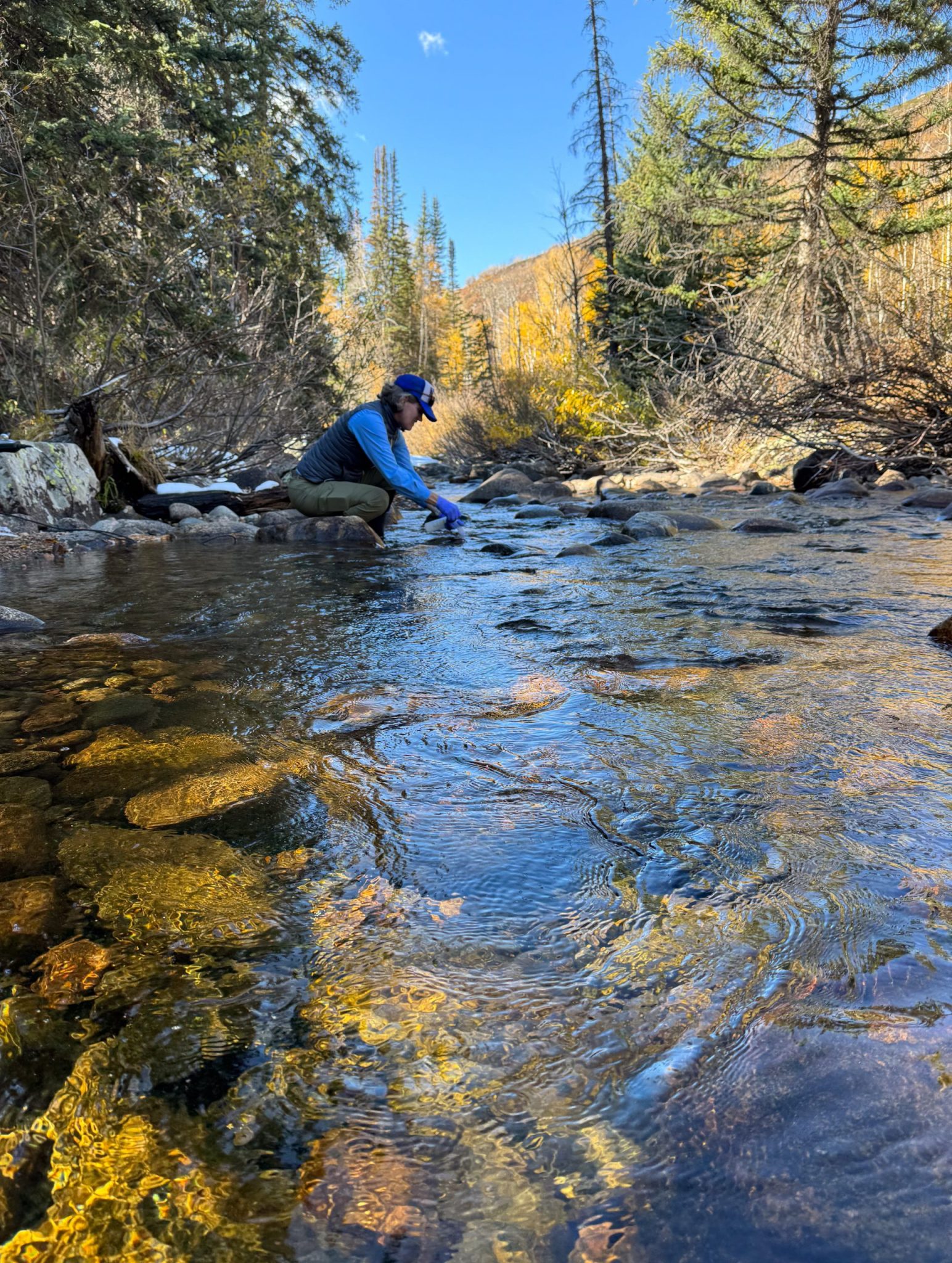


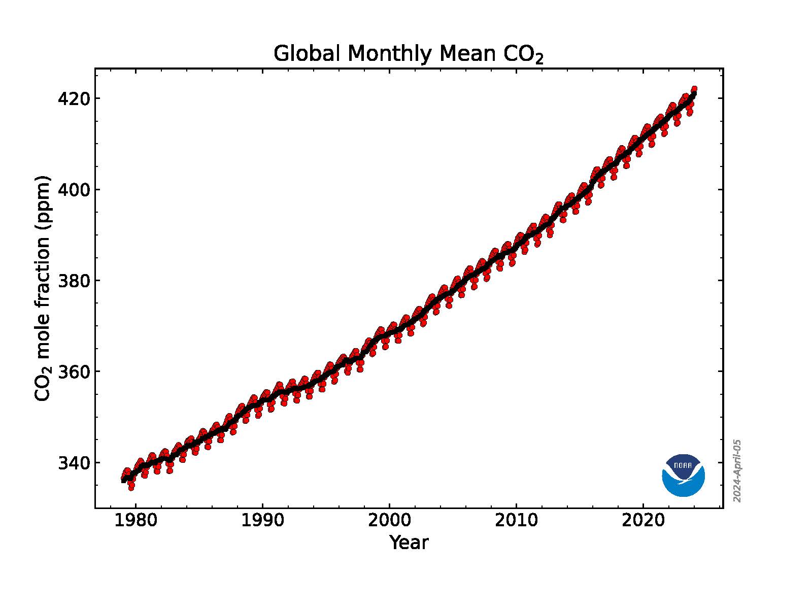


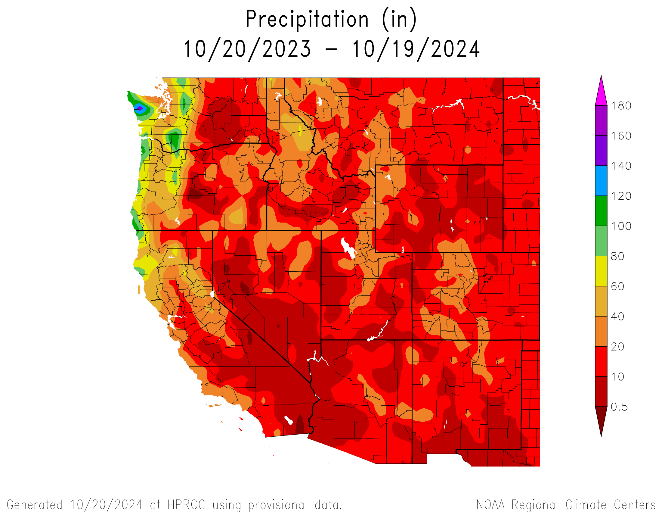


