Click on a thumbnail graphic to view a gallery of drought data from the US Drought Monitor website.

Click the link to go to the US Drought Monitor website. Here’s an excerpt:
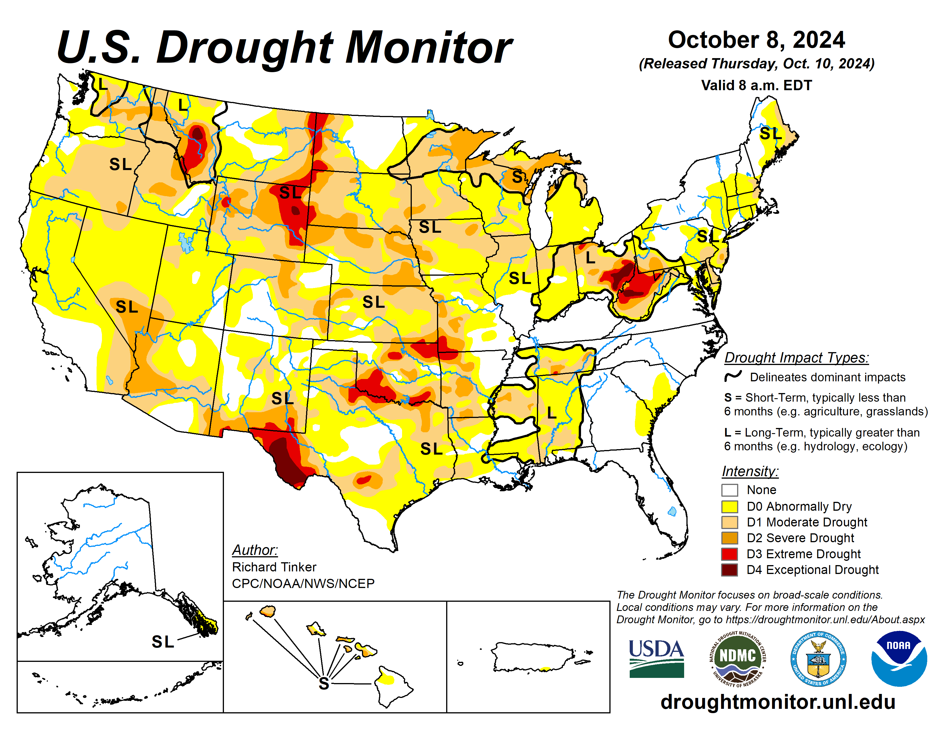
This Week’s Drought Summary
After the intense rains from Hurricane Helene tapered off, this past week was extremely dry over a large majority of the contiguous 48 states. Rainfall totals exceeding 2 inches were limited to much of the Florida Peninsula, the immediate central Gulf Coast, the Louisiana Bayou, and Deep South Texas. Several small, isolated locations across these areas reported as much as 5 inches of rain. Significant rainfall was hard to find in other areas. Several tenths of an inch, with isolated totals up to 1.5 inches, fell on Maine, southeastern New England, the central Appalachians and foothills, southeastern Virginia, the Upper Peninsula of Michigan, southeastern Iowa, west-central Illinois, and the Pacific Northwest from the Washington and northern Oregon Cascades to the Pacific Coast. The remainder of the country recorded at most 0.25 inch of precipitation, with a vast majority of the area measuring no precipitation for the week. This abetted recovery in places devastated by the intense rains and flooding associated with Hurricane Helene, but also caused dryness and drought to persist or intensify. Rapid deterioration was starting to take place in parts of the Lower Mississippi Valley and southern Great Plains while deterioration proceeded at a slower pace in other parts of the Nation affected by dryness and drought. In addition, unseasonably high temperatures accentuated the dryness in many areas, particularly in the Southwest…
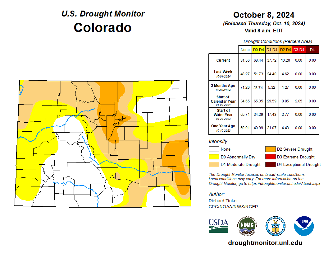
High Plains
It was very warm and almost bone dry throughout the region for the second successive week. As a result, D0 to D3 conditions all expanded broadly, and most of the region is currently experiencing some degree of dryness or drought. The only areas free of abnormal dryness are central and eastern North Dakota, a few parts of southwestern Nebraska and western Kansas, northeastern Colorado, and parts of southern and western Colorado. A small patch of exceptional drought (D4) was introduced in east-central Wyoming, and extreme drought (D3) expanded across a large part of eastern Wyoming, much of the western tier of the Dakotas, and a couple small patches in southeastern Kansas. Since early June, precipitation has totaled less than half of normal through most of east-central and northeastern Wyoming, and shorter-term deficits of varying intensities envelop most of the High Plains Region. In addition, dryness was exacerbated by high temperatures averaging at least 5 deg. F above normal last week region-wide, and more than 10 deg. F above normal in most of Colorado and Wyoming, plus a few other scattered patches…
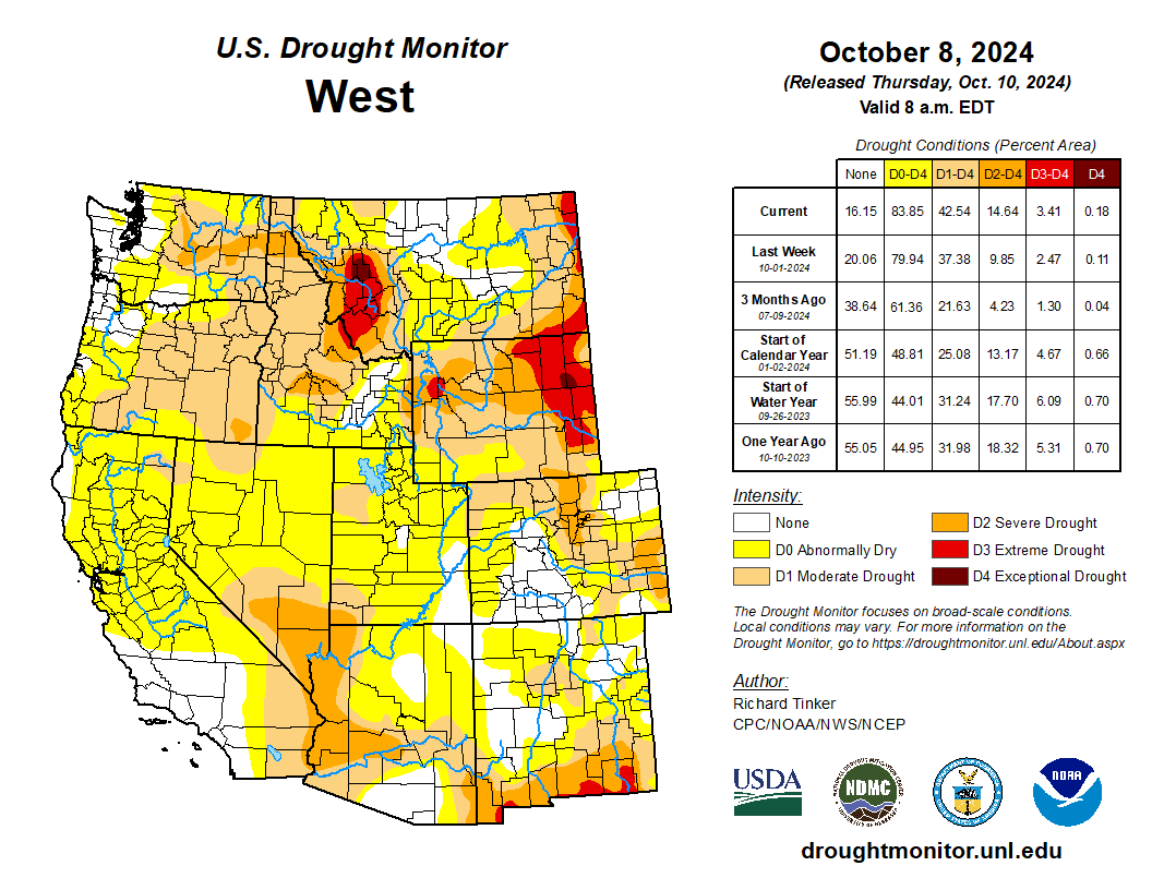
West
For the last couple of weeks, several tenths of an inch to over an inch of precipitation fell from the Cascades of Washington and northern Oregon westward to the Pacific Ocean, allowing temperatures to climb only slightly above normal and bringing an end to abnormal dryness in a small section of northwestern Washington where precipitation has been most significant. Slightly-elevated temperatures extended eastward through the state of Washington and some adjacent areas, but the rest of the West Region was significantly warmer than normal, with many areas reporting record or near-record heat for this time of year. Areas from southern Montana, central Idaho, and southern Oregon southward through the Great Basin, California, Arizona, and western New Mexico reported high temperatures averaging over 10 deg. F above normal, with most of California and the adjacent Southwest enduring almost summerlike heat 15 to 20 deg. F above normal for this time of year. For the past 2 months, high temperatures have averaged 4 to 8 deg. F above normal over central and eastern Montana, and through most of Arizona and some adjacent areas, including southern Nevada. A few locations in eastern Montana averaged more than 8 deg. F higher than normal. Drought tends to move slowly this time of year in the West Region, where light precipitation often doesn’t keep up with water loss to evapotranspiration and human usage, but the excessive heat has caused drought conditions to intensify at a quicker rate than usual. This past week, much of the West south and east of the Cascades saw conditions deteriorate sufficiently to justify an increase in the Drought Monitor classification, with a large D2 expansion in the Southwest as well as parts of eastern Washington and Idaho. D2 to D4 conditions (severe to exceptional drought) also covered western Montana, unchanged over the past several weeks. On the southern tier of the West Region, D2 and D3 conditions increased slightly in coverage over southern New Mexico. The area with some improvement was found in central Idaho due to the sustained effects of precipitation a few weeks back…
South
Over 2 inches of rain soaked Deep South Texas and the Louisiana Bayou, but amounts decreased rapidly moving away from these areas, and a vast majority of the region saw no measurable rain during the week. As a result, conditions began to quickly deteriorate over a large part of the region. Dryness and drought of most intensities (D0 to D3) expanded in coverage across large parts of Oklahoma and adjacent Texas, western and eastern Texas, and parts of Louisiana. In Mississippi, a re-assessment of 90- to 180-day precipitation totals and some unfavorably low agricultural statistics, such as reduced hay production, led to the re-introduction of some D2 in west-central and east-central Mississippi, although most locations in that state changed little from last week. Dryness and drought in Tennessee worsened in a few areas, but most locations were not declining as quickly as some areas farther west on the other side of the Mississippi River. Currently, exceptional drought (D4) covers a sizeable portion of western Texas, and extreme drought (D3) was assessed in the rest of western Texas, much of the Red River Valley (South), parts of northern Oklahoma, and northwestern Arkansas. Much of Oklahoma outside the Panhandle, adjacent Texas, and western Arkansas are 4 to 8 inches below normal rainfall since early June. Less than half or normal rain has fallen during this period across and near the Red River Valley (South). Daily high temperatures averaging over 10 deg. F above normal across most of Oklahoma and some adjacent locations worsened the rate of deterioration…
Looking Ahead
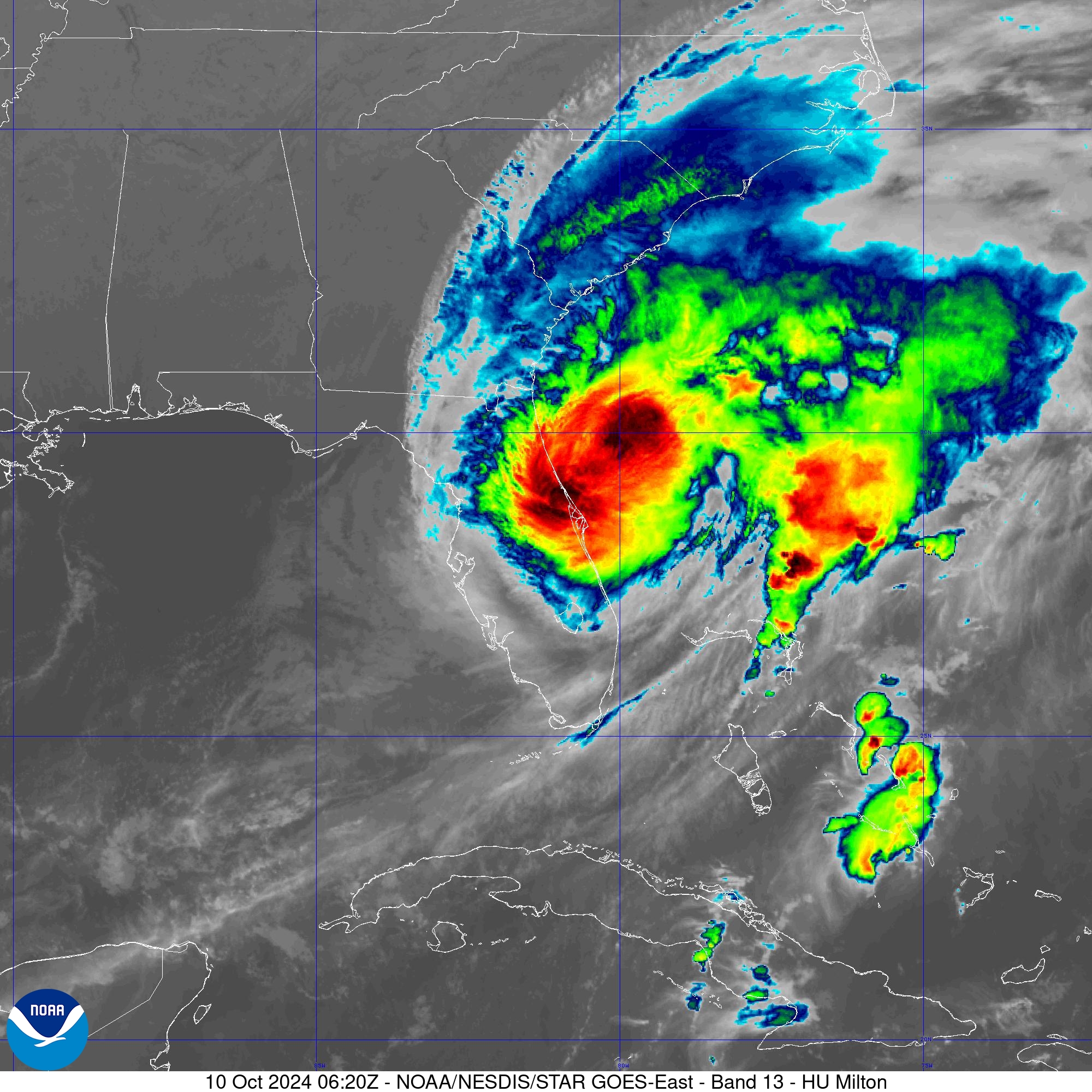
During the next five days (October 10 – 14), Hurricane Milton will contribute to excessive rainfall across much of the central and northern Florida Peninsula, but most other parts of the Nation should expect little precipitation, if any. Between 10 and 15 inches of rain are expected in part of the northeastern Florida Peninsula, and totals of at least 5 inches are expected from St. Petersburg and Cedar Key northward to the Florida Big Bend and the south side of Jacksonville. To the north and south of this band, precipitation totals will be considerably lower. Near or less than an inch is expected over most of the southern Florida Peninsula. Farther north, there will be a tight gradient between heavy rain and little or none, with totals over 0.25 inch no farther north than just north and west of the Florida Big Bend through extreme southeastern Georgia. Elsewhere, a frontal system is expected to drop 0.5 to 1.0 inch of rain from the northern and eastern Great Lakes through northwest Pennsylvania, upstate New York, and central and northern New England. Light to locally moderate totals (0.1 to 0.5 inch) are forecast aross the Upper Ohio Valley and southern New England, and across northwestern California from San Francisco to the Oregon border. Little or no precipitation is expected across the remainder of the contiguous U.S., including most areas impacted by dryness and drought. Near or slightly less than normal precipitation is expected in far southeastern Alaska. Meanwhile, temperatures are anticipated to be above normal from most of Texas and the High Plains westward to the Pacific Coast. Daily maximum temperatures are forecast to average 10 to 16 deg. F above normal across the northern halves of the Rockies and Intermountain West. In contrast, most locations east of the Mississippi River are expected to average cooler than normal, with highs averaging 4 to 6 deg. F below normal through most of the Appalachians, eastern Great Lakes, and New England.
Just for grins here’s a slideshow of early October US drought Monitor maps for the past few years.

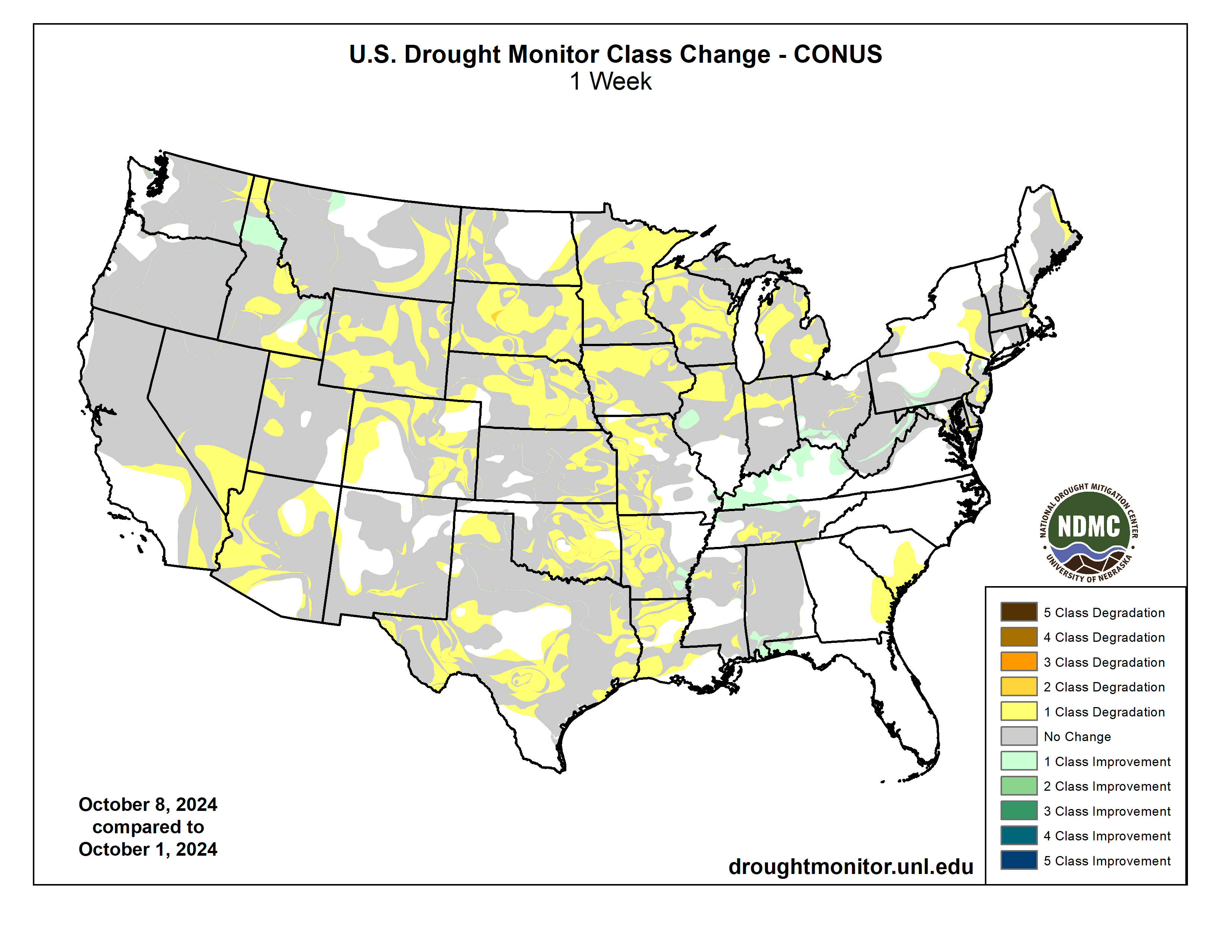
US Drought Monitor map October 8, 2024. 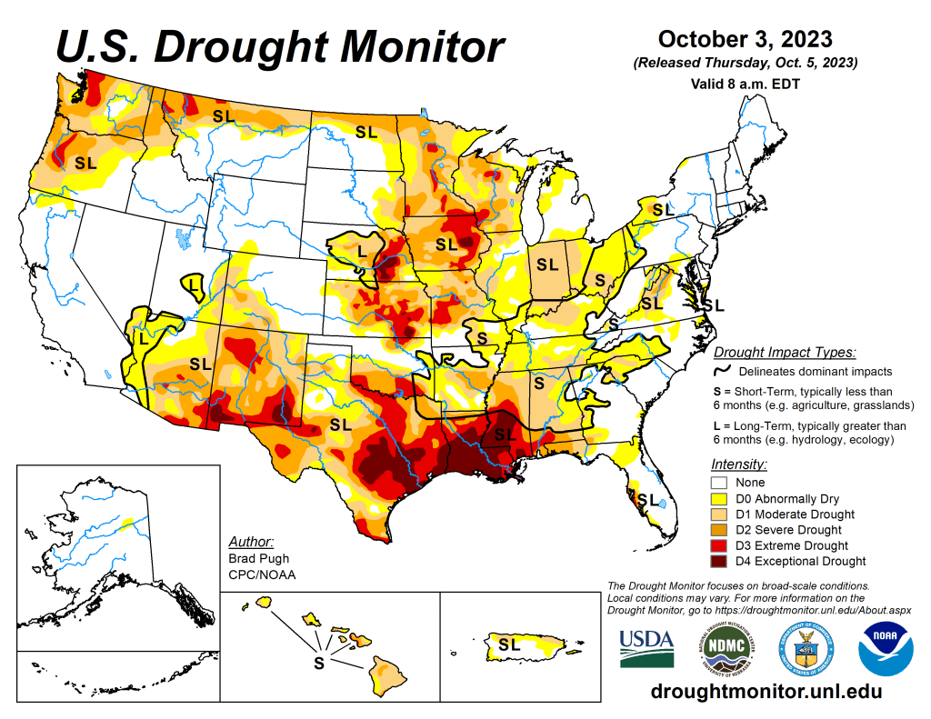
US Drought Monitor map October 3, 2023. 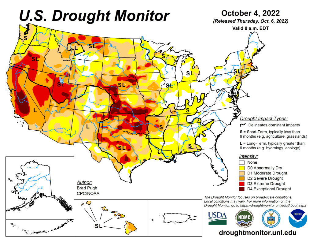
US Drought Monitor map October 4, 2022. 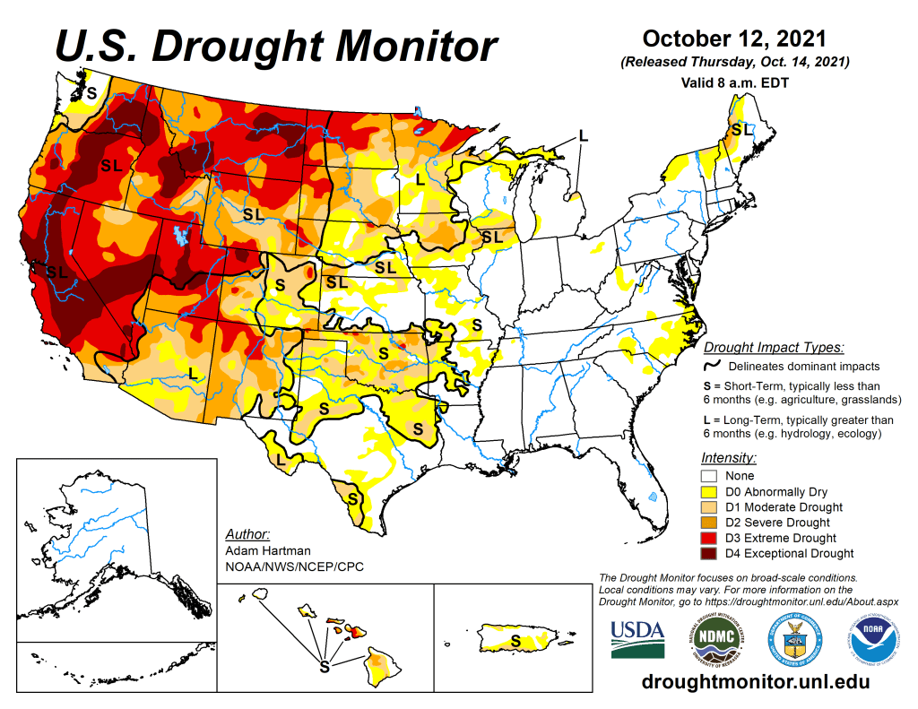
US Drought Monitor map October 12, 2021. 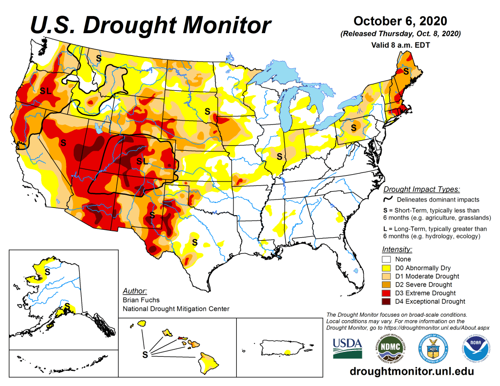
US Drought Monitor October 6, 2020. 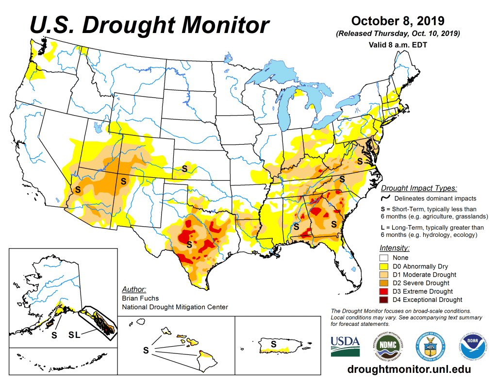
US Drought Monitor October 8, 2019. 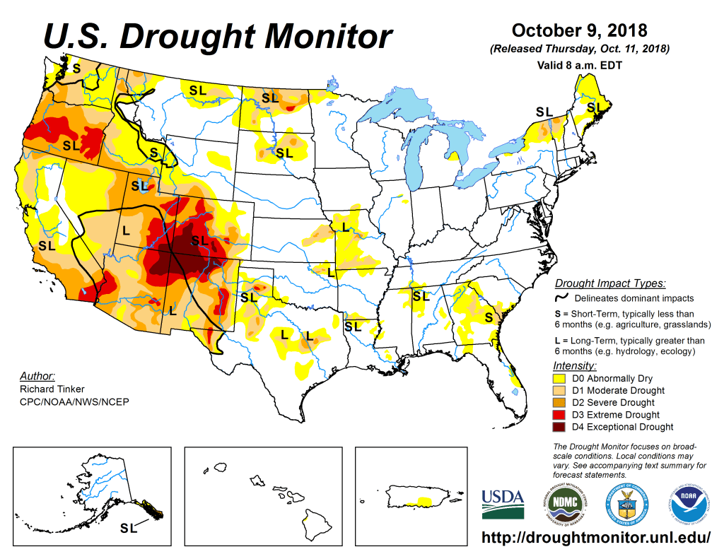
US Drought Monitor October 9, 2018. 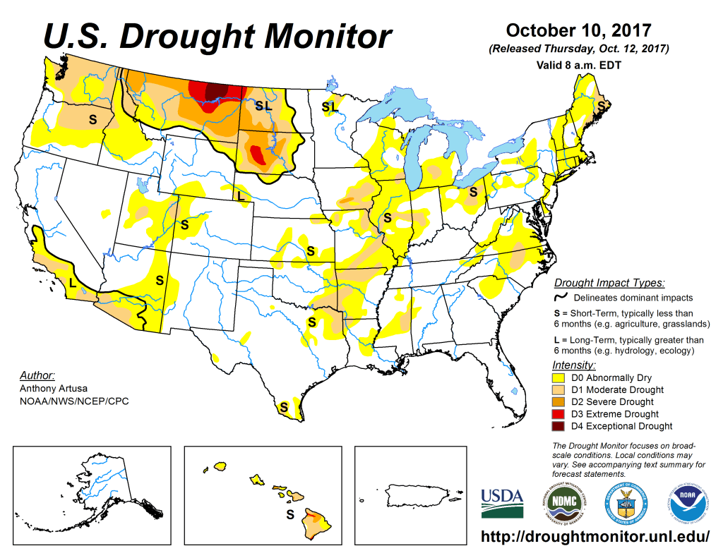
US Drought Monitor October 20, 2017. 
US Drought Monitor October 4, 2016. 
US Drought Monitor October 6, 2015 
US Drought Monitor October 7, 2014 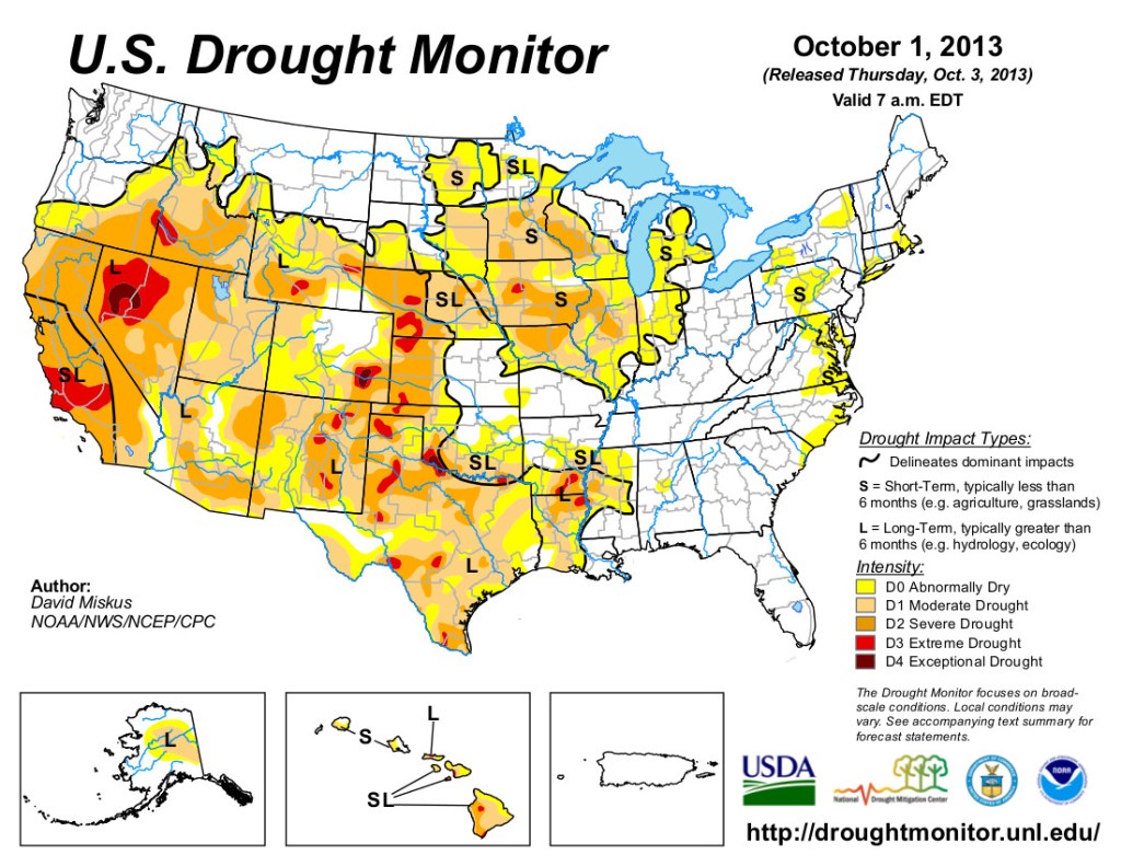
US Drought Monitor October 1, 2013 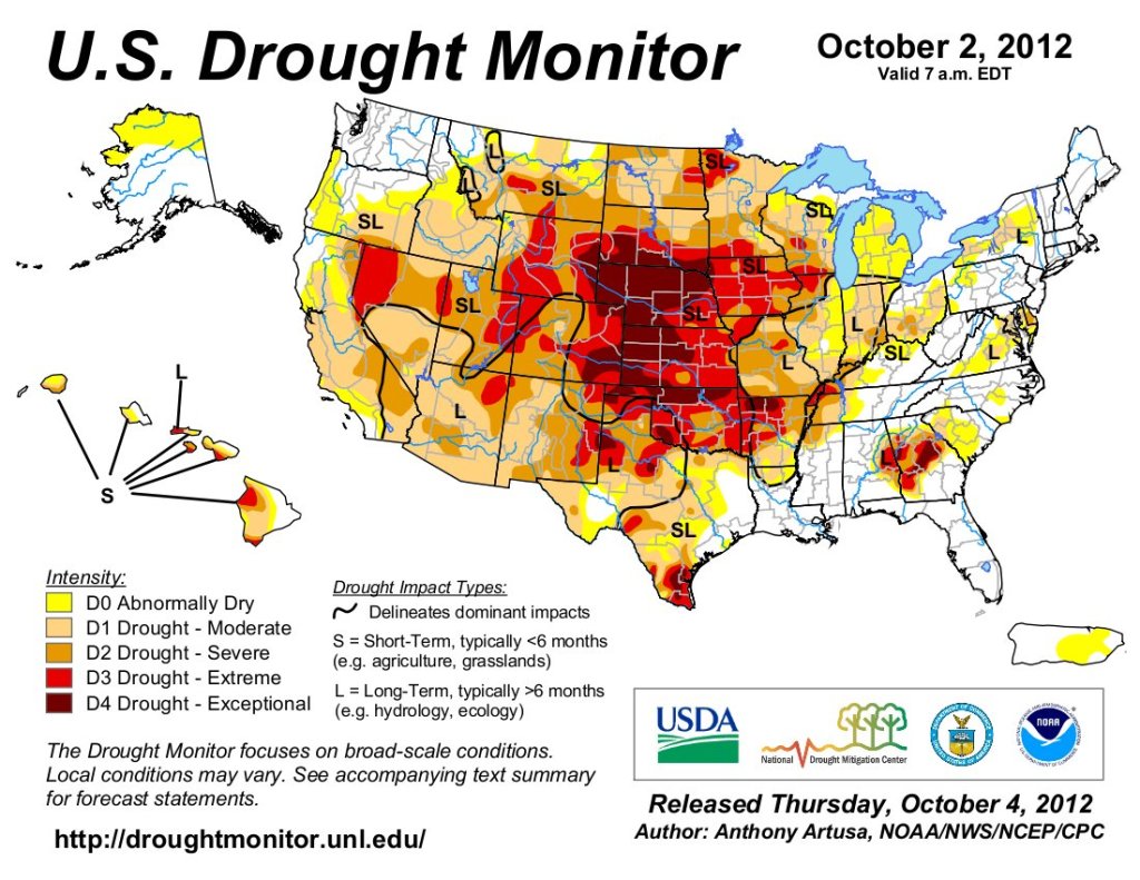
US Drought Monitor map October 2, 2012. 
US Drought Monitor map October 15, 2010.