Migrating birds find refuge in pop-up habitats: A program that pays rice farmers to create wetland habitats is a rare conservation win — @HighCountryNews

Photo credit: Think Rice U.S. Grown

Click the link to read the article on the High Country News website (Natalia Mesa):

October 11, 2024

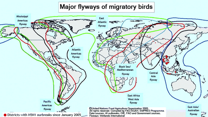
Every July, the western sandpiper, a dun-colored, long-beaked bird, leaves the shores of Alaska and migrates south. It may fly as far as the coast of Peru, where it spends several months before making the return trip. Western sandpipers travel along the Pacific Flyway, a strip of land that stretches along the Western coast of the Americas, from the Arctic down to Patagonia. The wetlands of California’s Central Valley offer sandpipers and thousands of other species a crucial place to rest and feed along the way. In September, at the peak of the southward migration season, tens of millions of birds stop there.

But intensive farming and development have destroyed 95% of the Central Valley’s wetlands, and as the wetlands have disappeared, the number of migrating birds has plummeted. Shorebirds like the western sandpiper, which dwell in seashores and estuaries, are particularly imperiled, declining by more than 33% since 1970.

In 2014, in the middle of a particularly punishing drought in California, a network of conservation organizations called the Migratory Bird Conservation Partnership tried a new strategy to help migrating birds: paying rice farmers to create “pop-up” habitat. The program, which is called BirdReturns and was initially funded by The Nature Conservancy, has since created tens of thousands of acres of temporary wetlands each year.

Map showing the global routes of migratory birds. Credit: John Lodewijk van Genderen via Reseachgate.net

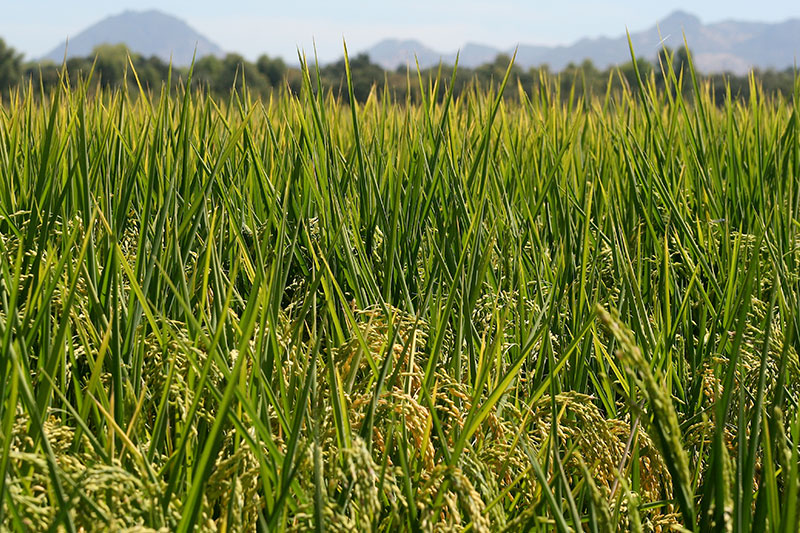
Rice farmers in the Central Valley flood their fields when the growing season ends, generally around November, and keep them flooded until February to help the leftover vegetation decompose. They plant their crop after the fields dry out in late spring. The program pays rice farmers in the birds’ flight path to flood their fields a bit earlier in the fall and leave them flooded later in the spring. This creates habitat when the migratory birds need it the most, as they fly southward in the late summer and early fall and pass through again on their way north in the spring.

Daniel Karp, a researcher at UC Davis who studies conservation in working landscapes and is not involved in BirdReturns, sees the program as a rare conservation win. Most of the time, small farms that grow many different crops, plant hedgerows and pollinator-friendly flowers are the best way to conserve biodiversity in human-dominated landscapes. But although rice farmers grow only one crop, their large fields are an exception. While it’s far from a complete solution, “it’s this weird rare circumstance where you have a large industrial-scale intensive agricultural system that can simultaneously support wildlife,” Karp said.

Map of the San Joaquin River basin in central California, United States, made using public domain USGS National Map data. By Shannon1 – Own work, CC BY-SA 4.0, https://commons.wikimedia.org/w/index.php?curid=63080408

BirdReturns started with just 10,000 acres in the Sacramento Valley. In 2021, it expanded to the San Joaquin Valley Delta. The program now has a network of regional partners who lead their own reverse auction programs, such as the similar Bid4Birds, piloted by the California Ricelands Waterbird Foundation.

Map of the Sacramento River drainage basin. The historically connected Goose Lake drainage basin is shown in orange. Made using USGS National Map and NASA SRTM data. By Shannon1 – Own work, CC BY-SA 4.0, https://commons.wikimedia.org/w/index.php?curid=79326436

Over the last nine years, BirdReturns has created 120,000 acres of bird habitat. Though it’s a far cry from the 4 million acres of wetlands present before colonial settlement, studies have shown that shorebird density is 2 to 3.5 times greater in pop-up wetlands than in other rice fields. And BirdReturns is fine-tuning its approach based on data, feedback from farmers, and ongoing research: A study published in early September analyzing nearly 9,000 field observations over five years gave scientists more information about the factors that create good shorebird habitat. For example, more shorebirds tend to visit fields where the water is shallow, especially if they’re flooded consistently, for months at a time as well as year after year.

BirdReturns also has the flexibility to adapt as conditions change from year to year. During droughts, for example, the program prioritizes places that birds have visited in the past. In wetter years, it might scale back. “The findings of your results are applied right away to on-the-ground actions,” said Greg Golet, senior scientist for The Nature Conservancy, who is involved in the program.

Challenges remain, though. The migration and agriculture cycles are not fully synchronized, making it difficult for rice farmers to flood their land early enough to create habitat for shorebirds, especially the long-distance migrants that might appear as early as July. BirdReturns has recently tackled other strategies, partnering with tomato farmers, who grow crops a bit earlier in the year and thus can flood their fields earlier.

And there’s still the question of how this practice can continue sustainably, especially as climate change-fueled drought makes water increasingly scarce, Karp said. In drought years, it’s costly to pay farmers to keep their lands flooded, if they have any water to spare at all. There’s no simple solution or easy answers, but for now, BirdReturns and similar programs are coming up with “creative solutions,” Karp said. “We thought we could rely on protected areas to conserve habitat globally, and we now know that’s not enough, and we need to complement that with a suite of different conservation strategies,” said Natalia Ocampo-Peñuela, a conservation ecologist at University of California, Santa Cruz, who is not involved with BirdReturns. While market-based solutions shouldn’t be the only answer, she said, they are “a piece of the puzzle.”

Modeling the Future of the #ColoradoRiver in a Changing #Climate — Fresh Water News #COriver #aridification

dCrystal Lake with San Juan mountains in the background near the Uncompahgre River – one of the tributaries of the Colorado River. Photo by M. Raffae

Click the link to read the article on the Water Education Colorado website (Raffae Muhammed):

October 11, 2024

The importance of the Colorado River cannot be overstated for the American West. The river and its tributaries serve more than 40 million people by providing drinking and municipal water. The water from the river basin irrigates more than 5 million acres of land, which produces around 15% of the nation’s crops. The dams in the basin generate 4,200 megawatts of hydro-power. Overall, the river system sustains over 16 million jobs, contributes $1.4 trillion per year to the economy, and supports terrestrial and aquatic ecosystems (USBR, 2012.)

West Drought Monitor map October 8, 2024.

However, the current drought that has lingered for decades now poses a significant threat to everything that depends on the mighty Colorado River. The river basin lies in the region which is infamous for its natural variability. Over the course of history, the region has had cycles of dry and wet periods, which may also make the present drought look like a natural phenomenon alone. However, a study conducted in 2021 showed that around 19% of the current drought conditions can be attributed to human-induced climate change. Not only that, but the conditions are worse than they have been in at least 1200 years.

Since 90% of the streamflow in the Colorado River originates in the upper part of the basin,several studies over the years have focused on watershed modeling in that region many studies have investigated historical flows, while others have included baseflow – the steady release of groundwater that seeps into a stream or river. Some have gone further to use historical streamflow and baseflow to predict future conditions in the river basin using various climate models. However, almost all studies have either used pre-development scenarios – conditions when there was little to no water infrastructure such as dams, canals, levees, etc., management, and regulations – or have used oversimplified models that ignore the complexities of groundwater movement, storage, and interactions with the surface water.

The Colorado River Basin is one of the most highly regulated and over-allocated river systems in the world. As a result, basing studies on pre-development scenarios seems to be of little practical importance in this day of rapidly changing climate. Moreover, the importance of groundwater and its interactions with surface water cannot be ignored, as more than half of the streamflow in the basin is contributed by baseflow.

Colorado transmountain diversions via the State Engineer’s office

The river basin also has trans-basin or trans-mountain diversions. These diversions bring water from the western slope of the Rocky Mountains, which are in the Colorado River Basin, to the eastern slope of the Rockies outside of the basin. These diversions have also been ignored in previous models.

Map credit: AGU

Therefore, my team, which includes my Ph.D. advisor at CSU, Associate Professor Ryan Bailey, and two scientists from the Agricultural Research Service, is working to address this knowledge gap by incorporating key hydrological processes that were overlooked in previous research studies. We are using a physically based and spatially distributed model to build and quantify historical streamflows and groundwater levels in the Upper Colorado River Basin for the post-development scenario. A physically based model simulates how water moves through the environment, using real-world processes, instead of relying on statistical patterns. A spatially distributed model, on the other hand, takes into account differences in the landscape and natural features across different areas. In our model, we have included reservoirs, canals, irrigation schedules, floodplains, trans-basin diversions, and tile drainage – an agricultural drainage system that removes excess subsurface water from irrigated fields. The model also simulates groundwater fluxes such as groundwater recharge, canal seepage, tile drainage flow, saturation excess flow, lake and reservoir seepage and evaporation, and groundwater-floodplain exchanges, which can be used to identify spatio-temporal patterns in the river basin.

Once we simulate the historical hydrology and fluxes, we plan to run what-if scenarios, hypothetical situations to help us analyze different options, for several water management, land use change, and climate change scenarios. This will allow us to come up with best management practices to address water issues and manage water resources more effectively and efficiently.

Historic photo of the Lee’s Ferry gage on the Colorado River. Photo credit: USGS

In the final phase of the study, we use what-if scenarios to assess the political and socio-economic aspects of the model. This includes, crop budgets, agricultural productivity in monetary terms, possibility and probability of Denver getting shut out from trans-mountain diversions in case of a drought, economic implications of sustainable groundwater use, the amount of water flowing at Lee’s Ferry in Arizona – the dividing point of the upper and lower basins, and so on.

The findings of this study can influence how water managers, government agencies, farmers, and other stakeholders approach water use and management for higher revenues and sustainability. Ecologists can gain insights into future streamflows and their potential impacts on aquatic ecosystems. Additionally, it will provide the scientific community with a solid foundation and valuable catalyst for future research. In the long run, these findings can help shape water policy, advancing the goal of achieving integrated regional water management.

M. Raffae

The fate of the Colorado River Basin does not only depend on the climate and its variability, but also on the policies we create that define how we store, move, use, and manage our water. To come up with policies that help us sustain the economy, environment, and society, it is imperative that we conduct a comprehensive hydrological modeling study for the post-development scenario that shows us both our best- and worst-case scenarios for the future to better prepare for it. This study is an ambitious attempt to do so.

About the author: M. Raffae is a Ph.D. student in the Department of Civil and Environmental Engineering at Colorado State University (CSU) funded by the Fulbright Foreign Student scholarship program. He is also a fellow in the NSF Research Traineeship (NRT) Program InTERFEWS at CSU.

Steamboat II Metro District water, sewer rates facing significant increase — Steamboat Pilot & Today

With leaky water and sewer pipe infrastructure dating to the early 1970s, the Steamboat II Metropolitan District is facing a proposed steep increase in water and sewer base rates to be voted on at a board meeting Monday, Oct. 21, 2024. The district water and sewer service covers three neighborhoods, two schools and a church, pictured in 2022 from above. Charlie Dresen/Courtesy photo

Click the link to read the article on the Steamboat Pilot & Today website (Suzie Romig). Here’s an excerpt:

October 11, 2024

With aging water and sewer pipe infrastructure dating to the early 1970s, a water main break repair and a section of line replacement in the Steamboat II Metropolitan District in 2022 cost more than $500,000…Those types of expensive repairs hit hard for the special taxing district that currently has $600,000 in reserves for capital improvements, said Jeb Brewster, a mechanical engineer and Steamboat II metro district manager since April. Regional experts say shortages in funds to repair aging infrastructure is a problem threatening various residential-based special taxing districts across Routt County that do not have as deep of pockets as cities and counties.

So, the Steamboat II district that serves water and sewer customers for some 420 residential properties, two schools and a church is faced with approving a proposed water and sewer combined rate jump of approximately 46%. The five-member volunteer district board is expected to vote on the increase at its next meeting Oct. 21…Metro district leaders note the water and sewer base rates charged to their customers have not increased significantly for at least 20 years except for minor increases in usage tiers. Water tap fees for homes being built helped supplement the budget in the past, but now the district is very close to full build-out.

Let’s check in and see how October temperatures in #Alaska have changed over the last 50 years — Brian Brettschneider (@Climatologist49)

Atmospheric rivers are shifting poleward, reshaping global weather patterns — The Conversation

Atmospheric rivers are long filaments of moisture that curve poleward. Several are visible in this satellite image. Bin Guan, NASA/JPL-Caltech and UCLA

Zhe Li, University Corporation for Atmospheric Research

Atmospheric rivers – those long, narrow bands of water vapor in the sky that bring heavy rain and storms to the U.S. West Coast and many other regions – are shifting toward higher latitudes, and that’s changing weather patterns around the world.

The shift is worsening droughts in some regions, intensifying flooding in others, and putting water resources that many communities rely on at risk. When atmospheric rivers reach far northward into the Arctic, they can also melt sea ice, affecting the global climate.

In a new study published in Science Advances, University of California, Santa Barbara, climate scientist Qinghua Ding and I show that atmospheric rivers have shifted about 6 to 10 degrees toward the two poles over the past four decades.

Atmospheric rivers on the move

Atmospheric rivers aren’t just a U.S West Coast thing. They form in many parts of the world and provide over half of the mean annual runoff in these regions, including the U.S. Southeast coasts and West Coast, Southeast Asia, New Zealand, northern Spain, Portugal, the United Kingdom and south-central Chile.

California relies on atmospheric rivers for up to 50% of its yearly rainfall. A series of winter atmospheric rivers there can bring enough rain and snow to end a drought, as parts of the region saw in 2023.

Atmospheric rivers occur all over the world, as this animation of global satellite data from February 2017 shows. NASA/Goddard Space Flight Center Scientific Visualization Studio

While atmospheric rivers share a similar origin – moisture supply from the tropics – atmospheric instability of the jet stream allows them to curve poleward in different ways. No two atmospheric rivers are exactly alike.

What particularly interests climate scientists, including us, is the collective behavior of atmospheric rivers. Atmospheric rivers are commonly seen in the extratropics, a region between the latitudes of 30 and 50 degrees in both hemispheres that includes most of the continental U.S., southern Australia and Chile.

Our study shows that atmospheric rivers have been shifting poleward over the past four decades. In both hemispheres, activity has increased along 50 degrees north and 50 degrees south, while it has decreased along 30 degrees north and 30 degrees south since 1979. In North America, that means more atmospheric rivers drenching British Columbia and Alaska.

A global chain reaction

One main reason for this shift is changes in sea surface temperatures in the eastern tropical Pacific. Since 2000, waters in the eastern tropical Pacific have had a cooling tendency, which affects atmospheric circulation worldwide. This cooling, often associated with La Niña conditions, pushes atmospheric rivers toward the poles.

The poleward movement of atmospheric rivers can be explained as a chain of interconnected processes.

During La Niña conditions, when sea surface temperatures cool in the eastern tropical Pacific, the Walker circulation – giant loops of air that affect precipitation as they rise and fall over different parts of the tropics – strengthens over the western Pacific. This stronger circulation causes the tropical rainfall belt to expand. The expanded tropical rainfall, combined with changes in atmospheric eddy patterns, results in high-pressure anomalies and wind patterns that steer atmospheric rivers farther poleward.

An animation of satellite data shows sea surface temperatures changing over months along the equator in the eastern Pacific Ocean. When they're warmer than normal, that indicates El Niño forming. Cooler than normal indicates La Nina.
La Niña, with cooler water in the eastern Pacific, fades, and El Niño, with warmer water, starts to form in the tropical Pacific Ocean in 2023. NOAA Climate.gov

Conversely, during El Niño conditions, with warmer sea surface temperatures, the mechanism operates in the opposite direction, shifting atmospheric rivers so they don’t travel as far from the equator.

The shifts raise important questions about how climate models predict future changes in atmospheric rivers. Current models might underestimate natural variability, such as changes in the tropical Pacific, which can significantly affect atmospheric rivers. Understanding this connection can help forecasters make better predictions about future rainfall patterns and water availability.

Why does this poleward shift matter?

A shift in atmospheric rivers can have big effects on local climates.

In the subtropics, where atmospheric rivers are becoming less common, the result could be longer droughts and less water. Many areas, such as California and southern Brazil, depend on atmospheric rivers for rainfall to fill reservoirs and support farming. Without this moisture, these areas could face more water shortages, putting stress on communities, farms and ecosystems.

In higher latitudes, atmospheric rivers moving poleward could lead to more extreme rainfall, flooding and landslides in places such as the U.S. Pacific Northwest, Europe, and even in polar regions.

A long narrow band of moisture sweeps up toward California, crossing hundreds of miles of Pacific Ocean.
A satellite image on Feb. 20, 2017, shows an atmospheric river stretching from Hawaii to California, where it brought drenching rain. NASA/Earth Observatory/Jesse Allen

In the Arctic, more atmospheric rivers could speed up sea ice melting, adding to global warming and affecting animals that rely on the ice. An earlier study I was involved in found that the trend in summertime atmospheric river activity may contribute 36% of the increasing trend in summer moisture over the entire Arctic since 1979.

What it means for the future

So far, the shifts we have seen still mainly reflect changes due to natural processes, but human-induced global warming also plays a role. Global warming is expected to increase the overall frequency and intensity of atmospheric rivers because a warmer atmosphere can hold more moisture.

How that might change as the planet continues to warm is less clear. Predicting future changes remains uncertain due largely to the difficulty in predicting the natural swings between El Niño and La Niña, which play an important role in atmospheric river shifts.

As the world gets warmer, atmospheric rivers – and the critical rains they bring – will keep changing course. We need to understand and adapt to these changes so communities can keep thriving in a changing climate.

Zhe Li, Postdoctoral Researcher in Earth System Science, University Corporation for Atmospheric Research

This article is republished from The Conversation under a Creative Commons license. Read the original article.

Ben Goldfarb talks beavers at Sacramento Creek Ranch — The #Fairplay Flume #SouthPlatteRiver

American beaver, he was happily sitting back and munching on something. and munching, and munching. By Steve from washington, dc, usa – American Beaver, CC BY-SA 2.0, https://commons.wikimedia.org/w/index.php?curid=3963858

Click the link to read the article on The Fairplay Flume website (Meryl Phair). Here’s an excerpt:

October 8, 2024

A beaver evangelist of sorts, Goldfarb has dived deep into the world of beavers in writing his 2018 book “Eager: The Surprising, Secret Life of Beavers and Why They Matter”. The volume explores the environmental consequences of losing the water-loving rodents that once inhabited lakes and rivers across the country at a population size between 100 to 200 million. Hunted for their fur, beavers were nearly extinct in North America by the late 1800s. The loss of their damming activities dramatically changed our landscapes, leading to the erosion of streams and the loss of wetlands and riparian habitat…While beaver populations are estimated to be only a tenth of what they once were, many projects are working to boost beaver populations including some locally in Park County. The rodents are even being revered as critical players in fighting complex environmental challenges including drought, flooding, wildfire, extinction and climate change. Some of these beavers have made their home at SCR, a 71-acre property owned and managed by the Mountain Area Land Trust (MALT) which hosts educational programming, high alpine research, publicly accessible walking trails and of course, beaver ponds. Hosted in collaboration with the local Mosquito Range Heritage Initiative, the evening’s beaver walk and talk with Goldfarb was well attended. 

Goldfarb asked participants why the rodents can’t seem to get enough of creating wetlands, blocking streams and rivers with their signature dams to create wide still stretches of water. 

“Beavers are tireless when it comes to repairing dams,” said Goldfarb. “If we tore some of those logs out and started to drain this pond, the beavers would be at that spot tonight.”

It didn’t take long to identify the need to create wetlands helps beavers protect themselves from predators like wolves, coyotes and mountain lions that would easily make a tasty treat out of a stay beaver. “They’re a fat, slow-moving meat packet,” said Goldfarb. With iron teeth that never stop growing, fur that traps air and a second set of lips, Goldfarb says if someone described a beaver, you probably wouldn’t think it was real.

The South Platte River Basin is shaded in yellow. Source: Tom Cech, One World One Water Center, Metropolitan State University of Denver.