A “water year” with two troubling features — a slow start to winter’s mountain snowpack and a very hot, very dry summer — wound up in surprising ways.
In short, despite those two big factors, supplies for Denver Water remained strong and the 2023-24 water year, having opened with drama, closed as a quiet success.
Strontia Springs Dam, seen here about 6 miles up Waterton Canyon, received enough water to fill in 2024, with extra spilled into the South Platte River. Photo credit: Denver Water.
What’s a water year? It’s that span from Oct. 1 through Sept. 30 that water utilities, hydrologists and other experts use to track the flow of annual precipitation, from early snowfall through runoff and the months of water use on farm fields and in cities.
And the water year ending last month, on Sept. 30, 2024, clocked in as a good one for Denver Water.
After the slow start, snowpack improved over late winter and spring, reservoirs filled and spilled and customers mostly stuck to watering rules, even amid a scorching, low-rain summer in Denver Water’s service area.
Some high notes from the past 12 months:
It marked the first year since 2019 that peak snowpack in both of Denver Water’s key river basins was above normal: 101% in the South Platte River basin and 124% in the Colorado River basin.
Denver Water’s reservoirs hit capacity, always an important outcome. And a two of those — Cheesman and Strontia Springs — spilled with excess water for the first time since 2019. Two others, Dillon and Williams Fork, spilled for the second straight year.
Supplies were so strong on the Front Range that Denver Water kept Roberts Tunnel — the conveyance that brings water from Dillon Reservoir on the West Slope — turned off for six months, from January to mid-July. The Moffat Tunnel that brings water from the Fraser River to Gross Reservoir was offline for three weeks in June.
It marked a remarkable turnaround from some big obstacles earlier in the year.
By mid-January 2024, anemic snowpack was ranked among the five worst totals for that time of year on record.
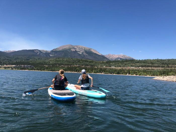
After a slow start to the year, a series of snowstorms boosted the snowpack, supporting recreation on Denver Water’s reservoirs, including paddleboarding on Dillon Reservoir, throughout the summer. Photo credit: Denver Water.
And a tough summer awaited. Denver Water’s records put the summer of 2024 as the fifth-hottest in the region. And precipitation was weak, ranking fourth worst in the utility’s service area.
But after that slow start, the snowpack rallied. Big snows occurred in late January, followed by normal snows in February and a big March storm that pushed snowpack numbers up, especially in the North Fork of the South Platte River.
Then, in a big surprise, the storms kept coming. Not only in April but in May, also, weeks beyond the point snowpack typically stops building.
More good news followed. Spring soil moisture was in good shape, so water stayed in streams and filled reservoirs instead of soaking into bone-dry ground, a frequent problem in recent years.
Then, customers did their part, largely adhering to watering rules that kept water use stable even amid such a hot and dry summer.
Daily use in Denver Water’s service area never soared above average and total summer demand from customers hewed close to normal.
“Customers continue to understand the basics: Don’t water in the heat of the day, turn off your irrigation after rainstorms. Keep your watering to two or, at most, three days a week,” said Nathan Elder, Denver Water’s manager of water supplies.
More customers are remodeling their yards and replacing water-needy Kentucky bluegrass with water-wise ColoradoScapes like this one that thrives in our semi-arid climate. Photo credit: Denver Water.
For Elder, the success story of the 2024 water year was how well Denver Water was able to manage its system to maximize flows for recreation and the environment.
Healthy supplies meant more water releases from Dillon that bolstered rafting in the Blue River. Good supplies also helped support rafting on the North Fork for the annual BaileyFest event. It also kept reservoir elevations high for flatwater recreation, such as boating and paddleboarding.
It also allowed releases to help aquatic environments, such as keeping stream temperatures in a safe range for fish in the Fraser River and providing flushing flows to improve fish habitat on the South Platte.
Supplies also helped ensure Denver Water could provide water downstream on the Colorado River to support endangered fish above Grand Junction.
“After a nerve-wracking start, the water year improved in a hurry,” Elder said. “Full reservoirs and good runoff give us the flexibility to move water around in a way that helps a lot of interests while serving our customers.”
Now, as the new water year kicks off, the watch for precipitation begins.
And we enter the new water year with good news: Denver Water reservoirs begin the 2024-25 water year with good supplies. But a dry summer in the region has left dry, thirstier soils that could drink up melting snow next spring. That could make 2025 trickier.
The wait, and watch, is on.
With the 2023-24 water year now in the books, Denver Water’s planners are eyeing the weather patterns to see what the winter storms will bring. Mountain snowpack, captured and stored in mountain reservoirs such as Strontia Springs (pictured) supplies most of Denver’s water. Photo credit: Denver Water.
Santiago Maestas, president of the South Valley Regional Association of Acequias, stands next to the Pajarito acequia in Albuquerque, New Mexico. Visual: Lourdes Medrano for Undark
Santiago Maestas has grown apples, peaches, and apricots on his New Mexico property for more than five decades. He still cherishes the network of ancient gravity-fed irrigation ditches that deliver the water that keeps his orchard thriving.
Those irrigation ditches, scattered across the state and known as acequias (pronounced ah-SEH-kee-ahs), have endured for hundreds of years. For Maestas and other residents in Albuquerque’s South Valley, the communal irrigation system is an integral part of life in one of the country’s most arid regions.
“It’s what makes the valley green,” said Maestas, walking along a narrow, meandering acequia near his house on a summer morning. “It provides us with a canopy. It provides us with the ability to continue to grow crops in our backyards.”
The water that day flowed through the canal, flirting with the roots of lush, towering trees lining the dirt banks that Maestas strolled. In a small ditch, the gravel bed was dry and covered in weeds, a sight emblematic of dwindling water. Scientists say a lingering drought, warmer springs, and reduced water flow in the Rio Grande will intensify and further test the ancient irrigation systems.
Acequia users like Maestas are part of a collaboratively managed irrigation system that delivers water from ditches to crops and gardens. To cope with an increasingly dry environment, irrigators are already making some adjustments to the waterflow. “We’re now on a three-week rotation,” he said. “One day every three weeks, we can deliver water. Earlier in the spring, when the river was full, we could deliver water every two weeks.”
Acequia users say the treatment of water as a commodity that can be sold and traded, like gold and silver, goes against the traditional system, which emphasizes shared resources.
As water becomes increasingly scarce in the drought-stricken Southwest, so does competition for the resource. This worries users of New Mexico’s acequias, which research shows could help offset some effects of climate change as water seeps into the soil, replenishing groundwater that helps balance the water supply during scant rainfall. To safeguard their unique system, irrigators like Maestas are working on adapting to volatile weather, boosting acequias as a sustainable resource, and strengthening legal protections around water rights in a changing environment.
Acequia users say the ever-increasing treatment of water as a commodity that can be sold and traded, like gold and silver, goes against the traditional system, which emphasizes shared resources. The canals that have long sustained people still exist because of their communal bonds and deep connection to land and water, said Jorge Garcia, a South Valley resident. Acequias are a “system that carries not only our history, but also our spiritual values.”
In a water-stressed place like New Mexico, Garcia said, preserving acequias can ensure a continued supply of clean water for those who depend on it to grow food for their families and for the local community: “We have to protect the water that we have for future generations.”
The use of shared canals and ditches to irrigate New Mexico date to before the arrival of Spanish explorers in late 1500s. When Spanish explorers arrived and expanded their occupation from Mexico into what is now the American Southwest, they built the system of acequias that could deliver water to their established settlements.
“There’s a distinction between an acequia and a canal and a ditch,” said José Rivera, a research scholar who has long studied acequia culture. “Acequia has a connotation about it that it’s both a physical system, just like a canal or just like a ditch. But acequia also means it’s a social organization of irrigators. It’s a community of irrigators.”
In other words, acequias refer both to the physical structure and the social institution that governs its use. The irrigation system relies on a network of canals that deliver water from rivers, streams, and springs. Gates open and close so the water can flow into smaller ditches that allow irrigators, also known as parciantes, to flood their land during the growing season. Each acequia functions as a democratic institution that shares water fairly during shortages. A mayordomo, or ditch boss, handles various tasks, including organizing the people, to keep the acequia running smoothly. Three commissioners, or comisionados, provide oversight.
Acequias are a “system that carries not only our history, but also our spiritual values.”
Rivera calls acequias in New Mexico “an amalgamation of all of these practices and all of these traditions and they came together here.” ( Spaniards inherited the practice, which has Middle Eastern roots, during the Moorish rule in Spain.) According to the New Mexico Acequia Association, today the state has about 700 acequias considered political subdivisions subject to state laws. Meanwhile, neighboring Colorado has around 70 along its southernmost region. Acequias built in other Southwest regions, such as Arizona, before the United States became a nation have long disappeared.
Acequias in New Mexico for the most part still adhere to traditions stemming from old Spanish and Mexican legal systems that emphasize shared benefits and responsibilities, as well as unique Spanish terminology, said Rivera, professor emeritus of community and regional planning at the University of New Mexico.
The historic waterways crisscross urban and rural land, distributing water to thirsty orchards, gardens, and small fields. “Ultimately, the way that we use these resources is what has allowed our communities to survive for all these generations,” said Patrick Jaramillo, co-director of the New Mexico Program of the American Friends Service Committee in Albuquerque.
His nonprofit collaborates with those working to protect acequia traditions. “The acequieros, or the stewards here know that if we keep these practices, our communities will continue,” said Jaramillo, who grew up on an acequia property.
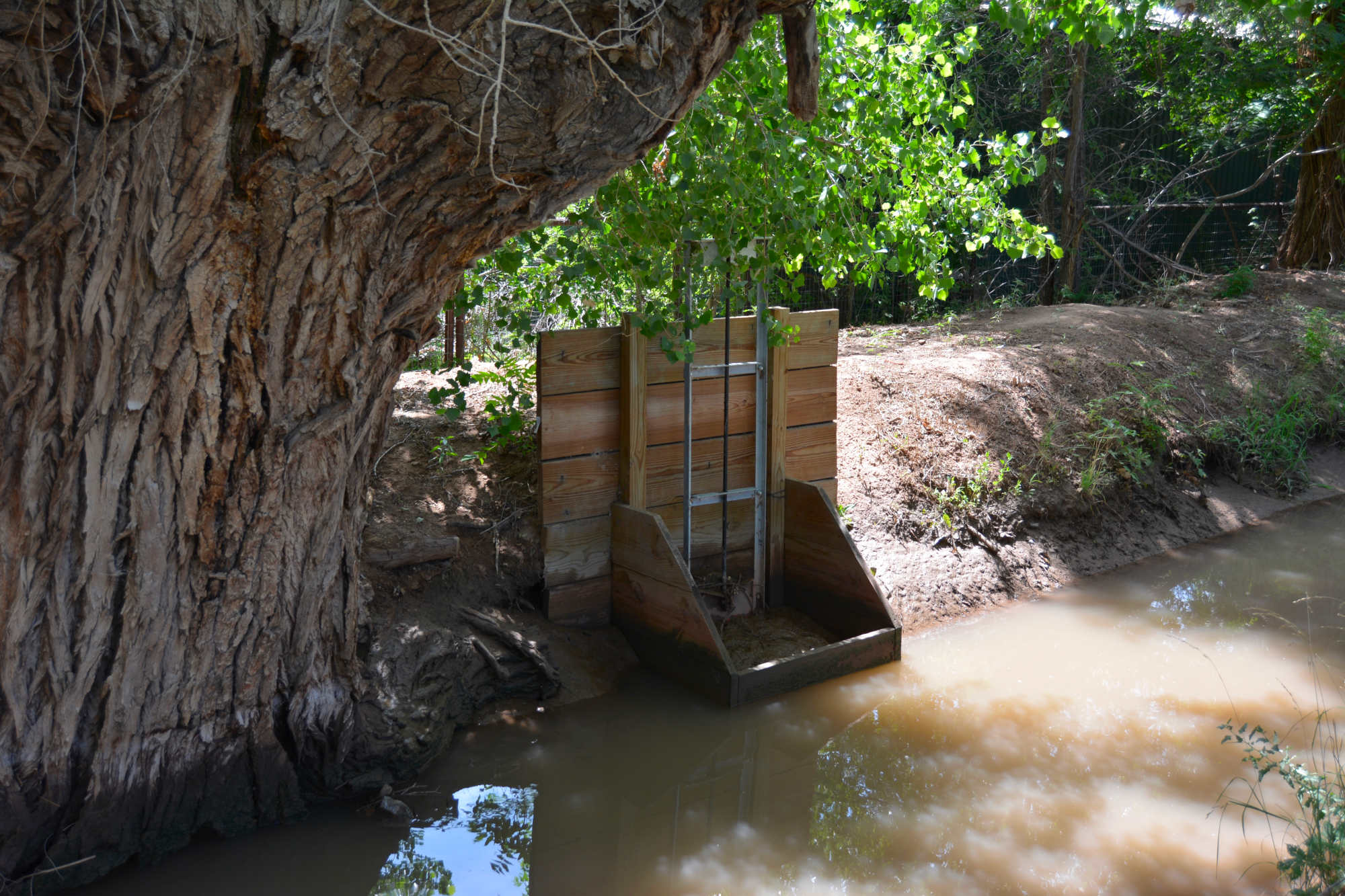
Gates control the flow of water into smaller ditches, providing irrigators with water to flood their land during the growing season. Visual: Lourdes Medrano for Undark
Although the antiquity of acequias affords them certain legal protections, their endurance has not been without struggle. The growth of water users and changing laws that champion water rights as individual property have meant frequent clashes with the communal concept of acequias.
In the early days of modern southwestern settlement, acequia water could not be legally diverted from ditches. Now, parciantes can sell their rights to their share of water even if they keep their land.
“In the past, water rights could not be transferred outside of the community,” Rivera said. “Now they can. They’re bought and sold, like any kind of property. So that’s a major threat.”
Acequias increasingly defend their way of life through political activism. They’ve adopted bylaws as acequia associations to restore governance abilities as owners of some of the state’s oldest water rights. Although parciantes have individual water rights, the irrigation system itself is owned and managed collectively as a common property, Rivera said.
Acequia communities have the right to protest proposed water transfers they deem could be detrimental to the function of their system. According to the Acequia Governance Handbook, acequia associations that have not adopted transfer bylaws that give them rights can express concerns in public hearings, but the New Mexico Office of the State Engineer, which regulates water rights, has the final word.
“We have to protect the water that we have for future generations.”
A water transfer diverts water destined for an acequia to a new location, for example. The practice sometimes pits parciantes against parciantes. In the South Valley, people seek water transfers for economic reasons, because they’re moving, or simply because they have no need to irrigate, Garcia said.
One of the South Valley acequias is now protesting a parciante’s plan to sell and transfer water rights to a cannabis farm. Protesters argue that the sell-off of too many water rights from an acequia could eventually lead to its collapse. Parciantes also have opposed proposed high-density development they say would impair water resources, including acequias.
Garcia adamantly opposes any development that could jeopardize water rights in acequias. He feels the same about water transfers from parciantes that could deplete water flows in acequias and hurt other irrigators. “The individual right is conditioned and dependent on the collective right,” he said. “Why? Because the system is designed to function with gravity. So the more water you take, the less pressure there is, the more difficult it gets to distribute water.”
Maestas put it this way: “There’s not enough water for the city of Albuquerque and the acequias and the farmers.”
The surface water that keeps acequias flowing in the South Valley and other traditional irrigation systems across the state originates as winter snowpacks in the Rocky Mountains of southern Colorado. During spring, the snowmelt runoff from the mountainous headwaters of the Rio Grande travels south through New Mexico and then becomes the international boundary between Texas and Mexico.
The water channeled from the river into acequias has kept sustenance farming alive for generations and, over the years, allowed some growers to expand food production in their communities. But decreases in snowpacks causing diminished and variable stream flows are projected to worsen with the higher temperatures of global warming.
“The acequia communities, they’re right on the frontline of these changes,” said Caitriana Steele, an associate professor in the department of plant and environmental sciences at New Mexico State University. “They’ve got no way to store water, really. The snowpack is their storage.”
“There’s not enough water for the city of Albuquerque and the acequias and the farmers.”
There’s already evidence that the changes in temperatures are causing the snowmelt that fills acequias to happen earlier in the spring, which complicates irrigation, said Alexander “Sam” Fernald, director of the New Mexico State University’s New Mexico Water Resources Research Institute. This means depleted flows in the summer, when the demand for water soars.
“We’re already seeing reduced runoff, and we’re expecting in the near future to have up to 25 percent less runoff,” Fernald said. “We’re not there yet, but we’re already seeing less runoff for a given snowpack.”
Severe weather, including drought and wildfires, and how it could affect the ability of acequias to continue providing water for communities worries many. In 2022, flash flooding damaged several acequias in various parts of the state.
“The current drought affecting the Southwest United States is probably the worst drought in 1,200 years,” said Tom Swetnam, professor emeritus of dendrochronology at the University of Arizona in Tucson. Tree ring data shows that acequias have withstood similar dry conditions for up to 150 years.
The scientist, who now lives in the New Mexico mountains, said he’s seen firsthand the damage that wildfires can do to the traditional irrigation systems. “The acequias and the places where they’re catching the water from the rivers get filled up with sediment from post-fire erosion,” he said.
Fernald, who has long studied acequias, said their collaborative nature has factored into their survival during tough weather events over the years. Their water-sharing principles, he said, could continue to help them withstand precarious times to keep irrigating their crops.
Tree ring data shows that acequias have withstood dry conditions similar to today’s drought for up to 150 years.
Although acequias lose a good amount of water to evaporation when they soak crops and gardens through flood irrigation, studies show that their hydrology provides benefits to the environment that may actually help counter the loss. For example, Fernald’s research found that seepage — which can range from about 7 to more than 50 percent of the flow — recharges the aquifer and eventually returns to the river. “Acequias also provide many benefits for riparian habitats,” he said.
He likened acequias to beaver dams that keep the water in the upper watershed, by spreading it out over fields, and soaking it back into the groundwater. “It delays its flow downstream, so that’s actually really good for the downstream because there’s water in the river later in the summer,” Fernald said.
For Santiago Maestas, keeping the water flowing to all acequias in the South Valley and across New Mexico is paramount. He cannot fathom a day when the water won’t run down a ditch to quell the thirst of his orchard, or a neighbor’s garden, or a farmer in the northernmost reaches of the state, he said: “The acequias are the lifeblood of this area.”
The 29 square miles that make up the unincorporated South Valley community are home to about 37,600 residents, 82 percent of them Hispanic. Families who have lived on land-grant acequia properties for generations mingle with neighbors who have moved in throughout the years and adopted their communal irrigation traditions that emphasize sharing water when it’s plentiful and rationing it when it’s meager.
In 1973, Maestas moved into his South Valley half-acre property, which included an acequia that carried water to the alfalfa he grew. But the death of the mayordomo left the ditch unattended. It later fell into disrepair, which left Maestas without access to water. Looking for a way to irrigate again, Maestas went on a mission to unlock the time-honored intricacies of the acequia system.
After attending workshops and poring over books on water laws and policy, Maestas discovered that his property came with pre-1907 water rights. That year produced the water code that gives the state the power to control water use and protects water rights established before the date. Such rights are the only ones that can be used without state approval.
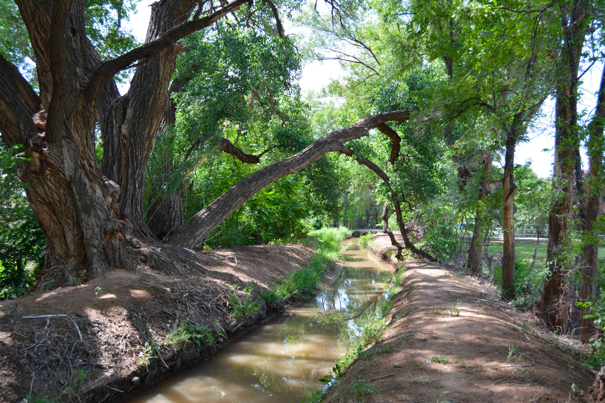
Lush greenery surrounds an acequia in the South Valley. Research has shown that acequias can help recharge aquifers, and they also provide many benefits for riparian habitats. “The acequias are the lifeblood of this area,” said Santiago Maestas. Visual: Lourdes Medrano for Undark
Maestas set out to regain water access and inform longstanding acequia users that claiming pre-1907 water rights leaves no doubt of legal standing as competition for water intensifies. Many South Valley residents were, and still are, unfamiliar with a benefit they may have, he said. That’s something Maestas, now as president of the South Valley Regional Association of Acequias, works to change.
Acequias in the South Valley dealt with significant disruption when the Middle Rio Grande Conservancy District created in the 1920s eventually took charge of surface water in the region. Unable to pay the quasi-public agency’s required taxes for new drains, canals, and other infrastructure, acequia associations faltered amid the changes.
Nonetheless, they never ceased to function as a group of parciantes working for the common good, said Garcia, who also is the executive director of the nonprofit Center for Social Sustainable Systems. He and Maestas have worked for years to revitalize acequias and promote understanding in the values and practices of the longstanding institutions.
The two men and other acequia advocates gather once a month at a local waterway with area residents interested in learning about the agricultural tradition and ongoing efforts to preserve them. In July, a group listened to Maestas talk about the history of the five ancient acequias that run through the South Valley.
“The whole irrigation system in the South Valley starts here,” Maestas told a circle of people standing in the shade of two imposing cottonwoods on a late morning. In the distance, a thicket of trees tinted the landscape yellow green.
In the past, Maestas said, the spring runoff that feeds the Rio Grande would wash out the earthen ditches and irrigators had to rebuild them every year. “In many parts of the valley here, the river is actually higher than the valley.”
These days, levees built by the conservancy district keep the river from overflowing into the valley. “So they’re critical and they require federal money because it takes millions of dollars to construct these — more than whatever we could pay with our property tax fees and our water service fees,” Maestas said.
“Without water, we’re not going to be here. And that is something that we’re going to have to reckon with very, very soon.”
Among those listening were about a dozen kids who arrived on bikes. They were part of Story Riders, a bicycling program that offers cultural and environmental education for youth. The group was riding along the acequias daily, documenting the status of South Valley ditches in a report they planned to share with the conservancy district, said program manager Marco Sandoval.
The program works to connect youths with New Mexican culture and acequias are a significant part of it, Sandoval said. “Water is an important issue here,” he added. “Without water, we’re not going to be here. And that is something that we’re going to have to reckon with very, very soon.” Today’s youths could one day help preserve acequias as a sustainable system that can still grow crops and help improve food security in a harsher environment, Garcia said, and with the effects of climate change expected to worsen, “the right thing to do is to get closer to natural systems and acequias give us that opportunity.”
In the meantime, Maestas expects to keep doing his part to protect acequias. “Basically, this is our legacy,” he said. “It’s our role now to be the stewards of the acequias.”
This story was supported in part by The Water Desk at the University of Colorado Boulder’s Center for Environmental Journalism.
Click the link to read the report on the NOAA website (Gretel Follingstad, Amanda Sheffield, Kelsey Satalino, Eleanor Hasenbeck, Dave Simeral, Erinanne Saffell, Peter Goble, Jon Meyer, Michael Natoli, Andrew Mangham, Paul Miller, Mike Crimmins, Dave DuBois, Laura Haskell):
Key Points
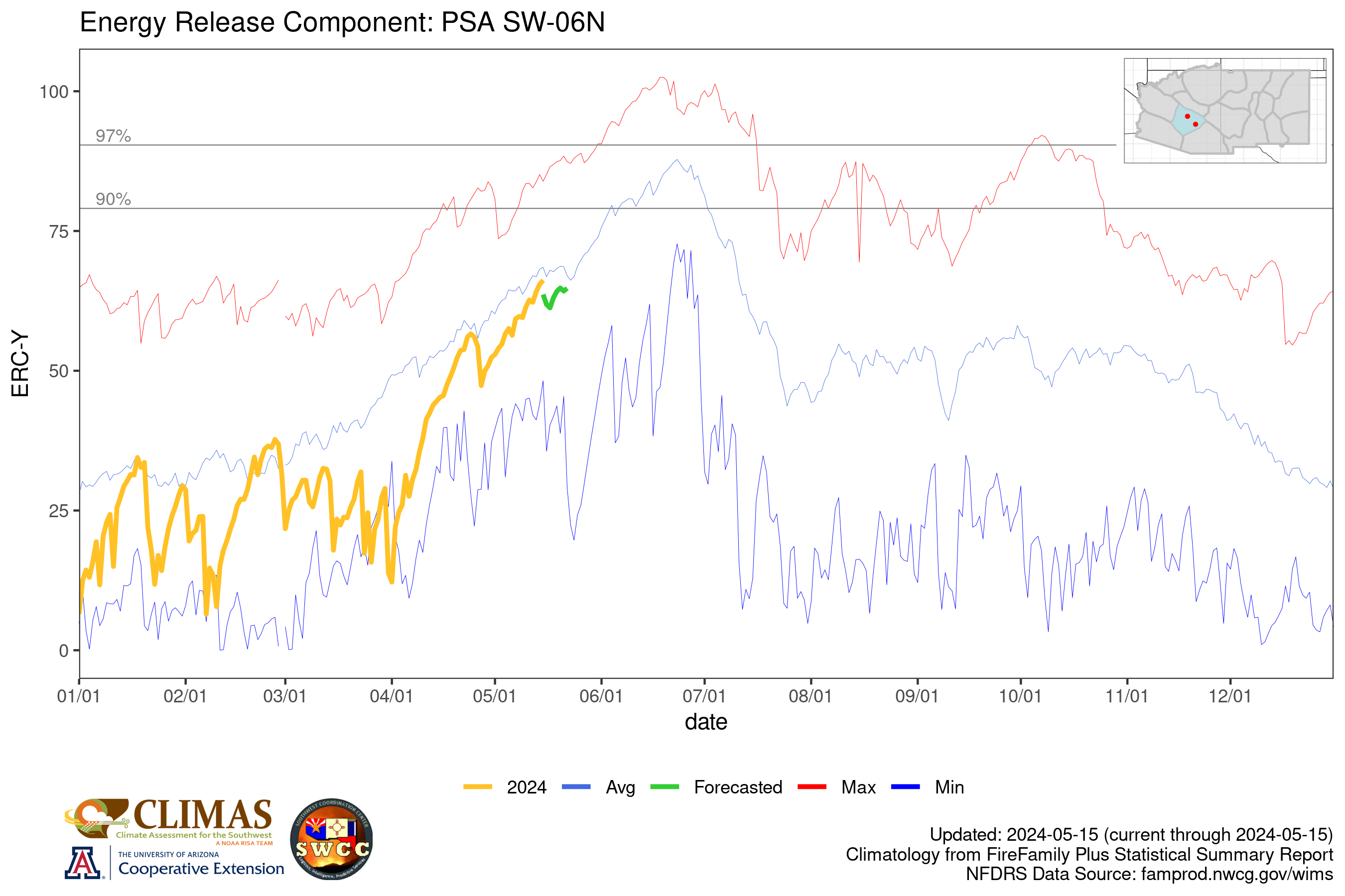
Water Year 2024 overall was warmer than normal across the Intermountain West, with variable precipitation across the region, contributing to drought development in Wyoming and limiting drought amelioration in southern New Mexico.
Drier-than normal-conditions were noted in northwestern Arizona, southern New Mexico, western and southwestern Utah, north-central and southeastern Colorado, and eastern and southern Wyoming.
Wetter-than-normal conditions were logged in northern portions of New Mexico, much of the southern Rockies of Colorado, areas of central and west-central Utah, and parts of northwestern Wyoming.
Overall, the 2024 North American Monsoon season precipitation underperformed in Arizona and southern/western New Mexico and overperformed in eastern and northern Utah, northern New Mexico, and all but the Front Range and eastern Rockies of Colorado.
As of October 7, 2024, El Niño-Southern Oscillation (ENSO) neutral conditions are expected to transition to La Niña by November (71% chance), which typically increases likelihood of drier winter conditions across the Southwest, and is expected to persist through January–March 2025.
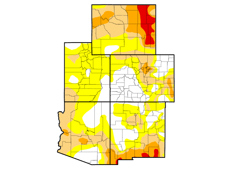
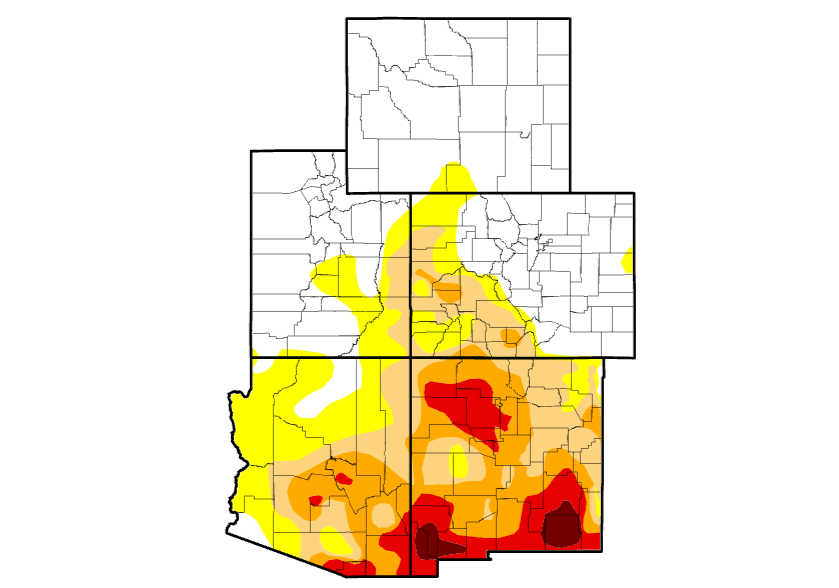
Intermountain West Drought Monitor end of water year 2024.
Intermountain West Drought Monitor beginning of water year 2024.
Intermountain West Water Year 2024 Summary
Water Year 2024 (October 1, 2023–September 30, 2024) included a mixed bag of record-breaking temperatures, precipitation anomalies, and both drought development and improvement in the Intermountain West.
Drought developed in Wyoming and improved in parts of New Mexico, Arizona, and Colorado. Long-term drought impacts remain in many areas of the region, including persistent drought in southern New Mexico, despite normal to above-normal precipitation in many areas.
Roughly the same percentage of the Intermountain West was in drought at the start of Water Year 2024 (38.27%), as the start of Water Year 2025, October 1, 2024 (36.55%). However, drought conditions shifted across the region. At the onset of Water Year 2024, 94.86% of New Mexico was in Moderate to Exceptional Drought (D1–D4) and 0.0% of Wyoming was in drought. Drought has increased in Wyoming to 71.33% and improved in northern/central New Mexico (now covering only 34.73% of the state), eastern Arizona, and southwestern Colorado.
Most of the Intermountain West experienced average- to above-average snowpack over the course of Water Year 2024. However, snow drought persisted throughout winter in much of northern Wyoming, with record-low snow water equivalent at several long-term SNOTEL stations.
The 2024 North American Monsoon cumulatively delivered an underperforming season of precipitation for Arizona and southern/western New Mexico, while overperforming in eastern Utah, northern New Mexico, and all but the front range and eastern Rockies of Colorado, improving drought conditions in many areas.
Colorado received 95% of normal precipitation for Water Year 2024, but areas were both much wetter than normal and much drier than normal. In Colorado, Monte Vista in the San Luis Valley recorded its wettest water year on record (since 1944) with 14.56 inches of precipitation.
New Mexico statewide precipitation was 87% of average. Southern New Mexico was below average, and Las Cruces reported its driest water year on record with just 3.32 inches recorded.
Utah experienced record rainfall totals in the southeast (parts of Emery, Wayne, and Garfield counties), which coincided with an eastern shift of the monsoon pattern.
Above-normal temperatures impacted the entire Intermountain West region, which contributed to new drought development in Wyoming, Arizona, and eastern Colorado and long-term drought persistence in southern New Mexico.
Arizona experienced its hottest summer (June–August) on record (130 years).
Colorado experienced its 7th warmest water year on record, and its 5th warmest June–September. Grand Junction recorded its warmest summer on record, and eastern Colorado, including Kiowa, Bent, and Prowers Counties, continues to suffer from Severe Drought (D2).
New Mexico had its 5th warmest water year and 3rd warmest summer (June–August) on record.
Figure 1: Intermountain West Water Year 2024 Drought Change Map: October 3, 2023–October 1, 2024
Key takeaway: In Water Year 2024, Wyoming experienced significant drought development, with a 3-4 category drought degradation (going from 0% of the state in drought to 71.33%). Much of New Mexico experienced notable drought recovery.
52-week U.S. Drought Monitor change map, showing where drought has improved (green), is unchanged (gray), or has worsened (yellow to orange) from October 3, 2023–October 1, 2024. Source: National Drought Mitigation Center.
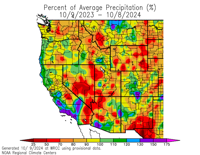
Figure 2: Percent of Average Precipitation: Water Year 2024
Key takeaway: Water Year 2024 was drier than normal across northwestern Arizona, southern New Mexico, western and southwestern Utah, north-central and southeastern Colorado, and eastern and southern Wyoming. Northern portions of New Mexico, much of the southern Rockies of Colorado, areas of central and west-central Utah, and parts of northwestern Wyoming saw wetter-than-normal conditions.
Percent of normal precipitation for Water Year 2024 (October 1, 2023–September 30, 2024), compared to historical conditions from XXXXXX. Red and orange hues indicate below-normal precipitation, yellow to light green hues indicate near-normal precipitation, and dark green, blue, and purple hues indicate above-normal precipitation. Valid October 9, 2024. Source: Western Regional Climate Center.
Figure 3: Water Year 2024 Mean Temperature Departure (°F) from Normal for the Western U.S.
Key takeaway: The entire Western U.S. experienced above- and much-above-normal mean temperatures this water year, with record warm temperatures in several locations across the region. In much of the Intermountain West, mean temperatures for the water year were between 1–4º F above normal.
Departure from normal mean temperatures (°F) across the western U.S. for Water Year 2024 (October 1, 2023–September 30, 2024), compared to historical conditions from 1981–2010. Source: Western Regional Climate Center, WestWide Drought Tracker, using PRISM data.
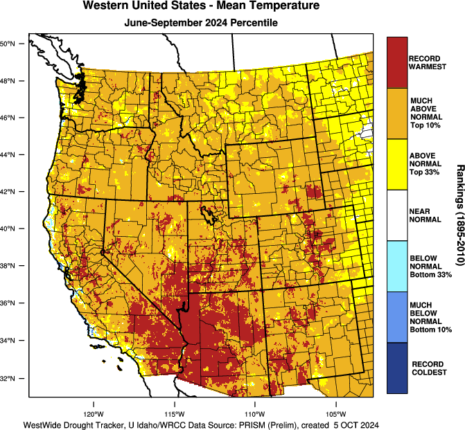
Figure 4: Summer 2024 Mean Temperature Rankings for the Western U.S.
Key takeaway: Summer 2024 saw record warm temperatures in many areas of Arizona, New Mexico, eastern Colorado, southwestern Utah, and southeastern Wyoming, compared to 1895–2010.
Mean temperature rankings (percentiles) across the western U.S. for June–September 2024, compared to historical conditions from 1895–2010. Blue hues indicate below-normal temperatures, yellow and orange indicate above-normal temperatures, and red indicates record warm temperatures. Source: Western Regional Climate Center, WestWide Drought Tracker, using PRISM data.
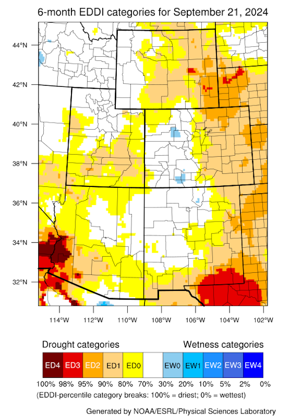
Figure 5: 6-Month Evaporative Demand Drought Index (EDDI): September 1, 2024
Key takeaway: Impacts of high spring and summer temperatures are evident in the Evaporative Demand Drought Index (EDDI), notably in southeastern Wyoming, southwestern Arizona, and southeastern New Mexico. Despite normal or above-normal precipitation, high evaporative demand (the “thirst” of the atmosphere) kept drought recovery to a minimum.
The Evaporative Demand Drought Index (EDDI) is a drought monitoring tool that shows the anomaly in daily evaporative demand (“the thirst of the atmosphere”) over a given period time. Unusually high evaporative demand can lead to moisture stress on the land surface, and ultimately to drought—even when precipitation has been near-normal. This map represents evaporative demand over the 6 months leading up to September 21, 2024 across the Intermountain West. Source: NOAA Physical Sciences Laboratory. Map from Dave Simeral.
2024 Water Year Drought Impacts
Wyoming degraded, from no drought a year ago to 71% of the state as of October 1, 2024. The worst agricultural impacts are in the northeastern corner of the state, where poor rangeland conditions, reduced crop yields, reduced irrigation water, water hauling for livestock, supplemental feeding, decreased stock weights, and dry creeks/stock ponds were reported.
Central Utah and east-central and southern Colorado also reported agricultural and rangeland impacts with lack of forage production and dry soils impacting planting winter wheat requiring drilling into the ground in some fields.
High temperatures affected water supply, irrigation, and hydropower generation. Warm temperatures reduced snowpack accumulation, produced an earlier snowmelt-driven run-off, and negatively impacted associated water management decisions for communities and land managers (e.g., agriculture, ranches, public lands) over the summer months.
Lake Powell and Lake Mead maintain well-below-normal storage levels compared to long-term averages.
Drought impacted wildfire activity in Utah, Wyoming, and Arizona. Grassland growth in low elevations in Arizona was high due to wet conditions in winter 2024, which led to a 60% increase in acreage impacted by wildland fire, exacerbated by low summer precipitation in the lower desert areas.
Reservoir Levels Across the Intermountain West
Over Water Year 2024, reservoir storage increased in Lake Powell, though it is still below average. Other reservoirs hit historic lows.
As of June 2024, in the Upper Colorado River Basin, the U.S. Bureau of Reclamation reported reservoir levels for Flaming Gorge at 87% full, Blue Mesa at 63% full, and Navajo at 72% full. Lake Powell was 37% full. Unregulated inflow into Lake Powell for the April–July runoff period was approximately 5.32 million acre-feet (MAF), or 83% of average. As of October 4, 2024, Lake Powell was at 60.4% of average levels for this time of year.
After the irrigation season ended on the lower Rio Grande in New Mexico, Caballo Dam was shut off (September 28), and water releases from the Elephant Butte dam ended on September 26, 2024. Elephant Butte is currently 6% full (13.2% of average storage for this time of year).
Figure 6: October 2024 Reservoir Storage Levels
Key Takeaway: Lake Powell storage improved over the course of Water Year 2024, while Lake Mead (Colorado River) and Elephant Butte (Rio Grande) are both at historical lows.
What Is the North American Monsoon? Why Does It Matter?
The North American Monsoon is a seasonal circulation of subtropical moisture that develops over northern Mexico and extends into the Southwest U.S. from June 15–-September 30. Monsoonal surges can occur north and west of these “core” areas, reaching Nevada, southeastern California, and Wyoming, including the Greater Yellowstone Region. Monsoonal rainfall accounts for nearly 50% of the total annual precipitation across much of Arizona and New Mexico. Learn more about the North American Monsoon.
How Did the 2024 North American Monsoon Impact Drought in the Intermountain West?
Pre-Monsoon Conditions:
As of June 4, 2024, drought conditions were most severe in southern New Mexico, with areas experiencing drought in Arizona, Colorado, New Mexico, Utah, and Wyoming.
Following a strong El Niño winter (with normal to above-normal snowpack for most of the region), a climate pattern that resembled the monsoon developed in June and July, caused by unusually high thunderstorm activity in the southwestern Atlantic Ocean, Caribbean, and Gulf of Mexico. This resulted in an increase in near-surface Gulf moisture and increased winds from the two jet streams, and facilitated better organization of thunderstorms (which were not a monsoon pattern).
The August- September precipitation was a traditional North American Monsoon pattern (south to north steering flow similar to the 2016 monsoon), which brought average to above-average precipitation for some of the southwestern U.S., including the four corners region, areas of northern New Mexico, southeastern Arizona and southwestern Colorado.
Prior to the 2024 Monsoon season, all five Intermountain West states were experiencing some level of drought. As of June 4, 2024 the U.S. Drought Monitor reported that 20.02% of Arizona, 72.41% of New Mexico, 12.89% of Colorado, 6.17% of Wyoming, and 0.40% of Utah were in drought.
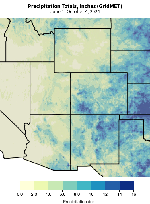
The highest monsoon seasonal precipitation totals were in northern New Mexico (between 90%-150% of normal) and the Four Corners region.
State-by-State Summary:
New Mexico: Monsoon precipitation was below normal in southern New Mexico (25% of normal monsoon precipitation) and the southwestern climate district (30th driest monsoon season). However, the northeastern climate district had its 29th wettest monsoon, which improved drought in some areas of New Mexico. Statewide precipitation in New Mexico ranked 65th driest between June-September.
Arizona: Areas of western and central Arizona had an underperforming monsoon season. Phoenix experienced 30% of normal monsoon season precipitation, while Tucson was at 101% of normal precipitation.
Colorado: Areas of southern and western Colorado received normal to above-normal precipitation. The eastern plains received below-normal precipitation.
Utah: Statewide, Utah cumulatively experienced well-above normal rainfall. but July precipitation conditions were well-below average with several counties in east central Utah experiencing record dry rainfall totals, followed by record wet August precipitation. Though short-term drought conditions impacting agriculture and rural communities worsened, healthy soil moisture and reservoir levels demonstrate gradual hydrologic drought improvement.
Wyoming: Wyoming was largely very dry through the 2024 Monsoon Season, outside of a wet August in the far southeast part of the state. Less than 50% of normal precipitation fell in parts of central and northeast Wyoming, leading to rapid expansion of drought. As of October 1, 2024, 71% of the state was in drought, with 12% of the state in Extreme Drought (D3).
Key takeaway: Favorable monsoon seasonal precipitation fell in northern New Mexico, southeastern Arizona, and southwestern Colorado.
June 1–October 4, 2024 precipitation totals (inches) across the Intermountain West. Source: GridMET via Climate Engine. View an interactive version of this map.
Did the El Niño–Southern Oscillation (ENSO) Neutral Conditions Impact the 2024 North American Monsoon?
The relationship between the monsoon and El Niño/La Niña events is hard to predict, though there is evidence of a correlation. Several physical mechanisms link wet winters in the monsoonal region during El Niño years with high spring soil moisture that delays the monsoonal onset. However, the extreme year-to-year variability inherent to monsoonal activity limits the statistical ability to anticipate ENSO conditions with summer precipitation outlooks, where seasonal conditions are often driven primarily by event-level weather patterns.
Winter 2023–2024’s El Niño conditions brought normal to above-normal snowpack for much of the region, including Utah, Colorado, and northern New Mexico.
Some research suggests summers with La Niña conditions tend to favor robust monsoon activity in June and July, and summers with El Niño conditions tend to favor less active monsoons, but wetter winter precipitation.
Summer and early fall 2024 were ENSO-neutral. ENSO-neutral conditions can result in strong or weak monsoon precipitation for the Southwest and Four Corners areas.
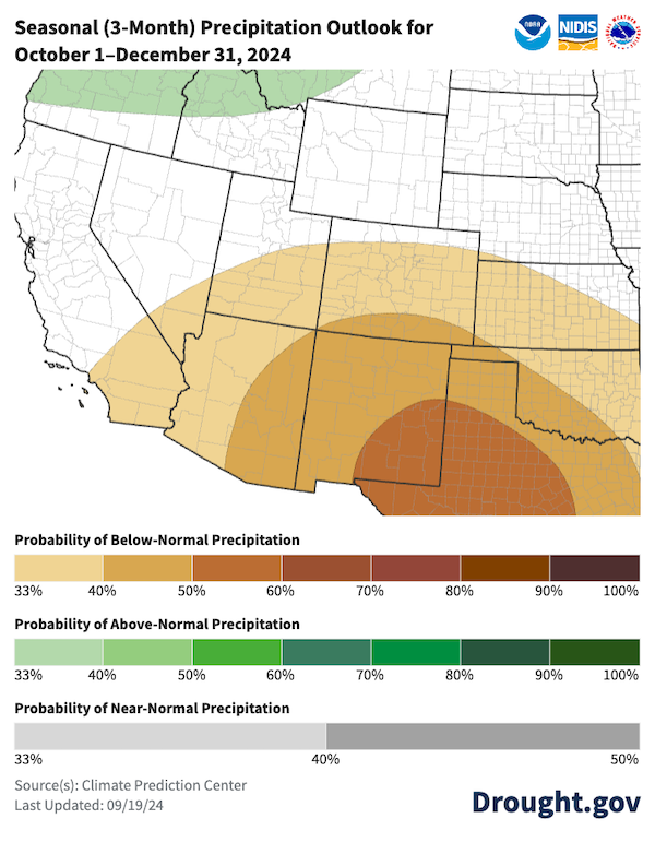
Odds favor below-normal precipitation for October–December 2024, while temperatures are more likely to be above normal, increasing chances for drought degradation in the region.
Figure 8: Seasonal Precipitation and Temperature Outlooks (October–December 2024)
Key takeaway: According to NOAA’s Climate Prediction Center, odds favor both below-average precipitation and above-average temperatures across the Intermountain West, southern California, and southern Nevada from October–December 2024.
The probability (percent chance) of above-normal (green hues), near-normal (gray hues), or below-normal (brown hues) precipitation from October–December 2024. Map from Drought.gov
The probability of above-normal (red hues), near-normal (gray hues), and below-normal (blue hues) temperatures for October–December 2024. White areas indicate equal chances of above-, near-, or below-normal conditions. Source: NOAA’s Climate Prediction Center. Map from Drought.gov
It was one of nearly two dozen conventional mills in the U.S. when it opened in 1980, just south of Blanding, and it’s now far past its projected 15-year lifespan. Demand for uranium fell — aside from some spikes — over the decades, and mill owner Energy Fuels pivoted to also processing leftover radioactive materials from other countries, rare earth elements and producing medical isotopes. But with the growing global push for clean energy and recent international instability, demand has skyrocketed for the “yellowcake” that the mill creates. Uranium averaged about $40 a pound in 2022. It reached over $100 per pound in January and is valued at $80 per pound today, according to Business Insider…
Here’s what the mill does, and why it’s controversial…The mill currently accepts uranium ore trucked from two mines also owned by Energy Fuels: the La Sal Mines Complex near La Sal, Utah, and the Pinyon Plain Mine, located in the Kaibab National Forest near the south rim of the Grand Canyon in Arizona. Here’s what the mill does, and why it’s controversial…The mill currently accepts uranium ore trucked from two mines also owned by Energy Fuels: the La Sal Mines Complex near La Sal, Utah, and the Pinyon Plain Mine, located in the Kaibab National Forest near the south rim of the Grand Canyon in Arizona. After uranium ore and other materials arrive at the mill site, they’re organized by type into separate piles to await processing.
Death by a thousand cuts: Global threats to insect diversity. Stressors from 10 o’clock to 3 o’clock anchor to climate change. Featured insects: Regal fritillary (Speyeria idalia) (Center), rusty patched bumble bee (Bombus affinis) (Center Right), and Puritan tiger beetle (Cicindela puritana) (Bottom). Each is an imperiled insect that represents a larger lineage that includes many International Union for Conservation of Nature “red list” species (i.e., globally extinct, endangered, and threatened species). Illustration: Virginia R. Wagner (artist).
by John R. Platt, The Revelator October 4, 2024
This past May, as the world started to emerge from the restraints of the COVID-19 epidemic, a paper in the journal Nature warned that future pandemics were coming, due to climate change, chemical pollution, invasive species and other factors.
The most likely cause of future outbreaks, the researchers found, could come from a threat we don’t talk about enough: biodiversity loss.
The threat of emerging pandemics will be even greater, according to the paper, when these factors combine. “For example,” the authors wrote, “climate change and chemical pollution can cause habitat loss and change, which in turn can cause biodiversity loss and facilitate species introductions.”
It’s a warning that science writer David Quammen, author of the award-winning 2012 book Spillover, has been sounding for years.
As he said on a panel at the 2023 Society of Environmental Journalists conference in Boise, Idaho, the threats of extinction, climate change and emerging diseases are “three big, brown, churning, murky rivers of woe, with some channels interconnecting now, but flowing parallel, independently to a great degree, but coming from the same source, … the human footprint.”
Connecting the Dots
Quammen has been writing about the extinction crisis since 1981, initially as a columnist for Outside magazine.
Since then his work for National Geographic and other publications, as well as his many books, has taken him all over the world. He’s written about emerging diseases, including HIV and COVID-19, as well as climate change and other threats.
And he encourages other journalists and people working in environmental fields to do a better job connecting the dots.
“When many journalists and activists talk about climate change, they tend to think that this is the big, all-encompassing problem and everything else is a subcategory,” he told me by Zoom from his book-lined home office in Bozeman, Montana.
“It’s important for people to understand: We do not have one huge problem called climate change, in which all other problems are subsets. We have three coequal problems that need to be understood fully in their severity and in their independence as well as their interconnectedness. Those are climate change, loss of biological diversity, and emerging pandemic threats.”
For journalists, as well as the public, that means we need to look a little deeper.
“Climate change is a problem that comes to us, right? It comes home to us. It comes to everybody,” Quammen said. “Loss of biological diversity can be happening at a distance.”
That might make the changes hard to see, especially if your vantage point doesn’t change much.
“If you go out and about, if you’re a traveling journalist as I’ve been, then you have seen with heartbreaking concreteness the loss of biological diversity over the decades. For instance, the decline in insect populations around the world, the decline in migrating songbird populations, the decline in populations of a lot of other creatures that perhaps need a particular high altitude or cold habitat, ranging from bumblebees to polar bears.”
Seeing these species, seeing these places, offers journalists an opportunity to illustrate to readers how these major environmental issues connect and to bring them to life — and hopefully help readers feel connected to them in return.
“Connectivity is just one of the very great truths,” Quammen said. “It’s the essence of ecology and the essence of human history, which I think of as a subcategory of ecology rather than the other way around.”
Making It Real
Illustrating that connectivity is especially important when we’re writing about far-flung wildlife that people won’t encounter in Bozeman or Boise or New York City.
“Most people were never going to see a pangolin, polar bear or lowland gorilla except maybe in a zoo. My particular career and route through life have given me the opportunity to see those creatures and a lot of others in the wild. And I’ve felt that it was part of my duty, as well as my opportunity, to try and make those creatures real, at least at one remove, in the minds and the hearts of readers who will never have the same opportunity.”
That could help, for example, to provide some emotional understanding of the wildlife trade threatening all eight species of pangolin (a trade that’s been linked to the COVID-19 pandemic), or the loss of sea ice threatening polar bears.
“My job and my opportunity are to go out there as a proxy for other people,” Quammen said.
“I get to say, ‘Hey guys and gals, this is happening. Look at this creature through my eyes. This is a magnificent, appealing, complex, amazing creature. And yet look at this situation that this creature is in. It’s outrageous, it’s heartbreaking, it’s dangerous, but it’s reversible.’”
‘Golden Thread of Hope’
Despite the dangers he’s chronicled, Quammen brings a lot of humor to his work.
“I am one of those people who believes that almost nothing is too sacred for a joke to somehow enrich the contemplation of it,” he told me. “I really believe that when you write a rich piece of nonfiction, a piece of journalism about the environment, about the living world, if you can make your audience laugh and cry and think and maybe see the world in a slightly different way, that’s the goal. Because those moments are best when they come unexpectedly, and they knock the reader a little bit off balance.”
He also brings another H- word to his work, as he discussed in a recent interview with Orion, where he said hope is a duty when writing about the extinction crisis.
Sure, there’s a lot of gloom in the extinction crisis, but Quammen told me we should always be looking for solutions, or at least small bits of progress.
“I think we should all do that,” he said. “I do that in my most recent book, The Heartbeat of the Wild, where I write about some situations, some efforts, some conservation models around the world that are working pretty well, and therefore they give me hope.”
That hope, he admitted, “is sandwiched between a lot of concern and doom and pessimism.”
And, he cautioned, writing about it “should never be programmatic.”
Too many gloomy articles contain “a hopeful ski jump at the end,” Quammen said. “It’s autopilot, it’s predictable. There are other ways to lace a golden thread of hope through the narrative tapestry that you’re creating. And I think it’s important to do that.”
The Gila River Indian Community, alongside partners from the White House, Congress and the Bureau of Reclamation, celebrated the activation of the first power generated by the Western Hemisphere’s first-ever solar-over-canal project on Oct. 3, 2024. (Photos Courtesy of the Gila River Indian Community)
The Gila River Indian Community celebrated a historic milestone in its work to provide solutions for water conservation and renewable energy by activating the first-ever solar-over-canal project in the country.
“The Gila River Indian Community is proud to be at the forefront of this groundbreaking solar-over-canal project, which not only generates renewable energy but also conserves our most precious resource — water,” Gila River Indian Community Gov. Stephen Roe Lewis said in a written statement.
The project spans over 2,700 linear feet of the Casa Blanca Canal, which is located along Interstate 10 near Sacaton.
The tribe said the project represents a groundbreaking solution to the intertwined crises of energy, water and climate change, specifically addressing the unique needs of the Gila River Indian Community, the State of Arizona, the southwest region and the Colorado River Basin.
“This project builds on the work of our ancestors, who found innovative ways to harness our water and natural resources throughout the generations,” Lewis said.
The Gila River Indian Community held an event on Oct. 3 to commemorate activating the power of the solar project near Sacaton and hosted federal leadership: White House Senior Advisor and Assistant to the President Tom Perez, Bureau of Reclamation Deputy Commissioner David Palumbo and U.S. Rep. Greg Stanton.
The project is the first solar-over-canal initiative of its kind in the Western Hemisphere, according to the tribe, and it is setting a new standard for sustainable water and energy management.
“The Gila River Indian Community, known for its long-standing leadership in water conservation and irrigation innovation, continues to pave the way for cutting-edge solutions to the challenges of the 21st century,” the tribe stated.
The Casa-Blanca Canal Solar project is developed by the Pima-Maricopa Irrigation Project a department of the Gila River Indian Community and funding support from the Bureau of Reclamation.
The $5.6 million for the project came from President Joe Biden’s Investing in America Agenda. The tribe said the project was developed as part of the administration’s broader strategy to promote innovative renewable energy solutions and water conservation technologies.
“The Gila River Indian Community is a national leader in creating practical solutions to some of the most pressing environmental challenges we face today,” Perez said in a statement.
“This project serves as a model for communities across the country as the Administration continues to invest in America and work to build a sustainable, resilient future,” he added.
The tribe highlighted how the solar-over-canal project offers numerous environmental and operational benefits, including generating clean and renewable energy, reducing water evaporation from the canal, reducing maintenance requirements for the canal infrastructure, and contributing to the tribe’s goal of a carbon-neutral energy footprint.
The Gila River Indian Community announced that two additional phases of the project are planned, with funding and design work already in progress. The next phase involves work covering a larger portion of the irrigation system.
“Water savings here on Gila River Indian Community Land means savings for the entire Colorado River System – and in this drought, every acre-foot counts,” U.S. Rep. Greg Stanton said in a statement. “These projects show what’s possible with strong partnerships between the federal government, states and Tribal leaders.”
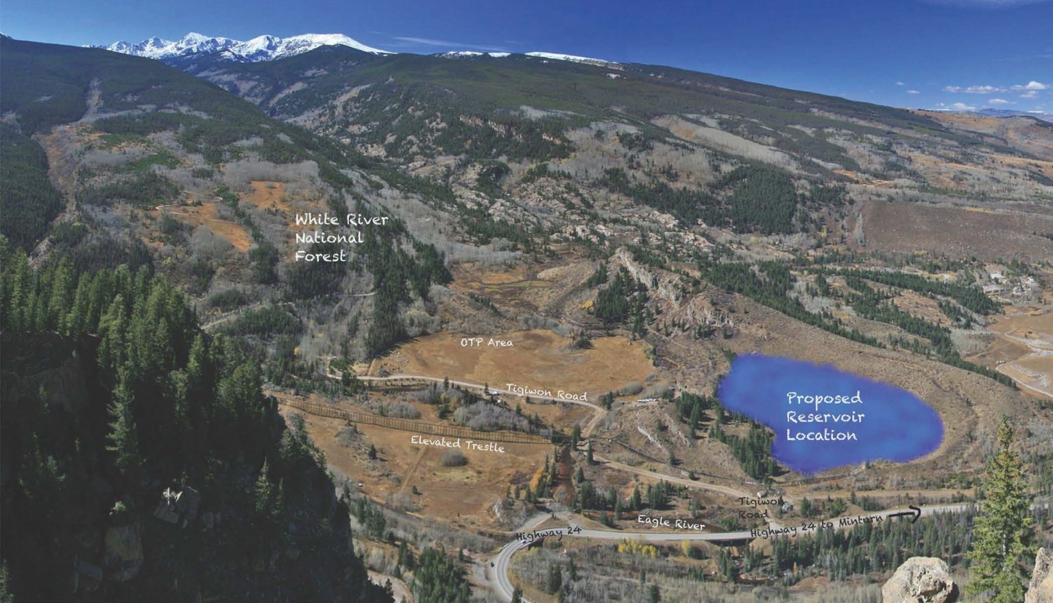
The project to create a reservoir on the Bolts Lake Reservoir site is moving forward as planned, with a tentative 2032 completion date for the potentially $100 million project. The reservoir will be located south of Minturn, on the site of the long-drained Bolts Lake. The Eagle River Water & Sanitation District and Upper Eagle Regional Water Authority boards received updates from the project leadership team during a joint meeting on Thursday, Aug. 22 and then again separately during their regular meetings on Thursday, Sept. 26. The construction engineering company Black and Veatch is serving as the project manager for the project, with Ben Johnson leading the team. Johnson presented to the boards in the August meeting…
When completed, the Bolts Lake Reservoir should hold up to 1,200 acre feet of water…to serve as additional water supply due to the risk of water supply shortage in the future. In 2020, the boards adopted a strategic reserve and system policy to guide water planning efforts and mitigate climate uncertainty.
“Our previous approach to water supply was, essentially, whatever we didn’t use in a 2002-type drought was available for new service commitments. That approach didn’t really take into account the impact of a warming climate on our available supply,” or a drought worse than 2002 or consecutive drought years, said Jason Cowles, director of engineering and water resources with the water district.
Click the link to read the release on the Reclamation website (Anna Perea and Darryl Asher):
October 1, 2024
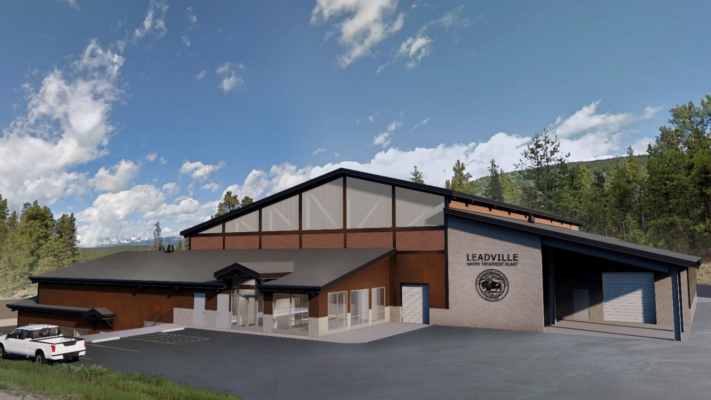
The Bureau of Reclamation awarded a contract to Oscar Renda Contracting Inc. for $131,755,000 to construct a new water treatment plant at the Leadville Mine Drainage Tunnel. This contract, partially funded by President Biden’s Investing in America agenda, funds construction of a water treatment facility with a 3.2 million gallon per day capacity, deconstruction of the existing plant, and other site upgrades.
The water treatment plant, built in 1991, has exceeded its expected service life of 30 years. Over the next several years, Reclamation will build the new water treatment plant. The new plant will have a longer life expectancy and room for growth. Engineering designs incorporated lessons learned over previous decades, emphasized safety, and improved the plant’s visual impact in the community. Reclamation has announced a total of $90 million for the project from the Bipartisan Infrastructure Law.
“The Leadville Mine Drainage Tunnel water treatment plant has done an outstanding job of serving the public and protecting downstream water quality for many decades, and we are excited to carry on that legacy with the construction of this new plant,” said Jeff Rieker, Eastern Colorado Area Office manager. “We are proud to be good stewards of the water in the much-valued Arkansas River.”
The plant removes lead, zinc, manganese, iron, and other heavy metals from contaminated water that flows from the two-mile-long Leadville Mine Drainage Tunnel. It sends 650 million gallons per year of treated, clean water to the headwaters of the Arkansas River in accordance with Environmental Protection Agency regulations. After two decades of collaborative ecosystem restoration by EPA, Reclamation, USGS, Newmont and other state, federal and local partners, the Arkansas Headwaters was named a Gold Medal Trout Stream in 2014.
Through the Bipartisan Infrastructure Law, Reclamation is investing a total of $8.3 billion over five years for water infrastructure projects, including rural water, water storage, conservation and conveyance, nature-based solutions, dam safety, water purification and reuse, and desalination.
Since the Bipartisan Infrastructure Law was signed in November 2021, Reclamation has announced more than $4.2 billion for an ever-growing list of 586 projects.
Media inquiries or general questions about Reclamation should be directed to Anna Perea, Public Affairs Specialist, at 970-290-1185 or aperea@usbr.gov. If you are deaf, hard of hearing or have a speech disability, please dial 7-1-1 to access telecommunications relay services.
An artists rendering of the new Leadville Mine Drainage Tunnel Treatment Plant. Credit: Reclamation
Click the link to read the article on the KSL.com website (Amy Joi O’Donoghue). Here’s an excerpt:
September 23, 2024
The Eagle County Conservation District will receive $994,437 over three years to expand virtual fencing for cattle grazing on Bureau of Land Management lands in Colorado. Virtual fencing — which the bureau has pioneered on public lands — is a way to improve rangeland health and drought resilience using rancher-led innovation and technology to set boundaries on grazing areas instead of physical fences, which are challenging to maintain. The foundation said that by keeping livestock contained to specific areas, virtual fences provide real-time data on the location of cattle and support active, rotational grazing to help prevent soil erosion. Virtual fencing also supports range restoration activities that improve rangeland health and drought resilience outcomes…According to the USDA’s Natural Resources Conservation Service, virtual fencing involves the absence of physical barriers to restrict cattle’s movement. The cattle wear a GPS collar that tracks movement and if a wayward animal crosses the “barrier,” it receives a series of auditory beeps to deter it from advancing. If that does not work, the animal receives a benign shock.
“Cattle have demonstrated the ability and tendency to rapidly learn the virtual fencing cues, eventually responding to the audio cue alone,” the federal agency said. “Several studies have documented success with sheep and goats as well.”
In its first year, the project will:
Expand range restoration activities on ground covered by virtual fencing, combined with monitoring of range health, to track anticipated improvements in water and soil quality.
Introduce virtual fencing and rotational grazing to Bocco Mountain in northwest Colorado, which has not been utilized by cattle in more than 30 years due to lack of fencing infrastructure.
Provide staff and equipment to scale the project to include more ranchers and bureau grazing lessees.
The first time I visited Peehee Mu’huh, mining for lithium had already begun.
I was there in the fall of 2023 as part of my work with People of Red Mountain, descendants of the Fort McDermitt Paiute-Shoshone Tribe who lead the movement against extraction on this sacred landscape. We gathered at the valley in northern Nevada, known as Thacker Pass, to commemorate the massacre of 31 Paiute-Shoshone people there by the U.S. Cavalry on Sept. 12, 1865.
Historic violence underlies the importance of Peehee Mu’huh, a site whose name means “rotten moon” in Paiute — a reference to the massacre. Yet the place’s spiritual significance to Great Basin Indigenous peoples runs deeper. They have long come here to hunt, gather food and medicine, workshop, fish, and sojourn for ceremony and family gatherings.
None of these connections were included in Tribal consultations for the Thacker Pass Lithium Mine — because, essentially, there were no consultations.
Sure, the government said it consulted the Tribes. As part of the standard environmental impact statement process — which is intended to mitigate ecological and cultural harms on Bureau of Land Management public lands — three local reservations each received a letter outlining the plans to mine lithium. Unfortunately this occurred during COVID-19 lockdowns when Tribal councils closed and many Tribal members were ill. Still, those unanswered letters were considered “input” by native community members on the 18,000-acre mine slated to produce electric vehicle batteries out of their ancestral homelands.
After that, a social movement emerged to challenge the lack of consent, affirm the significance of this space, and resist the sacrifice of Indigenous sacred landscapes to extract “energy transition minerals” like lithium — over 50% of which lie within Indigenous lands.
It was that movement that brought me to Thacker Pass.
On the first night after I arrived, the sun set to reveal a radiant orange-sorbet sky. Below our perch on the ridge, everyone could see miners scraping the surface and hear diesel trucks and engines droning ominously.
Peehee Muhuh showing early phases of mine development, September 2023 photo by Sam Orndorff
That winter I made further visits while producing a documentary with People of Red Mountain. Snow crunched underfoot as we took in the landscape changes: a pipeline siphoning water from Quinn River, electric lines, and ancillary facilities for the open-pit mine.
To picture the other major impact to come — a planned 1,300-acre waste dump — I would have to use my imagination.
Waste and the Courts
To dig up every pound of lithium, the mine will remove thousands of pounds of rock, soil, and other minerals, most of which will not be used and are considered waste.
That’s the secret of mining: It requires significant space to dump its byproducts.
Mine waste is no longer in the forefront for the environmental movement as it was when coal and nuclear power had their heyday, but it remains a key issue activists and scholars should be following. At Thacker Pass the 1,300 acres of wasteland will occupy the space indefinitely. Arsenic, antimony, and other hazards from the refining process to get lithium from the clay will pile up in this backfill pit and leach into the soils, watersheds, and air.
Efforts to handle the threat of mining waste like this seemed to improve for a brief stint a few years ago. In 2019 a federal appeals court ruled that Rosemont Copper Company, which was digging copper on U.S. Forest Service lands in Arizona, was required to prove the existence of minerals on all of the ground they covered, including an area sited for waste “tailings” dumps but under which they had not proven minerals. This would prevent them from dumping waste on nearby land not part of the actual mining. Having to prove the existence of minerals on land that would be used to dump mine waste became a cumbersome precedent for the industry.
An appeals court upheld that policy in 2022. Through these cases ambiguity in mining law was supposedly clarified, and a modest victory in halting the loss of Forest Service lands to mining seemed to have been won.
A federal judge found the Rosemont decision to be applicable in a 2023 appeals against the Thacker Pass Lithium Mine, but ultimately this held no sway. Citing Rosemont, the judge miraculously admitted that BLM had erred in permitting the 1,300-acre tailings area without verifying that the mine company had proven mineral resources underneath. Despite this the court refused to vacate the mine’s approval and assured Lithium Americas Corporation that the agency would patiently walk them through amending their claims to be compliant without stopping work. Mining that had been paused restarted.
The Need for Reform
So what did Rosemont, supposedly the “most significant federal court decision on mining in decades,” amount to? Nothing substantial. Yet Rosemont is still widely reported as a critical, threatened precedent. This shows the need not only for better information about mining (more minerals, and a broader variety of them, are used in renewables), but also for mining reform. It illustrates that we must pay attention to the landscapes being sacrificed in a “just transition” from fossil fuel energy and transportation.
A new bill before Congress aims to strip away even the baby-steps reform of Rosemont. The Mining Regulatory Clarity Act (HR2925) passed the House in May and awaits Senate approval (S1281). One would assume a bipartisan effort with such a name would offer progress, but the bill guts Rosemont by removing the requirement of claimants to prove minerals before using and dumping waste on public land.
A competing bill, the Green Energy Minerals Reform Act, would introduce requirements such as paying mineral royalties and funding cleanup — basic protections that should have already been in force. Congress held hearings about this proposed legislation in late 2023, but it has not moved forward since.
Colonialism Run Amok
Historically miners have faced minimal oversight. Any individual could venture onto public lands and stake a claim to the minerals they contained — rights to occupy the land were established merely by proving a mineral’s presence and getting there first. Unlike loggers on public land, miners don’t pay any royalties; mine leases on public lands cost as little as $3 dollars per acre.
You might be forgiven for thinking this scenario sounds like something out of the 1800s prospector and ‘49ers era — and in fact, it is. Mining law was last meaningfully legislated under the 1872 General Mining Act.
Just as with the Black Hills gold rush in the Dakota Territory and those in Oregon and California, mine fervor during the gold and silver rushes that white settlers led on the red-colored mountains of Paiute-Shoshone lands in the 1850s-60s was violent and met by Indigenous resistance.
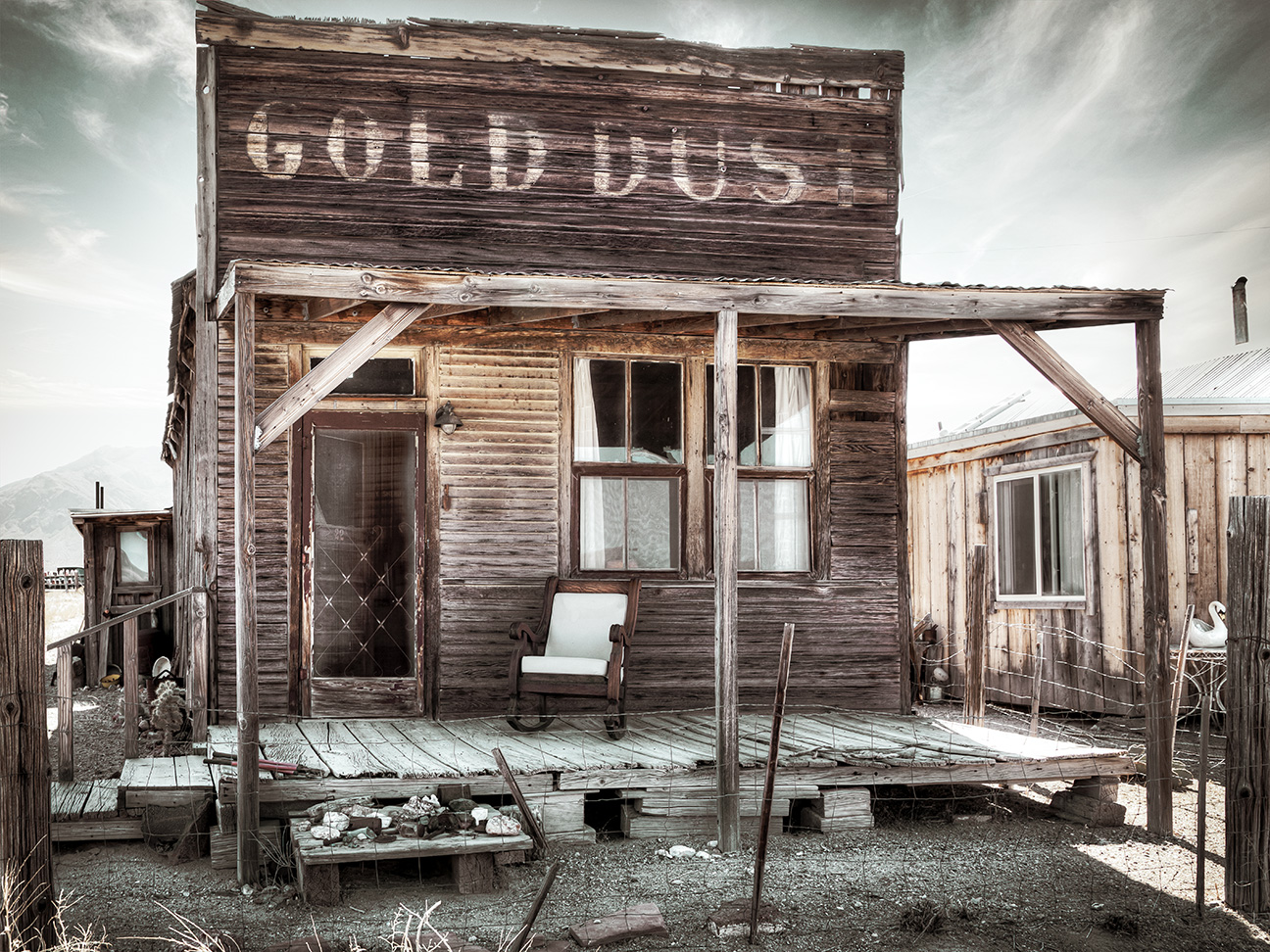
Gold Dust, Gold Point Ghost Town, Esmeralda County Nevada September 2020. Photo credit: James Marvin Phelps via Flickr
That resistance was crushed. Many noncombatants were killed and others forcibly displaced to Washington; the destruction continued for decades and hasn’t stopped yet.
Today the land base of the Paiute, Shoshone, and Bannock peoples of the area — collectively known as Atsawkoodakuh wyh Nuwu or Red Mountain Dwellers — is permeated by both abandoned and active mines. Gold and tungsten mining waned in the early to mid-1900s, but then companies started extracting uranium and mercury at the McDermitt and Cordero mines across the road from Fort McDermitt. According to Department of the Interior archives, this was the nation’s largest mercury mine from the 1930s to the 1970s. After the Cordero mine closed, crews spread arsenic-contaminated waste from the mine around the town and reservation as a fill dirt. The region was later declared a Superfund site, and the contaminants were removed between 2009 and 2013.
But the toxic waste caused decades of harm in the community before that removal. In a brazen environmental injustice, many Tribal members who worked there perished of cancer. Sunoco and Barrick Gold, the companies that exploited the quicksilver lode, simply “declined” the EPA’s order to clean up the area and escaped culpability.
Now the sacred landscape of Peehee Mu’huh will become the country’s largest lithium bounty.
In an attempt to distance themselves from past mining injustices, spokespeople for Lithium Nevada Corporation present a new story, saying they use mitigation and undertake community engagement. In a June 2023 appeal hearing, they even claimed that, after mitigation, only five acres of the 17,933-acre project area would have “permanent disturbance for wildlife and habitat.” Indeed, they would leave a “net conservation gain” using the state’s conservation credit scheme.
But far from bringing a “gain,” this will devastate local ecology. Scientists have documented that greater sage grouse (Centrocercus urophiasanus) live in the area and return to their mating grounds, or leks, in the same spot. Once that land is gone, the birds are gone. Plans to reseed native plants or number-crunch to make habitat materialize on paper cannot change that fact. As scholars have shown, theoretical (i.e. empty) habitat is not the same thing as a population, but the system for healing post-mine lands mandates such scams to justify ecosystem destruction.
Due to livestock production, sprawling car-centered urbanization, and other factors, the sagebrush steppe biome is one of the most threatened ecosystems in the western United States. Near-threatened species like greater sage grouse and Lahontan cutthroat trout (Oncorhynchus clarkii henshawi) face encroachments and irreversible change.
Meanwhile the McDermitt Caldera, the extinct volcanic hotspot where Peehee Mu’huh rests, now contains four more proposed lithium and uranium mines. Whether these resources will enact a profound cut in fossil fuel pollution remains to be seen.
What is easy to envision, however, is mining that continues wiping out carbon-sequestering sagebrush, the further suppression of mass transit by the fossil-fuel lobbies, and the dominance of cars. Last year General Motors invested $650 million in Thacker Pass, surpassed by the Department of Energy’s $2.26 billion loan to the mine company in March. The People of Red Mountain face new barriers and constrictions on their own homeland at the expense of EV-mobility for well off consumers afar.
Moving Forward
The social movement has shifted toward broadly protecting McDrmitt Caldera as a cultural landscape and critical habitat, as well as supporting the creation of a nearby Owyhee Canyonlands National Monument to pause new extraction in the northern stretch of Paiute-Shoshone lands.
Yet the proposed national monument — like other Forest Service, designated wilderness areas, and even national park lands — does not ban extraction outright. The proposed monument boundary also excludes McDermitt Caldera, where sage grouse dance on their mating grounds and Lahontan cutthroat trout swim through the canyon streams.
Conservation easements are one option that may bring more land into Tribal resource management and protection. Another key method to protect sacred landscapes is for all entities to respect Tribes’ consent — and fundamental right — to accept or decline development projects on their lands, per the United Nations Declaration on the Rights of Indigenous Peoples.
Perhaps what’s needed at a broader scale is awareness that Indigenous peoples are guardians of biodiversity. Mining and car companies are unlikely to lead the way to equitable, low-emissions futures since they focus on profit. We must reconnect the struggle for climate justice in our atmosphere to the quest for Indigenous land rights on the ground.
Left unchecked, colonial extraction patterns will undermine a “just transition,” leading instead to an unjust continuation of familiar forms of environmental oppression.
Map of Nevada’s major rivers and streams via Geology.com.


