#Wyoming shoots itself in the foot: Veering away from the more pragmatic conservatism of Teddy Roosevelt or even Ronald Reagan, and into the hard right, anti-government quagmire — Jonathan P. Thompson (WritersOnTheRange.org)

Click the link to read the article on the Writers on the Range website (Jonathan P. Thompson):

October 14, 2024

This summer, the Biden administration offered Wyoming $35 million to help the state plug and clean up abandoned oil and gas wells. When Wyoming turned down the cash, it seemed hard to believe.

It could cost the state more than twice that amount to reclaim its 1,000 or so defunct wells that remain unplugged. Economists have also warned that market forces will continue to diminish the stateโ€™s main revenue sourceโ€”severance taxes on fossil fuels.

Thatโ€™s not all. Last year, Wyoming turned down federal money for electric vehicle charging stations. Then, when Governor Mark Gordon refused to take part in the EPAโ€™s pollution reduction program, the state lost tens of millions of dollars in federal funding.

Meanwhile, the state is spending millions of taxpayersโ€™ dollars on lawsuits seeking to eviscerate Biden administration rules aimed at protecting the environment and human health and mitigating harmful effects of climate change.

Itโ€™s all part of a disturbing shift among Western Republicans and the states they dominate. They are veering away from the more pragmatic conservatism of Teddy Roosevelt or even Ronald Reagan, and into the hard right, anti-government quagmire.

Governor Gordon has been swept up in this shift. Gordon was born in New York City and grew up on the family ranch in Kaycee, Wyoming. He registered as a Republican at age 18, attended Vermontโ€™s Middlebury College, then came back to Wyoming to continue ranching. At the same time, he pushed back on the coalbed-methane drilling boom that was ravaging his state, a fact missing from his official biographies.

Gordonโ€™s activism included serving on environmental groupsโ€™ boards and he went on record attacking the energy industry for turning Buffalo into โ€œthe place that stinks on the way to Casper.โ€ Nevertheless, he later worked for an oil company as its conservation director.

He still straddled the fence politically, donating to both Republican and Democratic candidates and committees on a state and national level during the 1990s and early 2000s. But he was not an anomaly; this sort of ideological flexibility was once common in Western states.

When Gordon ran for Congress as a moderate in 2008, he said both the Republican Party and the Sierra Club had โ€œgotten off track,โ€ with the GOP moving too far to the right and abandoning Roosevelt-style conservationism. He said environmentalists also became less willing to compromise, particularly on public-land grazing issues.

Gordon ended up losing the primary to hardliner Cynthia Lummisโ€”now a U.S. senatorโ€”after she attacked Gordon for his environmental ties and bipartisan tendencies. But Gordon stuck to his relatively moderate stance when he ran for governor in 2018 and defeated hardliner Harriet Hagemanโ€”who would later unseat Liz Cheney.

As governor, Gordon has acknowledged human-caused climate change and supported clean-energy development, while also looking to keep the fossil fuel industry afloat by pushing carbon capture rather than closing coal plants or regulating drilling.

He was forceful and eloquent in condemning the January 6, 2021 attack on the Capitol, tweeting: โ€œInterfering with the peaceful transfer of power is an affront to the very Constitution that has made our country what it is. I believe America will notโ€”cannotโ€”stand for this assault on our democracy.โ€

This centrism has played well with voters. Gordon easily won a second term in 2022. But the radical right-wing, climate-denying branch of Wyomingโ€™s legislature, the Freedom Caucus, has relentlessly blasted him for it.

In purple states, such as Arizona, the radicalization of the GOP has been met with backlash from moderates, who can seek refuge in a growing Democratic Party. But in Wyoming, newcomers fleeing more liberal states are turning the legislature a deeper shade of red, lending power and members to the Freedom Caucus.

The Wyoming governor has struggled to hold his ground. His rhetoric on Bidenโ€™s purported โ€œwar on fossil fuelsโ€โ€”and the stateโ€™s legal challenges to common-sense environmental protectionsโ€”have grown more strident, even though Gordon knows full well that market forces, not regulations, are behind the industriesโ€™ decline.

The intent here is not to heap criticism on Gordon; he gets enough of that from his party members. Rather it is to lament the imminent extinction of the moderate, conservation-leaning, pragmatic Western Republican.

Jonathan Thompson

Think of all those missed opportunities. In todayโ€™s political climate, Gordon either must adapt or be thrown out of office, and thatโ€™s not good for Wyoming or the West.

Jonathon Thompson is a contributor to writersontherange.org, an independent nonprofit dedicated to spurring lively conversation about the West. He is the editor of The Land Desk and a longtime Western author and writer.

ย Jonathan Thompson

The system that moves water around the Earth is off balance for the first time in human history — CNN

Diagram credit: USGS

Click the link to read the article on the CNN website (Laura Paddison). Here’s an excerpt:

October 16, 2024

Humanity has thrown the global water cycle off balance โ€œfor the first time in human history,โ€ fueling aย growing water disasterย that will wreak havoc on economies, food production and lives, according to a landmark new report. Decades of destructive land use and water mismanagement have collided with theย human-caused climate crisisย to put โ€œunprecedented stressโ€ on the global water cycle,ย said the report published Wednesday by the Global Commission on the Economics of Water, a group of international leaders and experts.

Credit: Stefan Rahmstorf

Disruptions to the water cycle are already causingย suffering. Nearly 3 billion people faceย water scarcity.ย Crops are shrivelingย andย cities are sinkingย as the groundwater beneath them dries out. The consequences will be even more catastrophic without urgent action. The water crisis threatens more than 50% of global food production and risks shaving an average of 8% off countriesโ€™ GDPs by 2050, with much higher losses of up to 15% projected in low-income countries, the report found.

โ€œFor the first time in human history, we are pushing the global water cycle out of balance,โ€ said Johan Rockstrรถm, co-chair of the Global Commission on the Economics of Water and a report author. โ€œPrecipitation, the source of all freshwater, can no longer be relied upon.โ€

Graphic showing the movement of “green water” and “blue water” in the global water cycle. Global Commission on the Economics of Water

The report differentiates between โ€œblue water,โ€ the liquid water in lakes, rivers and aquifers, and โ€œgreen water,โ€ the moisture stored in soils and plants. While the supply of green water has long been overlooked, it is just as important to the water cycle, the report says, as it returns to the atmosphere when plants release water vapor, generating about half of all rainfall over land. Disruptions to the water cycle are โ€œdeeply intertwinedโ€ with climate change, the report found. A stable supply of green water is vital for supporting vegetation that can store planet-heating carbon. But the damage humans inflict, including destroying wetlands and tearing down forests, is depleting these carbon sinks and accelerating global warming. In turn, climate change-fueled heat is drying out landscapes, reducing moisture and increasing fire risk.

Windy Gap Reservoir nearly crashed an aquatic ecosystem. A $33 million water project is undoing the damage — Fresh Water News #ColoradoRiver #COriver #SouthPlatteRiver

The $33 million Colorado River Connectivity Channel diverts the river around the Windy Gap Dam to improve river health, fish passage and habitat in the upper headwaters of the Colorado River. (Northern Water, Contributed)

Click the link to read the article on the Water Education Colorado Website (Shannon Mullane):

October 17, 2024

With the snip of a ribbon Tuesday, Colorado water managers officially opened a new waterway in Grand County that reconnects a stretch of the Colorado River for the first time in four decades to help fish and aquatic life.

The milelong waterway, called the Colorado River Connectivity Channel, skirts around Windy Gap Reservoir, where a dam has broken the natural flow of the river since 1985. The $33 million projectโ€™s goal is to return a stretch of the river to its former health, a river where aquatic life thrived and fish could migrate and spawn. But getting to the dedication ceremony Tuesday took years of negotiations that turned enemies into collaborators and can serve as a model for future water projects, officials say.

โ€œIt speaks to the new reality of working on water projects, which is that it doesnโ€™t have to be an us-versus-them situation,โ€ Northern Water spokesperson Jeff Stahla said. โ€œPeople can get together and identify things that can help not only the water supply, but also help the environment.โ€

Windy Gap Reservoir and the new channel are just off U.S. 40 near Granby, a few miles southwest of popular recreation areas around Lake Granby and Grand Lake.

The reservoir was designed to deliver an average of 48,000 acre-feet of water per year from Grand County through numerous reservoirs, ditches, canals and pipelines to faucets in homes and sprinklers on farms across northeastern Colorado. One acre-foot roughly equals the annual water use of two to three households.

But soon after construction finished in 1985, locals and fly fishermen started noticing problems โ€” starting with the bugs.

Drivers used to cleaning insects out of their radiators suddenly had one less chore as certain types of mayflies, stoneflies and caddisflies disappeared. In 2011, state biologists calculated a 38% loss in diversity between the early 1980s and 2011.

The dam blocked fish passage, and the reservoir became a breeding ground for whirling disease, a deadly condition for local trout caused by a microscopic parasite.

Windy Gap Reservoir before construction started for the Colorado River Connectivity Channel. The dam, built in 1985, blocked the Colorado River and inhibited a healthy fishery. The new channel around the reservoir will improve the health of the Upper Colorado River. (Northern Water, Contributed)

It choked seasonal high flows. Without the flows to flush the sediment from between small rocks, the habitat for a fundamental food source, small organisms called macroinvertebrates, diminished. The sculpin, a small fish that often serves as an indicator of river health, disappeared entirely.

Macro Invertebrates via Little Pend Oreille Wildlife Refuge Water Quality Research

โ€œThe ecosystem started crashing,โ€ said Kirk Klancke, a longtime conservationist in the area. โ€œIt didnโ€™t die out completely, but it certainly started crashing. We lost all the sensitive, most important macroinvertebrates.โ€

The fisheryโ€™s gold medal status was threatened, and losing that would have been a blow to the local economy, he said.

The reservoir also couldnโ€™t reliably serve its main purpose: catching water and pumping it 6 miles to Lake Granby to eventually reach the Front Range. When the lake is filled to the brim in wet years, it canโ€™t store Windy Gapโ€™s water, leaving northeastern communities in the lurch, according to Northern Water.

Restoring a river channel in the Upper Colorado Basin. Graphic credit: Northern Water

The new channel is the fix.

To create the channel, the Northern Colorado Water Conservancy District started work in 2022, draining Windy Gap Reservoir and cutting its size in half. The result is a smaller reservoir and a floodplain through which the channel flows.

Crews built a new diversion headgate โ€” the main focus of the dedication this week โ€” that manages how much water enters the reservoir from the channel. They removed a small, upstream dam crossing the Fraser River that blocked fish passage.

After vegetation is established, the channel will open to fishing and recreation, likely around 2027.

Water has been flowing through the channel for about a year, and officials are already seeing benefits: Colorado Parks and Wildlife said Tuesday that the sculpin has been detected in that stretch for the first time in 20 years.

โ€œSeeing the project come to fruition, and then getting the bonus of having wildlife biologists tell you, โ€˜Yep, weโ€™re already seeing signs of biological healing,โ€™ was just mind blowing,โ€ said Tony Kay, former president of Trout Unlimited who has been working on connecting the river for 26 years.

It was emotional. Not everyone who started this process was able to see it through to the end, like Bud Isaacs, a downstream landowner who was one of the first to raise the alarm and who passed away in 2022, Kay said.

โ€œWe never actually thought that this would happen,โ€ he said.

The channel is also one facet of a sweeping, multimillion-dollar plan to fix multiple problems in one go.

Through the Windy Gap Firming Project, growing Front Range communities will have more reliable water storage in the form of Chimney Hollow Reservoir, which is under construction near Loveland and will work in tandem with Windy Gap to provide water supplies.

The effort to build the connectivity channel has seemed slow moving at times, but officials, environmentalists and urban areas are celebrating it as an example of hard-won collaboration.

โ€œIt was a gamble to partner with Front Range water diverters. There were a lot of people who told us you canโ€™t do deals with the devil. Youโ€™re going to end up really regretting it,โ€ Klancke said. โ€œThe connectivity channel has proved we went down the right road.โ€

Itโ€™s also just one step in addressing chronic low-flow issues along the upper Colorado River caused by drought and massive water diversions to Coloradoโ€™s Front Range, Klancke said.

In five years time, Kay hopes to see a healed river through the new channel and farther downstream. Heโ€™ll be saying โ€œthank youโ€ every time he drives past that stretch of the river.

โ€œBud would be over the moon,โ€ he said.

More by Shannon Mullane

Colorado transmountain diversions via the State Engineer’s office

Topsoil Moisture % short/very short (s/vs) October 13, 2024: 62% of the Lower 48 is s/vs, 10% more than last week. — @NOAADrought

Soils in much of the West & Central U.S. dried out; many states in the MS & OH River basins saw 10-20% increases in s/vs soil moisture.

The latest seasonal outlooks through January 31, 2025 are hot off the presses from the #Climate Prediction Center

U.S. Army Corps of Engineers’ approval of Gross Reservoir dam expansion violated environmental law, judge rules — The #Denver Post

The dam raise process begins at the bottom of the dam using roller-compacted concrete to build the new steps that will go up the face of the dam. Photo credit: Denver Water.

Click the link to read the article on The Denver Post website (Elise Schmelzer). Here’s an excerpt:

October 17, 2024

The U.S. Army Corps of Engineers violated the Clean Water Act and the National Environmental Policy Act when approving permits for the construction of the dam, U.S. District Court Judge Christine Arguello found in the ruling, issued Wednesday. The federal agency failed to sufficiently consider other options that could be less environmentally damaging than dam expansion,ย Arguello wrote in her order. Arguello did not order Denver Water to stop construction on the dam, in part because the utility already plans to halt construction in November for the winter season. An abrupt halt to the project could also affect the integrity of the dam, she wrote. The defendants and plaintiffs will now work to create a remedy for the improperly issued permits. Each side must submit briefs on proposed solutions to Arguello by Nov. 15. In a statement, Denver Water said it still hopes โ€œto move the project toward completion.โ€

[…]

Denver Water argued in its filings that the issues raised were moot since construction had already begun and one of the permits in question already used. Arguello, however, dismissed that argument, as the reservoir had not yet been expanded and the 400 acres of land and 500,000 trees it would drown still remained above water…

One of the Army Corps of Engineersโ€™ failures was its lack of analysis of how climate change could impact the project. As climate change shrinks the amount of water available in the Colorado River system, Arguello asked, is it practical and reasonable to build a reservoir to store water that doesnโ€™t exist? The lack of analysis shows that the USACE did not fully analyze the practicality of the dam project, as required by law, she wrote.

#Colorado Leading on #Geothermal: Governor Polis Congratulates Colorado Mesa University on Being a Featured Department of Energy Top Case Study

The benefits of this geo-exchange system extend beyond environmental impact. By significantly reducing energy costsโ€”saving millions of dollars each yearโ€”CMU is able to keep tuition affordable. These savings directly support the CMU Promise, additional merit aid, more scholarships, and other cost-saving initiatives that benefit students. Photo credit: Colorado Mesa University (June 7, 2024)

Click the link to read the release on Governor Polis’ website (Eric Maruyama):

October 11, 2024

Today, Governor Polis celebrated Colorado Mesa Universityโ€™s (CMU) nation-leading geothermal heating system for being recognized as one of only 19 case studies across the nation by the Department of Energy as one of the best geothermal systems. 

โ€œCongratulations to Colorado Mesa University for being featured as a U.S. Department of Energy case study for geothermal heating. CMU has one of North America’s largest geothermal heat pump systems and connects 16 buildings, providing 90% of the energy required to operate the campus. Plans are underway to connect the remaining campus buildings, comprising 800,000 square feet, to the central loop to achieve a 100% geothermal campus. CMUโ€™s work is a great example of Coloradoโ€™s leadership in providing clean, low-cost energy resources,โ€ said Governor Polis. 

CMUโ€™s gold-standard geothermal system regulates 1.2 million square feet of building space, has saved the university $15.9 million in heating and cooling costs since 2008, and reduces CMUโ€™s carbon footprint by nearly 18,000 metric tons of CO2 each year. As chair of the Western Governorโ€™s Association, Governor Polisโ€™s Heat Beneath Our Feet Initiative focused on advancing innovative geothermal solutions. Earlier this year, Governor Polis announced $7.7 million in awards for 35 Geothermal projects across the state. Governor Polis and the Colorado Energy Office also recently launched Tax incentives to increase Geothermal electricity production. 

#Drought news October 17, 2024: Moderate and severe drought expanded over eastern #Colorado and abnormally dry conditions expanded over portions of northeast #Colorado and into #Wyoming and #Nebraska, most all of the West was dry this week

Click on a thumbnail graphic to view a gallery of drought data from the US Drought Monitor website.

Click the link to go to the US Drought Monitor website. Here’s an excerpt:

This Week’s Drought Summary

Precipitation across the country was pretty much nonexistent over the past week. The outliers were in Florida as Hurricane Milton came ashore and brought with it copious amounts of rain over much of the peninsula, as well as some rains in the upper Midwest into New England, and some coastal areas of the Pacific Northwest. From the Mississippi River west, most areas were warmer than normal, with departures of 9-12 degrees or more above normal over much of the southern Plains, Rocky Mountains, and into the desert Southwest. Cooler-than-normal temperatures were recorded along the Eastern Seaboard with departures of 3-6 degrees below normal quite common…

High Plains

The dry pattern continued over the High Plains with only a small area of North Dakota recording any precipitation this week. The warm temperatures continued as well with most areas 4-8 degrees above normal and even greater departures of 8-12 degrees above normal in the plains of Wyoming and Colorado and portions of western Nebraska and South Dakota. Degradation took place from North Dakota to Kansas and into the plains of Montana, Wyoming, and Colorado. Moderate and severe drought were expanded in North Dakota, mainly in the south and west portions of the state. South Dakota had moderate and severe drought expand in the northern, southern, and western portions of the state and had extreme drought expand in the northwest and a new area in southern portions of the state. Nebraska and Kansas both had severe and moderate drought expand over many areas of the state. Kansas had extreme drought expand in the far southeast. Moderate and severe drought expanded over eastern Colorado and abnormally dry conditions expanded over portions of northeast Colorado and into Wyoming and Nebraska. Eastern Wyoming had moderate, severe, and extreme drought conditions expand…

Drought Monitor one week change map ending October 15, 2024.

West

As with the Plains and the South, most all of the West was dry this week with only some coastal areas of California and Washington measuring any precipitation. Warm temperatures dominated the region with almost everyone at least 3-6 degrees above normal for the week and areas of Utah, Idaho, Colorado, Nevada, Wyoming and southern Montana 9-12 degrees above normal. Abnormally dry and moderate drought conditions expanded over Washington and Oregon. In Arizona, moderate and severe drought expanded in the southern portions of the state and into southern California. Moderate drought also expanded in central Arizona. The heat that has impacted the Southwest has been record-setting. Phoenix went 21 straight days of setting all-time daily high temperature records that ended on October 15, when the high temperature of 99 degrees Fahrenheit did not break the daily high. New Mexico had severe and extreme drought expand over southern parts of the state, while abnormally dry conditions filled in more of the west. Moderate drought emerged in southwest Colorado, with severe drought expanding and a new area of extreme drought in the north central portions of the state. Utah had abnormally dry conditions and moderate drought expand in the east. In Wyoming, moderate drought expanded over the southwest part of the state, severe drought expanded in the central area, and moderate drought expanded in the northwest…

South

Warm temperatures dominated the region with some areas of Texas having temperatures greater than 10 degrees above normal. The entire region was warmer than normal outside of far south Texas and portions of southern Louisiana. Like the High Plains, precipitation was pretty much nonexistent in the region this week, and coupled with the warm temperatures, degradation took place over much of the region. In Oklahoma, moderate and severe drought expanded in the central portions of the state while extreme drought expanded in the northeast. Northwest Arkansas had moderate, severe, and extreme drought all expand, while in Louisiana, moderate drought expanded in the north and in the south, with a new pocket of severe drought introduced in the south. A new area of moderate drought emerged in southern Mississippi and into southern portions of Louisiana. Moderate drought expanded over portions of central Tennessee. Texas had widespread degradation over much of the east and central portions of the state as well as expansion of moderate drought over the Panhandle. Severe and extreme drought expanded in the central portion of the state, where long-term indicators are showing drought at various timescales. Along the border with Oklahoma, severe and extreme drought expanded slightly…

Looking Ahead

Over the next 5-7 days, it is anticipated that much of the Rocky Mountain and central Plains areas will have the best chances for measurable precipitation. The highest amounts are anticipated over northeast New Mexico, southeast Colorado, and parts of the Oklahoma and Texas panhandles, where 2 or more inches may be recorded. Most of the other areas are expecting an inch or less. Temperatures during this time are anticipated to be above normal over much of the Plains, Midwest, and into the Northeast, with departures of 10-15 degrees above normal over the upper Midwest. Cooler than normal temperatures of 2-4 degrees below normal are expected over the Four Corners region and the Rocky Mountains.

The 6-10 day outlooks show that above-normal temperatures will continue for almost all of the country through the end of October, especially from Texas into the Midwest. The coastal areas of the Pacific Northwest have the greatest probabilities of below-normal temperatures during this time. Outlooks show that the greatest chances of below-normal precipitation are from the Gulf Coast into the Midwest and over much of the East. The highest probabilities of above-normal precipitation will be in the central to northern Plains, northern Rocky Mountains and into portions of the Pacific Northwest.

US Drought Monitor one week change map ending October 15, 2024.

#Colorado Supreme Court โ€œslow sipโ€ ruling could affect city water supplies from fast-growing #Greeley to #CastleRock — Fresh Water News

Water stored in Coloradoโ€™s Denver Basin aquifers, which extend from Greeley to Colorado Springs, and from Golden to the Eastern Plains near Limon, does not naturally recharge from rain and snow and is therefore carefully regulated. Courtesy U.S. Geological Survey.

Click the link to read the article on the Water Education Colorado website (Jerd Smith):

October 10, 2024

Nearly 40 years ago, after watching aquifers below Douglas County plunge amid fast growth and heavy use, Colorado lawmakers adopted a โ€œsip slowlyโ€ management process that required communities such as Parker and Castle Rock to pump out fixed amounts of nonrenewable groundwater each year in an effort to make the resource last at least 100 years.

Fast forward to 2020. That year, the state directed well owners to sip even slower, explicitly stating how much water their permits entitled them to, and requiring them to stop pumping at the end of that 100-year period if they have fully used the water to which they were entitled when the original well permits were issued.

But Parker and Castle Rock objected, suing the state over the new permitting language. They argued that the original volume estimates used to calculate their annual pumping rates were never meant as formal, total volume limits. Those limits, they argued, could sharply limit their future water supplies because they were essentially a best guess, based on measuring technology that has changed considerably since then.

Aurora and Greeley joined the case, siding with the state. A special water court ruled against Parker and Castle Rock, which together appealed to the Colorado Supreme Court. The high court is expected to issue a ruling in the case before the end of the year, according to spokeswoman Suzanne Karrer.

Under Coloradoโ€™s so-called 100-year rule, well owners can extract no more than 1% of the water under their lands each year, pumping all the water within 100 years of the issuance of their permits. But prior to use of the new permitting language, the total volume of water that could be taken out over the life of the permit was never explicitly stated on the permits themselves, though it was used to calculate the annual extraction rate.

State officials said they added the water volumes to ensure wells are regulated in a uniform way and that well owners are informed at the start of that 100-year clock how much actual water they can pump.

Deputy State Engineer Tracy Kosloff explained, via email. โ€œIf the amount pumped is less than the annual maximum, the length of time it takes to reach the total allowed withdrawal will be more than 100 years. For instance, if one pumps half of the maximum each year, it will take 200 years to reach the total.โ€

However, if the maximum allowed each year is pumped, then the permit will expire at the end of the 100 years, and the well owner would have to stop pumping and find other water sources, Kosloff said.

But Parker and Castle Rock argue that water levels in the aquifer vary and that over that 100-year period more water might actually be available to them. Establishing a lifetime limit, especially one based on an estimate and old measuring technology, could deprive them of water to which they are entitled.

Colorado designated groundwater basins.

Colorado is home to several aquifer formations, some of which can be easily recharged via rainfall and snowmelt, and are considered renewable. Others cannot be readily recharged and thus are considered to be nonrenewable. These are known as nontributary aquifers and wells drilled in these areas are at the heart of the dispute.

Sean Chambers, Greeleyโ€™s director of water and sewer utilities, supports water regulatorsโ€™ effort to more closely manage nonrenewable underground supplies by including a specific volume on permits because it will better protect everyone over the long run.

Greeley is planning a major new aquifer storage facility on the Wyoming border known as the Terry Ranch. The city wants to ensure water it stores underground isnโ€™t inadvertently tapped by other users whose pumping could siphon off the cityโ€™s supplies, Chambers said via email.

When it became clear in the 1980s and 1990s that the aquifers were in decline, Douglas County communities began reducing the amount of water they were taking out of the aquifers, adding surface supplies from the South Platte River and Cherry Creek, and building multimillion dollar water recycling plants so they can reuse the water they already own.

Parker once relied on nonrenewable groundwater for more than 90% of its supplies, but has since reduced that use to roughly 35%. By 2050, it hopes to drop that amount to 25% of its supplies, according to Ron Redd, manager of the Parker Water and Sanitation District.

Ultimately, Redd said, itโ€™s likely that the state laws on the books now will have to be changed as a result of the dispute.

โ€œIf we lose, we will try to run legislation upholding our interpretation of the law,โ€ he said. โ€œWe were surprised by this. No one knew it was coming until suddenly we saw this condition on our well permits.โ€

More by Jerd Smith. Jerd Smith is editor of Fresh Water News. She can be reached at 720-398-6474, via email at jerd@wateredco.org or @jerd_smith.

Water treatment process in Greeley. Graphic via Greeley Water

#Californiaโ€™s new water recycling rules turn #wastewater to tapwater — LAInst.com

Rupam Soni, MWDโ€™s community-relations team manager, gives a tour of MWDโ€™s Pure Water Southern California demonstration facility. MWD is hoping to soon use recycled wastewater, known as direct potable reuse, to augment its supplies from the Colorado River. CREDIT: HEATHER SACKETT/ASPEN JOURNALISM

Click the link to read the article on the LAInst.com website (Erin Stone). Here’s an excerpt:

October 7, 2024

This month,ย statewide regulationsย for whatโ€™s technically called โ€œdirect potable reuseโ€ went into effect. The rules allow wastewater โ€” yes, the water that goes down the drain or is flushed down the toilet โ€” to be treated to drinkable standards then distributed directly to homes and businesses. Mickey Chaudhuri, treatment and water quality manager for the Metropolitan Water District of Southern California (MWD), said the new rules are โ€œa gamechanger.โ€

Previously, California law only allowed โ€œindirectย potable reuse,โ€ which is what the Fountain Valley facility does โ€” highly treated wastewater is injected underground into an aquifer, where further, natural filtration occurs. Then that water is put into the pipelines to our homes and businesses. Directย potable reuse, which is what these newly effective regulations are about, skips that step where the water is injected into groundwater basins. Instead, the highly treated sewage water goes directly to drinking water treatment plants and then is distributed…ecause these new regulations allow recycled water to be put directly into the local water system, more cities can recycle water for drinking that donโ€™t happen to have an underground basin, or donโ€™t have enough space in groundwater basins because of past pollution, which isย the case for cities such as L.A.ย and Santa Monica.

Wildfires donโ€™t just burn farmland โˆ’ they can contaminate the water farmers use to irrigate crops and supportย livestock

A water pipe that was used to carry water to livestock crosses land burned in the Maui fires in August 2023. Andrew Whelton/Purdue University, CC BY-ND

Andrew J. Whelton, Purdue University

The wildfires that burned across Maui, Hawaii, in August 2023 became the deadliest conflagration in the United States in more than a century. While the harm to homes and tourism drew the most attention, agriculture was also heavily affected across the island, and the harm did not stop once the flames were out.

In some cases, fires smoldered underground for weeks. Water systems were destroyed, and some were contaminated in ways scientists are only beginning to understand.

smoke comes from a burned area underground.
Two weeks after the Maui fires began, they were still smoldering below ground. Andrew Whelton/Purdue University, CC BY-ND

As an environmental engineer, I work with communities affected by wildfires and other disasters. I also led a team of university and public works professionals to assist in Mauiโ€™s response to the fires.

In a new study based on that effort, my team worked with the Hawaii Department of Agriculture to assess damaged water systems, including water pipes, wells and pumps that are essential for livestock and crops. It was the first study of its kind to examine wildfire damage to agriculture water systems.

The results show the types of damage that can occur when a fire burns through property, and they offer a warning to agricultural regions elsewhere. With the U.S. averaging over 60,000 wildfires and 7.2 million acres burned each year, it is clear that wildfires have become a whole-of-society problem.

Contaminated water infrastructure poses risks

Wildfires often knock out power, which can disable water pumps that farmers and ranchers rely on. They can also damage pipes in ways that can release toxic chemicals and have long-lasting effects.

Recent municipal water system studies by my team and others have shown that water sources and even the pipes and tanks can become unsafe to use. Studies in fire-swept areas have found levels of volatile organic compounds, or VOCs, such as benzene, a carcinogen, above hazardous waste limits. Exposure to this water can cause immediate harm to people.

When water pumps stop working or components are destroyed, municipal water systems lose pressure. When that happens, VOCs can enter from heated or burning plastics, structures and vegetation.

Two water tanks in a field.
Even when tanks are untouched by fire, the pipes serving them can be contaminated if they heat up. Andrew Whelton/Purdue University, CC BY-ND

An insidious challenge is that VOCs penetrate plastic water lines, gaskets and tanks like water going into a sponge. Even after bad water is flushed out, chemicals can leach from the plastic and make the water unsafe for weeks to months. Damaged components have to be replaced.

In the wake of the Maui fires, however, there was no immediate guidance on how farmers and ranchers should inspect and test their water systems.

Learning from Mauiโ€™s experience

Farms and ranches had many plastic water system components. On one ranch, fire destroyed more than nine miles of plastic water pipe. Much of the pipe ran above ground alongside fencing, which also burned.

Plastic irrigation systems were destroyed. Numerous other components melted, were leaking or lacked water. The loss of power sometimes prevented water pumps from keeping the pipes full of water.

A melted pipe with a hole in it lays on the ground.
Some plastic water lines burst due to the temperature and water pressure during the fire. Andrew Whelton/Purdue University, CC BY-ND
A melted pipe in a wooded area.
More than 9 miles of plastic polyethylene water lines were destroyed by the fire. Andrew Whelton/Purdue University, CC BY-ND

While wells can become contaminated and well casings can burn, the wells themselves were not contaminated. This was mostly because the wells were set back from combustible materials and because firefighters and property staff helped to protect them.

Debris and particles from smoke, however, did enter animal troughs, buckets and waterers. These items had to be drained and cleaned for the safety of the animals. Water systems were repeatedly flushed with clean water after the fire, and VOC testing of the water supplies did not find lingering contamination.

Lots of questions still to answer

There are still many unanswered questions. Since there was no VOC testing procedure for agricultural water systems before the fires, there is no data to show the frequency and severity of this kind of contamination.

Not all municipal water systems that suffer fires become contaminated. Contamination is related to differences in the sites, systems and the fires themselves.

A plastic bowl attached to a fence with a water line coming into it.
Animal watering systems are often supplied by plastic pipes. Andrew Whelton/Purdue University, CC BY-ND

There is also no data on the degree to which this wildfire-contaminated water would harm animals and crops. Would animals avoid the water and become dehydrated? Can crops become contaminated? Will exposure affect the meat of livestock? Many of these unanswered questions will require the expertise of veterinary medicine and crop and soil scientists.

What are the solutions?

One thing that was clear is that farmers and ranchers lack adequate guidance to prevent wildfire-caused pollution of their water systems. Some practical lessons learned can help these community members bounce back:

  • Defensible space should be established by keeping equipment 30 feet away from combustible materials. Burying plastic components 3 feet underground helps protect them from fire.
  • Similar to municipal water systems after a fire, damaged agriculture water system components should be isolated. Pipes and tanks should be rapidly refilled and extensively flushed with water to help remove potential contamination.
  • Water delivery devices, including troughs, buckets and tire waterers, should be drained and cleaned. When contamination is a concern, chemical water testing should be conducted. In some cases, components will have to be replaced.
A cow in a field with burn landscape behind it.
Pipes and wells to get water to cattle can also be at risk in wildfires. Andrew Whelton/Purdue University, CC BY-ND

A 2024 survey of California farmers shows that the top three resources โ€œrelied on and wished for during wildfireโ€ were generators, water pumps and water storage tanks. These items would help prevent water system pressure loss and contamination.

Who can help?

Wildfire risk to farms and ranches can be reduced. State and federal agriculture departments and insurance companies can provide financial assistance. Technical assistance is available from universities.

Lessening the impact of wildfires and expediting recovery can help farms and ranches do yeomanโ€™s work to support health and the economy.

Andrew J. Whelton, Professor of Civil, Environmental and Ecological Engineering, Purdue University

This article is republished from The Conversation under a Creative Commons license. Read the original article.

A receding #LakePowell is bringing #ColoradoRiver rapids in #Utah back to life — National Public Radio #COriver #aridification

Raft in the Big Drop Rapids, Cataract Canyon. By National Park Service – National Park Service, Public Domain, https://commons.wikimedia.org/w/index.php?curid=8327636

Click the link to read the article on the National Public Radio website (Ari Shapiro/Luke Runyon). Here’s an excerpt:

October 15, 2024

Thereโ€™s a lot of anxiety about climate change shrinking Lake Powell, but it also means whitewater rapids upstream have re-emerged. Thrillseekers can now run them for the first time since the 1960s.

ARI SHAPIRO, HOST: 

At the bottom of a deep, red rock canyon in the desert southwest, the Colorado River is restoring itself, or at least a part of itself, even as climate change shrinks its volume. And that has river enthusiasts celebrating. Long-forgotten whitewater rapids are reemerging upstream. Reporter Luke Runyon set out to find more.

LUKE RUNYON, BYLINE: Ah. We just docked our boats to scout Gypsum Canyon Rapid. The sky is blue. The sun is out. It’s hot, and you can hear the water roaring.

PETE LEFEBVRE: I’m just going to go down this main wave train and look for this doamer (ph) rock and tuck underneath that.

RUNYON: Professional river guide Pete Lefebvre has been down Cataract Canyon more than 130 times, but he’s never seen Gypsum Rapid. And it looks mean, a churning, roiling mess of water and boulders.

PETE LEFEBVRE: It’s steep. It’s sharp. It’s a must-make move. And I’m nervous (laughter).

RUNYON: Lefebvre has never seen this rapid because for more than 50 years, it’s been buried under mud. Cataract Canyon is a transition zone, where the dammed up waters of Lake Powell start backing up, and sediment buries whatever’s on the bottom. But since 2000, Lake Powell has dropped 100 feet. So here, the river is starting to behave like a river again, carving down and excavating these long-buried boulders. Mike DeHoff is another experienced river-runner.

MIKE DEHOFF: Cataract Canyon, I think, these days is like a friend that was in a car accident or had a terrible sickness that has come home from the hospital.

RUNYON: In 2019, he and Pete Lefebvre started the Returning Rapids Project. DeHoff’s wife, Meg Flynn, a librarian in nearby Moab, keeps its archive. Using old photos from before Lake Powell’s dam was built, they anticipate when and where new rapids might again show themselves.

MEG FLYNN: We see here how flowing water brings life and that the river, if you give it a chance, can recover at a rate that is really astounding to all of us.

How much runoff comes from the Westโ€™s #snowpack? Snowmelt dominates many Western rivers, but #ClimateChange will reduce that contribution as raindrops replace snowflakes — Mitch Tobin (WaterDesk.org)

Aerial view of Paonia Reservoir on Coloradoโ€™s Western Slope on December 24, 2020. Photo by Mitch Tobin, The Water Desk.

Click the link to read the article on the WaterDesk.org website (Mitch Tobin):

October 10, 2024

Snow is a cornerstone of the American Westโ€™s water supply, but just how important is it to the regionโ€™s streams, rivers and reservoirs?

In the popular press and academic papers, the sizable share of runoff that originates as snowmelt is often cited as a reason why the Westโ€™s snowpack is so crucial to both cities and farms, not to mention the regionโ€™s wildlife and very way of life.

But when a team of researchers set out to study the question, they found a wide range of estimates cited in 27 scientific papers. They concluded that โ€œa detailed study of the contribution of snow to the runoff over the western U.S. has not been conducted.โ€

To clarify the connection between the snowpack and streamflowโ€”and project how climate change is altering the relationshipโ€”the scientists used computer simulations and hydrological modeling in a 2017 paper in Geophysical Research Letters to estimate snowโ€™s significance for runoff across the West. Hereโ€™s what they found:

  • 53% of total runoff in the West originated as snowmelt, even though only 37% of the precipitation fell as snow.
  • In mountainous parts of the region, snowmelt was responsible for 70% of runoff. Specifically, it was 74% for the Rockies, 73% for the Sierra Nevada and 78% for the Cascades (see graphic below).
  • A quarter of the Westโ€™s land area, primarily in the high country, produced 90% of total runoff on average.

Climate change will reduce the snowpackโ€™s contribution to runoff, according to the study, as warmer temperatures make it more likely that precipitation will fall as raindrops, rather than snowflakes, leaving downstream water users vulnerable.

โ€œThe snowpack is more efficient at producing runoff and streamflow than liquid precipitation,โ€ said co-author Jennifer Adam, a Professor of Civil and Environmental Engineering at Washington State University. โ€œWhen itโ€™s cold, you have less evaporative demand.โ€

How much runoff is derived from snowmelt?

Chart: Mitch Tobin/The Water DeskSource: Li, D., et al. (2017). How much runoff originates as snow in the western United States, and how will that change in the future? Geophysical Research Letters, 44(12), 6163โ€“6172. Created with Datawrapper

Climate change threatens snowpack

A diminished snowpack and less snowmelt in rivers โ€œwould likely exacerbate the dry-season water scarcity in the future,โ€ according to the study. โ€œIn addition, the earlier snowmelt will strain storage capacity of the hydrologic infrastructure and further reduce the water availability in the prolonged dry season.โ€

Future runoff in the West will be affected by many other factors, including land-use changes, water policies and water efficiency trends. But the researchers caution that โ€œdue to the profound reliance on snow as water resources, future declines in snow accumulations in the West will pose a first-order threat directly on the regional water supply, especially in the late summer and fallโ€ when water demand peaks.

Looking ahead, the study used two climate change scenariosโ€”known as Representative Concentration Pathway (RCP) 4.5 and 8.5โ€”to project how the snowpackโ€™s contribution to streamflow will respond to warming temperatures and altered precipitation.

As I noted in a previous post, RCP 8.5โ€™s business-as-usual projections for the carbon output of the global economy now appear too pessimistic, so the more moderate emissions scenario in RCP 4.5 may be more plausible.

Using RCP 4.5, the study projects that by 2100, the fraction of runoff coming from the snowpack will decline from 53% to 39.5%. For streams and rivers draining the regionโ€™s major mountain ranges, the figure will drop from 71% to 57%.

The declines are even greater when using the higher-emissions RCP 8.5 scenario: snow-derived runoff in the West falls to 30.4%, and in mountainous areas, itโ€™s down to 45%.

In other words, with enough warming and time, the Westโ€™s snowpack will no longer be responsible for the majority of runoff in the region. The change in character and timing of runoff will pose serious challenges, not only for humans who have built elaborate water infrastructure based on snowmelt but also for other species that have come to depend on snow-dominant systems.

Snowmelt-derived runoff projected to fall due to warming

Notes: Moderate Emissions scenario is RCP 4.5 and High Emissions scenario is RCP 8.5 Chart: Mitch Tobin/The Water DeskSource: Li, D., et al. (2017). How much runoff originates as snow in the western United States, and how will that change in the future? Geophysical Research Letters, 44(12), 6163โ€“6172. Created with DataWrapper

Snowmeltโ€™s contribution to reservoirs

The 2017 study also examined the snowpackโ€™s importance to each of the regionโ€™s largest 21 reservoirs, which collectively have more capacity than the 2,300+ other reservoirs in the West combined.

Overall, snowmelt accounts for 67% of storage in these reservoirs. For the largest three in the Westโ€”Mead, Powell, and Fort Peckโ€”the figure is 70%. In the map below, the circles are sized according to each reservoirโ€™s storage capacity and shaded by the percentage derived from snowpack (click on circles for more data).

Map: Mitch Tobin/The Water DeskSource: Li, D., et al. (2017). How much runoff originates as snow in the western United States, and how will that change in the future? Geophysical Research Letters, 44(12), 6163โ€“6172. Created with DataWrapper

Reservoirs are collection points for runoff, so to understand why some are more or less dependent on snowmelt, the researchers looked at the watersheds upstream. The map below shows that dependence on snowmelt varies greatly across the vast and topographically diverse region, with the bluest shading representing areas most dependent on snowmelt and the yellow shading showing places least reliant on snow.

Source: Li, D. et al. (2017).

What explains the geographic pattern?

โ€œWinter temperature and then also the fraction of annual precipitation that falls in the winter are the two key pieces,โ€ Adam said.

In some parts of the region, itโ€™s cold enough at high elevations for it to snow and most of the yearly precipitation falls in winter. But at lower elevations and in other parts of the West, thereโ€™s more precipitation outside of winter, and even during the colder months rain may fall instead of snow.

Aerial view of the San Juan Mountains snowpack, Electra Lake and the Animas River, north of Durango, Colorado, on May 26, 2024. Photo by Mitch Tobin, The Water Desk, with aerial support from LightHawk.

Warming reshapes river flows

Climate change will not only alter the snowpackโ€™s contribution to runoff but also profoundly change the timing of those streamflows and the fundamental character of many waterways.

Adam noted that another study, published in 2010 in Climatic Change, classified tributaries into three categoriesโ€”rain-dominant, transient rain-snow, and snowmelt-dominantโ€”based on their precipitation patterns. The graphics below show that each of these regimes lead to very different hydrographs, which are visualizations of streamflow over time that essentially tell the story of a riverโ€™s discharge through the seasons.

Graph โ€œaโ€ shows a rain-dominant system, represented by the Chehalis River, east of Aberdeen, Washington and near the Pacific Coast. This hydrograph peaks early in the winter because rainfall quickly runs to the river. Graph โ€œbโ€ shows the transient rain-snow system, in this case represented by the Yakima River in south-central Washington, where the streamflow exhibits two peaks: a smaller one due to winter rains and a much larger one due to the spring snowmelt from higher elevations. Finally, graph โ€œcโ€ shows a snowmelt-dominant system, in this case the Columbia River at The Dalles, Oregon, where the streamflow remains low throughout the winter but then ramps up in spring and peaks in summer due to the high-country snow melting out.

Source: Elsner M., et al. (2010).

These three hydrographs depict very different rivers in terms of the timing and magnitude of their flows. The hydrographs also lead water agencies to pursue varying management strategies to ensure that customers get enough water, while individual species and entire ecosystems have evolved through the ages to cope with the streamflow regimes. In the 21st century, however, warming temperatures will reshape these curves by making these systems more dependent on rain than snow.

โ€œIn those places that are snowmelt dominant historically, youโ€™re going to see a lot of vulnerability to warming temperatures,โ€ Adam said, adding that junior water rights holders are most at risk. โ€œMore of our modeling is looking at the water rights and trying to understand where the water restriction is going to be felt.โ€

Ecologists have long warned that reduced streamflows pose a dire threat to cold-water fisheries, such as trout. Adam said a shift from snowmelt to rain could compound the problem. โ€œOne of the problems with the loss of snowpack is that snowmelt cools down the system,โ€ she said. โ€œItโ€™s not just about water volume, but itโ€™s also about cooling the rivers.โ€

Looking ahead, climate models are crystal clear in projecting warmer temperatures, but the story for precipitation is clouded by uncertainty, making it especially hard to predict runoff at lower elevations.

โ€œWe donโ€™t really know whatโ€™s going to happen to the rain dominant systems: Are they going to get wetter? Are they going to get drier? We just donโ€™t know,โ€ Adam said. โ€œAt least we know with confidence that the snowmelt-dominant systems are going to become more and more stressed.โ€

Aerial view of the Blue River, a popular trout fishery near Silverthorne, Colorado, on December 22, 2019. Photo by Mitch Tobin, The Water Desk.

The Water Deskโ€™s mission is to increase the volume, depth and power of journalism connected to Western water issues. Weโ€™re an editorially independent initiative of the Center for Environmental Journalism at the University of Colorado Boulder.

A majority of #Coloradoโ€™s congressional leaders show support for $99 million Shoshone Water Rights purchase — Sky-Hi Daily News #ColoradoRiver #COriver #aridification

The penstocks feeding the Shoshone hydropower plant on the Colorado River in Glenwood Canyon. Photo credit: Brent Gardner-Smith/Aspen Journalism

Click the link to read the article on the Sky-Hi Daily News website (Ali Longwell)

October 15, 2024

On Monday, Oct. 7, six members of the stateโ€™s congressional delegationย sent a letterto the U.S. Bureau of Reclamation, demonstrating support for the districtโ€™s forthcoming application for funding from the Inflation Reduction Act. The district anticipates seeking $40 million toward the total $99 million required to acquire the water rights.ย  The letter was signed by Coloradoโ€™s U.S. Sens. Michael Bennet and John Hickenlooper and four of its eight representatives, Reps. Joe Neguse, Jason Crow, Brittany Pettersen and Diana DeGette. All six lawmakers are Democrats. According to a spokesperson from Bennetโ€™s office, all members of the Colorado delegation were approached to sign the letter…

โ€œWe recognize the Shoshone Permanency Projectโ€™s complex nature and ongoing technical review, but believe the opportunity to protect historical Colorado River flows deserves your attention,โ€ the letter reads. โ€œWe encourage you to give the River Districtโ€™s proposal your full and fair consideration consistent with all applicable rules and regulations.โ€

The letter comes less than a week after a group of 16 state lawmakers asked the U.S. senators for their support of the acquisition

Appeals court rejects lawsuit, says Northern Integrated Supply Project can move forward — #Colorado Public Radio #NISP

The Northern Integrated Supply Project, currently estimated at $2 billion, would create two new reservoirs and a system of pipelines to capture more drinking water for 15 community water suppliers. An environmental group is now suing the Army Corps of Engineers over a key permit for Northern Waterโ€™s proposal. (Save the Poudre lawsuit, from Northern Water project pages)

Click the link to read the article on the Colorado Public Radio website (Ishan Thakore). Here’s an excerpt:

October 8, 2024

The Colorado Court of Appeals rejected a lawsuit from environmentalists last week that sought to force Larimer County to reevaluate a massive northern Colorado water project, which would eventually supplyย 13 billion gallons of water to 15 Front Range communities.ย  Theย Northern Integrated Supply Projectย would pump water from the Poudre River into two large reservoirs that would be built near Fort Collins and Greeley and would include dozens of miles of new pipelines and a major renovation of existing canals. The utility proposing the project, Northern Water,ย saysย itโ€™s the only way to meet demand for an additional 500,000 customers it expects to serve by 2050…In promotionalย materials, Northern Water said the reservoir project would add water into the Poudre River during dry spells, and that the project would improve water quality in the river basin…

In 2019, Save the Poudre and No Pipe Dream, another advocacy organization, sued the Larimer County Board of Commissioners for approving a local permit for the project. The groups alleged that two commissioners were biased in favor of the project and that the permit โ€” a critical step before construction โ€” should be denied. In an Oct. 3ย decision, the appeals court upheld a lower court decision and confirmed the permit was properly issued…The ruling inches the reservoir project one step closer to construction more than 20 years after it started in earnest. Northern Waterย first startedย planning for the project in the 1980s. It has already cleared significant hurdles, including approval from multiple state and county agencies and the federal government through the U.S. Army Corps of Engineers…

The reservoir project may still require a local permit from Fort Collins, since part of its pipelines may cut through the city. For years, the cityย opposedย the project because of its potential impact to wetlands and other natural features. In 2023, the city strengthened its approval process for large infrastructure works, which means it will have to be impartial when evaluating those permits. In July 2024, the city council formally rescinded its opposition to the project.

Migrating birds find refuge in pop-up habitats: A program that pays rice farmers to create wetland habitats is a rare conservation win — @HighCountryNews

Photo credit: Think Rice U.S. Grown

Click the link to read the article on the High Country News website (Natalia Mesa):

October 11, 2024

Every July, the western sandpiper, a dun-colored, long-beaked bird, leaves the shores of Alaska and migrates south. It may fly as far as the coast of Peru, where it spends several months before making the return trip. Western sandpipers travel along the Pacific Flyway, a strip of land that stretches along the Western coast of the Americas, from the Arctic down to Patagonia. The wetlands of Californiaโ€™s Central Valley offer sandpipers and thousands of other species a crucial place to rest and feed along the way. In September, at the peak of the southward migration season, tens of millions of birds stop there.

But intensive farming and development have destroyed 95% of the Central Valleyโ€™s wetlands, and as the wetlands have disappeared, the number of migrating birds has plummeted. Shorebirds like the western sandpiper, which dwell in seashores and estuaries, are particularly imperiled, declining by more than 33% since 1970.

In 2014, in the middle of a particularly punishing drought in California, a network of conservation organizations called the Migratory Bird Conservation Partnership tried a new strategy to help migrating birds: paying rice farmers to create โ€œpop-upโ€ habitat. The program, which is called BirdReturns and was initially funded by The Nature Conservancy, has since created tens of thousands of acres of temporary wetlands each year.

Map showing the global routes of migratory birds. Credit: John Lodewijk van Genderen via Reseachgate.net

Rice farmers in the Central Valley flood their fields when the growing season ends, generally around November, and keep them flooded until February to help the leftover vegetation decompose. They plant their crop after the fields dry out in late spring. The program pays rice farmers in the birdsโ€™ flight path to flood their fields a bit earlier in the fall and leave them flooded later in the spring. This creates habitat when the migratory birds need it the most, as they fly southward in the late summer and early fall and pass through again on their way north in the spring.

Daniel Karp, a researcher at UC Davis who studies conservation in working landscapes and is not involved in BirdReturns, sees the program as a rare conservation win. Most of the time, small farms that grow many different crops, plant hedgerows and pollinator-friendly flowers are the best way to conserve biodiversity in human-dominated landscapes. But although rice farmers grow only one crop, their large fields are an exception. While itโ€™s far from a complete solution, โ€œitโ€™s this weird rare circumstance where you have a large industrial-scale intensive agricultural system that can simultaneously support wildlife,โ€ Karp said.

Map of the San Joaquin River basin in central California, United States, made using public domain USGS National Map data. By Shannon1 – Own work, CC BY-SA 4.0, https://commons.wikimedia.org/w/index.php?curid=63080408

BirdReturns started with just 10,000 acres in the Sacramento Valley. In 2021, it expanded to the San Joaquin Valley Delta. The program now has a network of regional partners who lead their own reverse auction programs, such as the similar Bid4Birds, piloted by the California Ricelands Waterbird Foundation.

Map of the Sacramento River drainage basin. The historically connected Goose Lake drainage basin is shown in orange. Made using USGS National Map and NASA SRTM data. By Shannon1 – Own work, CC BY-SA 4.0, https://commons.wikimedia.org/w/index.php?curid=79326436

Over the last nine years, BirdReturns has created 120,000 acres of bird habitat. Though itโ€™s a far cry from the 4 million acres of wetlands present before colonial settlement, studies have shown that shorebird density is 2 to 3.5 times greater in pop-up wetlands than in other rice fields. And BirdReturns is fine-tuning its approach based on data, feedback from farmers, and ongoing research: A study published in early September analyzing nearly 9,000 field observations over five years gave scientists more information about the factors that create good shorebird habitat. For example, more shorebirds tend to visit fields where the water is shallow, especially if theyโ€™re flooded consistently, for months at a time as well as year after year.

BirdReturns also has the flexibility to adapt as conditions change from year to year. During droughts, for example, the program prioritizes places that birds have visited in the past. In wetter years, it might scale back. โ€œThe findings of your results are applied right away to on-the-ground actions,โ€ said Greg Golet, senior scientist for The Nature Conservancy, who is involved in the program.

Challenges remain, though. The migration and agriculture cycles are not fully synchronized, making it difficult for rice farmers to flood their land early enough to create habitat for shorebirds, especially the long-distance migrants that might appear as early as July. BirdReturns has recently tackled other strategies, partnering with tomato farmers, who grow crops a bit earlier in the year and thus can flood their fields earlier.

And thereโ€™s still the question of how this practice can continue sustainably, especially as climate change-fueled drought makes water increasingly scarce, Karp said. In drought years, itโ€™s costly to pay farmers to keep their lands flooded, if they have any water to spare at all. Thereโ€™s no simple solution or easy answers, but for now, BirdReturns and similar programs are coming up with โ€œcreative solutions,โ€ Karp said. โ€œWe thought we could rely on protected areas to conserve habitat globally, and we now know thatโ€™s not enough, and we need to complement that with a suite of different conservation strategies,โ€ said Natalia Ocampo-Peรฑuela, a conservation ecologist at University of California, Santa Cruz, who is not involved with BirdReturns. While market-based solutions shouldnโ€™t be the only answer, she said, they are โ€œa piece of the puzzle.โ€

Modeling the Future of the #ColoradoRiver in a Changing #Climate — Fresh Water News #COriver #aridification

dCrystal Lake with San Juan mountains in the background near the Uncompahgre River โ€“ one of the tributaries of the Colorado River. Photo by M. Raffae

Click the link to read the article on the Water Education Colorado website (Raffae Muhammed):

October 11, 2024

The importance of the Colorado River cannot be overstated for the American West. The river and its tributaries serve more than 40 million people by providing drinking and municipal water. The water from the river basin irrigates more than 5 million acres of land, which produces around 15% of the nationโ€™s crops. The dams in the basin generate 4,200 megawatts of hydro-power. Overall, the river system sustains over 16 million jobs, contributes $1.4 trillion per year to the economy, and supports terrestrial and aquatic ecosystems (USBR, 2012.)

West Drought Monitor map October 8, 2024.

However, the current drought that has lingered for decades now poses a significant threat to everything that depends on the mighty Colorado River. The river basin lies in the region which is infamous for its natural variability. Over the course of history, the region has had cycles of dry and wet periods, which may also make the present drought look like a natural phenomenon alone. However, a study conducted in 2021 showed that around 19% of the current drought conditions can be attributed to human-induced climate change. Not only that, but the conditions are worse than they have been in at least 1200 years.

Since 90% of the streamflow in the Colorado River originates in the upper part of the basin,several studies over the years have focused on watershed modeling in that region many studies have investigated historical flows, while others have included baseflow โ€“ the steady release of groundwater that seeps into a stream or river. Some have gone further to use historical streamflow and baseflow to predict future conditions in the river basin using various climate models. However, almost all studies have either used pre-development scenarios โ€“ conditions when there was little to no water infrastructure such as dams, canals, levees, etc., management, and regulations โ€“ or have used oversimplified models that ignore the complexities of groundwater movement, storage, and interactions with the surface water.

The Colorado River Basin is one of the most highly regulated and over-allocated river systems in the world. As a result, basing studies on pre-development scenarios seems to be of little practical importance in this day of rapidly changing climate. Moreover, the importance of groundwater and its interactions with surface water cannot be ignored, as more than half of the streamflow in the basin is contributed by baseflow.

Colorado transmountain diversions via the State Engineer’s office

The river basin also has trans-basin or trans-mountain diversions. These diversions bring water from the western slope of the Rocky Mountains, which are in the Colorado River Basin, to the eastern slope of the Rockies outside of the basin. These diversions have also been ignored in previous models.

Map credit: AGU

Therefore, my team, which includes my Ph.D. advisor at CSU, Associate Professor Ryan Bailey, and two scientists from the Agricultural Research Service, is working to address this knowledge gap by incorporating key hydrological processes that were overlooked in previous research studies. We are using a physically based and spatially distributed model to build and quantify historical streamflows and groundwater levels in the Upper Colorado River Basin for the post-development scenario. A physically based model simulates how water moves through the environment, using real-world processes, instead of relying on statistical patterns. A spatially distributed model, on the other hand, takes into account differences in the landscape and natural features across different areas. In our model, we have included reservoirs, canals, irrigation schedules, floodplains, trans-basin diversions, and tile drainage โ€“ an agricultural drainage system that removes excess subsurface water from irrigated fields. The model also simulates groundwater fluxes such as groundwater recharge, canal seepage, tile drainage flow, saturation excess flow, lake and reservoir seepage and evaporation, and groundwater-floodplain exchanges, which can be used to identify spatio-temporal patterns in the river basin.

Once we simulate the historical hydrology and fluxes, we plan to run what-if scenarios, hypothetical situations to help us analyze different options, for several water management, land use change, and climate change scenarios. This will allow us to come up with best management practices to address water issues and manage water resources more effectively and efficiently.

Historic photo of the Lee’s Ferry gage on the Colorado River. Photo credit: USGS

In the final phase of the study, we use what-if scenarios to assess the political and socio-economic aspects of the model. This includes, crop budgets, agricultural productivity in monetary terms, possibility and probability of Denver getting shut out from trans-mountain diversions in case of a drought, economic implications of sustainable groundwater use, the amount of water flowing at Leeโ€™s Ferry in Arizona โ€“ the dividing point of the upper and lower basins, and so on.

The findings of this study can influence how water managers, government agencies, farmers, and other stakeholders approach water use and management for higher revenues and sustainability. Ecologists can gain insights into future streamflows and their potential impacts on aquatic ecosystems. Additionally, it will provide the scientific community with a solid foundation and valuable catalyst for future research. In the long run, these findings can help shape water policy, advancing the goal of achieving integrated regional water management.

M. Raffae

The fate of the Colorado River Basin does not only depend on the climate and its variability, but also on the policies we create that define how we store, move, use, and manage our water. To come up with policies that help us sustain the economy, environment, and society, it is imperative that we conduct a comprehensive hydrological modeling study for the post-development scenario that shows us both our best- and worst-case scenarios for the future to better prepare for it. This study is an ambitious attempt to do so.

About the author:ย M. Raffae is a Ph.D. student in the Department of Civil and Environmental Engineering at Colorado State University (CSU) funded by the Fulbright Foreign Student scholarship program. He is also a fellow in the NSF Research Traineeship (NRT) Program InTERFEWS at CSU.

Steamboat II Metro District water, sewer rates facing significant increase — Steamboat Pilot & Today

With leaky water and sewer pipe infrastructure dating to the early 1970s, the Steamboat II Metropolitan District is facing a proposed steep increase in water and sewer base rates to be voted on at a board meeting Monday, Oct. 21, 2024. The district water and sewer service covers three neighborhoods, two schools and a church, pictured in 2022 from above. Charlie Dresen/Courtesy photo

Click the link to read the article on the Steamboat Pilot & Today website (Suzie Romig). Here’s an excerpt:

October 11, 2024

With aging water and sewer pipe infrastructure dating to the early 1970s, a water main break repair and a section of line replacement in the Steamboat II Metropolitan District in 2022 cost more than $500,000…Those types of expensive repairs hit hard for the special taxing district that currently has $600,000 in reserves for capital improvements, said Jeb Brewster, a mechanical engineer and Steamboat II metro district manager since April. Regional experts say shortages in funds to repair aging infrastructure is a problem threatening various residential-based special taxing districts across Routt County that do not have as deep of pockets as cities and counties.

So, the Steamboat II district that serves water and sewer customers for some 420 residential properties, two schools and a church is faced with approving a proposed water and sewer combined rate jump of approximately 46%. The five-member volunteer district board is expected to vote on the increase at its next meeting Oct. 21…Metro district leaders note the water and sewer base rates charged to their customers have not increased significantly for at least 20 years except for minor increases in usage tiers. Water tap fees for homes being built helped supplement the budget in the past, but now the district is very close to full build-out.

Let’s check in and see how October temperatures in #Alaska have changed over the last 50 years — Brian Brettschneider (@Climatologist49)

Atmospheric rivers are shifting poleward, reshaping global weatherย patterns — The Conversation

Atmospheric rivers are long filaments of moisture that curve poleward. Several are visible in this satellite image. Bin Guan, NASA/JPL-Caltech and UCLA

Zhe Li, University Corporation for Atmospheric Research

Atmospheric rivers โ€“ those long, narrow bands of water vapor in the sky that bring heavy rain and storms to the U.S. West Coast and many other regions โ€“ are shifting toward higher latitudes, and thatโ€™s changing weather patterns around the world.

The shift is worsening droughts in some regions, intensifying flooding in others, and putting water resources that many communities rely on at risk. When atmospheric rivers reach far northward into the Arctic, they can also melt sea ice, affecting the global climate.

In a new study published in Science Advances, University of California, Santa Barbara, climate scientist Qinghua Ding and I show that atmospheric rivers have shifted about 6 to 10 degrees toward the two poles over the past four decades.

Atmospheric rivers on the move

Atmospheric rivers arenโ€™t just a U.S West Coast thing. They form in many parts of the world and provide over half of the mean annual runoff in these regions, including the U.S. Southeast coasts and West Coast, Southeast Asia, New Zealand, northern Spain, Portugal, the United Kingdom and south-central Chile.

California relies on atmospheric rivers for up to 50% of its yearly rainfall. A series of winter atmospheric rivers there can bring enough rain and snow to end a drought, as parts of the region saw in 2023.

Atmospheric rivers occur all over the world, as this animation of global satellite data from February 2017 shows. NASA/Goddard Space Flight Center Scientific Visualization Studio

While atmospheric rivers share a similar origin โ€“ moisture supply from the tropics โ€“ atmospheric instability of the jet stream allows them to curve poleward in different ways. No two atmospheric rivers are exactly alike.

What particularly interests climate scientists, including us, is the collective behavior of atmospheric rivers. Atmospheric rivers are commonly seen in the extratropics, a region between the latitudes of 30 and 50 degrees in both hemispheres that includes most of the continental U.S., southern Australia and Chile.

Our study shows that atmospheric rivers have been shifting poleward over the past four decades. In both hemispheres, activity has increased along 50 degrees north and 50 degrees south, while it has decreased along 30 degrees north and 30 degrees south since 1979. In North America, that means more atmospheric rivers drenching British Columbia and Alaska.

A global chain reaction

One main reason for this shift is changes in sea surface temperatures in the eastern tropical Pacific. Since 2000, waters in the eastern tropical Pacific have had a cooling tendency, which affects atmospheric circulation worldwide. This cooling, often associated with La Niรฑa conditions, pushes atmospheric rivers toward the poles.

The poleward movement of atmospheric rivers can be explained as a chain of interconnected processes.

During La Niรฑa conditions, when sea surface temperatures cool in the eastern tropical Pacific, the Walker circulation โ€“ giant loops of air that affect precipitation as they rise and fall over different parts of the tropics โ€“ strengthens over the western Pacific. This stronger circulation causes the tropical rainfall belt to expand. The expanded tropical rainfall, combined with changes in atmospheric eddy patterns, results in high-pressure anomalies and wind patterns that steer atmospheric rivers farther poleward.

An animation of satellite data shows sea surface temperatures changing over months along the equator in the eastern Pacific Ocean. When they're warmer than normal, that indicates El Niรฑo forming. Cooler than normal indicates La Nina.
La Niรฑa, with cooler water in the eastern Pacific, fades, and El Niรฑo, with warmer water, starts to form in the tropical Pacific Ocean in 2023. NOAA Climate.gov

Conversely, during El Niรฑo conditions, with warmer sea surface temperatures, the mechanism operates in the opposite direction, shifting atmospheric rivers so they donโ€™t travel as far from the equator.

The shifts raise important questions about how climate models predict future changes in atmospheric rivers. Current models might underestimate natural variability, such as changes in the tropical Pacific, which can significantly affect atmospheric rivers. Understanding this connection can help forecasters make better predictions about future rainfall patterns and water availability.

Why does this poleward shift matter?

A shift in atmospheric rivers can have big effects on local climates.

In the subtropics, where atmospheric rivers are becoming less common, the result could be longer droughts and less water. Many areas, such as California and southern Brazil, depend on atmospheric rivers for rainfall to fill reservoirs and support farming. Without this moisture, these areas could face more water shortages, putting stress on communities, farms and ecosystems.

In higher latitudes, atmospheric rivers moving poleward could lead to more extreme rainfall, flooding and landslides in places such as the U.S. Pacific Northwest, Europe, and even in polar regions.

A long narrow band of moisture sweeps up toward California, crossing hundreds of miles of Pacific Ocean.
A satellite image on Feb. 20, 2017, shows an atmospheric river stretching from Hawaii to California, where it brought drenching rain. NASA/Earth Observatory/Jesse Allen

In the Arctic, more atmospheric rivers could speed up sea ice melting, adding to global warming and affecting animals that rely on the ice. An earlier study I was involved in found that the trend in summertime atmospheric river activity may contribute 36% of the increasing trend in summer moisture over the entire Arctic since 1979.

What it means for the future

So far, the shifts we have seen still mainly reflect changes due to natural processes, but human-induced global warming also plays a role. Global warming is expected to increase the overall frequency and intensity of atmospheric rivers because a warmer atmosphere can hold more moisture.

How that might change as the planet continues to warm is less clear. Predicting future changes remains uncertain due largely to the difficulty in predicting the natural swings between El Niรฑo and La Niรฑa, which play an important role in atmospheric river shifts.

As the world gets warmer, atmospheric rivers โ€“ and the critical rains they bring โ€“ will keep changing course. We need to understand and adapt to these changes so communities can keep thriving in a changing climate.

Zhe Li, Postdoctoral Researcher in Earth System Science, University Corporation for Atmospheric Research

This article is republished from The Conversation under a Creative Commons license. Read the original article.

Ben Goldfarb talks beavers at Sacramento Creek Ranch — The #Fairplay Flume #SouthPlatteRiver

American beaver, he was happily sitting back and munching on something. and munching, and munching. By Steve from washington, dc, usa – American Beaver, CC BY-SA 2.0, https://commons.wikimedia.org/w/index.php?curid=3963858

Click the link to read the article on The Fairplay Flume website (Meryl Phair). Here’s an excerpt:

October 8, 2024

A beaver evangelist of sorts, Goldfarb has dived deep into the world of beavers in writing his 2018 book โ€œEager: The Surprising, Secret Life of Beavers and Why They Matterโ€. The volume explores the environmental consequences of losing the water-loving rodents that once inhabited lakes and rivers across the country at a population size between 100 to 200 million. Hunted for their fur, beavers were nearly extinct in North America by the late 1800s. The loss of their damming activities dramatically changed our landscapes, leading to the erosion of streams and the loss of wetlands and riparian habitat…While beaver populations are estimated to be only a tenth of what they once were, many projects are working to boost beaverย populations including some locally in Park County. The rodents are even being revered as critical players in fighting complex environmental challenges including drought, flooding, wildfire, extinction and climate change. Some of these beavers have made their home at SCR, a 71-acre property owned and managed by the Mountain Area Land Trust (MALT) which hosts educational programming, high alpine research, publicly accessible walking trails and of course, beaver ponds. Hosted inย collaboration with the local Mosquitoย Range Heritageย Initiative, theย eveningโ€™s beaver walk and talk with Goldfarb was well attended.ย 

Goldfarb asked participants why the rodents canโ€™t seem to get enough of creating wetlands, blocking streams and rivers with their signature dams to create wide still stretches of water. 

โ€œBeavers are tireless when it comes to repairing dams,โ€ said Goldfarb. โ€œIf we tore some of those logs out and started to drain this pond, the beavers would be at that spot tonight.โ€

It didnโ€™t take long to identify the need to create wetlands helps beavers protect themselves from predators like wolves, coyotes and mountain lions that would easily make a tasty treat out of a stay beaver. โ€œTheyโ€™re a fat, slow-moving meat packet,โ€ย said Goldfarb. With iron teeth that neverย stop growing, fur that traps air and a second set of lips, Goldfarb says if someone described a beaver, you probably wouldnโ€™t think it was real.

The South Platte River Basin is shaded in yellow. Source: Tom Cech, One World One Water Center, Metropolitan State University of Denver.

On climatic dissonance and a new water year: With images of the confusing Western weather and a dire warning — Jonathan P. Thompson #ActOnClimate

In the Gunnison River Valley in Western Colorado, cottonwoods are still green and some cornfields still havenโ€™t been harvested. Jonathan P. Thompson photo.

Click the link to read the article on The Land Desk website (Jonathan P. Thompson):

October 11, 2024

The autumn-afternoon ache comes on as I pilot the Silver Bullet past the undulating fields south of Dove Creek. The feeling of regret, melancholy, nostalgia, and relief infuses both senses and mind every year at this time. Maybe itโ€™s the harsh light of early October that does it, or the merciless blue sky, or the apples and pears hanging heavy on sagging, yellow-leafed branches, or just the knowledge that another summer has passed and Juneโ€™s dreams and aspirations went unfulfilled.

But this year the weather seems confused โ€” or maybe just confusing. For instead of the scent of piรฑon smoke wafting from chimneys, the air is infused with the smell of freshly cut hay. Even as leaf-peepers race to see high country hillsides burn with the brilliant yellows, oranges, and reds of the changing aspens, Wyoming ranchers scramble to ferry thousands of head of cattle out of the path of raging wildfires in the Bighorn Mountains and the foothills of the Wind Rivers โ€” places that during many Octobers might be blanketed with snow.

The aspens on the southern slope of the La Plata Mountains in southwestern Colorado were right in the middle of their autumn transformation last week, with higher elevation clones already leafless and lower elevation ones still deep green. Jonathan P. Thompson photo.

It is October, according to the calendar and the angle of the sun. But the weather might disagree: In Colorado, farmers are still harvesting tomatoes and raspberries, and theyโ€™re getting a third or fourth cutting of hay. The mercury in Phoenix has surpassed 100ยฐ Fahrenheit on every day so far this month, resulting in an average maximum temperature of 109ยฐ. Even the highest peaks are suspiciously devoid of snow, though it can be hard to tell since smoke from distant wildfires have obscured the views on several days this month, as though it were July or August.

It all makes for a deceptive end to the 2024 water year. Deceptive because, for as dry as it all feels right now, most of the Southwest received a weirdly normal amount of precipitation over the last 12 months.

The orange line in the middle that uncannily traces the median precipitation accumulation for the โ€˜91-โ€™20 period โ€” i.e. โ€œnormalโ€โ€” is for the just-ending water year. WY 2021 (abnormally dry) and 2023 (abnormally wet) are included for comparisons. USDA NRDC.

โ€œNormalโ€ precipitation levels, unfortunately, arenโ€™t enough to wipe out drought. In fact, drought conditions have gotten worse in much of the Upper Colorado River Basin and northern California in the past year, while subsiding somewhat in southern New Mexico and the Pacific Northwest. Remember that water year 2023 was super wet in the Southwest.

Drought has intensified in much of Wyoming over the last year, thanks to warmer than normal temperatures and a weak winter snowpack. That has contributed to some particularly nasty fires, including the Pack Trail in Teton County, which has burned through 68,377 acres since igniting in mid-September, and the Elk in Sheridan County, which has charred about 79,000 acres. National Drought Monitor.

When water falls from the sky it goes into rivers and reservoirs, allowing irrigators to pour it onto their fields long after ditches normally would have been shut off. That allows for the odd juxtaposition of sprinklers soaking emerald green alfalfa fields against adjacent khaki-colored corn or sorghum crops.

Sprinklers spray fields near Pleasant View, Colorado. The crop in the foreground is a type of forage sorghum, I believe, which is a less water-intensive substitute for alfalfa. In the background the alfalfa is still green and being irrigated and farmers are getting another cutting of hay. Jonathan P. Thompson photo.

But the normal amounts of precipitation have been offset somewhat by warmer temperatures. And, yes, the temperatures are getting warmer everywhere โ€” and not just in October. Much of the Southwest experienced the hottest summer on record. Phoenix has sweltered through 138 days of 100-degree-plus heat this year so far, with the mercury surpassing 110ยฐ F on 70 of those days, smashing last yearโ€™s record of 55 days of that level of scorcher. It was 120ยฐ or hotter in Death Valley on 36 days.

I hoped to give you an updated map of temperature deviations for the entire water year, but the National Centers for Environmental Information has yet to issue their September climate report because, in an ironic and troubling twist, the Asheville, North Carolina, headquarters were damaged by the climate change-exacerbated Hurricane Helene. So hereโ€™s one for January through August.

Iโ€™d be lying if I were to say I wasnโ€™t enjoying the unseasonable warmth. Soaking up the sun on these bluebird days eases that autumnal ache, somewhat, and being able to lay on my sleeping bag on the sandstone at night and gaze up at a sky full of stars (and Northern Lights โ€” holy cow that was cool!) without even getting chilled is kind of nice.

But then I start thinking of the water year that just commenced, and wonder whether this beginning is an auspicious omen of whatโ€™s to come or perhaps just the calm before a whopper of a winter? One thing we can be sure of is that weโ€™re in the new abnormal era, brought on by human-caused climate heating, when the strangest weather phenomenon is the, well, norm.

And my revelry is broken by thoughts ofย โ€œThe 2024 State of the Climate Reportโ€ย recently published inย BioScience. The authors warn that in spite of all the warnings the planet has sent, its human inhabitants continue to burn more fossil fuels, cut down and burn more forests, and emit more greenhouse gases โ€” โ€œin part because of stiff resistance from those benefiting financially from the current fossil-fuel based system. โ€ฆ Human population and ruminant livestock population have been increasing at approximately 200,000 and 170,000 per day respectively,โ€ they write. โ€œDecoupling the growth in all of these variables with greenhouse gas emissions may be difficult.โ€ [ed. emphasis mine]

As a result, global temperatures keep rising as do heat-related mortalities. Severe weather events have become more extreme and unpredictable. They conclude:


Cosmos in full-summertime bloom in the North Fork Valley in October 2024. Jonathan P. Thompson photo.

๐Ÿ“ธย Parting Shotย ๐ŸŽž๏ธ

Campaign signs in southeastern Utah October 2024. Jonathan P. Thompson photo.

People โ€” and salmon โ€” return to restored #KlamathRiver to celebrate removal of 4 dams — Deb Krol (AZCentral.com)

Click the link to read the article on the AZCentral.com website (Debra Utacia Krol). Here’s an excerpt:

October 12, 2024

The vinyl decals, featuring salmon crying to get beyond the first of the dams, were wrinkled, the banner itself battle-scarred in places. But the message was still clear: “Un-dam the Klamath now!”

That message became fact at the end of September, when the final hunks of concrete were trucked away from the last of theย four dams that had impeded fish migration for nearly a century. The world’s largest dam removal project to date was complete, and about 500 people came to a meadow about 10 miles south of the Klamath on Oct. 5 to celebrate and to look forward to the next phase of restoring an entire basin the size of West Virginia…The Klamath River Basin suffered a near-death experience after being subjected to more than 100 years of mismanagement and injustices against tribal communities. Governments and private industry built dams on ancestral Shasta Nation lands, replumbed the Upper Klamath Basin for agriculture and channelized a key tributary, resulting in massive amounts of phosphorus flowing into the Upper Klamath Lake and eventually, the lower river…

Immediately, he said, the tribe lost 25% of its food supply. In 1984, the tribe was forced to stop fishing altogether when their other two major fish species, theย c’waam and koptu, plummeted in numbers, victim to toxic waters in Upper Klamath Lake and the depleted water supplies as farmers asked for more water to be diverted for crops where the Lower Klamath Lake once stood…The two sucker fish, a cultural touchstone for the Klamaths, were listed as endangered in 1988 and have yet to recover. The tribe is the only one in the basin that holds treaty rights, and has made several “water calls” to keep enough water in Upper Klamath Lake to support the dwindling c’waam and koptu stocks. But that hasn’t proved to be very successful, and [William] Ray said that he is “upset, concerned, angry and frustrated at the prospect of extinction.”

Klamath River Basin. Map credit: American Rivers

Hunter and Woody Creeks and Avalanche and Thompson creeks in the #CrystalRiver Basin are now designated Outstanding Waters by the #Colorado Water Quality Control Commission — The #Aspen Times

This photo shows the Thompson Creek drainage on the right as it flows into the Crystal River just south of Carbondale. A company with oil shale interests has voluntarily abandoned its conditional water rights for a reservoir on Thompson Creek. CREDIT: ECOFLIGHT

Click the link to read the article on The Aspen Times website (Westley Crouch). Here’s an excerpt:

September 6, 2024

The Colorado Water Quality Control Commission on Aug. 21 unanimously designated roughly 385 miles of waterways across 15 rivers and streams in the upper and lower Colorado, Eagle, Yampa, and Roaring Fork River basins as Outstanding Waters. The Outstanding Waters designations are authorized by the Colorado Water Quality Control Act and the Clean Water Act…

โ€œAn Outstanding Waters designation is a protection that can be given to reaches of streams that offer water quality protection. It is the highest level of water quality protection that can be given by the state of Colorado,โ€ Anderson said. โ€œWith the protection, future projects that may happen along these reaches have to ensure that the water quality will not be diminished.โ€

This designation can protect creeks and rivers from future developments and pollution. He noted that all existing industries, ranches, homes, and utilities along these sections of designations will be grandfathered in…For creeks, streams, and rivers to receive this designation, the water quality must already be of a high standard. Eleven respective criteria points must be met as it relates to water quality before this designation can be obtained.

From Coors to Leprino, #Colorado companies dial down water use as water shortages loom — Fresh Water News

Beer bottles are washed on a conveyor belt in a microbrewery. Less water used in the cleaning process is one way factories are trying to increase water savings. Photo by AETB

Click the link to read the article on the Water Education Colorado website (Emily Payne):

September 5, 2024

Denver-based Leprino Foods Company generates some of its own water. In fact, the company holds a water right for water developed at its Greeley manufacturing facility.

โ€œWe actually are contributing more water to the river than we take in from our municipal source,โ€ says Erik Nielsen, associate general counsel at Leprino Foods, which is the worldโ€™s largest producer of mozzarella cheese and a global producer of whey protein and other dairy ingredients.

Leprino has been a net contributor to Colorado watersheds since at least 2017. In 2020, the company was granted a water right associated with the quantity of water that it conveys to the Poudre River after deducting the amount of water that it takes in from municipal sources.

Milk is about 87% water. The process of evaporating or concentrating milk products produces condensate of whey water. Leprino recovers this water and stores it on-site in silos, often reusing it multiple times. Later, it is cleaned to stream quality standards and discharged. This, in addition to other water efficiency and recovery projects, generates about 600 acre-feet per year, or enough water to supply around 1,000 homes for a year. Leprino licenses most of this byproduct water to the City of Greeley for municipal uses, says Nielsen.

These water-saving processes not only reduce the companyโ€™s environmental footprint but are also critical to Leprinoโ€™s manufacturing future in Colorado.

โ€œIt seems like you shouldnโ€™t be doing business in Colorado if youโ€™re not thinking really deeply about water,โ€ says Nielsen. โ€œYouโ€™ve probably heard the saying, you never think about the value of water until the well runs dry.โ€

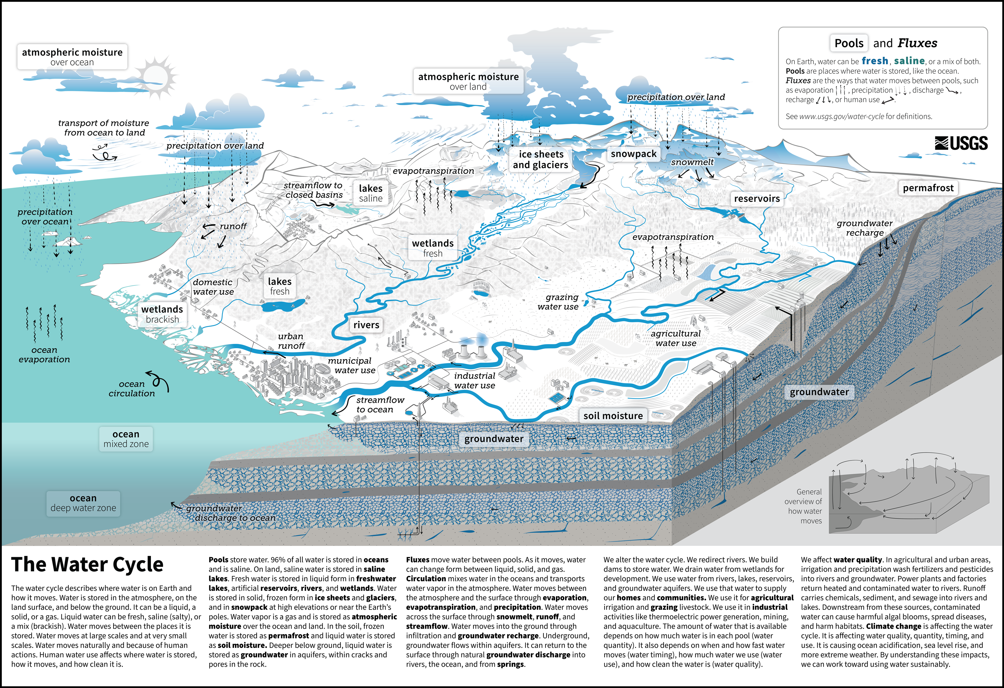
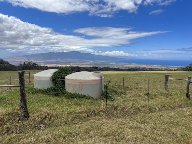
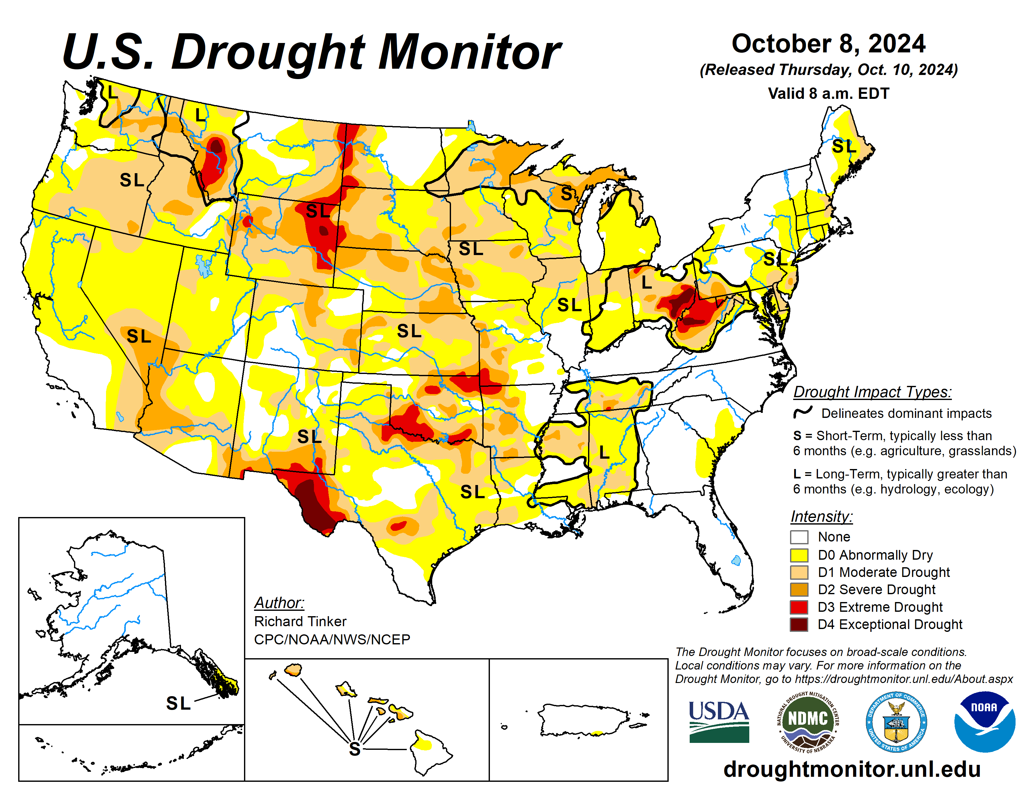
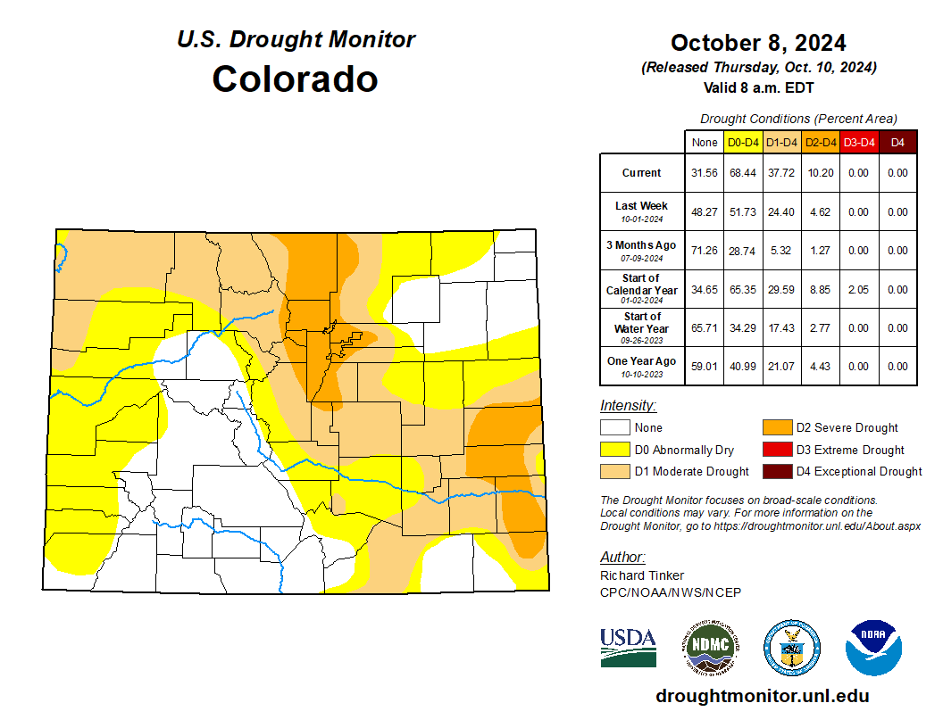
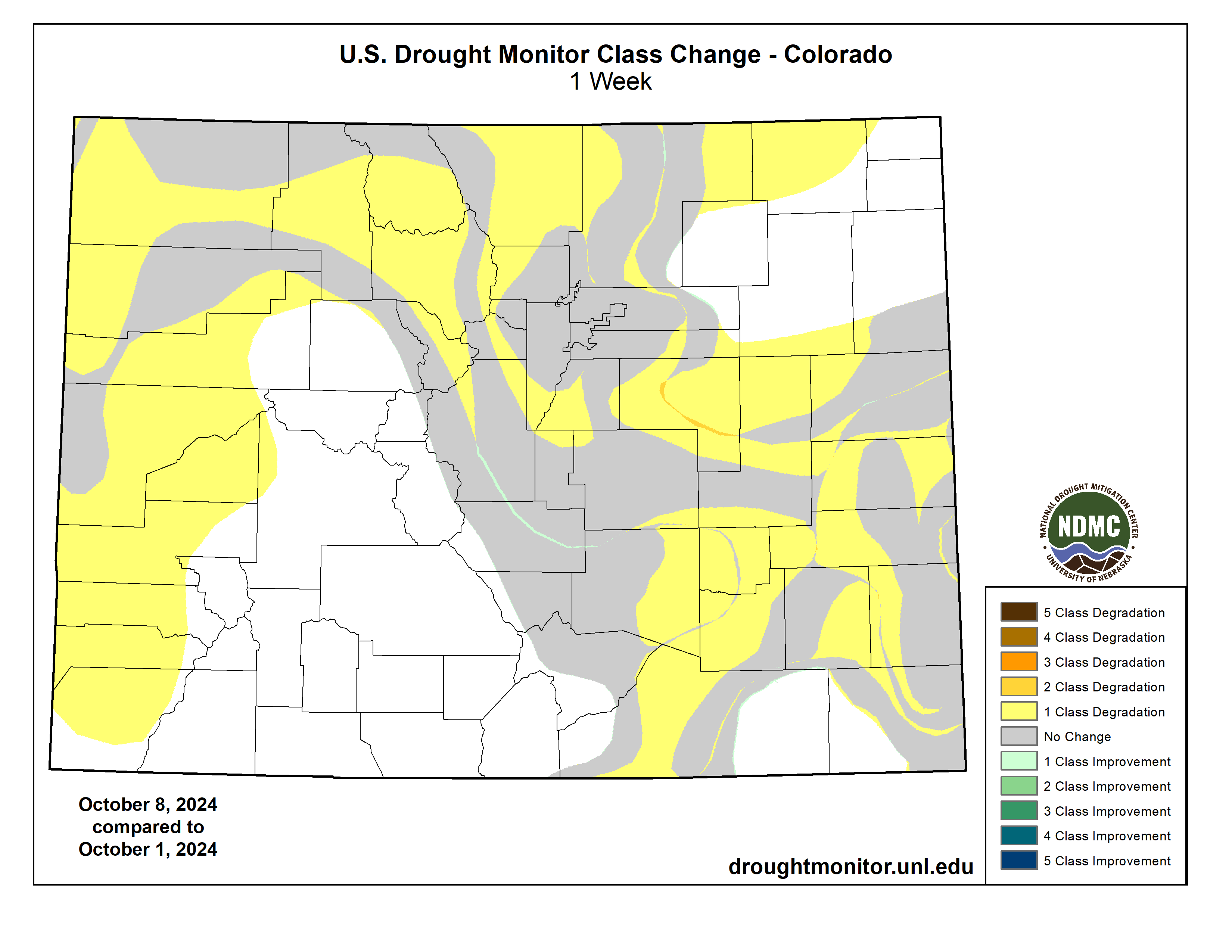
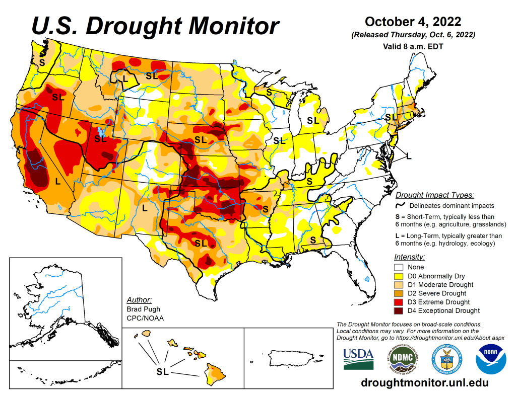
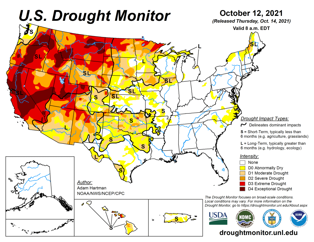
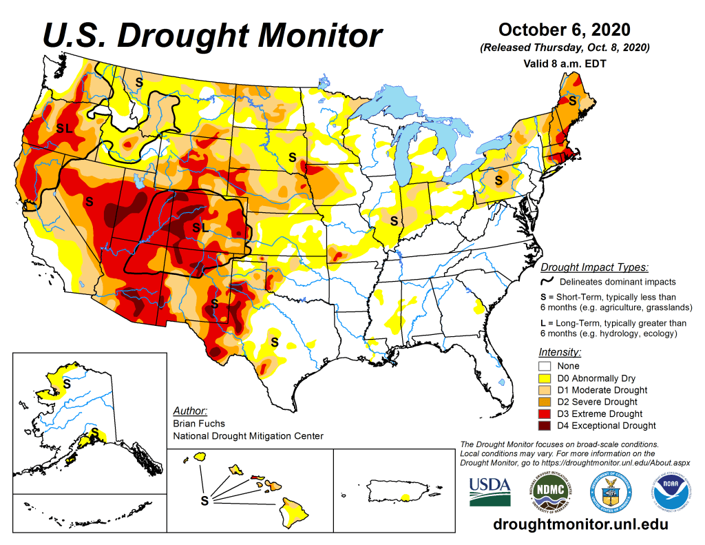
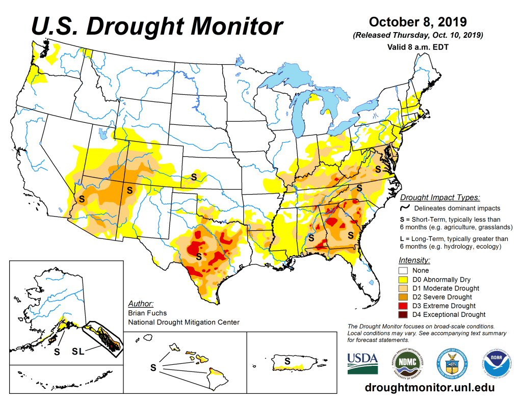
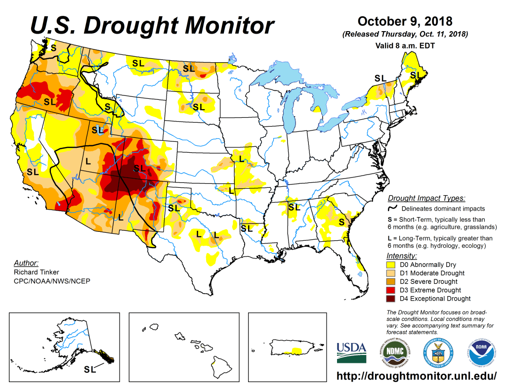
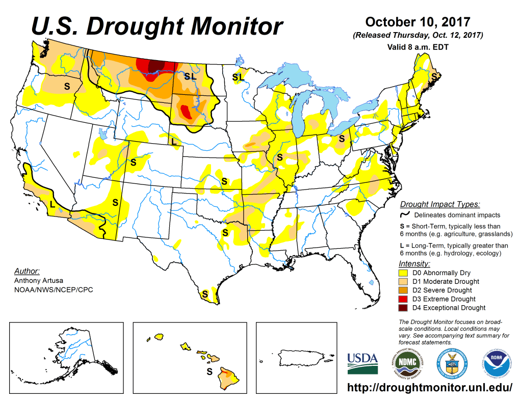
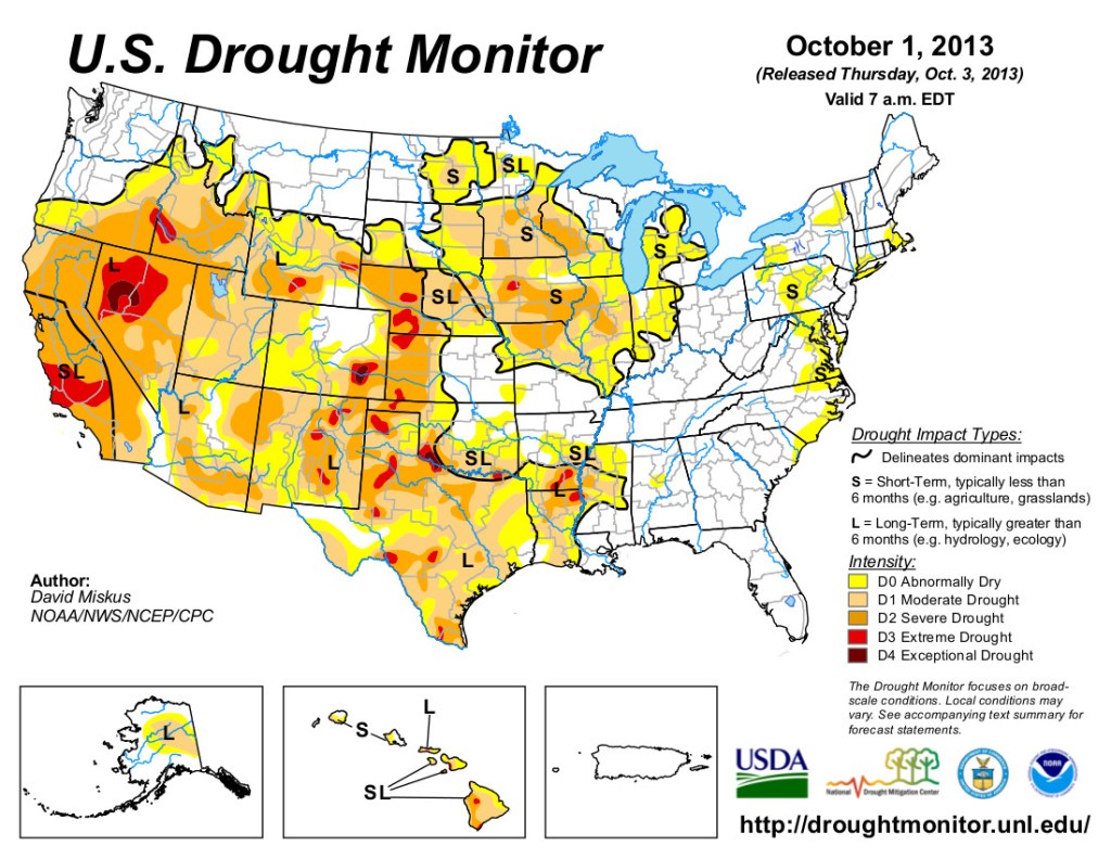
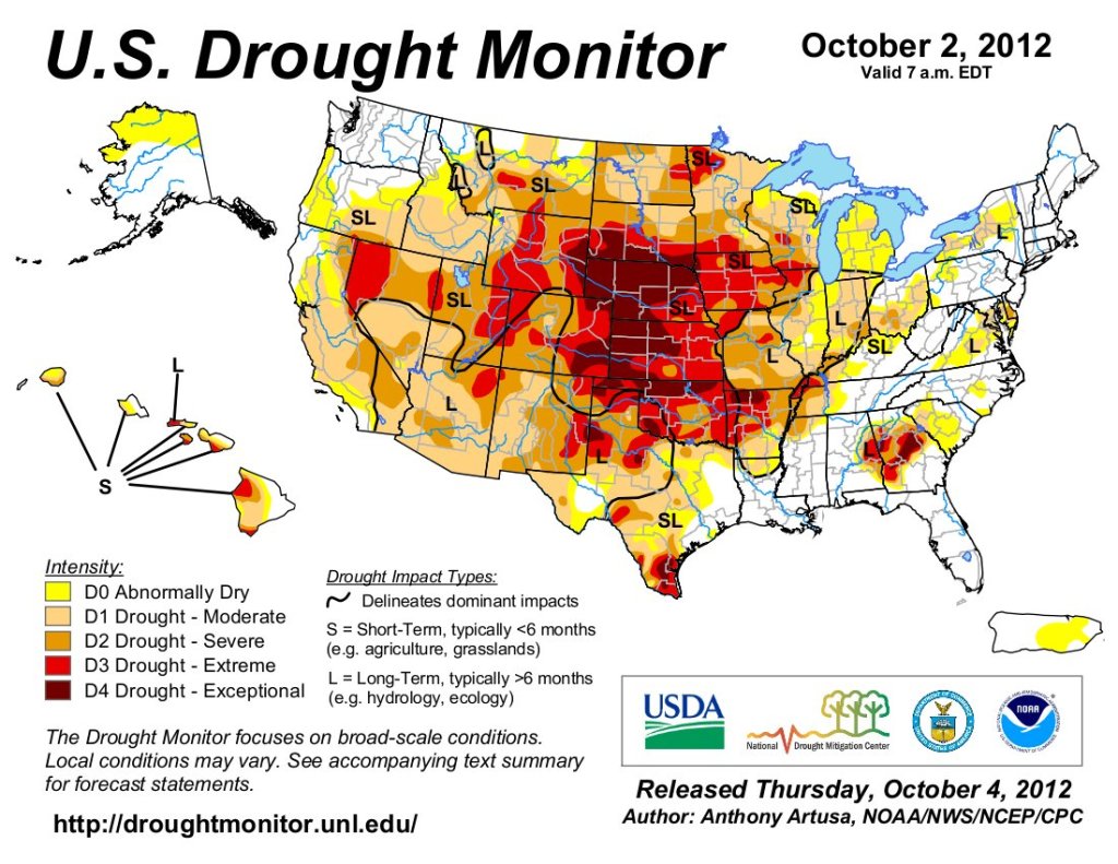
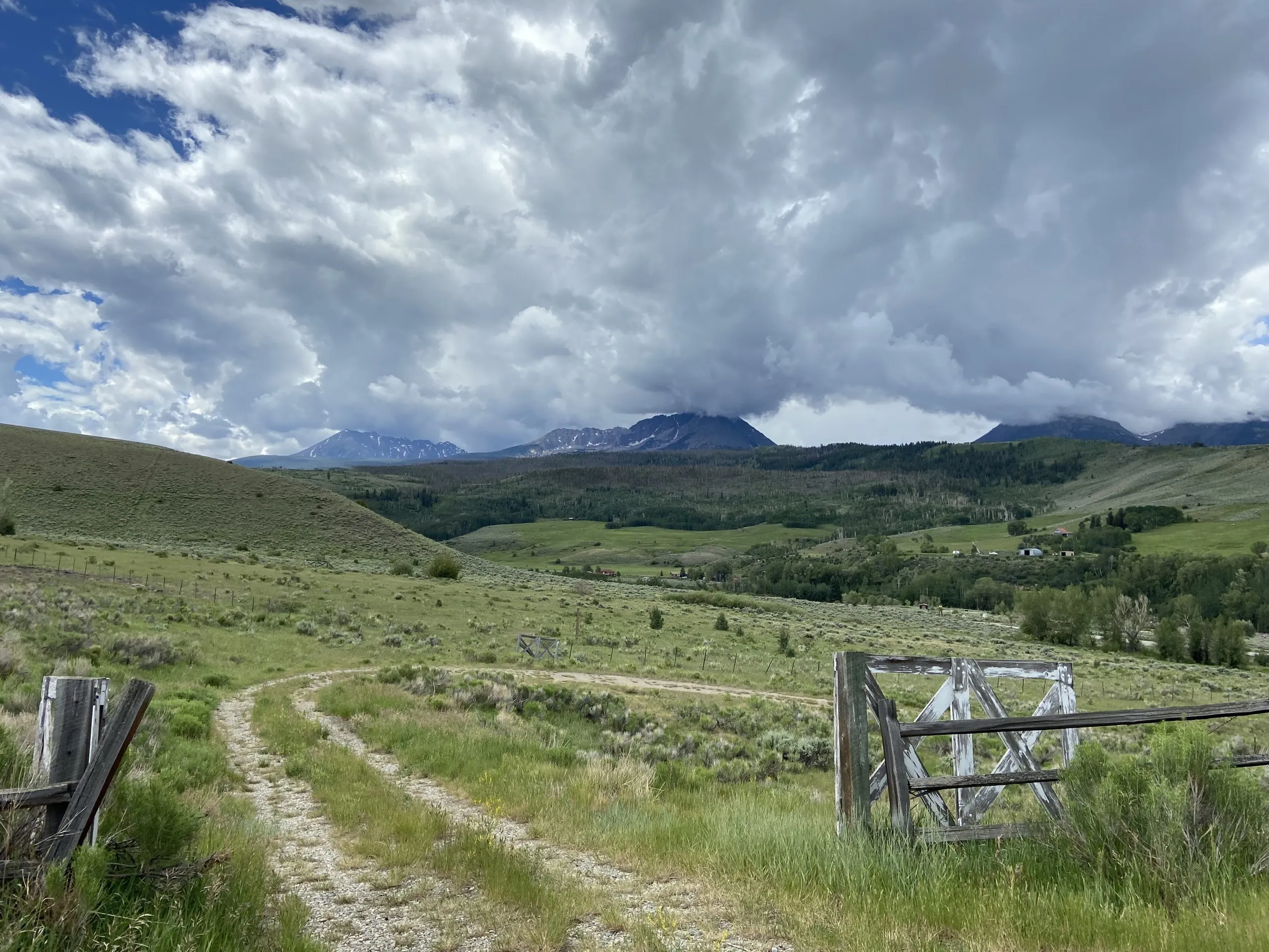
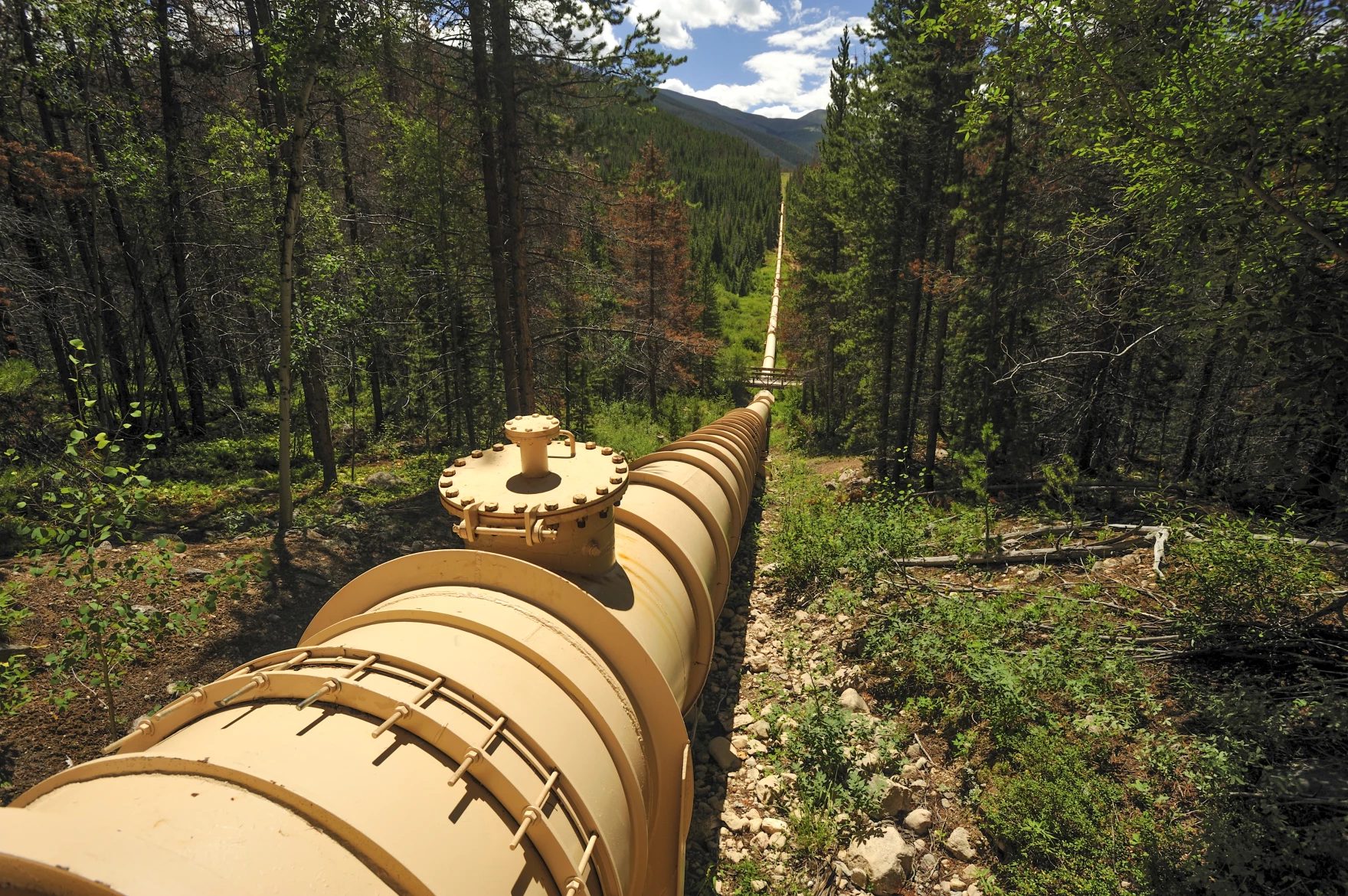
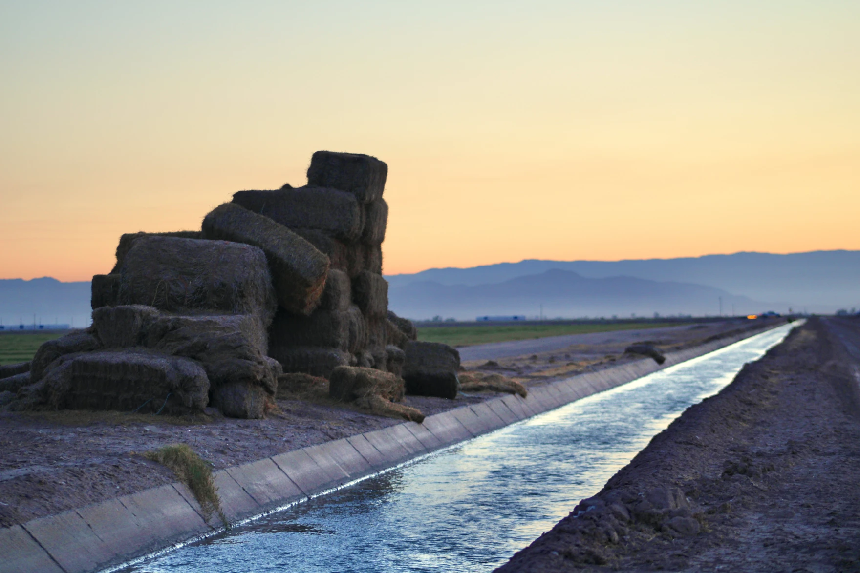
Water is required for cooling, heating, washing, diluting and other processes at nearly 6,000 manufacturing facilities in Colorado. As historic droughts threaten water availability across the state, consumers increasingly demand water-smart practices, and inflation continues to squeeze the private sector, many manufacturers are shifting their approach to water use and conservation.

โ€œManufacturers are increasingly becoming good stewards of water,โ€ says JC Ye, corporate business director of water reuse at Veolia, a global water services company. โ€œMany have a strong incentive to implement water stewardship practices and invest in improving the reliability of water supply. In most industrial processes, disruption of water availability has an immediate, acute impact on manufacturing operations.โ€

But water is highly contextual. Every river and stream has a unique ecosystem and different needs depending on the season. Solutions to protect and restore these resources are just as complex. Companies are taking a variety of approaches to water stewardship, from investing millions in local conservation work to making small but impactful infrastructure upgrades.

Leprino Foods processing facility. Photo Courtesy Leprino Foods

A reputational imperative

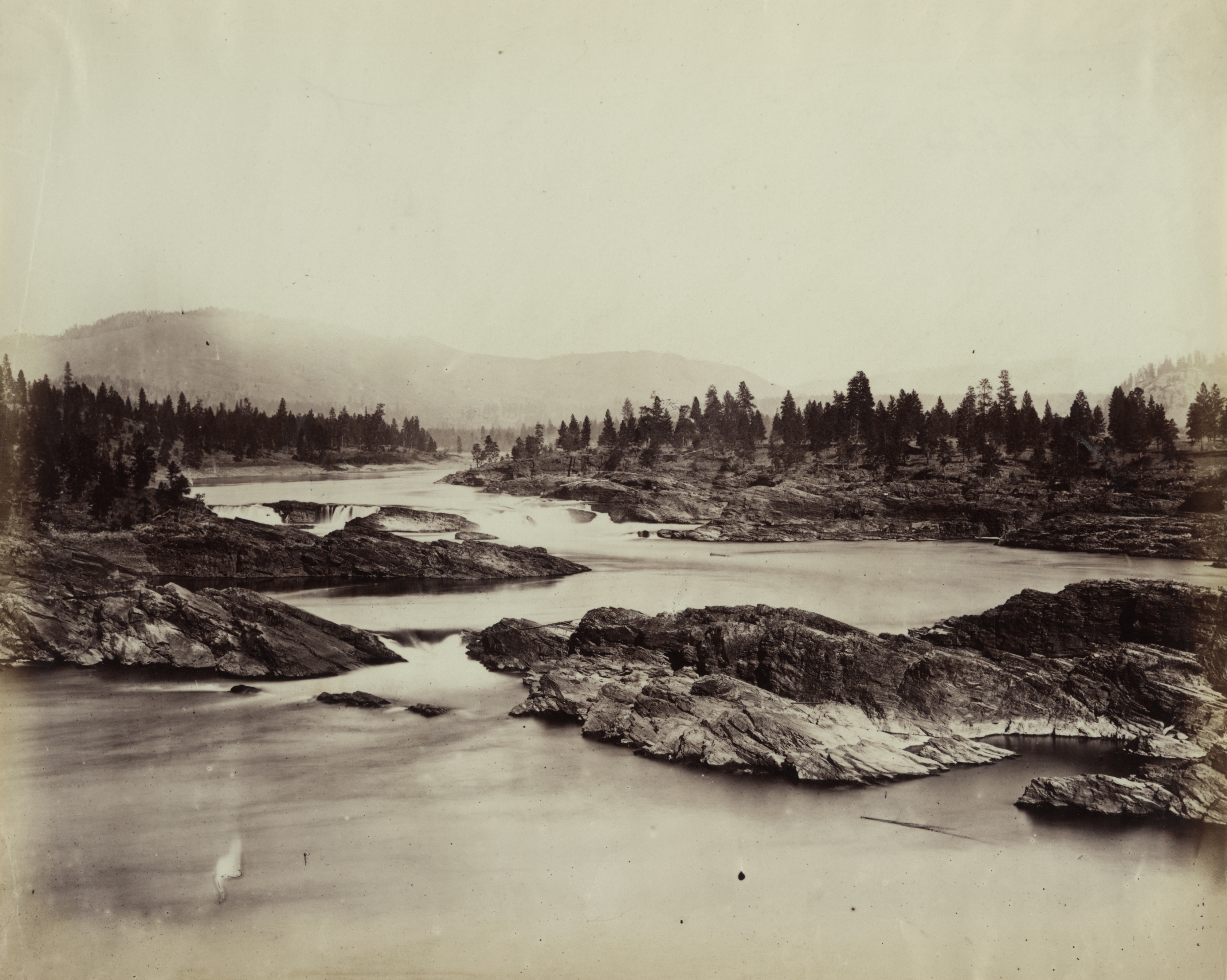
The original Coors brewery was built in Golden specifically for Clear Creekโ€™s remarkable water quality. The company has a history of conducting projects aimed at protecting this water, which ends up in its product. As a founding member of the Clear Creek Watershed Foundation, the Molson Coors Beverage Company has helped to clean up some of the estimated 1,600 orphaned mines in the watershed, which threaten water quality by overflowing and discharging heavy metals and mine drainage into the river.

These days, water stewardship is about both public perception and product quality: Consumer-facing brands like Coors know that they face a reputational risk if they donโ€™t invest in water-use reduction and watershed protection.

โ€œ[People] need to have confidence that we are serious about our water use, that weโ€™re serious about protecting the watershed,โ€ says Ben Moline, director of water resources and environmental policy for Molson Coors Beverage Company.

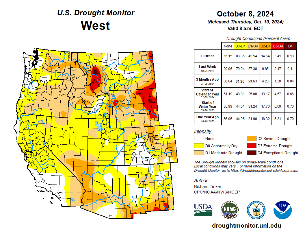
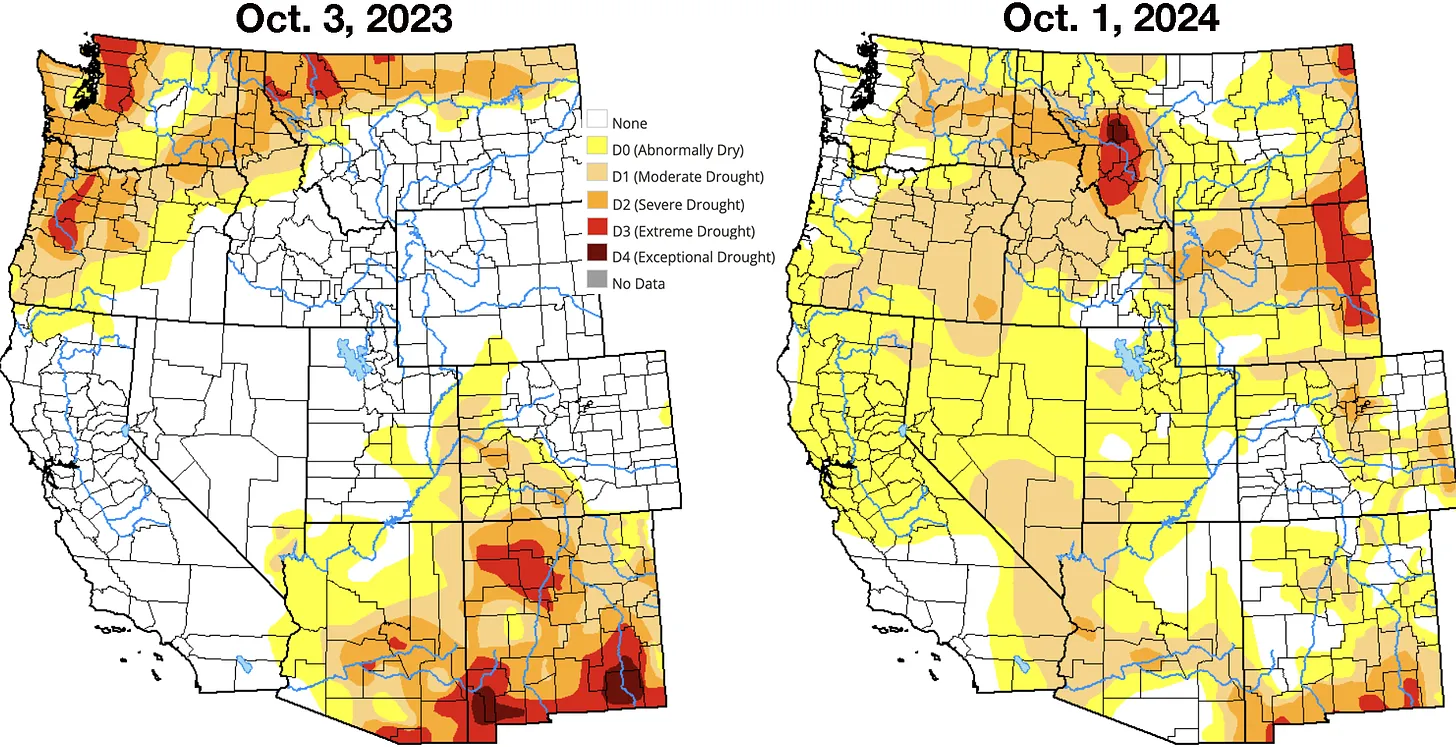
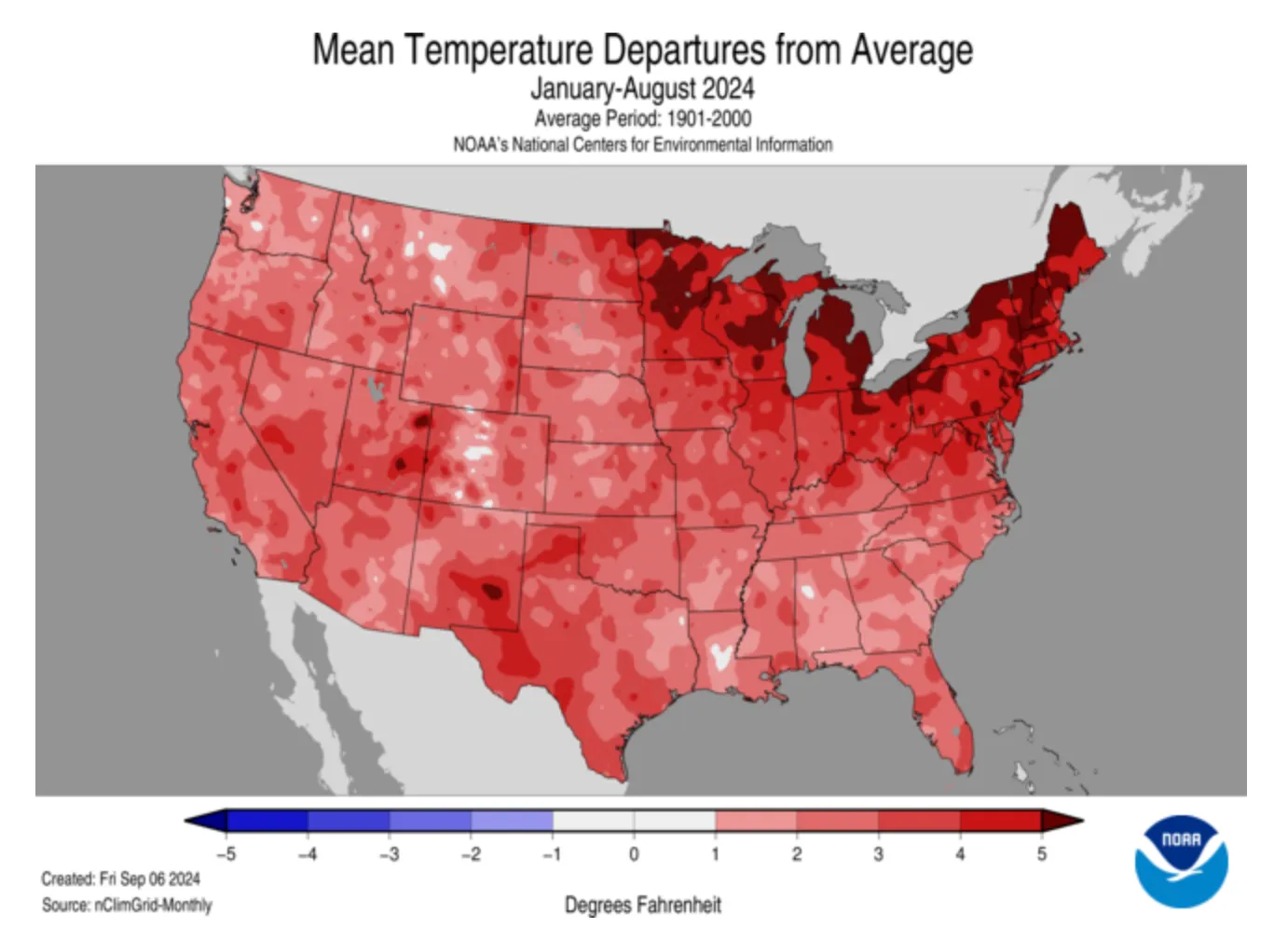
The entire state of Colorado has experienced severe to extreme drought on and off for more than two decades. The public is watching water use more closely as resource scarcity becomes a more serious concern. Recently, some communities have pushed back against water consumption for manufacturing.

BlueTriton โ€” the owner of major U.S. bottled water brands, including Poland Spring โ€” has been embroiled in legal battles with water boards, environmentalists, and other activists across the country for years. The company pumps water from Coloradoโ€™s Upper Arkansas River Basin, a semi-arid region particularly impacted by historic drought. In July 2021, about 20 community members protested outside of the Chaffee County Courthouse, opposing the renewal of a permit that allows BlueTriton to export 65 million gallons of water per year. After negotiating more than $1.25 million in community contributions from BlueTriton, county commissioners approved the permit the following month.

Veolia found in a 2023 study that fewer than 30% of surveyed companies had set water conservation goals, with water lagging behind carbon and waste as the environmental priority for companies. But Ye notes a recent shift in the way companies approach sustainability. Water scarcity concerns, public pressure, reputational risk, and cost-saving opportunities are leading to the proliferation of water initiatives across the private sector.

Michael Kiparsky, founding director of the Wheeler Water Institute at the University of California Berkeley School of Law, sees this as an opportunity: โ€œCan we use transparency coupled with some degree of public awareness of water as a resource to put pressure on corporate entities to do something that might not be strictly in their economic interest otherwise?โ€

Small changes, big impact

The Coors brewery in Golden uses an estimated 2.7 billion gallons of water from Clear Creek each year: about 782 million gallons for its products, and 2 billion gallons for brewing processes, including production and malting. Of those 2 billion gallons of process water, 95% is cleaned and returned to Clear Creek.

This is representative of manufacturers at large: According to the Colorado Water Plan, industrial users account for only 3% of Coloradoโ€™s total annual water consumption, or water that is permanently removed from its source.

โ€œWe are diversion heavy, but depletion light,โ€ says Moline, noting that Molson Coors is actively working to bring its water consumption rate even lower, while continuing to work with the Colorado Department of Public Health and Environment (CDPHE) to ensure wastewater discharged back to Clear Creek after treatment meets permit requirements.

Molson Coors treats wastewater from its operations as well as much of the City of Goldenโ€™s wastewater. The company entered into a consent order with CDPHE earlier this year to address permit exceedences for total suspended solids, metals, oil and grease, and whole effluent toxicity in its discharge water. Even before the consent order, the brewery began upgrading its wastewater treatment plant in preparation for meeting tightening water quality limits. Water treatment improvements are big changes with big impact, but small infrastructure changes also lead to big results โ€” for example, fermentation tank design.

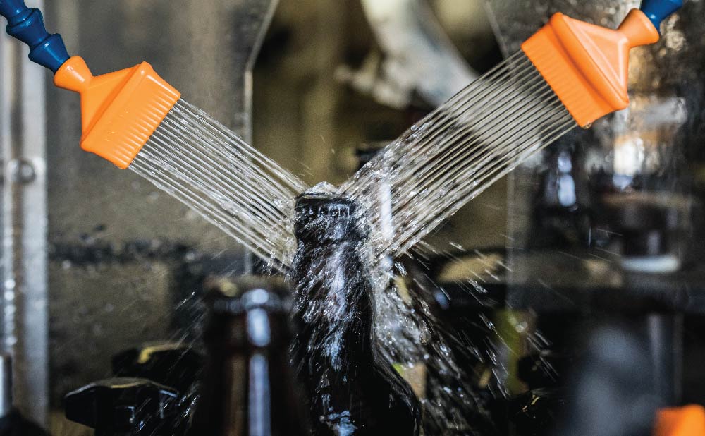
A few times per month, depending on the type of beer, the brewing team empties each fermentation tank through a valve on its side, leaving a small amount of beer just below the valveโ€™s opening. The team clears the excess beer and thoroughly cleans the floor of the tank to prepare for the next batch, using water and a squeegee multiple times over. Across more than 100 fermentation tanks of varying sizes, which produce approximately 9.7 million barrels of beer per year, a portion of beer is lost in the cleaning process.

Molson Coors Beverage Company is updating its fermentation tanks to a new, vertical design with a cone-shaped bottom, through which a valve completely empties the beer directly below the tank. Now, the brewery can produce the same number of barrels for less, because beer โ€” and water โ€” isnโ€™t left on the tank floor. This means less water used for malting, heating and cooling beer that ultimately doesnโ€™t make it to consumers, and less water used in the cleaning process.

The upgrades are a part of Molson Coors Beverage Companyโ€™s G150 project, in honor of the 150-year anniversary of the Coors breweryโ€™s inception. The company has invested โ€œseveral hundred million dollarsโ€ in the project, which is expected to save 80 million gallons of water annually after its completion by the end of 2024. Moline says that upgrading its fermentation tanks is contributing a large part of these water savings.

Other food and beverage manufacturers are updating infrastructure to save water: Swire Coca-Cola, which produces, sells, and distributes Coca-Cola and other beverages in 13 states across the American West, says that it installed a new filtration and recovery system at its Denver plant to reduce water usage by about 20%. And Bellvue-based Morning Fresh Dairy, a fifth-generation dairy farm that produces the nationally popular Noosa Yogurt brand, installed an automated clean-in-place system to clean the interior of food and beverage process pipes, reducing water consumption by 30%.

Corporate mandates

PepsiCo, Amazon, Google and Facebook have all committed to being water-positive, or replenishing more water than they use from natural systems, by 2030. In addition to water-efficiency projects, much of this work is done through cross-sector partnerships, which have provided critical support to local water stewardship efforts.

โ€œCorporate support has been very important to our ability to staff project work and, even more so, to purchase water for streamflow restoration,โ€ says Kate Ryan, executive director of the Colorado Water Trust.

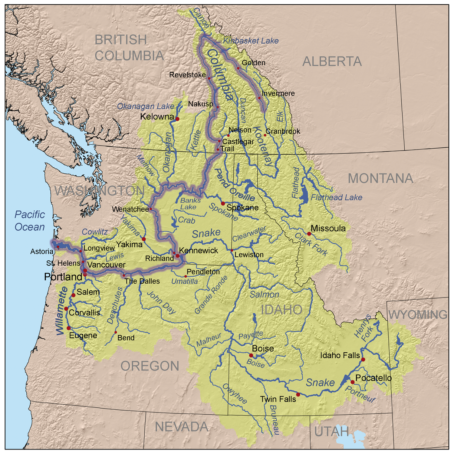
For example, the tech giant Intel relies on the Colorado River and the Rio Grande to supply water downstream to its Arizona and New Mexico manufacturing facilities. The company has partnered with the Colorado Water Trust and Trout Unlimited on multiple projects to support the Colorado River watershed. Intel reports that 120% of the water it used across the U.S. in 2023 was either returned to the source or restored through investment in water stewardship projects.

The Colorado Water Trust has received more than $421,000 in corporate funding from companies like Intel, Coca-Cola, MCBC, Seltzer, and Niagara Cares, a philanthropic arm of Niagara Water, since 2019. This money, in addition to foundation funding, individual contributions, and water donations, has enabled the organization to lease well over 10,000 acre-feet of water, which would typically cost $400,000 to $2,500,000, depending on the water right, says Ryan. The projects improved flows on the 15-Mile Reach of the Colorado River โ€” a critical stretch of river for endangered fish species near Grand Junction, Colorado โ€” as well as on the Yampa River and tributaries to the Fraser River.

And while BlueTriton has received pushback from community members on its water use, the company has partnered with Colorado Parks and Wildlife to dedicate a conservation easement to preserve 122 acres of wildlife habitat and protect groundwater resources along the Arkansas River.

โ€œThese sustainability programs work well, and Western rivers would benefit from more of them,โ€ says Ryan. โ€œThe amount of water they have made possible for streamflow restoration in recent years is significant.โ€

But experts agree that the pathway to meet water-positive goals, or even water-neutral goals, is not straightforward.

Context is key

A Colorado Water Trust project benefits the Little Cimarron River using a senior water right that keeps productive land irrigated in a split-season arrangement, where water is applied to fields in the first part of the season, then left in the river during later summer months when fish need it most. The trust also partners with corporations, such as Coca Cola, to secure funding for water conservation work. Courtesy Colorado Water Trust

โ€œBeing โ€˜water neutralโ€™ in an honest way requires a great amount of thought and engagement with people who have direct interest or represent the interest of the communities and environment that might be affected,โ€ says Kiparsky.

In 2023, the nonprofit Ceres published a benchmark analysis of 72 companies from four water-intensive industries โ€” apparel, beverage, food, and high-tech โ€” and found that only 35% consider contextual factors such as local watershed conditions, regulatory dynamics, and community water needs when assessing water use risks. Only 14% consider contextual factors when assessing water quality risks.

โ€œ[We] found that while many companies are setting goals aimed at using less water, most are not setting strong targets to reduce water pollution,โ€ says Kirsten James, senior program director for water at Ceres. โ€œWe also noted a lack of commitment around protecting freshwater ecosystems and clean water supplies for communities.โ€

Where and when water is replenished makes a significant difference for water systems. Simply measuring the amount of water a company uses and returns to its source each year, for example, does not account for when that water was used or returned. If most water is pumped during the summer and returned during the winter, these activities could still be disruptive to wildlife, ecosystems, and overall river flow rates.

โ€œUnlike in sustainability efforts involving carbon offsets, there is no single atmosphere to improve. Every river has different needs at different times of the year,โ€ says Ryan.

Implementation of corporate water goals requires detailed reporting and independent validation to ensure the efforts are sustaining or restoring and not damaging ecosystems.

โ€œItโ€™s a simple concept, becoming water neutral, but putting it in practice is not simple,โ€ says Kiparsky. โ€œA lot of the implications are going to rely on analysis by third parties that are experts in understanding water impact.โ€

This year, the U.S. Securities and Exchange Commission (SEC) began requiring most public companies to disclose climate-related information, including water-related financial risks, so investors can consider how companies are managing climate risks when making investment decisions. James says this is an important step that will help raise the bar with U.S. companies on water-related disclosures.

โ€œAs water risk continues to escalate, investors and companies need full transparency to be able to manage and adapt to these threats,โ€ says James.

What tribal leaders think about Interiorโ€™s dams report: The federal government has acknowledged the harms of #ColumbiaRiver dams. Now what? — @HighCountryNews

Kettle Falls in 1860. By Unknown author – Library of Congress archives at http://hdl.loc.gov/loc.pnp/ppmsca.03399, Public Domain, https://commons.wikimedia.org/w/index.php?curid=3923552

Click the link to read the article on the High Country News website (B. โ€˜Toastieโ€™ Oaster):

September 1, 2024

There was a time you could catch tons of salmon in a single day at Kettle Falls, a series of pools cascading into each other on the Columbia River in northern Washington. That was before the U.S. government built Grand Coulee Dam in 1942. After 82 years, in June of this year, the Department of Interior published Historic and Ongoing Impacts of Federal Dams on the Columbia River Basin Tribesan analysis that explores how 11 hydropower dams on the mainstem Columbia, Snake and North Fork Clearwater rivers have hurt Indigenous economies, cultures, spiritual practices, environments and healthThose historic and ongoing harms include the destruction of important cultural sites like Kettle, as well as Celilo Falls, another ancient fishery that was also a magnificent international marketplace. Dams are also famously driving the basinโ€™s salmon stocks toward extinction. โ€œOf sixteen once existing salmonid stocks, four have been extirpated โ€” Mid-Columbia River Coho, Mid-Columbia River Sockeye, Upper Columbia River Coho, and Snake River Coho,โ€ the report reads. All but five of the remaining stocks are now endangered or threatened. 

Indigenous people have long known about the damage dams cause, but to hear the federal government admit it is another thing. HCN spoke to Shannon Wheeler, chair of the Nez Perce Tribe; Phil Rigdon, superintendent of the Natural Resources Department at the Confederated Tribes and Bands of the Yakama Nation; and Corinne Sams, whoโ€™s on the board of trustees for the Confederated Tribes of the Umatilla Indian Reservation and is also chair of the Umatilla Fish and Wildlife Commission and the tribal nationโ€™s representative at the Columbia River Inter-Tribal Fish Commission. Hereโ€™s what they have to say about Interiorโ€™s report.

These conversations have been edited for brevity and clarity.

High Country News: What was tribal involvement in creating the Interior Departmentโ€™s report?

Shannon Wheeler: We are the ones that submitted (it) to them. We had already completed this in the 1990s. We revamped it and gave them the newest version over the past eight months, and thatโ€™s what they have been working (from).

Corinne Sams: Weโ€™ve always been heavily engaged with the Department of Interior, along with the recent Columbia Basin Restoration Initiative, which is now being called the Resilient Columbia Basin Agreement, with the United States government. That was solidified in January of this year. Over the last three years, Umatilla Tribe and our staff have worked vigorously to ensure that the United States government understands the impacts and the losses that have occurred to salmon and other anadromous fish within the Columbia and Snake Basin. So weโ€™ve played an enormous role.

Phil Rigdon: The Department of Interior came, and we did a consultation with the federal government on (the report). Our leadership expressed concerns (about) the impacts that the dams have had on our salmon, lamprey, sturgeon and fish species, but also the knowledge of our connection to the Columbia River. Our lives have changed forever, ever since those (dams) were in. But we continue to advocate and go fish and continue to practice our culture and our way of life. This report comes out in a manner that highlights a lot of broken promises to our people, but we continue to push and advocate on behalf of resources that we hope will be returned back to the levels they should be

HCN: Is there anything you think the report gets wrong or leaves out?

SW: No.

CS: No. This is the first time the federal government has ever recognized the true impacts to our people and to our ecosystem in regard to hydro systems, so weโ€™re very optimistic and encourage individuals to read the report, to become informed. Because our ultimate goal is to decarbonize and replace the energy sector, which will eventually, hopefully, replace those hydro systems. We recognize that this isnโ€™t only about fish. We have several other interests in the basin: transportation, recreation, irrigation. All of those components are important, and we donโ€™t want to leave one out. Weโ€™re really pushing for everybody within the basin to remain whole. 

PR: These reports are important. But sometimes (itโ€™s) tough to understand the heart of it. Our people are still down (there) fishing right now. Our people continue to carry our way. But the report is an important step into highlighting those things that we consider problematic over the history of the dams.

HCN: What kinds of federal actions do you want to see based on this report?

SW: Consideration for breaching of the four Lower Snake River dams.

CS: Thereโ€™s a billion-dollar backlog on infrastructure and hatchery maintenance, and we utilize those hatcheries as mitigation fish, for the loss of the abundant natural runs. But our ultimate goal is to get our natural runs back to healthy and harvestable levels. Weโ€™ve done a significant amount of work and have been co-managing these resources (with government agencies) for decades, but the tribes have been managing these resources for millennia. This isnโ€™t just a tribal effort. This is for all Americans that live within the basin.

PR: Thereโ€™s Bateman Island Causeway down at the mouth of the Yakima (River) that causes the thermal block that causes enormous problems for juvenile and adult fish migration up to the Yakima Basin. The small things really need to be invested in and done now. Some of these things that have been a problem for a long time are critical. And then to look at the big things, like the Lower Snake River dams, and really come up with solutions. But we also believe it canโ€™t be like it was for us. We canโ€™t leave people behind in the manner that we were left behind, putting the dams in for the energy development. There is a balance here that needs to be achieved through what these reports do, but also what weโ€™re trying to do as a people.

HCN: Do you think any federal action hinges on Democrats winning the upcoming presidential election?

SW: Tribal nations across the country have all had impacts one way or another regardless of what type of administration is in. But I also believe that this administration understands that thereโ€™s impacts that the United States has had on its people.

CS: Absolutely. If we see a shift in administration, all of these agreements, all of these reports, become uncertain.

PR: I think itโ€™s not important. Republicans fish, and Democrats fish, too. We need to come together to find solutions. I donโ€™t think we should make it all dependent on who wins an election, but we should be thinking about how we solve long-term problems. The polarization that you see is sad, in a lot of ways, because I donโ€™t think weโ€™re getting to the right conversations. I donโ€™t think we want to go political. I have red-state Republicans advocating for our work in the Yakima. Thatโ€™s unique because of our partnerships, but also how weโ€™re trying to build trust within our local communities. Weโ€™re from rural communities, rural America, tribal people. Sometimes weโ€™re less concerned about the politics. Weโ€™re thankful for the Biden administration and the leadership theyโ€™re showing in doing these studies. I donโ€™t want to discount that at all. But we want to make sure itโ€™s not dependent upon who gets elected, but that we continue moving forward as a people.

Native salmon fishermen at Celilo Falls. Russell Lee, September 1941. By Russell Lee – This image is available from the United States Library of Congress’s Prints and Photographs divisionunder the digital ID fsa.8c22374.This tag does not indicate the copyright status of the attached work. A normal copyright tag is still required. See Commons:Licensing., Public Domain, https://commons.wikimedia.org/w/index.php?curid=3923525

HCN: Do you think thereโ€™s a path here to bringing back Celilo Falls?

CS: When they inundated Celilo Falls, several years after that they did sonograms. And they say the falls are still under there. I think deep in our hearts we always hope to see the return of that fishery, that place. Our ancestors and our old people talk about just the sound alone, the sound of those falls. They miss that sound. 

PR: I would love to see that. I donโ€™t want to get our hopes up, either.    

We welcome reader letters. Email High Country News at editor@hcn.org or submit a letter to the editor. See our letters to the editor policy.

This article appeared in the September 2024 print edition of the magazine with the headline โ€œWhat tribal leaders think about Interiorโ€™s dams report.โ€

Map of the Columbia River watershed with the Columbia River highlighted. By Kmusser – self-made, based on USGS and Digital Chart of the World data., CC BY-SA 3.0, https://commons.wikimedia.org/w/index.php?curid=3844725

Denver measures second hottest summer on record: โ€œFour of the top five are in the last five yearsโ€ — The #Denver Post

Colorado Drought Monitor 6 month change map ending October 8, 2024.

Click the link to read the article on The Denver Post website (Bruce Finley). Here’s an excerpt:

September 4, 2024

This summer in metro Denver ranks as the second hottest on record, in line with global warming, according to theย National Weather Service. A hot, dry July extended through August. While much of northcentral and northeastern Colorado had above-normal rain in August, most of the metro Denver area received less than 1.5 inches. High temperatures reached 100 degrees on six days and topped 90 degrees on 57 days as of Tuesday,ย weather service recordsย from June 1 through August 31st show. Denverโ€™s average summer temperature measured 75 degrees โ€” which is 2.7 degrees above the norm, meteorologists said. Only the summer of 2012 measured hotter, with an average temperature of 76.3 degrees. The other three hottest summers occurred in 2020 (74.9 degrees), 2021 (74.6 degrees), and 2022 (74.8 degrees).

โ€œFour of the top five are in the last five years, and number one was 12 years ago,โ€ NWS meteorologist Paul Schlatter said. โ€œWe keep breaking temperature records globally. Same thing in Denver, especially in the summer. Weโ€™re matching what is happening on a global scale. Some parts of the world are warming faster than others. It is definitely hitting our summers.โ€

Metro Denverโ€™s night temperatures generally cooled off with an average of 59.2 degrees this summer, records show. The governmentโ€™sย drought indexย on Wednesday designated 40% of Colorado as โ€œabnormally dryโ€ withย  8.5% of the state registering in drought.

Opinion: Time is now for a new #ColoradoRiver Basin process to bring together and engage sovereigns and stakeholders — Lorelai Cloud #COriver #aridification

Animas River. Photo credit: The Southern Ute Indian Tribe

From email from John Berrgren:

August 15, 2024

The foundation of the laws, treaties, acts and policies that govern the Colorado River is the Colorado River Compact of 1922. Over the past 100 hundred years, dozens of additional agreements and decisions have been layered on top, providing for the management framework we know today. 

As we look to the future, and as individuals who represent Tribal and environmental interests in the Colorado River Basin, we believe it is time to return to โ€” and reimagine โ€” one of the primary stated purposes of the 1922 Compact: to provide for the equitable use of water.

For me, Lorelei, itโ€™s personal. Rooted in the Southern Ute Indian Tribe and raised on the Reservation in southwestern Colorado, my life has been deeply intertwined with water. 

We lived in one of the first adobe houses on the Reservation and did not have running water. We relied in part on groundwater, but the well often dried up. So, we hauled water once a week and my grandmother boiled ditch water for drinking water as needed. 

Water was a scarce resource, and we often had to choose between using water for drinking, taking showers or flushing the toilet. This scarcity is still a reality for many Native Americans today across the country.

I grew up knowing that water is a living, sacred being. Our Ute (Nuuchiu) culture centers around water, and we offer prayers for and with it. Water is the heart of our ceremonies. We were taught early on to take and use only what is needed. Above all else, we must care for the spirit of the water.

From the 2018 Tribal Water Study, this graphic shows the location of the 29 federally-recognized tribes in the Colorado River Basin. Map credit: USBR

When I was first elected to the Southern Ute Tribal Council in 2015, I was asked to participate in the Ten Tribes Partnership, or TTP, which is a coalition of the 10 Tribes along the Colorado River focused on securing and using tribal water. After one year, I was asked to chair TTP.

I drew on my personal and spiritual connection to water and started learning about the complex legal and technical issues related to managing water in the American West. I was stunned to learn that Tribes have historically delegated to have little to no role in managing Western water, and that tribal needs and interests are often marginalized.

In recent years, I have had the opportunity to work alongside many people from diverse walks of life to begin addressing these inequities: lack of inclusion in decision-making; lack of access to clean water; and lack of capacity to manage, develop and use water. 

I became a founding member of the Water and Tribes Initiative, or WTI, for the Colorado River Basin; was the first Native American appointed to the Colorado Water Conservation Board and the Colorado Chapter of The Nature Conservancy; co-founded the Indigenous Womenโ€™s Leadership Network, a program of WTI; and helped forge an historic agreement among the six tribes in the Upper Basin the Colorado River and the states of Wyoming, Colorado, Utah, and New Mexico to allow Tribes to be more meaningfully involved in collaborative problem-solving (but not decision-making per se).

Like Tribes, environmental interests have mostly taken a backseat to the use of the Colorado River for municipal and agricultural purposes. Most adjustments to address cultural and ecological values have been treated as subservient to the allocative laws that largely service municipal and agricultural interests.

Returning to the primary purpose of the 1922 Compact, we believe that providing for the equitable use of water includes substantive and procedural elements. Thereโ€™s a huge difference between how the Colorado River is managed for multiple values (substance) and how people who care about such issues determine what ought to happen (process). 

We are offering a process improvement. We believe itโ€™s time to establish an ongoing, whole-basin roundtable that would embrace the entire transboundary watershed, address the major water issues facing the basin, and, importantly, provide an equitable process to engage all four sets of sovereigns (United States, Mexico, seven basin states and 30 Tribal nations), water users and stakeholders. 

The late University of Colorado law professor David Getches, an astute observer of Colorado River law, noted in 1997 that โ€œthe awkwardness and the intractability of most of the Colorado Riverโ€™s problems reflect the absence of a venue to deal comprehensively with Colorado River basin issues.โ€ He called for โ€œthe establishment of a new entity that recognizes and integrates the interests and people who are most affected by the outcome of decisions on major Colorado River issues.โ€ 

Many other scholars and professionals have supported a whole-basin approach to complement, not duplicate, other forums for engagement and problem-solving in the basin. Establishing a whole-basin forum is also consistent with international best practices, as most transboundary river basins throughout the world have some type of river basin commission.ย 

A whole-basin forum would be a safe place to have difficult conversations, to exchange information, build trust and relationships, and to develop collaborative solutions. It should rely on the best available information, including Indigenous knowledge.

Addressing the historic inequities built into the fabric of governing the Colorado River requires innovative substantive tools as well as procedural reforms focused on engagement and problem-solving. We look forward to working with all of you to shape a more equitable, more sustainable future for the Colorado River.

Vice Chairman Lorelei Cloud lives on the Southern Ute Indian Reservation and is the first Native American appointed to the Colorado Water Conservation Board and the Colorado Chapter of The Nature Conservancy.

John Berggren lives in Boulder and is the Regional Policy Manager, Healthy Rivers for Western Resource Advocates.

Map credit: AGU

Aurora Borealis images from northern #Colorado October 10, 2024

Two of my colleagues at the City of Thornton granted me the permission to use the photos below.

Northern Lights from northern Colorado near Thornton October 10. 2024. Photo credit: Matt Stockton
Northern Lights from Nunn October 10, 2024. Photo credit: Karen Langston

Water Year 2024 Brought Record-Breaking Temperatures and Varied Precipitation to the Intermountain West, Leading to a Mix of #Drought Degradation and Improvement — NIDIS

Click the link to read the article on the NIDIS website:

October 10, 2024

Key Points

  • Water Year 2024 overall was warmer than normal across the Intermountain West, with variable precipitation across the region, contributing to drought development in Wyoming and limiting drought amelioration in southern New Mexico.ย 
  • Drier-than normal-conditions were noted in northwestern Arizona, southern New Mexico, western and southwestern Utah, north-central and southeastern Colorado, and eastern and southern Wyoming.ย 
  • Wetter-than-normal conditions were logged in northern portions of New Mexico, much of the southern Rockies of Colorado, areas of central and west-central Utah, and parts of northwestern Wyoming.ย 
  • Overall, the 2024 North American Monsoon season precipitation underperformed in Arizona and southern/western New Mexico and overperformed in eastern and northern Utah, northern New Mexico, and all but the Front Range and eastern Rockies of Colorado.
  • As of October 7, 2024, El Niรฑo-Southern Oscillation (ENSO) neutral conditions are expected to transition to La Niรฑa by November (71% chance), which typically increases likelihood of drier winter conditions across the Southwest, and is expected to persist through Januaryโ€“March 2025.

Jump to: 

Intermountain West Water Year 2024 Summary

  • Water Year 2024 (October 1, 2023โ€“September 30, 2024) included a mixed bag of record-breaking temperatures, precipitation anomalies, and both drought development and improvement in the Intermountain West.ย 
  • Drought developed in Wyoming and improved in parts of New Mexico, Arizona, and Colorado.ย Long-term drought impacts remain in many areas of the region, including persistent drought in southern New Mexico, despite normal to above-normal precipitation in many areas.ย 
  • Roughly the same percentage of the Intermountain West was in drought at the start of Water Year 2024 (38.27%), as the start of Water Year 2025, October 1, 2024 (36.55%). However,ย  drought conditions shifted across the region. At the onset of Water Year 2024, 94.86% of New Mexico was in Moderate to Exceptional Drought (D1โ€“D4) and 0.0% of Wyoming was in drought. Drought has increased in Wyoming to 71.33% and improved in northern/central New Mexico (now covering only 34.73% of the state), eastern Arizona, and southwestern Colorado.ย ย 
  • Most of the Intermountain West experienced average- to above-average snowpack over the course of Water Year 2024. However,ย snow droughtย persisted throughout winter in much of northern Wyoming, with record-low snow water equivalent at several long-term SNOTEL stations.
  • The 2024 North American Monsoon cumulatively delivered an underperforming season of precipitation for Arizona and southern/western New Mexico, while overperforming in eastern Utah, northern New Mexico, and all but the front range and eastern Rockies of Colorado,ย improving drought conditions in manyย areas.
    • Coloradoย received 95% of normal precipitation for Water Year 2024, but areas were both much wetter than normal and much drier than normal. In Colorado, Monte Vista in the San Luis Valley recorded its wettest water year on record (since 1944) with 14.56 inches of precipitation.ย 
    • New Mexicoย statewide precipitation was 87% of average. Southern New Mexico was below average, and Las Cruces reported its driest water year on record with just 3.32 inches recorded.ย 
    • Utahย experienced record rainfall totals in the southeast (parts of Emery, Wayne, and Garfield counties), which coincided with an eastern shift of the monsoon pattern.ย 
  • Above-normal temperatures impacted the entire Intermountain West region, which contributed to new drought development in Wyoming, Arizona, and eastern Colorado and long-term drought persistence in southern New Mexico.
    • Arizonaย experienced its hottest summer (Juneโ€“August) on record (130 years).
    • Coloradoย experienced its 7th warmest water year on record, and its 5th warmest Juneโ€“September. Grand Junction recorded its warmest summer on record, and eastern Colorado, including Kiowa, Bent, and Prowers Counties, continues to suffer from Severe Drought (D2).ย 
    • New Mexicoย had its 5th warmest water year and 3rd warmest summer (Juneโ€“August) on record.ย 

Figure 1: Intermountain West Water Year 2024 Drought Change Map: October 3, 2023โ€“October 1, 2024

Key takeaway:ย In Water Year 2024, Wyoming experienced significant drought development, with a 3-4 category drought degradation (going from 0% of the state in drought to 71.33%). Much of New Mexico experienced notable drought recovery.ย 

52-week U.S. Drought Monitor change map, showing where drought has improved (green), is unchanged (gray), or has worsened (yellow to orange) from October 3, 2023โ€“October 1, 2024. Source: National Drought Mitigation Center.

Figure 2: Percent of Average Precipitation: Water Year 2024

Key takeaway:  Water Year 2024 was drier than normal across northwestern Arizona, southern New Mexico, western and southwestern Utah, north-central and southeastern Colorado, and eastern and southern Wyoming. Northern portions of New Mexico, much of the southern Rockies of Colorado, areas of central and west-central Utah, and parts of northwestern Wyoming saw wetter-than-normal conditions. 

Percent of normal precipitation for Water Year 2024 (October 1, 2023โ€“September 30, 2024), compared to historical conditions. Red and orange hues indicate below-normal precipitation, yellow to light green hues indicate near-normal precipitation, and dark green, blue, and purple hues indicate above-normal precipitation. Valid October 9, 2024. Source: Western Regional Climate Center.

Figure 3: Water Year 2024 Mean Temperature Departure (ยฐF) from Normal for the Western U.S.

Key takeaway:ย The entire Western U.S. experienced above- and much-above-normal mean temperatures this water year, with record warm temperatures in several locations across the region.ย In much of the Intermountain West, mean temperatures for the water year were between 1โ€“4ยบ F above normal.ย 

Departure from normal mean temperatures (ยฐF) across the western U.S. for Water Year 2024 (October 1, 2023โ€“September 30, 2024), compared to historical conditions from 1981โ€“2010. Source: Western Regional Climate Center, WestWide Drought Tracker, using PRISM data.

Figure 4: Summer 2024 Mean Temperature Rankings for the Western U.S. 

Key takeaway: Summer 2024 saw record warm temperatures in many areas of Arizona, New Mexico, eastern Colorado, southwestern Utah, and southeastern Wyoming, compared to 1895โ€“2010.

Mean temperature rankings (percentiles) across the western U.S. for Juneโ€“September 2024, compared to historical conditions from 1895โ€“2010. Blue hues indicate below-normal temperatures, yellow and orange indicate above-normal temperatures, and red indicates record warm temperatures. Source: Western Regional Climate Center, WestWide Drought Tracker, using PRISM data.

Figure 5: 6-Month Evaporative Demand Drought Index (EDDI): September 1, 2024

Key takeaway: Impacts of high spring and summer temperatures are evident in the Evaporative Demand Drought Index (EDDI), notably in southeastern Wyoming, southwestern Arizona, and southeastern New Mexico. Despite normal or above-normal precipitation, high evaporative demand (the โ€œthirstโ€ of the atmosphere) kept drought recovery to a minimum.

The Evaporative Demand Drought Index (EDDI) is a drought monitoring tool that shows the anomaly in daily evaporative demand (“the thirst of the atmosphere”) over a given period time. Unusually high evaporative demand can lead to moisture stress on the land surface, and ultimately to droughtโ€”even when precipitation has been near-normal. This map represents evaporative demand over the 6 months leading up to September 21, 2024 across the Intermountain West. Source: NOAA Physical Sciences Laboratory. Map from Dave Simeral.

2024 Water Year Drought Impacts

  • Wyoming degraded, from no drought a year ago to 71% of the state as of October 1, 2024. The worst agricultural impacts are in the northeastern corner of the state, where poor rangeland conditions, reduced crop yields, reduced irrigation water, water hauling for livestock, supplemental feeding, decreased stock weights, and dry creeks/stock ponds were reported.ย 
  • Central Utah and east-central and southern Colorado also reported agricultural and rangeland impacts with lack of forage production and dry soils impacting planting winter wheat requiring drilling into the ground in some fields.
  • High temperatures affected water supply, irrigation, and hydropower generation. Warm temperatures reduced snowpack accumulation, produced an earlier snowmelt-driven run-off, and negatively impacted associated water management decisions for communities and land managers (e.g., agriculture, ranches, public lands) over the summer months.ย 
  • Lake Powellย andย Lake Meadย maintain well-below-normal storage levels compared to long-term averages.โ€‹

Drought impacted wildfire activity in UtahWyoming, and Arizona. Grassland growth in low elevations in Arizona was high due to wet conditions in winter 2024, which led to a 60% increase in acreage impacted by wildland fire, exacerbated by low summer precipitation in the lower desert areas. 

Reservoir Levels Across the Intermountain West

  • Over Water Year 2024, reservoir storage increased in Lake Powell, though it is still below average. Other reservoirs hit historic lows.
  • As of June 2024, in the Upper Colorado River Basin, the U.S. Bureau of Reclamation reported reservoir levels for Flaming Gorge at 87% full, Blue Mesa at 63% full, and Navajo at 72% full. Lake Powell was 37% full. Unregulated inflow into Lake Powell for the Aprilโ€“July runoff period was approximately 5.32 million acre-feet (MAF), or 83% of average. As of October 4, 2024, Lake Powell was at 60.4% of average levels for this time of year.ย 
  • After the irrigation season ended on the lower Rio Grande in New Mexico, Caballo Dam was shut off (September 28), and water releases from the Elephant Butte dam ended on September 26, 2024.ย Elephant Butte is currently 6%ย full (13.2% of average storage for this time of year).ย 

Figure 6: October 2024 Reservoir Storage Levels 

Key Takeaway: Lake Powell storage improved over the course of Water Year 2024, while Lake Mead (Colorado River) and Elephant Butte (Rio Grande) are both at historical lows.

ReservoirStateOctober 2024 Level in Acre-FeetEnd of Water Year Percent of Average
Lake Powell/Glen Canyon DamArizona9,125,90260.5%
Lake Havasu – Parker damArizona562,27198.1%
Lake Mohave/Davis DamNevada/Arizona1,567,73795.8%
Lake Mead – Hoover DamNevada8,717,73154.5%
Flaming Gorge ReservoirWyoming3,150,682100.2%
Blue Mesa ReservoirColorado556,29896.9%
McPhee ReservoirColorado216,336 77.2%
Navajo ReservoirNew Mexico1,085,80482%
Elephant Butte Dam New Mexico113,170 13.2%

Source: U.S. Bureau of Reclamation Reservoir Storage Dashboard. Data valid October 4, 2024. 

What Is the North American Monsoon? Why Does It Matter?

The North American Monsoon is a seasonal circulation of subtropical moisture that develops over northern Mexico and extends into the Southwest U.S. from June 15โ€“-September 30. Monsoonal surges can occur north and west of these “core” areas, reaching Nevada, southeastern California, and Wyoming, including the Greater Yellowstone Region. Monsoonal rainfall accounts for nearly 50% of the total annual precipitation across much of Arizona and New Mexico. Learn more about the North American Monsoon.

How Did the 2024 North American Monsoon Impact Drought in the Intermountain West?

  • Pre-Monsoon Conditions:
    • As of June 4, 2024,ย  drought conditions were most severe in southern New Mexico, with areas experiencing drought in Arizona, Colorado, New Mexico, Utah, and Wyoming.ย 
  • Following a strong El Niรฑo winter (with normal to above-normal snowpack for most of the region), a climate pattern that resembled the monsoon developed in June and July, caused by unusually high thunderstorm activity in the southwestern Atlantic Ocean, Caribbean, and Gulf of Mexico. This resulted in an increase in near-surface Gulf moisture and increased winds from the two jet streams, and facilitated better organization of thunderstorms (which were not a monsoon pattern).ย 
  • The August- September precipitation was a traditional North American Monsoon pattern (south to north steering flow similar to theย 2016ย monsoon), which brought average to above-average precipitation for some of the southwestern U.S., including the four corners region, areas of northern New Mexico, southeastern Arizona and southwestern Colorado.ย 
  • Prior to the 2024 Monsoon season, all five Intermountain West states were experiencing some level of drought. As of June 4, 2024 the U.S. Drought Monitor reported that 20.02% of Arizona, 72.41% of New Mexico, 12.89% of Colorado, 6.17% of Wyoming, andย  0.40% of Utah were in drought.ย 
  • The highest monsoon seasonal precipitation totals were in northern New Mexico (betweenย 90%-150%ย of normal) and the Four Corners region.
  • State-by-State Summary:
    • New Mexico:ย Monsoon precipitation was below normal in southern New Mexico (25% of normal monsoon precipitation) and the southwestern climate district (30th driest monsoon season). However, the northeastern climate district had its 29th wettest monsoon, which improved drought in some areas of New Mexico. Statewide precipitation in New Mexico ranked 65th driest between June-September.
    • Arizona:ย Areas of western and central Arizona had an underperforming monsoon season. Phoenix experienced 30% of normal monsoon season precipitation, while Tucson was at 101% of normal precipitation.ย ย 
    • Colorado:ย Areas of southern and western Colorado received normal to above-normal precipitation. The eastern plains received below-normal precipitation.
    • Utah:ย Statewide, Utah cumulatively experienced well-above normal rainfall. but July precipitation conditions were well-below average with several counties in east central Utah experiencing record dry rainfall totals, followed by record wet August precipitation. Though short-term drought conditions impacting agriculture and rural communities worsened, healthy soil moisture and reservoir levels demonstrate gradual hydrologic drought improvement.ย ย 
    • Wyoming:ย Wyoming was largely very dry through the 2024 Monsoon Season, outside of a wet August in the far southeast part of the state. Less than 50% of normal precipitation fell in parts of central and northeast Wyoming, leading to rapid expansion of drought. As of October 1, 2024, 71% of the state was in drought, with 12% of the state in Extreme Drought (D3).ย 

Figure 7: 2024 Monsoon Precipitation (June 1โ€“October 4, 2024)

Key takeaway: Favorable monsoon seasonal precipitation fell in northern New Mexico, southeastern Arizona, and southwestern Colorado. 

June 1โ€“October 4, 2024 precipitation totals (inches) across the Intermountain West. Source: GridMET via Climate Engine. View an interactive version of this map.

Did the El Niรฑoโ€“Southern Oscillation (ENSO) Neutral Conditions Impact the 2024 North American Monsoon? 

The relationship between the monsoon and El Niรฑo/La Niรฑa events is hard to predict, though there is evidence of a correlation. Several physical mechanisms link wet winters in the monsoonal region during El Niรฑo years with high spring soil moisture that delays the monsoonal onset. However, the extreme year-to-year variability inherent to monsoonal activity limits the statistical ability to anticipate ENSO conditions with summer precipitation outlooks, where seasonal conditions are often driven primarily by event-level weather patterns. 

  • Winter 2023โ€“2024โ€™s El Niรฑo conditions brought normal toย above-normal snowpackย for much of the region, including Utah, Colorado, and northern New Mexico.ย 
  • Some research suggests summers with La Niรฑa conditionsย tend to favor robust monsoonย activityย in June and July, and summers with El Niรฑo conditions tend to favor less active monsoons, but wetter winter precipitation.ย 
  • Summer and early fall 2024 were ENSO-neutral.ย ENSO-neutralย conditionsย can result in strong or weak monsoon precipitation for the Southwest and Four Corners areas.ย 

Looking Ahead

Figure 8: Seasonal Precipitation and Temperature Outlooks (Octoberโ€“December 2024)

Key takeaway: According to NOAAโ€™s Climate Prediction Center, odds favor both below-average precipitation and above-average temperatures across the Intermountain West, southern California, and southern Nevada from Octoberโ€“December 2024. 

The probability (percent chance) of above-normal (green hues), near-normal (gray hues), or below-normal (brown hues) precipitation from Octoberโ€“December 2024. Source:ย NOAAโ€™s Climate Prediction Center. Maps fromย Drought.gov.
The probability of above-normal (red hues), near-normal (gray hues), and below-normal (blue hues) temperatures for Octoberโ€“December 2024. White areas indicate equal chances of above-, near-, or below-normal conditions. Source:ย NOAAโ€™s Climate Prediction Center. Maps fromย Drought.gov.

Additional Resources

Prepared By

Gretel Follingstad, Amanda Sheffield, Kelsey Satalino, Eleanor Hasenbeck
CU Boulder/Cooperative Institute for Research in Environmental Sciences (CIRES), NOAA/National Integrated Drought Information System (NIDIS) 

Dave Simeral
Western Regional Climate Center/Desert Research Institute

Erinanne Saffell
Arizona State Climate Office 

Peter Goble
Colorado Climate Center

Jon Meyer
Utah Climate Center

Michael Natoli, Andrew Mangham
NOAAโ€™s National Weather Service

Paul Miller
NOAAโ€™s National Water Prediction Service Colorado River Basin Forecast Center

Mike Crimmins
Arizona State University

Dave DuBois
New Mexico State Climatologist, New Mexico State University 

Laura Haskell
Utah Department of Natural Resources

Explainer: #LaNiรฑa and #Colorado winters — Peter Goble (@ColoradoClimate Center) #ENSO

I had the occasion in my professional work this week to email Peter Goble with a question about accessing La Niรฑa data. Below is his explainer:

October 10, 2024

You can find ENSO (El Nino/La Nina)ย data from the Earth Systems Research Physical Sciences Laboratory (ESRL)here. The first graph below is a scatterplot of temperatures in the first eight days of the water year at Denver International Airport as a function of ENSO. Normally I would use the Denver Central Park station for the longer data record, but the data are a few days behind right now. El Nino vs La Nina barely explains 1% of the variance in temperature over the first eight days of the water year, which is not statistically significant. [ed. emphasis mine] I would caution, however, that eight days is simply not a large enough sample to clearly see the influence of El Nino or La Nina on our weather. Looking at a full season (such as October-December) gives us a far better sample of day-to-day weather variability. The second and third figures below (also fromย ESRL) show us that there is not a significant increase in the risk of a warm or dry extreme this time of year based on La Nina. That said, we do tend to see wetter, snowier winters (DJF) during winter (December-February) in north-central Colorado duringย La Nina, so maybe this warm, dry pattern will turn around eventually. Here’s hoping.

As you know, our climate is warming. We have seen a stronger warming trend in autumn than any other season. I don’t mean to suggest that the anomalous warmth we are experiencing to start this October is the new normal. Every year is different. But the temperatures we are experiencing now probably fit more comfortably into the new normal range of variability.

Data link for graphics that follow.

A timy critter that has a lot to say about our rivers — @AmericanRivers

West Branch of the Saco River, Bartlett, New Hampshire | Andy Fisk

Click the link to read the article on the American Rivers website (Andrew Fisk):

July 9, 2024

While many are familiar with the fish and wildlife that define our landscapes there are other lesser-known critters that play a role in creating and maintaining a healthy ecosystem. This little guy isnโ€™t flashy with brilliant plumage, a thrilling call, or a remarkable migration story. It is very difficult to see by the naked eye, doesnโ€™t have a dramatic migration story, and isnโ€™t tasty to eat. But you can always know where to find it โ€ฆ in clean clear healthy waters.

So what is this new river friend of ours?

Cymbella cistula photomicrograph. Via: American Rivers

Cymbella cistula shown here is one of the many members of the genera and among the many thousands of varieties of diatoms, or what are commonly called algae. Diatoms are microscopic cells with an outer body shaped in a dramatic and diverse array of wondrous forms. These individual diatoms can exist as individuals or group together in visible colonies (such colonies can be mistaken for a vascular plant, e.g., a plant that has circuitry like blood vessels for transporting water and nutrients through their stems โ€ฆ as a simpler form of life, diatoms have none of this circuitry).

Diatoms generate oxygen through photosynthesis โ€“ the process where sunlight and carbon dioxide are converted to oxygen, energy, and water. They are often referred to as planktonic (from the Greek for โ€œwanderingโ€) because despite some having the ability to swim about, they spend their time moving with the currents. The companion group of critters to the plant-like diatoms, or phytoplankton, are the zooplankton, the first consumer in the ocean that eats phytoplankton, also small or early life stage animals that swim or float about.

These two types of planktonic organisms are critical to freshwater and marine food webs and make up a tremendous amount of the living biomass, or organic matter, in our rivers and streams.

Algae? Phytoplankton? You may be envisioning a lake or stream covered in green, making recreation discouraging or even hazardous with certain types of algae blooming in the heat of summer. Too many nutrients from treated wastewater and lawn or farm chemicals allow many species of diatoms to excessively thrive. Impoundments behind dams are often subject to algae blooms due to the decreased flow of water and higher water temperatures. And while abundant amounts of algae generate oxygen from their photosynthesis, inevitably an excessive amount of algae biomass will crash and decay. And decay then consumes all that oxygen. What was a naturally clear and clean waterbody turns a murky green with little oxygen. And some species of diatoms generate toxins that are harmful to humans and animals, making an impoundment or lake not just unappealing to swim, but hazardous to your health. But what about our new friend Cymbella cistula? Not all diatoms are alike! And many species are quite sensitive to an abundance of nutrients and do not thrive in enriched and warmer waters. Cymbella diatoms are one of the diatoms that can really only flourish in low nutrient (โ€œoligotropicโ€) conditions, waterbodies that run clear and clean. Here is where this tiny organism has an out-sized role in our work to protect and restore our waters.

To chart a course away from polluted and degraded rivers, streams, lakes, and wetlands we need to set a destination. One destination is a waterbody that has little or no impact from humans, or what scientists and regulators call a baseline condition. Because different types of waterbodies โ€“ wetlands, estuaries, lakes, streams, and rivers โ€“ all have different chemical, biological, and physical characteristics no two types of baseline conditions are exactly the same. Pristine rivers and streams in the northeast are generally those that run clear and cold and flow through forests and areas of little human disturbance. While you may know a pristine stream when you see it, in order to make decisions about how to restore an unloved reach of river, scientists and regulators need precise and measurable indicators of what a pristine baseline condition means.

Macro Invertebrates via Little Pend Oreille Wildlife Refuge Water Quality Research

For many years those indicators were chemical measures of water cleanliness โ€“ dissolved oxygen, suspended solids, or temperature. But these indicators only describe a condition at a point in time when the measurement was taken and donโ€™t integrate conditions over longer periods. And they can miss other problems that may be present. So these chemical measures alone are not the best for ensuring we make it to our destination of healthy water. To get the get fullest and most robust picture of the health of a river or stream we need to listen to the critters!

To make a better roadmap (rivermap?) to our destination scientists have for years been exploring what types of fish, insects, and diatoms live in the different types of waterbodies. This work over the last 30 years has created biological definitions of a waterbodyโ€™s health to complement the more simplistic chemical measures. One of those biological definitions is based on the description of the types and amounts of diatoms present different environmental conditions. In many parts of the country including here in New England scientists have now collected enough diatom data across enough waterbody types and conditions to create statistical models that show us what diatoms should be living in what types of water conditions. These data and models allow environmental professionals to design clean-up plans or demonstrate how a high-quality water body can remain in good health. In our work to ensure our rivers can be as clean and healthy as possible we rely on the most robust tools, regulations, and policies that help guide science-based decision making. Biological indicators of river health are one of those important tools. The Cymbella diatoms whose presence in these models provides a scientifically robust measure of what constitutes high-quality water are ones we need to listen and pay attention to. So the next time you are paddling down or wandering along that clear and cold stream give a nod to that other โ€œwandererโ€ helping guide us on our journey to clean and healthy water for all!

Lawmakers advance measure opening Wyoming to possible #nuclear fuel waste storage — @WyoFile #ActOnClimate

Nuclear Regulatory Commission Chairman Christopher T. Hanson (fourth from right) is with other NRC staffers and licensee personnel in protective gear inside Unit 3 containment at the decommissioning San Onofre Nuclear Generating Station. (courtesy of Southern California Edison/FlickrCommons)

Click the link to read the article on the WyoFile website (Dustin Bleizeffer):

October 8, 2024

With a handful of dissenting votes, a legislative panel has advanced a draft measure that proponents say merely provides the opportunity to discuss changing Wyoming statutes to enable temporary storage of high-level radioactive fuel waste from nuclear power plants.

The Minerals, Business and Economic Development Committee on Tuesday voted in favor of the draft bill Used nuclear fuel storage-amendments, which means the committee will sponsor the measure when the full Legislature convenes in January. 

Committee Co-chairman Rep. Donald Burkhart Jr. (R-Rawlins), a longtime proponent of bringing nuclear fuel waste into the state, first rolled out the potential for new legislation regarding the matter in July, but neither he nor the committee shared a draft of the proposed legislation until weeks before the October meeting. The bill draft would amend past legislation mostly to align existing state statute with updated language regarding commercial nuclear waste storage with the U.S. Nuclear Regulatory Commission and the Department of Energy, Burkhart said.

โ€œThis is not a discussion of why or why not to have this,โ€ Burkhart said at the onset of the discussion, adding that the committee took up the issue at the request of the Legislatureโ€™s Regulatory Reduction Task Force. โ€œThis is simply to amend the current statute.โ€

A spent nuclear fuel cask is moved at the Surry Power Station nuclear plant in Virginia in 2007. (Nuclear Regulatory Commission/FlickrCommons)

Burkhart was clear in July when he notified his fellow committee members of the pending proposal in draft form โ€” which he shared with them, but not with the public โ€” that nuclear storage held financial promise. The outlook for Wyomingโ€™s fossil fuel-dependent budget is trending downward, and the state could reap more than $4 billion a year from nuclear waste storage, โ€œjust to let us keep it here in Wyoming,โ€ he said then.

Also in July, Burkhart said heโ€™d recently visited with a private landowner in Fremont County who, as in the past, is interested in selling land for such a storage facility. The land purchase would cost an estimated $2 million, Burkhart had said, and it would cost about $400 million to build the facility. โ€œNone of which would come from the state,โ€ he said. โ€œIt would all come from private enterprise.โ€

#Drought news October 10, 2024: Dryness was exacerbated by high temperatures averaging at least 5 deg. F above normal last week in the High Plains region, and more than 10 deg. F above normal in most of #Colorado and #Wyoming,

Click on a thumbnail graphic to view a gallery of drought data from the US Drought Monitor website.

Click the link to go to the US Drought Monitor website. Here’s an excerpt:

This Week’s Drought Summary

After the intense rains from Hurricane Helene tapered off, this past week was extremely dry over a large majority of the contiguous 48 states. Rainfall totals exceeding 2 inches were limited to much of the Florida Peninsula, the immediate central Gulf Coast, the Louisiana Bayou, and Deep South Texas. Several small, isolated locations across these areas reported as much as 5 inches of rain. Significant rainfall was hard to find in other areas. Several tenths of an inch, with isolated totals up to 1.5 inches, fell on Maine, southeastern New England, the central Appalachians and foothills, southeastern Virginia, the Upper Peninsula of Michigan, southeastern Iowa, west-central Illinois, and the Pacific Northwest from the Washington and northern Oregon Cascades to the Pacific Coast. The remainder of the country recorded at most 0.25 inch of precipitation, with a vast majority of the area measuring no precipitation for the week. This abetted recovery in places devastated by the intense rains and flooding associated with Hurricane Helene, but also caused dryness and drought to persist or intensify. Rapid deterioration was starting to take place in parts of the Lower Mississippi Valley and southern Great Plains while deterioration proceeded at a slower pace in other parts of the Nation affected by dryness and drought. In addition, unseasonably high temperatures accentuated the dryness in many areas, particularly in the Southwest…

High Plains

It was very warm and almost bone dry throughout the region for the second successive week. As a result, D0 to D3 conditions all expanded broadly, and most of the region is currently experiencing some degree of dryness or drought. The only areas free of abnormal dryness are central and eastern North Dakota, a few parts of southwestern Nebraska and western Kansas, northeastern Colorado, and parts of southern and western Colorado. A small patch of exceptional drought (D4) was introduced in east-central Wyoming, and extreme drought (D3) expanded across a large part of eastern Wyoming, much of the western tier of the Dakotas, and a couple small patches in southeastern Kansas. Since early June, precipitation has totaled less than half of normal through most of east-central and northeastern Wyoming, and shorter-term deficits of varying intensities envelop most of the High Plains Region. In addition, dryness was exacerbated by high temperatures averaging at least 5 deg. F above normal last week region-wide, and more than 10 deg. F above normal in most of Colorado and Wyoming, plus a few other scattered patches…

Colorado Drought Monitor one week change map ending October 8, 2024.

West

For the last couple of weeks, several tenths of an inch to over an inch of precipitation fell from the Cascades of Washington and northern Oregon westward to the Pacific Ocean, allowing temperatures to climb only slightly above normal and bringing an end to abnormal dryness in a small section of northwestern Washington where precipitation has been most significant. Slightly-elevated temperatures extended eastward through the state of Washington and some adjacent areas, but the rest of the West Region was significantly warmer than normal, with many areas reporting record or near-record heat for this time of year. Areas from southern Montana, central Idaho, and southern Oregon southward through the Great Basin, California, Arizona, and western New Mexico reported high temperatures averaging over 10 deg. F above normal, with most of California and the adjacent Southwest enduring almost summerlike heat 15 to 20 deg. F above normal for this time of year. For the past 2 months, high temperatures have averaged 4 to 8 deg. F above normal over central and eastern Montana, and through most of Arizona and some adjacent areas, including southern Nevada. A few locations in eastern Montana averaged more than 8 deg. F higher than normal. Drought tends to move slowly this time of year in the West Region, where light precipitation often doesnโ€™t keep up with water loss to evapotranspiration and human usage, but the excessive heat has caused drought conditions to intensify at a quicker rate than usual. This past week, much of the West south and east of the Cascades saw conditions deteriorate sufficiently to justify an increase in the Drought Monitor classification, with a large D2 expansion in the Southwest as well as parts of eastern Washington and Idaho. D2 to D4 conditions (severe to exceptional drought) also covered western Montana, unchanged over the past several weeks. On the southern tier of the West Region, D2 and D3 conditions increased slightly in coverage over southern New Mexico. The area with some improvement was found in central Idaho due to the sustained effects of precipitation a few weeks back…

South

Over 2 inches of rain soaked Deep South Texas and the Louisiana Bayou, but amounts decreased rapidly moving away from these areas, and a vast majority of the region saw no measurable rain during the week. As a result, conditions began to quickly deteriorate over a large part of the region. Dryness and drought of most intensities (D0 to D3) expanded in coverage across large parts of Oklahoma and adjacent Texas, western and eastern Texas, and parts of Louisiana. In Mississippi, a re-assessment of 90- to 180-day precipitation totals and some unfavorably low agricultural statistics, such as reduced hay production, led to the re-introduction of some D2 in west-central and east-central Mississippi, although most locations in that state changed little from last week. Dryness and drought in Tennessee worsened in a few areas, but most locations were not declining as quickly as some areas farther west on the other side of the Mississippi River. Currently, exceptional drought (D4) covers a sizeable portion of western Texas, and extreme drought (D3) was assessed in the rest of western Texas, much of the Red River Valley (South), parts of northern Oklahoma, and northwestern Arkansas. Much of Oklahoma outside the Panhandle, adjacent Texas, and western Arkansas are 4 to 8 inches below normal rainfall since early June. Less than half or normal rain has fallen during this period across and near the Red River Valley (South). Daily high temperatures averaging over 10 deg. F above normal across most of Oklahoma and some adjacent locations worsened the rate of deterioration…

Looking Ahead

During the next five days (October 10 – 14), Hurricane Milton will contribute to excessive rainfall across much of the central and northern Florida Peninsula, but most other parts of the Nation should expect little precipitation, if any. Between 10 and 15 inches of rain are expected in part of the northeastern Florida Peninsula, and totals of at least 5 inches are expected from St. Petersburg and Cedar Key northward to the Florida Big Bend and the south side of Jacksonville. To the north and south of this band, precipitation totals will be considerably lower. Near or less than an inch is expected over most of the southern Florida Peninsula. Farther north, there will be a tight gradient between heavy rain and little or none, with totals over 0.25 inch no farther north than just north and west of the Florida Big Bend through extreme southeastern Georgia. Elsewhere, a frontal system is expected to drop 0.5 to 1.0 inch of rain from the northern and eastern Great Lakes through northwest Pennsylvania, upstate New York, and central and northern New England. Light to locally moderate totals (0.1 to 0.5 inch) are forecast aross the Upper Ohio Valley and southern New England, and across northwestern California from San Francisco to the Oregon border. Little or no precipitation is expected across the remainder of the contiguous U.S., including most areas impacted by dryness and drought. Near or slightly less than normal precipitation is expected in far southeastern Alaska. Meanwhile, temperatures are anticipated to be above normal from most of Texas and the High Plains westward to the Pacific Coast. Daily maximum temperatures are forecast to average 10 to 16 deg. F above normal across the northern halves of the Rockies and Intermountain West. In contrast, most locations east of the Mississippi River are expected to average cooler than normal, with highs averaging 4 to 6 deg. F below normal through most of the Appalachians, eastern Great Lakes, and New England.

US Drought Monitor one week change map ending October 8, 2024.

Just for grins here’s a slideshow of early October US drought Monitor maps for the past few years.

Fear: When It Helps, When It Hurts — Bill McKibben #ActOnClimate

[3:00am EDT Oct 10] A Flash Flood Emergency continues over portions of west-central Florida. Hurricane #Milton continues to move ENE across the Florida Peninsula. http://hurricanes.gov/#Milton

Click the link to read the newsletter on The Crucial Years website (Bill McKibben). Here’s an excerpt:

October 9, 2024

Since I couldnโ€™t sleep, I figured I might as well write. I couldnโ€™t sleep because of the picture in my mindโ€”that tightly coiled ball of physics weโ€™re calling Hurricane Milton as it tracks mercilessly across the Gulf of Mexico, headed toward a landfall tonight along the west coast of Florida. It scares me, for two reasons.

The first is the unrivaled speed with which it spun up, from tropical storm to Category 5 monster inside a day. This โ€œrapid intensificationโ€ has become an increasingly common feature of hurricanes, because the heat content in the ocean is so high that the old models no longer suffice. We live, more and more, in a world of instant chaos: where wildfires can โ€œblow upโ€ in a matter of minutes because the fuels that feed them are so desiccated, where โ€œflashโ€ floods can, in minutes, turn a record rain into a street clogged with bobbing cars. These things have always been possible, but now they are common: we have in our minds the idea that the world changes at a geologic pace, moving in stately fashion through epochs and eras. But right nowโ€”as carbon dioxide accumulates more quickly in the atmosphere than at any point in the last 500 million yearsโ€”โ€geologic paceโ€ is measured in months. Hell, glaciersโ€”our metaphor for moving slowlyโ€”disappear from one winter to the next.

And the second reason is: this speeded up physics is increasingly crashing into the heart of the civilizations that weโ€™ve built. Given the size of the planet, itโ€™s more likely than not that a disaster will happen in somewhere sparsely populatedโ€”the boreal forests of Canada burned last summer, displacing Indigenous people of the north but mostly avoiding cities. Even Hurricane Helene last week came ashore in the Big Bend country north of Cedar Key, where people are thin on the ground. But just as Californiaโ€™s wildfires eventually and inevitably started taking out whole towns, Milton is aimed at one of the most built-up and vulnerable landscapes on earth. I thinkโ€”from this morningโ€™s bearingsโ€”that the very worst outcome may be dodged: if the hurricane comes in just south of Tampa Bay, its counterclockwise winds will work to drive the storm surge off that body of water. But if so it will mean sheer agony for somewhere further south, somewhere almost as overbuilt. Sarasota? Port Charlotte? And in very short order that will mean deep trouble for the insurance industry, already tottering in Florida

(Itโ€™s worth noting, if only in passing, that the two places Americans of my age thought of as refuges, idylls, dreams of the easy life were California and Florida. No longer).

Weโ€™ve spent some time in recent years worrying that there was too much fear-mongering and doom-saying in the way we talked about climate changeโ€”that it was wearing people out. And indeed thereโ€™s truth thereโ€”if weโ€™re going to do what we must, the story in the years ahead needs to be as much about the adventure of turning our planet solar as the dread that weโ€™ll turn our planet Venus.

But there are important moments when fear is a crucial resource. A week ago, in the wake of Helene, the veteran climate activist and North Carolina native Anna Jane Joyner wrote this dispatch from New Yorkโ€™s โ€œClimate Weekโ€

And yesterday, on air, the veteran Florida weatherman John Morales let his fearย show through.ย As Cara Buckleyย recountedย in the Times,

This kind of fear is entirely usefulโ€”there are, I have no doubt, people who left their homes and drove north towards Georgia after hearing the break in Moralesโ€™ voice. He saved lives. And he did it entirely honestly. โ€œYou know whatโ€™s driving that,โ€ he said to viewers. โ€œI donโ€™t need to tell you. Global warming. Climate change.โ€ Itโ€™s honest fear, driven by deep understanding.

Bill McKibben, right, conferring with Land Institute founder Wes Jackson at the 2019 Prairie Festival, has strongly motivated many, including some CRES members. Photo/Allen Best

The sweaty September scourge strikes again: September, once the sweet harbinger of autumn, sets another heat record. The rising heat affects @DenverWater supplies — News on Tap #ActOnClimate

Click the link to read the article on the Denvver Water website (Todd Hartman):

October 4, 2024

Last year in this space, we asked โ€œWhatever happened to the September swoon?โ€ as we noted the fact that Septembers โ€” once the month for a gentle, luscious cooldown as we eased into autumn โ€” have become August 2.0.

Story update for 2024: September was hot. Again. Breaking-records hot for Denver, in fact.

Chris Bianchi, a meteorologist at 9News, included this list of hottest Septembers in recent years in a tweet on X.

National Weather Service data shows Septemberโ€™s average temperature (across both the daytime and nighttime) for Denver was 70 degrees. That beats the old record of 69.4 degrees set back in 2015, not even 10 years ago.

Experts suggest the rising average temperatures are a key indicator for climate change in Colorado, as the trend seems to have solidified. Four of the last six Septembers have been the four hottest on record.

These hot Septembers are creating ripples for the environment and for water managers.

“The hot September trend is concerning. It means less natural streamflow in the rivers that provide Denver Water’s supply as more water is lost to evaporation and taken up by thirstier plants,โ€ said Nathan Elder, Denver Waterโ€™s manager of supply. 

Thatโ€™s also affecting Denver Waterโ€™s collection system. Natural streamflow in September has fallen below the systemโ€™s long-term average every year since 2014.

Hot Septembers also mean Denver Water customers are using more water on their landscaping during the month. Since 2017, customersโ€™ outdoor usage during September has been roughly 20% higher compared to September usage between 2000 and 2016.

So, what do we do about it? Itโ€™s another reason we make water conservation and efficiency a high priority for the 1.5 million people we serve. 

Oct. 1 marked the end ofย summer watering rules, so first and foremost itโ€™s time to dial back on the watering and let your lawn and plants prepare for winter dormancy.ย 

Denver Waterโ€™s annual summer watering rules ended Oct. 1, meaning itโ€™s time to dial it back on the watering to allow your lawn and landscapes to ease into winter dormancy. Photo credit: Denver Water.

Better yet, start to think about long-term landscape changes that would reduce your need for higher summer watering. Purchasing a Garden In A Box kit through Resource Central is one great avenue to explore.

Small steps are a perfect way to start, too. Thereโ€™s no need to tear out all your grass or make giant changes all at once. Taking it slow and learning as you go works too.

You can learn about waterwise plants and landscape transformation on our TAP news site. Try these links for a small sample: Myths and tips about waterwise plantsFive water-wise favorites from Plant Select!Creating a ColoradoScape.

Meanwhile, we can hope October doesnโ€™t follow Septemberโ€™s hot trend.

Trout restocked in #YampaRiver following wildlife area aquatic restoration project — Steamboat Pilot & Today

Sunset over the Yampa River Valley August 25, 2016.

Click the link to read the article on the Steamboat Pilot & Today website (Suzie Romig). Here’s an excerpt:

October 8, 2024

As volunteers with Trout Unlimited Yampa Valley Fly Fishers, husband and wife Steve Randall and Kathy McDonald were happy to help with the release of some 20,000 rainbow trout fingerlings into the Yampa River on Monday…Randall and other volunteers helped Colorado Parks & Wildlife staff carry, release and disperse into the Yampa River many tubs of squirming 3-inch trout raised at the fish hatchery in Glenwood Springs. The small fish were dispersed where CPW supervised $500,000 is aquatic habitat improvement work this summer at the upstream reach of Chuck Lewis State Wildlife Area…

Randall called it โ€œso coolโ€ to see the newly restored section of the river that before was full of โ€œold cars, junk and eroded streambanks silting in different places.โ€

[…]

CPW Aquatic Biologist Billy Atkinson said with rapid initial grown of young trout, the released fingerlings should be 10 inches and ready to challenge anglers in about two years. Standing along the river in waders, Atkinson explained that a previous restoration project in 2008 in the river section was not successful for sustained habitat for bigger fish and not structurally sound. The previous project failed so much so that the river was threatening to reroute and cut west away from the fixed point of a bridge downstream, he said. The redesigned restoration project that started in mid-July included constructing multiple rock structures to direct stream energy away from banks, adding bank full bench features with coir fiber wrapped sod and willow vegetation mats, adding an inner berm design feature to help fish during lower flows, regrading vertical eroding banks and removing transverse and mid-channel bars to reshape the channel bed to appropriate dimensions. The project is intended to prevent further degradation that would result in more costly maintenance, additional loss of habitat and continued contributions of excessive gravel to the river system, according to CPW.

Yampa River Basin via Wikimedia.

The latest briefing (October 8, 2024) is hot off the presses from Western Water Assessment

Click the link to view the latest briefing on the Western Water Assessment website:

October 8, 2024 – CO, UT, WY

September precipitation was below to much below normal, particularly in Utah and Wyoming where record-dry conditions occurred. Temperatures were above to much above normal, breaking many record-warm temperatures in the region, particularly in Wyoming. Due to below normal precipitation and above normal temperatures in September, regional drought expanded by 7%, now covering 31% of the region. Neutral-ENSO conditions are transitioning into La Niรฑa conditions with a 62% probability forecast that La Niรฑa will develop by early winter. NOAA seasonal forecasts for October-December suggest an increased probability of below average precipitation and above average temperatures for the region. 

Regional precipitation during September was below to much below normal, with pockets of above normal precipitation in south-central and southeastern Colorado and northwestern Wyoming. Much below normal precipitation occurred throughout the majority of Utah and Wyoming, with exceptionally below normal (<2%) conditions in southern, western, and eastern Utah, and central Wyoming. Record-dry conditions were scattered throughout Utah and Wyoming with particularly large pockets in Tooele, Kane, and San Juan Counties in Utah. 

The region experienced at least 2-4ยฐF above normal temperatures throughout the majority of the region in September, with large areas of 4-6ยฐF above normal temperatures in each state. Pockets of 6-8ยฐF above normal conditions were observed in Utah and Wyoming, with a large swath of these conditions in northeastern Wyoming. The greatest departure from normal temperatures was observed in a pocket of 8-10ยฐF above normal conditions in Weston County, Wyoming. Record-warm temperatures occurred in a staggering amount of Wyoming, particularly in the eastern half of the state, as well as a large pocket from Denver up to Larimer and Weld Counties in Colorado.

The first accumulating snow fell across many mountain locations above 11,000 feet in Colorado on September 4. As of October 1, the highest amount of SWE is at Berthoud Summit in Colorado at 0.3 inches of SWE. Almost all other mountains in the region remain at 0 inches of SWE.

At the end of September, 31% of the region was covered by drought, a 7% expansion since the end of August. Wyoming experienced the most severe drought conditions, with D1 (moderate) drought expanding to 62% and D3 (extreme) drought conditions more than doubling in coverage up to 9% of the stateโ€™s area. D1 and D2 (severe) drought conditions both doubled in coverage in Colorado during September. Despite hot and dry conditions, drought coverage in Utah changed little during September.

West Drought Monitor map October 1, 2024.

Streamflow in regional rivers was near to below normal during September. Much below normal streamflow occurred in the New Fork River basin in Wyoming, Big Thompson and Purgatoire River basins in Colorado, and the northern end of the Chinle River basin in Utah. Above normal streamflow occurred in the Wyoming portion of the North Platte River basin, the Upper Laramie River basin in Wyoming, the Colorado portion of the South Platte River basin, and the East Fork Sevier River basin in Utah. Lastly, much above normal streamflow occurred in the Spanish Fork River basin in Utah.

Near-to-below average sea surface temperatures were observed in the eastern Pacific Ocean, consistent with neutral-ENSO conditions. Current forecasts indicate a 62% probability of La Niรฑa developing by December and a 59% probability of neutral-ENSO conditions returning by March. The NOAA monthly precipitation outlook for October suggests an increased probability of below average precipitation for the entire region, with below (50-60%) average conditions for all of Colorado. The monthly temperature outlook suggests an increased probability of above (60-80%) average conditions for the entire region. The NOAA seasonal outlook for October-December suggests an increased probability of below average precipitation for southern Utah and most of Colorado, and above average temperatures for the entire region, particularly in Colorado and Utah, with likely above (60-70%) average conditions in the Four Corners region.

Significant climate event: Late September heat wave.ย After cooler conditions during mid-September, a significant heat wave settled over the Intermountain West from September 25-30. The six-day period was the hottest on record for many weather monitoring sites with at least 50 years of data. All-time average high temperature records for September 25-30 were set at 28% of long-term weather monitoring sites in Colorado (29 of 105), 38% of sites in Utah (36 of 94), and 43% of sites in Wyoming (34 of 80). The September 25-30 heat was also significant because of the magnitude of heat across the region. The maximum temperatures reached during the heat wave included 104ยบF in St. George, UT, 102ยบF in Sheridan, WY, and 97ยบF in Pueblo, CO, all of which were daily maximum temperature records. Several sites shattered the old all-time average maximum temperature record for September 25-30 including Gillette and Laramie, WY where the previous records were broken by 8.1ยบF and 5.5ยบF, respectively. During the heat wave, many sites set daily temperature records on multiple days. Across Colorado, Utah, and Wyoming, 17 sites set daily high temperature records on three days, 18 sites set daily temperature records on four days, and 4 sites set daily temperature records on four days. Two sites, Neola, UT, and Grand Junction, CO set daily high temperature records on all six days. Looking back to August predictions of temperature, the NOAA forecast for September correctly forecasted a 70-80% chance of above average temperatures during September. Across North America, a series of late September extreme weather events were interrelated, beginning with an anomalous atmospheric river event in northern British Columbia and southern Alaska which set up a ridging pattern that led to favorable conditions for the late September heat wave and then created conditions that interacted with Hurricane Helene in the southeastern United States.

Happy New Water Year, #NewMexico! — John Fleck (InkStain.net)

Bouncing along the bottom. Credit: John Fleck/InkStain

Click the link to read the article on the InkStain website (John Fleck):

October 4, 2024

Sept. 30 marks the end of the โ€œwater year,โ€ an accounting milestone that gives us an opportunity to take stock.

The change in total water storage year-over-year is one way to do this, to help understand if we took more water out of the reservoirs than the climate put in. The graph above is actually based on Sept. 20 year-over-year (the Reclamation data updates lag a bit), but itโ€™s enough to give us a feel for two things.

First, weโ€™ve seen no real reversal of the long term pattern โ€“ a huge reduction in storage in the early 21st century, and then basically dragged the bottom of the reservoirs ever since.

Second, on a shorter one- or two-year time scale, total storage is down ~350,000 acre feet at the end of water year 2024 compared to the end of 2023. Over a two-year time scale, we basically burned through the bonus water from a wet 2023 and are back where we were at the end of 2022.

Rio Grande flow this year at Otowi in north-central New Mexico has been 63 percent of the period of record mean, going back to the late 1800s.

New Mexico Lakes, Rivers and Water Resources via Geology.com.

#Coloradoโ€™s water users are told โ€˜use it or lose it.โ€™ But is the threat real? — Heather Sackett (@AspenJournalism)

The Rockford Ditch has the oldest water rights on the Crystal River. It irrigates some agricultural land as well as the lawns and gardens of the Colorado Rocky Mountain School and the Satank neighborhood of Carbondale. CREDIT: HEATHER SACKETT/ASPEN JOURNALISM

Click the link to read the article on the Aspen Journalism website (Heather Sackett):

October 2, 2024

The old water law adage doesnโ€™t capture just how difficult it is to lose a water right. And state policy limits the pool of possibly abandoned water even further.

In December 2020, the Summit County Open Space and Trails Department bought a 15-acre property with a small pond, three ditches and a well. 

Known as the Shane Gulch property, it was the only remaining private property north of Heeney Road between Green Mountain Reservoir and the Williams Fork Range. The land, just east of Colorado 9 and the Blue River, has stunning views of the snow-capped peaks that form the Continental Divide. Summit County purchased the property, which consists of three parcels of rolling hills and meadows, to preserve the unique scenic, wildlife and agricultural heritage values of the area.

The water on the property had historically been used for irrigation. But according to the state Division of Water Resources, the former owners of the property had not used the water rights on one of those ditches, the Culbreath Ditch, in the previous 10 years. The water rights were placed on the initial 2020 abandonment list, leaving them at risk of being lost. 

Abandonment is the official term for one of Coloradoโ€™s best-known water adages: Use it or lose it. As the saying goes, a user must do something of value with their water (use it) or the state could take it away (lose it). Once abandoned, the right to use the water is canceled and goes back to the stream where someone else can claim it and put it to use. 

Every 10 years, officials from the Colorado Division of Water Resources review every water right โ€” through diversion records submitted by water users and site visits โ€” to see whether it has been used at some point in the previous decade. If it has been dormant, itโ€™s added to the preliminary abandonment list. But thereโ€™s a safety net. Not using the water is just one part of abandonment; a water user must also intend to abandon it.

The goal of abandonment is to preserve the water law system that the West relies upon. That legal framework, known as prior appropriation, is the bedrock of Colorado water law in which the oldest rights get first use of the river. If an upstream user with a senior water right resumes using it again after decades of letting it sit dormant, thatโ€™s not fair to downstream junior water users because it leaves less water for them. The abandonment process prevents people from locking up a resource they arenโ€™t using.

The view from the Shane Gulch property, owned by Summit County, where the Blue River begins forming Green Mountain Reservoir. The county bought the property and water rights from the Culbreath Ditch in 2020. Credit: Courtesy of Summit County Open Space and Trails

Abandonment-process protections

Although the concept of abandonment may loom large in the minds of water users, only a tiny percentage of water rights ends up on the abandonment list every 10 years, and itโ€™s rare for the state to formally abandon a water right. 

In the last round of cancellations, in 2021, 3,439 water rights ended up on the final abandonment list out of 171,578 total water rights in the state, or 2%. On the Western Slope, 658 water rights out of about 75,000, or less than 1%, ended up on the final revised abandonment list.

Water users have two opportunities to fight an abandonment listing, and state policies have given an extra layer of protection from abandonment to the oldest water rights for the past 20 years. In most, if not all, cases, the water rights that were abandoned truly were not used in the previous decade. 

In an example near Glenwood Springs, a ditch had been filled in and turned into a trail, and the land it had once irrigated was now home to a hotel and recreation center. And those who arenโ€™t using their water because they are participating in state-approved conservation programs, such as the System Conservation Program currently happening in the Colorado Riverโ€™s Upper Basin (Colorado, New Mexico, Utah, and Wyoming), are protected from abandonment.

โ€œItโ€™s a lot harder than people think to actually abandon water rights,โ€ said Jason Ullmann, the top water engineer at the Colorado Division of Water Resources. โ€œI think people feel like thereโ€™s this constant potential for their water right to be abandoned, but because itโ€™s a personal property right to use the publicโ€™s resource, you donโ€™t want it to be easy to come in and abandon that right.โ€

Why donโ€™t we just fix the #ColoradoRiver crisis by piping in water from the East? — Alex Hager (KUNC) #COriver #aridification

A complex system of pipes, tunnels and canals carries water around the Western U.S., like this one in Colorado’s Fraser Valley. However, policy experts say a cross-country pipeline wouldn’t make sense for political, financial and engineering reasons. Ted Wood/The Water Desk

Click the link to read the article on the KUNC website (Alex Hager):

September 30, 2024

This story is part of a series on water myths and misconceptions in the West, produced by KUNC, The Colorado Sun, Aspen Journalism, Fresh Water News and The Water Desk at the University of Colorado Boulder. KUNCโ€™s coverage of the Colorado River is supported by the Walton Family Foundation.

The Colorado River is a lifeline for about 40 million people across the Southwest. It supplies major cities like Los Angeles, Phoenix, and Denver and a multibillion-dollar agriculture industry that puts food on tables across the nation. But it doesnโ€™t have enough water to meet current demands.

Policymakers are struggling to rein in demand on the river, which has been shrinking at the hands of climate change. The region needs to fix that gap between supply and demand, and thereโ€™s no obvious way to do it quickly.

But one tantalizingly simple solution keeps coming up. The West doesnโ€™t have enough water, but the East has it in abundance. So, why donโ€™t we just fix the Colorado River crisis by piping in water from the East?

This proposed pipeline divert water from the Atchafalaya River in Louisiana through Louisiana, Texas, New Mexico, Arizona and up to the Glen Canyon Dam. Credit: Don Siefkes

The answer is complicated, but experts say it boils down to this: It doesnโ€™t make sense to build a giant East-to-West water pipeline anytime soon for three reasons โ€” politics, engineering, and money.

Political headwinds

If the Westโ€™s leaders wanted to take some water from the East, who would they even ask? Right now, thereโ€™s no national water agency that could oversee that kind of deal.

โ€œI would argue that there aren’t many entities with the authority across the country to do this,โ€ said Beaux Jones, president and CEO of The Water Institute in New Orleans. โ€œI don’t know that the regulatory framework currently exists.โ€

Water is often managed using a messy patchwork of different government agencies and laws. The Colorado River is managed through a fragile web of agreements between cities, states, farm districts, native tribes and the federal government. Even though theyโ€™re all pulling from the same water supply, thereโ€™s no central Colorado River government agency.

A similarly complex system applies to many watersheds in the East. Even if a single city or state in the Western U.S. seriously wanted to build a pipeline from the East, itโ€™s not even clear who theyโ€™d meet with to ask for water from a different area. And thereโ€™s no single federal agency that could sign off on such a deal and make sure it doesnโ€™t harm people or the environment.

Colorado Water Conservation Board Executive Director and commissioner to the Upper Colorado River Commission Becky Mitchell, center, speaks on a panel with representatives of each of the seven basin states at the annual Colorado River Water Users Association conference in Las Vegas Thursday, December 15, 2022. The UCRC released additional details of a water conservation program this week. CREDIT: HEATHER SACKETT/ASPEN JOURNALISM

Any serious effort to pull new water in from the East to the Southwest would likely touch some part of the Mississippi River basin. Itโ€™s a sprawling network of smaller rivers that covers 31 different states, from Montana to Pennsylvania.

Itโ€™s a busy river with a lot of uses. And while its shortages arenโ€™t as severe as dry times in the West, the Mississippi River basin goes through its own droughts. So even if, someday, the governments of the East and West set up a formal way to negotiate a water transfer, the cities, farms, boaters and wildlife advocates to the east might not be willing to share.

โ€œThe very nature of there being sufficient availability of water in the Mississippi River Basin to, in a large scale way, export that water,โ€ Jones said. โ€œI think there are many people on the ground within the Mississippi River basin that would fundamentally disagree with that.โ€

Engineering limits

There are countless examples of large pipelines and canals moving liquids around the U.S. at this very moment. The longest existing today is the Colonial Pipeline, which carries gasoline from Houston to northern New Jersey through 5,500 miles of pipe.

So if we have the engineering capacity to do that, could we build similar infrastructure for water? In theory, yes. But it would have to be much larger than existing pipes for oil and gas.

โ€œIt takes so much more water to supply a city than it takes gasoline,โ€ said John Fleck, a water policy professor at the University of New Mexico. โ€œSo the size of the pipe or the canal has to be a lot bigger, has to be much wider, has to cover a lot more ground.โ€

Because that pipeline or canal would be so big, it is more likely to ruffle some feathers along the way. Fleck suggested that landowners in its path, including local governments, could push back on a giant new piece of infrastructure running through their properties and mire any pipeline project in regulatory red tape.

Phoenix, Los Angeles, Denver and Salt Lake City wouldn’t look like they do today without giant water-moving systems, like this pipe that is part of the Central Arizona Project. Experts say all of the feasible water pipelines have already been built, and a system to carry water in from the East is too difficult to be worth building. Photo credit: Central Arizona Project

All that said, a pipeline is still physically possible. There is perhaps no better argument for an East-West water transfer than the fact that the Western U.S. is already crisscrossed by multiple huge pipes and canals that carry water across long distances.

The West as we know it today wouldnโ€™t exist without that kind of infrastructure. Much of Coloradoโ€™s population only has water due to a series of underground tunnels that bring water across the Rocky Mountains. Phoenix and Tucson have been able to welcome new residents in the middle of the desert with the help of a 336-mile canal that carries water from the Colorado River. Los Angeles, Albuquerque and Salt Lake City would not be the cities they are today without similarly ambitious water delivery systems built decades ago.

The existence of those water-moving projects isnโ€™t proof that we should build a new, even bigger water pipeline from the East, Fleck said. In fact, he pointed to those systems as proof that we shouldnโ€™t.

โ€œAll the feasible ones have largely been done, and the ones that are left are the ones that weren’t done because they just turned out not to be feasible,โ€ he said.

Money problems

Even in a world where the Westโ€™s leaders could find a willing water seller, get the right permits and put shovels in dirt, experts say an East-to-West water pipeline would simply be too expensive.

Any solution to the Colorado River crisis will require massive amounts of public spending. The federal government alone has thrown billions of dollars at the problem in just the past few years. But water economists and other policy experts say a cross-country pipeline isnโ€™t the most efficient use of taxpayer dollars.

Stacks of hay bales sit beside an irrigation canal in California’s Imperial Valley on June 20, 2023. Experts say there are more cost-effective ways to fix the Colorado River crisis than building a cross-country canal, like paying farmers to pause growing thirsty crops such as alfalfa. Alex Hager/KUNC

Kathleen Ferris, former director of the Arizona Department of Water resources, pointed to two ongoing efforts that might be a more cost-effective way to help correct the regionโ€™s supply-demand imbalance. One involves paying farmers to pause growing on their fields, freeing up water to bolster the regionโ€™s beleaguered reservoirs. Another uses expensive, high-tech filtration systems to turn wastewater directly back into drinking water.

โ€œSometimes I feel like people don’t want to do the heavy lifting,โ€ said Ferris, who is now a water policy researcher at Arizona State University. โ€œInstead, they want to just find the next water supply and be done with it and have somebody else pay for it.โ€

Ultimately, she said, those kinds of programs already have momentum and cost less money than an East-to-West water pipeline.

โ€œWhy don’t we do the things that we know are possible and that are within our jurisdiction first,โ€ Ferris said, โ€œBefore we go looking for some kind of a grand proposal that we don’t have any reason to believe at the moment could succeed.โ€

Pipe dreams becoming reality

Piping in water from outside of the Colorado River basin, for all of its challenges, is a tempting enough idea that the federal government has given it a serious look.

In 2012, a Bureau of Reclamation report analyzed ways to bring new water into the Colorado River Basin, including importing piped water from adjacent states.

The study concluded that strategy was not worth the money and effort.

โ€œIt just isn’t the time yet,โ€ said Terry Fulp, a retired Reclamation official who helped write the study. โ€œWe felt that there were other things we could be doing in the basin, particularly in the Lower Basin, that would relieve the pressure.โ€

This map from the Bureau of Reclamation’s 2012 “Colorado River Basin Water Supply and Demand Study” shows places where water could theoretically be imported. One of the report’s authors said now “isn’t the time” to pipe water in from the East. Credit: U.S. Bureau of Reclamation

Fulp said the study was a worthwhile endeavor, and that the idea of importing water from the East might make sense down the road. The scale of the challenge posed by the Colorado River crisis, he said, will take some big thinking, โ€œon the order of the thinking when we built the Hoover Dam.โ€

โ€œIt’s one of those possible solutions that should always stay, if not forefront on the table, somewhere on the table, so that you don’t lose sight of it,โ€ Fulp said.

Despite the fact that many Colorado River experts have cast doubt on the feasibility of a cross-country water pipeline, even some sitting state officials say it deserves more research. Chuck Podolak, director of the Water Infrastructure Finance Authority of Arizona said the idea deserves โ€œserious attention.โ€

โ€œWe understand that every option is hard, every option is expensive, every option has political hurdles, every option is a daunting engineering task,โ€ he said. โ€œRight now, weโ€™re in a let’s-look-at-everything mode with eyes wide open.โ€

Arizona and other states around the region, with their eyes on continued growth, are already looking at ways to stretch out the water they already have using technology. Terry Fulp said those efforts may need to expend past the spendy and ambitious engineering projects that are already helping facilitate that growth.

โ€œIt’ll be the time someday, if we want the Southwest to continue to grow the way it’s been growing,โ€ he said. โ€œThere’s only so much water in the basin.โ€

Map credit: AGU

Al Gore thought stopping #ClimateChange would be hard. But not this hard — Grist #ActOnClimate

Al Gore at a Climate Reality Leadership Corps training.

Click the link to read the article on the Grist website (Kate Yoder):

October 7, 2024

Gore has been talking about carbon emissions for more than 40 years. Now he includes a “hope budget.”

At a congressional hearing on the greenhouse effect in 1981, Al Gore, then a member of the House of Representatives from Tennessee, remarked that it was hard to come to terms with the fact that rising carbon dioxide emissions could radically alter our world. โ€œQuite frankly, my first reaction to it several years ago was one of disbelief,โ€ he said. โ€œSince then, I have been waiting patiently for it to go away, but it has not gone away.โ€

Goreโ€™s hearings didnโ€™t spark the epiphany heโ€™d hoped among his fellow members of Congress. More than four decades later, the problem still hasnโ€™t resonated with many of them, even as the devastating weather changes scientists warned about have become reality. Wildfires have turned towns to ash, and the rains unleashed by storms like Hurricane Helene have left even so-called climate havens like Asheville, North Carolina, in a post-apocalyptic state, with power lines tossed around like spaghetti

โ€œIโ€™ll have to admit to you that Iโ€™ve been surprised at how difficult itโ€™s been to implement the kinds of policies that will solve the climate crisis,โ€ Gore said in an interview with Grist.

So he isnโ€™t exactly surprised that the issue is on the back burner this election season. When asked about their plans to fight climate change in the presidential debate last month, Vice President Kamala Harris assured voters she wasnโ€™t against fracking for natural gas, while former President Donald Trump went on a tangent about domestic vehicle manufacturing. The subject took on a more prominent role in the vice presidential debate last Tuesday, when the Republican, Senator J.D. Vance of Ohio, hedged by calling global warming โ€œweird scienceโ€ while not actually dismissing it, and the Democrat, Governor Tim Walz of Minnesota, envisioned America โ€œbecoming an energy superpower for the future.โ€ And that was about it.

โ€œSince the struggle for votes is almost always focused on undecided voters, most of them in the center of the political spectrum, itโ€™s not at all unusual to see immediate, visceral issues like jobs and the economy take the foreground,โ€ Gore said.

As told in the documentary An Inconvenient Truth, Goreโ€™s interest in climate change was first sparked at Harvard University, where Gore took a population studies class taught by the Roger Revelle, a climate scientist who had played a pivotal role in setting up experiments to measure rising levels of carbon dioxide in the atmosphere. It was the 1960s, a decade in which the American public first started learning about the dangers of burning fossil fuels. Gore was stunned by the evidence Revelle presented, but โ€œnever imagined for a second that it would take over my life.โ€

Heโ€™s spent the decades since advocating for climate action. As vice president under President Bill Clinton in the 1990s, he unsuccessfully pushed to pass the Kyoto Protocol, the first international attempt to push countries to limit their greenhouse gas emissions. Six years after he lost the presidential election to George W. Bush in 2000,ย An Inconvenient Truth, the documentary that turned his traveling climate change slideshow into a hit, launched the issue into the national conversation. Today, he leads the educational nonprofit The Climate Reality Project, whichย trains people how to mobilizeย their neighbors to elect climate champions, counter greenwashing, and advance green solutions.ย 

Coyote Gulch graduation March 4, 2017. @ClimateReality #ActOnClimate

As a prominent Democrat, Goreโ€™s impassioned advocacy has beenย blamed for making climate change seem like a liberal thing to care about. To Gore, thatโ€™s an example of attacking the messenger without looking at the deeper reasons why climate change is politically contentious in the first place. โ€œEven when Pope Francis, for goodnessโ€™ sake, speaks out on it, they attack him and say that heโ€™s meddling in partisanship.โ€ If thereโ€™s anyone to blame for polarization, he said, itโ€™s the fossil fuel industry, which hasย tried to take control of the conversation about climate change.ย 

โ€œThis is the most powerful and wealthiest business lobby in the history of the world, and they spare no effort and no expense to try to block any progress,โ€ Gore said. โ€œWhoever sticks his or her head up above the parapet draws fire from fossil fuel polluters, and they use their legacy networks of economic and political power to try to block any solutions of any sort that might reduce the consumption of fossil fuels.โ€

In his decades of talking to the public about climate change, he says heโ€™s learned a few things. You have to keep in mind a โ€œtime budgetโ€ that people will give you to speak with them, as well as a โ€œcomplexity budgetโ€ so that you avoid dumping facts and numbers onto people. Finally, he says, you need to allot a โ€œhope budgetโ€ so they donโ€™t get too overwhelmed and depressed.

Electricity generation in 2022 (dark blue) from key fuel sources and countries, terawatt-hours (TWh). Red bars indicate estimated electricity generation from the renewables built in 2019-2023 and set to be built in 2024-2028, according to the IEAโ€™s โ€œmain caseโ€ forecast. Source: Carbon Brief analysis by Simon Evans of figures from the IEA Renewables 2023 and Renewables 2022 reports, the IEA world energy outlook 2023 and the Ember data explorer.

Even while progress has been slower than heโ€™d hoped, Gore sees signs that things are moving in the right direction. Last year, 86 percent of new electricity generation installed worldwide came from renewables, for example. Not to mention that Congress, where climate legislation had long gone to die, finally managed to pass a landmark climate law in 2022, the Inflation Reduction Act, which aims to drastically trim U.S. emissions through green incentives and rebates. 

โ€œItโ€™s the kind of challenge that is so compelling โ€” once you pick it up, you canโ€™t put it back down again โ€” because it really requires any person of conscience, I think, to keep working on it until we get the kind of progress thatโ€™s needed.โ€

Urban Agriculture Takes Root: USDA and Partners Connect in #Colorado — NRCS

Photo credit: NRCS

Click the link to read the article on the Natural Resources Conservation Service website:

October 2, 2024

Over 40 attendees gathered for the first Urban Agriculture Connector’s Meeting at the CSU Spur campus in the heart of Denver on September 26th. This groundbreaking event brought together a diverse group of stakeholders, including representatives from federal, state, and local governments, non-profit organizations, and urban agriculture producers. The meeting served as a nexus for networking and learning about the myriad resources available for urban agriculture.

The meeting marks a milestone in the USDA’s continuing commitment to urban agriculture. In 2018, the USDA established the Office of Urban Agriculture and Innovative Production, showcasing its dedication to including urban, small-scale, and innovative producers in its support of agriculture in all its forms. This office plays a crucial role in coordinating across USDA agencies to ensure that the needs of urban producers are met and adapted to as the landscape of agriculture evolves.

Cindy Einspahr, NRCS Outreach & Beginning Farmer/Rancher Coordinator, emphasized the importance of the event, stating, “The Urban Conservation Connectors meeting will be an excellent opportunity to connect with the urban agriculture community and establish new relationships. This is only the beginning of numerous meetings to follow.”

The event kicked off with a warm welcome from Petra Popiel, NRCS State Public Affairs Specialist. Setting a collaborative tone for the day, attendees had the opportunity to introduce themselves and share their background and interest in urban agriculture.

Elizabeth Thomas, FSA Outreach & Administrative Specialist, provided an overview of USDA conservation assistance available in urban settings and discussed strategies for providing resources to historically underserved farmers. The focus on urban conservation underscores the USDA’s recognition of the unique challenges and opportunities presented by city-based agriculture.

The meeting featured presentations from a diverse array of urban agriculture partners, each bringing their unique perspective and expertise to the table. Presenters included:

  • Consumption Literacy Project
  • Colorado Department of Education-School Nutrition Unit
  • Denver Department of Public Health & Environment
  • Denver Urban Gardens (DUG)
  • Farm Service Agency (FSA)
  • Natural Resources Conservation Service (NRCS)
  • Rural Development (RD)
  • Shannon Dobbs/Food System Hackers
  • US Department of Health and Human Services

This wide-ranging group of presenters highlighted the interdisciplinary nature of urban agriculture, touching on aspects from education and public health to innovative farming techniques and community development.

As the meeting drew to a close, discussions turned to the future of urban agriculture in Colorado. The NRCS is committed to continuing its work with urban agriculture and keeping the conversation going by asking the crucial question: “What is Urban Ag in Colorado?”

As urban populations continue to grow and the demand for locally-sourced, sustainable food increases, the importance of urban agriculture cannot be overlooked. The Urban Agriculture Connector’s Meeting represents a significant step forward in fostering the relationships, knowledge-sharing, and resource allocation necessary to support producers and communities.

By bringing together a diverse group of stakeholders and focusing on the unique needs of urban producers, the USDA and its partners are laying the groundwork for a more inclusive and sustainable agricultural future. The connections made and ideas shared at this event will undoubtedly sprout into innovative projects and collaborations that will shape the landscape of urban agriculture in Colorado and beyond.

Jen Bousselot and Amanda Salerno plant seedlings at CSU Spur alongside City of Denver employees Colin Bell and Austin Little. Photo credit: Colorado State University

Myth: Cutting agricultural water use in #Colorado could prevent looming water shortages. But is it worth the cost? — Jerd Smith (Fresh Water News)

A powerful sprinkler capable of pumping more than 2,500 gallons of water per minute irrigates a farm field in the San Luis Valley June 6, 2019. Credit: Jerd Smith via Water Education Colorado

Click the link to read the article on the Water Education Colorado website (Jerd Smith):

October 3, 2024

Youโ€™ve heard the news: Farmers and ranchers use roughly 80% of the water in Colorado and much of the American West.

So doesnโ€™t it make sense that if growers and producers could just cut a bit of that, say 10%, we could wipe out all our water shortages? We probably couldnโ€™t water our lawns with wild abandon, but still, wouldnโ€™t that simple move let everyone relax on these high-stress water issues?

Not exactly. To do so would require drying up thousands of acres of productive irrigated lands, causing major disruptions to rural farm economies and the agriculture industry, while wiping out vast swaths of open space and habitat that rely on the industryโ€™s sprawling, intricate irrigation ditches, experts said.

This story is the second offering in a five-part series on myths and misconceptions about Colorado water. It is part of a collaboration between Fresh Water News, the Colorado Sun, Aspen Journalism, KUNC, and the CU Water Desk. Other stories in the series include a look at whether cities are using too much water; how real is the fear around the โ€œuse it or lose threatโ€ in Colorado Water lawCanโ€™t we just pipe water in from the East; and still to come, whether Colorado needs a desalination plan.

Take a look at the numbers in Colorado. The state produces more than 13.5 million acre-feet of water every year, but only about 40% of that stays here, according to the Colorado Water Plan. The rest flows downhill to satisfy the needs of other states across the country.

Of the 5.34 million acre-feet that is used here at home, 4.84 million is used by ranchers and farmers to grow cows, lamb, pigs, corn, peaches, onions, alfalfa and a rich list of other items that produce the food we eat here in Colorado, the U.S. and internationally.

All told, the agriculture industry is one of the largest in the state, and includes 36,000 farms employing 195,000 people, according to the Colorado Department of Agriculture, and generates $47 billion annually in economic activity.

But here is the hard part. Thanks to crumbling infrastructurechronic drought and climate-driven reductions in streamflows, the industry is already facing annual water shortages of hundreds of thousands of acre-feet. That number could soar as stream flows continue to shrink and populations continue to grow, according to the water plan.

An acre-foot equals enough water to serve two to four urban households, or a half acre of corn.

โ€œAlready, statewide there are irrigated crop producers who donโ€™t receive water in some years,โ€ said Daniel Mooney, a Colorado State University agricultural economist.

โ€œIf we had to cut another 10%, those people who are already at the margins would be impacted. I would say we canโ€™t afford to do that.โ€

Out in the fields, just as cities are trying to cut water use inside and out, ranchers and growers are trying to cut back as well because they donโ€™t have as much as they once did.

That too is challenging, according to Greg Peterson, executive director of the Colorado Agricultural Water Alliance.

Peterson spends most of his days working with farmers and ranchers, helping them findย money to experiment with new cropsย and new tilling techniques thatย help keep water in the soil.

These hay bales stand ready to be collected on a ranch outside of Carbondale. Upper Colorado River Basin officials are working on a memorandum of understanding with the U.S. Bureau of Reclamation so water saved as part of conservation programs can be tracked and stored in Lake Powell. Credit: Heather Sackett/Aspen Journalism

Despite years of work, the transition from farming and ranching in water-rich Colorado, to water-short Colorado is still evolving.

Peterson cites one crop experiment, where a new type of grass, or forage, was grown to replace alfalfa, a water guzzler.

Twenty farmers in the pilot program switched crops, saving an acre-foot of water per acre of land. Initially, they got $200 a ton for the new grass crop. Today, that same crop is selling for $90 a ton.

โ€œWe flooded the market,โ€ Peterson said. โ€œSo now we need to look at hiring a marketer to find new markets. Changing what they grow might be the easiest thing to do.โ€

Finding funding to create new lines of production and new markets is also needed, Peterson said.

In the quest to help farmers stretch existing water supplies, the state and the federal government have spent millions of dollars helping pay for lining irrigation ditches and piping water underground, among other things. But that doesnโ€™t create new water.

Delta County farmer Paul Kehmeier stands atop a diversion structure that was built as part of a project to improve irrigation infrastructure completed between 2014 and 2019. Kehmeier served as manager for the ditch-improvement project, which was 90% funded by the Bureau of Reclamation and serves 10 Delta County farms with water diverted from Surface Creek, a tributary of the Gunnison River. Lining and piping ditches, the primary methods used to prevent salt and selenium from leaching into the water supply, are critical to the protection of endangered fish in the Gunnison and Colorado river basins. Photo credit: Natalie Keltner-McNeil/Aspen Journalism

The only way to do that, really, agriculture experts say, is to dry up farm and ranch lands, a practice that has caused deep pain and economic suffering in rural communities across the state, particularly on the Front Range where cities continue to buy up large parcels of irrigated land in order to take the water for their own uses.

Colorado has lost roughly 32% of irrigated lands since 1997, according to the National Agricultural Statistics Service. New state policies designed to make it easier and more lucrative to share water between agricultural producers and cities through long-term, temporary leases, rather than having the water permanently removed, have done little to slow the loss of irrigated agriculture, according to Jim Yahn, manager of the North Sterling Irrigation Company in the northeastern corner of the state.

Such deals often require a trip to Coloradoโ€™s special water courts, where the legal right to use the water must be changed from agricultural to industrial or municipal use.

โ€œWe can recoup money from leasing,โ€ Yahn said. โ€œBut itโ€™s whether you want to take the step. Itโ€™s scary because when you go into water court, you never know how a judge might rule.โ€

Yahn was referring to the amount of water associated with water rights. If growers havenโ€™t tracked their water use annually and lack adequate records, a judge could determine that there is less water associated with that water right than originally believed.

Perry Cabot, a Grand Junction-based agricultural research scientist, has been studying farm water use for decades, testing new ways to help growers stretch water supplies and examining leasing programs that pay growers well and slake the thirst of city dwellers and industry.

Leasing water almost always means drying up land, even if only on a temporary basis. Alfalfa, Cabot said, is one of the few crops that tolerates fallowing well, but it has to be done carefully.

โ€œIt is not unrealistic to expect a 10% reduction in use (in a growing season). But that means less hay,โ€ he said.

Milkweed, sweet peas, and a plethora of other flora billow from Farmerโ€™s Ditch in the North Fork Valley of western Colorado. Jonathan P. Thompson photo.

But then what do cows eat in the winter, Cabot asked. โ€œThey are not going to go to Florida. So then do you sell them and buy them back next year (when you have the water to grow hay again). No.โ€

Agriculture experts say the simplest and most destructive way to cut agricultural water use enough to make up for looming shortages would be to continue drying up large swaths of farm and ranch lands that are already struggling.

โ€œIs it possible? Yes.โ€ irrigator Jim Yahn said. โ€œBut is that more important than growing food and supporting local economies? And itโ€™s not just food. What about the open spaces and habitat that our irrigation systems create?โ€

Sept. 20, at a Grand Junction water conference sponsored by the Colorado River District, Bob Sakata was handing out T-shirts that say โ€œWithout the farmer you would be hungry, naked and sober.โ€ Sakata is agricultural water policy adviser to the Colorado Department of Agriculture. 

Heโ€™s been thinking about ways to keep farmers whole even as water supplies shrink, including paying farmers for the benefits their open spaces and lush habitats provide all Coloradans.

And he warned against taking the cost of agricultural water cuts lightly. โ€œWeโ€™ve lost 1 million irrigated acres in this state,โ€ he said. โ€œThat is scary.โ€ 

More by Jerd Smith. Jerd Smith is editor of Fresh Water News. She can be reached at 720-398-6474, via email at jerd@wateredco.org or @jerd_smith.

The downballot issues driving the Westโ€™s 2024 elections: From #climate and public lands to shifting political allegiances, the region faces critical choices at the ballot box — Jonathan P. Thompson (@HighCountryNews)

Click the link to read the article on the High Country News website (Jonathan P. Thompson):

October 1, 2024

This November, most of the nation will be transfixed by the presidential contest between Vice President Kamala Harris and former President Donald Trump. But thereโ€™s also plenty to see downballot in the West.

SHIFTING AFFILIATIONS

Arizona has long been home to old-fashioned Barry Goldwater-style conservatives. But MAGA hijacked the state Republican Party, alienating its more moderate members. Republican John Giles, for example, the mayor of Mesa, endorsed Kamala Harris. The shift gives Rep. Ruben Gallego, a progressive-turned-moderate Democrat, an edge over election-denying Trump acolyte Kari Lake, R, in the race to replace Sen. Kyrsten Sinema, who veered from left to right politically before finally dropping her โ€œDโ€ in 2022. Democrats might even win control of the state Legislature for the first time in decades. 

โ€ข Itโ€™s a long shot, but Utah could get its first Democratic governor since 1985, largely because of GOP infighting. Incumbent Gov. Spencer Cox, a Republican who purports to champion civility, won his partyโ€™s primary by nearly 40,000 votes. But his MAGA opponent, Utah state Rep. Phil Lyman, challenged the results in court, and, when that failed, launched a write-in candidacy. Lyman โ€” who has blasted Cox for being insufficiently right-wing โ€” could draw enough Republican votes to give Utah House Minority Leader Brian King, a Mormon bishop, a fighting chance. And Coxโ€™s flip-flopping on Trump might damage him: He refused to vote for him in 2016 and 2020 but recanted after the attempt on Trumpโ€™s life, saying that the former president was saved to unify the nation.

โ€ข In-migration and demographic shifts are nudging some red Western states toward purple and blue. But Wyomingโ€™s incomers are turning that GOP stronghold an even deeper shade of MAGA-red. In the August Republican primaries, the โ€œFreedom Caucusโ€ continued to infiltrate the state Legislature. These new right-wing lawmakers gained notoriety for outright climate-change denial and for slamming Republican Gov. Mark Gordon for championing carbon capture to help preserve the stateโ€™s still-dominant but ailing coal industry, despite Gordonโ€™s numerous lawsuits against the Biden administration over fossil fuel and public-land regulations. 

Outside cash is pouring into Montana, not only to buy real estate, but to purchase candidates and influence the race for a U.S. Senate seat, in which Democrat incumbent Sen. Jon Tester seeks to hold off Republican Tim Sheehy. Sheehyโ€™s main benefactors are PACs bankrolled by Wall Street high rollers and the Koch brothers. Testerโ€™s dough comes from Democratic Party-affiliated PACs, but he got a louder boost in August, when members of Pearl Jam played at his fundraiser in Missoula. Credit: High Country News

ENERGY AND CLIMATE AT THE POLLS

โ€ข Incumbent Democratic Rep. Mary Peltola is taking on Republicans Nick Begich and Trump-endorsed Lt. Gov. Nancy Dahlstrom to represent Alaska. But Big Oil is poised to win no matter what. Since becoming the first Alaska Native in Congress in 2022, Peltola has taken a pro-drilling stance at odds with President Joe Bidenโ€™s energy policies. She successfully pushed the administration to approve ConocoPhillipsโ€™ massive Willow drilling project, and the oil corporation and its employees gratefully donated $16,400 to her campaign and another $300,000 to the Center Forward Committee PAC, which in turn contributed the same amount. 

โ€ข Montanaโ€™s first congressional district will see a rematch between incumbent Rep. Ryan Zinke, a MAGA Republican and Trumpโ€™s former Interior secretary, and Democrat Monica Tranel, an attorney who has worked in the energy and utility sectors. The candidates diverge on almost every issue, but one of the biggest involves climate change and energy: Itโ€™s Zinkeโ€™s drill your way to โ€œenergy dominanceโ€ versus Tranelโ€™s all-in on the renewable energy transition.

โ€ข In New Mexico, the nationโ€™s second-largest oil-producing state, the race for the U.S. Senate pits the Democratic incumbent, clean energy booster Sen. Martin Heinrich, against Republican Nella Domenici, daughter of the late Sen. Pete Domenici, a decidedly old-school fossil fuel enthusiast. Heinrich supported tighter regulations on public-lands drilling and methane emissions, but he alienated some of his base with a bipartisan bill to streamline permitting for renewable energy and transmission projects while expediting oil and gas drilling and liquefied natural gas exports.

โ€ข In Utah, two climate champions โ€” of different degrees โ€” are vying to replace retiring Republican Sen. Mitt Romney. Republican Rep. John Curtis launched the Conservative Climate Caucus, acknowledges human-caused climate change, supports clean energy and was endorsed by environmental group EDF Action โ€” yet received only a 6% score from the League of Conservation Voters (LCV), perhaps because heโ€™s reluctant to regulate fossil fuels. Heโ€™s heavily favored to defeat Democrat Caroline Gleich, an environmental advocate and ski mountaineer, whoโ€™s been endorsed by the LCV and Protect Our Winters Action Fund.

โ€ข The clean energy transition goes head-to-head with the fossil-fuel status quo in Montana and Arizona in the battle for several seats on those statesโ€™ obscure but influential utility regulatory commissions.

โ€ข In Washington, fossil fuel fans sparked two initiatives aimed at stifling the energy transition. One would repeal the 2021 climate law and carbon auctions that have so far raised more than $2 billion to fund climate-related projects, while another bans local and state governments from restricting natural gas hookups or appliance sales. California is asking voters to approve a $10-billion bond to fund parks, environmental protection and water and energy projects, while two southern Oregon coastal counties will inquire whether voters support or oppose offshore wind development. 

A REFERENDUM ON WESTERN LANDS

โ€ข If you thought nuclear weapons testing and uranium mining ended when the Cold War did, think again: A slew of long-idled mines on the Colorado Plateau are slated to reopen. And now, Project 2025, the right wingโ€™s โ€œplaybookโ€ for a second Trump administration, looks to return nuclear weapons testing to Nevada โ€” perhaps creating a whole new generation of โ€œdownwindersโ€ sickened by exposure to nuclear fallout, even as U.S. House Republicans terminate RECA, the program that compensates them. 

โ€ข All this could play an indirect role in elections in downwinder states like Nevada, Utah, Idaho and Arizona. And itโ€™s a major issue in Utahโ€™s House District 69, home to dozens of mines and Energy Fuelsโ€™ White Mesa Mill, the nationโ€™s only active uranium processing center, which processes ore from the corporationโ€™s Pinyon Plain Mine near the Grand Canyon. Davina Smith โ€” who favors tougher environmental and public lands protections โ€” hopes to become the first Dinรฉ woman to serve in the Utah Legislature. Her opponent, Blanding Mayor Logan Monson, supports the industry. 

โ€ข Arizonaโ€™s 2nd Congressional District, home to 12 tribal nations and the Pinyon Plain Mine, may also feel some fallout from the nuclear renaissance. Former Navajo Nation President Jonathan Nez, a Democrat who has condemned the uranium industryโ€™s lethal legacy, is challenging incumbent Republican Rep. Eli Crane to represent the district. 

โ€ขย When incumbent Rep. Lauren Boebert, the gun-slinging MAGA Republican, abandoned the race for Coloradoโ€™s 3rd Congressional District late last year to run in a redder district,ย it turned one of the nationโ€™s most closely watched races into a run-of-the-mill contest where itโ€™s hard to distinguish between Democrat Adam Frisch and Republican Jeff Hurd, two moderates. Frisch, who narrowly lost to Boebert in 2022, is a self-proclaimed pragmatist who has taken progressive stances on abortion, social issues and labor but veers to the right on public lands. Like Hurd, he opposes national monument designation for the Lower Dolores River and claims Biden administration policies are hampering oil and gas drilling. And Frisch echoed Utah Republicans when he slammed the new public-lands rule, which puts conservation on a par with other uses, saying it would โ€œseriously harm western Coloradoโ€™s economy and way of life.โ€

OTHER BALLOT INITIATIVES 

โ€ข Nevada, Montana, Colorado and Arizona all have ballot initiatives that would make abortion a constitutional right. Coloradoโ€™s would also repeal a constitutional provision banning the use of public funds for abortion.

โ€ข Coloradans will vote on whether to ban trophy hunting of mountain lions, bobcats and lynx. A separate initiative would levy an excise tax on firearm and ammunition sales to fund crime victim, education and mental health programs. 

โ€ข A ballot measure would give Oregon residents a โ€œrebate,โ€ or basic income, of $1,600 per year, and an Arizona initiative tackles homelessness by allowing property owners to apply for property tax refunds if local government doesnโ€™t crack down on unhoused people via camping and panhandling rules. 

โ€ข A Wyoming ballot initiative creates a specific residential property tax category that opens the way toย lowering property taxes for owner-occupied primary residences โ€” and charging higher ones for unoccupied second or third homes.

SOURCES: OpenSecrets, Federal Election Commission, Ballotpedia, Grand Junction Daily Sentinel, Colorado Newsline, Arizona Agenda, Utah News Dispatch, KJZZ, Politico. Data for the charts was collected by Colorado College State of the Rockies Project 2024 from Arizona, Colorado, Idaho, Montana, Nevada, New Mexico, Utah and Wyoming.

Data visualization by Cindy Wehling/High Country News

This article appeared in the October 2024 print edition of the magazine with the headline โ€œDownballot.โ€

World Meteorolgical Organization report highlights growing shortfalls and stress in global water resources #ActOnClimate

Click the link to read the release on the World Meterorological Organization website (Clare Nullis):

October 7, 2024

The year 2023 marked the driest year for global rivers in over three decades, according to a new report coordinated by the World Meteorological Organization (WMO), which signaled critical changes in water availability in an era of growing demand. 

Key messages

  • 2023 was driest year for global rivers in 33 years
  • Glaciers suffer largest mass loss in 50 years
  • Climate change makes hydrological cycle becomes more erratic
  • Early Warnings for All must tackle water-related hazards
  • WMO calls for better monitoring and data sharing
State of Global Water Resources report. Photo credit: WMO

The last five consecutive years have recorded widespread below-normal conditions for river flows, with reservoir inflows following a similar pattern. This reduces the amount of water available for communities, agriculture and ecosystems, further stressing global water supplies, according to the State of Global Water Resources report.

Glaciers suffered the largest mass loss ever registered in the last five decades. 2023 is the second consecutive year in which all regions in the world with glaciers reported iceloss.

With 2023 being the hottest year on record, elevated temperatures and widespread dry conditions contributed to prolonged droughts. But there were also a significant number of floods around the world. The extreme hydrological events were influenced by naturally occurring climate conditions โ€“ the transition from La Niรฑa to El Niรฑo in mid-2023 โ€“ as well as human induced climate change.

โ€œWater is the canary in the coalmine of climate change. We receive distress signals in the form of increasingly extreme rainfall, floods and droughts which wreak a heavy toll on lives, ecosystems and economies. Melting ice and glaciers threaten long-term water security for many millions of people. And yet we are not taking the necessary urgent action,โ€ said WMO Secretary-General Celeste Saulo. [ed. emphasis mine]

โ€œAs a result of rising temperatures, the hydrological cycle has accelerated. It has also become more erratic and unpredictable, and we are facing growing problems of either too much or too little water. A warmer atmosphere holds more moisture which is conducive to heavy rainfall. More rapid evaporation and drying of soils worsen drought conditions,โ€ she said.

โ€œAnd yet, far too little is known about the true state of the worldโ€™s freshwater resources. We cannot manage what we do not measure. This report seeks to contribute to improved monitoring, data-sharing, cross-border collaboration and assessments,โ€ said Celeste Saulo. โ€œThis is urgently needed.โ€

The State of Global Water Resources report series offers a comprehensive and consistent overview of water resources worldwide. It is based on input from dozens of National Meteorological and Hydrological Services and other organizations and experts. It seeks to inform decision makers in water-sensitive sectors and disaster risk reduction professionals. It complements WMOโ€™s flagship State of the Global Climate series.

The State of the Global Water Resources report is now in its third year and is the most comprehensive to date, with new information on lake and reservoir volumes, soil moisture data, and more details on glaciers and snow water equivalent.

The report seeks to create an extensive global dataset of hydrological variables, which includes observed and modelled data from a wide array of sources. It aligns with the focus of the global Early Warnings for All initiative on improving data quality and access for water-related hazard monitoring and forecasting,and providing early warning systems for all by 2027.

Currently, 3.6 billion people face inadequate access to water at least a month per year and this is expected to increase to more than 5 billion by 2050, according to UN Water, and the world is far of track Sustainable Development Goal 6 on water and sanitation.

Highlights

Hydrological extremes

The year 2023 was the hottest year on record. The transition from La Niรฑa to El Niรฑo conditions in mid-2023, as well as the positive phase of the Indian Ocean Dipole (IOD) influenced extreme weather.

Africa was the most impacted in terms of human casualties. In Libya, two dams collapsed due to a major flood in September 2023, claiming more than 11,000 lives and affecting 22% of the population. Floods also affected the Greater Horn of Africa, Democratic Republic of Congo and Rwanda, Mozambique and Malawi.

Southern USA, Central America, Argentina, Uruguay, Peru and Brazil were affected by widespread drought conditions, which led to 3% gross domestic product loss in Argentina and lowest water levels ever observed in Amazon and in Lake Titicaca.

River discharge

The year 2023 was marked by mostly drier-than-normal to normal river discharge conditions compared to the historical period. Similar to 2022 and 2021, over 50% of global catchment areas showed abnormal conditions, with most of them being in deficit. Fewer basins showed above normal conditions.

Large territories of Northern, Central and South America suffered severe drought and reduced river discharge conditions in 2023. The Mississippi and Amazon basins saw record low water levels. In Asia and Oceania, the large Ganges, Brahmaputra and Mekongriver basins experienced lower-than-normal conditions almost over the entire basin territories.

The East coast of Africa had above and much above-normal discharge and flooding. North Island of New Zealand and the Philippines exhibited much above normal annual discharge conditions. In Northern Europe, the entire territory of the UK and Ireland saw above-normal discharge, also Finland and South Sweden.

2023: Half of the globe had dry river flow conditions. Credit: WMO

Reservoirs and lakes

The inflows into reservoirs showed a similar pattern to the global river discharge trends: India, North, South and Central America, parts of Australia experiencing below-normal inflow conditions. The basin-wide reservoir storage varied significantly, reflecting the influence of water management, with much above-normal levels in basins like the Amazon and Parana, where river discharge was much-below-normal in 2023.

Lake Coari in the Amazon faced below-normal levels, leading to extreme water temperature. Lake Turkana, shared between Kenya and Ethiopia, had above-normal water volumes, following much above-normal river discharge conditions.

Groundwater Levels

In South Africa, most wells showed above-normal groundwater levels, following above-average precipitation, as did India, Ireland, Australia, and Israel. Notable depletion in groundwater availability was observed in parts of North America and Europe due to prolonged drought. In Chile and Jordan groundwater levels were below normal, with the long-term declines due to over-abstraction rather than climatic factors.

Soil moisture and evapotranspiration

Levels of soil moisture were predominantly below or much below normal across large territories globally, with North America, South America, North Africa, and the Middle East particularly dry during June-August.  Central and South America, especially Brazil and Argentina, faced much below-normal actual evapotranspiration in September-October-November. For Mexico, this lasted almost the entire year because of drought conditions.

In contrast, certain regions, including Alaska, northeast Canada, India, parts of Russia, parts of Australia and New Zealand experienced much above-normal soil moisture levels. 

Snow water equivalent

Most catchments in the Northern Hemisphere had below to much-below normal snow water equivalent  in March. Seasonal peak snow mass for 2023 was much above normal in parts of North America and much-below normal in Eurasian continent.

Glaciers

Glaciers lost more than 600 Gigatonnes of water, the worst in 50 years of observations, according to preliminary data for September 2022 – August 2023. This severe loss is mainly due to extreme melting in western North America and the European Alps, where Switzerland’s glaciers have lost about 10% of their remaining volume over the past two years. Snow cover in the northern hemisphere has been decreasing in late spring and summer: in May 2023, the snow cover extent was the eighth lowest on record (1967โ€“2023). For North America the May snow cover was the lowest in the same period

Summer ice mass loss over the past years indicated that glaciers in Europe, Scandinavia, Caucasus, Western Canada North, South Asia West, and New Zealand have passed peak water (maximum melt rate of a retreating glacier; leading to reduced water storage and availability afterwards), while Southern Andes (dominated by the Patagonian region), Russian Arctic, and Svalbard seem to still present increasing melt rates.

Retreating Glaciers: Glaciers suffer largest mass loss in 50 years. Credit: WMO

Notes to Editors

The State of Global Water Resources report contains input from a wide network of hydrological experts, including National Meteorological and Hydrological Services, Global Data Centres, global hydrological modelling community members and supporting organizations such as NASA and the German Research Centre for Geosciences (GFZ).

The number of river discharge measurement stations increased from 273 in 14 countries to 713 in 33 countries, and the groundwater data collection expanded to 35459 wells in 40 countries, compared to 8,246 wells in 10 countries in the previous year (Figure 1). However, despite improvements in observational data sharing, still Africa, South America, and Asia remain underrepresented in hydrological data collection, highlighting the need for improved monitoring and data sharing, particularly in the Global South.

The report seeks to enhance the accessibility and availability of observational data (both through better monitoring and improved data sharing), further integrate relevant variables into the report, and encourage country participation to better understand and report water cycle dynamics.

Future reports are anticipated to include even more observational data, supported by initiatives like the WMOโ€™s Global Hydrological Status and Outlook System (HydroSOS), the WMO Hydrological Observing System (WHOS), and collaboration with global data centers.

The World Meteorological Organization (WMO) is a specialized agency of the United Nations responsible for promoting international cooperation in atmospheric science and meteorology.

WMO monitors weather, climate, and water resources and provides support to its Members in forecasting and disaster mitigation. The organization is committed to advancing scientific knowledge and improving public safety and well-being through its work.

For further information, please contact:

  • Clare Nullis WMO media officer cnullis@wmo.int +41 79 709 13 97
  • WMO Strategic Communication Office Media Contactmedia@wmo.int

Feds rule that next round of #drought relief funding wonโ€™t cover tribesโ€™ unused water: Tribal and state officials say Reclamation walked back support for forbearance payments — Heather Sackett (@AspenJournalism) #ColoradoRiver #COriver #aridification

Lake Nighthorse, near Durango, Colorado on May 26, 2023. Both of Colorado’s tribes, the Southern Ute Indian Tribe and the Ute Mountain Utes have water in Lake Nighthorse they haven’t been able to access. CREDIT: MITCH TOBIN/THE WATER DESK

Click the link to read the article on the Aspen Journalism website (Heather Sackett):

October 4, 2024

Tribes in the upper Colorado River basin are still struggling to get compensated for water to which they are entitled but arenโ€™t using.

Tribes had hoped to be included in a new round of federal funding through the U.S. Bureau of Reclamation aimed at conservation programs in the Upper Basin and possibly get paid for their water that they arenโ€™t using. But it appears that will not be the case, Lorelei Cloud, vice chair of the Southern Ute Indian Tribe, said on Sept. 20. 

โ€œReclamation agreed to include tribal forbearance programs under the B2W program where we were looking forward to announcing and working on a proposal,โ€ Cloud said. โ€œOn Sept. 18, the state of Colorado informed the Southern Ute Indian Tribe that Reclamation has reconsidered its position and will no longer include tribal programs in the B2W program. This decision needs to be reversed.โ€

The comments came during a panel discussion at the Colorado River Water Conservation Districtโ€™s annual seminar in Grand Junction. Cloud put out a call to action for attendees to help them plead their case to federal officials. She noted that the title of the panel was โ€œDoes History Repeat Itself?โ€

โ€œWe havenโ€™t changed anything,โ€ she said. โ€œNo matter how tribes are trying, we havenโ€™t changed anything.โ€

Becky Mitchell, Coloradoโ€™s representative to the Upper Colorado River Commission and the stateโ€™s lead negotiator on Colorado River issues, has advocated for more tribal inclusion. She said Colorado officials were notified by phone that Reclamation would not fund forbearance with B2W money. 

โ€œBoth the tribes and the states thought that this was an option for the use of that funding,โ€ Mitchell said. โ€œThere are commitments that have been made, not just in this last year, but in the last 200 years, and itโ€™s time to make good. โ€ฆ Weโ€™re going to continue to work with the tribes to pursue federal funding in an effort to correct these historic injustices.โ€

Native America in the Colorado River Basin. Credit: USBR

Lower #ArkansasRiver water districts, #Aurora prepare for talks over cityโ€™s controversial $80M farm water purchase — Jerd Smith (Fresh Water News)

Straight line diagram of the Lower Arkansas Valley ditches via Headwaters Magazine

Click the link to read the article on the Water Education Colorado website (Jerd Smith):

October 3, 2024

Arkansas Valley water districts and Aurora plan to open talks as soon as December aimed at providing aid to the region to offset the impact of a controversial, large-scale water purchase by Aurora that will periodically dry up thousands of acres of farmland.

The talks are likely to include renegotiating a hard-fought, 21-year-old agreement among water providers, Aurora, Pueblo, Colorado Springs and the U.S. Bureau of Reclamation, and others.

A map filed as part of Southeasternโ€™s diligence application that shows the extent of the Fry-Ark Project. On its southern end, it diverts water from creeks near Aspen. The conditional rights within the Holy Cross Wilderness are on its northern end.

The agreement is not set to expire until 2047, but Bill Long, president of the Southeastern Water Conservancy District, which manages the Fryingpan-Arkansas Project for the Bureau of Reclamation, said the districts and Aurora have agreed to reopen the pact early to find ways to compensate the valley for the new loss of farm water.

โ€œWe hope that this issue can be resolved in a way thatโ€™s beneficial to both parties,โ€ Long said. โ€œWhat that looks like at this point I am not sure. We strongly believe the agreement has been violated and appropriate mitigation, or them not taking the water out of the valley, needs to occur. In our minds, there is no gray area.โ€

Aurora declined an interview request, but spokesman Gregory Baker acknowledged via email that Aurora has agreed to the talks, though a firm date has not been set.

Baker also confirmed that the water rights have been placed in a special account and wonโ€™t be used for two years while negotiations are underway.

The original 2003 agreement helped settle a number of lawsuits and disputes with Aurora after it asked to use the federally owned Fryingpan-Arkansas Project and Pueblo Reservoir. The deal gave Aurora the right to use the federal system for moving farm water it owned at the time in exchange for $25 million in cash payments over the 40-year life of the deal, among other provisions. The contract with the federal government was finalized in 2007.

Catlin Ditch water serving the Arkansas Valley an Otero County Farm to be purchased by Aurora Water. The purchase allows for periodic water draws from the Arkansas River basin for Aurora, a unique water transfer proposal in Colorado, officials say. PHOTO COURTESY OF AURORA WATER

The latest battle erupted this spring shortly afterย Aurora announced its $80 million purchase of more than 5,000 acres of farmlandย and the irrigation water used to farm the land in Otero County.

Southeasternโ€™s board quickly voted unanimously in April to oppose the purchase, and others, such as Colorado Springs and the Lower Arkansas Valley Water Conservancy District in Rocky Ford, followed suit.

Jack Goble, general manager of the Lower Arkansas Valley district, said the planned talks should pave the way for ensuring the valleyโ€™s farmers and ranchers are better protected against urban water harvesting.

โ€œThis is a big deal,โ€ Goble said.

Aurora facing growth pressures

While Lower Arkansas officials argue that the 2003 agreement prohibits future water exports by Aurora, city officials have said previously that the purchase does not violate the pact, in part, because it involves leasing the water temporarily, rather than permanently removing it from the valley.

Fast-growing Aurora, Coloradoโ€™s third largest city, has had a controversial role in the history of agricultural water in the Arkansas Valley. In the 1970s and 1980s, it purchased water in several counties, drying up the farms the water once irrigated, and moving it up to delivery and storage systems in the metro area.

The Fryingpan-Arkansas project was built in the 1950s to gather water from the Western Slope and the headwaters of the Arkansas River and deliver it to the cities and farms of the Arkansas Valley. Local residents, via property taxes, have repaid the federal government for most of the construction costs and continue to pay the maintenance and operation costs of the massive project, according to Southeasternโ€™s Long.

Aurora isnโ€™t the only city that has moved to tie up agricultural water in the Lower Arkansas Valley. Recently, Colorado Springs inked a deal with Bent County and Pueblo Water has purchased water in the historic Bessemer Ditch just east of Pueblo.

At the same time, irrigated farm and ranch lands, the backbone of the stateโ€™s $47 billion agricultural economy, have been disappearing across the state. A new analysis by Fresh Water News and The Colorado Sun shows that 32% of irrigated ag lands have been lost to drought and urban development, and to other states to satisfy legal obligations to deliver water.

Long said the pending talks are โ€œa recognition by Aurora that when making deals to acquire ag water, they need to be responsible and make sure there are benefits for all the parties. When we get to the table they may play hard ball, but I truly do think they want to fix this issue. That is in the best interest of all of the parties.โ€

More by Jerd Smith. Jerd Smith is editor of Fresh Water News. She can be reached at 720-398-6474, via email at jerd@wateredco.org or @jerd_smith.

Map of the Arkansas River drainage basin. Created using USGS National Map and NASA SRTM data. By Shannon1 – Own work, CC BY-SA 4.0, https://commons.wikimedia.org/w/index.php?curid=79039596

The climate fight thatโ€™s holding up the farm bill: 11 percent of the countryโ€™s emissions come from agriculture. Will Congress do anything about it? — Grist

Aerial view of irrigated and non-irrigated fields in eastern Colorado. Photo by Bill Cotton, Colorado State University

Click the link to read the article on the Grist website (Jake Bittleย &ย Gautama Mehta):

September 30, 2024

Every five years, farmers and agricultural lobbyists descend on Capitol Hill to debate the farm bill, a massive food and agriculture funding bill that helps families afford groceries, pays out farmers whoโ€™ve lost their crops to bad weather, and props up less-than-profitable commodity markets, among dozens of other things. The last farm bill was passed in 2018, and in 2023, Congress extended the previous farm bill for an additional year after its negotiations led to a stalemate. That extension expires today, and Congress seems poised to settle for another one.

House Republicans and Democratsโ€™ primary dispute is over how much funding will go to food programs like SNAP and the Thrifty Food Plan. Another reason for this unusual standoff โ€” in past cycles, the bill passed easily with bipartisan support โ€” is a grant authority called the Environmental Quality Incentives Program, which has become a flashpoint for a fight over the relationship between agriculture and climate change. At first glance, the program might not sound all that controversial: It โ€œhelps farmers, ranchers and forest landowners integrate conservation into working lands,โ€ according to the U.S. Department of Agriculture, funding a wide variety of conservation practices from crop rotation to ditch lining. In contrast to other huge programs in the farm bill, such as crop insurance, EQIP costs only around $2 billion per year, which is measly by federal spending standards. So why is it such a sticking point?

The Biden administrationโ€™s landmark Inflation Reduction Act expanded EQIP and three other USDA programs with billions of new dollars for on-farm improvements, but the bill specified that the money had to go to โ€œclimate-smartโ€ conservation practices. This was stricter than the original EQIP, which allows farmers to use money for thousands of different environment-adjacent projects. 

Democrats and climate advocates view EQIP as a potential tool to fight climate change, not just a way to fund the building of fences and repairing of farm roofs. Agriculture accounts for 11 percent of American greenhouse gas emissions, a share thatโ€™s projected to rise dramatically as other sectors of the nationโ€™s economy such as transportation continue to decarbonize. To help the farming sector keep pace with the nationโ€™s emissions targets, 2022โ€™s Inflation Reduction Act (IRA) included $20 billion in subsidies for farmers who engaged in agricultural practices designed as โ€œclimate-smartโ€ โ€” a category defined by the USDA, which administers the subsidies. These practices include installing vegetation breaks to reduce fire risk, electrifying tractors, and planting โ€œno-tillโ€ crops, which reduce greenhouse gas emissions by cutting down on soil disturbance.

Farmers and politicians of both parties have embraced the additional EQIP money from the IRA, but the boost was a one-time infusion, slated to run out in 2026. Now, as lawmakers debate making the expanded environmental program permanent in the looming new farm bill, Republicans and Democrats are clashing over what โ€œclimate-smartโ€ means, and whether the money should be โ€œclimate-smartโ€ at all. 

Earlier this year, the agriculture committee chairs in the Senate and House, which are controlled respectively by Democrats and Republicans, released competing farm bill proposals. In May, the House committee passed its version, but that has still not gone to the floor for a full vote. Nevertheless, the two proposals differ significantly on the fate of the IRAโ€™s $20 billion conservation boost.  

But with each passing year that a new farm bill isnโ€™t passed, the amount of IRA money thatโ€™s available to permanently reallocate into its conservation title will diminish, as more of the infrastructure funding is spent. With Congress now out of session until after Novemberโ€™s election, the two chambers will have a short window to pass their versions of the bill and then reconcile them together by the end of the year. If they fail to do so by January, Congressโ€™s next two-year cycle will begin, and the bill dockets reset โ€” so lawmakers will have to start from scratch and renegotiate the bill drafts in committee. Even with yet another short-term extension, the fight for next year will pretty much be the same: If Republicans get their way, they will negate perhaps the most significant attempt in recent history to control the environmental and climate impacts of the nationโ€™s massive agriculture industry. If Democrats succeed, they will safeguard the IRAโ€™s climate ag money from a potential repeal if Donald Trump wins the election, and the money will also be incorporated into the billโ€™s โ€œbaseline,โ€ making it likely to stick around in future farm bills.