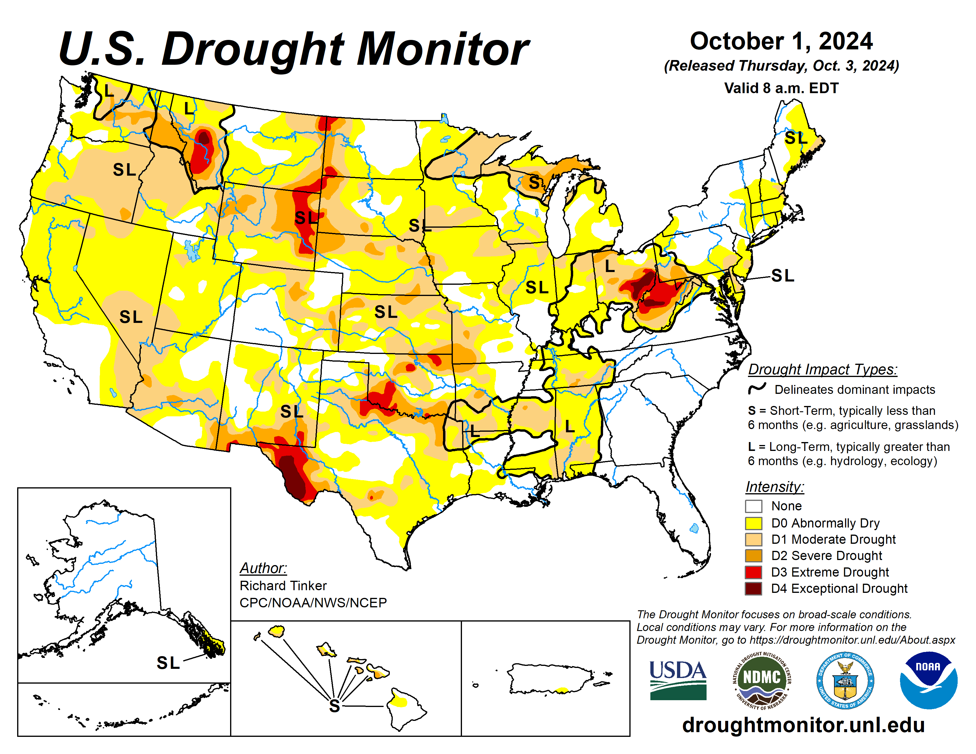
Grand Valley Power plans to use a federal grant to reduce wildfire-related dangers and boost system reliability in the Mesa Lakes area — The #GrandJunction Daily Sentinel

Grand Junction back in the day with the Grand Mesa in background

Click the link to read the article on The Grand Junction Daily Sentinel website (Dennis Webb). Here’s an excerpt:

October 4, 2024

Grand Valley Power plans to use a federal grant of nearly $2 million to bury 4.1 miles of existing power line serving the Mesa Lakes area to reduce wildfire-related dangers and boost system reliability. The local not-for-profit rural electric cooperative has received $1,947,204 from the U.S. Department of Energy through the Wildfire Assessment and Resilience for Networks project, or WARN. WARN funding comes from the department’s Grid Resilience and Innovation Partnerships program created by the 2021 Infrastructure Investment and Jobs Act, also known as the Bipartisan Infrastructure Bill. Grand Valley Power is a member of a consortium of 38 electric co-ops and other rural utilities selected to receive federal funding through WARN, it said in a news release. It will provide matching funds for the Mesa Lakes project. It expects the work to begin in late spring after the winter snow has melted.

Gila River Indian Community and Biden-Harris Administration Celebrate ‘First Power’ on Historic #Solar-Over-Canal Project, Marking a New Era in Renewable Energy and Water Conservation

Greg Stanton and Stephen Roe Lewis at the solar-on-canal project October 3, 2024. Photo credit: AZ-4 U.S. Representative Greg Stanton

Brad Udall receives David Getches Flowing Waters Award — #Colorado State University

Brad Udall is pictured at Boulder Reservoir, which helps deliver water from the Upper Colorado River to the Front Range. Photo: Vance Jacobs

Click the link to read the article on the Colorado State University website (Benjamin Randall):

September 2024

Brad Udall, a senior water and climate researcher at the Colorado Water Center at Colorado State University, has been honored with the prestigious 2024 David Getches Flowing Waters Award. The award recognizes Udall’s substantial contributions to water science and policy.  

Named after the renowned water law scholar David Getches, the award celebrates individuals who have made significant contributions to water policy and law. Getches, best known for his influential textbook Water Law in a Nutshell and his extensive work on the Colorado River, left a lasting legacy in the field.  

The award was presented to Udall by the Colorado Water Trust on Sept. 24 at a ceremony at the Denver Botanic Gardens. 

Kate Ryan, executive director of the Colorado Water Trust, said that presenting Udall with the award celebrates “the innovative and collaborative spirit exemplified by both David and Brad over their careers.” She continued, “By researching and communicating to broad audiences and key policymakers how climate change impacts hydrology in the Colorado River Basin, Brad has given water users including the Colorado Water Trust tools that are essential for protecting healthy flows in our rivers.” 

Udall said that receiving the David Getches Flowing Waters Award is a deeply meaningful honor and acknowledged the critical role Getches played in shaping modern water law and policy. 

“David was beloved by students, by faculty, by his family – by anybody who knew him,” Udall said. “Being a part of this legacy is a gift that is hard to come up with words for, frankly.” 

Early influences and career path

Udall’s journey into the world of water science and policy was shaped by a long-standing family tradition of public service. Coming from a family with strong political roots – his father, uncle, brother and grandfather all held significant public offices – Udall initially seemed destined to follow in their footsteps.  

“In some ways, my story starts with my political family, which deeply influenced who I am,” Udall said. “There’s a deep commitment to public service in my family. It extends back to my grandfather, who was a Supreme Court justice in Arizona.” 

However, he carved out his own path, pursuing a career in engineering and earning degrees from Stanford University and Colorado State University.  

Udall began his career as a consulting engineer but soon found his calling in the intersection of climate science and policy. His work with the University of Colorado’s Western Water Assessment, a National Oceanic and Atmospheric Administration-funded Regional Integrated Sciences Assessment program focused on integrating climate science with regional water management decisions, was instrumental in shaping his career.  

“The goal at the Western Water Assessment was to connect climate science with decision-makers in a meaningful way,” Udall explained. 

In 2014, Udall transitioned to the Colorado Water Center at CSU, where he continues to focus on making climate science accessible to both policymakers and the public. His mission to translate complex scientific concepts into actionable insights to guide better decision-making around water management in the U.S. West aligns with the Colorado Water Center’s mission. Since 1965, the center has served as a hub for water-related research, education and outreach to address complex water management issues in Colorado and the West. 

Bridging science communication and decision-making

Udall sees science communication as a critical tool in making research meaningful and applicable to real-world decisions. “It’s not enough for scientists to understand the data,” he emphasized. “We need to be able to explain it in a way that decision-makers and the public can understand, and then that understanding can fuel action.” 

Udall’s experience working with CU’s RISA program helped sharpen his communication skills. However, he acknowledges the challenges of conveying the intricacies of climate science, particularly when it comes to long-term projections and uncertainty.  

“Too many scientists want to caveat their findings to the point where they’re truly worthless for decision-making,” Udall said. “That’s where communication and journalism come in – many scientists don’t know that there’s a real art in being able to condense science down into stuff that decision-makers and the public can hear and understand.” 

In his role at the Colorado Water Center, Udall strives to communicate the urgency of water issues in the U.S. West while providing clear, actionable recommendations for policymakers. 

Looking ahead: Ongoing research and future challenges

While Udall is now working part time, his research and outreach efforts remain a top priority. He recently submitted a paper focused on groundwater issues in Arizona, highlighting the complexities of maintaining water balance in a state that is heavily dependent on groundwater resources.   

Udall is also leading a review paper on the future of the Colorado River, a waterway that is central to the region’s economy and ecosystem. The paper aims to provide a comprehensive summary of the current state of knowledge on the river and offer guidance on future management strategies.  

“Understanding the political and social context of water law is essential to producing better science,” Udall said. 

In a statement by the Colorado Water Trust, Udall is described as a humble person with a passion for the environment that “leads him to share what he knows about climate change and the coming impacts on rivers with audiences nationwide.”   

“Brad was one of the original voices speaking out on climate change impacts on water in the West long before many of us even had climate change in our vocabulary,” said Karen Schlatter, interim director of the Colorado Water Center. “His unwavering quest to educate and inform decision-makers and the public on water and climate change issues has shifted the dialogue from the abstract to reality, heightening awareness that climate change is now, it affects everyone and we must adapt to an altered water future. Brad is highly deserving of this award, and we are excited to celebrate his impactful career to date.”  

Reflections on a changing climate

Udall reflected on the broader challenges facing water management in the West. “Water is everything out here,” he said, “and climate change is altering the water cycle in ways we’re only beginning to understand.”  

He emphasized the need for adaptive management strategies that can respond to the unpredictable nature of climate change. “The only constant is change,” he remarked, “and we have to be ready for it.” 

Delayed farm bill punted until after election with Congress stuck on how to pay for it — Source #NewMexico

A farmer stores grain near Eldridge, Iowa, on Sept. 28, 2024. (Photo by Kathie Obradovich / Iowa Capital Dispatch)

Click the link to read the article on the Source New Mexico website (Allison Winter):

October 3, 2024

Sweeping legislation that would set food and farm policy for the next five years is in limbo, waiting for lawmakers to decide its fate after the election.

The latest deadline for the farm bill passed unceremoniously at midnight on Sept. 30, without a push from lawmakers to pass a new farm bill or an extension.

Congress will have to scramble in the lame-duck session set to begin Nov. 12 to come up with some agreement on the farm bill before benefits run out at the end of the year — which if allowed to happen eventually would have major consequences.

The law began 90 years ago with various payments to support farmers but now has an impact far beyond the farm, with programs to create wildlife habitat, address climate change and provide the nation’s largest federal nutrition program.

Ag coalition in disarray

The omnibus farm bill is more than a year behind schedule, as the bipartisan congressional coalition that has advanced farm bills for the last half century has been teetering on the edge of collapse.

Congress must approve a new federal farm bill every five years. The previous farm bill from 2018 expired a year ago. With no agreement in sight at the time, lawmakers extended the law to Sept. 30, 2024.

The delay creates further uncertainty for farmers, who are facing declining prices for many crops and rising costs for fertilizer and other inputs.

Lawmakers have some buffer before Americans feel the consequences of the expiration.

Most of the key programs have funding through the end of the calendar year, but once a new crop year comes into place in January, they would revert to “permanent law,” sending crop supports back to policy from the 1938 and 1949 farm bills.

Those policies are inconsistent with modern farming practices and international trade agreements and could cost the federal government billions, according to a recent analysis from the non-partisan Congressional Research Service.

‘Groundhog Day’ cited by Vilsack

The stalemate between Democrats and Republicans over the farm bill has centered on how to pay for it and whether to place limits on nutrition and climate programs.

Agriculture Secretary Tom Vilsack told reporters in a press call on Saturday that the process “feels like Groundhog Day” — because he keeps having the same conversations about it. Vilsack said Republicans “just don’t have the votes” on the floor for legislation passed in the House Agriculture Committee, which is why it has sat dormant in the House for four months.

“If they want to pass the farm bill they’ve got to get practical, and they either have to lower their expectations or raise resources. And if they’re going to raise resources, they have to do it in a way where they don’t lose votes, where they actually gain votes,” Vilsack, a former Iowa governor, said.

The Republican-led committee approved its farm bill proposal largely on party lines at the end of May, amidst complaints from Democrats that the process had not been as bipartisan as in years past.

Partisan division is not uncommon in today’s Congress but is notable on the farm bill, which historically brought together lawmakers from both sides of the aisle. Bipartisan support can be necessary for final passage because the size of the $1.5 trillion farm bill means it inevitably loses some votes from fiscal conservatives and others.

Shutdown threat

Lawmakers are on borrowed time with both the farm bill and the appropriations bills that fund the federal government.

The House and Senate both approved stopgap spending bills at the end of September to avoid a partial government shutdown. The short-term funding bill, sometimes referred to as a continuing resolution, or CR, will keep the federal government running through Dec. 20.

Some agriculture leaders had asked for the continuing resolution to not extend the farm bill, to help push the deadline for them to work on it when they return.

The day after they approved the CR and left the Capitol, 140 Republican House members sent a letter to congressional leadership asking to make the farm bill a priority in the waning weeks of 2024.

“Farmers and ranchers do not have the luxury of waiting until next Congress for the enactment of an effective farm bill,” the letter states, noting rising production costs and falling commodity prices that have put farmers in a tight spot.

House Democrats also say they want to pass a new farm bill this year.

House Minority Leader Hakeem Jeffries, a New York Democrat, listed the farm bill as one of his top three priorities for the lame duck. Also on his list were appropriations and the National Defense Authorization Act, which sets policy for the Pentagon.

“It will be important to see if we can find a path forward and reauthorize the farm bill in order to make sure that we can meet the needs of farmers, meet the needs from a nutritional standpoint of everyday Americans and also continue the progress we have been able to make in terms of combating climate crisis,” Jeffries said in remarks to reporters Sept. 25.

Nearly 300 members of the National Farmers Union visited lawmakers in September to ask for passage of a new five-year farm bill before the end of 2024.

“Family farmers and ranchers can’t wait – they need the certainty of a new farm bill this year,” National Farmers Union President Rob Larew said in a statement after the meetings. “With net farm income projected at historic lows, growing concentration in the agriculture sector, high input costs and interest rates, and more frequent and devastating natural disasters, Congress can’t miss this opportunity to pass a five-year farm bill.”

Disagreements over SNAP formula

The key dispute for Democrats this year is a funding calculation that would place limits on the “Thrifty Food Plan” formula that calculates benefits for the Supplemental Nutrition Assistance Program, SNAP.

It would keep SNAP payments at current levels but place a permanent freeze on the ability of future presidents to raise levels of food support. Democrats have characterized it as a sneaky cut to vital support for hungry Americans that makes the bill dead on arrival.

Republicans are using the limits as part of a funding calculation to offset other spending in the bill. The bill would raise price supports for some crops like cotton, peanuts and rice.

“They have to do one of two things,” Vilsack said of lawmakers. “They either have to recognize that they can’t afford all the things that they would like to be able to afford, if they want to stay within the resources that are in fact available … Or another alternative would be to find more money.”

Vilsack recommended finding other sources of funding outside the farm bill, like changes to the tax code.

“You close a loophole here or there in terms of the taxes or whatever, and you generate more revenue, and you have that revenue directly offset the increase in the farm bill. … That’s the correct way to do it. And that’s, frankly, the way Senator Stabenow is approaching the farm bill,” Vilsack said, referring to Senate Agriculture Committee Chairwoman Debbie Stabenow, D-Mich.

The Senate Agriculture Committee has had no public markup or formal introduction of a bill. But leaders say committee staff have been meeting weekly to discuss a path forward. Stabenow has not publicly disclosed the offsets for the money she says is available to be moved into the bill.

A powerful sprinkler capable of pumping more than 2,500 gallons of water per minute irrigates a farm field in the San Luis Valley June 6, 2019. Credit: Jerd Smith via Water Education Colorado

When it comes to probabilities, don’t trust your intuition. Use a decision support system instead! — NOAA

Click the link to read the article on the NOAA website (Brian Zimmerman):

October 3, 2024

This is a guest post by Brian Zimmerman, a climate scientist at Salient Predictions. Salient is a startup that utilizes advances in machine learning and artificial intelligence to develop and provide accurate, reliable forecasts on the subseasonal-to-seasonal timescales. Additionally, Brian serves as a decision support specialist, helping clients to navigate uncertainty in the most effective manner possible.

The nature of uncertainty

There are not too many things more frustrating in this world than unmet expectations. Your favorite basketball team has an estimated 79% chance of beating the upcoming opposition; yet, they lose, and you’re out $10 to your work betting pool. There was only a 15% chance of rain in the forecast one day before your friend’s wedding, and it starts raining precisely 10 minutes before the outdoor ceremony is supposed to start. Or perhaps you’re in the ENSO betting market.

Regular readers of the blog recognize that climate predictions are uncertain, including for the El Niño-Southern Oscillation (ENSO), which are expressed as probabilities (70% chance of El Niño coming) instead of forecasting a single black-and-white outcome (El Niño is coming). To make decisions in the face of uncertainty, we sometimes consciously, often automatically, use our best guess at how likely the various outcomes are and what our tolerance for risk in the given situation is. For all but a few of us (nerd alert!), this is done in a qualitative, intuitive fashion. 

The trouble is, humans aren’t very good at it. Most of us find it difficult to intuitively understand probabilities except 0, 50, and 100%. In order to make sense of an uncertain world, we often craft narratives that enable us to make decisions and move forward. Unfortunately, these narratives tend to be compromised by two traits: our penchant for overconfidence and our aversion to risk (see footnote #1). This generally leads us to sorely misestimate the likelihood of almost all events facing us as we move through our lives. An even more frustrating truth to face is that even if we correctly act on probabilistic information (know the true odds of a given event and make the best decision possible) the outcome may be opposite of what we favored.

So, what to do? This blog post aims to offer some tips and tricks that are likely to lead to greater fulfillment of all your most accurately estimated dreams! Let’s learn from a simple example. I’ll use a sports betting analogy to highlight the benefits of using calibrated probabilistic forecast models (like the CPC ENSO forecast!) for real-world decisions.

Betting on the Bulls: building a decision support system

Say you’re a Bulls fan, and there’s a betting pool at work. Given no information about them or their competition, you would assume that the odds that they win any given game is 50-50. In reality, not all teams are equally matched, so the true chances the Bulls will win a given game will vary. To maximize your odds of large profits over the season, you need a system for guiding how much to bet based on a range of probabilities. Good probabilistic decision making requires two key items (see footnote #2 for additional commentary): 

1) A clearly defined event with a yes-no outcome:

The Bulls will win their game tomorrow night.

2) A set of actions you’ll take at specific thresholds:

This table shows what you will gamble based on what you think the probability is of the Bulls winning against whatever team they are playing. The maximum you can put into the pool is $50. 

Your decision support system (DSS) for determining how much to bet based on your estimate of the percent chances of the Bulls beating their opponent. Credit: NOAA

If the odds are less than 50%, you don’t risk your money. The higher the odds above 50%, the more you bet. (Note: this table above is your decision support system or DSS.)

Now that we have our DSS, we can mock up how this system would work out in 3 situations: 

  1. a scenario where you know absolutely nothing about basketball, and don’t try to learn. You just bet randomly based on what you had for lunch that day. This is akin to using the Farmer’s Almanac to forecast ENSO. 
  2. a scenario where you are an experienced basketball enthusiast with a discerning eye. Your estimation of the true probabilities of the Bulls winning against any team they play is perfect. This would be equivalent to climate scientists having a model that perfectly predicts the chances of El Niño in a given season: for instance, when the model predicts there is a 70% chance of El Niño coming, El Niño actually happens 70% of the time.
  3. a scenario where you’re enthusiastic and like sports, and your estimation of the true probabilities of the Bulls winning against any team they play is good, but not perfect. This would be equivalent to climate scientists having a model that does not perfectly predict the chances of El Niño, but is pretty good! For instance, when the model predicts an 80% chance of El Niño coming, El Niño actually happens 60% of the time. 

How would you wind up in each of these situations? I worked up some code (see footnote #3) so we can explore the outcomes!

Outcomes!

Each experiment simulates 1,000 seasons of 82 games each. The tables below show excerpts from one season of the second (perfect estimates of the chances of winning) and third experiments (estimates of the odds of a Bull’s victory are good, but not perfect.)

(top) A simulated season in Experiment 2, where if you predict the Bulls have a 90 percent chance of winning a game against the 76ers, they do, in fact, win against them 90% of the time (line 2). (bottom) A season from Experiment 3, where your estimates of the chances are good, but not perfect. You estimate the Bulls have a 60% percent chance of beating the Wizards over time, but they only beat them 50 % of the time (Line 81). NOAA Climate.gov graphic, based on data from Brian Zimmerman.

Each bar chart shows the cumulative profit or loss from betting after 1,000 simulated basketball seasons. The amount of profit or loss is shown across the bottom of the chart, and the height of the bar indicates how many seasons had that total. When you bet randomly (top), you lose as often as you win, and your average profit is close to zero. When you bet following a decision support system that risks more when you think the Bulls’ odds of winning are higher, you make more than $500 on average even if you can’t predict their odds of winning perfectly (bottom). NOAA Climate.gov image, based on data from Brian Zimmerman.

The first thing to notice is that by simply utilizing a tailored decision support system (DSS), you can come out ahead over time even if all you know is the probability of your team winning a game. The figure above makes this obvious; randomly betting performs much worse overall! Yes, sometimes the Bulls lose when the chance of winning is high, but if you stick to the program (your DSS), you will end up ahead at the end of the season (in this simulation, see footnote #4).

Now, you might be saying to yourself, “Okay, sure, you can come out ahead if you know the probabilities perfectly, but no one actually knows the true odds of their team winning any game.” Not to fear! The bottom row of the graphic shows that, over the long haul, the consistent implementation of decisions derived from your DSS is almost always lucrative even when your forecasts are not perfectly reliable! It’s the DSS that is critical here.

Comparing the three experiments, we see something we’d expect—that using a decision support system based on perfect knowledge of the probabilities is the MOST lucrative. But we can also see something that is perhaps not intuitive: the figure below shows that over shorter periods of time, our imperfect estimates (or even random bets!) will sometimes put us further ahead than using perfect estimates of the odds.

Out of a thousand seasons, there will be some where random betting (top) or imperfect estimates of the chances of winning (middle) will make as much money as betting with perfect knowledge of the probabilities (bottom). Inevitable negative outcomes can be one of the hardest things for people to accept about forecasts that use probabilities. NOAA Climate.gov image, based on data provided by Brian Zimmerman.

That is because there is still some randomness in the actual outcomes of the game (see footnote #3 on “noise”). A 60% chance of victory means that you will lose your bets on occasion (60% does not equal 100%). It’s inevitable that there will be a single game, or even 5- or 10-game stretches (possibly even an entire season!), where you actually end up with higher profits using a DSS with imperfectly estimated probabilities or even just random bets.

This is shown in a different way in the line graph below. I cherry–picked a season that shows both Experiment 1(random guesses) and Experiment 3 (good, but not perfect estimates of the true probability) performing worse than Experiment 2 (perfect prediction of the probability)—but only for the 1st half of the season! In the end, if you follow your DSS, you end up much better off than randomly betting, even with imperfect estimation of the probabilities.

Game by game cumulative profits for season 796 from each of the three experiments. In this season of the experiments, the bettor scenario using a decision support system with true probabilities (blue) did worse than the other two strategies until the very end of the 82-game season! NOAA Climate.gov image, adapted from original by Brain Zimmerman.

Bringing it all together

This simple example shows how we can benefit from uncertain, probabilistic estimates of the chances a team will win a game. As frustrating as it may be, a single bad game or even one bad season doesn’t mean our strategy is flawed. Making decisions based on weather, climate, and ENSO forecasts is similar! In fact, any probabilistic forecast is similar.

In ENSO forecasting, a premium is put on using so-called “calibrated” forecast models, which are constructed using long hindcasts to create more reliable outlooks. In calibrating the model output, the goal is to make the forecast estimates closer to the true probabilities – which pushes us closer to the case outlined by Experiment #2This allows for the highest chance of the best outcomes over the long haul, but also by no means guarantees them.

Having a solid DSS means we also have considered our tolerance for risk and how to act upon the estimated forecast probabilities. This should help us avoid disappointment and stay true to the course when we don’t get an outcome we hoped for. In an inherently uncertain world, it’s the best we can do.

Lead editors: Rebecca Lindsey and Michelle L’Heureux. 

Footnotes

  1. Some additional reading: 
    Kahneman, Daniel. (2011). Thinking, Fast and Slow. London: Penguin Books. 
    Here’s a related Guardian article/interview with Kahneman where he states that if he could wave a magic wand and eliminate one thing, it would be “overconfidence.” 
    Kahneman and Tversky (1979). Prospect Theory: An Analysis of Decision under RiskEconometrica, 47 (2), 263-292. 
  2. Event Definition:
    An event can literally be anything! However, whatever you choose, it’s critical to be specific. It could be something like “the Bulls will win tomorrow’s game against the 76ers”, or “El Niño will develop between now and March 1st” – essentially, anything that can have a definitive outcome of either “yes it did happen” or “no it didn’t happen”. Thresholds of Actionability: Here is where it gets tricky. The goal for defining “thresholds of actionability” is to determine a set of actions you would take given the various probabilities of the defined event occurring. This can be complicated because it starts to incorporate all kinds of other concepts – and is highly prone to the influence of Narrative. It’s also highly personal because different people or organizations have different risk tolerances! Ideally, these thresholds of actionability would be defined and analyzed over some historical period in order to optimize the thresholds, but let’s leave that alone for now and just make up some that seem reasonable. We can go back to our sports example for some simple fun.
  3. I created a Betting Simulator to generate these experiments. You can run it yourself because I put the python code here: https://github.com/bgzimmerman/enso_blog. The results in this blog are generated from the output of 1000 synthetic seasons of betting in the pool. There are 82 games in a season – the true probability of the Bulls winning is created using a stochastic generator – your estimated probability (on which you cast a bet) is generated conditioned on the true probability. For simplicity, the profit on a win is equivalent to the bet placed. We explore two scenarios – one in which you are perfectly prescient (i.e. your estimated probability equals the true probability) and another in which we incorporate estimation error (a tunable parameter – it adds noise to the true probability to create your estimated probability). The addition of noise here is meant to emulate both the impact of having an imperfect model and how human Narrative can lead you astray from the true probabilities (i.e. “Oh they lost the last two games so they’re due for a win this time!”). Additional Notes: In this simple example, we’re not getting into issues of who pays out the bet, what are the house odds, etc. In real betting, a gambler allocates bets based on having an edge. Finally, reliable probabilities will give you a higher payout but only if the scoring is “proper” (see Brocker and Smith, 2007 and Gneiting et al., 2007).
  4.  Astute readers may note that in this simulation with the true probabilities there is not a single season of 82 games in Experiment 2 where you lose money. Even in Experiment 3 (estimated probabilities) you don’t often lose money over a full season. However, do not jump to the conclusion that as long as you know a little bit about the sport, betting for a full season will return some money! This outcome is a result of the assumptions in the Betting Simulator. The simulator could be easily adjusted so there are more opportunities to lose money. Download it and experiment yourself if interested!

Reclamation announces $9.2 million for Tribal water projects and emergency drought relief supported by the Investing in America agenda: Reclamation’s Native American Affairs Program is providing funding for technical assistance and drought mitigation for Tribes

Rio Grande. Photo credit: USBR

Click the link to read the article on the Reclamation website:

October 1, 2024

The Bureau of Reclamation today announced a $9.2 million investment supported by President Biden’s Investing in America agenda to support Tribal efforts to develop, manage and protect water and related resources, and mitigate drought impacts and the loss of Tribal trust resources.  The 25 projects selected through the Native American Affairs Technical Assistance Program, with funding from the Inflation Reduction Act and annual appropriations will benefit 18 federally recognized Tribes across 11 western states.

“Reclamation is committed to working with Tribal nations to prepare for and respond to the impacts of climate change across all western basins,” said Bureau of Reclamation Commissioner Camille Calimlim Touton. “The projects we’re funding today will improve water use efficiency and increase Tribal water supplies by upgrading infrastructure and programs and modernizing existing facilities. Reclamation is providing the resources necessary to ensure these sovereign nations have the modern water infrastructure crucial to the health and economic vitality of their communities.” 

Projects will assess and repair a water treatment plant and drinking water system, replace failing irrigation system equipment and lower pump elevations for river access, establish an on-site training and testing center for Tribal water system operators, and map a reservation water utility system to aid future improvement, expansion, and enhancements.

Examples of the projects selected for federal funding include: 

  • Hopi Tribe (Arizona) – $397,476 to establish an on-site training and testing center to provide specialized training, operator exams, and attainment of Tribal Utility Management certifications. This will alleviate the need for water system operators to travel for training. 
  • Chickasaw Nation (Oklahoma) – $400,000 to develop a project to protect and manage diminishing groundwater supplies, accomplish community water assessments, and devise a regional water management plan to safeguard critical community water supplies. The project is in partnership with the Southern Oklahoma Water Corporation, Arbuckle Master Conservancy District and the city of Ardmore, Oklahoma. 
  • Ute Mountain Ute (Colorado) – $278,434 to design the 1,000 acre-feet Red Arrow Regulating Reservoir to help stabilize irrigation water supply. The reservoir design will allow for banking water during wet years and capturing the operational spill at the end of the 39.9-mile Towaoc- Highline Canal. 
  • Fort Mojave Indian Tribe (California) – $400,000 to replace irrigation intake pumps and related equipment on the Tribe’s land along the Colorado River. The declining river level is impacting the Tribe’s ability to irrigate agricultural fields which members depend on for income. Declining water level due to extended drought conditions necessitates the revamping of pumping stations. Replacing the 1980s-era pumps and lowering their elevation will improve the supply of irrigation water.  
  • Ute Indian Tribe (Utah) – $400,000 to complete an assessment and repairs to its water system treatment plant to benefit the Tribes’ drinking water system. 

View a full list of projects on Bureau of Reclamation’s website

Section 80004 of the Inflation Reduction Act appropriates $12.5 million for Reclamation to provide near-term drought relief to Tribes that are impacted by the operation of a bureau water project. 

Reclamation’s Native American Affairs Program provides funding opportunities and technical assistance through cooperative working relationships and partnerships with Tribes. To learn more about these and other funding opportunities, visit www.usbr.gov/native

Native American Affairs Program

CPW introduces Trojan Male brook trout in a historic effort to protect native cutthroat trout in #Colorado

Aquatic Biologist Jon Ewert stocks Trojan Male brook trout into Bobtail Creek during a historic stocking event in the headwaters of the Colorado River basin. Photo credit: Colorado Parks & Wildlife

Click the link to read the release on the Colorado Parks & Wildlife website (Rachael Gonzales):

September 27, 2024

 On Tuesday, Sept. 17, in an effort to restore native cutthroat populations in the headwaters of the Williams Fork River, Colorado Parks and Wildlife stocked 480 Trojan male or YY brook trout into Bobtail and Steelman creeks.

“This is a pretty historic moment for Colorado and native cutthroat trout restoration across the state,” said CPW Aquatic Biologist Jon Ewert. “This is a combination of both the hard work and dedication of CPW biologists current and retired.” 

“This is yet another example of the groundbreaking work done by CPW biologists and researchers to preserve native species,” said George Schisler, CPW Aquatics Research Section Chief. “While Bobtail and Steelman creeks are the first to be stocked with YY brook trout, they will not be the last. This is just the first of many for Colorado.”

In 2010, an alarming number of non-native brook trout were discovered after completing a fish survey in the headwaters of the Williams Fork River. While it is unknown when brook trout invaded these creeks, it was evident the thriving brook trout had nearly decimated the native cutthroat population over time.

Cutthroat trout found within these two creeks are some of the highest-valued native cutthroat populations in the headwaters of the Colorado River basin. Considered a species of special concern in Colorado, this subspecies of trout is genetically pure and naturally reproducing. 

“In 2011 we found 123 cutthroat trout combined in both creeks. Today, after 13 years of hard work by dedicated biologists we are seeing a little more than 1,400 cutthroats in these creeks,” said Ewert. 

Trojan male brook trout are often called YY because they have two Y chromosomes, unlike wild males with an X and Y chromosome. These trout are stocked into wild brook trout populations and reproduce with the wild fish, producing only male offspring. Without a reproducing population (male and female fish), the brook trout will eventually die out, allowing for native cutthroat trout to be restored.

Colorado Parks and Wildlife will continue to stock both streams with YY brook trout over the next several years to sustain the number of Trojan males in the population, eliminating the production of female brook trout in the creeks. 

To learn more about Trojan male brook trout and cutthroat trout restoration project in the Upper Williams Fork drainage, read our latest Colorado Outdoors Online Magazine article. 

Cutthroat trout historic range via Western Trout

At last, juice from Taylor Park Dam: It took awhile to make this happen but it immediately is cheaper energy for Gunnison County Electric Assocation — Allen Best (@BigPivots)

Taylor Park Dam. Photo credit: Allen Best/Big Pivots

Click the link to read the article on the Big Pivots website (Allen Best):

September 25, 2024

When work was completed on Colorado’s Taylor Park Dam in 1937, at least some thought existed that it would eventually be modified to produce electricity.

In 2024, it is finally happening. The first commercial power production has or will very soon happen in the first days of autumn.

The new 500-kilowatt hydroelectric turbine and generator installed in the dam will operate at or near full capacity 24/7/365. It is projected to produce an average 3.8 million kilowatt-hours annually. That compares to a  2.5-megawatt fixed-til solar array.

The electricity will get used by Gunnison County Electric Association. Mike McBride, the manager, says the electricity delivered will immediately save the cooperative money compared to the power delivered by Tri-State Generation and Transmission.

Under its contract with Tri-State, Gunnison County Electric can generate up to 5% of its own power. This hydroelectric facility will get it to 3%. The association is working to gain the other 2% from local solar array developments, one near Crested Butte and the other near Gunnison.

Map of the Gunnison River drainage basin in Colorado, USA. Made using public domain USGS data. By Shannon1 – Own work, CC BY-SA 4.0, https://commons.wikimedia.org/w/index.php?curid=69257550

The Taylor River originates on the west side of Cottonwood Pass in the Sawatch Range. The road across the pass connects Buena Vista and Crested Butte and Gunnison. After being impounded by the dam that creates Taylor Park Reservoir, the river descends to meet the East River, which originates near Crested Butte. Together they become the Gunnison River.

Grand opening of the Gunnison Tunnel in Colorado 1909. Photo credit USBR.

The 206-foot-high earthen dam is owned by the U.S. Bureau of Reclamation but operated by the Uncompahgre Valley Water Users Association, which delivers water to the Montrose and Delta area via [the Gunnison Tunnel].

In 2020, that water association joined with the Gunnison County Electric Association to form a legal entity to finance the $3.6 million project.

George Sibley, a historian of all things water in the Gunnison Basin (and beyond), said the dam was originally intended for storing water for July through September.

In the 1970s that changed in a collaboration of the Bureau, the Uncompahgre water district, and Upper Gunnison Regional Water Conservation District. That collaboration allowed them to store water from Taylor in Blue Mesa Reservoir. This allowed water to be released continuously through the year.

“That year-round flow potential made it more possible to think of the Taylor Dam as a possible year-round power source,” he says.

But the coal-burning units at Craig were delivering plenty of cheap power. Only in the last couple of decades have the electrical cooperative started getting pressure from some members and “other cultural entities” to reduce emissions associated with their electricity, he says.

A study was commissioned in 2009 and wrapped up in March 2010. Beyond were more complications — but now success.

#Drought news October 3, 2024: #Wyoming and most of #Colorado saw temperatures average near or over 10 F above normal. As a result, dryness and drought in the region was unchanged or worsened

Click on a thumbnail graphic to view a gallery of drought data from the US Drought Monitor website.

Click the link to go to the US Drought Monitor website. Here’s an excerpt:

This Week’s Drought Summary

Hurricane Helene dropped heavy to excessive amounts of rain on a large area from the Ohio Valley, central Appalachians, and mid-Atlantic Piedmont southward to the eastern Gulf Coast region. The storm moved inland across the Florida Panhandle and northward into the South Atlantic States, then slowed down and drifted westward as it interacted with an upper-level low pressure system, becoming quasi-stationary as it slowly dissipated. The heaviest rains fell where precipitation was orographically enhanced on the east side of the Appalachians. Part of the central North Carolina mountains received 20 to almost 30 inches of rain, with totals topping 10 inches over the rest of the North Carolina mountains as well as the central Blue Ridge in Virginia, part of central and western South Carolina, some patches in central Georgia, and near the landfall site. More than 4 inches soaked a broad area from the middle and lower Ohio Valley southward through eastern Alabama and eastward through the central and southern Appalachians and Piedmont, including most of the Carolinas and Georgia. Widespread flooding resulted, with devastating floods impacting the wetter areas, along with prolonged power outages. Helene is the deadliest tropical system to affect the Nation since Hurricane Katrina in 2005, with a death total was approaching 200 as of this writing. At the same time, the intense rains dramatically improved or ended the various degrees of dryness and drought that had been affecting many of the areas impacted by Helene, especially from the Appalachians westward through the Ohio and Tennessee Valleys and southward to the central Gulf Coast, in addition to much of South Carolina and northern Georgia. Outside the broad area impacted by Helene, subnormal precipitation prevailed across most of the contiguous states. Precipitation was almost non-existent over a large area from the western Great Lakes and most of the Mississippi Valley westward to the Pacific Coast, with only scattered sites in the northern Intermountain West and areas from the northern Cascades to the Pacific Coast receiving over one-tenth of an inch. Above-normal temperatures accompanied the low precipitation totals, resulting in dryness and drought persisting or intensifying across this area covering a majority of the contiguous states. Farther east, the Northeast, mid-Atlantic region, and eastern Great Lakes recorded generally 0.5 to 2.0 inches of rain, with a little more reported in parts of western Michigan, southern and western Pennsylvania, and the higher elevations from upstate New York eastward across Vermont, New Hampshire, and western Maine…

High Plains

It was very warm and almost bone dry throughout the region, with only a few highly isolated spots of measurable rainfall. Unusually high temperatures worsened the situation, with weekly mean anomalies ranging from +1 to +2 deg. F in eastern Kansas to +15 to +18 deg. F in most of the Dakotas. Wyoming and most of Colorado saw temperatures average near or over 10 deg. F above normal. As a result, dryness and drought in the region was unchanged or worsened. Moderate to severe drought expanded in coverage across the central Great Plains and northern High Plains, with increased areas of extreme drought D3) noted in eastern Wyoming, plus a few spots in the western Dakotas. Over the past 30 days, only a few tenths of an inch of rain at most has fallen on much of Wyoming and Nebraska, northern Kansas, and the southeastern Dakotas…

Colorado Drought Monitor one week change map ending April 1, 2024.

West

Some of the higher elevations in Washington recorded 1.0 to locally 2.5 inches of rain while a few tenths of an inch were measured in other parts of the Northwest from the Cascades to the Pacific Coast, and in portions of northern Idaho and northwestern Montana. However, most of the West was very warm and free from any measurable precipitation. A few areas in Utah saw conditions noticeably deteriorate this past week, but no other degradations took place. Some D0 and D1 areas were actually scaled back in central and northwestern Montana despite the warm and dry week due to a few rounds of heavy precipitation in late August and September, which has continued to have a positive impact on soil moisture, vegetative health, and 1- to 4-month precipitation anomalies. Elsewhere, conditions are unchanged from last week. Low relative humidity, high temperatures, and gusty winds continue to produce periods of extreme fire danger, and supplemental feeding and watering of livestock has been common in eastern Montana. With the Southwest monsoon season ending and the wet season in the West not yet underway, drought tends to progress slowly in the region this time of year…

South

Intense rains spawned by Helene dropped 2 to locally 6 inches of rain on Tennessee and northeastern Arkansas, but lesser amounts fell elsewhere. A few tenths of an inch of rain (with isolated higher amounts) fell on parts of eastern Texas and Oklahoma and scattered portions of Louisiana, Mississippi, and the remainder of Arkansas. Other locations recorded little or no rain. Predictably, the heavy rains across Tennessee led to broad-scale reductions in the areal coverage dryness and drought, leaving only south-central parts of the state in drought (D1 and isolated spots of D2). Improvements were also indicated in northern Mississippi and eastern Arkansas, where a re-assessment of conditions demonstrated that early September rainfall from Hurricane Francine was more beneficial than initially thought. Meanwhile, D0 was expanded across southern Louisiana, and areas of deterioration were identified in Texas and Oklahoma, including an expansion of exceptional drought (D4) in the Texas Big Bend, and increased coverage of severe to extreme drought (D2 to D3) in portions of Oklahoma. Rainfall during the past 60 days was less than half of normal in portions of northeastern Oklahoma, the Red River Valley, eastern Texas, and the Texas Big Bend. According to the U.S. Department of Agriculture (USDA), half of the Texas cotton crop was in poor or very poor condition, along with 31 percent of Texas corn and 24 percent of Oklahoma cotton…

Looking Ahead

During the next five days (October 3 – 7), warm and dry weather will dominate the contiguous United States. Very little if any precipitation is expected across a vast majority of the Nation. The Florida Peninsula the immediate rim of the Gulf Coast are significant exceptions, where abundant tropical moisture is expected to feed heavy rainfall. There is some potential for tropical cyclone development over the Gulf later in the period. Over an inch is forecast across the Florida Peninsula and along parts of the immediate Gulf Coast from the Florida Panhandle through coastal southern Texas. Generally 1.5 to 3.0 inches are expected in a swath across the central Florida Peninsula and near the central Gulf Coast, with heavy amounts of 3 to 5 inches forecast on the Florida West Coast from the Tampa area southward through Ft. Myers, and across the Louisiana Bayou. Moderate amounts (0.5 to 1.5 inches) are forecast from the Cascades of Washington and northern Oregon westward to the Pacific Coast, and over parts of northern Idaho and adjacent Montana. Meanwhile, several tenths of an inch are expected across most of the Great Lakes region and the Northeast. Several tenths of an inch are also expected over most of Hawaii, with the largest totals forecast in central Lanai, eastern Maui, and part of the western Big Island. Between 2 and 3 inches are expected to fall on southeasternmost Alaska, where normals are relatively high. Near normal temperatures are expected in most areas east of the Mississippi River while well above-normal temperatures should prevail farther west. Daily maximum temperatures 10 – 15 deg. F above normal are anticipated from the central and northern Plains through most of the Rockies and Intermountain West to near the California Coast. Temperatures are expected to average closer to normal across Hawaii and southeastern Alaska.

The Climate Prediction Center’s 6-10 day outlook (valid October 8 – 12) continues to favor warmer and drier than normal weather for most of the Nation. Above-normal rainfall is expected to continue across the Florida Peninsula, possibly spreading into southern Georgia. Meanwhile, marginally-enhanced chances for wetter than normal weather cover much of Maine, portions of the Far West from the Cascades westward, and west-central California. A much larger area with increased chances for drier-than normal weather stretch across the northern Rockies and from the High Plains eastward through the southern and middle Atlantic Coast. The best odds for subnormal rainfall extend from the Great Lakes southward through the lower Ohio and middle Mississippi Valleys. Surplus precipitation is expected in southeasternmost Alaska while totals over Hawaii are expected to be near normal. Meanwhile, warmer than normal weather is expected from the Great Lakes and the Mississippi Valley westward to the Pacific Coast, with odds for unusual warmth exceeding 80 percent over northern and central sections of the Rockies and Plains. Warmer than normal weather is also favored over the Florida Peninsula. In contrast, there are enhanced chances for subnormal temperatures along the Eastern Seaboard from Georgia through Maine, over most of the Appalachians, across the middle and upper Ohio Valley, and in the Tennessee Valley and adjacent areas. Outside the contiguous U.S., near normal temperatures are forecast for southeast Alaska, with nominally elevated chances for warmer than normal conditions across most of Hawaii.

US Drought Monitor one week change map ending April 1, 2024.

Romancing the River: The Headwaters Challenge 2 — George Sibley (SibleysRivers.com) #ColoradoRiver #COriver #aridification

East River. Photo credit: Sibley’s Rivers

Click the link to read the article on the Sibley’s Rivers website (George Sibley):

October 2, 2024

In the last two posts here (one of which you got twice, my apology), I’ve been trying to ‘revision’ the Colorado River as the classic desert river that it is. All rivers are composed of runoff – water from precipitation that did not soak into the ground, collecting in streams that ‘run off’ to the next lower watershed. Humid-region rivers receive new water from unused precipitation all the way along their course to the sea, but a river in the arid lands obtains nearly all of its water as runoff from a highland area high enough to force water vapor to condense into precipitation. The resulting runoff from that precipitation then flows down into the arid lands where it receives very little additional moisture and thus starts to diminish through natural processes on its way to the sea – evaporation under the desert sun, riparian vegetation use, absorption into low desert water tables. When the deserts are large enough, and the rivers’ highland water supplies erratic enough, some desert rivers disappear entirely, seasonally if not year round, before they get to the ocean.

As a desert river, the Colorado River divides naturally into a water-producing region in mountains mostly above ~8,000 feet elevation (only about 15 percent of the basin area, mostly in the Southern Rockies), and a much larger water-consuming region of arid lands, both orographic ‘rain-shadow’ deserts and hot subtropical deserts. Because the majority of its surface water comes from snowmelt, the pre-20th-century Colorado River regularly sent an early summer flood of water down into the Gulf of California, but later in the water year, snowpack gone, it probably did not always make it all the way through its jungly delta to the sea. Today, with 35-40 million water users in the Colorado River’s water-consuming region as well as those natural processes, the highly controlled river only makes it (almost) to the ocean in an occasional planned release.

In the last post we began exploring the river’s Headwaters – its water-producing region. To refresh your memory, here’s is the set of maps that, in effect, show the river’s water producing region – the blue areas on the map on the left, which show the average quantities of water (snow water equivalent) held in the peak snowpack, usually late March or early April:

It’s important to note that the water-producing and water-consuming regions of the Colorado River region are not congruent with the Colorado River Compact’s Upper and Lower Basins (above and below the line dividing the area outlined in black). The water-consuming region consists of nearly all of the Lower Basin and most of the Upper Basin – and includes all the trans-basin consumptions via long canals and tunnels).

The river’s actual water-producing region (blue areas inside the black line) is barely a fourth of the Upper Basin and some Lower Basin uplands that produce water for the Gila, Virgin and Little Colorado Rivers. That region is our focus today.

I will begin by suggesting that the 35-40 million of us in the water-consuming region of the Colorado River Basin (plus extensions) should have an investment of at least interest and concern, if not (yet) a fiscal investment, in our river’s water-producing region.

Whoa! What’s that? In addition to doing everything we can to conserve and extend the water we use in our deserts – we arid-land river users have to be involved – maybe eventually financially – with the river’s water-producing Headwaters as well? Why shouldn’t the people that live there take care of that?

One obvious reason is the fact that comparatively very few people live in the Headwaters above 8,000 feet. Nearly all of it is public land, National Forests managed for the ‘multiple uses’ of all the people. But the larger reason for water users in the consumption region to be investing at least attention and political interest in the Headwaters is the fact that we – the 40 million of us consumptive users – are the people with the greatest direct interest in what happens in the mountains. We depend on those Headwaters for 90 percent of our water supply, and our concern ought to be apparent: we want as much water as possible making its way out of water-producing region into the region of consumption, especially as our river’s flow diminishes by the decade.

Because the border between the water-producing region and the water-consuming region is a natural rather than political boundary, it is not really a line at all (like the 8,000-foot contour),  but more of a blurry edge zone, an ecotone with varying levels of both water production and consumption in it. In Gunnison where I live, for example, at 7,700 feet elevation, we receive on average just a little over 10 inches of precipitation annually – the upper edge of an arid region that continues down through the Colorado River Basin to the river’s end in the subtropical deserts. But 30 miles up the valley from Gunnison, the town of Crested Butte at 9,000 feet gets around 24 inches a year on average, a water-consuming community up in the water-producing region – and all of the valley floodplains between the two towns that are not yet subdivisions are in irrigated hay fields. This is the ecotone, the edge zone in which the net balance between water production and water consumption gradually shifts, over a mere 30 miles, from mostly production to mostly consumption, as precipitation diminishes to desert levels.

Mining and resort towns above 8,000 feet are, however, pretty minor consumers of precipitation-produced water, compared to consumption by natural forces at work in the area. In the last post we explored some of those natural forces in addressing a mystery posed by the Western Water Assessment’s report on the ‘State of Colorado River Science’: ~170 million acre-feet of precipitation fall on the Colorado River Basin every year on average, but only ~10 percent of that becomes the river’s water supply. What happens to the other 90 percent?

The perpetrators of this loss turn out to be the sun that originally ‘distills’ the freshwater from the salty ocean and the prevailing winds that carry it across a thousand miles of mountain and desert to condense it into a snowpack in the high Rockies. The sun and wind give, and the sun and wind take away – starting immediately after the giving.

The precipitation forced from water vapor in the air by our mountains is barely on the ground before the sun and wind are trying to return it again to vapor. Throughout the main water accumulation period, the winter, sublimation – the conversion of ‘solid water’ directly to water vapor by sun and wind – is eating away at the exposed snowpack every sunny or windy day, even at temperatures well below freezing.

Then once the mountains warm up enough for the snow to melt, the sun and wind evaporate what they can of the water that runs off on the surface, especially where it is pooled up or spread out on the streams’ floodplains. The snowmelt water that sinks into the ground goes into the root zone of all the vegetation on the land – grasses, shrubs, brush and trees – where it is sucked up by the thirsty plants, with most of that being transpired back into the atmosphere as water vapor to cool and humidify the working environment of the plants.

Sublimation, evaporation, transpiration – exactly how much water each of these activities of sun and wind convert back to water vapor is difficult to measure, but the end result is that less than a quarter of the water that falls on the mountains stays in the liquid state as runoff creating the streams that become the river flowing into the desert regions where 35-40 million of us depend on it, and less than five percent of what falls on the water-consuming desert regions augments the river there. The sun and wind give, and take away.

The question arises: are there not some ways in which we might retain or recover some of that lost water? That question may begin to sound like another charge for planet engineering – crystals in the stratosphere to reflect heat away from the planet, et cetera. I am not so ambitious as that.

But we know that the Colorado River has lost as much as 20 percent of its water over the past several decades from a combination of climate warming and drought, and even if the drought ends, we will lose morein the decades to come from the warming of the climate already made inevitable from our ongoing reluctance to do much about it. Scientists estimate that for every Fahrenheit degree of average temperature increase, we will lose 5-7 percent of our surface waters from heat- sublimation, evaporation and transpiration. So is there anything we can do – affordably, and undestructively – down here where the water is, to mitigate that loss, if only partially?

Obviously, the sun and wind rule unchallenged in the highest Headwaters, the treeless alpine tundra. But as one moves down into the treeline – another ecotone with the subalpine spruce-fir forest gradually becoming the dominant ecology over the miniature plants and windbeaten krumholz trees of the tundra. The forest shades the snow that makes it down to the snowpack from the sun, and shelters it from the wind. But the forest also catches a lot of snow on its branches, and that snow is prey to the sublimating sun and wind.

The shading trees also slow how fast the ground snowpack melts; in the deep forest, patches of dirty snow can last into the early fall. A slower melt means a higher ratio of water sinking into the ground over water running off to the 35-40 million of us waiting for it downriver. But the trees of the forest exact a high price for their protective efforts; the water sinking in is sipped up by the roots of all the forest vegetation, and the trees are heavy drinkers, transpiring most of what they drink.

Nearly all of the forests that run a wide belt through the Colorado River Headwaters region – the subalpine spruce-fir forests and the montane pine forests – are, as mentioned earlier, public lands designated National Forests, set aside to protect them.from the Early Anthropocene Age of Plunder. A huge number of them were designated by President Theodore Roosevelt, considered the Father of American Conservation, with forester Gifford Pinchot riding shotgun. Pinchot probably had a hand in crafting the 1897 Organic Act that created the National Forest concept out of scattered federal ‘Forest Reserves’ set aside under earlier legislation, but with no management or legally impowered managers explicit.

The Organic Act was fairly explicit in defining the purpose for creating National Forests:

Recognizing that just setting the land aside with no process for ‘improving and protecting the forest’ was, in the still pretty wild West, equivalent to hanging a sign on the reserve saying ‘Get it while you can, boys, because someday you might be banned,’ the Organic Act also provided for ‘such service as will insure the objects of such reservations’ – which ‘service’ became, under Roosevelt and Pinchot, the U.S. Forest Service.

Note that there are two fairly specific charges in the quotation from the Organic Act: ‘securing favorable conditions of water flows,’ and ‘furnishing a continuous supply of timber.’ Given the circumstances of a nation continually growing and building, with the American dream being a home of one’s own, it goes without saying which of those two tasks the evolving Forest Service has been mandated to prioritize. For much of their history, the Forest Service has been expected to fund themselves with a surplus to the U.S. Treasury through timber sales – always harvesting of course in ways that ‘improve and protect the forest’ (possible, but increasingly improbable when demand grows extreme and supply trudges along at nature’s unhurriable rate).

The charge to secure favorable conditions of water flows, however, has been given much less attention. Pinchot said that ‘the relationship between the forests and the rivers is like the relationship between fathers and sons: no forests, no rivers.’ That is clearly not the case; the forests are not the creators of rivers, they are instead just the first major user of the rivers’ waters; they protect the snowpack and slow the melt for their own needs. Pinchot was right in perceiving a relationship between forests and rivers, but had it backward: ‘No water, no forests’ is more accurate.

One might think, then, that in the Headwaters of the most stressed and overused river in the West, if not the world, the managers of the Headwaters forests might be expending serious effort to make sure that they are securing the most favorable flows possible from their forests.

What I am having trouble discerning is whether the Forest Service is paying any attention at all to any responsibility for a water supply that 35-40 million people are depending on. In my ‘home forest,’ for example, the Gunnison National Forest – now bundled together for management efficiency with two other National Forests as the ‘Grand Mesa Uncompahgre Gunnison National Forests (GMUG): the first draft of a GMUG Forest Management Plan being drafted over the past 2-3 years did not even mention the Colorado River Basin by name as a larger system they are part of, and hugely important to. Response letters from ecofreaks like me (I assume others also wrote them about this) got a paragraph about that larger picture into the final draft – but nowhere in the plan itself did I find explicit discussion of the larger mission that implied and of specific management strategies for making sure that the plan was fulfilling that organic charge of securing favorable – one might say ‘optimal’ – conditions of water flows.

Well – that launches into an exploration of National Forest management policies and activities that I am still trying to muddle through, but that can wait till next month. I’ve gone on long enough here for now, in this effort to peer over the edge of the box we’re all supposed to be trying to think outside of – the ‘Compact Box’ that all the water buffalo are still stalemated over, as we all try to envision river management after the expiration of the Interim Guidelines from 2007. Stay tuned.

National forests and grasslands

New SNOTEL to help #Aspen’s water planning: Castle Peak site collects weather, snowpack data — Heather Sackett (@AspenJournalism )

This new SNOTEL site near the headwaters of Castle Creek measures snowpack, temperature, soil moisture and other weather data. The city of Aspen will use the data to better understand its water supply. Credit: Heather Sackett/Aspen Journalism

Click the link to read the article on the Aspen Journalism website (Heather Sackett):

September 26, 2024

Water managers at the city of Aspen have a new tool to help them better understand and plan for the city’s water supply.

Last week, after four years of planning and permitting, crews from the National Resources Conservation Service installed a new snow telemetry (SNOTEL) site in the headwaters of Castle Creek. Named Castle Peak, the new SNOTEL site is one of the highest in the state at 11,500 feet.

The SNOTEL network is a collection of over 900 automated remote sensing sites in high-elevation, mountainous watersheds across the West. The stations collect data about snowpack depth and water content, air temperature, wind, solar radiation, humidity, precipitation and soil moisture.

This publicly available data provides a real-time snapshot of conditions in Colorado’s high country. It can help avalanche forecast centers know how much new snow is in the backcountry after a storm; soil moisture data can help wildland firefighters know when forests are dangerously dry.

Perhaps most importantly, SNOTEL data helps scientists understand climate change impacts to water supply and predict how much water will be available come spring.

“In the western United States, about 80% of the annual water used in many basins comes from mountain snow,” said Brian Domonkos, NRCS Colorado snow survey supervisor. “That means it’s a resource we can monitor and get an idea of how much water we have in the snowpack and anticipate how much will be melting in the spring for use throughout the summer.”

The city of Aspen staff requested the site just below treeline off of Pearl Pass Road because the city gets the majority of its water from Castle Creek. NRCS agreed it would be a good spot to enhance their network of SNOTEL sites. Aspen paid the $45,000 cost of setting up the site, while NRCS will be responsible for maintaining it going forward. 

“Most folks are pretty psyched that we have another piece of data and something that will be more representative of the basin than what we’ve had in the past,” said Steve Hunter, utilities resource manager with the city of Aspen. 

Castle Creek flows downstream from the bridge on Midnight Mine Road, just above the city of Aspen’s diversion. Aspen is hoping to get a stream gauge on this stretch of river to better understand its water supply. Credit: Heather Sackett/Aspen Journalism

Site fills a data gap

Aspen water managers previously have used SNOTEL sites on Independence Pass, Schofield Pass, North Lost Trail, Upper Taylor in the Gunnison River basin and sites in the Fryingpan River basin to estimate how much water was in the Castle Creek drainage.

“There was really this big hole, a missing gap in this area,” Hunter said. 

In many cases, SNOTEL data can help officials manage their reservoirs, releasing more water to make room for a big spring runoff or holding more back in years with a sparse snowpack. Aspen does not have a big storage bucket; the Leonard Thomas Reservoir it uses to store municipal water only holds about 10 acre-feet. Hunter said Aspen will use the SNOTEL data to make decisions about water conservation and when to enact outdoor watering restrictions.

“It gives us a way to quickly adapt, depending on what we’re seeing up there as far as snowpack,” he said. “I think that’s going to be super helpful.”

Aspen received several letters of support for the project when it was applying for a grant from the U.S. Bureau of Reclamation in 2020, including from Pitkin County, Colorado Water Conservation Board, Roaring Fork Conservancy and Aspen Global Change Institute. While the grant wasn’t funded, it demonstrated strong support for the new SNOTEL site.

“Since all data from these proposed stations will be public, these monitoring sites would benefit both the city of Aspen and other mountain towns and municipalities seeking to better understand potential climate change impacts on water supplies,” reads the letter from AGCI.

The Castle Peak SNOTEL is just one piece of Aspen’s effort to better understand its water supply availability. It’s 2020 Municipal Drought Mitigation and Response Plan says the city would benefit from a stream gauge on Castle Creek above its diversion point to improve monitoring and make drought declaration decisions. The city is still working on the Castle Creek stream gauge.

Along with other governments across the state, Aspen has also funded Airborne Snow Observatories, a company that measures snowpack from the air using LiDAR, a laser technology that can sense snowpack depth across a wide area. Aspen contributed $50,000 to ASO flights in the Roaring Fork watershed this year. 

Real-time data from the new SNOTEL site can be found on the NRCS website. The site does not yet have “percent of normal” values since this is its first year of operation.

This story ran in the Sept. 27 edition of The Aspen Times and the Vail Daily.

Rubber Soul, the path to elevation 1,040, and the game of chicken on the #ColoradoRiver — John Fleck (InkStain.net) #COriver #aridification

Cracked mud – memories of Lake Mead’s low stand. Art and photo by L. Heineman.

Click the link to read the article on the InkStain website (John Fleck):

September 29, 2024

Two years ago, when the level of Lake Mead was hovering near elevation 1,040, my artist wife Lissa Heineman and I drove out over UNM’s fall break to see it for ourselves.

Out beyond the old Boulder Harbor, we walked a half mile across mud flats to get to the water. I could look out across the water to see the elbow of the old Southern Nevada Water Authority intake, above the water line. I was gut-punched by the visceral reality.

Lake Mead in the 1,040s, October 2022. Photo credit: John Fleck/InkStain

On the walk back to the car, Lissa carefully picked up some pieces of cracked mud. Her art has always been wrapped up in the conceptual properties of her materials. So she carefully packed up the cracked mud in a box and took it home. It’s been sitting in her studio ever since, and last month she tried firing some of it atop some small ceramic plates in her kiln.

It worked, and she gave me the results to give to my Lower Basin/Lake Mead friends. The texture of the mud, with ripples across the sandy and muddy reservoir bottom, captures a moment in history I hope we never repeat.

So last week, with the Colorado River brain trust in Santa Fe for the Water Education Foundation’s always-fascinating Colorado River symposium, I drove up to see folks and stuck a couple of Lissa’s pieces in my backpack.

I shared them with a message: That was scary. Let’s not go back there again. Please don’t fuck this up.

I’ve got a lot going on – revisions to the new book, teaching my fall semester graduate-level water resources class, nervously eyeing the levels in Lake Powell and Lake Mead, and the gridlock in Colorado River negotiations. So when my brain suggested listening to Rubber Soul Friday night, I was resistant. But we’ve been together for a long time, and I trust my brain’s judgment. So Rubber Soul it was.

What a great album.

This post is lengthy and rambly, so for those who are annoyed by my discursive side trips and just here for the Colorado River stuff, I’ve added anchors to the key material:

Eugene Clyde LaRue measuring the flow in Nankoweap Creek, 1923. Photo credit: USGS

Rubber Soul and my fascination with innovation

When Eric Kuhn and I set out to write Science Be Dammed, the project arose in part out of a mutual fascination with E.C. LaRue, the early 20th century hydrologist who first tried to map out the supply of water, and possible uses of it, across the entire Colorado River Basin. The thing that first drew me to LaRue, long before I knew Eric, was the fundamental innovation of what LaRue and the others working at the time on similar projects were doing. No one had ever tried to envision managing a continental-sized river at the full basin scale.

Rubber Soul

In an entirely different context and framework, it’s a theme Bob Berrens and I take up in our new book Ribbons of Green, about the making of a city.

The first time I remember thinking hard about this was when Lissa, my sister Lisa, and I saw the Hermitage exhibition at the Los Angeles County Museum of Art in 1986. It was a magnificent sweep of early modern painting that had been collected by rich Russians before the revolution. I remember rounding a corner and being gobsmacked by a big Picasso canvas, Three Women, one of the first few cubist paintings that he and George Braque had been making in Paris in 1907-08. Lissa, who understood the history, took me back through the rest of the exhibit to see the roots – the impressionists breaking one way, Matisse another, and Cezanne sweeping them all away with the beginnings of the deconstruction of the picture plane that led to Braque and Picasso.

My own father had been deeply influence by the reverberations of that work, and I had always seen it in Dad’s work, but it wasn’t until Lissa held my hand and walked me through the history that I began thinking about pathways. How does this happen? Once I saw, read, and learned about it once, I became hungry for examples. My intellectual life is now littered with them. I have long since soured on Picasso himself (what an asshole!), but the genre of intellectual journey continues to fascinate.

The most interesting books I’ve read in recent years all document this – Patti Smith’s Just Kids, about the birth of punk and her invention of Patti Smith; Amartya Sen’s memoir Home in the World; Henry Threadgill’s Easily Slip Into Another World (I still can’t grasp the music, but his story of innovation is a joy); Stanley Crouch’s biography of early Charlie Parker, Kansas City Lightning. In each case (three memoirs, one not), the innovation is rooted in a deep understanding of the past and foundations, and then the ability to see, out of that, something entirely new. And all four books are ripping good reads.

I love playing this game with the Beatles, because thanks to streaming services it is possible to dive in and listen to them learning on the fly, to watch the way the bar band Beatles learned how audiences responded to the old things and began envisioning something new.

This is metaphor.

The path to elevation 1,040

As we near the Sept. 30 end of the water year, Lake Mead is at elevation 1,064 feet above sea level, twenty feet above where it was when Lissa picked up the cracked mud two years ago.

In 2021-22, it took one year to drop from the 1,060s to the 1,040s. Could this happen again?

The short answer is probably not in a single year, because of a couple of things that have changed since then. But in two years? Yup. Lissa and I could have a chance to collect more 1,040s cracked mud.

The first thing that has changed since 2022 is the release from Lake Powell. In 2022 the Basin was in the midst of its hair-on-fire crisis management because of fears of Powell dropping dangerously low, so the Powell release that year was just 7 million acre feet. This year, it’s 7.48 million acre feet. So more water coming into Mead.

Things are also better on the outflow side. In 2022, the three Lower Basin States used 6.66 million acre feet. This year, the latest forecast number is 6.09 million acre feet.

Between the higher inflows and lower use, the latest midpoint forecast has Mead ending next year at 1,059 feet above sea level, with Reclamation’s most pessimistic model runs (the “minimum probable”) at ~1,054. But the min probable clearly shows risk out at the edge of what our headlights can illuminate right now, of dropping back into the 1,040s again by the summer of 2026.

The game of chicken on the Colorado River

The “game of chicken” is a game theory classic. It involves a conflict which, in the classic storytelling version, involves two drivers headed toward one another on a collision course. We’ll call them “U” and “L”. Each has the option to swerve or stay on course. The best outcome for each driver is for the other to swerve and lose face (water), while the driver who stays the course demonstrates dominance (keeps its water). But if neither swerves, we end up with a catastrophic collision. In the game theory matrix, it looks like this, with the payoffs for each:

Driver U SwervesDriver U Stays
Driver L Swerves(0,0)(-1,1)
Driver L Stays(1,-1)(-10,-10)

I’m obviously talking about the Upper Basin and the Lower Basin here, which are at impasse over the Lower Basin’s proposal to cut deeply up to a point (1.5-ish million acre feet total) and, if any deeper cuts are needed, to share them among the two basins.

The Upper Basin’s counter is basically “no.” If deeper cuts are needed, the Lower Basin should make them.

The payoff matrix, though, is a lot more complicated than my toy example above. First, both sides can gamble on good hydrology, which could avert the crash. So even if the impasse remains, the collision is not a sure thing. (In this regard, it’ll be interesting to see how the players’ strategies shift if we have a really bad winter.)

The second is the nature of the collision itself. No one knows quite what it will look like.

In the classic chicken game, both drivers know about the crash that happens if neither swerves. But part of the risk calculation we all have to live with right now is the uncertainty about what happens if the Upper and Lower Basin states can’t come to an agreement. We also have a situation where the nature of the game is changing over time.

Walking down a Santa Fe sidewalk Wednesday evening after dinner, one of my Colorado River friends observed that both sides seem to think that, if the collision comes, they have a winning legal argument.

If you think that, your understanding of what happens in the bottom right quadrant of the matrix, the crash scenario, is very different.

The Upper Basin seems to have convinced itself, at least based on public pronouncements, that it has a winning legal argument in terms of its obligation, or lack thereof, to send water downstream past Lee Ferry. This seems dangerous to me given my understanding of the history and the law, but it doesn’t matter what I think. The Upper Basin seems happy to keep hammering down the road.

Once deliveries past Lee Ferry drop below one of the “tripwire” triggers (82.5maf / ten years or 75/10), the Lower Basin states have nothing to lose by suing. And when that happens, my community’s water supply is at risk if my basin’s lawyers aren’t right.

Crash!

A few years back Kaveh Madhani and Bora Ristic wrote a paper working out the details of a game theory example that seems to fit what we’re currently seeing in the Lower Basin’s proposal to “own” the 1.5 million acre feet of structure deficit, and to try to negotiate some sort of sharing arrangement if the cuts need to go deeper. This would appear to be what Ristic and Madhani describe as “strategic loss.”

Which seems to model what the Lower Basin has done.

I would prefer to live in the upper left quadrant of the chicken game matrix, where both sides compromise. My values: mindful shared reductions across the basin can leave us all with healthy, thriving communities. I wrote a whole book about this path. But one of my smart friends pointed out something that is a reasonable hypothesis: The model I laid out in that book, written a decade ago, was sufficient on a river that shrinks some, but seems to be failing on a river that has shrunk a lot.

Risti? and Madhani seem to be suggesting a game theoretic path that could get us back on track.

Buy me a coffee

Thanks so much to Inkstain’s supporters. You can join them here.

“New plot using the nClimGrid data, which is a better source than PRISM for long-term trends. Of course, the combined reservoir contents increase from last year, but the increase is less than 2011 and looks puny compared to the ‘hole’ in the reservoirs. The blue Loess lines subtly change. Last year those lines ended pointing downwards. This year they end flat-ish. 2023 temps were still above the 20th century average, although close. Another interesting aspect is that the 20C Mean and 21C Mean lines on the individual plots really don’t change much. Finally, the 2023 Natural Flows are almost exactly equal to 2019. (17.678 maf vs 17.672 maf). For all the hoopla about how this was record-setting year, the fact is that this year was significantly less than 2011 (20.159 maf) and no different than 2019” — Brad Udall

The #Colorado West Land Trust looks to step up role addressing water issues — The #GrandJunction Daily Sentinel #conservation

Milkweed, sweet peas, and a plethora of other flora billow from Farmer’s Ditch in the North Fork Valley of western Colorado. Jonathan P. Thompson photo.

Click the link to read the article on the Grand Junction Daily Sentinel website (Dennis Webb). Here’s an excerpt:

September 28, 2024

The Colorado West Land Trust is looking to play a larger, more focused role in helping address the water challenges that face western Colorado. The nonprofit has developed a water protection plan that aims to help strengthen agricultural water supplies, preserve important wildlife habitat and enhance watershed health. Rob Bleiberg, the land trust’s executive director, said water is such a significant issue facing western Colorado that the organization needs to think creatively and try new things to help respond.

“This plan represents our goal of viewing water in a more systematic, comprehensive way, and increasing action that we are taking on the ground to benefit our community now and into the future,” he said.

The land trust, which operates in Mesa County and several other area counties, has worked for decades in cooperation with landowners to protect land from development through conservation easements. Bleiberg said that with ongoing drought, water scarcity problems and impacts on agricultural production and wildlife habitat in the region, the land trust felt an urgency to take a fresh look at water and not just think about what the land trust does on individual farms and ranches, but look at entire systems. He said one aspect of the plan involves looking at what opportunities exist for protecting some of the most important irrigated farmland locally in terms of the seniority of water rights, quality of soils, and economic production that is occurring and its importance to local communities. The land trust is looking at tools beyond conservation easements that it might employ. One that Bleiberg said it is already pursuing on a pilot basis and ideally wants to scale up involves buying irrigated farmland and then selling it with restrictions in place to ensure that it isn’t subdivided and developed and the water isn’t permanently separated from the land. Bleiberg said retiring farmers in western Colorado who don’t have heirs wanting to farm but want to see their land remain available for agriculture don’t have a lot of options. The land trust wants to work with such farmers, pay them a fair price for their land, implement conservation measures on the farms and then sell them, ideally to young farmers, he said.

Cities in the West are booming in population. Will they need a lot more water?: Most major metro areas have shown they can grow without straining their supplies. But there could be limits to that success. — Luke Runyon (WaterDesk.org) #conservation

Homes line the foothills outside Colorado Springs on Sept. 11, 2024. The city has doubled down on water conservation to make its recent spike in population growth possible. (Luke Runyon/The Water Desk)

Click the link to read the article on The Water Desk website (Luke Runyon):

September 30, 2024

When researcher Brian Richter set out to take a close look at how big cities in the Western U.S. were adapting to water scarcity, he already knew the story’s basic contours. 

Previous studies showed the trend clearly for some large utilities. As a megadrought has baked the Southwest since 2000, the region’s biggest cities have reined in their use to keep pace with the declining supply. 

But it had been years since someone took a more region-wide look at who was conserving and how much. Richter, a lecturer at the University of Virginia, and president of his own independent research firm, Sustainable Waters, was up to the task.

After gathering data for 28 large and medium-size water utilities dependent on the Colorado River, Richter and his team were able to see the more modern trend lines in sharp detail. The results surprised him. It wasn’t just that cities like Denver, Los Angeles, Tucson and Las Vegas were using less. They were doing it while growing rapidly. 

His 2023 study found that collectively the region’s cities had grown by 25% from 2000 to 2020, while their water use dropped by 18%. Per person use rates declined even more sharply, falling by 30%. 

“We thought that was nothing short of miraculous, to be honest,” Richter said. “It’s quite a water conservation success story.”

Richter had heard the region’s growth anxieties before. As homes spring up, highways widen and new schools open, conversations about rising populations in the arid West eventually find their way to water. Those new residents mean more green lawns and household faucets, forcing cities to scramble to meet the new demand, or so the thinking goes.

It’s easy to understand why the notion that more people beget more water use jumps to people’s minds, Richter said. All of the on-the-ground impacts of growth are highly visible.

“What you can’t see so easily are the numbers, the water numbers behind that growth,” Richter said. “We felt it was really important to start getting those numbers out there, and to start revealing the fact that it’s not necessarily true any longer, that as a city’s population grows its water use has to increase at the same time.”

Now, as pressure from climate change mounts, the region faces a critical question: Can urban areas keep pace with their past successes in water conservation, or is there a floor to just how much water savings can be wrung from Southwestern cities?

The Colorado Springs skyline rises above Fountain Creek on Sept. 11, 2024. For the past couple decades the city has experienced rapid population growth while ratcheting down its demand for water. (Luke Runyon/The Water Desk)

Using less in Colorado Springs

Until 2002, Colorado Springs was using water like there’s no tomorrow. As the city grew, so did its water demand, hand-in-hand. 

“There was a lot of inefficiency out there, a lot of inefficient fixtures, a lot of landscape irrigation, primarily of turf grass,” said Scott Winter, Colorado Springs Utilities water conservation project manager. “A lot of it was, frankly, egregious.” 

A punishing drought in 2002 provided a shock to the system. While reservoirs declined, the people in charge of Colorado Springs started to realize that unchecked water use would eventually lead to serious shortages. Mandatory restrictions on use at the city level ran from 2002 to 2005.

“I don’t think people thought of the water system, the water supply, as being constrained in any way until we hit 2002 and then our perspective changed on the scarcity of water and how reliable our supply was,” Winter said.

Conservation is now seen as a reliable way to live within their means, he said. 

Scott Winter, Colorado Springs Utilities water conservation project manager, points out a turf grass conversion project on Sept. 11, 2024. The utility offers incentives to encourage homeowners and commercial businesses to swap lawns for native grasses. (Luke Runyon/The Water Desk)

Colorado Springs has taken a gradual approach. First came the rate changes. Residents who irrigated more paid more per gallon. Then came the incentives to swap out indoor plumbing fixtures, such as replacing a toilet that uses 5 gallons per flush with a new model that uses less than 1. 

The city has also begun to embrace the loss of its lawns. It ramped up its lawn replacement program, in which thirsty yards are replaced with native grasses, like blue grama or buffalo grass, which use 60%-80% less water. The utility offers 50 cents per square foot of lawn converted. 

Since Colorado Springs started those conversions in 2013, the city has swapped in native grass on about 3.1 million square feet, or about 72 acres, mostly on commercial properties like shopping centers, churches and business parks. In 2020 a permanent shift to only allow for three days per week of outside watering on existing grass went into effect as well.

Blue grama grows alongside a Colorado Springs parkway on Sept. 11, 2024. Concerns over dwindling water supplies have sped up the city’s conversions of turf grass to blue grama and other native species. (Luke Runyon/The Water Desk)

All of the focus on conservation is paying off, Winter said. From 2000 to 2023, Colorado Springs has grown by about 40%, while also recording a 39% reduction in average per capita water use and about a 25% drop in total water deliveries. The city’s water use is now about equal to what it was in the late 1980s, despite the rapid growth, he said.

Mandatory conservation measures have started taking hold in some parts of the Colorado River Basin, like a nonfunctional turf ban in Las Vegas, for example. But Winter said the cultural and political contours of Colorado Springs mean water managers have to get creative, relying more on voluntary incentives than strict mandates that could rile its conservative voter base.

When the city decided to overhaul its building code a few years ago, the process brought up the usual tensions over growth. One code change ruffled feathers. A restriction on new developments limited turf to 25% of the total landscape. 

“Individual freedom is a core value here,” said Nancy Henjum, a Colorado Springs city council member. Henjum summarized the early complaints of some fellow council members: “What do you mean I wouldn’t be able to have Kentucky bluegrass in my whole yard?” 

But after lengthy discussions, plus field trips to the infrastructure that brings Colorado River basin water over the mountains to Colorado Springs, lightbulbs went off for the city council members about the scarce nature of their supply, she said. As of June 2023, the turf restriction is now officially part of the city’s landscape code.

“It was ultimately fascinating to watch people who are policymakers kind of push back initially, and then little by little over time recognize this is the right thing to do,” Henjum said. 

A sign indicates where to find low water use plants in Colorado Springs Utilities demonstration garden on Sept. 11, 2024. A punishing drought in 2002 reframed the way the community saw its reliance on the shrinking Colorado River. (Luke Runyon/The Water Desk)

Conserving the way out

While city leaders are proud of the water conservation success they’ve had over the past two decades, they say that was the easy part. In Colorado Springs, another 40% reduction in use over the next few decades will be tough, if not impossible, Winter said. 

“Used to be that we could put a conservation program out there and anyone could participate. Almost everyone was inefficient, and so you could just broadcast a program out there and it worked,” he said. “It’s getting harder, it’s getting more expensive. We’re having to get a lot more strategic and targeted in our approach.”

The same is true just to the north, in Aurora. The city grew by 40% from 2000 to 2020, while lowering both its total water use and per-person use, according to Richter’s study. 

“We are the first city (in Colorado) to pass a turf ban,” said Alex Davis, assistant general manager for Aurora Water. “Fifty percent of our use is outdoor water use in the summer, and we’re trying to ratchet that down.”

A path winds through the Colorado Springs Utilities demonstration garden on Sept. 11, 2024. Because of gradual water conservation measures the city has been able to add thousands of new residents while using less water from the Colorado River basin. (Luke Runyon/The Water Desk)

But Davis isn’t convinced a city like Aurora, with its steep population curve, can rely solely on conservation to make its way toward a stable water future. 

“When we look at our demand projections going forward, we have a gap that we need to fill, right?” she said. “We have a projected need that we can’t meet today for what we expect the population to be in 2060, and so we have to acquire more water resources and do more supply projects in order to meet that gap.”

A big portion of that gap is being driven by climate change, Davis said. Longer, hotter dry spells mean the uncertainty about future water supplies is greater than it was 20 years ago. Her team uses models to game out what kinds of policies the city might need to make it through extreme droughts. 

Under those severe scenarios, Aurora’s plans indicate it would first cut down on outdoor watering, then eliminate it all together. That would leave just indoor, household use, but Davis said, “there are projections where we don’t have enough water to meet household use only in these very severe projected scenarios.”

John Fleck, a University of New Mexico water policy professor, said this is the challenging future facing many of the West’s municipal water leaders. Even so, he cautioned against too much hand-wringing over population growth and urban water use. There’s still a lot of slack in the system and a lot more savings to be had, he said.

Because so much water is used outdoors, Western cities face a fundamental question: As the region warms and dries, how much green space are they willing to part with to close the gap between supply and demand? It’ll be a tough call, but not an impossible one, Fleck said.

“When you think deeply about it, it would be weird for people, for communities, not to take the necessary steps to ensure their future existence, right?” he said. 

“If you’re facing the choice of getting rid of some swimming pools and lawns, or abandoning your city, it’s a no-brainer. People are going to use less water. And that’s what we see happen over and over again.”

This story is part of a series on water myths and misconceptions, produced by KUNC, The Colorado Sun, Aspen Journalism, Fresh Water News and The Water Desk at the University of Colorado Boulder. 

Mrs. Gulch’s landscape September 12, 2024. Blue Gramma in the far left corner of the photo.

Trump and Harris have clashing records on clean energy, but the clean power shift is too broad for any president to control

Intersect Power’s Oberon Solar + Storage Facility in Riverside, Calif. Michael Slider, U.S. Department of Energy/Flickr, CC BY-ND

Daniel Cohan, Rice University

Although Vice President Kamala Harris touts clean energy and Donald Trump makes misleading assertions and false claims about it, neither candidate has set forth a comprehensive energy plan. Even if they do, a gridlocked Congress would be unlikely to pass it.

Instead, the next president’s greatest influence on clean energy will come through their handling of legislation and regulations put in place since 2021 under the Biden-Harris administration. As an environmental engineer who studies energy and climate change, I expect that Harris, who has strongly supported these policies, would follow through on them, while Trump’s record as president suggests that he would try to roll them back. Trade policies toward China, the leading producer of clean energy technologies, will also be key. https://www.youtube.com/embed/hoycdE1G0C0?wmode=transparent&start=0 Donald Trump and Kamala Harris discuss clean energy policy during their presidential campaign debate on Sept. 10, 2024.

Legislation and regulations

Three bills passed by Congress under Biden and Harris – the Infrastructure Investment and Jobs Act, the Inflation Reduction Act and the CHIPS and Science Act – have transformed U.S. energy policy. The three bills allocated hundreds of billions of dollars for building infrastructure, providing incentives for clean energy manufacturing and purchases, and funding clean energy research.

None of these measures is likely to be completely overturned, since each funds numerous projects in red states. But implementation by the next administration will determine how effectively they stimulate clean energy growth.

For example, the Treasury and Energy departments will decide which projects can receive incentives and loans. Other agencies, such as the Advanced Research Projects Agency-Energy, known as ARPA-E, will allocate clean energy research funding.

The Environmental Protection Agency will also play a crucial role. Under the Biden-Harris administration, the EPA issued its most stringent regulations ever for controlling emissions from fossil fuel power plants and motor vehicles. Those rules could accelerate the transition to clean electricity and electric cars.

However, a Trump-led EPA could reverse course, much as it overturned Obama-era regulations designed to reduce carbon emissions from power plants in 2019 and weakened vehicle emissions rules in 2020. Trump also appointed three Supreme Court justices who voted to constrain EPA’s power to reduce emissions.

The role of market forces

Whatever policies the next president sets, domestic energy trends will depend largely on market forces. Both Trump and Biden oversaw a boom in domestic oil and gas production. At the same time, as the costs of wind turbines, solar panels and utility-scale batteries have plummeted, these technologies have dominated new electricity generating capacity.

Currently, the U.S. has a backlog of nearly 2,600 gigawatts of projects waiting to be added to the nation’s electricity grids. That’s roughly eight times the amount of wind and solar generating capacity on U.S. grids today.

However, Congress is deadlocked over competing proposals for streamlining permitting rules. State and local governments and regional grid operators also play key roles and are not easily swayed by federal action.

Still, the next president can influence policy through his or her selection of commissioners to the Federal Energy Regulatory Commission, which regulates interstate transmission of oil, gas and electricity. Presidents also can push Congress to pass permitting reforms.

Trade policy

As fast as U.S. clean energy manufacturing and deployments have grown under the Biden-Harris administration, that increase is dwarfed by China’s output. Chinese companies manufacture over three-quarters of the world’s solar cells and modules, more the half of the world’s wind turbines and three-quarters of the advanced batteries needed for electricity storage and electric cars. China also sells more electric cars than the rest of the world combined. https://www.youtube.com/embed/rkxMdmipYqM?wmode=transparent&start=0 China’s dominance in clean energy manufacturing poses challenges for nations wary of relying on Chinese components.

Like it or not, America’s ability to rapidly deploy clean energy and electric cars will require importing at least some materials from China. After falling behind for decades, there’s simply no way to scale up U.S. manufacturing fast enough to meet national climate goals. Even if solar panels, batteries or electric cars are assembled here, they’ll depend upon critical minerals that are mostly refined in China.

As president, Trump waged a trade war with China. He has vowed to extend existing tariffs to other products from China if he is elected to a second term.

Biden and Harris have also tried to tilt the playing field to favor U.S. companies. The administration is offering loans and incentives for domestic manufacturing, and has also imposed a 100% tariff on electric vehicles and a 50% tariff on solar cells from China.

Such policies may shelter domestic manufacturers for a while, but are unlikely to make them competitive on global markets that are pivoting to electric cars and solar energy.

U.S. standing under the 2015 Paris climate agreement, a legally binding treaty that sets targets for curbing climate change, will also be key. Countries around the world have pledged to shift to clean energy to reduce emissions. The European Union is enacting carbon border tariffs that will penalize imports from high-emitting producers.

If Trump were to withdraw the U.S. from the Paris Agreement again, as he did in 2017, and roll back emissions rules, U.S. manufacturers could face new hurdles in exporting their products overseas. For her part, Harris has supported the Paris accord and criticized Trump’s decision to withdraw the U.S. from it.

No reversing the revolution

Markets worldwide are rapidly transitioning to renewable energy and electric cars, which are becoming cheaper, cleaner and more appealing than their fossil-fueled alternatives. Popular subsidies for clean energy would be difficult to claw back. China’s dominance in clean energy technologies will not soon be shaken, whatever trade policies the next administration adopts.

Based on their records, Harris could be expected to build on the legislation and regulations passed under the current administration, while Trump would be likely to roll back some but not all of its advances. Neither candidate is proposing policies as transformative as the ones enacted in the past several years. Whoever is elected will govern within a clean energy landscape that has been reshaped by those policies, and by market forces that are beyond the control of any president.

Daniel Cohan, Professor of Civil and Environmental Engineering, Rice University

This article is republished from The Conversation under a Creative Commons license. Read the original article.

Glen Canyon Dam faces deadpool — Zak Podmore (WritersOnTheRange.org) #ColoradoRiver #COriver #aridification

Click the link to read the article on the Writers on the Range website (Zak Podmore):

September 30, 2024

In 1998, when I was in fourth grade, I joined a class field trip to Mesa Verde National Park in Colorado. But when we got to Cortez, the road was barricaded. Hours earlier, three men had stolen a water-tanker truck and killed a police officer before fleeing into the desert.

In his book Dead Run, writer Dan Schultz makes the case that the criminals were inspired by Edward Abbey’s 1975 novel, The Monkey Wrench Gang. The men were survivalists planning to turn the water truck into a mobile bomb, Schultz says. Their probable goal: To pack the tanker truck with explosives and blowup Glen Canyon Dam.

Back then, the idea of draining Lake Powell was a fringe idea, attractive to anti-government extremists and radical environmentalists. Those who advocated a legal decommissioning of the Glen Canyon Dam, including supporters of the Glen Canyon Institute in Salt Lake City, were often laughed out of the room.

In those years, the dam was working as intended. Lake Powell was nearly full in the late ‘90s. Hydropower production was going full tilt, and millions of people were visiting the reservoir annually to fish, houseboat, and water ski.

But since the year 2000, Lake Powell has been in decline. Climate change has reduced runoff throughout the Colorado River Basin by around 20% compared to the previous century. In 2022, the reservoir—the second-largest in the country after Lake Mead—was less than a quarter full.

The back of Glen Canyon Dam circa 1964, not long after the reservoir had begun filling up. Here the water level is above dead pool, meaning water can be released via the river outlets, but it is below minimum power pool, so water cannot yet enter the penstocks to generate electricity. Bureau of Reclamation photo. Annotations: Jonathan P. Thompson

Nearly every boat ramp on Lake Powell was unusable last spring, and there was barely enough water to sustain hydroelectric generation. One more bad snow year would have pushed the Colorado River system to the brink of collapse, dropping the reservoir’s surface toward the lowest outlets on the Glen Canyon Dam—a point known as “dead pool.”

At dead pool, the 27 million people who rely on Colorado River water downstream from the dam would likely be forced to reduce water use quickly and involuntarily.

But Lake Powell would still stretch 100 miles into Glen Canyon at dead pool.

That’s because there is a significant design flaw in the dam: There is no drain at the bottom. Billions of gallons of water would be trapped in the dead-pool reservoir with no easy way to release them into the Grand Canyon.

Luckily, that catastrophic scenario didn’t play out in 2023 thanks to a near-record snow year that brought Lake Powell to around 40% full. After another decent runoff this spring, the reservoir level held steady.

Twenty-four years of low levels in Lake Powell haven’t been all bad, either. Over 100,000 acres of land that were once flooded had been exposed by early 2023, including countless cultural sites sacred to Indigenous people. Along Glen Canyon’s tributaries, whole ecosystems have sprung back to life, biologically diverse and dominated by native species. Ecologists have been surprised by just how healthy the reemerging landscape is, despite spending decades underwater.

This 2023 diagram shows the tubes through which Lake Powell’s fish can pass through to the section of the Colorado River that flows through the Grand Canyon. Credit: USGS and Reclamation 2023

The Bureau of Reclamation has been studying potential modifications to the Glen Canyon Dam, including the drilling of tunnels at or near river level that would allow Lake Powell to be emptied if necessary. Until those modifications are made, however, the potential for a crisis—caused in part by the current dam design—remains as real as ever. Two back-to-back years of severe drought, such as we’ve seen several times since 2000, would halt hydropower production at the dam and bring us dangerously close to dead pool.

Allowing the Colorado River to flow freely through Glen Canyon was a radical idea in the 1990s, but the opposite is true today. Climate change and steady water demand in the Southwest have shown us that the Glen Canyon Dam, instead of being a boon to water users, is part of the problem. Modifying the dam would give water managers greater flexibility in dry years, and it would allow Glen Canyon to continue its ecological rebirth. Since dam modifications would likely take several years to complete, there is no time to waste.

Zak Podmore. Photo credit: Writers on the Range

The extremists today are those who deny climate change, assuming that Lake Powell will refill again soon. In a rapidly warming world, business as usual should be treated as the fringe position. [ed. emphasis mine]

Zak Podmore is a contributor to Writers on the Range, writersontherange.org, an independent nonprofit dedicated to spurring lively debate about Western issues. He is a Utah-based journalist and the author of Life After Dead Pool: Lake Powell’s Last Days and the Rebirth of the Colorado River, published by Torrey House Press in August.

Imperial Irrigation District’s water use on track for a record low, as is US Lower Basin use — John Fleck (InkStain.net) #ColoradoRiver #COriver #aridification

The Salton Sea (pictured above ) straddles the Imperial and Coachella valleys and has long been a sticking point in Colorado River deals. But the federal government recently committed up to $250 million for restoration efforts at the sea. (Source: Water Education Foundation)

Click the link to read the article on the InkStain website (John Fleck):

September 3, 2024

Taming the Lower Basin Structural Deficit

The federally funded water use reductions approved last month by the Imperial Irrigation District and the federal government have made their way into the Bureau of Reclamation’s annual forecast model (updated Sept. 6 as I’m writing this), and the numbers are remarkable.

Imperial’s projected 2.2 million acre foot take on the Colorado River in 2024 is on track to be the lowest on record, with data going back to 1941.

California’s total projected main stem withdrawals are again under 4 million acre feet, the lowest they’ve been since the 1950s. Arizona’s main stem withdrawals remain under 2 million of their nominal 2.8 maf allocation for the second year in a row, basically the lowest they’ve been since the Central Arizona Project was built. Nevada is once again hovering around 200,000 acre feet of its 300,000 acre foot allocation.

Taken together, water use by the three lower basin states is currently on track to be the lowest since detailed record keeping began in 1964.

A note on the data

The Bureau of Reclamation has complete reported data back to 1964, when the modern accounting system was established as a result of the Supreme Court’s Arizona v. California decree. I have stitched that data together with a separate dataset that pushes California records back into the 1940s, assembled some years ago by the Metropolitan Water District of Southern California and kindly shared with me. For my current version of the dataset, I extend a huge thanks to Sami Guetz, who spent time QA’ing it as part of her masters project at UC San Diego.

“New plot using the nClimGrid data, which is a better source than PRISM for long-term trends. Of course, the combined reservoir contents increase from last year, but the increase is less than 2011 and looks puny compared to the ‘hole’ in the reservoirs. The blue Loess lines subtly change. Last year those lines ended pointing downwards. This year they end flat-ish. 2023 temps were still above the 20th century average, although close. Another interesting aspect is that the 20C Mean and 21C Mean lines on the individual plots really don’t change much. Finally, the 2023 Natural Flows are almost exactly equal to 2019. (17.678 maf vs 17.672 maf). For all the hoopla about how this was record-setting year, the fact is that this year was significantly less than 2011 (20.159 maf) and no different than 2019” — Brad Udall