Lower #ArkansasRiver Valley growers organize protests against #ColoradoSprings growth plans, water transfers — Jerd Smith (Fresh Water News)

Farmer activists and others protest the Karman Line annexation by the City of Colorado Springs. Farmers say the annexation will require more transfers from their primary water source: the Arkansas River. Credit: Lower Arkansas Water Conservancy District.

Click the link to read the article on the Water Education Colorado website (Jerd Smith):

February 6, 2025

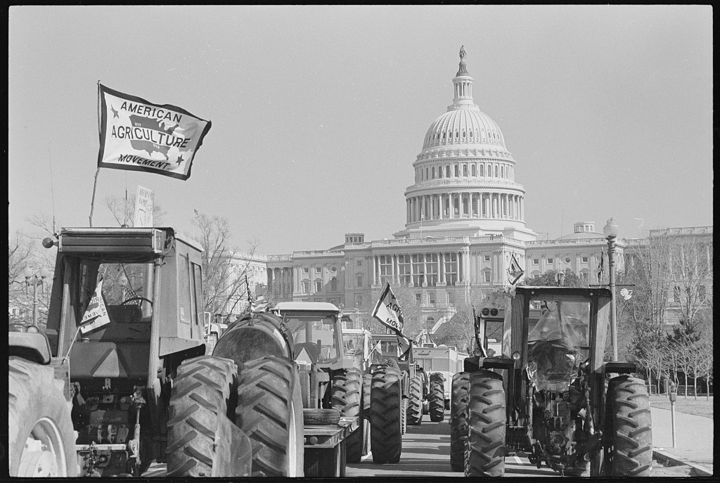
Back in the 1970s, farmers in the Lower Arkansas Valley and across the nation, channeled anger and frustration over low farm prices into a series of large-scale protests, eventually driving their tractors to Washington, D.C., plowing across the national mall.

The American Agriculture Movement, as it was called, was founded in 1977 in the tiny Lower Arkansas Valley community of Campo.

American Agriculture Movement farmers protesting in Washington, D.C. in 1979. Credit: Library of Congress

Now, a new wave of activism is emerging, with Lower Arkansas Valley farmers once again organizing protests and speeches. Their target this time is the City of Colorado Springs and their hope is to stop large annexations that often require taking water from farms to fuel the growth. 

“One of our goals is to make sure the voters in Colorado Springs understand the consequences of this growth. It is not sustainable for them or us,” said Jack Goble, manager of the Lower Arkansas Valley Water Conservation District. Goble’s grandfather was among those who participated in the 1970s protests, although he did not drive a family tractor to D.C., the younger Goble said.

Since the 1980s, communities in the Lower Arkansas Valley have seen their economies shrivel as irrigation water has been siphoned from the Arkansas River by cities. The action gave rise to the term “buy and dry,” a practice now widely condemned.

And it was supposed to end in 2003 with a hard-fought federal court battle and settlement. Since then, state lawmakers and top water and farm agencies have changed laws and spent millions of dollars testing new protective methods for sharing water temporarily between rural and urban areas. They have also spent heavily to improve water quality for thousands of people living near the river who still don’t have clean water to drink.

But farmers say those policies aren’t working.

More transfers underway

In the past five years, Aurora, Pueblo and Colorado Springs have secured more agricultural water, leasing it back to the farmers in some cases when the towns don’t need it, and in others permanently drying up thousands more acres of land.

Faced with housing shortages, and water systems that are under stress due to climate change and chronic drought, cities say they are nevertheless working hard to reduce any impact to farm communities from the water transfers.

“A lot of the farmers are feeling a lot of pressure because of the Aurora purchase,” said Abigail Ortega, referring to the new wave of protests and a deal last year in which Aurora purchased a major farm operation near Rocky Ford and the water associated with that land. Ortega is general manager of water supply planning at Colorado Springs Utilities.

Ortega said Colorado Springs negotiated an agreement with Bent County in which farmers have been paid to dry up sections of land, giving the water associated with those parcels to Colorado Springs. The remainder of the water is tied permanently to their most productive fields. Colorado Springs also paid Bent County millions of dollars up front to aid in economic development, and will make annual payments to the county to offset any decline in farm production, Orgeta said.

“Those payments are meant to mitigate the impacts of taking the water away,” she said.

Despite the water-sharing agreements and new state policies designed to protect growers, Colorado’s irrigated acres have declined nearly 30% in the past 25 years, according to the latest federal agricultural census. That decline has been driven in part by large-scale urban water purchases, as well as declines in Colorado River supplies and legal requirements to deliver water to other states.

In response, growers have adopted a new tactic. In the past six months, they have twice piled into their cars and driven the 100 miles to Colorado Springs City Hall, testifying against two large-scale annexations, with written speeches and signs in hand.

The first, the Amara annexation, would have added 9,500 homes to Colorado’s second largest city. It was narrowly rejected by the Colorado Springs City Council in August.

But the Karman Line annexation was approved last month and will add 6,500 new homes to the El Paso County city.

Lower Arkansas grower Alan Frantz, whose family grows corn, alfalfa and melons and cantaloupes, said the cities need to find other ways to supply water for new homes.

City dwellers, Frantz said, “have blinders on. They want water and they don’t care where they get it. City people don’t know where water comes from. They don’t know where their food comes from. If we didn’t try to tell them, they would not have any kind of clue.”

Council members contacted by Fresh Water News did not respond to a request for comment.

Goble said dozens of growers are ready to confront the city directly as often as it takes until Colorado Springs agrees not to take more water. 

The growers are also joining forces with some Colorado Springs residents who have vowed to ask voters directly this spring to rescind the Karman Line annexation agreement.

“We are going to keep showing up,” Goble said. “These city council members are making decisions that are going to dramatically affect the future of the Arkansas Valley. At some point, you have to live within your water means and stop sacrificing our communities for yours.” 

More by Jerd Smith

Arkansas River Basin via The Encyclopedia of Earth

With two months until snow levels typically peak in #Colorado, Summit County is defying the below-normal trend across the state — Summit Daily #snowpack

Snowpack levels in the Blue River Basin, which includes all of Summit County, are above normal. This winter’s levels are shown in black, last winter’s levels are shown in orange, the 2022-23 winter is shown in purple and the green line shows the 30-year median, or historic norm.
U.S. Department of Agriculture/Courtesy illustration

Click the link to read the article on the Summit Daily website. Here’s an excerpt:

February 6, 2025

The Blue River Basin, which includes all of Summit County, is at 110% of the 30-year median, which is considered the historical normal for snowpack levels in a given area. The dry and warm spell caused the statewide snowpack to slide to 84% of the 30-year median.

Snowpack levels across the entire state are currently below normal. This winter’s levels are shown in black, last winter’s levels are shown in orange, winter 2022-23 is shown in purple and the green line shows the 30-year median, or historic norm.
U.S. Department of Agriculture/Courtesy illustration
While statewide snowpack levels are below normal, areas near Summit County are reporting above-normal levels, as indicated by the green and blue dots.
U.S. Department of Agriculture/Courtesy illustration
Westwide SNOTEL basin-filled map February 6, 2025 via the NRCS.

Water Supply Forecast Discussion February 1, 2025 — Colorado Basin River Forecast Center #ColoradoRiver #COriver #aridification

Click the link to read the discussion on the Colorado Basin River Forecast Center website:

February 1, 2025

The Colorado Basin River Forecast Center (CBRFC) geographic forecast area includes the Upper Colorado River Basin (UCRB), Lower Colorado River Basin (LCRB), and Eastern Great Basin (GB).

Water Supply Forecasts

February 1 water supply forecasts across the CRB and GB are generally below to well below normal and summarized in the figure and table below. Snowpack, soil moisture, and future weather are the primary hydrologic conditions that impact the water supply outlook.

January Weather

Most of January 2025 featured a continuation of the relatively dry, northerly storm track that has dominated the winter season thus far. This pattern continued to favor northern portions of the GB and UCRB, although only limited areas received near to above normal January precipitation. The majority of the CBRFC area was very dry. Many locations in the LCRB have experienced their driest winter to-date on record. Adjacent basins in southern portions of the GB (Sevier) and UCRB (Dolores, San Juan) received near record or record low December–January precipitation amounts.

The large-scale weather pattern changed significantly at the end of January with the development of troughing over the West Coast. This funneled anomalously warm, moist, Pacific air into the Rockies, giving way to heavy precipitation in the northern reaches of the GB and UCRB into early February. Precipitation fell mostly as snow over the critical runoff areas, but given the oceanic origins of the air mass, snow levels became quite high (over 8,000 feet at times). At one point, an NWS employee observed rainfall in the Wasatch at elevations as high as 10,000 feet.

While this welcome pattern change has delivered beneficial precipitation to northern areas, southern portions of the GB, UCRB, and the entirety of the LCRB have yet to pick up any eye-catching precipitation this season. Precipitation is summarized in the figure and table below.

Snowpack Conditions

UCRB February 1 snow water equivalent (SWE) conditions range between 55-110% of normal and are most favorable across west-central CO areas including the White/Yampa, Colorado River headwaters, and Gunnison. SWE is below to well below normal elsewhere across the UCRB, with the least favorable conditions in the San Juan River Basin. UCRB February 1 snow covered area is around 65% of the 2001-2024 median. LCRB February 1 SWE conditions are at or near record low across southwest UT, central AZ, and west-central NM as a result of near record dry winter weather.

GB February 1 SWE conditions range between 50-85% of normal and generally improve from south to north. February 1 snow covered area across UT is around 45% of the 2001-2024 median. SWE conditions are summarized in the figure and table below.

Soil Moisture

CBRFC hydrologic model fall (antecedent) soil moisture conditions impact water supply forecasts and the efficiency of spring runoff. Basins with above average soil moisture conditions can be expected to experience more efficient runoff from rainfall or snowmelt while basins with below average soil moisture conditions can be expected to have lower runoff efficiency until soil moisture deficits are fulfilled. The timing and magnitude of spring runoff is impacted by snowpack conditions, spring weather, and soil moisture conditions.

A very dry June-October 2024 across southwest WY and UT resulted in soil moisture conditions that are below normal and worse compared to a year ago. NW CO soil moisture conditions are near to below normal and similar compared to a year ago. SW CO soil moisture conditions are closer to average and improved from a year ago due to a wetter than normal monsoon (mid-June through September). Monsoon precipitation was near/below normal across the LCRB, where soil moisture conditions are below average and similar compared to last year. CBRFC hydrologic model soil moisture conditions are shown in the figures below.

Upcoming Weather

The atmospheric river regime that arrived at the end of January is continuing into the first week of February. After a lull, confidence is growing in the return of a productive, southerly storm track around the middle of the month. The Climate Prediction Center’s (CPC) 8–14 day precipitation outlook is favoring increased chances of above normal precipitation across the western US during the February 14 20 period. It remains unclear where the focus of moisture will land, but it will likely benefit at least some portions of the CBRFC area. The best hope for the LCRB is that a series of storms tracks far enough south to soften the seasonal deficits. If that does not occur, the LCRB is well on its way to a record, or near record, dry season.

Colorado’s Stream & Wetlands Protection Bill Becomes a Law: Representing the environment as a stakeholder in Colorado’s HB24-1379 rulemaking — Nathan Boyer-Rechlin (Rockies.Audubon.org)

Spotted Sandpiper. Photo: Mick Thompson/Audubon Rockies

Click the link to read the article on the Audubon Rockies website (Nathan Boyer-Rechlin):

January 28, 2025

Colorado is in the midst of a nation-leading rulemaking for its state-waters protection program, established by HB24-1379: Regulate Dredge & Fill Activities in State Waters (HB1379) which Governor Polis signed into law on May 29th. This bill establishes a state regulatory program to permit dredge and fill activities that impact state waters not covered by the Clean Water Act (CWA). This encompasses removal, filling, or other alteration of wetlands and ephemeral streams from activities such as mining and infrastructure development. Audubon Rockies told the story of why Colorado needed new legislation following the Supreme Court’s Sackett Decisionwhich removed crucial wetland protections—and how the bill passed with bi-partisan support in our June 2024 blog post, “A Colorado Program the Colorado Way.”

Ephemeral streams are streams that do not always flow. They are above the groundwater reservoir and appear after precipitation in the area. Via Socratic.org

The core of this program’s regulatory jurisdiction are ephemeral streams and isolated wetlands. Existing federal and state-managed regulatory programs tend to undervalue these types of streams and wetlands, and inadequately mitigate for loss of these habitats and their ecological functions. HB1379 has given Colorado the opportunity to lead the nation in developing a regulatory program that not only fills the gap left by Sackett, but effectively addresses impacts to these key habitats that birds, and humans, rely on. Although the bill set a strong framework for the regulatory program, the gains made during the legislative session could be minimized if the next step isn’t done well. That next step, the rulemaking process, is currently underway.

Anatomy of a Rulemaking

Most of us who grew up with the American public school system likely remember Bill, that “sad little scrap of paper” who only ever dreamed of becoming a law (revisit that Schoolhouse Rock clip for a trip down memory lane). However, what our schoolhouse rock education left out was the long road ahead once poor Bill finally achieves his dream. Sadly for him, it’s not over yet. In most cases, a bill that passes through the state or federal legislature is a sketch or outline which sets the structure and parameters for how a law will function. The rulemaking process fills in the color and detail. 

In our bill’s case, HB24-1379 outlines key requirements and structure for a state program to regulate dredge and fill impacts to state waters which are not covered under the Supreme Court’s current interpretation of the Clean Water Act. The bill directs Colorado’s Department of Public Health and Environment’s (CDPHE) Water Quality Control Commission (WQCC) to develop and promulgate rules detailing how the program will be administered by December 31, 2025. These rules will determine regulatory requirements for stream restoration projects; determine how permits are evaluated, including standards avoiding and minimizing impacts to state waters; and establish a compensatory mitigation program to ensure that all lost stream and wetland functions due to permitted activities are replaced. How these rules are written will determine how effectively the state program meets the bill’s objectives.

CDPHE began convening stakeholders, including Audubon and our partners, in September 2024.  They then released the first draft of new regulations on December 6th. CDPHE is holding monthly stakeholder meetings through November 2025 to build consensus on priorities and draft additional language. WQCC will begin the formal rulemaking process in August 2025, which will include a public comment period for the proposed rules and the rulemaking hearing will be held on December 8, 2025.

What’s at Stake?

The United States Geological Survey’s National Hydrography Dataset estimates that 24 percent of Colorado’s streams are ephemeral and 45 percent are intermittent. These streams provide key habitat for more than 400 bird species throughout Colorado and are vital for mitigating climate and drought impacts, protecting water quality in downstream riverways by capturing sediment and other pollutants, and regulating late season flows and stream temperatures.

Colorado Rivers. Credit: Geology.com

One of the most critical components of a dredge and fill permitting program is compensatory mitigation. In the federal dredge and fill permitting program ((§) 404 of the CWA), which Colorado is modeling its program after, permittees must first avoid and minimize all impacts to regulated waters and then compensate for all unavoidable impacts. Wetland compensatory mitigation most commonly takes place through mitigation banks, where permittees purchase credits from a mitigation bank that has previously constructed wetlands. Mitigation can also be done through an in-lieu fee program or onsite, where the impacts are taking place, by the permittee.

Sunrise Over Wetland by NPS/Patrick Myers

While wetland mitigation has been a well-established practice for decades, stream mitigation has only become common in the last 20 years. Due to challenges unique to streams, and particularly ephemeral streams which are more challenging to create or replace through mitigation banks, stream mitigation has been largely ineffective at replacing the functions lost through dredge or fill impacts. One review of the efficacy of stream mitigation programs found that “existing methods often devalued partially degraded, small, and non-perennial streams and thus discouraged protection and restoration of these stream types.” Developing a compensatory mitigation program that effectively replaces the functions of ephemeral streams that are lost through unavoidable impacts is a key challenge this rulemaking will address.

HB24-1379 included three key provisions to ensure the program adequately protects ephemeral streams and isolated wetlands:

  1. The rules must focus on avoidance and minimization of all adverse impacts [of permitted projects] and describe avoidance and minimization standards.
  2. The rules must implement a compensatory mitigation program for all unavoidable impacts [of permitted projects]. Compensatory mitigation must compensate for all “functions of state waters that will be lost as a result of the authorized activity”
  3. The rules must include an exemption [from permitting] for stream restoration projects in ephemeral streams that are designed solely for ecological lift. Ecological life refers to improvement in the biological and/or hydraulic health of the stream.

While the first draft regulation has been released, many of the sections of the rules that will address these issues are still under development.

Better Together – Working Collaboratively for the Environment

Audubon and our partners have been actively engaged with CDPHE through their stakeholder engagement processes to advocate for strong rules in these three areas. In November, Audubon along with 10 other conservation organizations contributed and signed on to a letter to CDPHE detailing our priorities. This coalition, Protect Colorado’s Waters, also submitted specific feedback on the draft regulations in early January and are continuing to be engaged in advocating for strong rules that ensure avoidance and minimization of wetlands impacts and effective mitigation when needed. Our priorities also include ensuring that qualified stream restoration projects, designed for ecological lift, can continue without undue regulatory burden.

While Audubon and our partners secured a major victory for birds and people with the passing of HB24-1379, our bill’s journey is not done yet. If CDPHE can develop and promulgate rules for this program that ensure that permitted projects are the least damaging available alternative, ensure any lost functions are replaced through mitigation, and streamline permitting for voluntary stream restoration projects, then Colorado’s program will be the first of its kind to effectively protect these vital habitats. To stay engaged and attend future stakeholder meetings, visit CDPHE’s dredge and fill engagement website.

Colorado River headwaters tributary in Rocky Mountain National Park photo via Greg Hobbs.