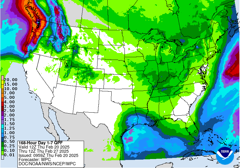
A significant storm system moved through the South and into the Southeast during the week, which was associated with flooding rains over the Tennessee Valley and into Kentucky where some of these areas recorded 7-8 inches of rain or more. Portions of northwest Tennessee had CoCoRaHS reports of over 10 inches of rain over the previous week, with the greatest amount of 11.35 inches outside of Clarksville, TN. Many reports of 3 or more inches of rain were observed from northern Louisiana up to southern Virginia with pockets of northern South Carolina with widespread 6+ inches of rain recorded. With recent dryness and a prolonged rain event, many areas had good infiltration into the soil and even some runoff which helped the local hydrological conditions. The Northern and Southern Plains were mostly dry, with areas of east Texas seeing some benefits of rain. Rain returned to the lower elevations of California and up the West Coast as well as snow in the upper elevations in the West. Temperatures were colder than normal over most of the country, with the greatest departures over Montana and North Dakota where temperatures were greater than 25 degrees below normal. The warmest areas this week were in the Southwest and Southeast, where temperatures were near normal in the Southwest and 5-10 degrees above normal in Florida and southern Georgia…
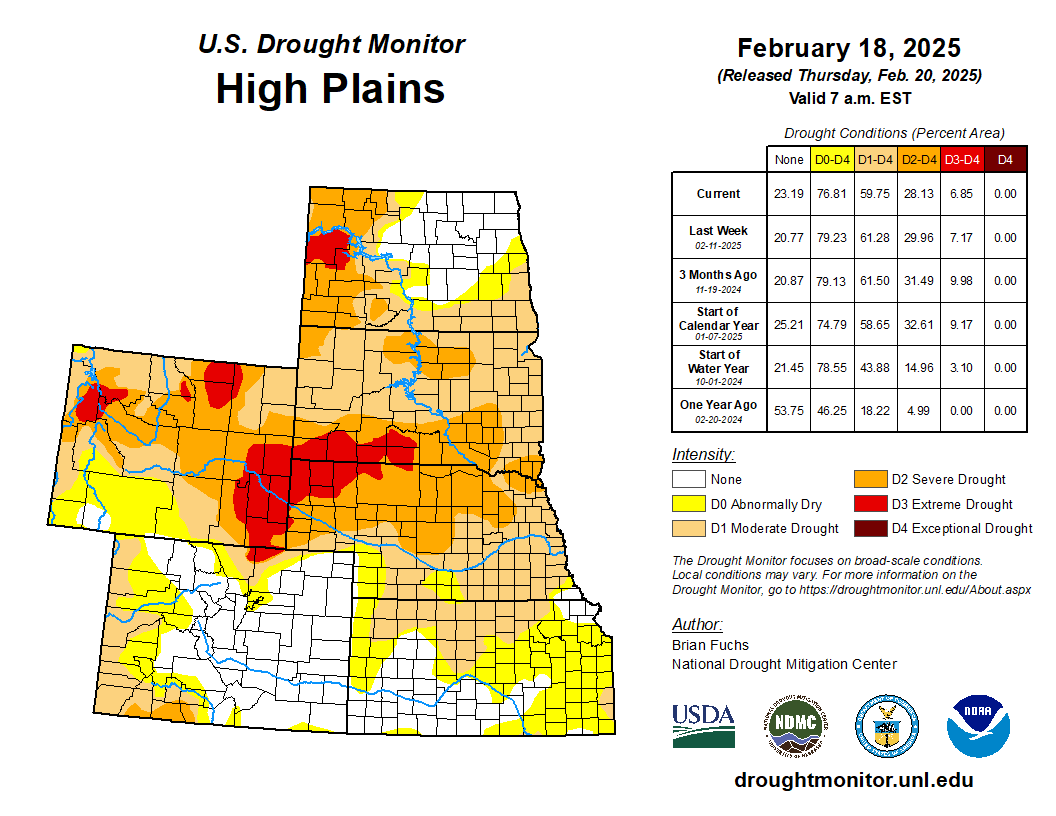
The wettest areas were from eastern Colorado into western Kansas and most of Nebraska where over 200% of normal precipitation was measured. The driest areas were in North Dakota and South Dakota as well as in southern Kansas. It was a cold week for the region with areas of western North Dakota recording departures from normal of 25 degrees or more. Almost all of the High Plains were at least 15 degrees below normal for the week. Only a few slight changes occurred in the region this week, with far southeast Nebraska and far northeast improvements to Kansas’ abnormally dry and moderate drought conditions and abnormally dry conditions removed from northeast Colorado along the Kansas and Nebraska borders…
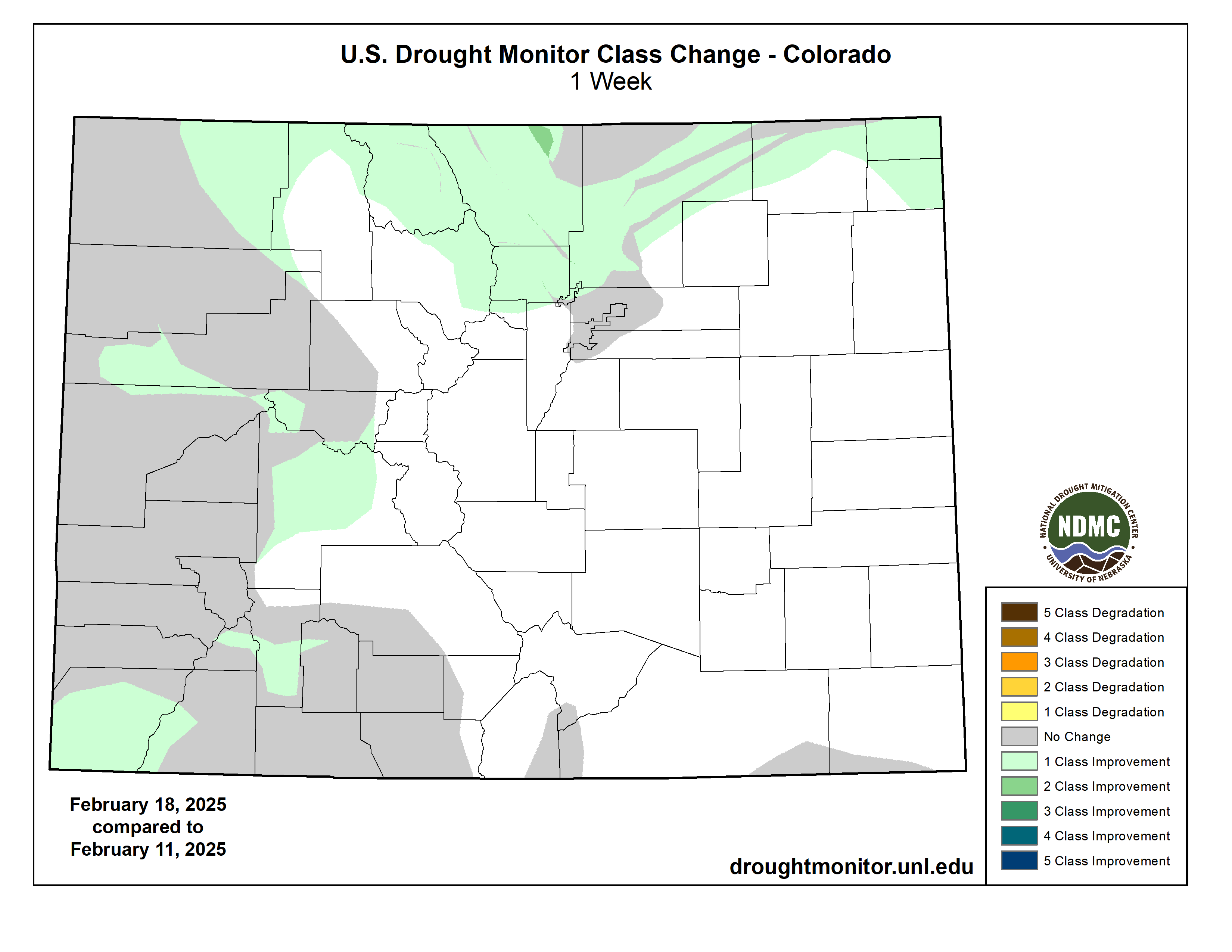
Drought Monitor one week change map ending February 18, 2025.
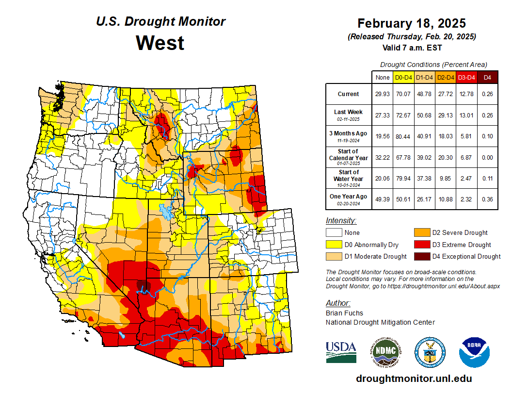
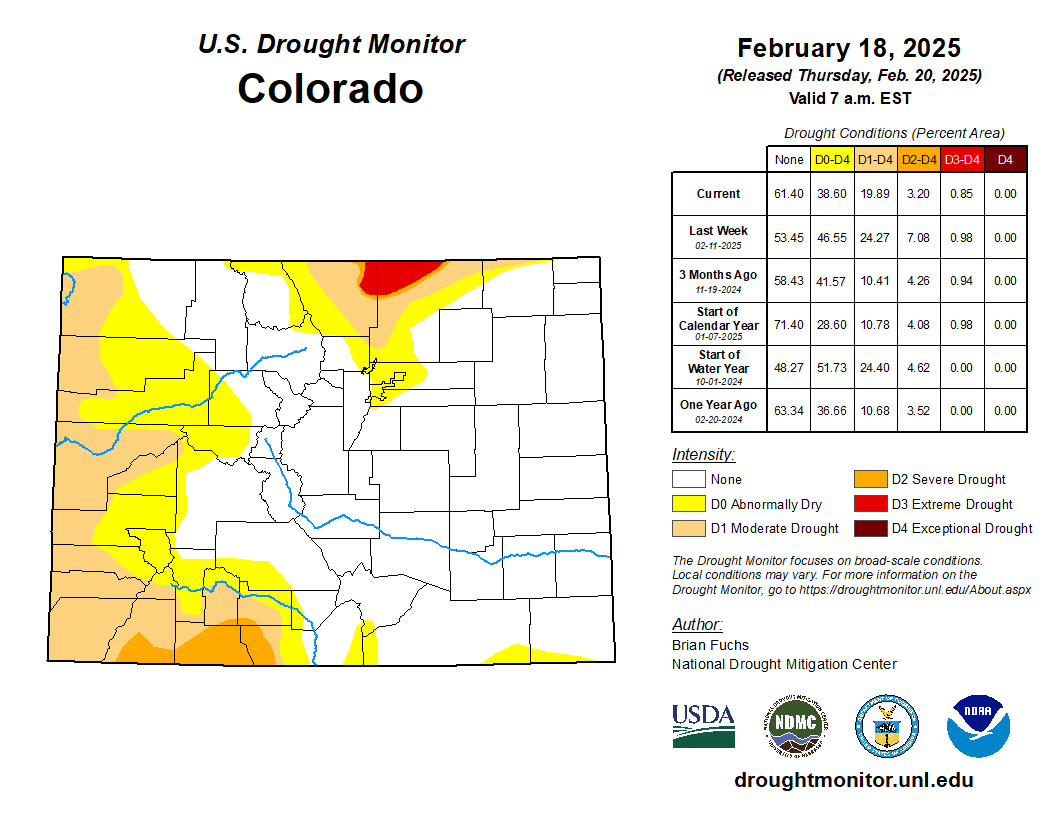
Widespread precipitation occurred over much of the region with only pockets of Nevada, Utah, Wyoming, southern California, southern Arizona and New Mexico missing out. Temperatures were below normal for the region outside of the southern deserts of California, Arizona, and New Mexico where they were near to slightly above normal. The coldest air was over Montana and into Wyoming where departures were greater than 25 degrees below normal. The wetter conditions over California allowed for some improvements in areas where the current water year indicators improved and eased some of the drought conditions. In Washington, continued dryness allowed the expansion of moderate drought in the western portions of the state. Nevada had degradation along the eastern areas, where severe drought expanded, while improvements were made to the moderate drought and abnormally dry conditions of western Nevada. Severe drought expanded over more of western Utah while extreme drought expanded into more of southern Arizona. The last few months have been dry over much of New Mexico coming off a wetter period prior. In looking at the values for the current water year, most areas were holding status quo but degradation to the drought status was made in southwest New Mexico into south central areas of the state. In Colorado, several small snow events occurred, which allowed for some chipping away at the drought designations as conditions showed some improvement. In southwest Colorado, moderate and severe drought improved and in western areas, abnormally dry and moderate drought improved. Northern Colorado continued to have a sharp gradient of areas where drought has developed, and some improvements were made here this week into southern Wyoming. Western areas of Wyoming continue to record better snowfall totals, improving the upper elevation snow numbers for this season. Improvements were made to the abnormal dryness and moderate drought in southern and western Wyoming while in northwest Wyoming, severe and extreme drought improved this week. With the active pattern over Montana as well, the recent improvements made over the last several weeks allowed for minimal changes with only some improvements to moderate drought over western Montana…
The cold from the north made its way into the region with most areas of Oklahoma, north Texas and northern Arkansas all being below normal for temperatures with departures of 6-12 degrees below normal. Areas of central to east Texas, eastern Oklahoma and most areas east of here had the greatest precipitation this week, with some areas of northeast Arkansas and northern Mississippi and Louisiana at greater than 800% of normal. Much of central and western Oklahoma and southern, western and northern Texas were dry this week. Improvements to moderate drought and abnormally dry conditions were made over northern Mississippi and northern Louisiana. A full category improvement was made to all drought and abnormally dry conditions in Tennessee. It was suggested that some of these areas could see more improvement and it was hoped that the hydrological response would allow for this in the coming weeks. The areas that missed out on the rain again did see some degradation, which included the expansion of severe and extreme drought in south Texas and abnormally dry conditions expanded in southern Louisiana…
Looking Ahead
Over the next five to seven days, it is anticipated much of the area in the Southeast and into portions of the South will see additional precipitation with some areas that missed out on the last event potentially recording up to an inch of precipitation with this next storm system. Areas along the East Coast also are anticipated to see additional precipitation while much of the Pacific Northwest and into the northern Rocky Mountains is anticipated to see additional precipitation during this period. Much of the Plains, Midwest and Southwest are anticipated to be dry. In a reversal of recent weeks, warmer-than-normal temperatures are expected over much of the area from the Plains westward with departures of 13-16 degrees above normal over much of the Southwest. The areas east of the Plains are anticipated to be near normal.
The 6-10 day outlooks show the high probability of warmer-than-normal temperatures over the western half of the country, with the best probability of above-normal temperatures over the Southwest and portions of the High Plains. The greatest chances of below-normal temperatures will be over Florida. The greatest probability of above-normal precipitation will be along the Canadian border with the best chances of above-normal precipitation in portions of the High Plains, Midwest and New England. Above-normal chances of below-normal precipitation will be over much of the West, southern Rocky Mountains and southern Plains.
US Drought Monitor one week change map ending February 18, 2025.
Well, with the fate of constitution democracy in the courts where we know the mills grind slowly (as opposed to the grinders who break things quickly); and with the money frozen for farmers doing well by doing good in water conservation; and neither white smoke nor black smoke arising from the chimneys of the enclaves trying to envision the next decade or so for the Colorado River – I’ll take a break from my wonkish efforts to think outside the box, to remember a friend and mentor, and friend of the River, who thought outside the box often in the last half of the 20th century.
The cantankerous Colorado River water community recently lost a valued member, L. Richard Bratton, a water attorney in the Upper Gunnison River Basin from 1958 till his death January 28.
Dick Bratton’s scope of influence went beyond the Upper Gunnison mountain valleys, however; he was a creative thinker who never met anyone he could not talk to – or listen to, or work with. A born “connector,” he became an active player in events on the cusp of major changes in the development of water in the entire Upper Basin of the Colorado River.
Born in 1932 and raised in Salida, Dick Bratton came to Gunnison to attend Western State College, then went to the University of Colorado Law School. While at school in Gunnison, he had met Ed Dutcher, a somewhat legendary West Slope water attorney. Shortly after Bratton completed law school, Dutcher invited him to join his firm in 1958.
Aspinall Unit dams
Bratton joined Dutcher’s firm that year – and in 1959, the Colorado River Storage Project (CRSP) came to the Upper Gunnison River Valley in a big way, with Congressional approval of funding for CRSP’s Curencanti Project (Blue Mesa, Morrow Point and Crystal Dams, now renamed the Wayne Aspinall Unit), and he found himself plunged into all of the ongoing and emerging challenges faced by small communities with agrarian roots in an urbanizing and industrializing world.
The first challenge was Theodore Roosevelt’s conservation vision. The “Father of American Conservation” had a different view of conservation than most of us have today; to him and his philosopher sidekick Gifford Pinchot, conservation meant first the orderly development of resources otherwise wasted – like the Colorado River pouring itself into the sea in a two-month uncontrolled and mostly unused flood of snowmelt. And when it came to what should be developed and by and for whom, their rule was “the greatest good for the greatest number,” with “for the longest time” sometimes remembered, sometimes not.
In the Upper Gunnison, the Bureau of Reclamation had chosen the Curecanti Reservoir site not to benefit the small ranches and farms of the Upper Gunnison valleys, in accord with their original Rooseveltian mission. It was chosen because it was a great site for a major reservoir in a regional water development for four states that were paranoid over their obligation to make sure a set amount of water passed on to the three more populous states below the Colorado River canyons. The greatest good for the greatest number.
The Curecanti Reservoir as originally proposed, however, would have backed 2.5 million acre-feet (maf) of water almost up to the city limits of Gunnison, with the shallow end exposing major mudflats every summer as the reservoir was drawn down, and the prevailing westerlies would have turned Gunnison into a dust bowl. Bratton’s partner and mentor Ed Dutcher had invested much of his career into opposing this local sacrifice for the greatest good for the greatest number – not just standard NIMBYism; the community was fighting for its life, and also for the life of two small towns that would be inundated along with 30 miles of legendary fishing stream, 23 small river resorts, and 6,000 acres of ranchland.
After much noisy negotiation with the Bureau of Reclamation for Dutcher and his “Committee of 39,” the Bureau dropped the reservoir size to just under one million acre-feet, saving Gunnison from the dust inundation, but still losing the two smaller towns and their economic activities – and the great fishing.
Being sensitive to the cost the project was imposing on the ranchers and farmers that the Bureau was actually created to serve, however, an “Upper Gunnison River Project” with seveeral small reservoirs was included as a future participating project in the CRSP Act, to be paid for partially by the revenues from the hydroelectric plant on the three largest CRSP dams: Glen Canyon, Flaming Gorge and the Curecanti Unit.
So one of Bratton’s first jobs in Gunnison was helping talk the people of the valley into taxing themselves a little to create an Upper Gunnison River Water Conservancy District under state law, both to help the Bureau lobby for project funding in Washington, and to nudge and harass the Bureau into getting project planning and execution done. Creating the Conservancy was accomplished in an election in 1959, a busy year for Dutcher and Bratton.
In 1961 Dutcher was appointed to a judgeship, and Bratton took over the law firm. That same year, the Bureau opened an office in Gunnison, and began the preliminary work for the Curecanti Project – clearing the land of trees, relocating roads, and buying out all of the human occupants, an unpleasant and depressing process in the valley. The “greatest good for the greatest number” rule, applied in many areas other than conservation, has nothing in the formula for the “lesser numbers” – probably one source of our current urban-rural troubles.
As construction proceeded on the Curecanti dams, though, a “big pivot” in the way the entire nation perceived the American West was becoming unignorable. The Bureau of Reclamation had depended on the willingness of the American people to continue investing in the “reclaiming” of arid lands to create more of the iconic “family farms” and to otherwise further the development of raw resources to feed the people and industries of an increasingly urbanized and industrialized economy. But the increasingly urbanized, industrialized – and after the Second War, increasingly mobilized – American people were enjoying a rising standard of living that included more time for recreation – paid vacations! – and “their” western public lands were increasingly perceived not as a resource hinterland, but as a vacation paradise, to be kept as pure and pristine as possible with millions of people trampling through.
On Bratton’s home front, the Crested Butte Ski Resort also opened in 1961 upvalley, forcing the beginning of a transition in the Upper Gunnison’s self-perception as part of the mining, farming and ranching “working west,” as opposed to a service sector serving visitors to the great western playground. “Conservation” was swinging from the Rooseveltian orderly development of otherwise “wasted” resources toward conservation as careful guarding of the West’s resources, including preservation of its residual wild magnificence, Wallace Stegner’s “society to match its scenery.”
Bratton himself was the son of a “working west” family, with a couple generations before him in Colorado engaged in mining and mining-related economic activities. But like the political creator of the Colorado River Storage Project, West Slope Congressman Wayne Aspinall, Bratton could see where things were going, and worked to make the transition at home as non-disruptive as possible for the “Old West” yielding to the “New West.” (Aspinall’s CRSP Act included provisions for recreational facilities around the major dam sites – but also provisions for a number of “Old West” valley-scale projects that could not meet cost-benefit analyses on their own without assistance from hydropower revenues.)
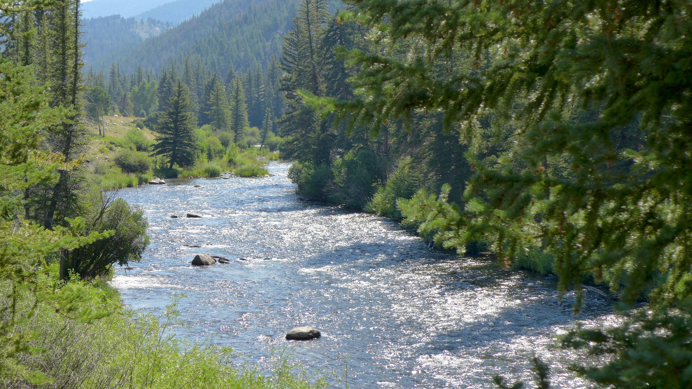
The Taylor River, jewel of the Gunnison River basin. Photo: Brent Gardner-Smith/Aspen Journalism
The creative quality of Bratton’s work in that transition is probably best shown in the story of the resurrection of the Taylor River. The Taylor River collected runoff from some of the highest and snowiest peaks of the Continental Divide and came down to the Gunnison River through 25 miles of canyons – a beautiful mountain river with a reputation among “anglers” (don’t even say “bait”) as a world-class fishery, even in the early 20th century.
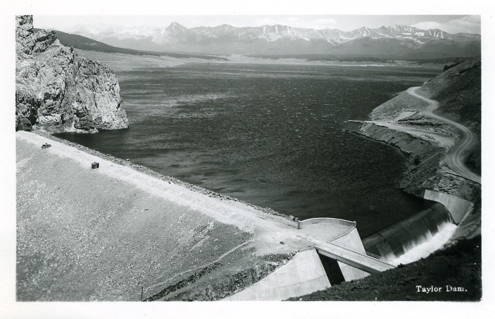
But in the 1930s, the Bureau put a dam at the head of the canyons to store late-season water for farmers in the Uncompaghre River valley, more than a hundred miles downriver at the receiving end of the Gunnison Tunnel, the Bureau’s first big transbasin water project. That project to make life better for distant farmers effectively killed the Taylor and its aquatic life as a river, reversing its natural wet and dry cycles and turning it into an irrigation canal that ran at the will of the Bureau. This was a great loss to the people of the Upper Gunnison, who knew that the best time for fishing was after work anyway. The loss of the Taylor was their first lesson in what the greater good for a greater number meant for the lesser number.
And the Curecanti Project was their second lesson, inundating another twenty-some miles of world-class fishery, along with two small towns and a fishing-resort community that made decent livings from the river. But the Upper Gunnison farmers and ranchers held out hope that, once the Curecanti Unit was in place to play its role in the larger world of Colorado River Basin policy and politics, the Bureau would at least fulfill its promise and begin work on the Upper Gunnison River Project to give them a little help with late-season water.
But just in the decade-and-a-half from the difficult passage of the CRSP Act in 1956 to the completion of the Curecanti Project, public support for expensive irrigation projects to develop western lands basically dried up, replaced by active opposition to anything disturbing the natural beauty and magnificence of The West. It became obvious to the Upper Gunnison Conservancy board and Bratton – attorney on retainer to the board for its first 40 years – that there would be no federal funds for an Upper Gunnison River Project.
But Bratton – a convener and collaborator who managed to maintain good working relationships even with opponents – started to play on the Bureau’s guilt at not being able to fulfill their promise to the people of the Upper Gunnison. He found a willing collaborator in Bob Jennings, a Bureau manager in the West Slope office. Together, they devised a plan whereby the Bureau would let the Uncompaghre Valley Water Users Association store their Taylor Reservoir water in the Blue Mesa Reservoir – at least a day closer to where the water would be used. Then the water could be moved from the Taylor Reservoir down to Blue Mesa from in a schedule more in tune with the natural flow of a river. Maybe the Bureau could not create small upstream reservoirs for the “Old West” agrarian economy, but it could facilitate the resurrection of a beautiful river for the “New West” economy taking shape (and Old West workers who liked to fish).
This was accomplished with a 1975 agreement among the Uncompahgre Valley farmers, the Colorado River Water Conservation District, the Upper Gunnison River Water Conservancy, and the Bureau. The Bureau would manage the “new” river, but with input from the other three parties – input that begins each spring with a meeting of an Upper Gunnison River “Local Users Group”: representatives from Taylor River irrigators, whitewater recreation businesses, Taylor Reservoir flatwater businesses, anglers, and riparian residents. This group sits down with projections for the summer runoff, and compile suggestions for the Bureau on the operation of the Taylor River that will meet all their needs more or less (and being sure to get the Uncompahgre farmers’ water down to Blue Mesa storage in a timely way). The Bureau and other parties can override their recommendations, but seldom need to. And the Taylor is a beautiful mountain river again – “unnatural” only in being democratically operated by all of its Old West and New West users.
Bratton did not stop there. He led the Upper Gunnison River Water Conservancy District through the process of filing for rights on a secondfill of the Taylor Reservoir. Taylor Park above the reservoir gathers on average half again the 110,000 af needed for the Uncompahgre users first fill. Any water collected in a second fill would be left in the river, for wildlife and other environmental benefits downriver – a right consistent with Colorado’s 1973 instream flow law, to sustain the aquatic and riparian environment “to a reasonable degree.” This water right, inconceivable before the 1970s and NEPA awarenesss, was granted in 1990 – just in time to help thwart a proposal for a transmountain diversion to the Front Range from the adjacent Union Park.
Even then, Bratton was not yet done playing on Bureau guilt for imposing the Curecanti Unit on the Upper Gunnison with no compensatory project for the local water users – even though the Upper Gunnison community generates a lot of economic activity from the Curecanti National Recreation Area around Blue Mesa Reservoir. Early in the 21st century, Bratton wanted to develop some ranchland he owned adjacent to the City of Gunnison, with a tributary of the Gunnison River running through it. This development was not received by local residents with any great enthusiasm.
But Bratton remembered a ‘handshake agreement’ with the Bureau from the Curecanti construction era, that the Bureau would replace the great sport fishery the reservoir would inundate with some good public access fishing streams elsewhere in the basin. So rather than developing a standard golf-course-rimmed-with-expensive-homes development, Bratton reminded the Bureau of its promise, and sold it the stream corridor through his land for public access, to be managed by Colorado Parks and Wildlife.
Bratton was also deeply committed to his alma mater, Western State College (now Western Colorado University). In 1975 – obviously a busy year in his life – he orchestrated the creation of the Western State College Foundation, with bequests from former Colorado Governor Dan Thornton and his wife Jessie, valley ranchers; the Foundation continues as an important support for program development at the University.
The following year, 1976, he collaborated with Western history professor Duane Vandenbusche on a water education course. The next year, 1977, that evolved into the “Western Water Workshop,” to which Bratton invited an incredible lineup of speakers, including – in the same room – longtime West Slope Congressman Wayne Aspinall, Denver Water’s longtime chief counsel and bitter West Slope adversary Glenn Saunders, Assistant Bureau of Reclamation Director Cliff Barrett, former Governor John Vanderhoof, and a number of other luminaries of the “water buffalo era.” Your author was privileged to sneak into those summer sessions – one of the most memorable of which was Bureau man Cliff Barrett trying to suss out the implications of President Carter’s recently released “hit list,” a list of water projects, including a number of CRSP projects, that did not meet a new cost-benefit analysis – essentially the official end of the era of federally-funded western water development.
The Western Water Workshop continued for forty years; a place where East Slope and West Slope, Old West and New West participants could gather for a couple days of off-the-record escape from the physical and cultural heat of the cities in the summer. I sserved as director of the Workshop for six year after the turn of the century until I retired from Western, and I found Dick Bratton to still be a great resource and idea person. At that time he had been appointed by President G. W. Bush to be the federal representative on the Upper Colorado River Commission. He once took pains to save my Water Workshop job when I had inadvertently offended one of the old “water buffalo” with a couple invitees to a session; Bratton reminded his old friend that the Workshop promised “the presentation of all reasonable points of view.”
The reader may feel this article is more a history lesson than the remembrance of a man. (A full obituary can be found in the Feburary 6 Gunnison Country Times – www.gunnisontimes.com) But it is my feeling that some people cannot be understood outside of the history they are part of, and Dick Bratton was such a person. Like his friend Wayne Aspinall, he tried to help Colorado’s West Slope (and the larger intermountain West) negotiate the difficult, inevitable, and ongoing transition from the “Old West working economy” to the “New West amenity economy.” His heart may have been more with the former, but he became at home with the latter because, basically, he was at home in the world, whatever it was, and enjoying working with whomever he encountered there. And he was a fisherman as well as the son of a miner.
More than a year after an environmental group sued to stop a $2 billion northern Colorado water project, whispers of a settlement are being heard as the case winds its way through U.S. District Court in Denver.
Last January, Save The Poudre sued to block the Northern Integrated Supply Project, a two-reservoir development designed to serve tens of thousands of people in northern Colorado. The suit alleged that the Army Corps of Engineers had not adequately weighed the environmental impacts and less harmful ecological alternatives to the project…
Colorado-Big Thompson Project map. Courtesy of Northern Water.
Northern Water, which operates the federally owned Colorado-Big Thompson Project for the U.S. Bureau of Reclamation, is overseeing the permitting and construction of NISP. The agency also declined to comment on any potential settlement. Northern Water serves more than 1 million Front Range residents and hundreds of growers in the South Platte River Basin.
“We’re still moving forward with what we need to do on the litigation,” Northern spokesman Jeff Stahla said.
Northern Water’s board discussed the litigation in a confidential executive session last week at a study retreat and it is scheduled to discuss it in another private executive session Feb. 13 at its formal board meeting, according to the agenda.
Sources told Fresh Water News and The Colorado Sun that those discussions are related to the potential multimillion-dollar settlement.
Key developments this past year
In October, a federal judge delivered a favorable ruling to Wockner’s Save the Colorado on a case involving Denver Water’s Gross Reservoir expansion project. Now [envisonmental groups] are seeking an injunction to force Denver Water to stop construction of the dam, which began in 2022.
Workers from Denver Water and contractor Kiewit Barnard stand in front of Gross Dam in May to mark the start of the dam raise process. Photo credit: Denver Water.
Raising the Boulder County dam by 131 feet will allow Denver Water to capture more water from the headwaters of the Upper Colorado River on the Western Slope. In its ruling, the federal court said the U.S. Army Corps of Engineers had failed to consider the impact of climate change on the flows in the Colorado River.
What impact that ruling may have on the NISP case isn’t clear, but [the environmental group that sued Denver Water] said they believe it will give his organization more leverage to push for changes in NISP.
In addition, the City of Fort Collins has dropped its formal opposition to NISP. And Stahla said Northern has continued to push forward with key parts of the development, including the design work needed to relocate a 7-mile stretch of U.S. 287 northwest of Fort Collins.
Fort Collins Mayor Jeni Arndt said the city changed its stance because most of its environmental concerns had been met through the 21-year federal permitting process.
“The EPA had signed off, and the Corps of Engineers had signed off,” she said. “It was obvious that this was not going to be another Two Forks,” referring to a massive dam proposed in the 1970s by Denver Water on the South Platte River near Deckers. It was rejected by the EPA due to environmental concerns.
Arndt said the city also planned to use a later review process, known as a 1041 review, to address other environmental concerns that might arise.
If NISP is ultimately built, and most believe it will be, it will provide water for 15 fast-growing communities and water districts along the Interstate 25 corridor, including the Fort Collins-Loveland Water District, Fort Morgan, Lafayette and Windsor.
The largest participant in the giant project is the Fort Collins-Loveland District. Board member Stephen Smith said he believes NISP will move forward one way or another and that it is critical to serving the water-short region.
“NISP is going to get built and it will provide water to Fort Collins by 2033,” he said.
The Northern Integrated Supply Project, currently estimated at $2 billion, would create two new reservoirs and a system of pipelines to capture more drinking water for 15 community water suppliers. An environmental group is now suing the Army Corps of Engineers over a key permit for Northern Water’s proposal. (Save the Poudre lawsuit, from Northern Water project pages)
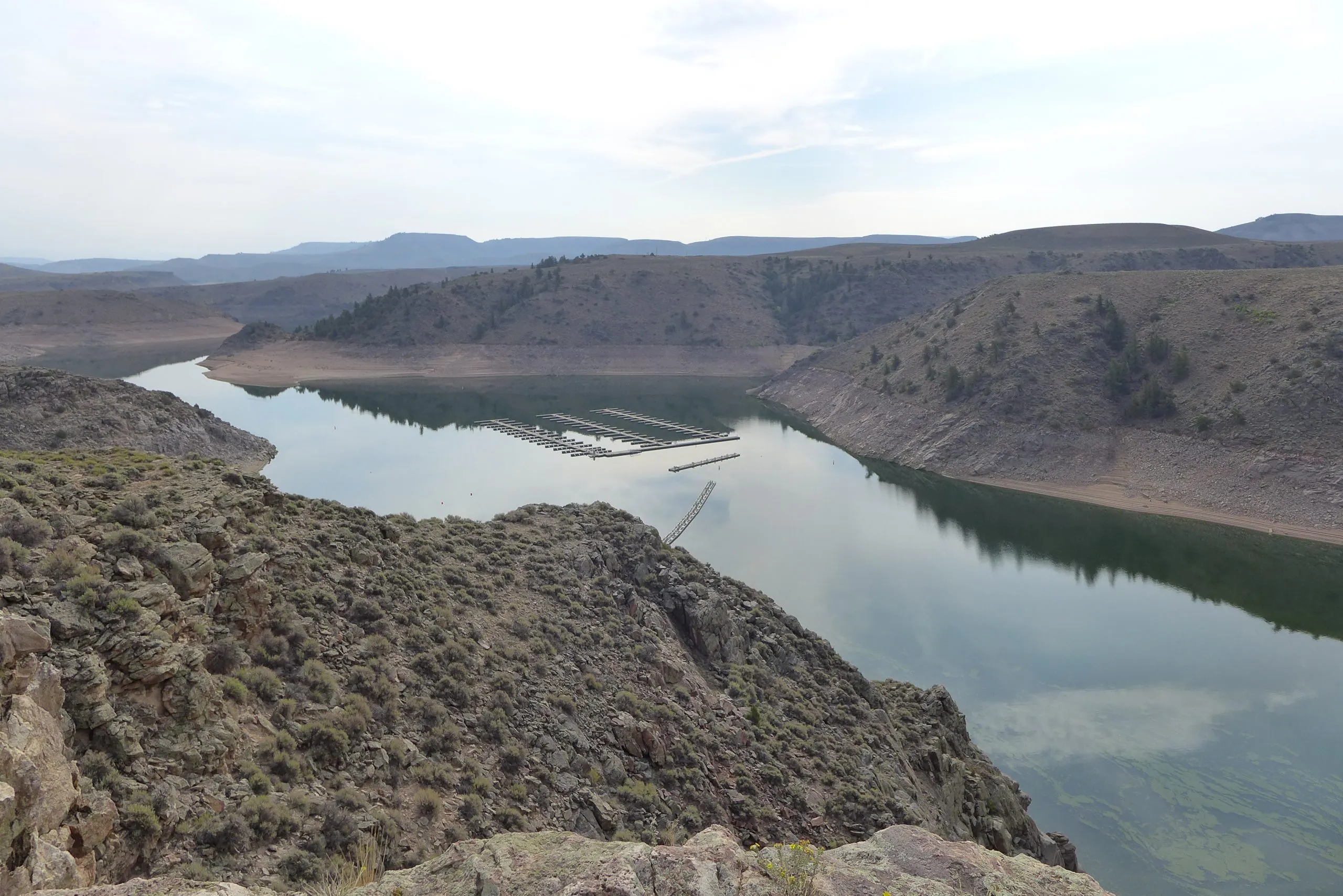
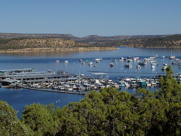
Elk Creek Marina at Blue Mesa Reservoir on the Gunnison River was temporarily closed so the docks could be moved out into deeper water in 2021 after federal officials made emergency releases from the reservoir to prop up a declining Lake Powell. Upper Colorado River Basin officials are requesting monthly drought-monitoring meetings with the U.S. Bureau of Reclamation in hopes of avoiding future last-minute emergency releases. Credit: Heather Sackett/Aspen Journalism
Water managers are preparing for another potentially lackluster runoff this year in the Colorado River Basin.
At a meeting Tuesday, water managers from the Upper Colorado River Commission agreed to write a letter to the U.S. Bureau of Reclamation asking for a monthly meeting to monitor drought conditions. Officials from the four Upper Basin states (Colorado, New Mexico, Utah and Wyoming) are hoping to avoid a repeat of 2021 when emergency reservoir releases caught them off guard.
“We want to be as prepared as possible since hydrology has flipped pretty quickly in previous years,” said UCRC Executive Director Chuck Cullom. “We think it’s prudent to collectively review the forecast and the water supply so that we aren’t caught in the situation we were in in 2021.”
Pine River Marina at Navajo Reservoir. Photo credit: Reclamation
From July through October of that year, Reclamation made emergency releases from three Upper Basin reservoirs: 20,000 acre-feet from Navajo, on the San Juan River; 125,000 acre-feet from Flaming Gorge, on the Green River; and 36,000 acre-feet from Blue Mesa, on the Gunnison River. The goal was to boost water levels at Lake Powell, which had fallen to a critical elevation, and ensure that Glen Canyon Dam could still produce hydroelectric power.
View below Flaming Gorge Dam from the Green River, eastern Utah. Photo credit: USGS
Guidelines for Upper Basin reservoir releases are laid out in the Drought Response Operations Agreement, which was signed in 2019 by the Upper Basin states and the federal government. The three reservoirs are part of the Colorado River Storage Project, and the federal government can authorize emergency releases from them without permission from the states or local entities.
But Colorado water managers were not happy about the timing or lack of notice from the bureau when the emergency releases happened in 2021. Drawing down Blue Mesa, Colorado’s largest reservoir, during the height of the summer boating season forced marinas to close early for the year and was a blow to the state’s outdoor recreation economy.
“It’s February, and we are seeing hydrology that could potentially impact reservoir operations,” Cullom said. “Let’s plan for it rather than reacting over a weeklong period. We’re trying to preempt some of the concerns and criticisms of reservoir operations in 2021.”
Water year 2021 was historically bad, with an Upper Basin snowpack that was near normal at 93% of average but translated to only 36% of average runoff into Lake Powell, the second-worst runoff on record. One of the culprits was exceptionally thirsty soils, which soaked up snowmelt before runoff made it to streams, due to 2020’s hot and dry summer and fall.
Credit: Laurine Lassalle/Aspen Journalism
Officials said current conditions could be setting the basin up for another year like 2021. Alex Pivarnik, a supervisor with the bureau’s Upper Colorado Operations Office, presented the latest data to commissioners Tuesday.
“Coming into the winter, soil-moisture conditions were pretty much dry throughout most of the basin,” Pivarnik said. “And January was a really bad month for us in the basin. … Coming into February, it was kind of a make-or-break for us.”
February’s “most probable” modeling projection for spring runoff into Lake Powell is 67% of average. The February forecast for total Powell inflow for water year 2025 is 71% of average.
Those numbers, taking into account snowpack conditions up until Feb. 5, were down from January’s most probable runoff forecast, which put Lake Powell’s spring inflow at 81% of average and total Powell inflow for water year 2025 at 82% of average.
After a storm cycle that brought snow to mountain ranges throughout the Upper Basin over Presidents Day weekend, snowpack for the Upper Basin stood at 94% of median as of Wednesday. In 2021, Upper Basin-wide snowpack on Feb. 19 was 89%.
“While the snow brought us some positivity, I still like to remind folks when we see Lake Powell at 35% full, that means it’s 65% empty and that’s troubling,” said Becky Mitchell, Colorado’s representative to the UCRC. “I want to note that we’ve been slightly optimistic because of the snow, but it still does not look as good as we’d like.”
Mitchell acted as chair of Tuesday’s UCRC meeting after former chair and federal representative Anne Castle was asked to resign by Trump administration officials last month. A new federal representative to the UCRC has not yet been appointed.
Snowpack for the Upper Colorado River Basin, water years 2021 vs. 2025
This chart shows how much snowpack has been measured at various SNOTEL stations located in the Upper Colorado River Basin.
Snowpack for the Upper Colorado River Basin, water years 2021 vs. 2025 This chart shows how much snowpack has been measured at various SNOTEL stations located in the Upper Colorado River Basin. Chart: Laurine Lassalle – Aspen JournalismSource: SNOTEL Get the dataCreated with Datawrapper
This is a critical time for Colorado River management as the Upper Basin states are in talks with the Lower Basin states (California, Arizona, Nevada) about how the nation’s two largest reservoirs, Lake Powell and Lake Mead, will be operated and cuts will be shared after 2026 when the current guidelines expire. Overuse, drought and climate change have driven reservoir levels to their lowest points ever in recent years.
Cullom gave an overview of the timeline needed to implement a new plan for post-2026 operations. The seven basin states need to reach agreement on a plan by early summer; the bureau would issue a final environmental impact statement by the spring of 2026 and a record of decision by August 2026. New guidelines would take effect in water year 2027, which begins Oct. 1, 2026.
Negotiations with the Lower Basin states, which ground to a halt at the end of 2024, have resumed, and Upper Basin commissioners said they are hopeful that they will reach a consensus. Failure to do so would mean river management decisions would be imposed by the federal government, which is something that state representatives want to avoid.
“A consensus is the best option out there for everyone, and I’m hopeful that we’ll get there,” Mitchell said, adding that “the highest level of certainty that we will have as seven basin states is if we can determine our own future. … I want to reiterate that we are committed to work with the Lower Basin states toward that seven-state consensus.”
Udall/Overpeck 4-panel Figure Colorado River temperature/precipitation/natural flows with trend. Lake Mead and Lake Powell storage. Updated through Water Year 2024. Credit: Brad Udall