Click on a thumbnail graphic to view a gallery of drought data from the US Drought Monitor website.


Click the link to go to the US Drought Monitor website. Here’s an excerpt:
This Week’s Drought Summary
In the last week, a few swaths of precipitation occurred across the country, including the Sierra Nevada, northwest California and western portions of Washington and Oregon. Some high elevation areas of the West received precipitation as well, mostly outside of the desert Southwest. Some areas of the Upper Midwest and Northeast received a quarter of an inch of precipitation to locally over an inch. At the end of the current drought monitoring period (Tuesday morning), a powerful storm system was emerging into the Great Plains, delivering thunderstorms, high winds and wind-driven snow to parts of the Great Plains and Midwest. While some of this precipitation fell overnight Monday into early Tuesday morning, most of this precipitation will not be accounted for until next week’s U.S. Drought Monitor (USDM) update. Temperatures generally ranged from 5-15 degrees warmer than normal in the Great Plains, with locally warmer readings in the Dakotas and eastern Montana. With some exceptions, temperatures were mostly within 5 degrees of normal across the rest of the Contiguous U.S.
The Southeast U.S. had a mostly dry week, which led to degradations to short- and long-term drought conditions across parts of the Carolinas, Georgia, Alabama and Florida. Mostly dry weather in the lower Midwest and southern Great Plains led to expansion of ongoing abnormal dryness and drought. Drought coverage and severity also increased in the Southwest and in Hawaii, while short-term abnormal dryness developed in south-central Alaska. Improvements to snowpack in parts of Idaho, western Wyoming and southwest Montana led to some improvements to conditions there…

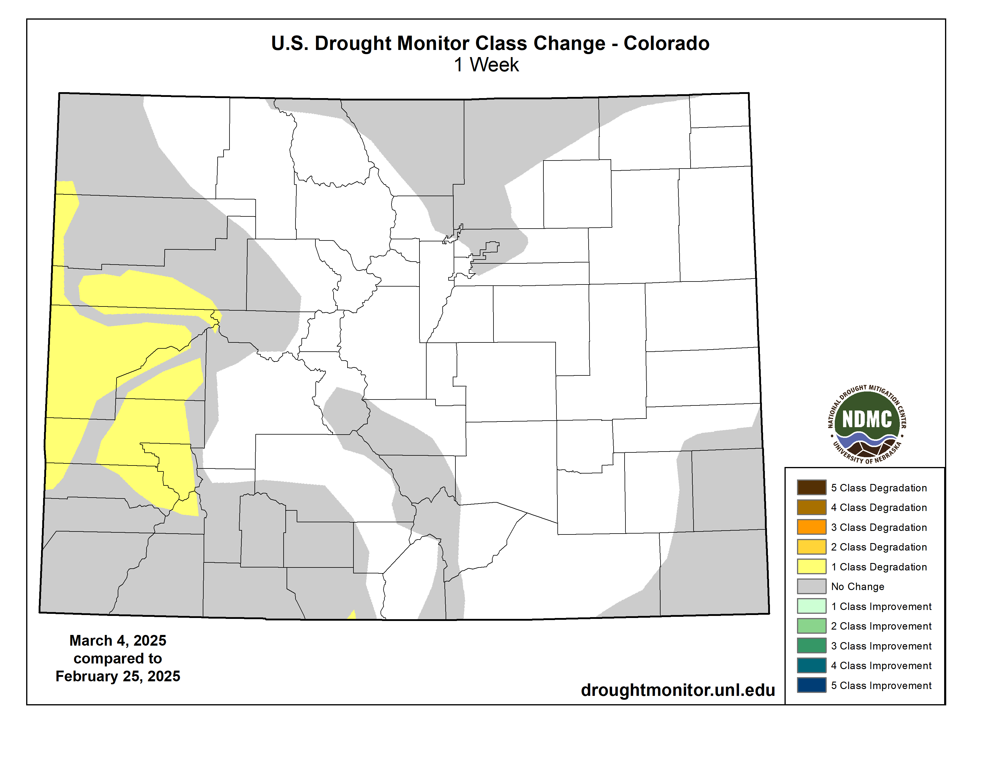
High Plains
Temperatures across most of the High Plains were above normal, with most locations east of the Rocky Mountains finishing the week between 9 and 15 degrees warmer than normal. Some precipitation fell in mountainous areas of Colorado and Wyoming, and snow occurred Monday night into Tuesday morning in parts of the northeast Colorado plains into western and central Nebraska. Most of the High Plains region east of the Rocky Mountains did not see any changes to ongoing drought or abnormal dryness, except for southern Kansas, where abnormal dryness expanded in response to unusually dry weather in the last few months. In western Colorado, moderate and severe drought expanded in coverage due to very low snowpack and growing precipitation deficits. Recent precipitation in west-central Wyoming led to localized improvements to drought conditions there…
West
Precipitation fell across higher elevations of California, northern Idaho and western areas of Oregon and Washington this week. For the most part, drier weather occurred elsewhere. Temperatures were warmer than normal in most of the West, with the warmest conditions of 9-15 degrees above normal occurring in the central and eastern plains of Montana. Recent improvements to snowpack in northeast Nevada, Idaho and southwest Montana led to localized improvements to drought conditions. Meanwhile, to the south across Utah, Arizona and New Mexico, this week’s continued dry weather led to widespread drought degradation as short- and long-term precipitation deficits grew amid soil moisture, streamflow and groundwater deficits. Drought conditions are especially bad from Phoenix westward to far southeast California, where exceptional drought developed this week…
South
Temperatures across the South this week were mostly warmer than normal, with much of Texas and Oklahoma finishing the week 6-10 degrees above normal. A line of thunderstorms associated with this week’s powerful low-pressure systems produced widespread rain of 0.5-1 inches in central and western Oklahoma and central north Texas, though areas east of there did not receive precipitation from this storm system until after the Tuesday morning data cutoff. Scattered drought degradations occurred in the western halves of Texas and Oklahoma, due to increasing precipitation deficits and locally decreasing streamflow and soil moisture. Groundwater and reservoir levels continued to drop in central Texas in the San Antonio area amid very large precipitation deficits, leading to the development of a small area of exceptional drought. Similar conditions in southwest Texas led to the expansion of exceptional drought along the Rio Grande to the El Paso area…

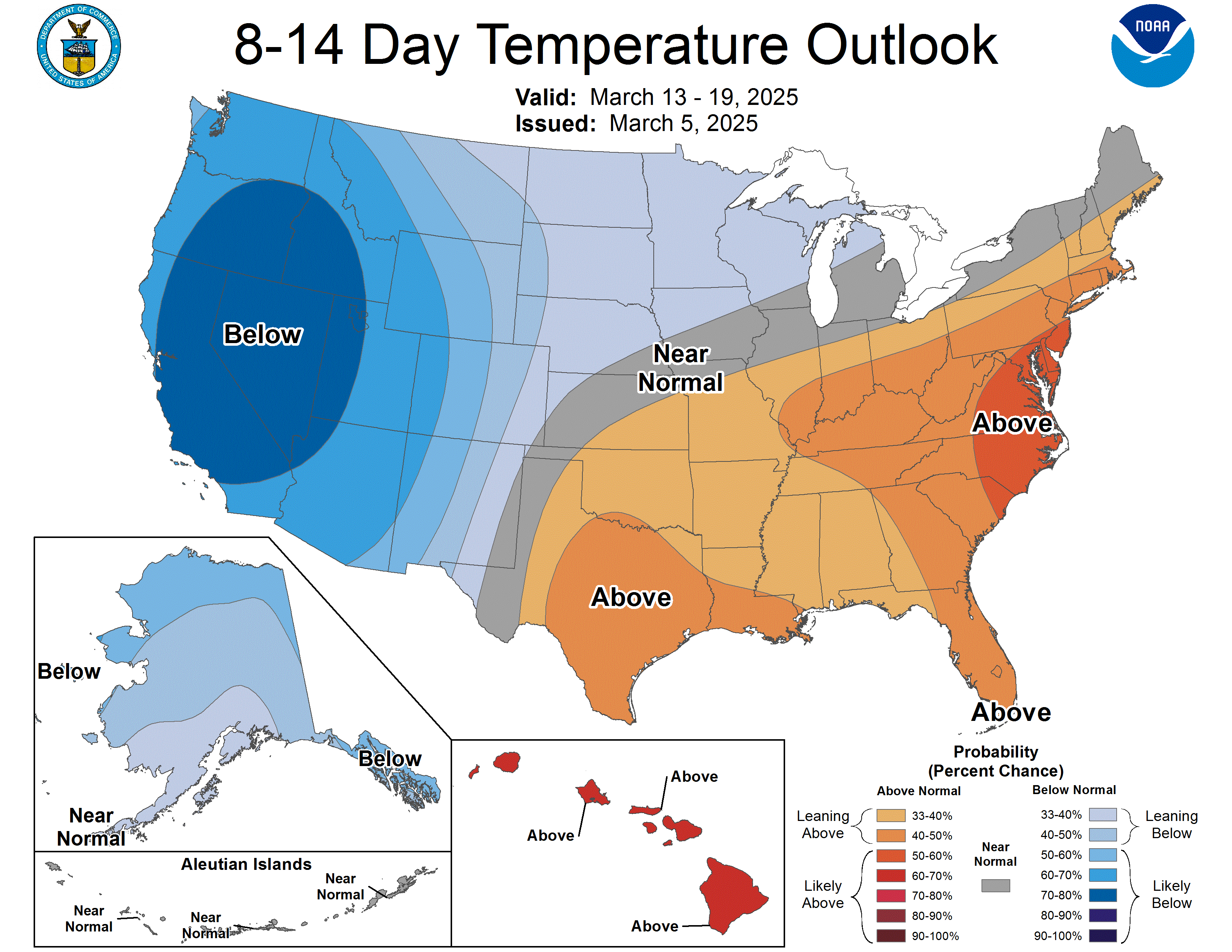
Looking Ahead
Through the evening of Monday, March 10, the National Weather Service Weather Prediction Center is forecasting parts of coastal and high elevation California, along with portions of the high elevation West to receive 0.75 or more inches of precipitation, though this is mostly expected to miss New Mexico, Montana, northern Idaho, Washington and Oregon. A few other corridors of at least a half inch of precipitation are forecast across northern Nebraska, from southeast Oklahoma to South Carolina and the Florida Panhandle, and in New England. Some areas of the Southeast may receive at least 1 inch of rainfall.
Looking ahead to March 11-15, the National Weather Service Climate Prediction Center forecast favors above-normal precipitation in the northern Contiguous U.S. and strongly favors above-normal precipitation in the western, and especially southwestern, U.S. Below-normal precipitation is favored in most of Texas, especially in far southern reaches of the state. Colder-than-normal temperatures are favored across the West, while warmer-than-normal weather is favored across most of the central and eastern Contiguous U.S.

Just for grins here’s a slideshow of early March US Drought Maps for the last several years.
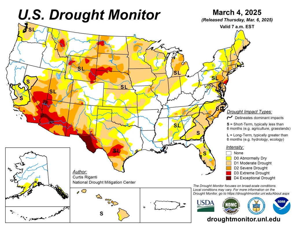
US Drought Monitor map March 4, 2025. 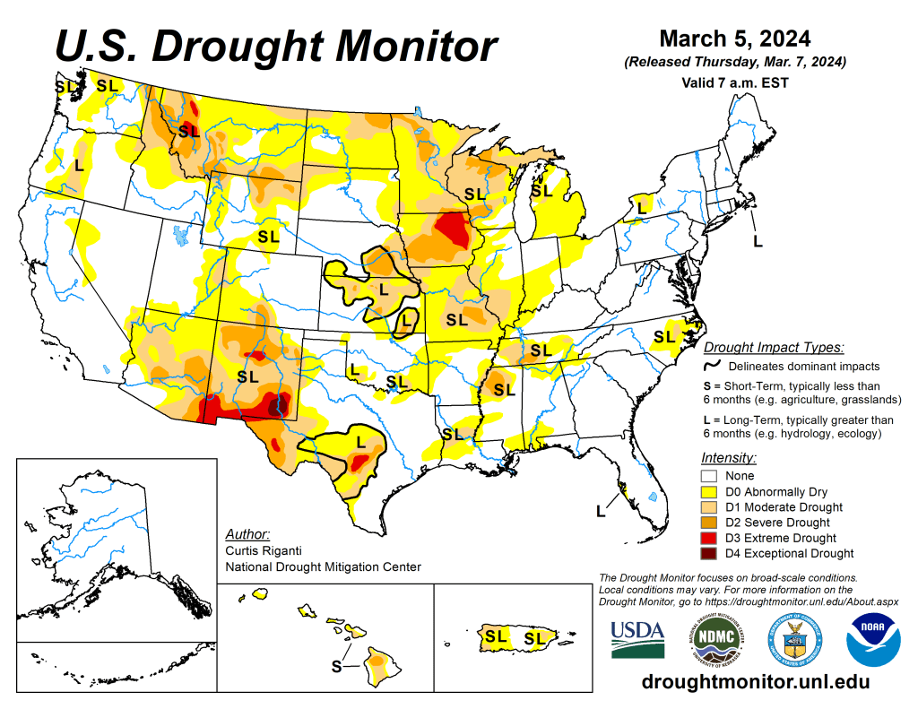
US Drought Monitor map March 5, 2024. 
US Drought Monitor March 7, 2023. 
US Drought Monitor map March 1, 2022. 
US Drought Monitor March 2, 2021. 
US Drought Monitor March 3, 2020. 
US Drought Monitor March 5, 2019. 
US Drought Monitor March 13, 2018. 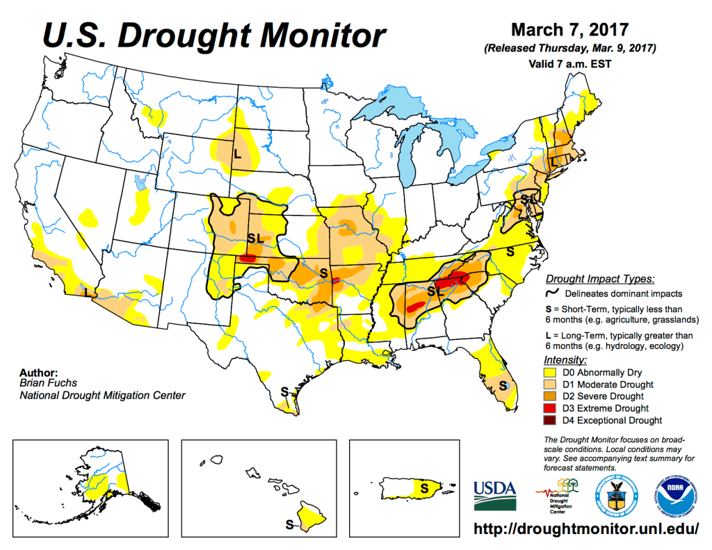
US Drought Monitor March 7 2017. 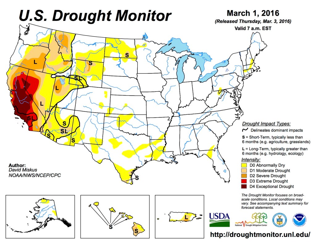
US Drought Monitor March 1, 2016. 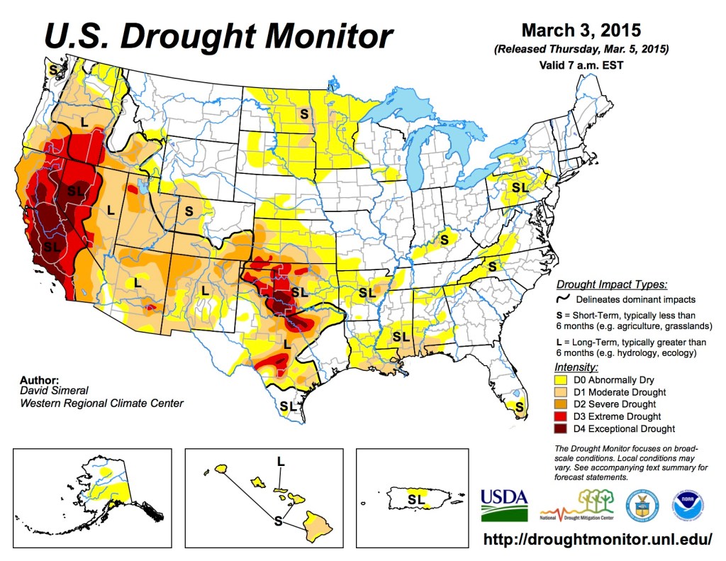
US Drought Monitor March 3, 2015 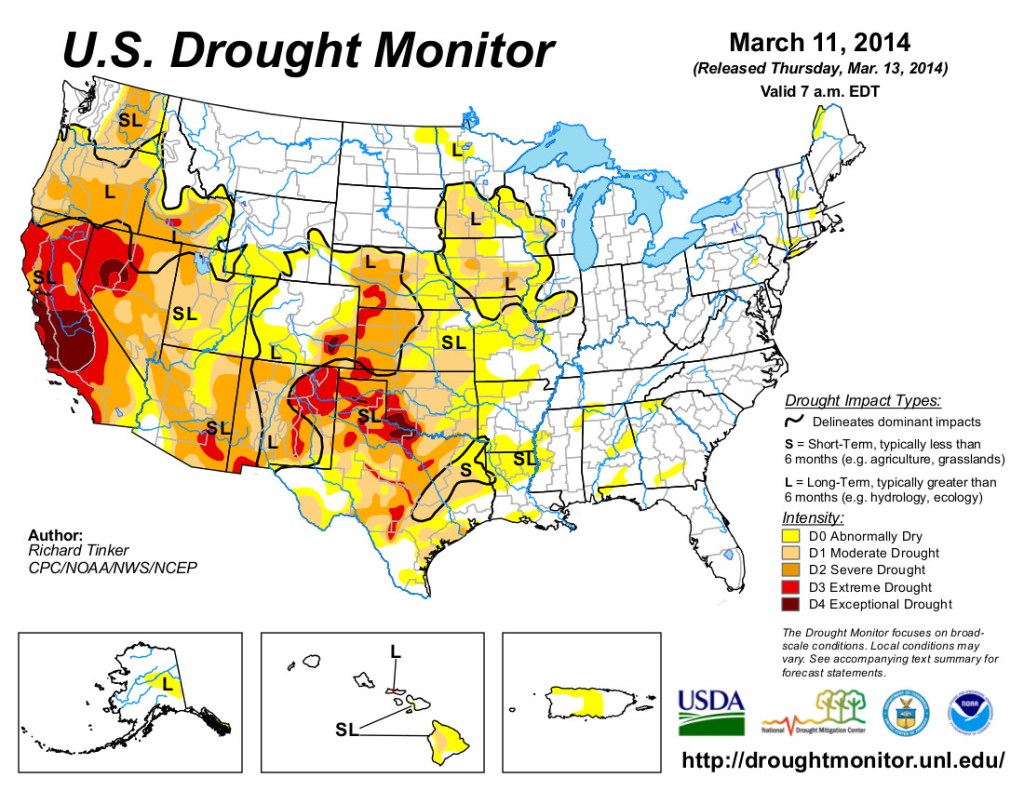
US Drought Monitor March 11, 2014 
US Drought Monitor March 12, 2013 
US Drought Monitor March 13, 2012 
US Drought Monitor March 6, 2009.