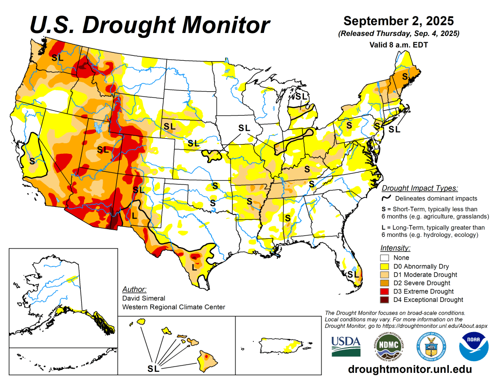
This U.S. Drought Monitor (USDM) week saw widespread degradation in drought-related conditions across areas of the Midwest, Mid-Atlantic, and Northeast where precipitation during the past 30-day period has been below normal. In these areas, rainfall deficits ranged from 3 to 5 inches with the largest deficits observed across areas of New England and Lower Midwest. Elsewhere, short-term dryness and drought impact reports from the agricultural sector led to degradations in isolated areas of the Southeast and South. For the week, most of the eastern half of the conterminous U.S. experienced unseasonably cooler temperatures, while temperatures out West were above normal, especially across the Pacific Northwest and Desert Southwest. In the West, conditions were generally dry, however, some isolated monsoon thunderstorm activity was observed in the Southwest, Sierra Nevada Range of California, Great Basin, and in the Rocky Mountains. In the Pacific Northwest, continued dryness as well as declining streamflow and soil moisture levels led to expansion of areas of exceptional drought in the Idaho Panhandle. In terms of reservoir storage in the West, California’s reservoirs continue to be at or above historical averages for the date (September 2), with the state’s two largest reservoirs, Lake Shasta and Lake Oroville, at 104% and 112% of average, respectively. In the Southwest, the U.S. Bureau of Reclamation is reporting (September 1) Lake Powell at 29% full (44% of average for the date), Lake Mead at 31% full (52%), and the total Colorado system (September 1) at 38% of capacity (compared to 44% of capacity the same time last year)…
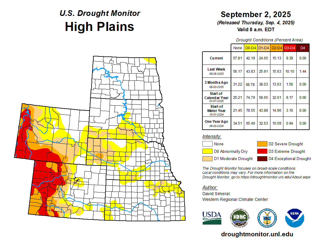
On this week’s map, improvements were made in the region, namely in northern Kansas, and southern Nebraska, where some isolated shower activity (1 to 5+ inches) during the past week continued to help chip away at the longer-term precipitation deficits. For the past 60-day period, the Lincoln AP observed its 6th wettest on record with 10.24 inches (+3.69 departure from normal), according to the SERCC. Conversely, conditions deteriorated on the map in the southwestern extent of South Dakota where a combination of short and long-term precipitation deficits have persisted leading to expansion of areas of Moderate Drought (D1). For the week, above-normal temperatures (ranging from 2 to 10 degrees F) were logged across northern North Dakota, while much of the remainder of the region experienced below normal temperatures (ranging from 1 to 10 degrees F), especially in the southern extent of the entire region…
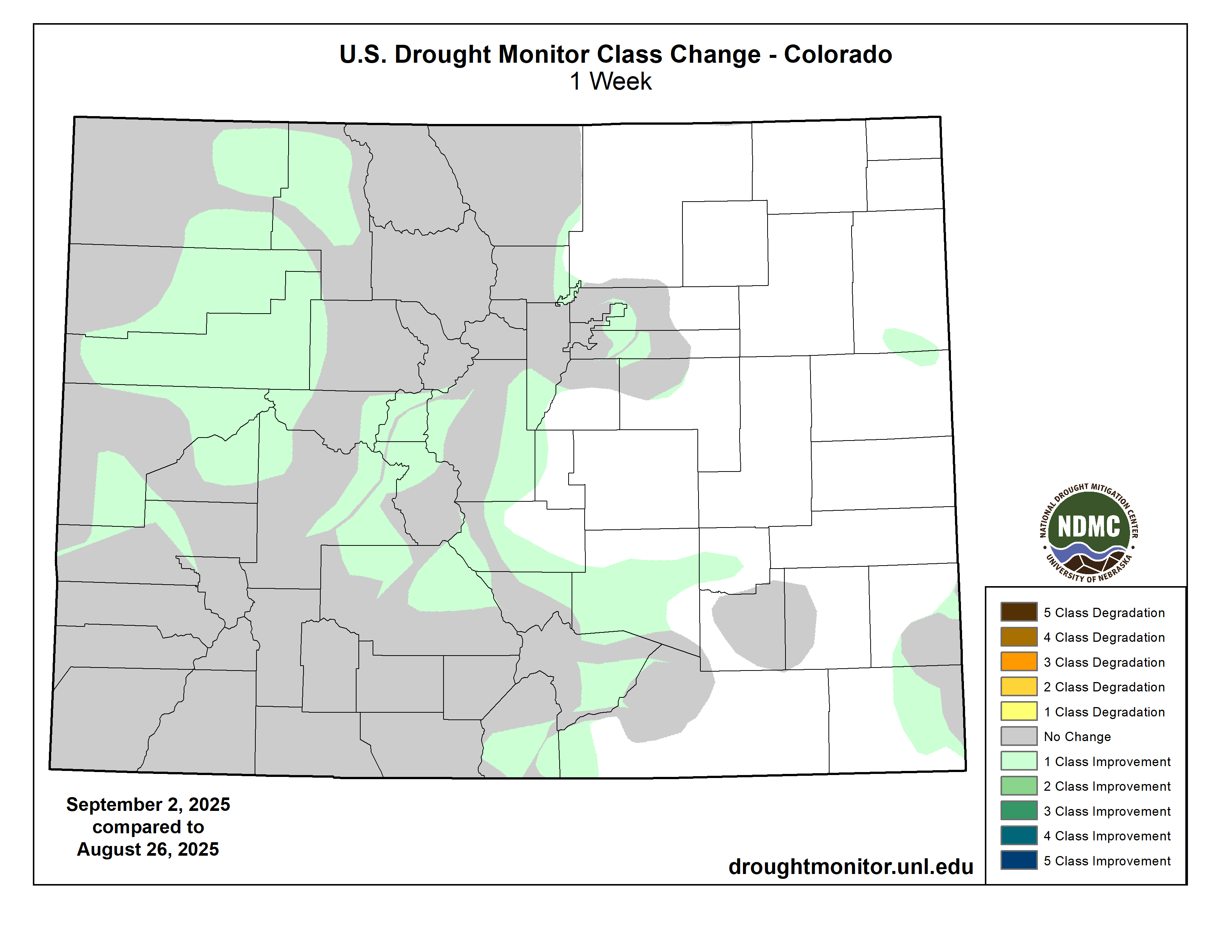
Colorado Drought Monitor one week change map ending September 2, 2025.
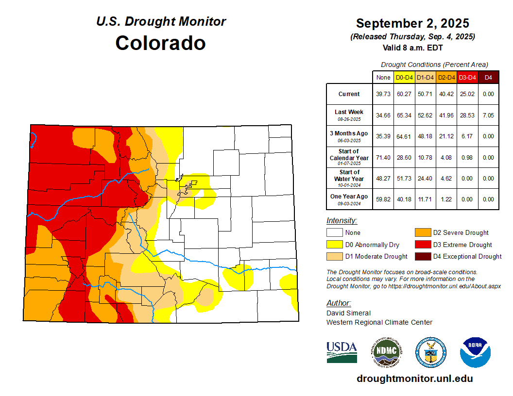
Out West, some isolated monsoon shower activity was observed across areas of the Desert Southwest, Sierra Nevada, and Great Basin as well as areas of the central and northern Rockies. Improvements were made on the map in Colorado, western Montana, southern Idaho, northern Utah, and southeastern California, while some degradations were made in north-central Arizona where monsoon-season precipitation has been below normal. According to the National Weather Service in Tucson, 2025 monsoon rainfall has been below normal across much of the state including Flagstaff, Phoenix, and Tucson. Conversely, a more active monsoon season has affected areas of New Mexico including southern and eastern portions of the state. For the week, average temperatures were below normal across areas of eastern California, central Great Basin, and areas of the Intermountain West including Utah, Colorado, and southern Wyoming where temperatures were 5 to 10 degrees below normal. In the Pacific Northwest, temperatures were above normal with anomalies ranging from 2 to 15 degrees F and the greatest departures observed in eastern Washington, Idaho Panhandle, and northwestern Montana…
On this week’s map, improvements were made in eastern Texas, northern Louisiana, northern Arkansas, and central Oklahoma in response to locally heavy rainfall (ranging from 2 to 6+ inches) observed during the past week. Elsewhere, short-term dryness led to introduction of areas of Abnormally Dry (D0) in areas of Texas including the Panhandle and Edwards Plateau. In Tennessee, degradations were made on the map in central and western portions in response to precipitation shortfalls (1 to 4 inches) during the past 30-day period. In terms of hydrologic conditions in Texas, the state’s reservoirs (cumulatively) were 77% full with many in the eastern part of the state in good condition (over 90% full), while numerous others in the western portion of the state continue to experience below-normal levels, according to Water Data for Texas (September 3). For the week, average temperatures were below normal (2 to 8 degrees F) across most of the region with the exception of southern and western portions of Texas where temperatures were 1 to 5 degrees above normal…
Looking Ahead
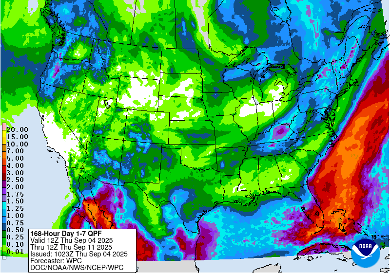
The NWS Weather Prediction Center (WPC) 7-Day Quantitative Precipitation Forecast (QPF) calls for moderate to heavy precipitation accumulations across areas of the Desert Southwest (southeastern Arizona) in association with remnant moisture from Hurricane Lorena. Additionally, heavy rainfall is expected in southern Florida, while light-to-moderate accumulations are expected across areas of the Pacific Northwest, Rockies, Texas, Lower Midwest, and Northeast. The Climate Prediction Center (CPC) 6-10-day outlooks call for a moderate-to-high probability of above-normal temperatures across most of the West, Central and Northern Plains, and Gulf Coast region. Conversely, below-normal temperatures are forecasted for the Midwest, Mid-Atlantic, Northeast, and areas of eastern California and western Great Basin. In terms of precipitation, there is a low-to-moderate probability of above-normal precipitation across most of the conterminous U.S. with exception of areas of the Southwest, Upper Midwest, and New England in proximity to the Great Lakes and Canadian border where below-normal precipitation is expected.
US Drought Monitor one week change map ending September 2, 2025.
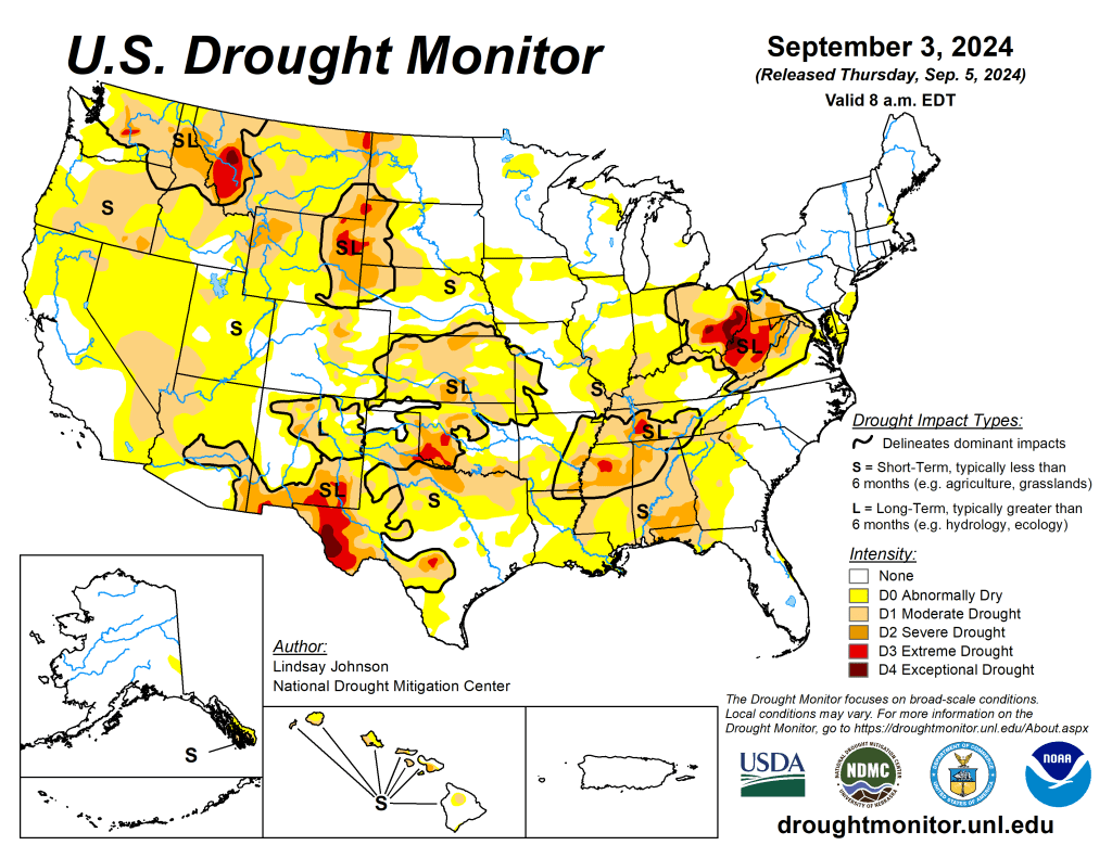
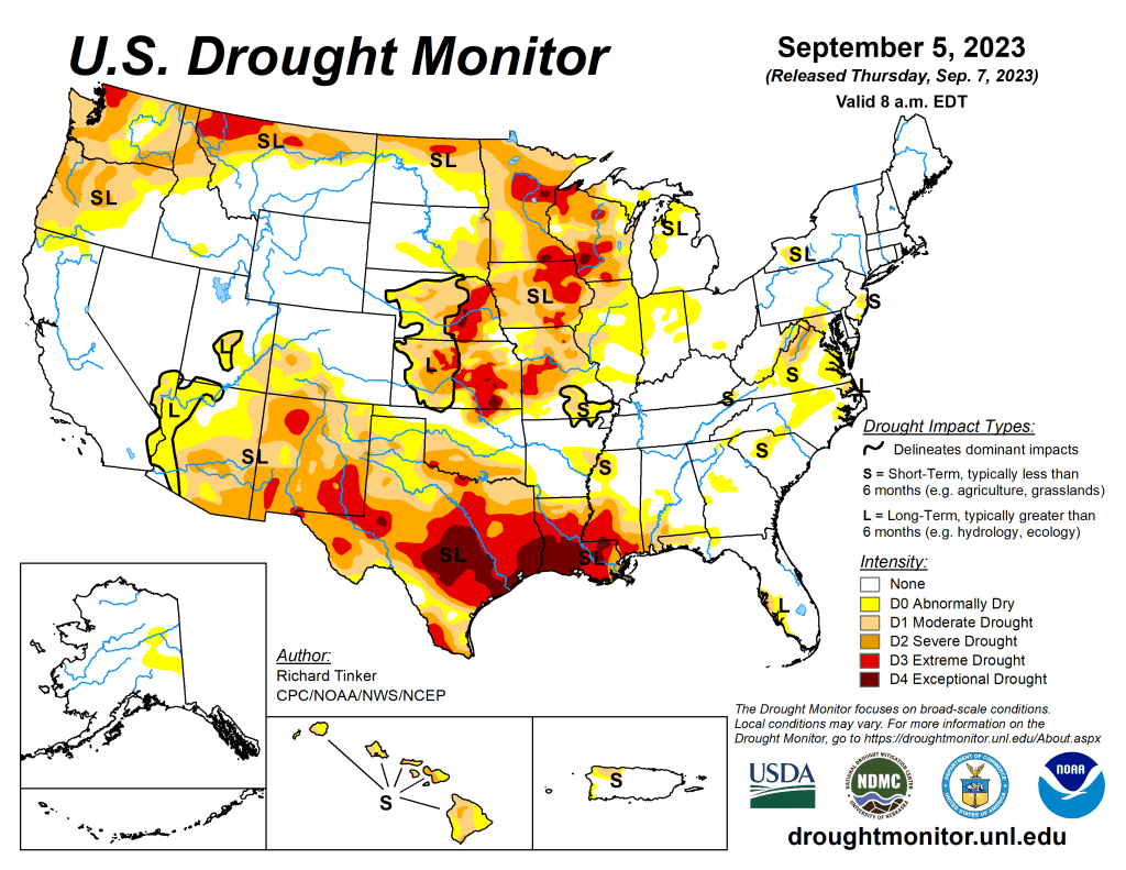
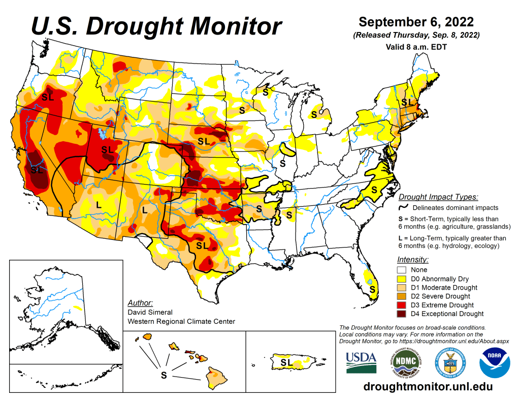
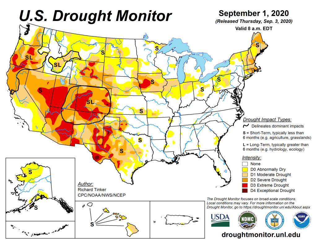
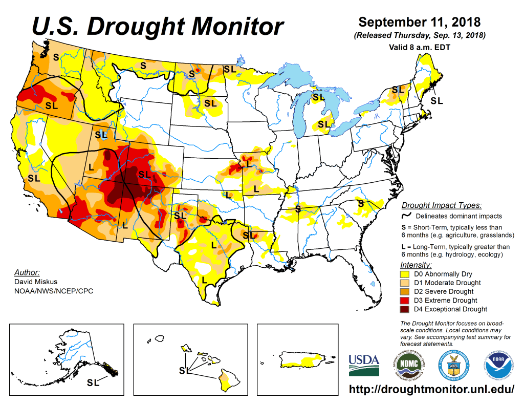
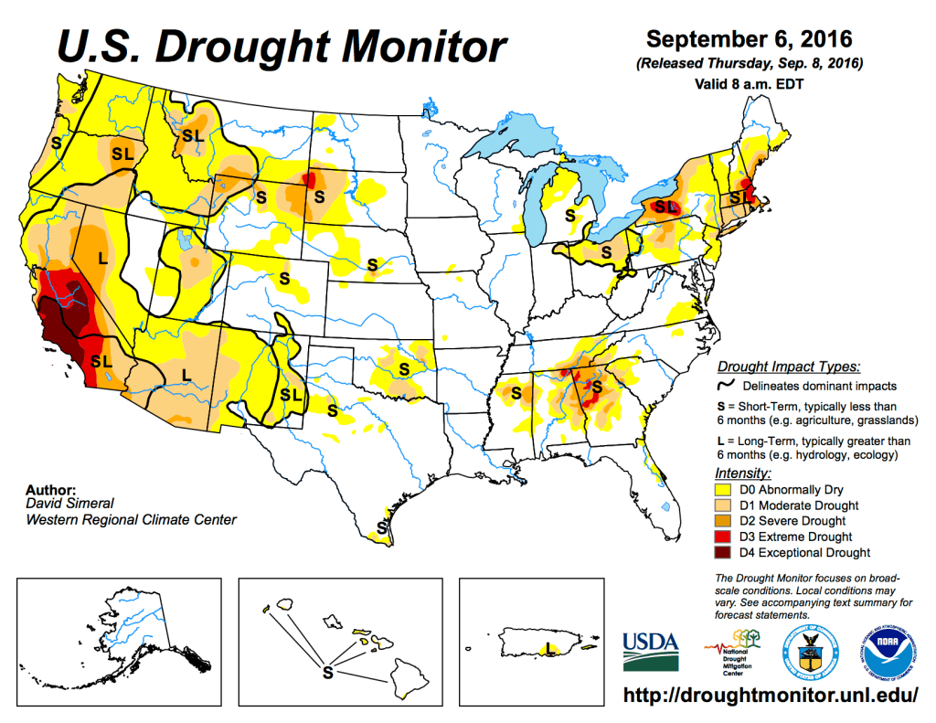
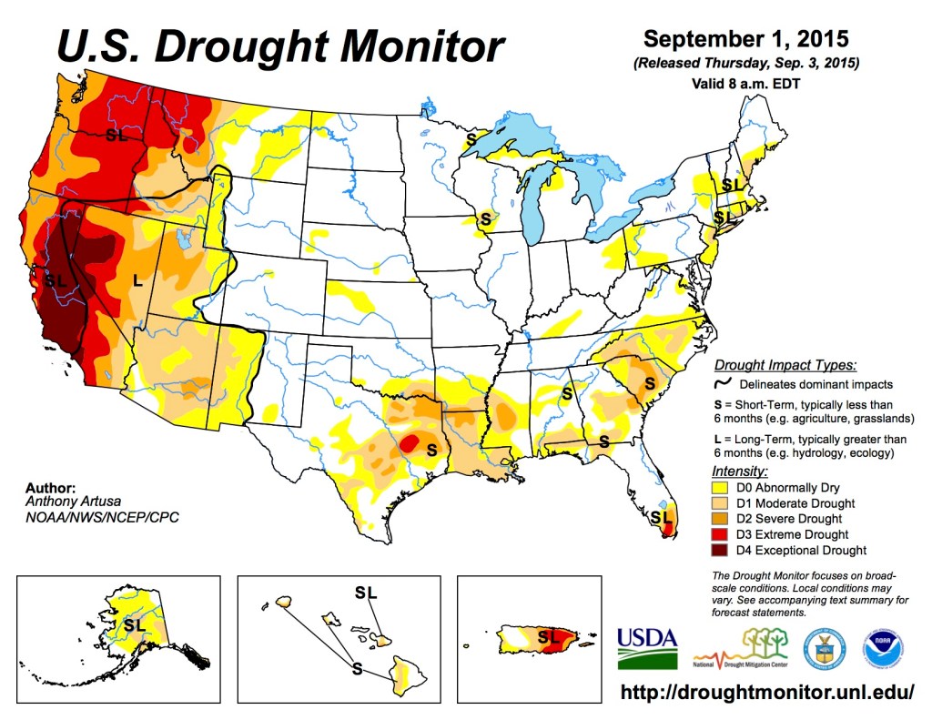
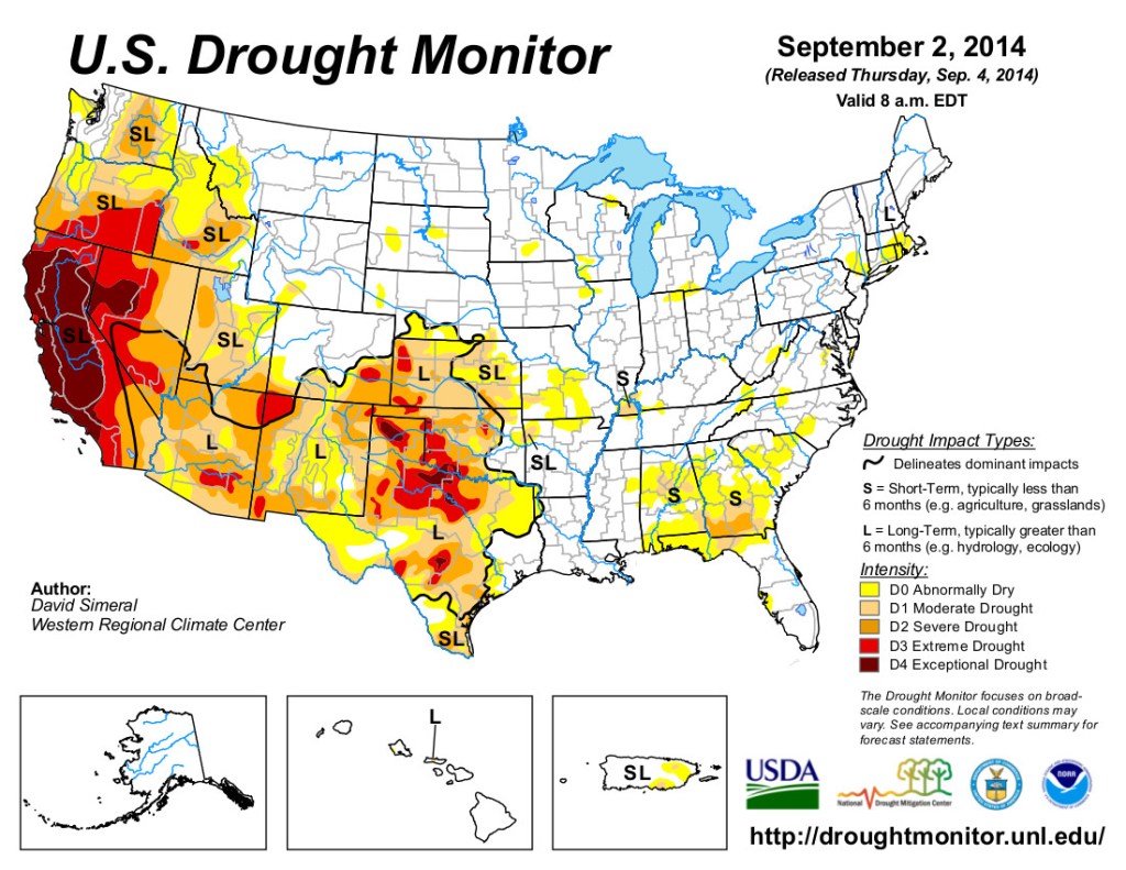
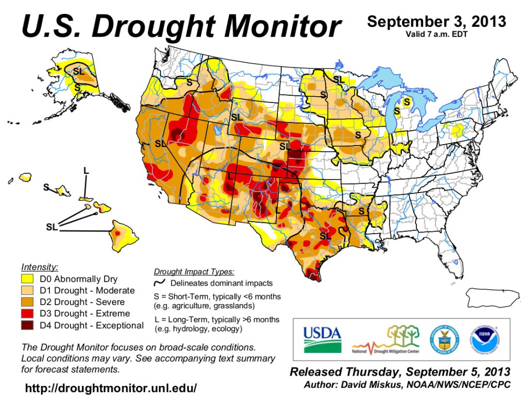
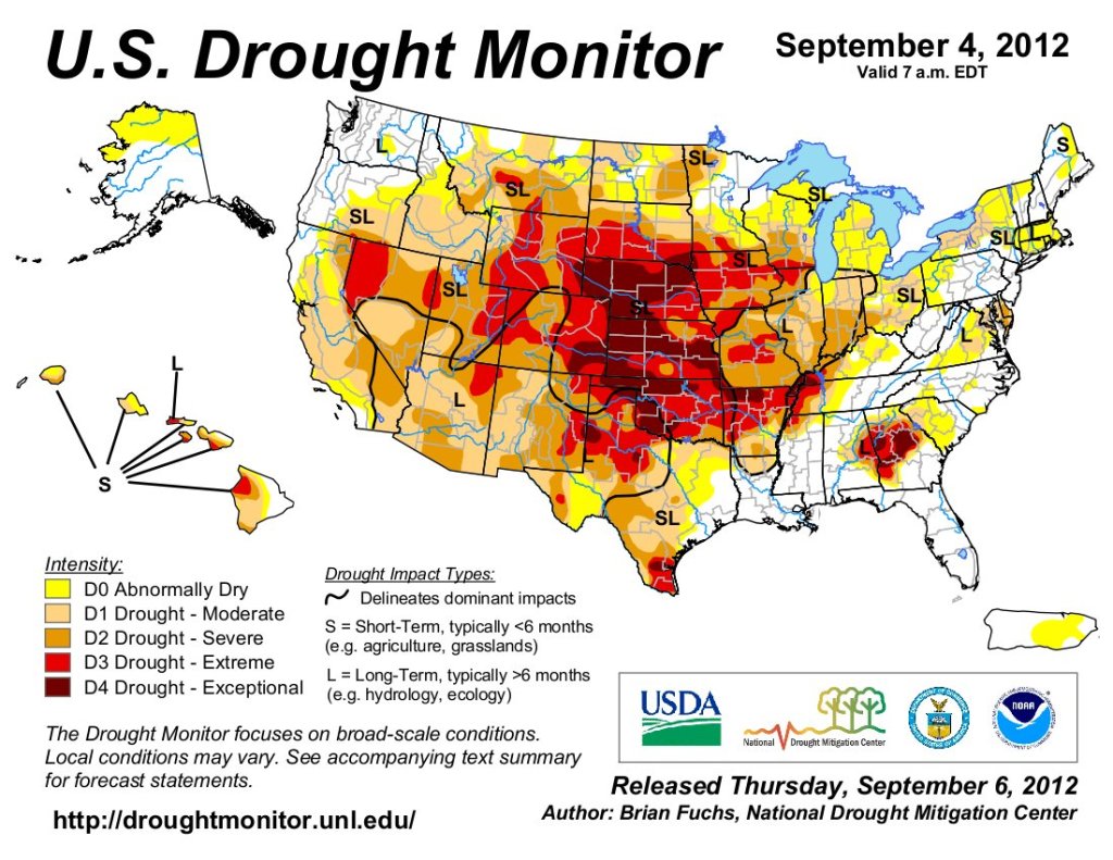
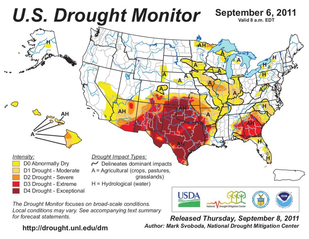
Just for grins, here’s a slideshow of US Drought Monitor maps for early September for the last few years.
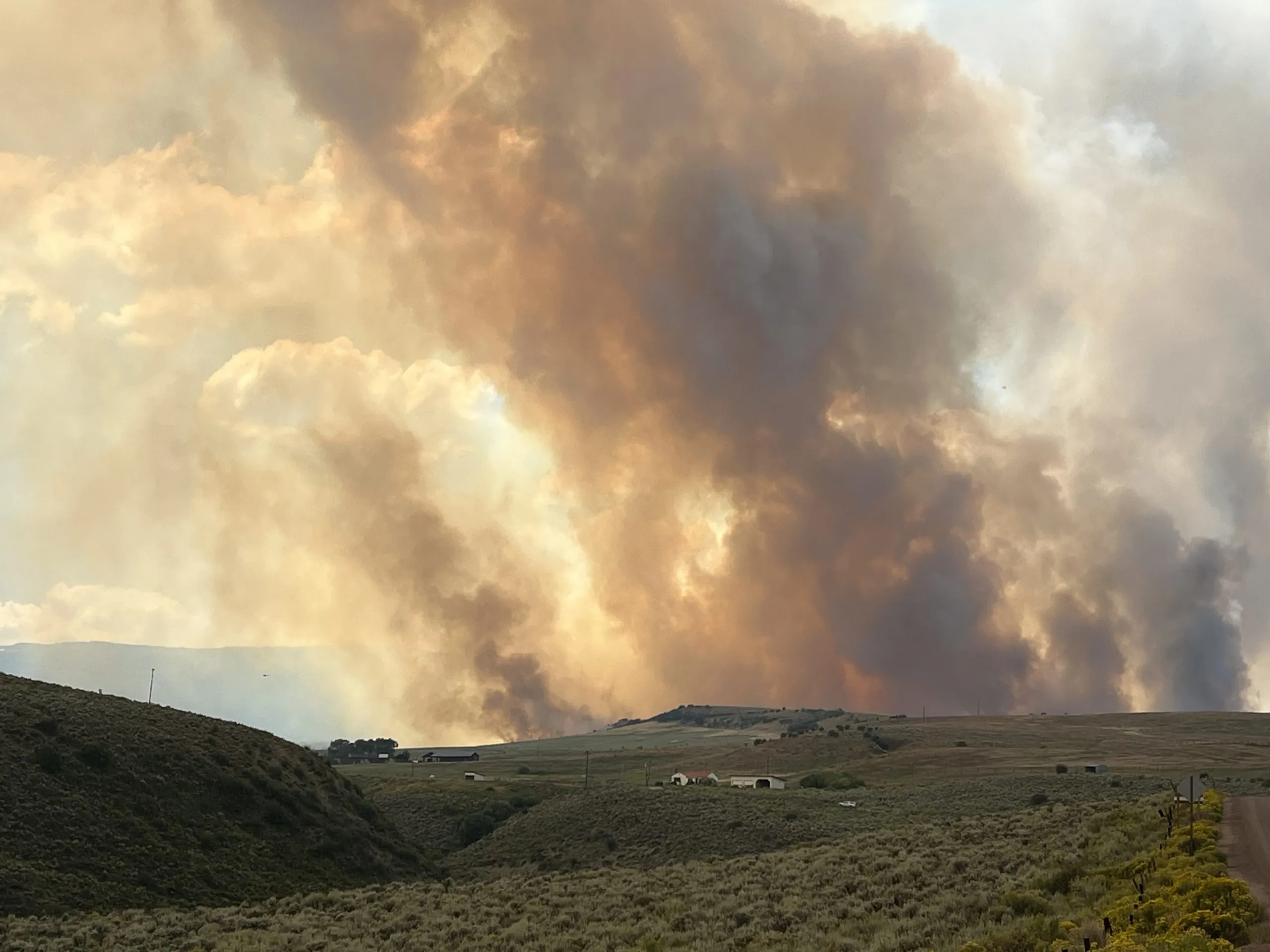
Every element that a wildfire needs in order to burn big, hot and fast converged in the northwestern corner of Colorado in early August.
Persistent daytime temperatures neared record highs. Winds gusted at 40 mph. Humidity levels hovered at about 2% — a percentage typically only seen in the Mojave Desert, said fire-behavior analyst Béla Harrington.
After six months of scant precipitation, the soil and vegetative fuels were bone dry, ready to explode with any extraneous spark.
The hot, thirsty air had sucked nearly every bit of remaining moisture out of the grasses, shrubs and trees.
With extremely low fuel moisture content levels in all types of vegetation, “The live fuels act like dead fuels,” Harrington said.
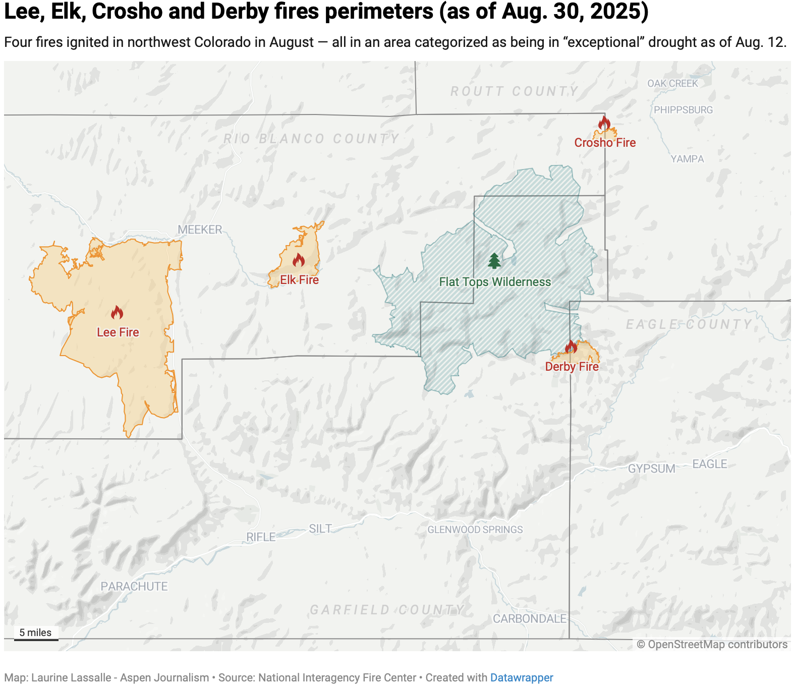
Between Aug. 6 and 9, the Lee and Elk fires near the town of Meeker scorched more than 100,000 acres.
By the time it was 95% contained on Aug. 31, the Lee Fire had become the state’s fourth largest fire in recorded history, with 138,844 acres burned.
“It’s the drought,” Harrington said from the Incident Command Center on Aug. 18 in Meeker, referring to why the Lee fire grew so big and so fast. At one point, the fire jumped across Highway 13 and came within less than 2 miles of the western edge of the town.
Had it not been for a change in wind direction that shifted the fire’s fury south toward Rifle — combined with the federal deployment of a massive amount of firefighting resources — the town may have faced a full evacuation.
On Aug. 11, the day before the larger region officially entered “exceptional drought” conditions, the Crosho fire started about 40 miles east of Meeker across the Flat Tops Wilderness, threatening the town of Yampa and ultimately burning more than 2,000 acres before it was declared fully contained Aug. 26.
Less than 30 miles to the south of the Crosho fire, lightning on Aug. 19 ignited the Derby fire on steep forested terrain, burning more than 5,700 acres near Dotsero.
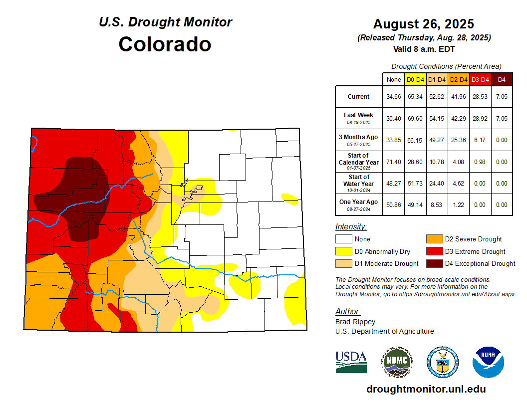
Colorado’s only current area of D4 drought — the highest designation on the U.S. Drought Monitor’s 0-4 scale — encompasses the footprints of the four fires as well as nearly all of Garfield County, much of Rio Blanco County, and pieces of Moffatt, Routt, Eagle, Pitkin, Gunnison, Delta and Mesa counties.
The drought map of Colorado as of Aug. 28. Exceptional drought — the most extreme category — has fueled wildfires in the northwest region of the state.
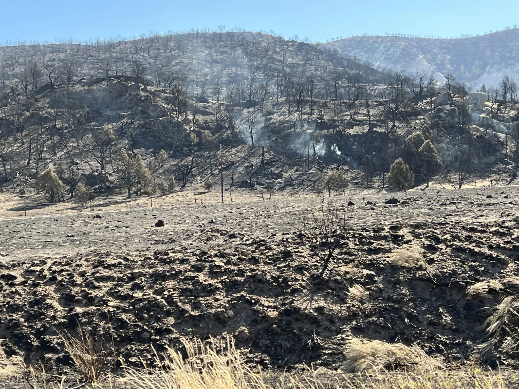
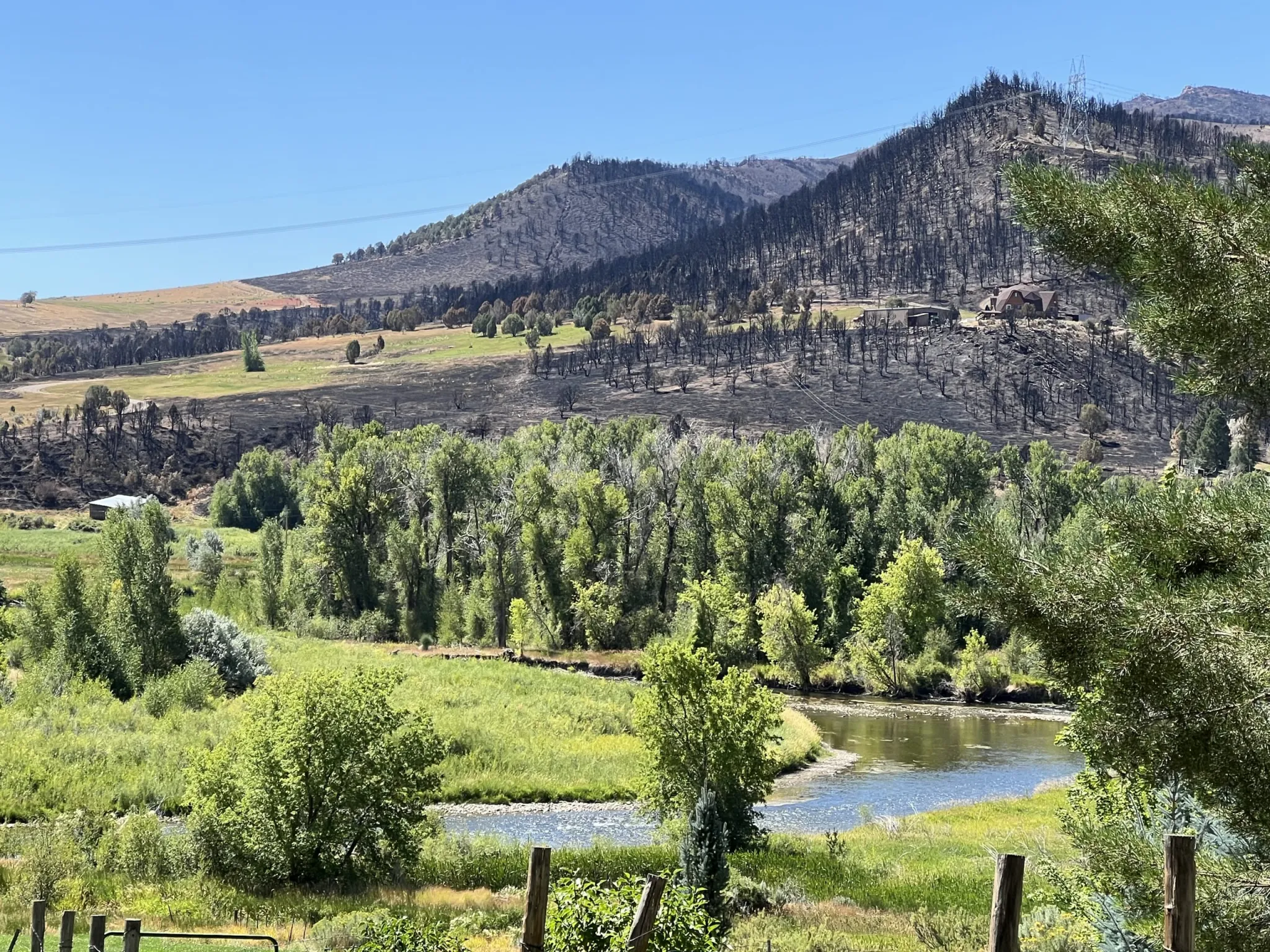
Over much of the region, the soil is parched, the grass is yellow and wilted leaves are already changing colors.
From Meeker, Harrington pointed to red, orange and yellow serviceberry bushes on the hillside. “That doesn’t usually happen until October,” he said.
The monsoon season, which typically brings precipitation to the region starting in mid-July, didn’t show up until the end of August, said Colorado State climatologist Russ Schumacher. Before the season’s arrival this year, there were hot days, little cloud cover and very low humidity.
Mary Flynn, a fire prevention officer with the White River National Forest, said early color changes usually signal tree stress. Trees and shrubs in the region are going into winter dormancy early because of the drought, she said.
“With prolonged drought, trees are forced to conserve energy and resources. Lack of water will halt chlorophyll production and trigger leaf shedding to conserve water,” she said. “When a forest becomes severely impacted by drought, the small diameter plants, branches and grasses catch fire easily. Once the small diameter fuels are burning, fire spreads quickly to larger dry branches and plants. Once a fire is established, the resulting heat causes fire to spread even more quickly.”
In John Vaillant’s book “Fire Weather, he writes, “The drier the fuel and the hotter the air, the more explosive the fires, the more intensely they burn, the harder they are to extinguish and the more likely they are to produce their own weather in the form of wind and pyrocumulus clouds, which can generate fire whirls, tornadoes and more lightning, resulting in yet more fires that will perpetuate themselves for as long as fuel and weather conditions allow.”
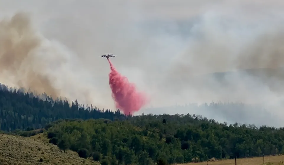
On Aug. 9, the Lee fire created its own weather system, reaching above 30,000 feet with a pyrocumulus cloud.
The Lee fire’s smoke cloud was so big, it shaded the nearby Elk fire, Harrington said, cooling the smaller fire and giving firefighters an advantage. Burning along the White River just east of the Lee fire, the Elk fire was fully contained Aug. 16 at 14,518 acres.
A D4 drought is expected about once in 50 years, said Schumacher. “It’s reserved for the most extreme drought conditions,” he said.
But parts of Colorado have entered into exceptional drought at least five times since 2000.
“Based on tree-ring analysis, it has been determined that the American West is currently in the most severe drought of the past 1,200 years,” Vaillant writes in “Fire Weather.”
“Climate change is expected to continue to exacerbate impacts to forested ecosystems by increasing the frequency, size and severity of wildfires across the western United States,” according to a 2023 study by Tzeidle Wasserman and Stephanie Mueller and published in Fire Ecology.
And the trends are by no means isolated to the American West.
Canada set records in 2023 for its worst fire season and is currently experiencing its second-worst fire season in recorded history.
The European Union is experiencing its worst wildfire season on record.
National Interagency Fire Center public information officer Eric Coulter describes the fast moving progression of the Lee Fire in early August. CREDIT: KARI DEQUINE/ASPEN JOURNALISM
Good fire versus bad fire
Decades of excluding fire from the landscape inadvertently led to a mass buildup of fuel, said Angie Davlyn, executive director of the Roaring Fork Valley Wildfire Collaborative. Today, land managers are “doing great things to bring fire back in safe ways,” she said. However, Davlyn described this season’s drought conditions, when combined with the amount of “flammable stuff ready to ignite,” as “scary.”
Fire needs to be an essential part of the ecosystem, said Harrington. Some species of vegetation actually require heat in order to regenerate. Fire clears debris to make way for healthy new growth. “But you want low-intensity fire,” he said.
Schumacher said: “In the big picture, what we probably need is more fire on the landscape than less. But what we don’t want is really fast-growing, really intense fires. For one, they tend to be really hard to fight and raise the chance of approaching towns like Meeker or Rifle.”
Ecosystem recovery can also look different with higher-intensity fires, he said.
“When fires burn so hot and so intensely, they are not as healthy to the vegetation cycle regrowth,” he said. “When vegetation is scorched so completely, it takes a lot longer to come back,” and that creates conditions for invasive species such as fire-prone cheatgrass to infiltrate. “A really hot, intense, fast-moving fire can alter the ecosystem. That’s the difference.”
Fire severity — which is the extent of damage to vegetation and soil — is determined after a fire and plays a key role in recovery.
Drought can play a significant role in how fires affect ecosystems, according to a 2024 NASA analysis of 1,500 fires from 2014 to 2020 across the West. The research showed that “forests, grasslands and scrublands all struggle to recover from droughts that occur close in time with high-severity fires, which are becoming more common in the West,” writes Emily DeMarco, who is with NASA’s Earth Sciences Division. “That can lead to potentially lasting changes not only in the plant communities but also in local and regional water dynamics.”
Schumacher noted the increased fire risk after wetter years, when vegetation flourishes and grows dense.
“If it is dry, dry, dry all the time, the fuel never builds up, so you don’t have a lot of stuff to burn,” he said. “The amplification of extremes is a pretty common theme in what we can expect with a warmer climate.”
He also noted how wildfire burn scars increase the risk of flash flooding and mudslides, with vegetation killed and the topsoil layer turned hydrophobic, meaning it can’t absorb water. Schumacher pointed to the postfire mudslides that closed Interstate 70 in Glenwood Canyon the year after 2020’s Grizzly Creek fire, and deadly floods near Fort Collins two years after the Cameron Peak fire in 2020.
On July 8 in Ruidoso, New Mexico, destructive and deadly flash floods swept through the town that had been devastated by two wildfires in 2024.
The late-August rains prompted flash-flood warnings near the Lee fire with mudslides reported in Rio Blanco County. Although some area roads were impacted, no damage or injuries were reported.
Harrington said he had hope for renewed fertile pastures and healthy forage for deer and elk in at least some of the Lee fire’s footprint.
The Lee Fire smolders along Highway 13 south of Meeker on Aug. 18. The highway reopened on Aug. 16. CREDIT: KARI DEQUINE/ASPEN JOURNALISM
Bigger fires, longer seasons
A sign in Moffat County commemorates the 1988 “I Do” fire, which burned 15,000 acres and became, at that point, the state’s largest recorded fire.
The brutal fire season of 2002 brought many larger fires, including the Hayman fire, which became the largest ever in Colorado, at 137,760 acres. Then, in a single drought-fueled fire season in 2020, the Hayman was pushed to fourth place by the Cameron Peak fire (208,913 acres), the East Troublesome fire (193,812 acres) and the Pine Gulch fire (139,007 acres).
“Fire has always been a part of the landscape in the Western U.S.,” Schumacher said. “But these really big destructive fires are a relatively new phenomenon in western Colorado.”
Firefighter helicopter pilot and Basalt resident Steve Cohen said that in his 25-year career, he has seen firsthand fires steadily increasing in size. It wasn’t that long ago, he said, that “we’d never heard of a 100,000-acre fire.”
Cohen worked on the Lee, Elk and Crosho fires. Flying a six-seater A-Star helicopter, his duties include scoping out reports of smoke and transporting firefighters into and out of precarious terrain. Once he drops the crews, he takes the helicopter door off and sets up his neoprene bucket hanging at the end of a 100- to 150-foot cable, designed to scoop water from nearby ponds and lakes before dumping it on a fire.
Cohen also noted that many helicopter pilots are now required to work year-round contracts for what used to be a summer job. Thankfully grandfathered into his seasonal role, Cohen works as a ski patroller on Aspen Mountain in the winter.
A large aircraft drops retardant onto the edge of the Crosho Fire on Aug. 13 as it nears homes along County Road 8 near Dunkley Pass. CREDIT: KARI DEQUINE/ASPEN JOURNALISM
Firefighters save the day
While towns, surrounding neighborhoods and ranches were largely spared the wrath of the four northwestern Colorado fires, the Lee fire destroyed 30 structures, as well as an unknown number of cattle that could not be evacuated in time. According to the incident response team, seven of the structures were homes or cabins and 23 were “outbuildings.” Oil-and-gas infrastructure is still being evaluated for damage.
Eight structures were lost to the Elk fire, no structure was lost to the Crosho fire and one structure has been destroyed in the Derby fire, which was 6% contained as of Aug. 31.
The containment efforts by fire crews benefited significantly from the proximity of the fires to one another. When the Crosho and Derby fires ignited, abundant resources were already staged nearby, said Caleb Ashby, a Bureau of Land Management public affairs specialist with the National Interagency Fire Center (NIFC).
Crews worked on the Lee fire round the clock — bringing in a large amount of federal resources also protecting critical oil-and-gas infrastructure located near the fire’s northwestern boundary, said Eric Coulter, a NIFC public information officer.
At the Lee fire’s peak, there were nearly 1,300 inhabitants of the Incident Command Center staged at the Rio Blanco Fairgrounds in Meeker.
They utilized the most drones on any fire to date, Coulter said, including aircraft equipped with small “ping pong” balls filled with a chemical powder and then injected with glycol upon release, giving crews an aerial and overnight option to fight fire with fire in order to destroy fuel in the path of the fire and slow and control the burn.
At the Crosho fire, the federal response was immediate, and the air show was impressive. Not long after smoke was first reported, four red and yellow “Super Scooper” planes skimmed the surface of nearby Stagecoach Reservoir, filling their massive bellies before emptying them onto the fire.
Additional aircraft dropped countless loads of bright-pink retardant on the fire’s edges, while several different types of helicopters dumped water. Another plane flew high overhead, coordinating the whole show with military precision.
On Aug. 14, Colorado Gov. Jared Polis declared a disaster emergency and authorized the National Guard to help with the fire response, primarily utilized on the larger Lee and Elk Fires.
Rain fell on the Lee and Crosho fires on Aug. 15, helping turn the corner.
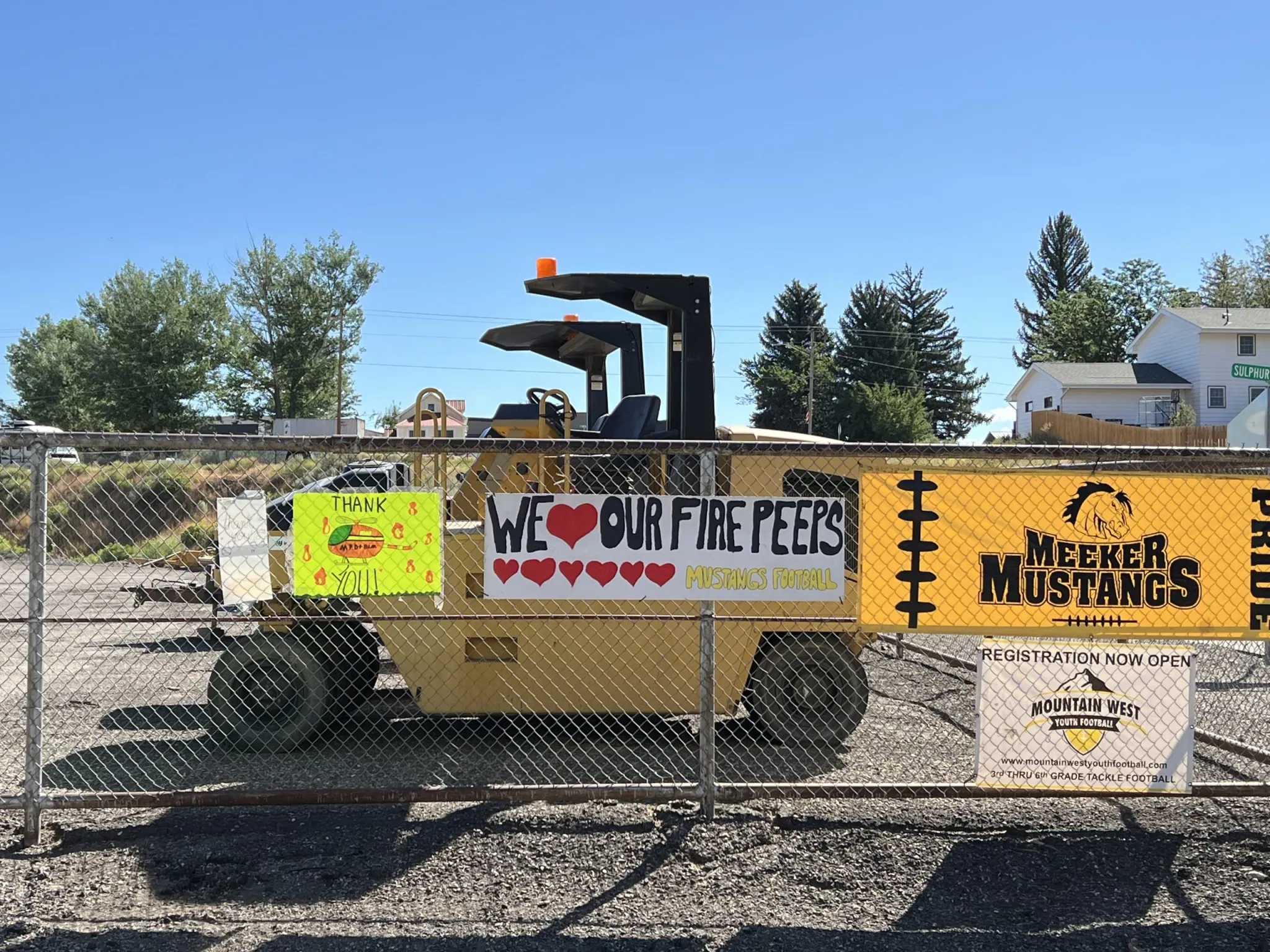
In communities near the four fires, handmade signs hung on fences and buildings expressing gratitude to the firefighters. Without the fast and massive local and federal responses — and lucky weather breaks — outcomes could have undoubtedly been worse.
Handmade signs of thanks cover the fence around the Rio Blanco County Fairgrounds — the temporary staging ground for the Lee and Elk fires’ incident command center. CREDIT: KARI DEQUINE/ASPEN JOURNALISM
Limited resources
The United States is currently at a Preparedness Level 4 (PL4), indicating that “national resources are heavily committed,” according to the NIFC.
A PL5 — the highest level — indicates “national resources are heavily committed, and additional measures are taken to support geographic areas. Active geographic areas must take emergency measures to sustain incident operations.”
At a PL5, it is possible that fire-response teams can’t get the resources that they request, Ashby said, although, ideally, resources are available but need to be moved around more strategically with a focus on protecting “values.”
“It is extremely impressive how fast we can move resources across the country to the folks who need them,” he said.
Still, “If we are at a PL5, resources are stretched extremely thin,” Ashby said. “Everyone is competing for the same resources.”
The values prioritized for protection include life, property, critical infrastructure and natural resources, Ashby said. With the critical fire weather conditions on display through most of August, the focus is on the initial attack.
“If we can keep a fire small before it grows into a large fire, that saves a lot of resources,” he said.
Collectively, the four fires surrounding the Flat Tops have cost the federal government about $65 million to fight, according to the most recent Incident Management Situation Reports.
The Lee fire alone has a price tag of $29.1 million as of Aug. 31. And that has not even been the state’s most expensive fire. The Turner Gulch fire, in Mesa County, has an estimated cost of $39.8 million to the federal government as of Aug. 28.
Ashby noted that these costs are just estimates at this time. Full costs include suppression repair, rehabilitation and local reimbursements, and they are not fully borne out until long after a fire has been extinguished.
On Aug. 6 and 7 the Lee Fire jumped across Highway 13, encroaching over the “Hogback” less than two miles from the edge of the town of Meeker. CREDIT: KARI DEQUINE/ASPEN JOURNALISM
The forecast
As fortuitous days of rain — heavy at times — fell on all four fires during the final week of August, it appeared that Mother Nature decided that the extremely drought-stricken corner of Colorado had had enough fire, for now.
The double-edged sword of precipitation also brought lightning and numerous new fire starts in the region, all of which were quickly contained.
Schumacher said he sees drought and fire comparisons to 2020, although he noted that the state’s second-biggest fire on record — East Troublesome — was ignited Oct. 14 of that year.
“2020 was exceptional in how long fire conditions persisted,” he said. “It remains to be seen if we have fires continue into the fall.”
At this time, the forecast is tilted toward a warmer-than-average fall, Schumacher said.
“The key question now is: Are we going to get relief here later in August and September, and see the end of fire season at that point? Or will we go back to a warm and dry fall and see things happening later in the season like 2020?”
Globally, 2025 is on track to become the second or third hottest year on record, behind 2024 and 2023.
Although there is only so much that humans can do in the face of bigger, hotter and faster fires, approximately 85% of wildfires nationwide are human-caused, according to the NIFC.
Davlyn said about half of Colorado’s annual average of 2,500 wildfires are caused by lightning.
Human-caused fires take resources away from lightning-caused fires, said Ashby. And although the late-August rains tempered the four fires and brought a collective sigh of relief from surrounding communities, “It’s not going to end this drought,” Davlyn said. “It’s not going to rehabilitate trees that have been in critical condition for months. It doesn’t work that instantaneously.”
Flynn echoed the need for continued vigilance. “This week’s moisture is providing much-needed relief on dry, stressed fuels in western Colorado,” she said. “But it may not be enough to significantly reduce fire danger moving into the fall.”
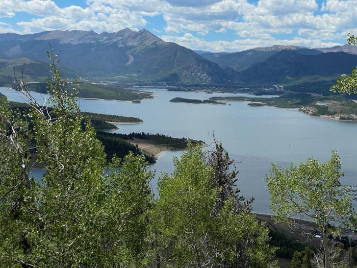
Up until late August, this summer has been particularly dry, both for the Denver region and for the West Slope, the source of half of Denver Water’s supply. And that combination has translated into a heavy workload for the utility’s largest reservoir, the 257,000-acre-foot Dillon Reservoir in Summit County.
Dillon Reservoir in Summit County is Denver Water’s largest reservoir. Photo credit: Denver Water.
A summer largely bereft of the monsoon rains (which bolster our water supply and reduce water use by our water-smart customers) combined with long stretches of days above 90 degrees pushed up demand among the 1.5 million people Denver Water serves.
The dry summer situation also triggered calls for more water from farmers and ranchers who have senior water rights that put them at the front of the line for receiving water from the South Platte River system. Denver Water’s supplies are also constrained on the north side of its system, as ongoing work on the Gross Reservoir Expansion Project requires the utility reduce the amount of water it stores in that reservoir during the project.
Dillon Reservoir provides Denver Water with a supplemental supply to use when the amount of water available from its south system source, the South Platte River, is not enough to meet demands.
That all combined to make Denver Water more heavily reliant on Dillon Reservoir than usual, forcing the utility to push higher volumes from Dillon through the Roberts Tunnel to the Front Range.
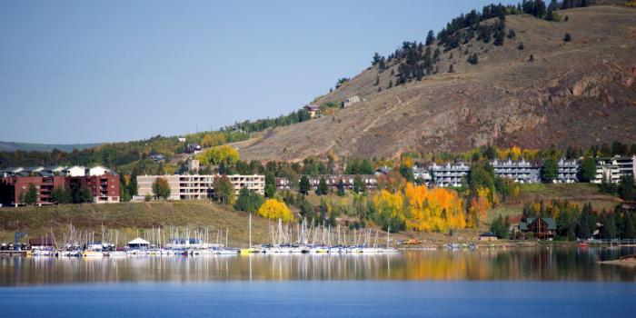
“A lot of factors combined to see us lean hard into our Dillon supplies this summer,” said Nathan Elder, manager of supply for Denver Water. “We know this impacts recreation, both what we release into the Blue River below the reservoir and the water levels for the marinas at Dillon Reservoir. We try very hard to maintain good conditions for recreation at Dillon, but this summer posed challenges.”
The Dillon Marina at Dillon Reservoir. Photo credit: Denver Water.
Overall, the amount of water flowing into Dillon was at just 70% of normal in the April-through-July stretch. July alone saw just 48% of typical flows into the reservoir — that’s 20,000 acre-feet below average, about the capacity of Antero Reservoir west of Fairplay.
The situation serves as a reminder for Denver Water customers to stay smart about water use.
Especially amid a hot, dry summer, customers should make sure to follow watering rules and skip irrigation during rainy periods. And they should consider landscape changes that replace thirsty turfgrass with plants that need less water.
Yet, despite relentless dry periods covering July and most of August, Denver Water customers did a good job managing irrigation. They used water at a rate of just about 2% above the five-year average, and just 1.6% above the longer term, 2000-2024 average.
These plants from Resource Central’s Garden In A Box program are water-wise and interesting throughout the year. Photo credit: Denver Water.
But even as Denver Water customers kept demands low by historical standards, the combination of conditions saw water levels in Dillon fall below levels optimal for the marinas at the reservoir by the end of August.
Typically, Denver Water tries to keep the surface of Dillon Reservoir at 9,012 feet in elevation through Labor Day. But this year, levels will fall a few feet below that.
And water volumes flowing out of Dillon into the Blue River — flows important to rafters and anglers — also fell significantly. Since late July, those outflows were about 100 cubic feet per second, about half of normal for this time of year. In August they dropped even further, to 75 cubic feet per second.
The overall picture began to improve slightly in late August, as the state benefited from a cooling trend and bursts of rainfall. The cooler, wetter weather in the metro area cut Denver Water customers’ demand for water in the Denver region, easing the need to pull as much water from Dillon.
Even so, the tough summer means Denver Water will likely enter the new, 12-month water year, which begins Oct. 1, with its reservoirs, including Dillon, at below-average elevations.
That puts the onus on the upcoming winter season to come through with a good snowpack, never a sure thing.
“We’ll hope to see water demands fall in September and then look to a good snowpack in the winter and spring,” Elder said.
“But we’ll be starting from behind. We hope we can make up the gap in reservoir storage with a wet winter and spring. And we’ll need our customers to help us with smart water practices.”