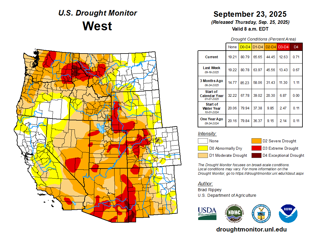
: It was a challenging period for drought monitoring, with a broad mix of improvement and deterioration. Additionally, a significant rainfall event was underway in parts of the central, eastern, and southern U.S. when the drought-monitoring period ended early Tuesday. Any precipitation that fell after the Tuesday cutoff will be considered for next week’s map. Broadly, precipitation fell across the Plains, Midwest, and mid-South, mostly from the central Rockies to the western slopes of the Appalachians. Locally significant showers also dotted the Southwest, providing limited drought relief but triggering flash flooding. In contrast, mostly dry weather prevailed in the Northwest, Intermountain West, Deep South, and along much of the Atlantic Coast…
Most of the region is free of drought or received drought-easing precipitation, including some high-elevation snow in the central Rockies. Although rain slowed fieldwork, including summer crop harvesting and winter wheat planting, moisture should benefit rangeland, pastures, and fall-sown crops…
Colorado Drought Monitor one week change map ending September 23, 2025.
Worsening drought in parts of the Northwest contrasted with locally heavy showers farther south. In the Southwest, those showers led to targeted drought improvement, but also resulted in spotty flash flooding in some of the nation’s driest locations, including Death Valley, California. Farther north, the U.S. Department of Agriculture reported that statewide topsoil moisture (on September 21) was rated 92% very short to short in Washington, along with 80% in Oregon. Winter wheat planting has been advancing quickly in Washington and was 58% complete by September 21. Any fall-sown Northwestern crops will soon need moisture for proper autumn establishment. Currently, at least 45% of the rangeland and pastures in all Northwestern States were rated very poor to poor, led by Montana (61%)…
Looking Ahead
Rainfall will continue to shift southward and eastward, resulting in a boost in soil moisture in many areas experiencing short-term drought. Five-day rainfall should reach 1 to 3 inches or more across much of the eastern U.S., as well as portions of the Gulf Coast States. Once rain ends across the Plains and Midwest, dry weather will prevail for the next several days. Dry weather should extend into the Northwest until late in the weekend, when showers will arrive along the northern Pacific Coast. Elsewhere, a late-season monsoon surge will result in unusually heavy showers for this time of year in parts of the Southwest, leading to another round of possible flash flooding.
The NWS 6- to 10-day outlook for September 30 – October 4 calls for near- or above-normal temperatures nationwide, with the north-central U.S. having the greatest likelihood of experiencing warmer-than-normal weather. Meanwhile, near- or above-normal precipitation across most of the country should contrast with drier-than-normal weather in a band stretching from the southern Plains into the Great Lakes region and the Northeast.
US Drought Monitor one week change map ending September 23, 2025.
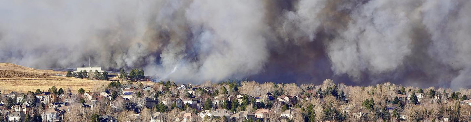
Marshall Fire December 30, 2021. Photo credit: Boulder County
Click the link to read the article on the Big Pivots website (Allen Best):
September 24, 2025
Xcel Energy, Qwest Corporation, and Teleport Communications America have reached agreements in principle to settle all claims asserted by subrogation insurers, the public entity plaintiffs, and individual plaintiffs.
Xcel Energy, through its subsidiary, Public Service Company of Colorado, expects to pay $640 million related to these settlements. Of that, $350 million is to come from insurance coverage and none from its customers.
The agreements in principle remain subject to final documentation and individual plaintiffs opting in to the agreement negotiated and recommended by their counsel.
Xcel Energy does not admit any fault, wrongdoing, or negligence in connection with this resolution.
“Despite our conviction that PSCo equipment did not cause the Marshall Fire or plaintiffs’ damages, we have always been open to a resolution that properly accounts for the strong defenses we have to these claims. In resolving all liability from the claims, this settlement reinforces our longstanding commitment to supporting the communities we serve,” said Bob Frenzel, chairman, president and CEO of Xcel Energy, in a statement released by Xcel.
“We recognize that the fire and its aftermath have been difficult and painful for many, and we hope that our and the telecom defendants’ contributions in today’s settlement can bring some closure for the community.”
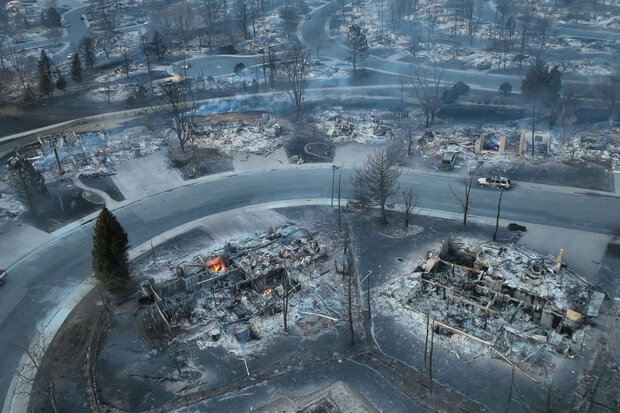
The Marshall Fire left smoldering ruins in a Louisville, Colorado, neighborhood, at the end of December 2021. Photo courtesy WXChasing. Used with permission.
Xcel has developed a comprehensive strategy to reduce wildfire risk and improve grid resilience. See more about that plan here. The 2025-27 Wildfire Mitigation Plan includes investments in system resilience, improved situational awareness of high-risk fire scenarios, enhanced operations and maintenance practices to mitigate fire risk and increased engagement with state and local agencies.
This plan, which is informed by inputs from local communities and governments, includes specific improvements for Boulder County, including undergrounding certain power lines and modernizing energy delivery infrastructure.
The Marshall Fire started December 30, 2021, from an ignition on the Twelve Tribes property in Boulder County, when embers from an earlier debris burn reignited. The fire, fueled by high winds, spread quickly to the towns of Louisville and Superior. A second ignition occurred nearby approximately 80 minutes later.
The plaintiffs filed lawsuits seeking billions of dollars in damages against Xcel Energy and the telecom defendants in connection with the second ignition. Xcel Energy disputes that its equipment was involved in the second ignition.
For the most part, President Donald Trump has done everything we feared the candidate would do and then some: following Project 2025 to a T, gutting environmental and public health protections, shredding the First Amendment (to the point of even losing Tucker Carlson), threatening political opponents, and generally embracing authoritarianism.
But when it comes to public lands, there is actually one act we expected the administration to do shortly after the inauguration, but that it hasn’t yet attempted: Shrinking or eliminating national monuments, especially those designated during the Clinton, Obama, and Biden administrations. Even after Trump’s Justice Department opined (wrongly, I’d say) that the Antiquities Act authorizes a president to shrink or revoke national monuments, the administration didn’t actually do it.
I suspect this is because they realize how deeply unpopular that would be. Sure, Trump’s first-term shrinkage of Grand Staircase-Escalante and Bears Ears national monuments may have garnered some support from a handful of Utah right-wingers, but they’d be behind him regardless. Meanwhile, it pissed off a lot of Americans who value public lands but might otherwise support Trump’s policies.
That’s not to say the national monuments are safe. It’s just that the administration seems to be intent, for now, to outsource their destruction to their friends in Congress. The House Republicans’ proposed budget, for example, would zero out funding for GSENM’s new management plan — a de facto shrinkage.
And now, Rep. Paul Gosar, a MAGA Republican from Arizona, has introduced bills that would nullify Baaj Nwaavjo I’tah Kukveni – Ancestral Footprints of the Grand Canyon National Monument and the Ironwood Forest National Monument northwest of Tucson. The former blocks new mining claims in an area that has been targeted for uranium extraction. And the latter, established by Bill Clinton in 2000, covers a 189,713-acre swath of ecologically rich Sonoran Desert near the gaping wound known as the Asarco Silver Bell copper mine. The national monument designation blocked new mining claims.
Interestingly enough, neither of the national monuments are in Gosar’s district, which covers the heavily Republican western edge of the state, so he won’t suffer from voter blowback if the legislation succeeds.
⛏️ Mining Monitor ⛏️
Congressional Republicans, with some Democratic support, are again trying to pass legislation that would allow mining companies to dump their waste on public lands.
The Mining Regulatory Clarity Act of 2025, introduced by Rep. Mark Amodei, R-Nevada, made it through the House Natural Resources Committee this week on a 25-17 vote. It would tweak the 1872 Mining Law to ensure that mining companies can store tailings and other mining-related waste on public land mining claims that aren’t valid, meaning the claimant has not proven that the parcels contain valuable minerals. This was actually the norm for decades until 2022, when a federal judge ruled that the proposed Rosemont copper mine in Arizona could not store its tailings and waste rock on public land. That ruling was followed by a similar one in 2023, leading mining state politicians from both parties to try to restore the pre-Rosemont Decision rules.
The bill would supplement Trump’s executive order from March invoking the Defense Production Act to expedite mining on public lands, and his “emergency” order that fast-tracks mining and energy permitting on public lands.
***
Photo credit: Jonathan P. Thompson/The Land Desk
IsoEnergy, the company that owns the controversial Daneros Mine just outside Bears Ears National Monument and the Tony M Mine,plans to begin exploratory drilling at its Flatiron claims in Utah’s Henry Mountain uranium district. Last year, the Canada-based company staked a whopping 370 lode claims on federal land. Along with two Utah state leases, this adds up to about 8,800 acres south-southwest of Mt. Hillers.
🛢️ Hydrocarbon Hoedown
A peer-reviewed study out of UCLA recently found that pregnant women living near the Aliso Canyon natural gas storage facility in Los Angeles during the sustained blowout of 2015 experienced more adverse birth outcomes than expected. Specifically, the prevalence of low birthweight was 45% to 100% higher than those living outside the affected area. This should concern not only folks living near Aliso Canyon (which is still operational), but also anyone who lives near an oil and gas well or other facility.
Aliso Canyon is a depleted oil field in the hills of the Santa Susana Mountains in northern LA. Southern California Gas pipes in natural gas, pumps it into the oil field, and stores up to 84 billion cubic feet of the fuel there. In October 2015, one of the wells blew out and for the next 112 days spewed a total of about 109,000 metric tons of methane, a potent greenhouse gas and the main ingredient of natural gas.
That’s bad. But also mixed into the toxic soup that erupted from the field were other compounds such as mercaptans including tetrahydrothiophene and t-butyl mercaptan, sulfides, n-hexane, styrene, toluene, and benzene. All really nasty stuff that you don’t want in your air, and that is often emitted by oil and gas wells. The authors write:
“The emissions of BTEX and other HAP compounds are of particular concern as even at levels below health benchmarks they have been linked to health effects, including neurological, respiratory, and developmental effects.”
That appears to have been the case with the Aliso Canyon blowout, where “low birth weight and term low birth weight was higher than expected among women living in the affected area whose late pregnancy overlapped with the disaster.”
It’s simply more confirmation that fossil fuel development and consumption can take a big toll on the environment, the climate, and the people who live in or near the oil and gas patch or associated infrastructure. And that limits on methane emissions are important, even if you don’t care about climate change.
***
Long-time Land Desk readers might remember my story about the Horseshoe Gallup oil and gas field and sacrifice zone in northwestern New Mexico. I wrote about how the area had been ravaged by years of drilling and largely unfettered development, how the wells had been sold or handed off to increasingly irresponsible and slipshod companies as they were depleted, and how that had left dozens of abandoned facilities, oozing and seeping nasty stuff, but were not cleaned up because state and federal regulators still considered them to be “active.”
The field is still there, along with most of the abandoned wells. But Capital & Main’s Jerry Redfern reports that some of the worst sites, including the NE Hogback 53, are being cleaned up. Well, sort of. The extensive reclamation of the well and the tank battery was started, only to be halted in May at the end of the state’s fiscal year. It resumed in July, and is expected to cost about $650,000.
This highlights the need for stronger enforcement and, most importantly, adequate reclamation bond requirements. At prices like that, cleaning up just the Horseshoe Gallup could cost tens of millions of dollars, and the taxpayer will be left to shoulder most of the bill.
🥵 Aridification Watch 🐫
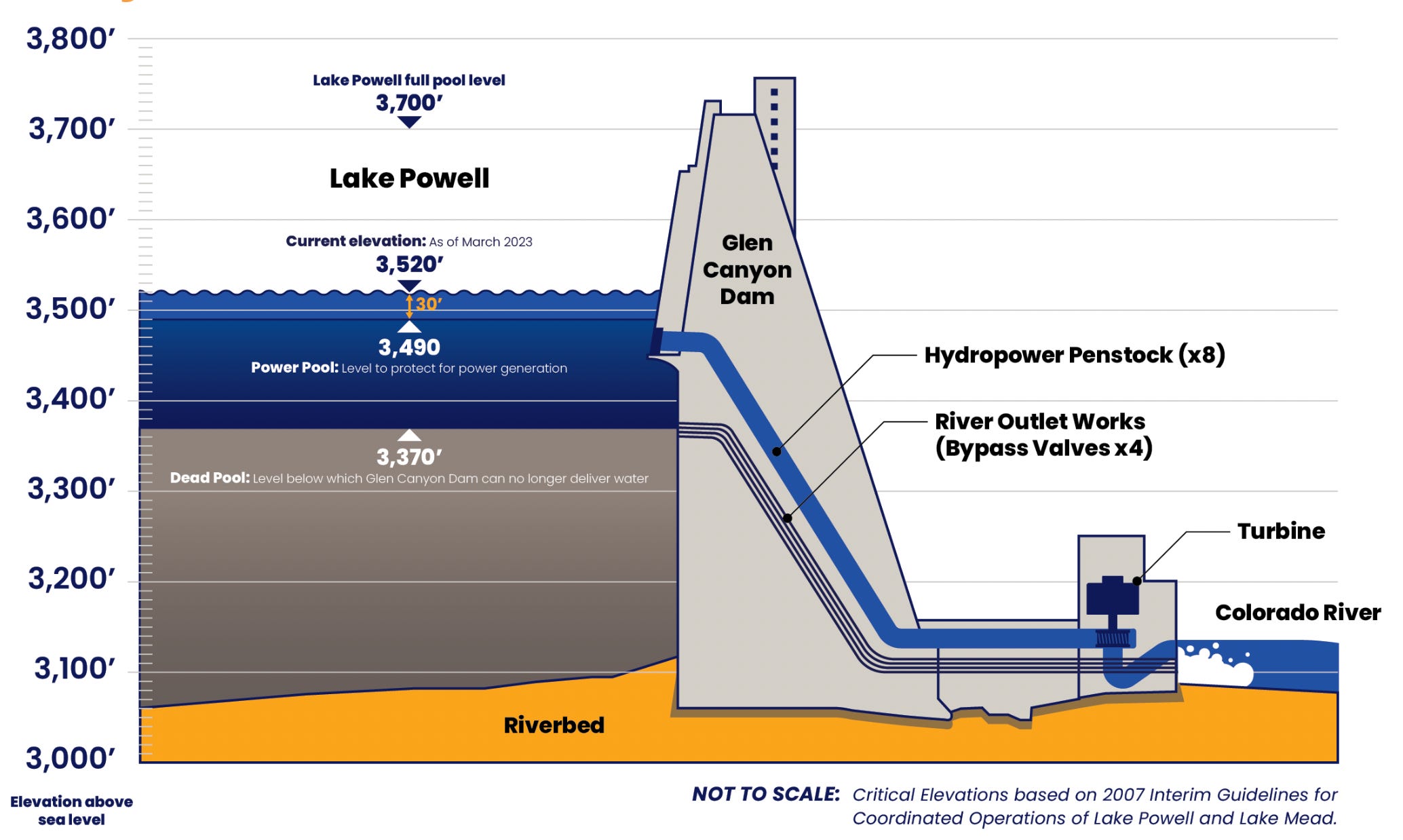
Clarification: In Tuesday’s dispatch on the Colorado River and Lake Powell, I wrote that another dry winter would put “… the elevation of Lake Powell at 3,500 feet by this time next year. And, due to the infrastructure’s limitations, Glen Canyon Dam would have to be operated as a ‘run of the river’ facility.” That probably needs a bit more explanation.
One smart reader pointed out that even after the surface level of Lake Powell drops below minimum power pool, or 3,490 feet in elevation, the dam can still release up to 15,000 cfs from its river outlets. Technically, managers would not be forced to go to run of the river until the surface level dropped below 3,370 feet, which is known as “dead pool.”
However, the Bureau of Reclamation is very wary of relying on the river outlets, because they weren’t designed for long-term use and could fail under those circumstances. So, BoR is intent on keeping the water levels above minimum power pool so that all releases can go through the penstocks and the hydroelectric turbines. “In effect,” the authors of the paper wrote, “at least for the short term, the engineering and safety issues associated with the ability to release water through Glen Canyon Dam mean that the amount of water actually available for release from Lake Powell is only that which exists above elevation 3500 feet.”
So, as long as this is the case, the BoR will need to go to run of the river as soon as the elevation drops to 3,500 feet. I hope that helps clear things up!
🗺️ Messing with Maps 🧭
Today’s map is less about the map than it is about the publication it comes from, the USGS’s Guidebook of the Western United States Part E. the Denver & Rio Grande Western Route, published in 1922. This thing is super cool, and super detailed (it’s 384 pages long). It’s got some great photos and maps, like this one (click on the image to see it in larger size on the website).
Besides having a cool, hand drawn style, this map struck me because it was made prior to the reservoirs on the Gunnison River. And it shows how the railroad tracks used to go into the Black Canyon at Cimarron and continue along the river all the way to Gunnison (most of that section is now under water). I suppose I should have known that was where the tracks went, but it never really occurred to me before. Credit: USGS
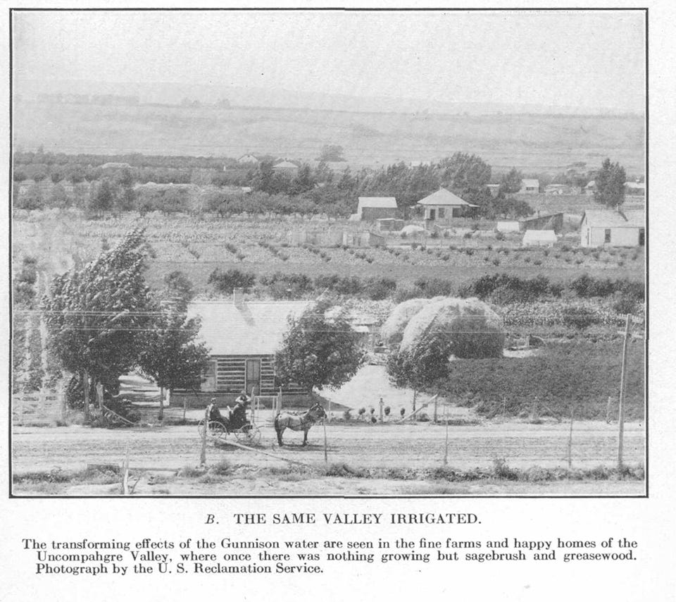
Related to that map were these two photos illustrating the miracle of irrigation.