Click the link to read the article on the Colorado Climate Center website (Russ Schumacher):
February 9, 2026
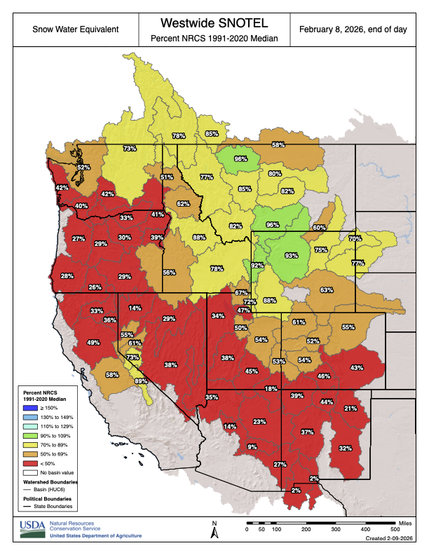
Colorado’s mountain snowpack is in bad shape this year. It’s been extremely warm, and snowstorms have been few and far between. Based on data from the SNOTEL network, the amount of water stored in the snow is the lowest at this point in the winter since at least 1987. Sometimes when one part of the state is lacking for snow, another region is doing ok, but not this year. Essentially all of Colorado is in a snow drought.
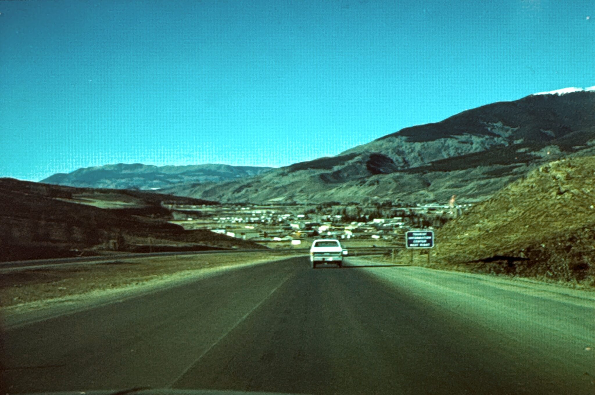
Snow droughts have been getting more common in Colorado in the 21st century. But those who have been around Colorado longer than I have may also remember two other terrible winters for snow: 1976-77 and 1980-81. In fact, some photos sit on my desk from former state climatologist Nolan Doesken from tours through the mountains in those years. At that time, snowmaking was uncommon at the ski resorts, and there were serious concerns about whether the ski industry would survive through those two historic snow droughts. (This story from 2012 by Jason Blevins, then at the Denver Post, now at the Colorado Sun, has some relevant background.) We’ve been fielding quite a few questions about how the snowpack this winter compares to those brutal years, so let’s take a closer look.

First, a bit about snow measurements
Because of the importance of mountain snow to water supplies, the federal government (specifically, the Department of Agriculture) has for decades collected snowpack data across the western US. The USDA snow survey was established in the 1930s, with routine “snow course” measurements in the winter and spring. These are manual measurements of the snow depth, snow water equivalent, and so on. (Here’s some archival footage of snow surveying. I believe that smoking a pipe while taking the measurements is discouraged these days.)

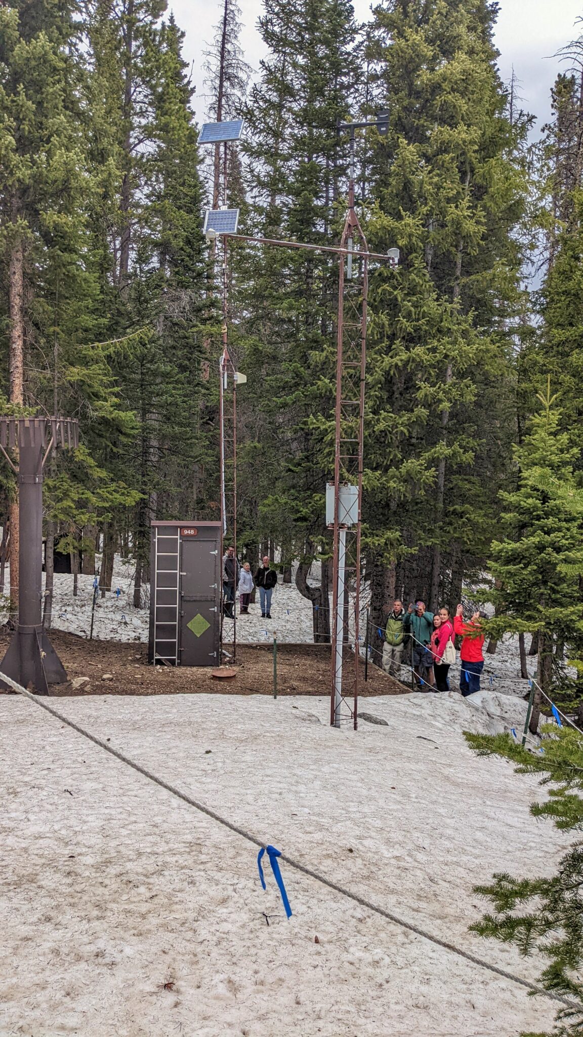
Measuring snow this way takes a lot of time and effort, however. So the 2nd pillar of the USDA’s snow survey program, the “Snow Telemetry” or SNOTEL network, was established starting in the 1960s. These are automated stations that use a “snow pillow” to measure the weight of the snow, and convert that into an amount of liquid water, among other measurements. SNOTEL data allow agricultural producers, water managers, climatologists, and the public to keep tabs on the snowpack in near-real-time. The snow course measurements have the advantage of a longer period of record to compare to, but are only collected once a month from February through May; the SNOTEL data are available daily from over 100 stations but with a shorter period of record.
What do the data show for this winter?
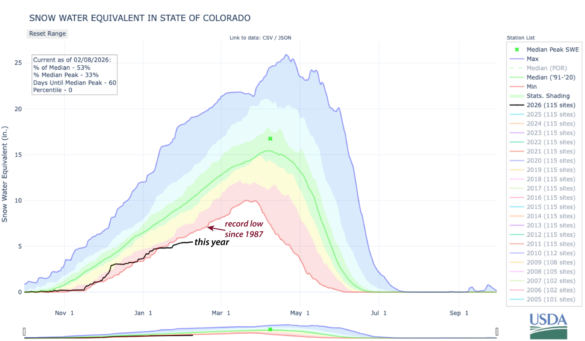
The graph up at the top shows that in the SNOTEL era, Colorado’s snowpack is the worst on record as of early February. However, there weren’t yet any SNOTEL stations in Colorado for the 1976-77 winter, and the network was still being built out as of 1980-81. So, if we want to compare the current snowpack to those two years, we’ll have to take a look at the tried-and-true snow course measurements, which the USDA has been collecting for the first time this season over the last week or so.
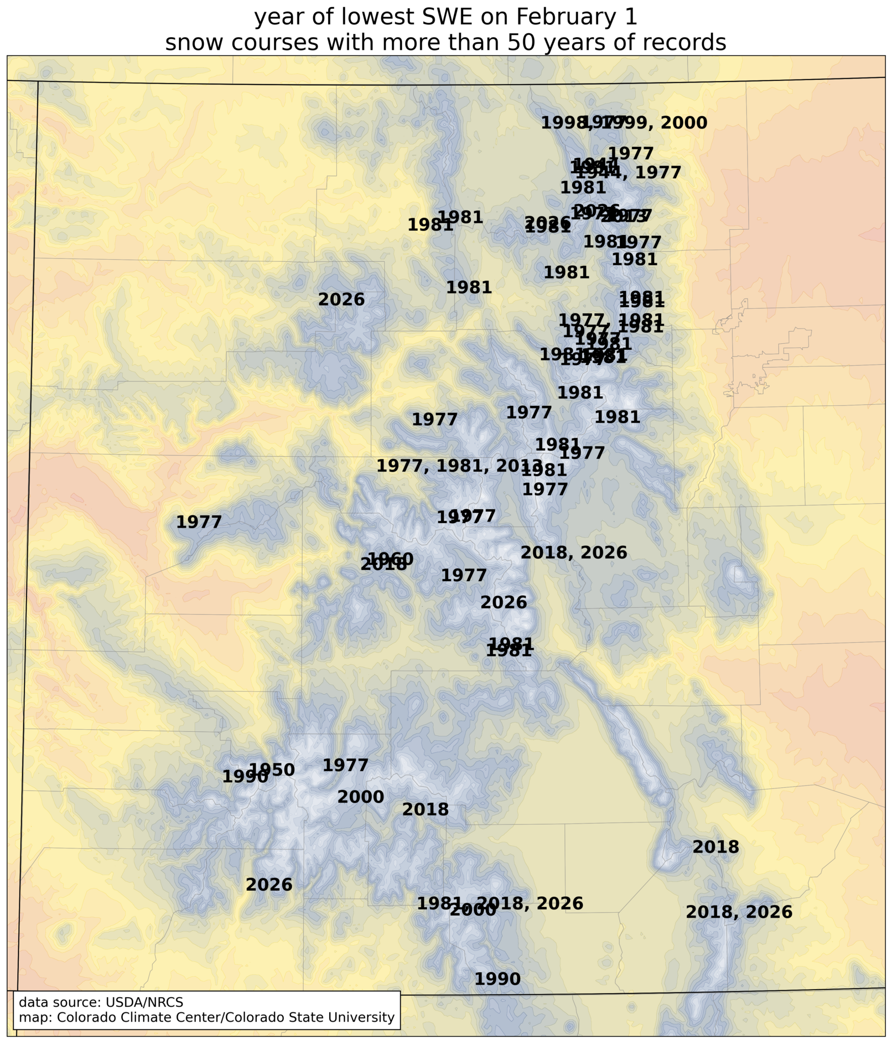
When comparing the snow water equivalent on February 1st at 62 snow courses with more than 50 years of data, there are eight sites where this year (2026) is the lowest on record. They are shown with the dark brown circles on the map below. Another fourteen sites have either the 2nd or 3rd lowest snowpack on record, and many more are in the bottom 10 years historically.
We can also look at which years had the lowest SWE as of February 1. At the locations where this year isn’t the worst snowpack, the worst February conditions were generally either in 1977 or 1981 (with some dishonorable mention to 2018 in the southern mountains.)
Using data from 20 snow course sites in Colorado with consistent data back to at least 1940, we can see that this year has the lowest snow water equivalent since the two terrible years of 1977 and 1981, and lower than any of the other years in the record.
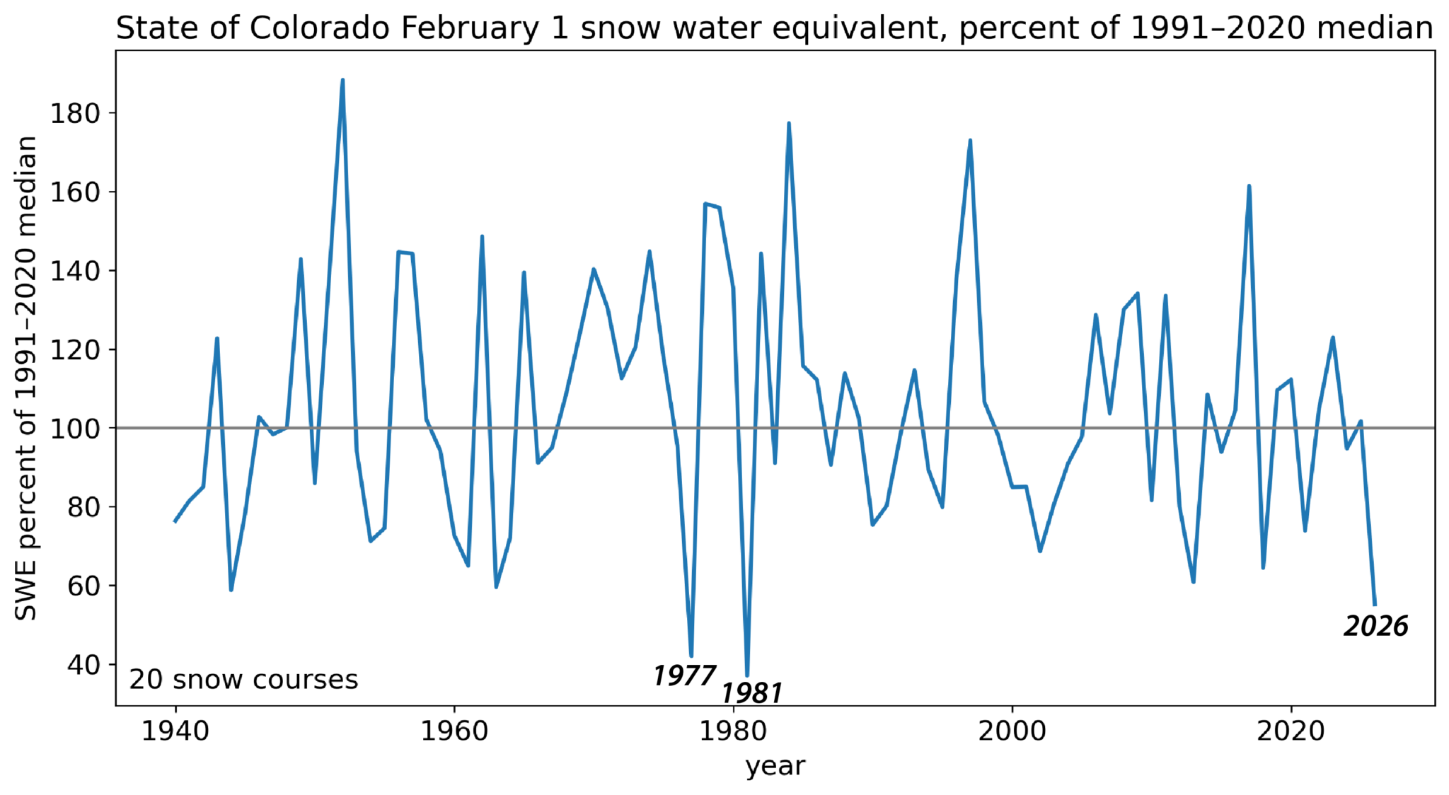
So, it’s fair to say that this year so far has the worst snowpack in Colorado in over 40 years. But in most locations it’s not quite as bad as the conditions were in 1976-77 and 1980-81.
However, obviously a lot of things have changed since the late 1970s! Nearly all ski areas now have robust snowmaking operations, which allow them to keep terrain open even when there’s not much snow falling from the sky. On the flip side, the population of Colorado has grown immensely—approximately twice as many people live in the state now as did in 1980. Which means that the demand for water (and for winter recreation) is much greater, and thus the potential impacts of a snow drought are much greater as well.
What has really set this water year apart thus far is how warm it’s been. For Colorado statewide, we just had the 3rd warmest November and the warmest December in over 130 years of records. January was very warm as well. Official numbers for January will be released this week (make sure you’re signed up to get our monthly summaries), but it clearly ranked among the top 20 warmest Januarys, and early February has continued the streak of warmth. The warmest start to a water year we’ve ever seen, combined with a lack of the snowstorms we typically see in winter, has brought us to the worst mid-winter mountain snowpack in decades.
We do still have about 2 months to go before the mountain snowpack typically hits its peak, which means there is still time to chip away at the deficit. Looking back at the major mid-winter snow droughts discussed above, in 1977 it remained dry in late winter and spring, and that season still holds the record for worst April 1 snowpack at many locations in Colorado. In contrast, the spring of 1981 was fairly active; at least enough to emerge above record-low territory for much of the state.
This week, the pattern will finally shift away from warm and sunny conditions to more consistent chances for snowfall. However, it’s too early to say how long the incoming pattern will stick around, and unfortunately there aren’t any blockbuster storm cycles on the horizon in the near term. An active spring would certainly be very welcome, but the odds of rebounding to near normal peak snowpack conditions are dwindling. More realistically, we are just hoping to get enough snow to avoid a historically bad year.
*special thanks to Brian Domonkos of the USDA/NRCS Colorado Snow Survey for providing useful details about this year’s snow course measurements