
Click the link to read the article on the Big Pivots website (Allen Best):
February 17, 2026
Sitting in the audience at the Colorado Water Congress in January, I was reminded of the days, weeks and months after 9/11. The impulse –– fueled by rage, was to punch back — at somebody, somewhere. The result, as we saw in Afghanistan after 20 years and three presidents, was far from satisfying. Osama bin Laden died, but the Taliban prevailed.
At the conference, a new state legislator from the Western Slope was full of righteous indignation about the Colorado River dispute. Colorado and other upper basin states were right, and those in the lower basin were wrong. We will prevail in court, he insisted. That would be the Supreme Court, where all disputes among states must go. And Colorado, legislators had been told, is preparing for just that possibility.
Much is at stake here. It’s not just ranches on the Western Slope but nearly all the water rights allocated since 1922. Roughly half of water for Front Range cities comes from the Colorado River headwaters and for towns on the eastern plains as far east as Fort Morgan. The mountains towns at the Colorado River headwaters, most of their water rights are post-1922. The list goes on and one.
No wonder Colorado has its fur up.
Speaking later in the morning, Jim Lochhead, a figure prominent in Colorado water affairs since the 1970s, did not disagree with Colorado’s fundamental position.
Colorado insists that Arizona and California, especially, have caused the big reservoirs, Powell and Mead, to decline. The states — together, with Nevada, they constitute the lower basin — have reduced their water use substantially since 2002 — but not in proportion to the declines caused by warming temperatures and declining snowfall. The lower-basin states created the problem of the reservoirs now at perilously low levels. They bear the heaviest burden of refilling reservoirs by simply agreeing to take less water.
Lochhead also warned of inflexibility. “The upper basin cannot bail out the lower basin,” he said. “But (negotiators) have to be given room to compromise.”
“If the negotiators are forced to focus only on protecting what each of them thinks is legally theirs on paper, they can’t work on identifying and building the tools and strategies needed to make sure we can get away from crisis management and secure our future,” he said that January morning in Aurora.
Upper-basin states say that because they are at the headwaters, they have nothing equivalent to Powell and Mead upstream to provide certainty. If it rains and snows, there is water. If not, then water users have less or none. Colorado water officials say some with water rights dating to the 1880s have already had to go without.
The year 2002 was seminal. Modest snowfall was followed by an early and unusually warm spring. Peak runoff was barely noticeable. In Denver, a city that gets half its water from the Colorado River headwaters, sprinklers were turned off, green grass turned brown. Aurora, also heavily dependent upon Colorado River water, was within a few months of crisis in 2003 when a miracle occurred –– three feet of snow on St. Patrick’s Day.
Downstream in Arizona and California, far from this drama in the headwaters, life continued with no fear and little change. The upstream reservoirs, Powell and Mead, had water.
We have another dry year, and the Colorado River right now is expected to deliver less than the 3.8 million acre-feet at Lee Ferry, just below Glen Canyon Dam, than it did in 2002. Flows were 17 to 18 million acre-feet in the 1920s, when the Colorado River Compact was created and adopted. The long-term average was less, 14.6 to 15.1 million acre-feet. In this century, it has dipped to 12.1 to 12.5 million acre-feet. Some expect this trend to continue amid the warming and drying now underway in the basin. Might it go below 10 in a few more decades?
The lower basin until relatively recently used 10 to 11 million acre-feet. As for the upper basin, states — Wyoming, Utah and New Mexico, in addition to Colorado —they have used 3.5 to 4.5 million acre-feet. It depends upon whether it snows.

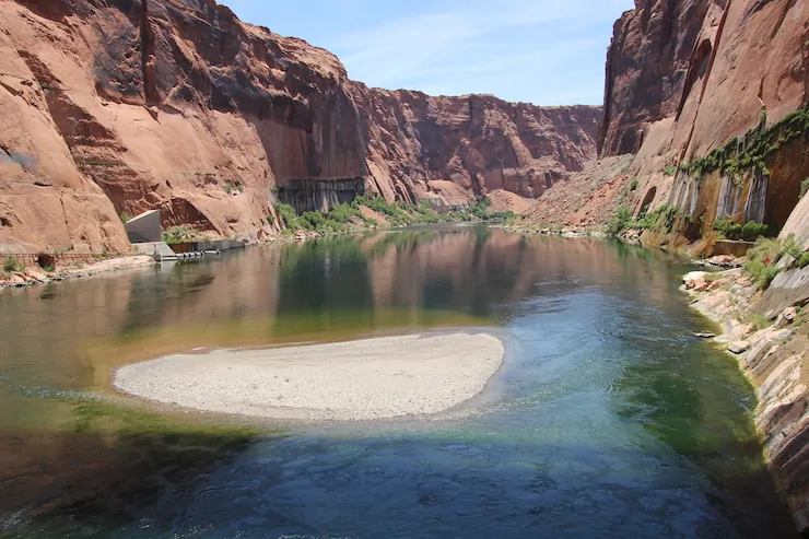
“Everyone knows Lake Powell is now in a dire situation,” said Lochhead in a panel after the state legislators had left. “We have gone from 86% full to I think around 25% full today. Powell is in danger of being over a million acre-feet below deadpool next year. That should scare all of us.”
Deadpool is when the water level in a dam-created reservoir drops so low that water cannot be released and used for drinking, irrigation and power. In the last several years, at least one book, Zak Podmore’s Life After Dead Pool, has been written about the Colorado River with that threshold in mind. Other books and thousands and thousands of newspaper, magazine and website postings have mentioned it.

Lochhead warned against hardened positions that put the Colorado River problems in front of the Supreme Court. Colorado has not fared well in water cases there the last 100-plus years.
For several decades, Lochhead was a water attorney for Holland and Hart, working from an office across from the post office in Glenwood Springs. It was a good place to raise a family of skiers, he once told this writer.
During that time on the Western Slope, Lochhead represented Colorado on Colorado River affairs in several capacities. Then, from 2010 until 2023, he was CEO of Denver Water, the state’s largest water utility. In the last few years, his life has been lower profile. But, as his remarks at the Water Congress demonstrated, he is still paying close attention.
Litigation in the Colorado River Basin, said Lochhead, is a “worst-case scenario, resulting in economic and political disruption and uncertainty no matter the outcome.” This message, he said, would be the same whether given to audiences in Arizona or Colorado.
“There are tens of millions of dollars of taxpayer dollars that will be spent on litigation over a 10- or 20-year period, and the outcomes will be uncertain. The upper basin has a lot of good arguments, and so does the lower basin.”
Colorado appeared before the Supreme Court in 1907. It claimed full use of the Arkansas River. The Supreme Court disagreed.

In 1922, Colorado lost to Wyoming in a case involving the North Platte River. Colorado has insisted upon prerogatives because it was the source of the water. That defeat caused Colorado’s lead negotiator, Delph Carpenter, to conclude it must shelve the idea that being at the headwaters would trump the claims of downstream states on the Colorado River. Carpenter became the most important figure in crafting the Colorado River Compact of 1922.
“But of course, litigation under the compacts continued, and Colorado was ordered to pay some $34 million to Kansas in 2001 and to dry up Bonnie Reservoir and undertake the process of drying up 25,000 acres of farmland in the Republican River Basin,” Lochhead continued.

Lochhead described several layers of complexities.
“This isn’t litigation just between two or three states. This is litigation between four states that have a common obligation under the compact (the Upper Basin) versus three other states requiring coordination on strategy, negotiating remedies and settlement between the states,” he said.
Nor is it simple a matter of the two basins, upper and lower, in conflict. The 30 federally recognized tribes in the Colorado River Basin have their interests, and they are not all the same. They also have rights that in most cases supersede those of the states. Public interest groups can have different interests. And, if the federal government makes the decisions about future uses of the Colorado, each and all may “sue the federal government over any unilateral federal action or decision, and that litigation can take all kinds of different forms.”
“Other entities may seek to intervene in the litigation. The United States certainly would, as we have seen in Texas versus New Mexico. But when tribes seek to intervene, if the country of Mexico seeks to intervene — what happens during litigation?”
Mexico, under a 1944 compact, is to get 1.5 million acre-feet annually.
Plus, the three other upper-basin states may disagree with Colorado. Colorado uses by far the most water of the four, as a compact among them reached in 1948 specified. Alone, though, it has pushed that limit.
In other words, going to water war sounds vaguely patriotic. The reality of the courtroom may be less heart-thumping.

Consider what if Colorado did lose? Here’s where the story gets grim. The Front Range cities, the ski towns, even farmers in the South Platte and Arkansas valleys to the Nebraska and Kansas borders.
Lochhead described the stakes involved, the gamble of letting the black-robed justices in D.C. decide the fates of the seven base states. “Do we find ways to work together across the basin to address the crisis together?”
He asked that question more than two weeks before Valentine’s Day, the deadline set by the Bureau of Reclamation without obvious irony. Without agreement by the seven states about how to share the diminished river, it is now up to the federal government to step in. On Friday, after the states had reported still no break-through, I asked Lochhead by e-mail if his remarks from January were still appropriate. They were, he said.
“It seems as I write this, that — as for the last two years — the states remain stuck in political talking points and the federal government is not applying necessary pressure. And, in the meantime, Lake Powell is headed toward run-of-the-river operations, which precipitates crises on all kinds of different levels,” he replied. “This will lead to the federal government having to make decisions that will severely impact both upper and lower basin economies and the environment, not to mention endless, expensive and risky litigation. This all could have been avoided but here we are.”
“Wow!” said Eric Kuhn, a former general manager of the Colorado River District in Glenwood Springs, in a LinkedIn post over the weekend. “The secretary (of Interior) needs to step up and make some hard decisions!”
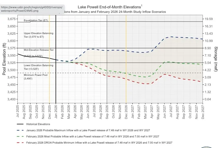
Sparking Kuhn’s remarks was a new Bureau of Reclamation report on Friday of probable flows in the next two years. The best of them leaves Powell in bad shape. In fact, the bureau’s “probable” flows have frequently been too optimistic. The dimmer view, called “probable minimum,” sees Powell levels dropping below the elevation needed to produce hydropower as early as August. Minimum power pool is above deadpool.
From a Colorado perspective, lower-basin states have a sense of entitlement that defies common sense. Whether it defies the law is another matter. Kuhn told me years ago that the key provision in the 1922 compact that can be interpreted in two very different ways.
It says: “The States of the Upper Division will note cause the flow of the river at Lee Ferry to be depleted below an aggregate of 75,000,000 acre feet for any period of ten consecutive years…”
Yes, there was a typo in the original compact: “note,” instead of “not.”
But as to that disagreement: Upper-basin states see this meaning that they have no control over the weather. They did not cause the reduced flows. Hang the weather, says the lower-basin state. The “do not cause” clause means that if only 7.5 million acre-feet is all that is in the river, it all has to flow downstream.
Typo or not, the lower-basin perspective sees this as a cut-and-dried issue. If Denver must go without transmountain diversions or taps in Winter Park or Vail must go dry, so be it. Not their problem.
JB Hamby, California’s representative on Colorado River affairs, articulated exactly that sentiment on Friday. “The 1922 Colorado River Compact requires the Upper Basin to deliver an average of 8.25 million acre-feet annually to the Lower Basin and Mexico,” he said in a statement. “That delivery obligation is fixed in law, even when the river produces less water.”
At the January forum, Amy Ostdiek, who heads the legal team for the Colorado Water Conservation Board in interstate and federal matters, laid out the basic numbers Colorado puts front and center: The 1922 compact laid out a split of roughly 7.5 million acre-feet for each, the lower and upper basins, with the upper basin required to allow another one million acre-feet to flow down river to account for evaporation and losses.
“We have to be honest about what has caused the threat that Lake Powell might not be able to make the releases that the lower-basin states believe they are entitled to. It was directly caused by their overuse of Lake Mead, which drew down Lake Powell to the point it is today,” said Ostdiek.
Again, the upper-basin states insist upon lower-basin states sharing the uncertainty of snow and rain. To rebuild the storages will mean they take less water.
“This is going to be hard for those who are not accustomed to taking less in dry years, but the benefit of reaching a state-state deal is that if we’re able to do that, it provides an opportunity or a gradual and softer landing — and more likely federal dollars for those who need that support as they adapt to this reality.”
The upper basin, though, refuses to budge on the idea that it can develop all 7.5 million acre-feet of water apportioned it by the compact — if the water is there, of course.
In their January remarks, neither Lochhead nor Ostdiek offered thoughts about on-the-ground solutions. Ostdiek pointed to programs in both the upper and lower basin with varying success. In their defense, they only had an hour.
Can the lower-basin negotiators truly misunderstand Colorado’s position? Ken Neubecker, of Glenwood Springs, formerly of environmental groups, thinks so.
“They have been accustomed, some would say addicted, to the reliable delivery of stored water for all their needs since Hoover Dam was built and began releasing stored water some 90 years ago,” he wrote in a post on Substack. “Only until very recently, even in the face of an unrelenting drought, have they had to deal with shortages. For the Upper Basin, shortage is an annual reality.”
Rod Proffitt, from Pagosa Springs, (and a board member for Big Pivots) points to Arizona’s history of going to courts to resolve river issues. “They even sent out the National Guard one time” (in a dispute with California),” he observed. And now Arizona, more than any other state, has its back to the wall.

Most instructive, at least as understanding Arizona, may be George Packer’s 25,000-word piece, “What Will Become of American Civilization,” in the July/August 2024 issue of The Atlantic. During the prior year, Packer had spent several weeks or more, winter and summer, primarily in the Phoenix metropolitan region, to analyze its politics and people.
Most perplexing, he found, was the perfervid belief in population and commercial expansion that defies limitations of a climate where a simple fall onto concrete during summer can produce second-degree burns.
Colorado, of course, has its own love of economic expansion. It is dwarfed by Arizona. The latter grew 824% in population from 1950 to 2016 while Colorado grew 318%.
Water is crucial to these expansions, and Arizona has tried to disregard limits. Packer explicitly uses “water” 158 times in his report and implicitly so elsewhere. He started out with a description of the Hohokam Indians and their water infrastructure that can still be seen in Phoenix. He barely mentioned climate change but did use “heat” 32 times. He talks about water for data centers and the suburban sprawl.
“Phoenix makes you keenly aware of human artifice—its ingenuity and its fragility,” he says.
We’ve seen the ingenuity of water delivery systems in the broader Colorado River Basin, a region that extends from Colorado’s borders with Nebraska and Kansas to the Pacific Ocean. We now understand the fragility, and it makes us very, very uncomfortable.
Anything that forces change can bring out our worst, but then sometimes it can bring out our best. Can it get any worse on the Colorado River?
And also:
The five alternatives
The Bureau of Reclamation issued five alternatives in its draft environmental impact statement for how it will operate Glen Canyon Dam. The federal government, said Lochhead, can only implement two of them.
The first two, said Lochhead, are deeply flawed: No action and the second would impose shortages on Arizona and Nevada approaching 7 million acre-feet. Both alternatives would almost certainly be challenged in court. Both would quickly result in Powell reaching deadpool with compact litigation and unspecified federal actions in the upper basin to protect Powell.
The three other alternatives contain the essential elements of an agreement among the states, he said, including up to four million acre-feet of shortages in the lower base, but not by priority, and leaving pools in the two big reservoirs for conserved water by both upper and lower basins.
“Not surprising, the alternatives with the highest shortages in the two basins and the greatest flexibility perform the best again potential hydrology that illustrates the magnitude of the problem we’re in, and the actions required by both upper and lower basins to address it,” he said. For any of this to work, he added, “we need long-term funding to mitigate the impacts and build resilience in both basins.
A brief recent history:
Lochhead also sketched a brief history of agreements during recent decades on the Colorado River. His excerpted comments follow:
This slide shows the combined contents of lakes Powell and Mead for the last 25 years juxtaposed against some of the key events and agreements that have occurred during that 25-year period.
Despite the best efforts of the states, reservoir levels have continued to decline over time. The states, though, have made important agreements and have significantly reduced uses in response to changing conditions on the river. But clearly, much more needs to be done.

Starting in the early 1990s we had 10 years of negotiations that led to Federal Surplus Guidelines in 2001. You can see, at the beginning of this century, the reservoirs were virtually full, and we were arguing about surpluses.
Those guidelines also contained a deadline for California to finalize and implement the Quantification Settlement Agreement among California agencies to define priorities and implement ag-urban transfers necessary to get California’s water use from 5.3 million acre-feet a year down to 4.4 million acre-feet a year. The negotiations were driven by the direct involvement and pressure from Secretary (Bruce) Babbitt and his team at the Department Interior. That’s a theme — federal pressure being necessary to agreements of the Basin States over the last 25 years.
The California agencies had to come together and agree on how they were going to reduce their use by 800,000 acre-feet. They couldn’t reach agreement, and so Interior imposed limitations on water use in the Imperial Valley, prompting litigation that was eventually settled in 2003.
Lochhead credited Interior Secretary Gayle Norton and Bennet Raley, the assistant secretary for water, for pushing California to this agreement. Both, incidentally, were Colorado natives, Norton from Denver’s northern suburbs and Raley from southwest Colorado. Upon Raleys’ departure from the Interior in 2004, the Los Angeles Times had this to say:
“Raley may be remembered best as the folksy but firm bureaucrat who finally made good on the federal government’s long-standing threat to put California on a water diet. He did it by forcing the state to agree to stop using more than its share of the Colorado River, freeing up water for other Western states.”
Despite the arguments about surplus waters in the 1990s, some observers could see troubles ahead of a river overcommitted. Troubles arrived in a big way with the water-poor year of 2002 — a runoff that may turn out better than this year’s.
Lochhead recalled that the upper-basin states, wanting to maintain storage in Lake Powell, asked the Interior Department — the operator of the dam — to release less than 8.23 million acre-feet from the reservoir. Lower-basin states, primarily Arizona, resisted. Difficult meetings ensued, litigation was threatened, legal war chests were readied — then Norton interceded, issuing a deadline by the end of 2007 for an agreement about lower basin shortage guidelines and operational guidelines for releases of water from Powell and Mead.
The states met that deadline — unlike those of the last year — and the guidelines helped. But, said Lochhead, they have proven, over time, to be inadequate. It seemed like every year we were one foot over or under, those triggers that caused distrust and accusations between the upper and lower basins of gaming the system.
Meanwhile, the river produced less than anybody had expected. The states agreed to additional interim measures, and they, too, proved inadequate.
In 2019, the states agreed to a drought contingency plan and drought response agreement, more interim measures designed to protect the system’s major reservoirs from falling to critically low levels. The lower-basin states agreed to plan that added an extra layer of protection. The goal was to maintain a half million acre-feet of water in Lake Mead.
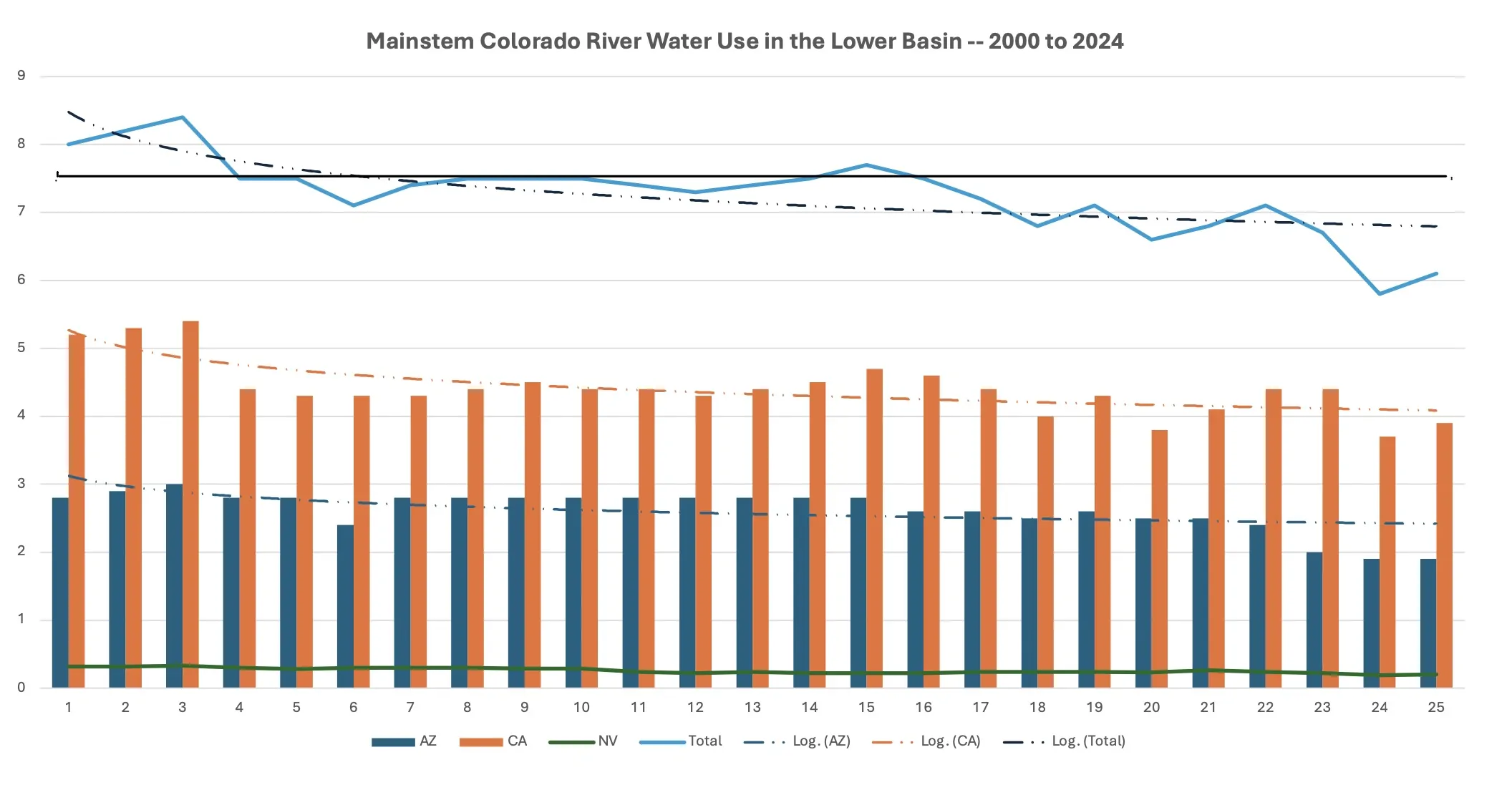
Declines in lower basin
Lochhead showed a chart of water use in the lower basin but with caveats. It did not include the tributaries, including the Gila River —- a conversation unto itself. Nor does it show reservoir evaporations and losses, which add up to about 1.5 million acre-feet annually, what is often called the structural deficit.
The blue line at the top showed a significant reduction in use starting in 2001, then a fairly steady use of about 7.5 million acre-feet until about 2017, when withdrawals begin to drop due to shortages.
Uneven use in upper basin
The next slide showed the variations of use by the upper-basin states. The chart shows ups and downs, which can be attributed to wetter and dryer cycles. Overall, though, water use in the upper-basin states has remained fairly constant. Those uses, he added, do not include reservoir evaporation — because those losses are explicitly included in upper-basin consumptive use.
“Part of the argument, part of the confusion, comes from these different accounting methodologies in the upper and lower basins,” he said.
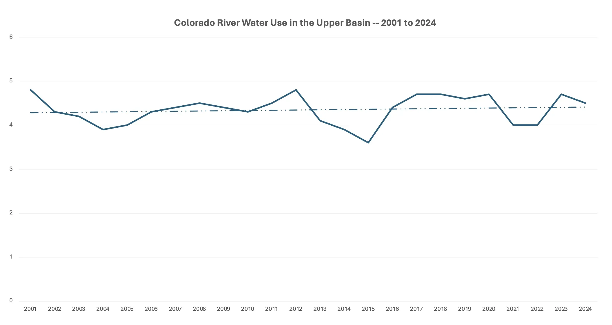
The upper basin has made a couple of arguments. One is that the upper basin has the right to develop more water, up to 7.5 million acre-feet, but also that hydrology is the limiting factor. Users suffer shortages every year. I’m not sure you can have both.”
Again, hydrology is the limiting factor.
