
Click the link to read the briefing on the Western Water Assessment website:
March 12, 2025 – CO, UT, WY
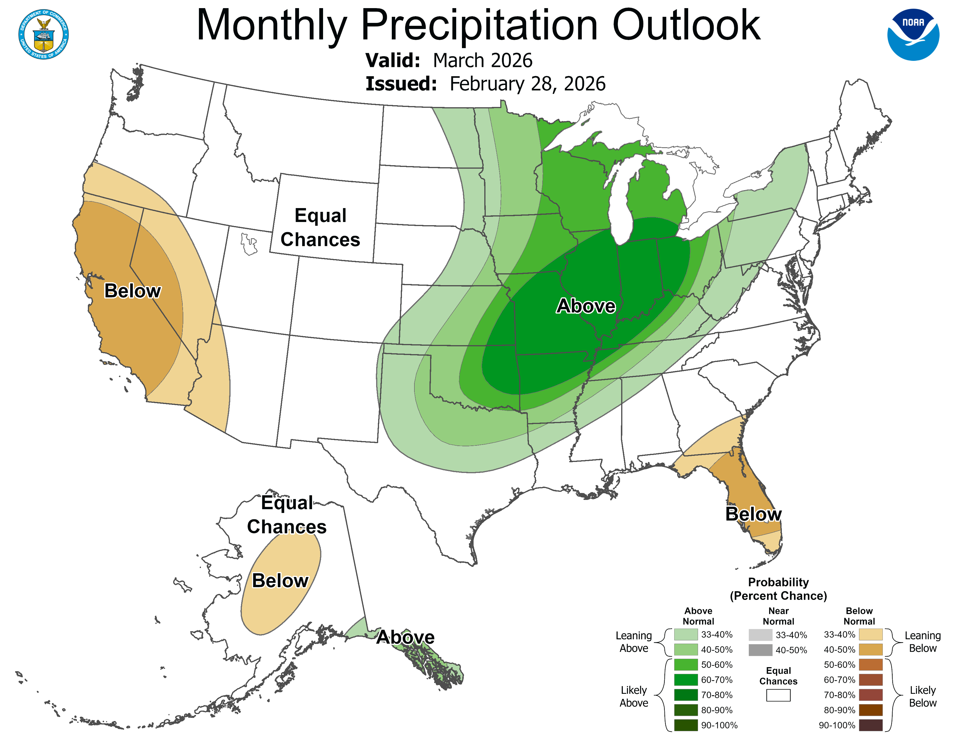
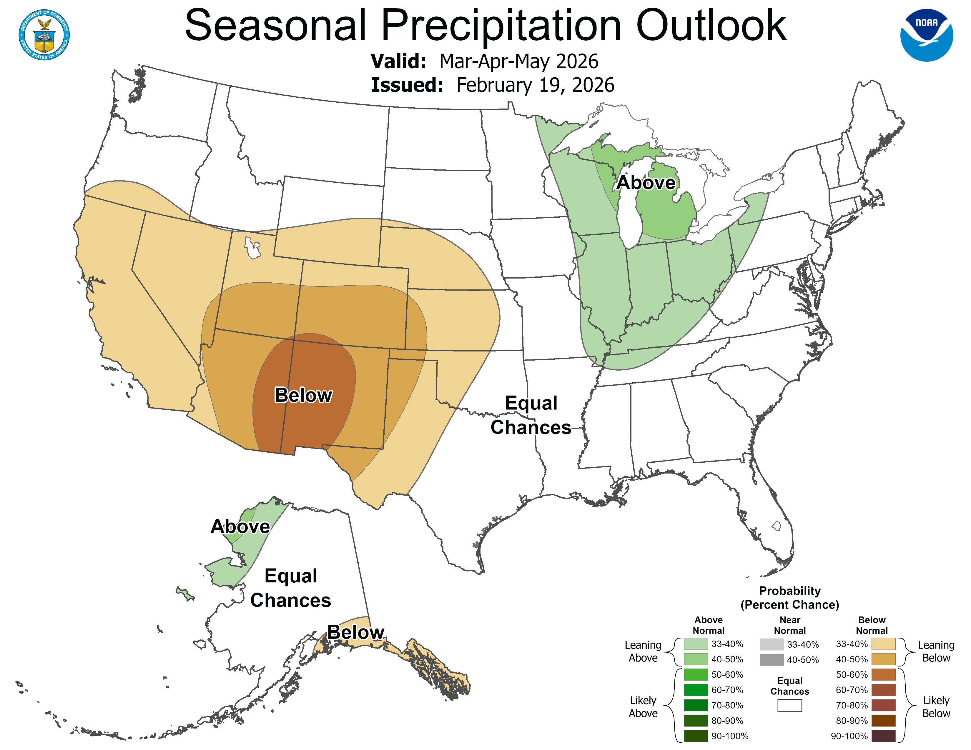
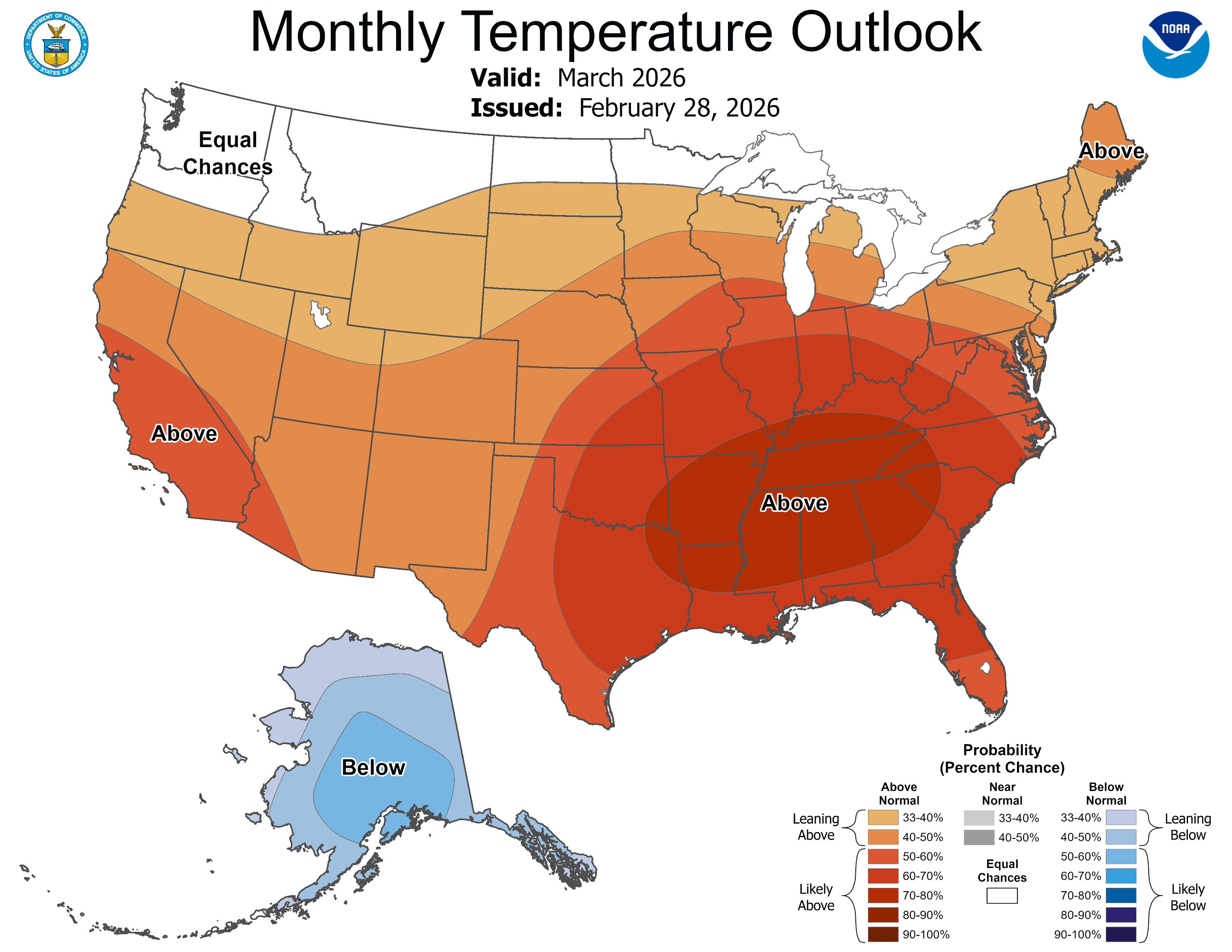
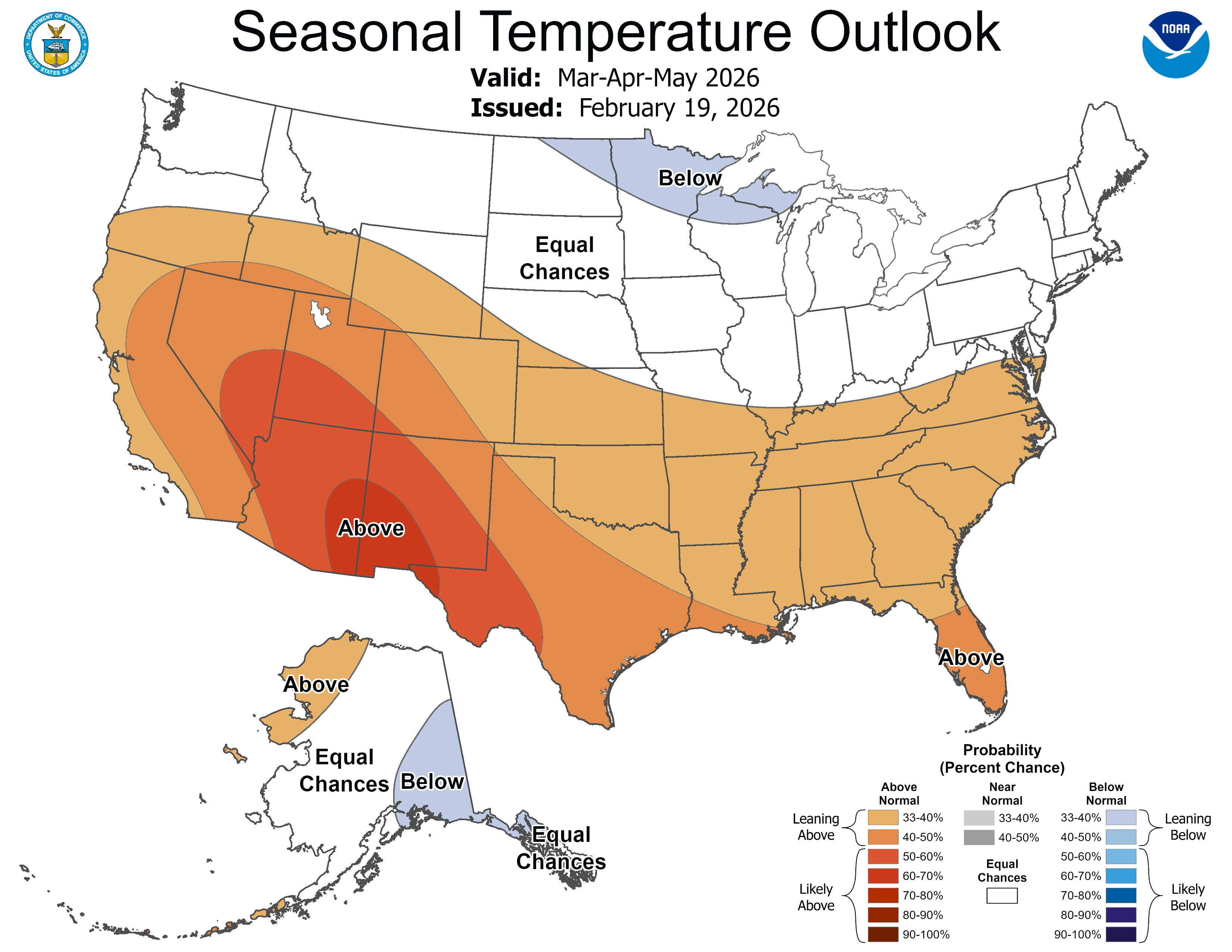
Much of the region experienced its warmest February on record, and Colorado, Utah, and Wyoming ended the season with the warmest December-February on record. As temperatures were much above average throughout the region, precipitation was below to much below average for much of the region, with record-dry conditions along the Front Range, as well as pockets in southeastern Colorado and southern Wyoming. As of March 1, snow drought continues to persist as below to much below normal snow-water equivalent (SWE) was observed for Colorado, Utah, and eastern Wyoming. Seasonal streamflow volume forecasts for regional river basins are below to much below average, except in northern Wyoming where there are near to above average forecasts. Regional drought coverage increased to 76% by early March. The NOAA Seasonal Outlooks for March-May suggest below average precipitation and above average temperatures.
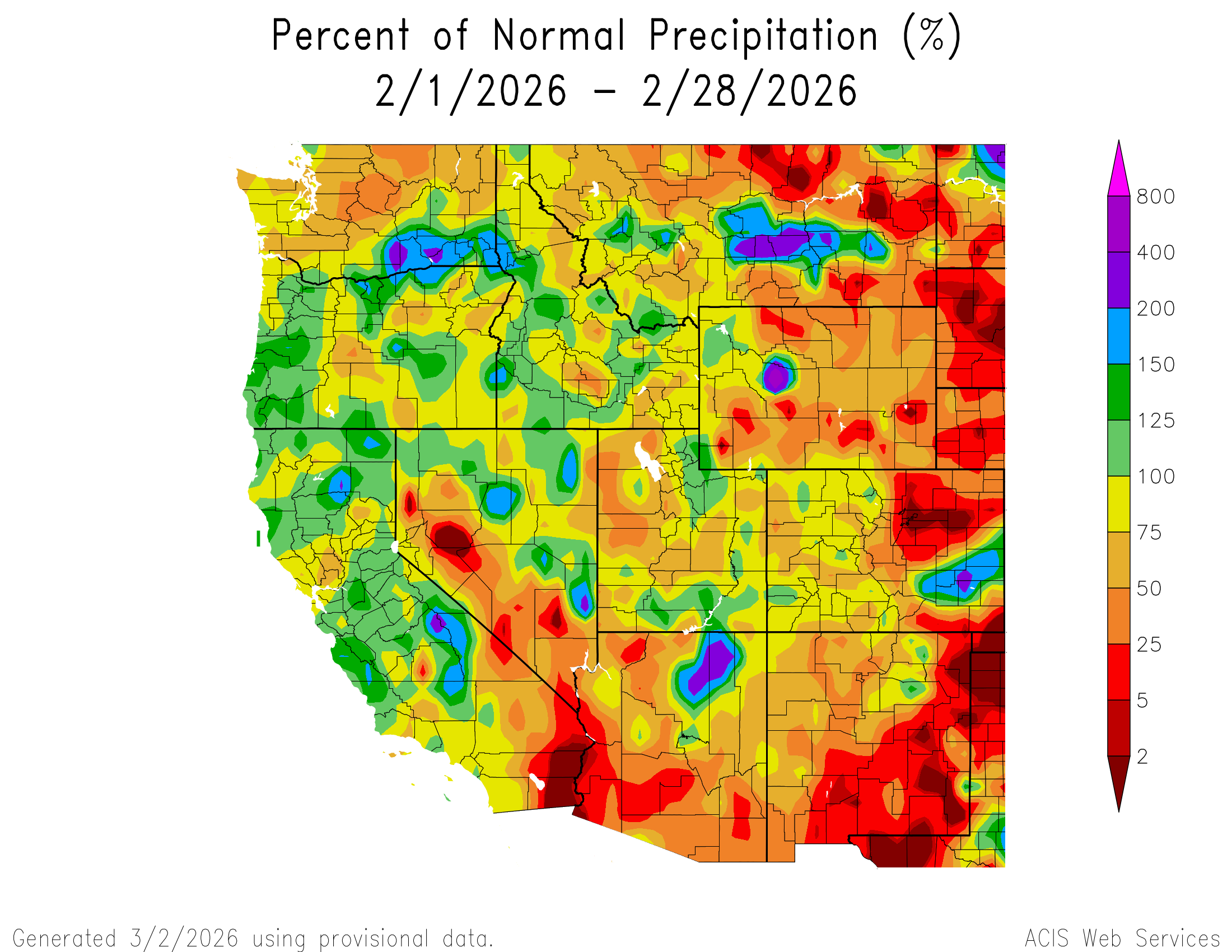
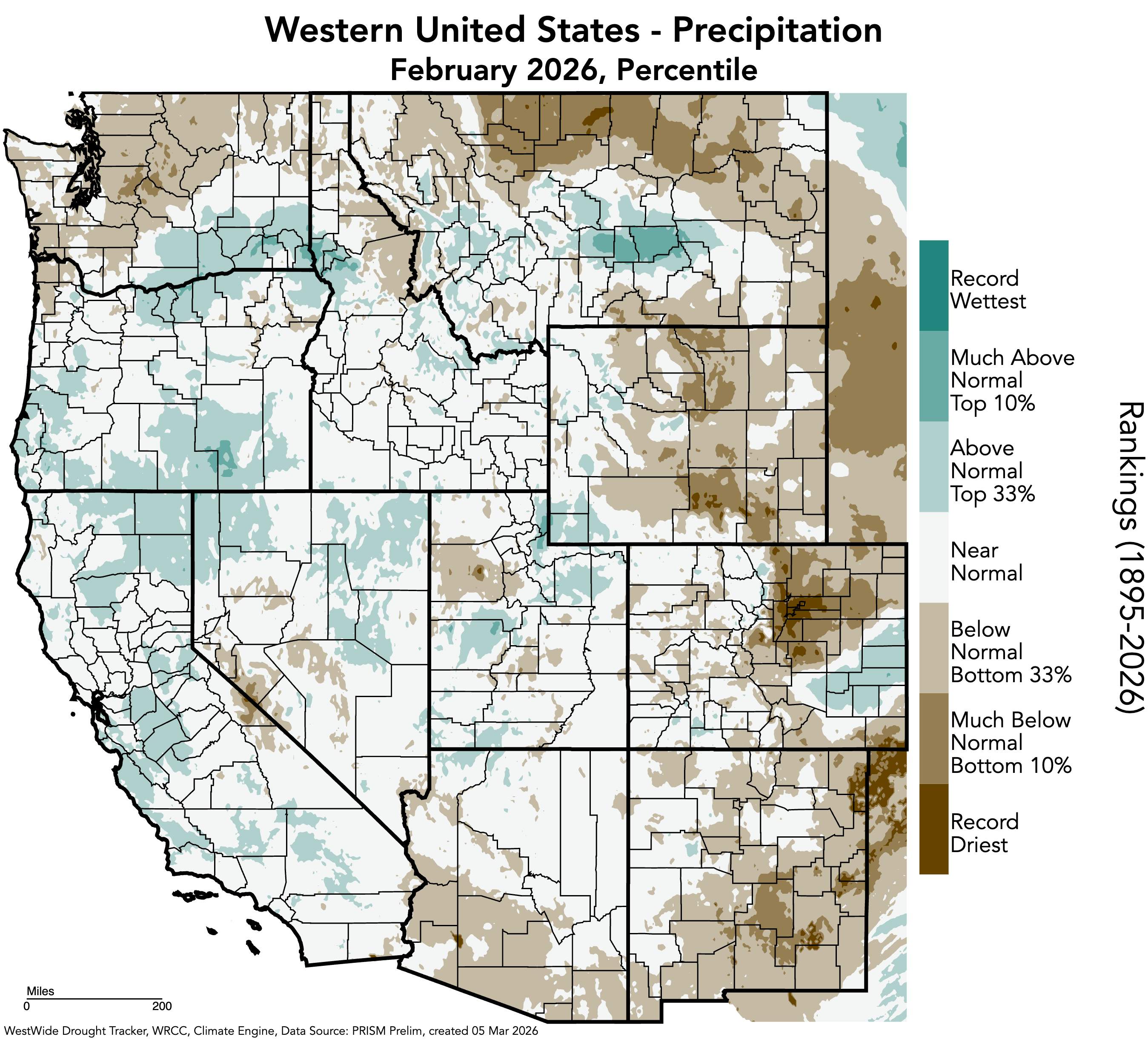
Regional precipitation was below to much below average in February, particularly in northeastern Colorado, with a large pocket of less than 2% of average conditions in Denver, Arapahoe, Adams, Washington, and Weld Counties. Another large pocket of less than 2% of average conditions occurred in southeastern Colorado in Baca County. In contrast, scattered pockets of above average precipitation occurred in each state, with two large pockets of 150-200% of average precipitation in southeastern Colorado and western Wyoming. One small pocket of 200-400% of average precipitation occurred in southeastern Colorado in Kiowa and Bent Counties, and a pocket of 400-800% of average precipitation occurred in western Wyoming in Fremont County. Record-dry February precipitation occurred in many counties along the Front Range in Colorado, including Denver, Boulder, Larimer, Jefferson, Douglas, Adams, Arapahoe, Broomfield, El Paso, Weld, and Park Counties, as well as Baca County in southeastern Colorado. Record-dry conditions also occurred in Carbon and Albany Counties in southern Wyoming, and Tooele County in western Utah.
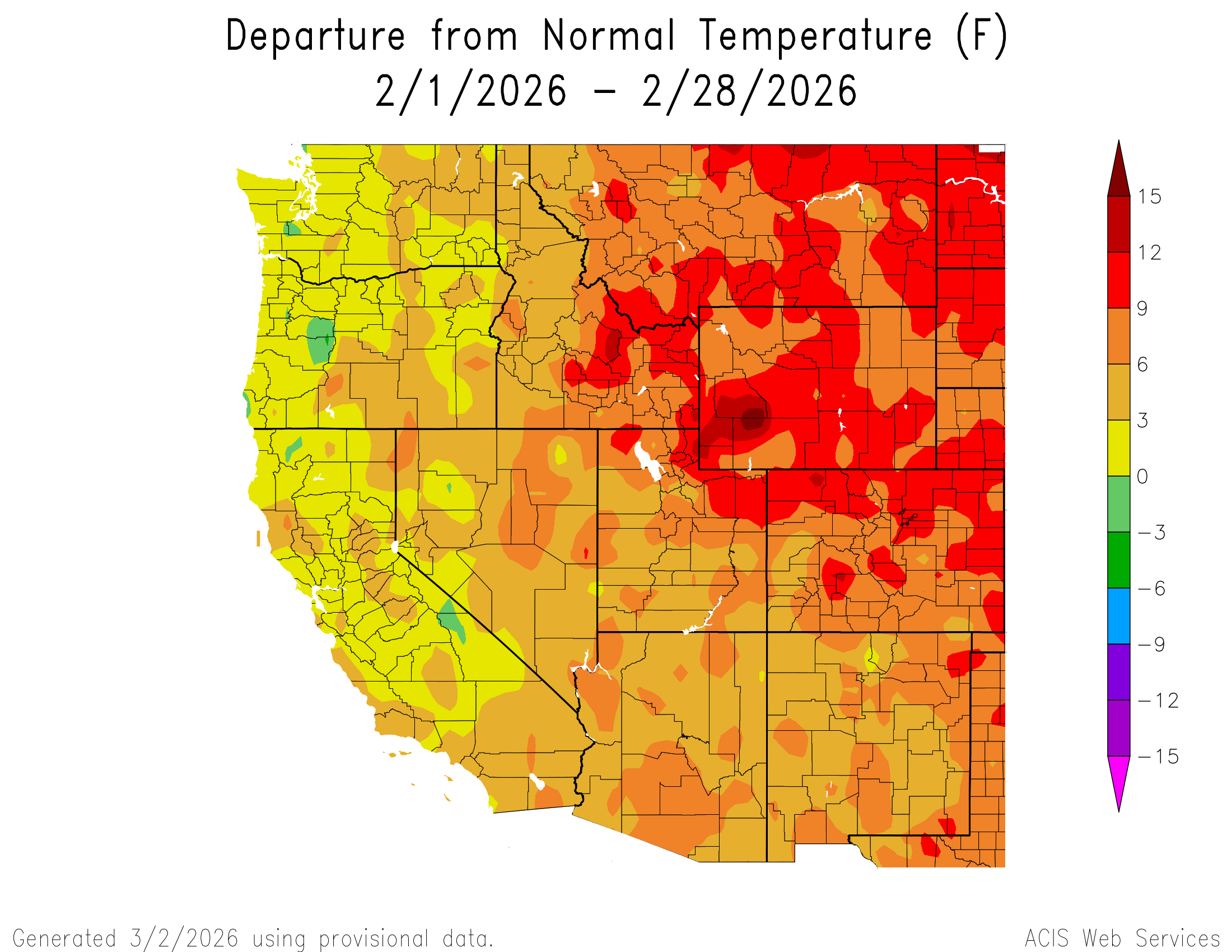
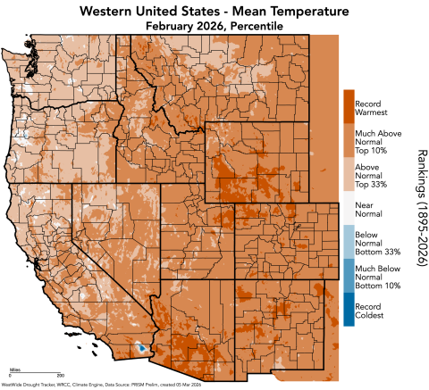
Regional temperatures were much above average to record-warm in February. Large swaths of 9 to 12°F above average temperatures occurred in each state, particularly in Wyoming and Colorado, and a large pocket of 12-15°F above average temperatures occurred in southwestern Wyoming. Colorado and Wyoming experienced the warmest February on record, and Utah experienced the third warmest February on record. All three states experienced the warmest meteorological winter (December-February) on record. These records are ranked by NOAA NCEI from 1895-2026.
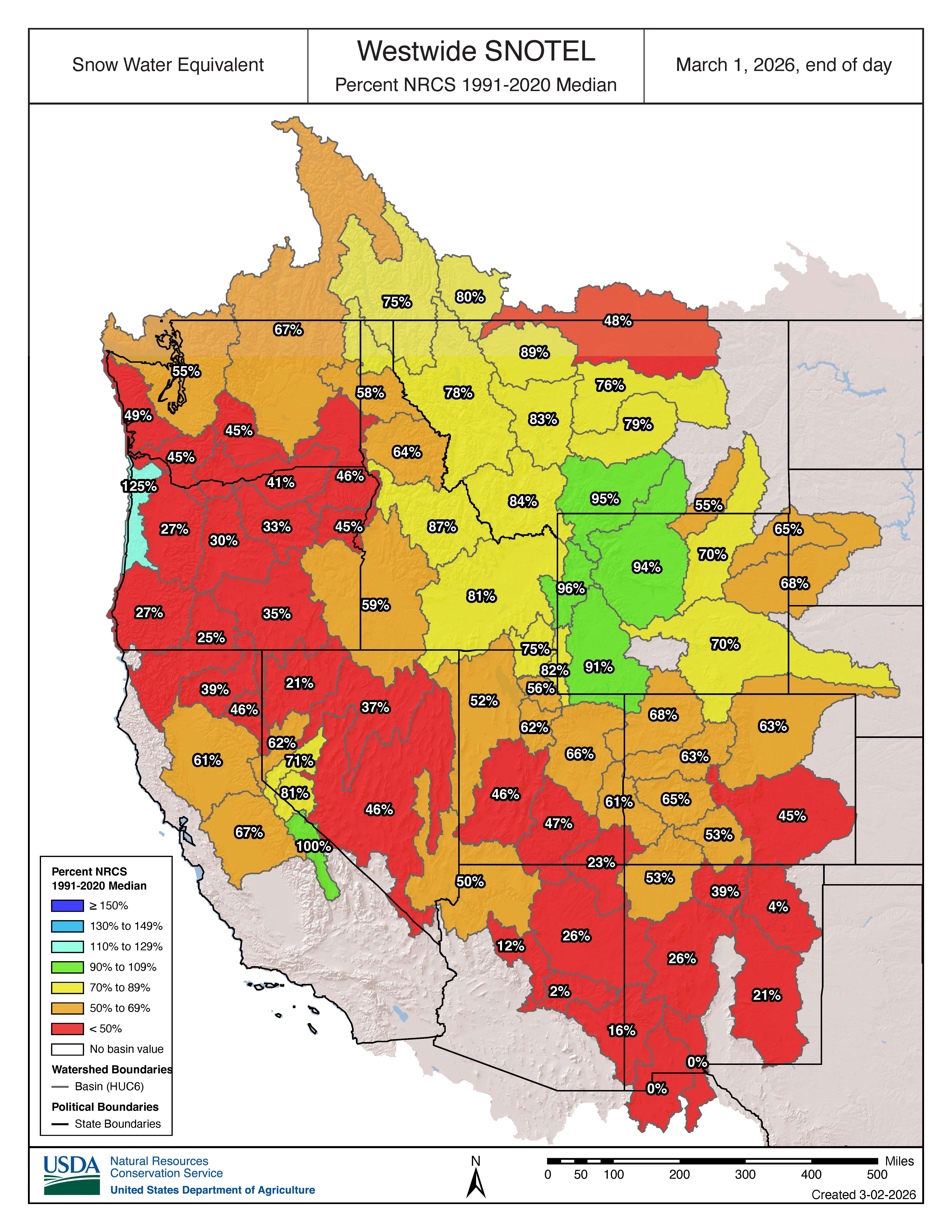
Below to much below normal snow-water equivalent (SWE) continues in Colorado, Utah, and eastern Wyoming as of March 1. River basins with 50% or less of normal SWE include the Upper Arkansas (45%) in Colorado, and the Lower Colorado-Lake Mead (50%), Upper Colorado-Dirty Devil (47%), Escalante Desert-Sevier Lake (46%), and Lower San Juan (23%) in Utah. In contrast, western Wyoming river basins have near normal SWE, including the Snake Headwaters (96%), Upper Yellowstone (95%), Big Horn (94%), and the Upper Green (91%). Due to record-warm temperatures and below average precipitation for most of the region this winter, snow drought continues to persist.
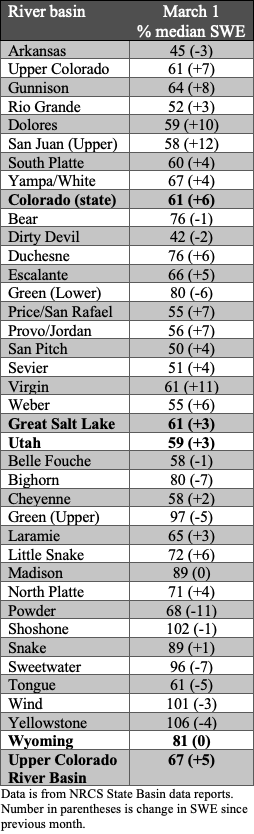
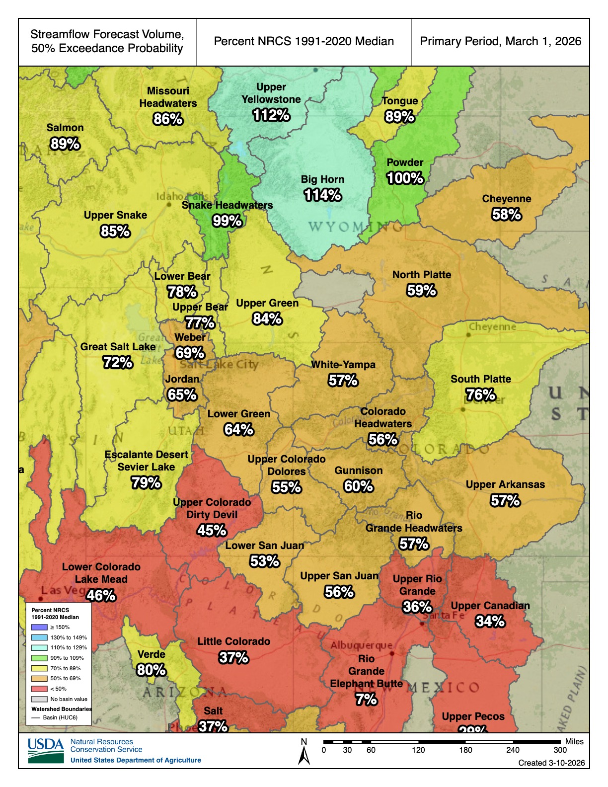
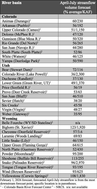
Seasonal streamflow volume forecasts for river basins in Colorado, Utah, and southeastern Wyoming are below to much below average. Near to above average seasonal streamflow volumes are forecasted for northern Wyoming. In Colorado, seasonal streamflow forecasts suggest 45-60% of average runoff for all major river basins. Runoff in most major Utah river basins is forecasted at 35-55% of average, except for the Bear River Basin (72%). Wyoming has a mix of streamflow forecasts, with below average forecasts in the Little Snake (46%), North Platte (52%), Cheyenne (57%), Upper Green (64%), and Laramie (69%) River Basins, near average forecasts in the Tongue (93%), Wind (93%), Powder (95%), and Yellowstone (108%) River Basins, and above average forecasts in the Shoshone (113%) and Big Horn (123%) River Basins. Below average inflow is forecasted for many regional reservoirs, including Lake Powell (36%), Navajo (44%), McPhee (47%), Blue Mesa (50%), Guernsey (52%), Deer Creek (53%), Scofield (56%), Deerfield (57%), and Flaming Gorge (64%) Reservoirs.
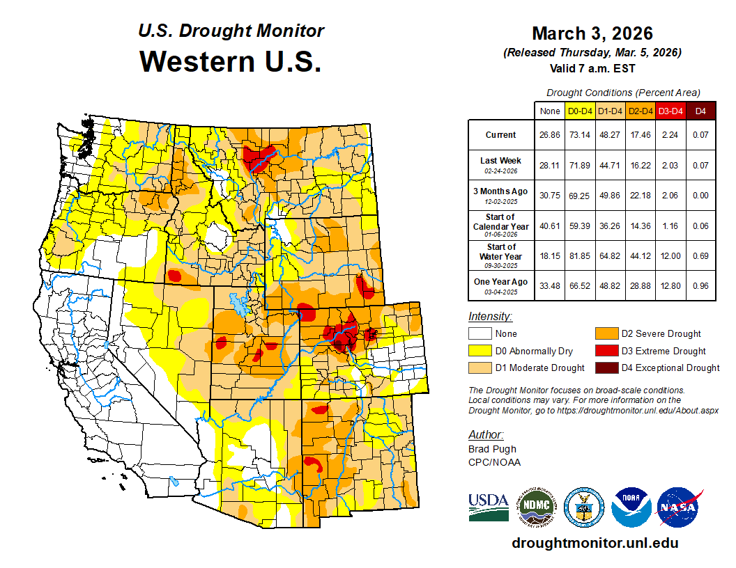
Dry and warm conditions during February caused regional drought coverage to increase to 76% by March 3 (drought covered 63% of the region on February 3). Drought conditions especially deteriorated in Wyoming, where moderate (D1) drought coverage increased by 33%, severe (D2) drought coverage increased by 14%, and extreme (D3) drought emerged in southwestern and southeastern Wyoming. In Colorado, D2 drought coverage increased by 11%, and D3 drought coverage increased by 3%, emerging in the Denver Metro region and northwestern Colorado. Utah drought coverage remained the same, with an emergence of D3 drought in northeastern Utah.
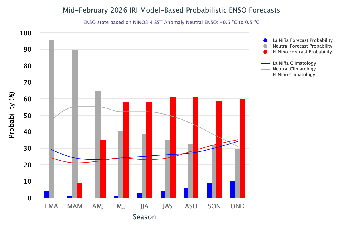
As of mid-February, La Niña conditions are declining and there is a 90% probability of transitioning to ENSO-neutral conditions during March-May. The NOAA March Precipitation Outlook suggests equal chances while the March Temperature Outlook suggests an increased probability of above average temperatures throughout the region. The NOAA Seasonal Precipitation Outlook for March-May suggests an increased probability of below average precipitation in Colorado, Utah, and southern Wyoming, and particularly in the Four Corners region. The NOAA Seasonal Temperature Outlook for March-May suggests an increased probability of above average temperatures in Colorado, Utah, and southern and western Wyoming, and particularly in southern Utah and southwestern Colorado.
Significant weather event: Extremely warm and dry winter for the Front Range. Colorado, Utah, and Wyoming experienced the warmest meteorological winter (December-February) on record, and Colorado and Wyoming experienced the warmest February on record. Colorado’s statewide average temperature for December-February was 33.6°F, surpassing the previous record of 32.0°F during the 1980-1981 winter season. Colorado’s Front Range had a particularly warm and dry February, causing extreme (D3) drought to emerge in the Denver Metro region. Denver, Adams, and Arapahoe Counties experienced their driest February on record. Denver experienced its second warmest winter on record, with an average temperature of 39.6°F, just short of the 40.1°F record from the 1933-1934 winter season. For context, the average winter temperature for Denver is 31.9°F, which this winter season significantly exceeds. Denver also experienced its driest winter, with only 13.4 inches of snow recorded by the end of February, well below the average of about 35 inches of snow for December-February. These warm and dry conditions were due to many factors, but the persistent high-pressure ridge that stayed over the western U.S. coupled with La Niña conditions was particularly notable in keeping moisture and cold temperatures out of the region.