#Drought news March 19, 2026: The Sangre de Cristo Mountains and portions of the San Juan Mountains in southern #Colorado and northern #NewMexico saw widespread worsening conditions this week

Click on a thumbnail graphic to view a gallery of drought data from the US Drought Monitor website.

Click the link to go to the US Drought Monitor website. Here’s an excerpt:

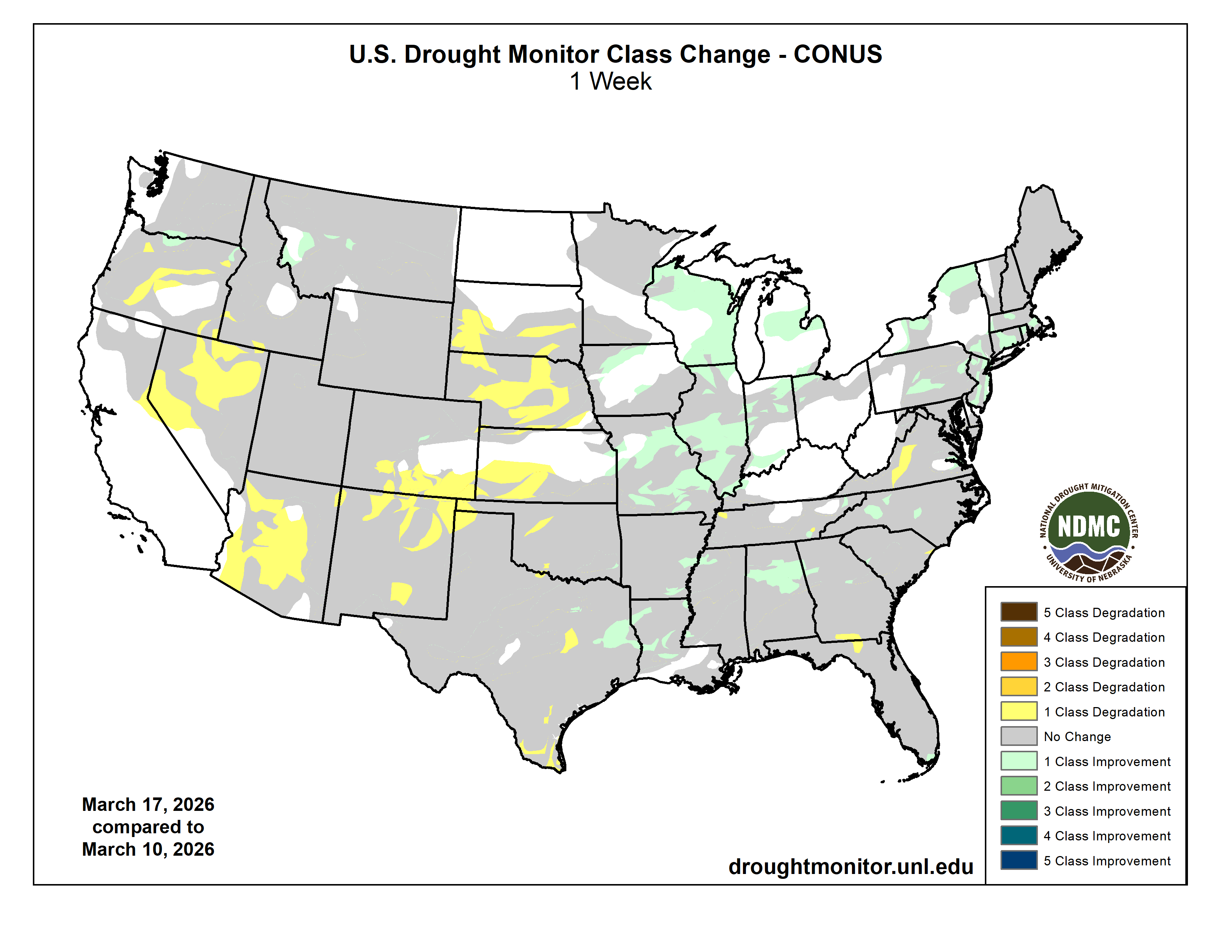
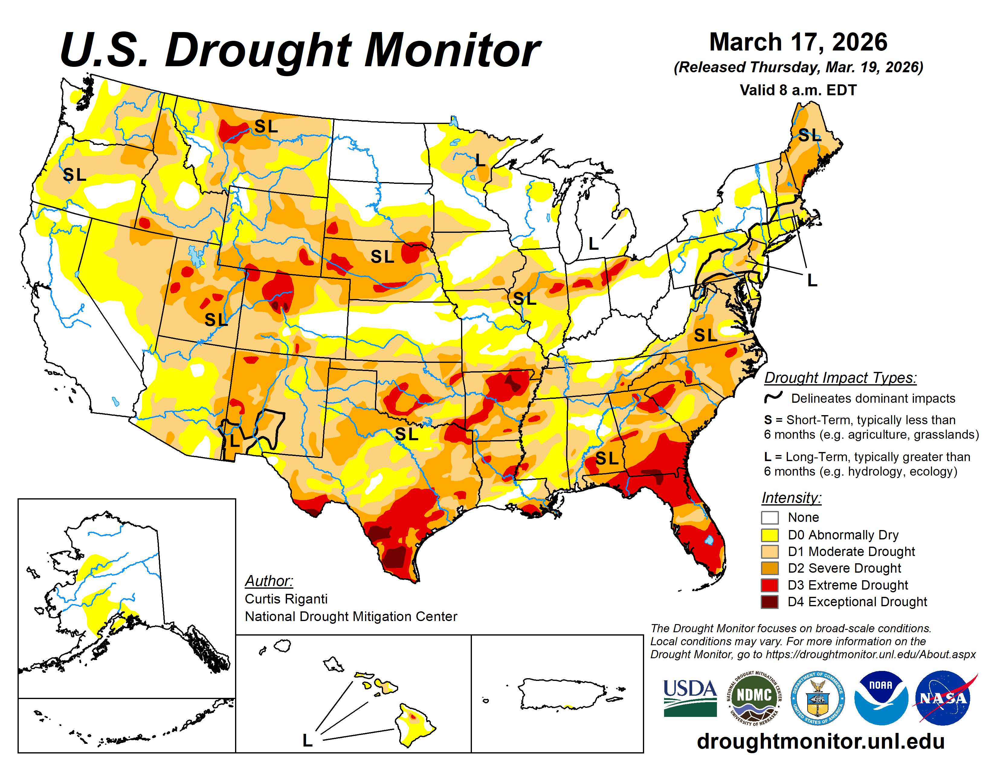
This Week’s Drought Summary

This week, a powerful storm system crossed from the Great Plains into the Great Lakes, bringing widespread rain and thunderstorms to parts of the Midwest, and a historic blizzard to portions of the Upper Midwest, especially in northern Wisconsin and Michigan near Lake Superior. Total precipitation amounts exceeded 2 inches in a large area of the western Great Lakes, while lighter amounts, mostly 0.5-3 inches of precipitation, fell across parts of the southern and eastern Contiguous U.S. Improvements to ongoing drought and dryness occurred across large portions of the Midwest, parts of the lower Mississippi River Valley, and in the Northeast outside of northern New England. Heavy rain and, in some areas, mountain snow, fell across parts of the Northwest, locally improving drought conditions. However, significant deficits in snow still exist in many parts of the West, including the Pacific Northwest, which limited the longer-term benefits of the precipitation that fell. Much of the Southwest, and the central and southern Great Plains, missed out on precipitation, and instead dealt with a dry, warm and windy week. Precipitation deficits, and lack of snowpack in the mountains, continued to worsen amid high evaporative demand, leading to widespread worsening of abnormal dryness and drought, especially in South Dakota and Nebraska, southwest Kansas, southern Colorado, New Mexico, Arizona, Nevada, and parts of Oregon that missed out on precipitation. A kona low delivered heavy precipitation to all of Hawaii this week, leading to widespread 1- and local 2-category improvements to ongoing drought conditions from Molokai eastward…
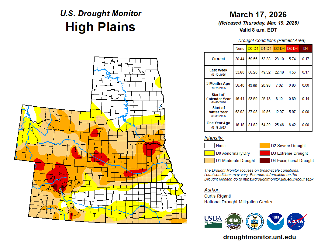
High Plains

In the southern half of the High Plains region, warmer-than-normal weather continued this week amid mainly dry and frequently windy conditions. Degradation in drought conditions was widespread across Nebraska and southern parts of South Dakota. A deadly wildfire in western Nebraska, the Morrill Fire, has burned a record amount of land for Nebraska wildfires. This fire, and others across Nebraska, occurred amid weather conditions favorable for fire growth and a background of worsening drought conditions. The Great Plains of southwest Kansas and southeast Colorado also saw worsening drought and abnormal dryness this week, as precipitation deficits continued to mount along with warmer-than-normal temperatures this winter and early spring. Large precipitation deficits and above-normal evaporative demand over the last several months led to extreme drought development in parts of the Black Hills in southwest South Dakota. Colder temperatures and some precipitation kept conditions unchanged (and mostly free of drought or abnormal dryness) in North Dakota and northern South Dakota…
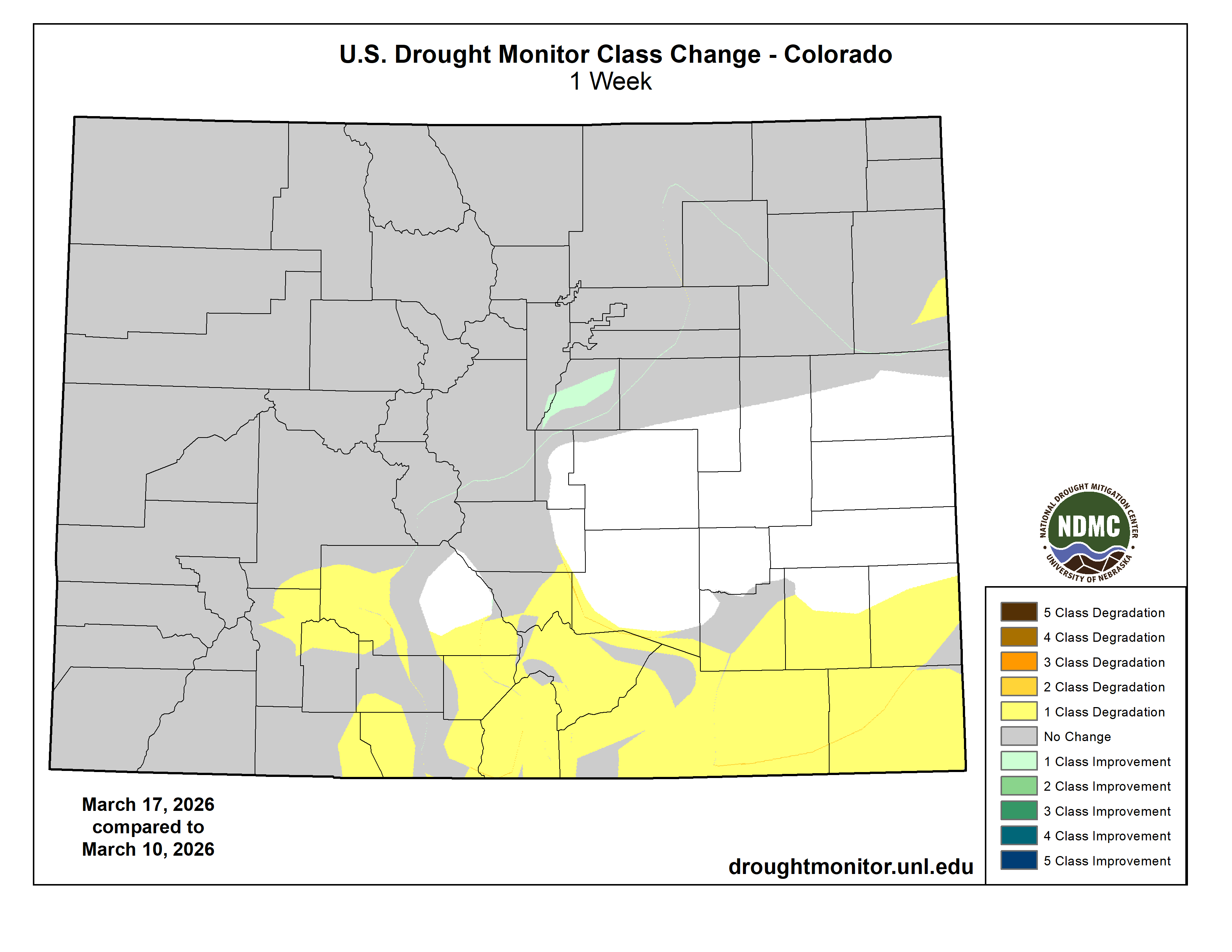
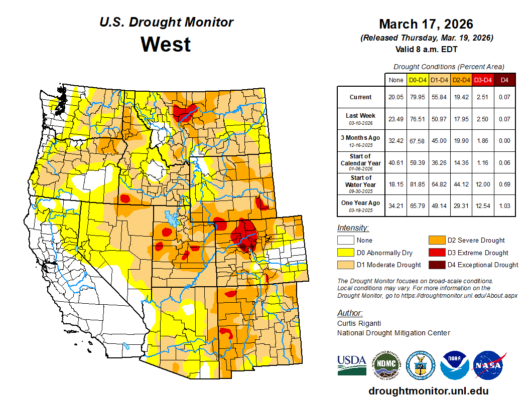
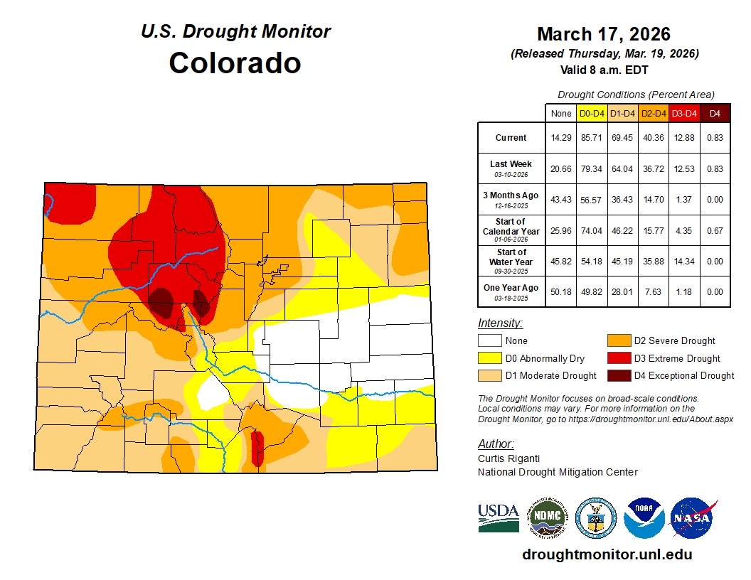
Colorado Drought Monitor one week change map ending March 17, 2026.

West

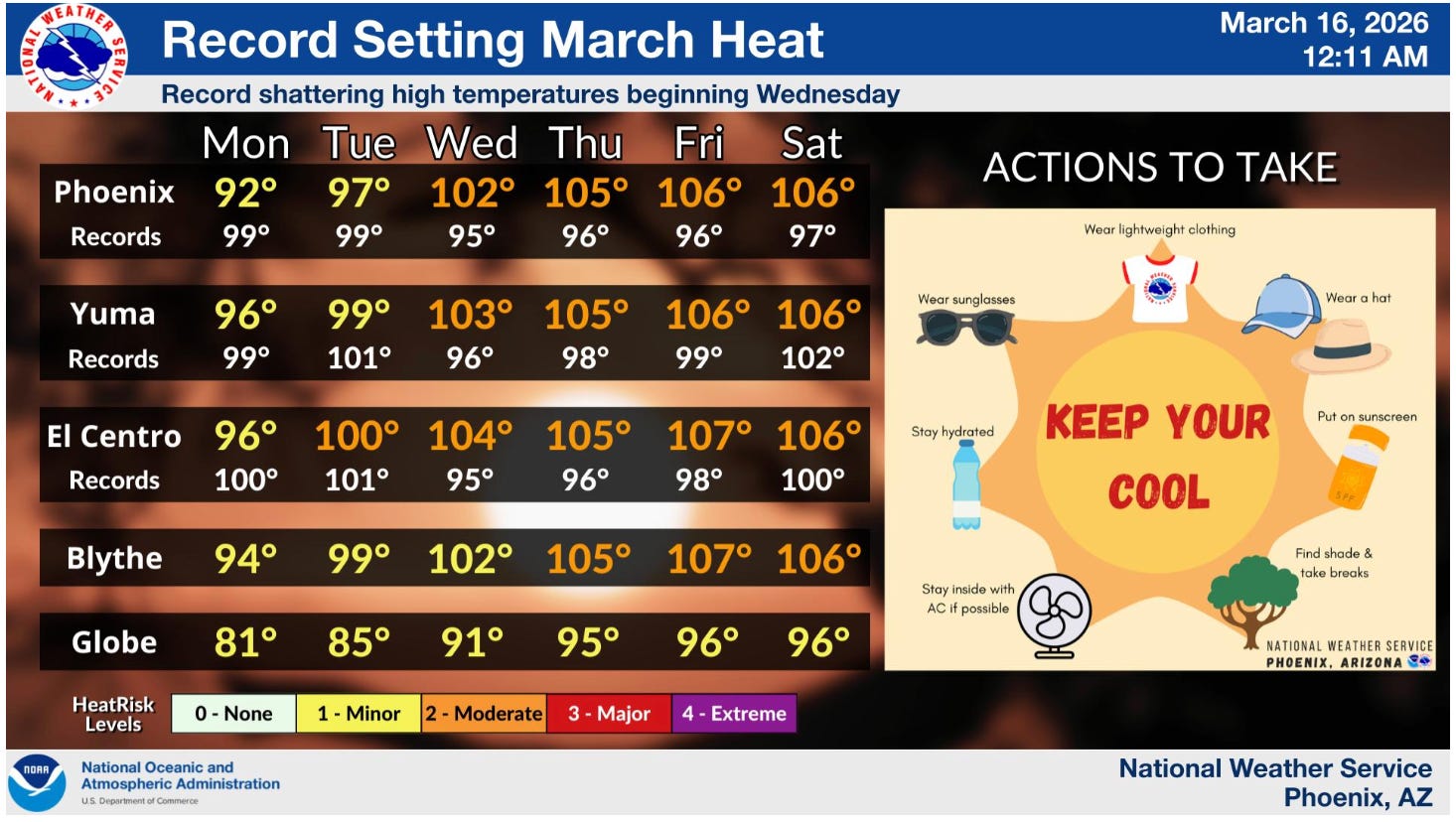
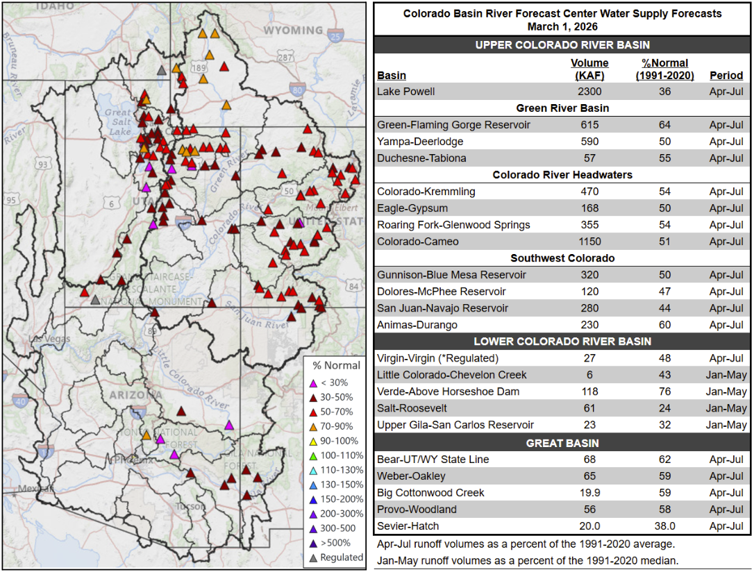
Current drought conditions in the West continued to be headlined by snow drought this week. The Sangre de Cristo Mountains and portions of the San Juan Mountains in southern Colorado and northern New Mexico saw widespread worsening conditions this week. Overall dry and warm conditions worsened both precipitation deficits and snowpack conditions in these areas. Some snow-water monitoring sites in the region have seen near-full or full melting of snowpack. Degradations to ongoing drought and dryness were also widespread in Arizona this week, where warmer-than-normal temperatures combined with dry weather to worsen short-term precipitation deficits, increase evaporative demand and support low streamflow levels. High-elevation parts of Arizona that usually have snow on the ground in mid-March are also suffering from snow drought. This combination of drier- and warmer-than-normal weather and snow drought may set the state for drought conditions to worsen in the coming weeks if weather conditions remain warm and dry. Warmer-than-normal and dry weather occurred this week in Nevada, worsening conditions in some areas, especially in the north, where impacts are being reported as a result of unusually warm and dry weather over the last several months and meagre mountain snow. Due to locally heavy precipitation or lack thereof, a mix of small-scale improvements and degradations occurred in Oregon. Amid the snow drought, localized degradations occurred in southwest Idaho, while heavier mountain snows improved snowpack in some mountain ranges in parts of western Montana, leading to localized improvements. The effectiveness of this locally renewed snowpack in improving soil moisture will be analyzed further in the weeks ahead…

South

This week, parts of east Texas, Arkansas, Louisiana, Mississippi and Tennessee benefitted from localized rains of at least 2 inches. Elsewhere, deep south Texas, western Texas, and northern and western Oklahoma were mostly dry this week. Temperatures across the region were warmer than normal, with readings varying widely from a degree or two above normal to 9-12 degrees above normal. Soil moisture levels improved and precipitation shortfalls lessened in parts of east-central Texas, Louisiana and southeast Arkansas, leading to localized improvements to drought conditions in these areas. Despite heavier rains, a small area of extreme drought shifted northeast in southeast Tennessee due to very large precipitation deficits that continued this week. Growing short-term precipitation deficits led to the development of severe drought in a small area of northwest Tennessee. Heavy rain in Dallas improved local conditions. Warm, dry and windy conditions were the rule elsewhere in the southern Great Plains and deep south Texas, leading to localized degradations in central and northern Texas, deep south Texas, south-central and northwest Oklahoma, and the Oklahoma and Texas panhandles…

Looking Ahead

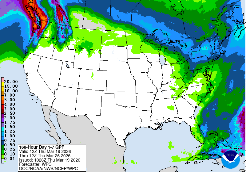
Through the evening of Monday, March 23, the National Weather Service Weather Prediction Center’s forecast depicts mostly dry weather across a large swath of the Contiguous U.S. Precipitation totaling 0.5-1 inch may fall from West Virginia into New York, and in spots in New England. Similar precipitation amounts are forecast in parts of northwest Montana and the Idaho Panhandle. Western Washington is forecast to receive widespread precipitation amounts of at least 1 inch, with some favored mountainous areas forecast to receive 2.5-5 inches of precipitation (or locally more). Elsewhere, the forecast calls for precipitation amounts to remain at or below 0.5 inches, with most of the Great Plains, Mississippi and Lower Ohio River Valleys, and the Gulf Coast states likely to remain completely dry.

Looking ahead from March 24-28, the National Weather Service Climate Prediction Center forecast strongly favors warmer-than-normal temperatures in most of the West, especially in the Southwest, and across much of the Great Plains and South. Near- or below-normal temperatures are favored from northern North Dakota eastward through the Great Lakes into much of the Northeast. Above-normal precipitation is favored in Washington, northern Oregon, the Idaho Panhandle and northwest Montana, and from northern Michigan eastward across the northern half of the Northeast. Wetter-than-normal weather is also forecast in central and southern Florida. Elsewhere in the contiguous United States, below-normal precipitation is more likely, especially from the Great Plains to Utah, Nevada, the Desert Southwest and California.

US Drought Monitor one week change map ending March 17, 2026.

Data Dump: Oak Flat land swap finalized: Plus — The Monster March Melt is upon us — Jonathan P. Thompson (LandDesk.org)

Mining mural on a wall in Superior, Arizona, the proposed site of Resolution Copper’s massive mine. Jonathan P. Thompson photo.

Click the link to read the article on The Land Desk website (Jonathan P. Thompson):

March 17, 2026

⛏️ Mining Monitor ⛏️

The U.S. Forest Service late last week completed the transfer of 2,422 acres of emory oak-studded and boulder strewn public land in central Arizona to Resolution Copper, a subsidiary of global mining corporations BHP Billiton and Rio Tinto. The newly privatized land includes Chíchʼil Bił Dagoteel, or Oak Flat, a 760-acre parcel that President Dwight D. Eisenhower withdrew from mineral entry in 1955. The land transfer removes one of the biggest regulatory obstacles blocking the company’s bid to mine a massive copper deposit that lies about one mile below the surface of Oak Flat.

Some conservation groups initially withheld opposition to the land swap because of the ecological value of the land Resolution was giving up, some of which lies along the San Pedro River, an important corridor for migratory birds. In 2015 Congress passed a bill, with bipartisan support, allowing the swap to proceed. But the company and its politician enablers failed to recognize the significance of Oak Flat to the San Carlos Apache and other tribes in the region—and underestimated the fierceness of their resistance.

Over the ensuing decade, completion of the land exchange has been held up by legal challenges and widespread opposition from Indigenous and environmental groups. Apache Stronghold, a non-profit devoted to protecting sacred sites, took its case up the legal ladder, calling on federal courts to halt the land exchange on the grounds that privatizing and destroying Oak Flat with mining and resulting subsidence would violate the Religious Freedom Restoration Act. Ultimately the Supreme Court refused to take up the case, and other legal challenges also were shot down by the courts.

The fight is not over, however. Shortly after the transfer was announced, a group of Apache women appealed to Supreme Court Justice Elena Kagan to intervene and block the exchange. Even if that fails, Resolution will still need to obtain numerous permits before it can proceed. The land exchange removes most of the project from USFS jurisdiction, leaving it in the hands of state regulators.

Because of the depth of the deposit, the mine would be underground rather than open pit, and would use the cave panel method. This may make it less visible initially, but the magnitude of the endeavor will ultimately have significant impacts on a large swath of public and private lands. As material is removed from underground, the surface will sink, or subside, creating a huge crater and destroying Chíchʼil Bił Dagoteel. Dewatering the mine workings will affect the region’s hydrology, diminishing or drying up springs and “groundwater dependent ecosystems.” And the tailings pile is expected to cover thousands of acres in Dripping Springs Wash, basically filling a desert waterway with a mountain of acid-generating, metal-laden waste.

Mining, ore processing, and slurrying operations would require large amounts of additional water. The company plans to acquire at least some of that from the Central Arizona Project, which is currently facing potentially significant cutbacks due to Colorado River water shortages.

Map showing the locations of the mine and associated facilities, along with the tailings depository (the teal and gray blob on the right side, which will totally fill in the Dripping Springs Wash valley. Source: USFS EIS.

Here are some data from the Environmental Impact Statement for Alternative 6, which was chosen in the record of decision:

  • 1.8 billion metric tons: Estimated size of the copper ore deposit under Oak Flat, one of the world’s largest.
  • The subsidence crater at Oak Flat will eventually be about 1.8 miles across and between 800 and 1,115 feet deep.

  • 1.37 billion tons: Estimated volume of tailings produced over the life of the mine
  • 20 miles: Length of slurry pipeline that would carry tailings from the ore processing facility to the Dripping Springs Wash tailings depository.
  • 4,002 acres; 490 feet: Area and height of the proposed tailings depository.
  • 9,900 to 17,000: acres of soil and vegetation expected to be disturbed. The analysis notes: “… impacts to soil health and productivity may last centuries to millennia … ”
  • 377: Number of National Register of Historic Places-eligible sites directly affected by the project.
  • The project would result in the reduction of 13,781 acres of livestock grazing leases and 2,797 animal unit months over 9 allotments, and 14 grazing-related facilities (water sources) would be lost along with infrastructure at the Slash S headquarters.
  • 87,000 acre-feet: Estimated volume of water that would be pumped from the mine (dewatering) over the project’s life. (Some hydrologists have questioned this estimate, saying it is too low).
  • Dewatering would affect 18 to 20 groundwater dependent ecosystems, i.e. springs.
  • 540,000 acre-feet: Estimated amount of water that would be pumped from the Desert Wellfield in the East Salt River valley for mining and processing operations over the life of the project.
  • 1,400; $149 million: Estimated number of full-time workers at the peak of the project and total annual employee compensation.


On a related note, I’m looking into water use at existing Arizona mines for a future Land Desk dispatch. Stay tuned. And in the meantime, if y’all have any good, reliable sources for this sort of information, I’d appreciate you sending it along to me.


🥵 Aridification Watch 🐫

Typically I wouldn’t depress you all with any snowpack/water news until early April, when mountain snowpacks typically peak, and when we should have a fairly clear picture of what we’re facing as far as spring runoff. But the Bureau of Reclamation released their projections for Lake Powell on Friday, and the heat wave that’s bearing down on the Southwest is threatening to melt whatever snow is still remaining. Without some cooler weather combined with big snows, a lot of areas may have already seen their peak snowpack, which would mean spring runoff is beginning now. 

Yikes! 

First, the Lake Powell projections. Notice that the probable minimum inflow (the red line) reaches 3,500 feet in July. Dam engineers really don’t want it going below that level (3,510 feet would be safer). And even the green line, or the most probable inflow, would drop to that point in September. Keep in mind that these projections are often over-estimates, meaning we could hit that critical level even earlier — especially given this friggin’ heat wave. And yet, the general public still has no idea how the Bureau of Reclamation might handle the situation. 

One thing you can probably bet on: The Bureau will try to buoy Lake Powell’s levels by drawing down the Upper Basin reservoirs that are in the Colorado River Storage Project. That would be Flaming Gorge on the Green River, Navajo Reservoir on the San Juan, and the Wayne Aspinall Unit (Blue Mesa, Crystal, and Morrow Point) on the Gunnison. This will, of course, affect recreation on those reservoirs as well as downstream irrigators.

And on to the heat wave. Here are some forecasts for the next few days. 


The earliest 100°F day on record in Phoenix was on March 26. That record will fall this week, along with many others, I’m sure. I mean, extreme heat warnings in March? Come on! 

Then there’s the far-less blistering, but equally concerning temperatures in the mountains. Silverton, at 9,318 feet in elevation and near the headwaters of both Colorado River and Rio Grande tributaries, is looking to have a full-on March thaw — even at night. Look at those lows for Wednesday through Friday: All above freezing. No bueno.

Oak Flat, Arizona features groves of Emory oak trees, canyons, and springs. This is sacred land for the San Carlos Apache tribe. Resolution Copper (Rio Tinto subsidiary) lobbied politicians to deliver this National Forest land to the company with the intent to build a destructive copper mine. By SinaguaWiki – Own work, CC BY-SA 4.0, https://commons.wikimedia.org/w/index.php?curid=98967960

Romancing the River: The Era of Conquest Part 2 — George Sibley (SibleysRivers.com) #ColoradoRiver #COriver #aridification #ClimateChange

Click the link to read the article on the Sibley’s Rivers website (George Sibley):

March 18, 2026

The hard news about the Colorado River since my last post here is not good; we had a storm that dropped around two feet of snow above the 8,000-foot elevation – well, maybe the 9,000-foot elevation. But that was followed by a couple weeks of ridiculously warm weather for February and early March, with more 50-degree weather forecast into the near future, and overnight lows often in the 20s, rather than down around zero. Forecasts for the runoff this year range around a third of the ‘historic normal,’ which is an increasingly meaningless number – and dangerous too, MAGA-thinking, keeping alive the hope that eventually the Colorado River will be great again if we just wait it out, or close our eyes and wish real hard, with real violence toward realists….

The Bureau bases its ‘averages’ on the recent 30-year average going by decades – so now the ‘long-term average’ is based on 1991-2020. Back as recently as 2019, it was based on the average from 1981-2010, which was more than a million acre-feet per year higher than the current 30-year average. God help us when we’re figuring in the decade of the 2020s into a 2001-2030 average – the new average would probably make this years runoff look better than it looks by the 1991-2020 average, but there’s certainly an element of delusion in that.

The ‘soft news’ about the Colorado River recently has been a declaration of ‘personhood’ for the river by the Colorado River Indian Tribes (CRIT). This is a lovely gesture by people who have been struggling for ‘personhood’ themselves for 150 years in the river’s region, and still are not quite at the table in negotiating over the river’s future, even though they have ‘used’ the river, often in fairly ‘civilized’ ways, for many hundreds if not thousands of years more than the white masters of the river.

But it seemed naive (or maybe just cynical) for the ‘lamestream media’ to ask if this declaration of personhood was going to ‘help save the river.’ We probably need to face the fact that, until we get serious about slowing down the warming of the planet, we can do nothing by way of nomenclatter to ‘help save the river’ – and even then, the best we could do would be to maintain the river where it is now, or at least not a whole lot worse – which is what’s going to happen if every year we continue to put more new greenhouse gases into the atmosphere than we did the year before. I do not see how considering the river a ‘person’ is going to change that much.

I think we should also consider that granting ‘personhood’ to another set of  living ecosystems might be kind of anthropocentric. I can barely contemplate what goes into ‘riverhood,’ for example, but watching a stream one sees a system very much engaged in interaction with its whole neighborhood – giving water to the surrounding land when the land’s water table is low, and taking on water the land can’t hold when it is wet. ‘Riverhood,’ I infer, has aspects of sharing, giving and receiving, that might have things to teach us about improving ‘personhood,’ rather than operating on the assumption that all life on the planet would love to be reduced to ‘personhood’…. Just thinking out loud, sorry.

ten tribes
Graphic via Holly McClelland/High Country News.

Our real question today is whether we can ‘save the river system’ – the structure for storage and distribution we have laid over the river – a question with which we need to actually spend some constructive time. And that kind of leads into the second part of my second ‘era’ in updating Fred Dellenbaugh’s 1903 Romance of the Colorado River: the ‘Era of Conquest.’ (First, remember, was the ‘Era of Exploration and Discovery.’)

World War II, where I left the story last post, is a natural break in the Era of Conquering the Colorado River. Prior to World War II, we saw the Bureau do its greatest work: overseeing the construction of Hoover Dam, Imperial Dam and the All-American Canal under the Boulder Canyon Project, as well as Parker Dam to back up water for the 250-mile Colorado River Aqueduct to the West Coast cities. It is hard not to call it a masterpiece of regional urban-industrial development. In our six or eight thousand-year history of humans trying to create ‘civilizations’ to constructively deal with exploding populations, the Boulder Canyon Act stands tall as a public work, fitting for a state struggling to become a mass-society democracy (possible?) rather than putting people to work on massive tombs for the self-proclaimed ‘God of the Sun’ or maybe ‘The Son of God.’

Advocates for private-sector industry will be quick to say it could not have been done without the private contractors, ‘the Six Companies’ and most notably Henry J. Kaiser. Critics of private-sector industry will be as quick to say that the private sector has not produced very many large-scale industrial organizers like Henry J – who demonstrated than you can do big work and also take good care of the people doing it. He did not rest on his laurels but capitalized on that regional system with his Fontana steel and aluminum plants and Liberty Shipyards up the West Coast.

Green Mountain Reservoir, on the Blue River between Kremmling and and Silverthorne, was built for Western Slope interests. Photo/Northern Colorado Water Conservancy District via The Mountain Town News.

The war effort cut off most domestic development – but the Bureau of Reclamation did complete two dams on the Colorado River during the war years. One was the Green Mountain Dam and Powerplant on the Blue River high in the river’s headwaters, part of the equally massive Colorado-Big Thompson Project. More about this in the next post.

The other was a modest diversion dam below Parker Dam on the Lower Colorado: Headgate Rock Dam – for the Colorado River Indian Tribes! With all the tribes in the Colorado Basin feeling – righteously – left out of river development, one might think the Bureau would make a bit of a big deal about the fact that their first Colorado River project completed after the Boulder Canyon Project was a diversion dam for irrigating Indian agriculture. Yet I can find none of the usual historical and statistic evidence in the Bureau websites about the Headgate Rock Dam, like they have for all of the other Colorado River projects, each getting its own website. Possibly this is because the operation of the dam was turned over to the Bureau of Indian Affairs Office after construction was finished.

It is, however, an interesting story. The tribes along the river were farming like Nile Valley Egyptians, planting in the new layer of silt laid down annually by the snowmelt floods, crops that needed little further irrigation. That worked until the federal Indian agents started moving Hopi and Navajo bands onto their reservation in the 1860s – the reservations truly were ‘concentration camps,’ forcing the move to ‘civilized’ agriculture. This had moved the Indian agents to acquire some pumps round the turn of the century, to water land beyond the riparian floodplain. But when the gates on Hoover Dam were closed in the mid-1930s, that ended the annual snowmelt floods, also ending the traditional agricultural economy.

So the Bureau plotted out a gravity-flow diversion dam and canal in 1938, and began construction. But construction did not really accelerate until 1941, when in one of America’s most shamefully hysteric events 17,000 Japanese-Americans were ‘relocated’ to the Colorado River Indian Tribes (CRIT) reservation – undeniably a concentration camp at that point, if only for the concentration of people. But that added not just a lot of hungry mouths, but a proven workforce that joined the First People in working on the Headgate Rock Diversion Dam and the canal works to carry the water.

It would be both insensitive and naive to speak of a ‘happy ending,’ but as the interred Japanese did in many of the desert places they were sent to, their concentration camp became a very livable village system; some stayed on after the war, and today there is a memorial monument and periodic celebration commemorating the positive relationship that developed between two ‘unwanted peoples’ – the uprooted Japanese and the Indians who forcibly shared their homeland. A story that, for some reason, the Bureau is not interested in telling….

Meanwhile, however, the Bureau was not lying dormant. Immediately after the war’s end, the Bureau released what amounted to a smorgasbord of opportunities, under the title The Colorado River: A Natural Menace Becomes a National Resource. This proposed 134 possible projects for the development of the entire river basin for human uses – cautioning that there was not enough water in the river to build them all, thereby intruding the good old all-American element of interstate competition. Fifty-eight of those proposed projects were for the Lower Basin states, but the other 88 were for the Upper Basin states. If the pre-war Colorado River development had all been about the Compact’s Lower Basin states, the post-war development would begin with controlling the ‘natural menace’ in the Upper Basin states and putting the water to work.

The 1946 Bureau report divided the Upper Basin into three different divisions, based on the River’s three main tributaries above the canyons: there were 33 projects for the Green River Division out of Wyoming and Colorado but flowing mostly (but not entirely) through eastern Utah; 35 projects for the ‘Grand Division’ (the Upper Colorado-Gunnison Rivers, originating in Colorado but flowing into Utah (using the older name for the Upper Colorado); and 20 projects for the San Juan Division, most of whose tributary waters flowed out of Colorado’s San Juan Mountains but the river itself flowed mostly through northern New Mexico and southern Utah.

The Little Snake River is about to join the Yampa River on Oct. 8, 2020. Photo credit: Allen Best/Big Pivots

An obvious challenge lay in the absence of any coordination between those natural divisions of the Upper Basin and the geographically-irrelevant state boundaries. Every major tributary except for the Gunnison River crossed at least one state boundary. The Little Snake River in the Yampa River Basin is the extreme example, crossing the Colorado-Wyoming border seven times.

Grand River Ditch in Rocky Mountain National Park. Photo credit: Greg Hobbs

Nonetheless, the first task for the Upper Basin, before the Bureau could go to work, was to divide the use of the waters among the states in an Upper Colorado River Basin Compact. This task was made the more difficult because the state boundaries bundled the relatively water-rich Upper Colorado River Basin with other drier river basins – the Platte, Arkansas and Rio Grande rivers in Colorado, Wyoming and New Mexico; and the Great Basin in Utah. And water law – plus fervent belief in big-project technology – accommodated the notion of moving water from one river basin to another. The Grand Ditch from high on Colorado’s West Slope to the Poudre River on the East Slope was already being dug by the turn of the century. Unlike water for either agricultural or municipal uses within a basin, nothing flows back into the basin of origin from a transmountain diversion – a total depletion.

The task of dividing the use of the Upper Basin waters was also complicated by vague writing in the Colorado River Compact – Article III(d), stating that ‘the States of the Upper Division will note (sic) cause the flow of the river at Lee Ferry to be depleted below an aggregate of 75,000,000 acre feet for any period of ten consecutive years.’ Was this a caution to the Upper Basin states to make sure their uses did not start cutting into the Lower Basin’s shares? Or was it a mandate to those states to deliver that much water even if it meant cutting their own uses – essentially turning the Compact into a ‘senior water right’ to the Lower Basin?

This was not really foreseen as an issue in 1922, with a river that early 20th-century optimism assumed would run at around 18 million acre-feet (maf) forever. But after the drought of the 1930s and the middling flows of early 40s, plus the mid-war treaty with Mexico to deliver 1.5 maf across that border every year, it was evident to the Upper Basin state negotiators, who gathered in 1946 to work on an Upper Basin Compact, that the river might not always produce the 7.5 maf the Compact promised to them. Their preferred interpretation of the Compact’s Article III(d) would obviously be the ‘cautionary’ interpretation – don’t be the cause of the river flow declining. But they also knew that California and Arizona would interpret it as a ‘mandate’ – and since Congress would have to ratify their Compact, they chose to not ‘waken the bear,’ as California’s current governor would put it.

So rather than dividing the use of the Upper River’s hoped-for allotment of 7.5 maf in four set figures, like the Lower Basin has, they chose to divide it into percentages: 51.75% for Colorado (which provides around 70% of the river’s water), 23% for Utah, 13% for Wyoming, and 11.25% for New Mexico. They also chose to calculate their usage by their depletions of a stream’s flow rather than adding up consumptive uses, as the Lower Basin does. I will not pretend to know exactly how this works – except to note that a measure of depletions by users also includes evaporation and transpiration, while the Lower Basin’s measures allows such considerations to get lost in their calculations of usage. (The Bureau calculates Lower Basin evaporation and transpiration on a separate spreadsheet from recorded uses.)

Meanwhile, however -…  Don’t you just love it when a writer intrudes ‘Meanwhile, however’ into an already complicated mess?  This is my secondmeanwhile in this post, so it is probably time to give you a break, with only a teaser about the next step in this growing ganglia of complexity.

While the still somewhat beloved Bureau of Reclamation, creator of Hoover Dam and the New West, was just cranking up the mill for the development of the rest of the Colorado River Basin waters, the Upper Basin states had already been working out their separate peace over the transmountain diversion issue between the wet Colorado River basins of origin with low populations, and drier basins of destination with large populations across the mountains. This is a story that goes back to the 1930s, with the ‘New Deal’ federal government putting out large amounts of funding for public projects in all the states – but with the caveat that for any state to tap into that funding, the whole state had to want the project…. Stay tuned for the next thrilling episode in The West’s Romance with Conquest.

Colorado transmountain diversions via the State Engineer’s office