Click the link to read the article on the Colorado State University website (Russ Schumacher):
March 25, 2026
Each day during the winter and spring, one of the first things I look at is the U.S. Department of Agriculture’s website that shows the current status of the snowpack in Colorado’s mountains.
Maybe that sounds like the strange habit of a state climatologist, but I’m far from the only one. Why? Because the snow that falls in our state’s mountains will, when it melts in the spring and summer, become a large portion of the water supply for tens of millions of people.
Those people aren’t only here in Colorado, but are in other states, Tribal nations, and Mexico, drawing their water from the rivers that originate in Colorado. Mountain snow is essential for our winter recreation industry, for farms and ranches that grow our food, for drinking water, for ecosystem health, and much more.
It hasn’t been a pretty sight when I have opened that USDA website each morning this winter. In an average year, our mountains get a lot of snow: In places like the Park Range, the West Elk Mountains or the San Juans, a typical year brings hundreds of inches of snow, carrying more than 40 inches of liquid water. This year, we struggled to get half that. Now, after an unprecedented heat wave in March, the snow is already disappearing quickly.
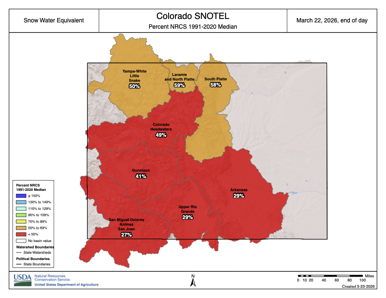
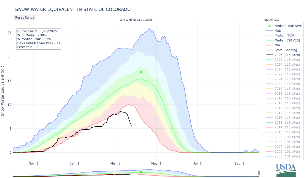
As of March 25, averaged across 115 stations in Colorado’s mountains, the snow water equivalent was just 38% of the 1991-2020 average. (The snow water equivalent is the amount of water stored in the snowpack.) This represents the lowest snowpack in more than 40 years – and possibly ever – in Colorado’s mountains. Conditions haven’t been any better along the Front Range and Eastern Plains, which have also lagged far behind the average amount of snowfall.
There have been other major snow droughts in the past, notably the winters of 1976-1977 and 1980-1981, that threatened the ski industry and resulted in record-low streamflow on some of Colorado’s rivers. But this snow season has been unrivaled in its warmth. The first five months of the water year – from October through February – were Colorado’s warmest on record by a large margin. And it’s almost certain that we are in the midst of the warmest March on record as well.
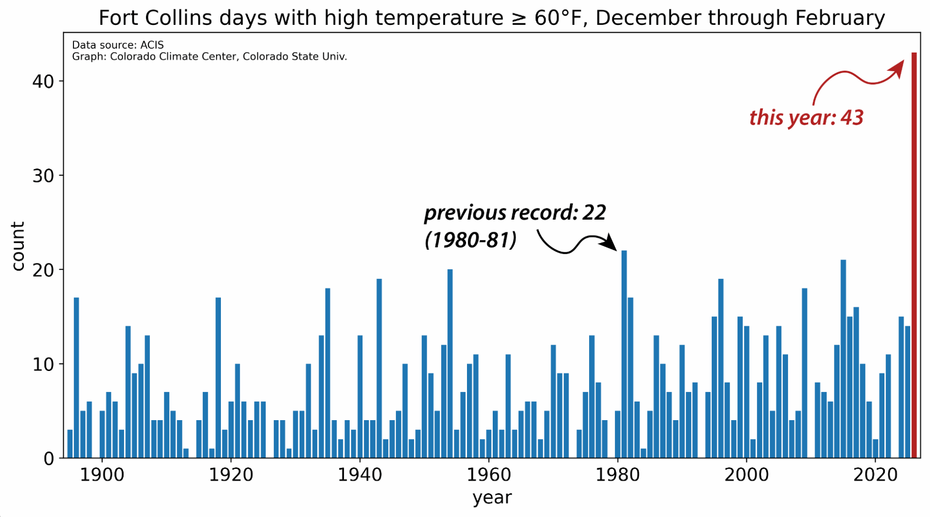
The warmth has been remarkably persistent, as relentless ridges of high pressure have prevented the usual snowstorms from moving into the state. The Fort Collins weather station at Colorado State University recorded an astonishing 43 days with a high temperature of 60°F or above during climatological winter (December through February). The previous record, from records dating back to the late 19th century, was 22. Starting March 18, Fort Collins had temperatures higher than had ever been observed in March, four days in a row. This was capped by a high of 91°F on March 21; there had never previously been a 90-degree day in Fort Collins before May.
Records for March were smashed across the state and the western U.S., at both low and high elevations. One thing we do as state climatologists is put current conditions into historical context, as usually with some investigation, it’s possible to find a past analog to what we’re experiencing now. But the intense and prolonged heat has been unlike anything previously observed in March.
This, of course, is occurring in the context of a long-term trend toward warmer conditions, both globally and locally, largely attributable to increases in greenhouse gases. Per data from the National Oceanic and Atmospheric Administration, nine of the 11 warmest years in Colorado records have occurred since 2012, and Colorado has now warmed by 3°F since the 1890s. Droughts come and go, and they have always been a challenge in Colorado and the West. But warming is making them more likely and more intense. In other words, climate change is water change.
When above-average temperatures and precipitation deficits stack up over the course of months, we start to see drought conditions develop or worsen. The impacts of drought are wide-ranging and include economic and agricultural repercussions. Farmers and ranchers may face lower crop yields and higher costs of feeding livestock. A snow drought like this winter’s can reduce outdoor recreation opportunities and hurt the state’s tourism industry. Drought years also tend to be years with more and larger wildfires.
Drought impacts can be felt a long distance from where the precipitation deficits occur. For example, southeastern Colorado received decent precipitation this winter, but low snow in the mountains hundreds of miles away near Leadville means less water on the Arkansas River, an important source for farmers in southeastern Colorado.
As each winter progresses, even if the mountain snowpack isn’t looking great, we can always look ahead to March and April as the time when big storms are possible and the deficits can be made up. Unfortunately, this year has been just the opposite: Instead of much-needed snowstorms, we’re in an unprecedented March heat wave that is accelerating the melting of what little snow is there. The chances of getting back into the range of average have dwindled away, and if the weather pattern doesn’t turn around in April, we may be headed for uncharted territory for Colorado water.