Click the link to read the article on the Colorado Climate Center website (Allie Mazurek):
March 26, 2026
Last week’s heat wave was record-smashing, extraordinary, and impossible to ignore. Given that temperatures were more typical of what we’d expect in June, we’ll try not to judge you if you felt the need to turn on your A/C. 🙂
In this blog post, we’ll provide some climate context on last week’s mind-boggling temperatures and touch on the current drought and snowpack situation. And while we’ll focus on the heat from last week here, it’s worth noting that yesterday, March 25, featured yet another round of record-breaking temperatures across Colorado, including new March high temperature records in Denver (87°F) and Grand Junction (88°F).
Widespread, eye-popping warmth
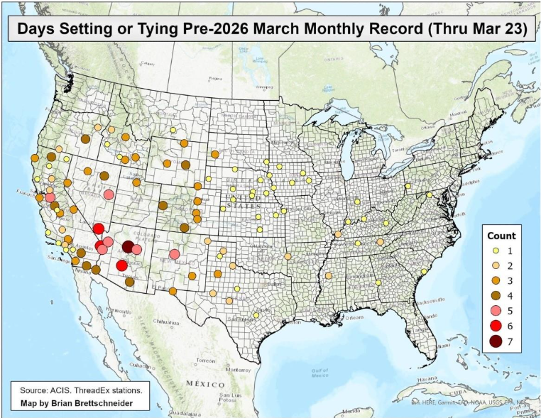
For pretty much all of Colorado, last week brought the warmest March temperatures ever recorded. There were far more stations in the state that broke all-time monthly high records for March than did not. Here’s a look at the records that were set at some of our long-term climate sites:
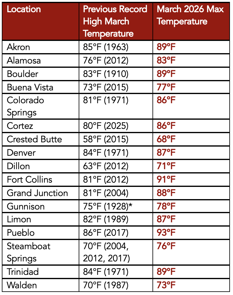
From the [table] above, you’ll see that we didn’t just break previous monthly records by a small margin; new records were set by several degrees. It would be noteworthy to have new daily climate records were set by these kinds of margins, but to see monthly records shattered by more than 5°F across numerous stations is truly remarkable.
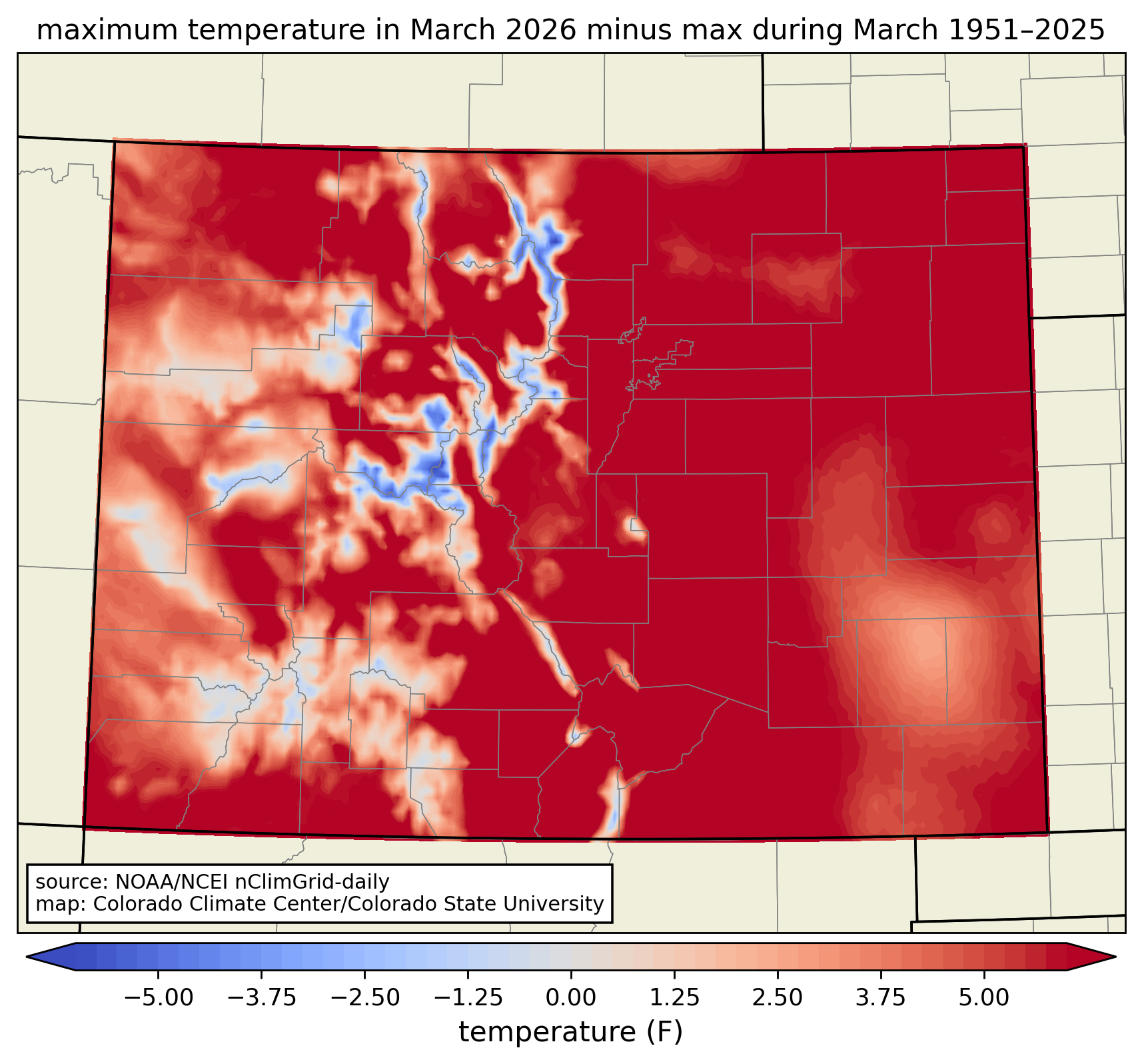
Another way of looking at this is by comparing the highest temperature observed this March (through the 22nd) to the highest temperature observed in all Marches from 1951—2025 in a gridded temperature dataset (in this case, NOAA’s nClimGrid). Nearly the entire state is red, meaning this March broke the previous record over this time period. (The main exception is at the highest elevations, where it was slightly warmer in March 1987.) Furthermore, most of the state saw temperatures at least 5°F higher than had previously been seen in March. The all-time March record for Colorado of 96°F at Holly in 1907 was not broken, but was tied at numerous locations including La Junta, Burlington, Campo, and Walsh.
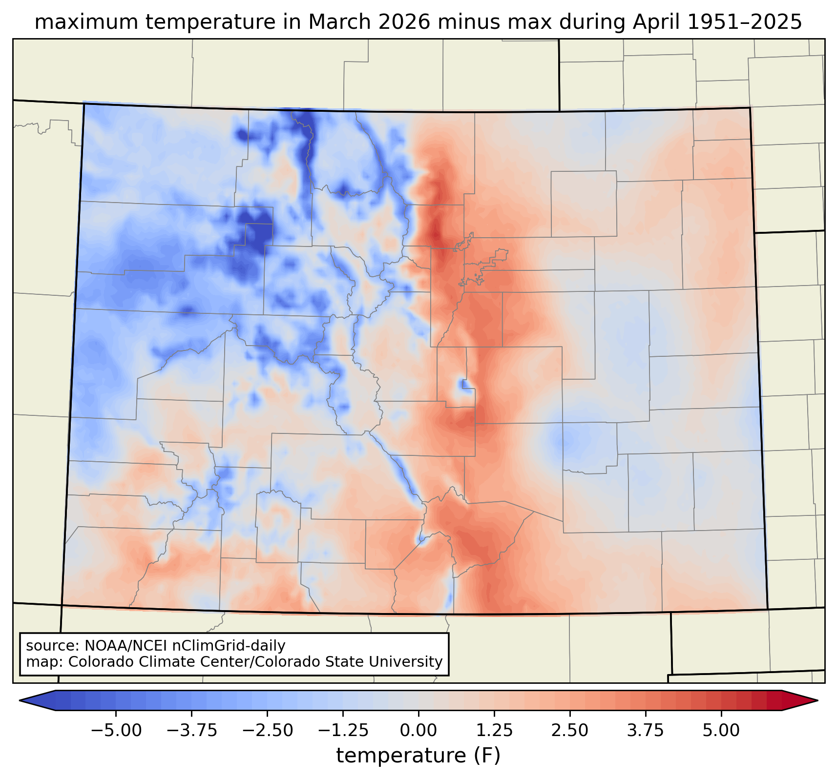
To put an even bigger exclamation point on these incredible records, there were several places in Colorado that not only set new all-time records for March, but they also saw warmer temperatures than their all-time records for April. This includes places like Alamosa (new March record of 83°F; current April record is 80°F) and Fort Collins (new March record of 91°F; current April record is 89°F). Comparing last week’s temperatures to records since 1951, you’ll notice that most of the Front Range Urban Corridor, San Luis Valley, and lower elevations in southeastern Colorado saw warmer temperatures than any March or April day in the past 70+ years:
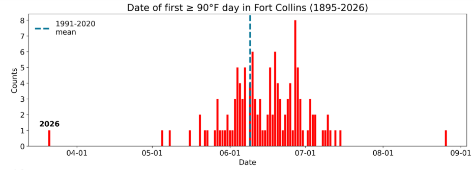
As you might expect, the kind of heat that we saw last week across Colorado is more typical of June or even July. In Fort Collins, the reading of 91°F on March 21 marked Fort Collins’s earliest 90°F or warmer day (the previous record was May 5, set back in 2000). On average, Fort Collins doesn’t see its first 90°F or warmer day until June 15:
Last week’s heat was not only remarkable in terms of intensity but also longevity. The most significant heat occurred across four days (March 18-21). Over that period, several locations set new monthly records every one of those days, with each day being warmer than the last. This was a common theme throughout much of the western US:
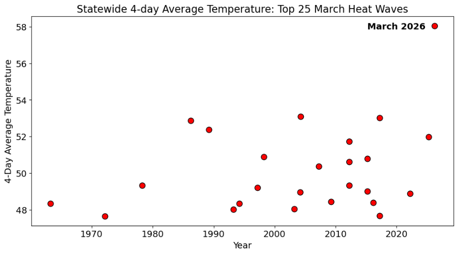
In Colorado, this long-lasting, remarkable heat was far beyond anything we’ve seen in March. Comparing last week’s heat to previous March “heat waves” (defined as days with the warmest 4-day averaged temperatures), it was a step far above the rest. Statewide averaged temperatures during March 18-21, 2026 period were nearly 5°F warmer than Colorado’s 2nd-warmest March heatwave (March 23-26, 2004):
Snowpack is rapidly declining
One of the most concerning consequences of last week’s is the impact to our snowpack. If you’ve been following along throughout the winter, then you’re well-aware that Colorado has been seeing its worst snowpack in at least 45 years. And the very warm conditions over the past week have exacerbated an already bad situation.
Looking at the statewide water-year-to-date snowpack in the SNOTEL network, it’s clear that snow water equivalent has taken a massive nosedive over the past week or so. On average, Colorado’s peak snowpack date is April 7, meaning that we should still be seeing snowpack accumulate in late March. Instead, averaged over the state, snow water equivalent has declined by over 2.5 inches in the last week. We typically don’t see snowpack melt this quickly until May, so to observe this trend so early in the season is highly concerning.
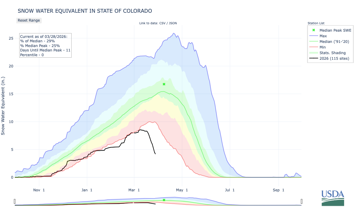
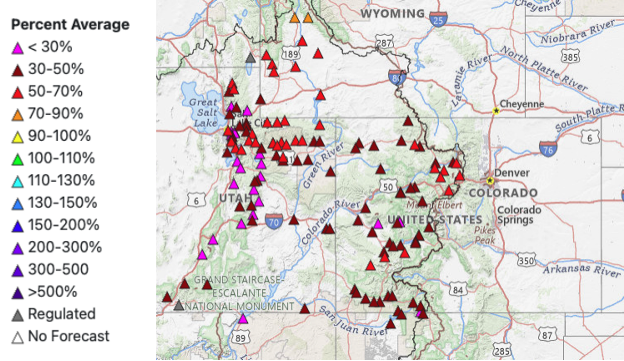
Statewide snowpack currently sits at [29%] of the 1991-2020 median. Given the current conditions and forecasts, it’s very possible that many locations have already seen their peak snowpack. Every major river basin in the state is running way-below average, with 71 of the 92 active SNOTEL stations reporting their lowest values on record:
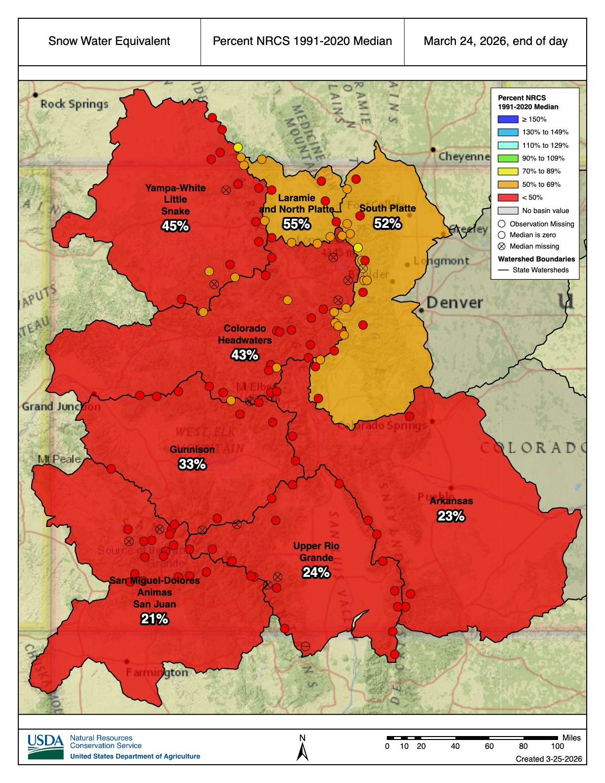
In a previous blog post, we discussed that a combination of SNOTEL data (dating back to the 1980s) and manual snow measurements (dating back to the 1930s) have been used to evaluate how this year’s snowpack stacks up against past winters. Throughout much of the winter, the story has been that this year’s snowpack is very bad, but it hasn’t been quite as bad as the winters of 1976-77 and 1980-81. However, with last week’s rapid early season melting, conditions have deteriorated further. We’ll wait for official confirmation from snow course data at the end of the month, but current data suggests that we’re now sitting at Colorado’s worst snowpack on record, surpassing the winters of 1976-77 and 1980-81.
Drought conditions are deteriorating
When discussing the drought landscape, all eyes have been on the major snow deficits in Colorado’s mountain areas, but that isn’t the only part of the state that’s been seeing worsening drought conditions. Most of Colorado’s lower elevations have also seen substantial precipitation deficits in recent months. As such, drought conditions throughout the state have worsened and expanded over the past few months.
Per the latest US Drought Monitor, approximately 91% of the state is experiencing at least abnormally dry conditions, and ~74% of Colorado is experiencing drought (D1 or worse). Those numbers have increased from 54% and 45%, respectively, since the start of the water year on October 1, 2025. The recent warmth brought particularly large changes to the drought monitor last week, as Colorado’s exceptional drought or worse area (D3 or higher) nearly doubled from ~13% last week to ~24% in the latest drought monitor.

Consequences from the low snowpack are growing
Impacts from this year’s low snowpack are increasing as governments agencies and industries that rely on it are beginning to respond and plan for additional effects. The expanding drought (in part due to the low snowpack) has prompted the Colorado Governor’s Office to activate the State Drought Task Force for the first time since 2020. Utility departments and water managers have begun to initiate drought response plans and implement water restrictions. And ski areas are planning to close earlier than expected due to poor conditions. Unfortunately, as we anticipate well-below average runoff this spring, impacts will likely expand further.
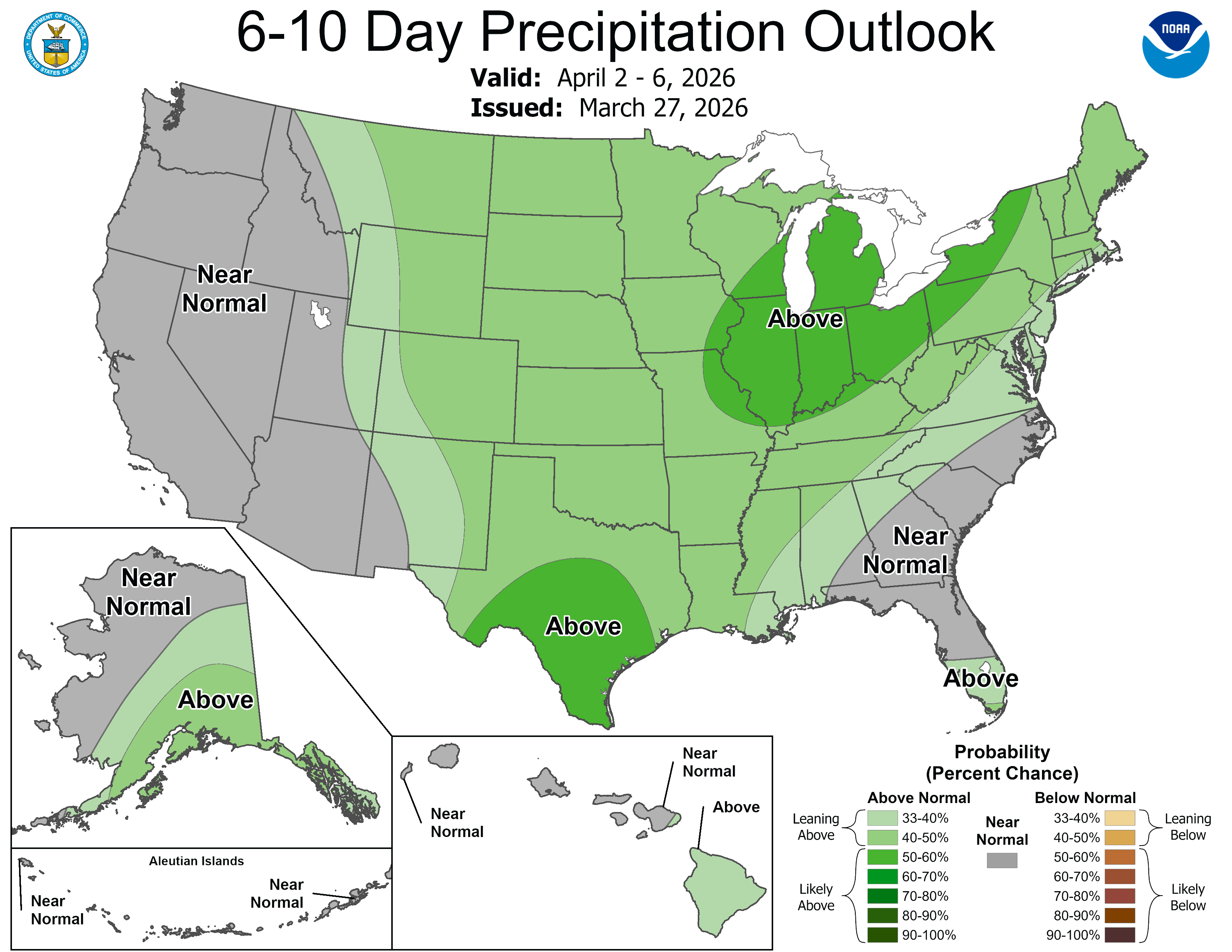
The one piece of potential good news that we’ll end this post with is a pattern shift is likely in early April, which is expected to bring precipitation chances to Colorado. While the moisture won’t be nearly enough to make up for the major deficits we’ve seen accumulate over the last several months, I think we can all agree that we’ll take anything we can get.