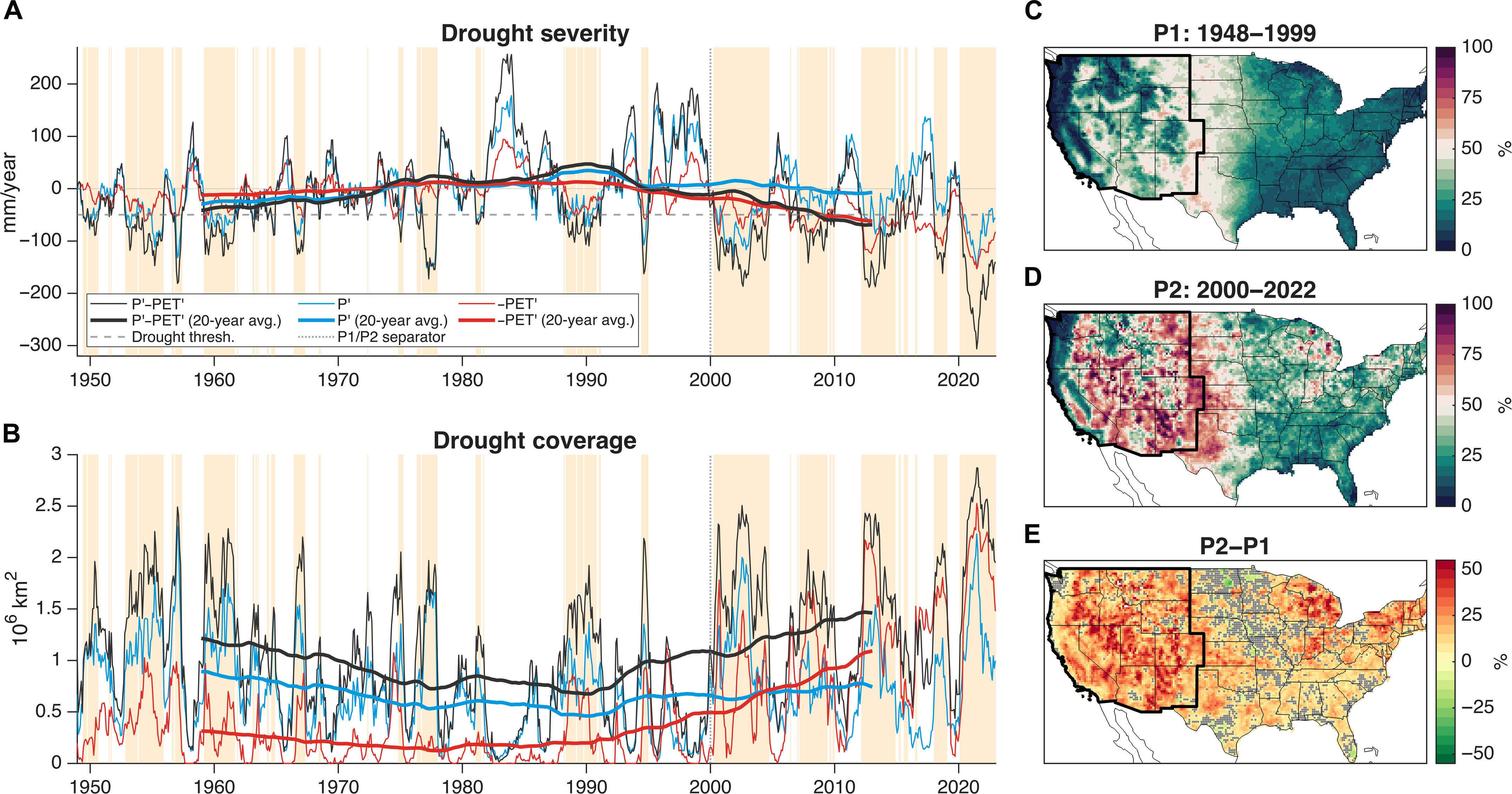
Fig. 1. Contributions of P′ and PET′ to the WUS drought. (A) Drought severity time series of 12-month moving cumulative P′−PET′, P′, and −PET′ during 1948–2022 averaged over the WUS (with cosine latitude weighting); the thin lines represent 12-month cumulative values, while the thick lines are their 20-year moving average; the yellow-shaded area represents drought periods identified when average P′−PET′ falls below its 30th percentile value for the 1948–1999 climatological period (marked by the gray dashed horizontal line); the vertical dotted line separates 1948–1999 (P1) and 2000–2022 (P2). We multiply PET′ by −1 for direct comparison with P′. (B) Time series of drought coverage and contributions from P′ and −PET′; thin lines represent total areas within the WUS (11 contiguous US states, 3.12 × 10⁶ km2 in total) that are in drought condition (local P′−PET′ below the 30th percentile value for any grid point; black) and those where PET′ (red line) or P′ (blue line) alone was strong enough to cause drought (Materials and Methods); thick lines are their 20-year moving average. (C) Map of averaged PET′ contribution to drought severity, i.e., −PET′/(P′−PET′), during drought periods in P1; the thick black line marks the boundary of the WUS region. (D) Same as (C), but for drought periods in P2. (E) Change of PET′ contribution from P1 to P2, i.e., the difference between (D) and (C); gray dotted areas indicate insignificant change (P ≥ 0.05; P values are adjusted using the false discovery rate (FDR) criterion of αFDR < 0.05).
Historically, meteorological drought in the western United States (WUS) has been driven primarily by precipitation deficits. However, our observational analysis shows that, since around 2000, rising surface temperature and the resulting high evaporative demand have contributed more to drought severity (62%) and coverage (66%) over the WUS than precipitation deficit. This increase in evaporative demand during droughts, mostly attributable to anthropogenic warming according to analyses of both observations and climate model simulations, is the main cause of the increased drought severity and coverage. The unprecedented 2020–2022 WUS drought exemplifies this shift in drought drivers, with high evaporative demand accounting for 61% of its severity, compared to 39% from precipitation deficit. Climate model simulations corroborate this shift and project that, under the fossil-fueled development scenario (SSP5-8.5), droughts like the 2020–2022 event will transition from a one-in-more-than-a-thousand-year event in the pre-2022 period to a 1-in-60-year event by the mid-21st century and to a 1-in-6-year event by the late-21st century.
Udall/Overpeck 4-panel Figure Colorado River temperature/precipitation/natural flows with trend. Lake Mead and Lake Powell storage. Updated through Water Year 2024. Credit: Brad Udall
As observed by the Gravity Recovery and Climate Experiment (GRACE) and GRACE Follow On (GRACE-FO) missions, global terrestrial water storage (TWS), excluding ice sheets and glaciers, declined rapidly between May 2014 and March 2016. By 2023, it had not yet recovered, with the upper end of its range remaining 1 cm equivalent height of water below the upper end of the earlier range. Beginning with a record-setting drought in northeastern South America, a series of droughts on five continents helped to prevent global TWS from rebounding. While back-to-back El Niño events are largely responsible for the South American drought and others in the 2014–2016 timeframe, the possibility exists that global warming has contributed to a net drying of the land since then, through enhanced evapotranspiration and increasing frequency and intensity of drought. Corollary to the decline in global TWS since 2015 has been a rise in barystatic sea level (i.e., global mean ocean mass). However, we find no evidence that it is anything other than a coincidence that, also in 2015, two estimates of barystatic sea level change, one from GRACE/FO and the other from a combination of satellite altimetry and Argo float ocean temperature measurements, began to diverge. Herein, we discuss both the mechanisms that account for the abrupt decline in terrestrial water storage and the possible explanations for the divergence of the barystatic sea level change estimates.
Article Highlights
Global terrestrial water storage, excluding glaciers and ice sheets, declined abruptly between May 2014 and March 2016, with a corollary increase in sea level
A series of droughts, possibly linked to global warming, has since helped to prevent global terrestrial water storage from recovering
Also around 2015, two independent estimates of barystatic sea level began to diverge, but we find no evidence of a connection with the terrestrial water storage decline
Illustration of the NASA’s Gravity Recovery and Climate Experiment Follow-On (GRACE-FO) spacecraft, which will track changes in the distribution of Earth’s mass, providing insights into climate, Earth system processes and the impacts of some human activities. GRACE-FO is a partnership between NASA and the German Research Centre for Geosciences.
Credits: NASA/JPL-Caltech
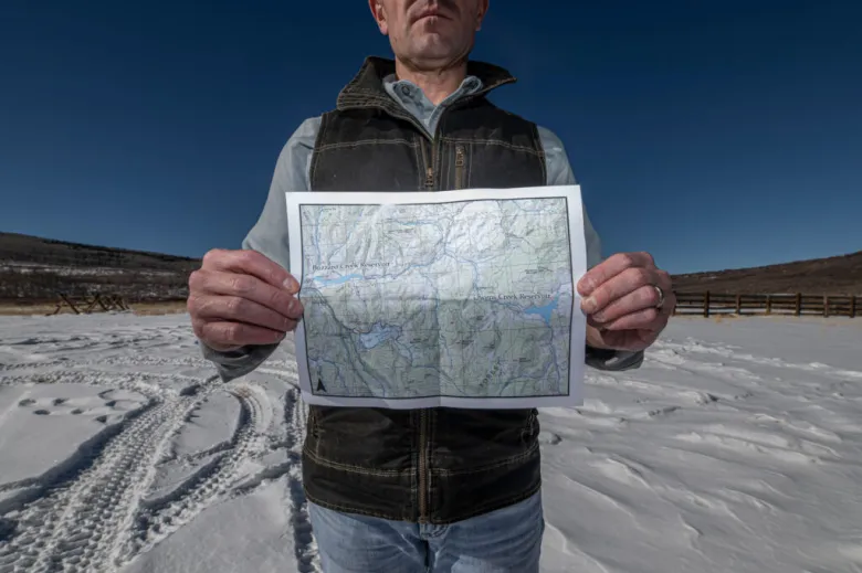
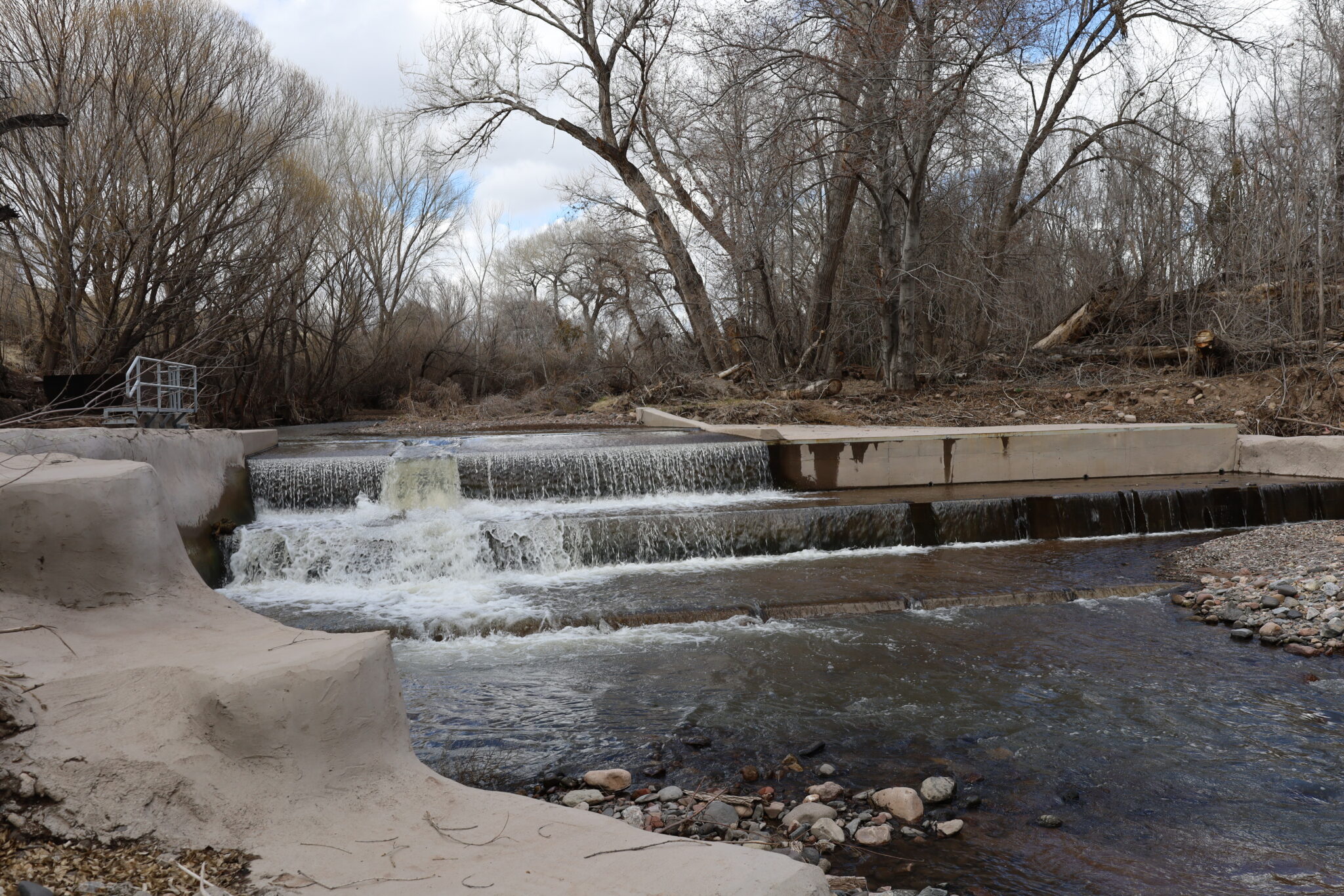
he site where Ute Water plans to build Owens Creek Reservoir at 8,200 feet on the Grand Mesa was snow covered by mid-November. The Western Slope’s largest domestic water supplier has conditional water rights for the 7,000-acre-foot reservoir. Credit: William Woody
Click the link to read the article on the Aspen Journalism website (Heather Sackett) Be sure to click through for the great graphic showing conditional water rights volumes and locations:
Updated December 18, 2024 to include William Woody’s photographs (Used with permission).
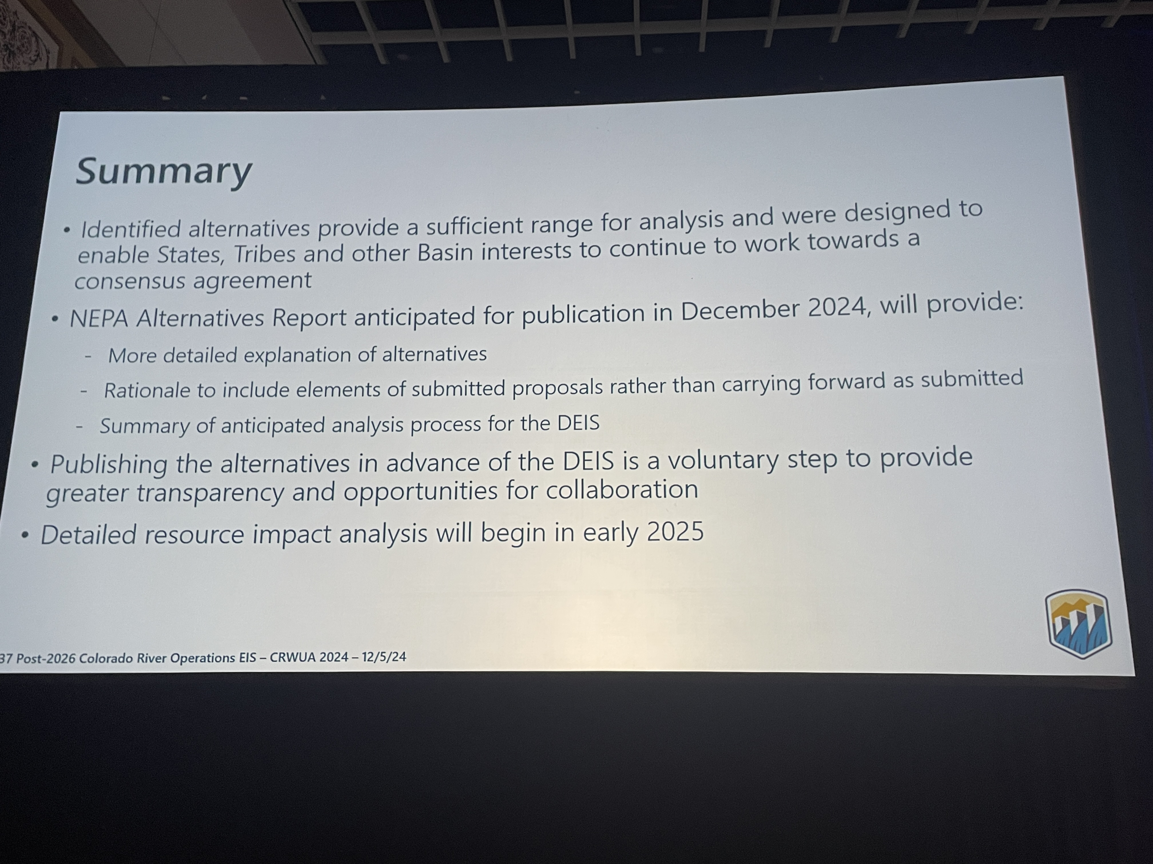
December 12, 2024
Cities, conservancy districts, energy companies own rights for 2.6 million acre-feet of additional water storage on the Western Slope.
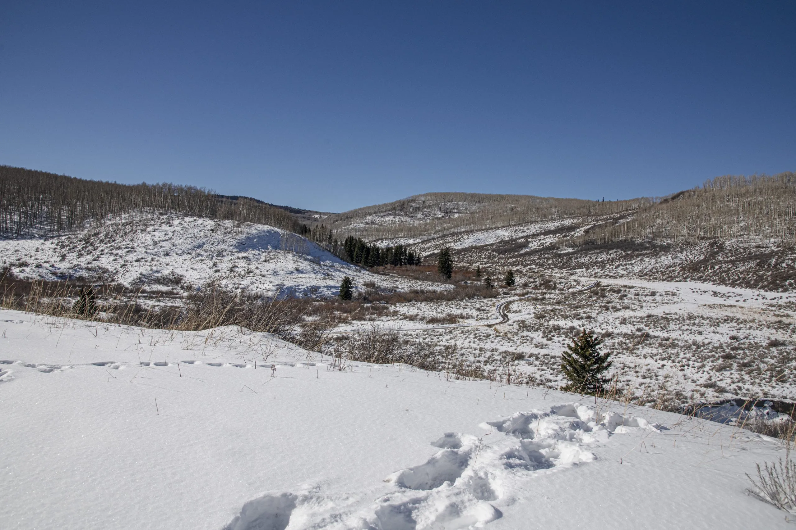
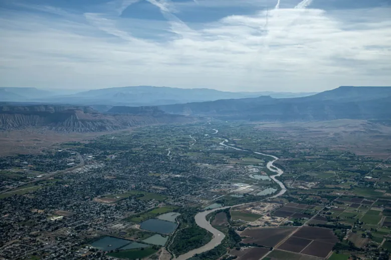
Nearly two hours east of Grand Junction on a remote dirt road on the Grand Mesa is a nondescript, shallow, sage-brush-covered valley where two creeks meet.
The site, at 8,200 feet in elevation, is home to a wooden corral where ranchers with grazing permits gather their livestock and to the Owens Creek Trailhead where hikers set out for nearby Porter Mountain.
It’s also the spot where the largest domestic water provider on Colorado’s Western Slope plans to someday build a reservoir. The proposed Owens Creek Reservoir is modest in size, at about 7,000 acre-feet. It would help Ute Water Conservancy District satisfy the needs of its 90,000 customers into the future.
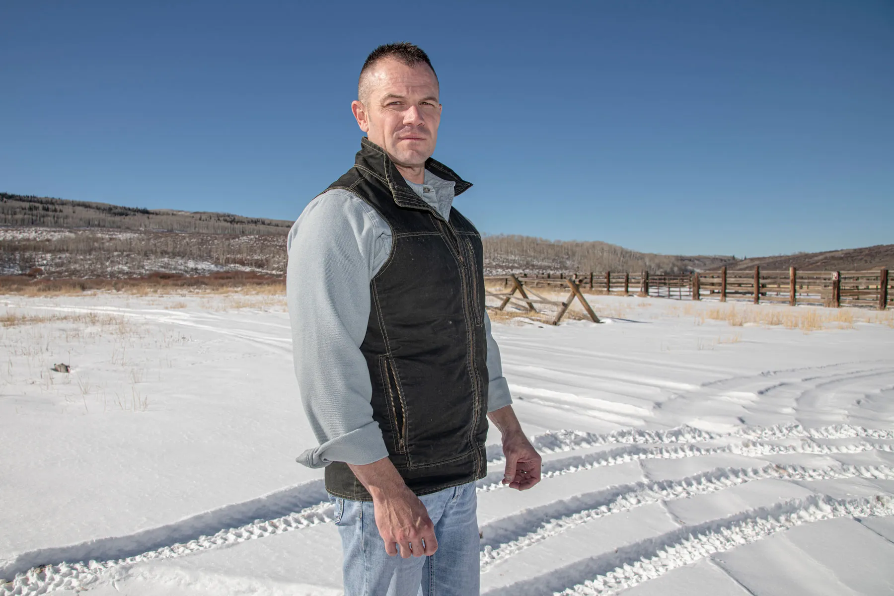
“Our job as a water provider is never done,” said Greg Williams, assistant manager at Ute Water. “You can develop one and you move onto your next project and go through that same process.”
Ute Water Assistant Manager Greg Williams, left, stands at the site of the proposed Owens Creek Reservoir on the Grand Mesa. Cities across the state have conditional water rights that save their place in line while they work to develop projects. Photo credit: William Woody
In most cases, water in Colorado must be put to beneficial use to keep a right to use it on the books. The cornerstone of Colorado water law is the system of prior appropriation, where the oldest water rights get first use of rivers. And hoarding water rights without using them amounts to speculation, which is illegal. But a Colorado water law feature known as a conditional water right allows water-rights holders to skirt this requirement and hold their place in line. The conditional water rights for the proposed Owens Reservoir date to 1972, although work to build this particular reservoir appears limited to preliminary studies and work on other related components of Ute Water’s system.
Ute Water, along with many other cities, conservancy districts and oil and gas companies across the Western Slope, are hanging on to water rights that are in some cases a half-century old without using them. Conditional water rights allow a would-be water user to reserve their priority date based on when they applied for the right, while they work toward eventually using the water. The result is millions of acre-feet worth of conditional water rights on paper that have been languishing for decades without being developed. Some of these rights are tied to large reservoir projects.
An analysis by Aspen Journalism found that across Colorado’s Western Slope, cities, conservancy districts, fossil fuel companies and private entities hold conditional water rights that would store about 2.6 million additional acre-feet from the Colorado River and its tributaries in not-yet-built reservoirs each bigger than 5,000 acre-feet. This is a staggering amount of water storage and more than the entire state of Colorado currently uses from the Colorado River basin, which is about 2.1 million acre-feet a year.
Most of this water would be stored in not-yet-built reservoirs, each bigger than 5,000 acre-feet. In some cases, the water would be stored in already-existing reservoirs, using conditional rights that would allow the reservoir to be refilled or enlarged.
Ute Water has plenty of company among the state’s conditional water rights holders. The Glenwood Springs-based Colorado River Water Conservancy District has rights from 1972 for the 66,000-acre-foot Wolcott Reservoir on Ute Creek in Eagle County; Mountain Coal Company says it wants to build the 75,000-acre-foot Snowshoe Reservoir on Anthracite Creek near Kebler Pass with rights from 1969; and Denver Water has plans for the 350,000-acre-foot Eagle-Colorado Reservoir on Alkali Creek in Eagle County using water rights from 2007. These are just a few examples of the 94 conditional water rights for new and existing reservoirs of 5,000 acre-feet or more planned for western Colorado identified by Aspen Journalism.
In a way, this planned water development represents the hopes and dreams for the future growth of the Colorado River’s Upper Basin states — Colorado, Wyoming, Utah and New Mexico. The 1922 Colorado River Compact promised 7.5 million acre-feet to the Upper Basin, which so far has never come close to using its half. The state of Colorado has the right to use 51.75% of the Upper Basin’s allocation.
But some experts say these proposed reservoirs are unrealistic wishes of the past, a vestige of the mid-20thcentury frenzy of dam building across the West that is mismatched for 21st century conditions. They say if this scale of future development comes to pass, it would upend the system of water rights, as well as harm the environment. They say the water court system that keeps these phantom reservoirs alive is being abused and should be reformed. In the era of historic drought, climate change and crashing reservoir levels, where users already see shortages in dry years, some say this amount of water for new development simply does not exist.
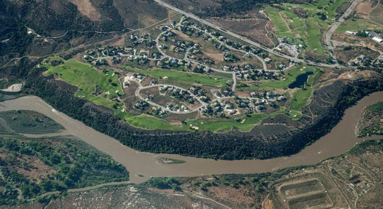
The Colorado River flows past a golf course near Parachute. Cities, conservancy districts, energy companies and private entities have conditional water rights for 2.6 million acre-feet of water to be stored across the Western Slope. Photo credit: William Woody
The Upper Basin’s dreams of water development also highlight a central tension at the heart of the current disagreement between the Upper Basin and the Lower Basin states of California, Arizona and Nevada. The two sides have not been able to reach an agreement about how the river’s two largest storage buckets, Lake Powell and Lake Mead, should be operated in the future and how cuts should be shared in drought years. Negotiations are currently at an impasse.
Over the past 100 years, the Lower Basin has fully developed its share of the river and then some. The Upper Basin has not, but it believes it is still entitled to, despite the contradictory nature of both committing to conservation while holding on to plans for new future uses.
“It’s especially a problem when we’re trying to find more water to reduce the amount of depletion on the Colorado River,” said Mark Squillace, a natural resources law professor at the University of Colorado Boulder. “If all these water rights were developed, it would be a disaster. I think everybody understands that.”
Holding on to conditional rights
The Colorado River meanders through the Grand Valley, where it turns peach orchards and alfalfa fields green. Ute Water, the largest domestic water provider on the Western Slope, plans to build additional reservoirs to serve its Grand Valley customers.
Photo credit: William Woody
Entities can’t just hang on to conditional water rights in perpetuity. To maintain a conditional right, an applicant must every six years file what’s known as a diligence application with the state’s water court, proving that they still have a need for the water, that they have taken substantial steps toward putting the water to use and that they “can and will” eventually use the water. They must essentially prove they are not speculating and hoarding water rights they won’t soon use.
A cottage industry has sprung up around these diligence filings. Engineering firms produce studies that show a conditional water rights holder has worked to develop the water right. Attorneys file diligence applications with the water court and then see them through the sometimes yearslong process to get it renewed for another six years.
Aspen Journalism’s analysis looked at only the biggest proposed reservoirs on the Western Slope, but every year, hundreds of diligence applications are filed statewide for smaller amounts of water.
And the bar for proving diligence is low.
“It’s only limited by the imagination of the lawyer who’s filing the application about what you can claim for diligence,” said Aaron Clay, a longtime water attorney and water court referee in the Gunnison River basin, who teaches community courses about the basics of water law across the Western Slope.
The standard for reasonable diligence is much lower now than it was decades ago, Clay said, because state officials want at least some of these reservoirs to be built. The thinking is practical and political: Building more reservoirs makes it easier to control the timing and amount of water Colorado lets flow downstream.
Water court judges are hesitant to abandon these conditional water rights, even if they have been languishing without being used for decades partly because in Colorado water is treated as a fully vested property right, where the state may have to compensate water rights holders if they take it away from them. And owners of these rights believe they are valuable and are reluctant to let them go. The status quo is maintained because there’s no incentive for anyone to scrub these unused water rights from the books. [ed. emphasis mine]
Some entities, such as Ute Water, have conditional water rights for several reservoirs, pipelines, pumping stations and other components of an integrated system. Applicants are not usually required to file separate diligence applications for each of the system’s components. For example, in Ute Water’s most recent diligence filing for Owens Reservoir, the conservancy district filed a combined application for 14 different components of an integrated system. The application, filed in August and still pending in Division 5 of water court, claims that work on one feature of the system constitutes reasonable diligence on all the features of the system.
Municipal water providers such as Ute Water are given special deference under Colorado water law through something called the Great and Growing Cities Doctrine. [ed. emphasis mine]
Ute Water Assistant Manager Greg Williams shows a map where the domestic water provider plans to build Buzzard Creek Reservoir and Owens Creek Reservoir. Cities, conservancy districts, energy companies and private citizens have 94 conditional water rights for use in new and existing reservoirs on the Western Slope.
Photo credit: William Woody
“The standard for diligence for a municipality is even lower,” Clay said. “We’re going to give them a little leniency with diligence by saying if you can still show us you’re going to need that water 30, 40, 50 years from now and you’re doing something toward it — studying it, working on the environmental issues or whatever — that’s going to be enough diligence to get you by for another six years.”
Owens Reservoir is just one of several Ute Water plans to develop. Williams said they are currently working to enlarge Monument Reservoir No. 1 and will then explore building Buzzard Creek Reservoir, Willow Creek Reservoir and Big Park Reservoir, all on the Grand Mesa.
“It remains to be seen the timing of when those reservoirs would be developed,” Williams said. “But our intent would be to continue developing each one of those sources.”
Squillace said that although he understands cities may need more leeway when it comes to long-term water planning, there is a lot of abuse of the conditional water rights system. The state water courts should be tougher on denying claims of diligence and stop granting extensions to water rights that haven’t been developed despite having had decades to do so, he said.
“You’re not supposed to sit on them for 20, 30, 40 years before you develop them,” he said. “It’s the failure of the state water courts to take diligence requirements seriously. They just apparently seem to give out these extensions of water rights without a whole lot of showing that there’s actually any kind of diligent work toward developing the water. I think it’s a huge problem.”
Uncertainty hangs over decades-old proposed reservoirs
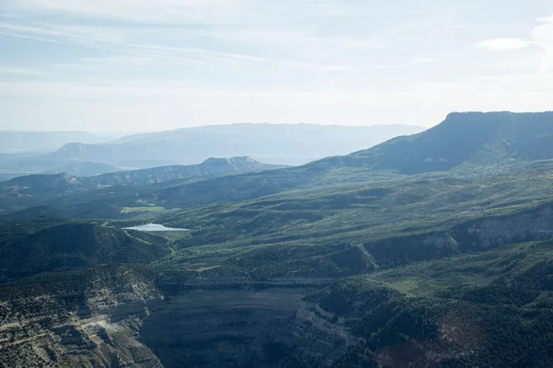
Smaller proposed reservoir sites are scattered across Grand Mesa in western Colorado, and are underpinned by decades-old conditional water rights.
Photo credit: William Woody
One way in which these conditional water rights could present a problem is the uncertainty they create for the state’s other water users, especially those who have put their water to use in the past 60 or so years.
Andrew Teegarden is a fellow at the Getches-Wilkinson Center for Natural Resources, Energy and the Environment at the University of Colorado School of Law. The University of Denver Water Law Review plans next fall to publish his paper “Uncertain Future: How Conditional Water Rights Have Created Unintended Consequences in Colorado.” When the owners of conditional water rights with older priority dates finally begin diverting water that they have not used for decades, they may cut off junior water users who began using water between the conditional right’s older date and the present day. Teegarden calls this “line-jumping,” and if all these proposed reservoirs were developed, it could upend the entire priority system. [ed. emphasis mine]
The solution, he said, is for Colorado to stop treating conditional rights as property rights. Lawmakers could also reform diligence standards and impose a strict time limit, such as 50 years, for applicants to put their water to beneficial use. Otherwise, these conditional rights should be abandoned.
“Clearly, the history and precedent surrounding conditional rights were well-intentioned on giving users within the system flexibility to implement large-scale projects and the security to hold their place in priority,” the paper reads. “These rights, though, come with unintended consequences and it is vital that reforms be implemented before people begin seeing their water rights curtailed or diminished.”
If these proposed dams are built, they could also have a negative impact on the environment. Western Resource Advocates and several other nonprofit and government organizations within Colorado work to improve riparian habitats and keep water flowing in rivers for the benefit of fish and ecosystems. Many of the groups’ projects try to mitigate the effects of cities and agriculture taking too much water out of rivers.
John Cyran, senior attorney with WRA’s Healthy Rivers Program, said this 2.6 million acre-feet of proposed reservoirs is a time bomb.
“Given that so many streams are already in stressed positions, it’s a big problem for the environment,” Cyran said. “We’re trying to look at the river as it is now and figure out how we can make it healthier. If a bunch of new claims come on the river, that work will be for nothing.”
Cyran brings up another potential issue with conditional water rights: They are able to be bought, sold, changed and transferred to another owner, another location or another type of use. In October, the Middle Park Water Conservancy District transferred conditional rights for a 20,000 acre-foot reservoir on Troublesome Creek near Kremmling to a private ranch for just $10. Some worry that this Western Slope water could be sold to the Front Range. And WRA is opposing another instance in the White River basin where an oil and gas company wants to transfer its storage rights to a new location.
“The idea is supposed to be a conditional right saves your place in line,” Cyran said. “There should be restrictions on water users trying to change those rights to some new purpose while retaining their senior priority. If you can’t use it for what you intended, it goes back to the river. You don’t get to use it for something else, and you don’t get to sell it to somebody to use for something else.”
Future water development tensions persist on Colorado River
But perhaps the biggest issue with 2.6 million acre-feet worth of new water storage may be the effect on, and implications for, the Colorado River basin as a whole. Water managers from each of the seven basin states are in the midst of hammering out a deal that would decide how Lake Powell and Lake Mead are operated and how cuts are shared among the seven states beyond 2026.
The Colorado River flows along I-70 in De Beque Canyon just east of the Grand Valley. Water users hold rights to store an additional 2.6 million acre-feet from the Colorado River and its tributaries in proposed reservoirs on the Western Slope.
Photo credit: William Woody
Colorado officials have been rolling out new talking points, which include that the Upper Basin already uses about 30% less water in dry years because the water simply isn’t there, so the Lower Basin should take a corresponding proportionate cut of 30%.
At a time when water managers are debating how to share cuts in a hotter, drier future and where some water users are already suffering shortages, why is this large scope of water development in western Colorado still planned?
JB Hamby, chair of the Colorado River Board of California and the state’s lead negotiator in Colorado River talks, who also serves on the board of the Imperial Irrigation District, which is the biggest water user on the Colorado River, laughed when Aspen Journalism told him that Colorado has plans to develop 2.6 million acre-feet worth of new reservoirs on the Western Slope.
“That’s crazy,” he said.
Hamby said building 20th century-style infrastructure to develop more water in the Upper Basin does not make sense. He said all water users in the basin should be working together to find ways to collectively reduce their use. That includes navigating differing interpretations of the Colorado River Compact without involving the U.S. Supreme Court.
“That’s our best step forward, not pretending like it’s 1965, which it is not,” Hamby said.
Hamby was getting at something that is a major sticking point between the Upper and Lower basins: two different interpretations of an aspect of the 1922 Colorado River Compact.
The agreement assumed there was 16 million acre-feet of available water each year, with 7.5 million acre-feet each allocated to the Upper and Lower basins. The goal was to reserve an equal portion of the river’s flows for the Upper Basin to prevent rapidly growing California from taking all the water. Giving half to the Upper Basin ensured that the states could slowly grow into their full allocation.
A century later, the Upper Basin still has not done that and currently uses about 4.3 million acre-feet a year. Experts have pointed out that 16 million acre-feet was an overestimate of how much water was available to begin with, and after two decades of being wracked by drought and climate change, that amount of water surely no longer exists in the Colorado River basin system. The foundation of the Colorado River Compact was flawed.
Upper Basin water managers cling not only to what was promised to them 100 years ago but to the belief that as long as they don’t use more than the 7.5 million acre-feet allocated to them, they will not be in violation of the compact. However, some Lower Basin advocates believe that regardless of the Upper Basin’s use, the upstream states could be subject to a compact call if they don’t deliver 7.5 million acre-feet a year. Because river flows have diminished over the past 20-plus years, additional use in the Upper Basin could exacerbate shortages and trigger litigation from the Lower Basin in the form of a compact call, which could force cuts on the Upper Basin. Legal uncertainties about how a compact call could unfold complicates the dynamic and heightens animosity between the two basins.
Amy Ostdiek, chief of the interstate, federal and water information section of the Colorado Water Conservation Board, said an additional 2.6 million acre-feet of reservoir storage won’t increase the risk of a compact call.
“We have the right to the beneficial use of 7.5 million acre-feet a year and in the Upper Basin, Colorado gets 51.75% of the available supply,” she said. “I do not see these projects as putting us in danger of going over that number.”
According to Jason Ullmann, Colorado’s head engineer at the Department of Water Resources, 2.6 million additional acre-feet of water exists in some years and could be developed, especially since most of that would be captured as spring runoff. The way reservoirs typically work is by storing snowmelt in the spring and releasing it as needed later in the year. But any new reservoir would be at the mercy of the particular and variable hydrologic conditions of any given year and may not always fill.
“Typically, storage buckets, the larger ones in particular, they may not accomplish a full fill every year,” Ullmann said. “It may not be a [2.6 million acre-foot] draw on the river every year. It’s just a water right for that amount of storage.”
Hamby said the Upper Basin point of view is one of the past and out of alignment with the hydrology of the river, which has been declining over the past two decades and is expected to continue to decline.
“The idea of developing new infrastructure to put more water to use does not make sense in this century,” he said. “And while there may be feelings of promises from 1922, this is 2024.”
What if it was all a dream?
One reason these proposed reservoirs don’t seem to worry many water managers is because nobody believes they will ever all be built. Although these projects represent the desires of the Upper Basin, this scale of development may be just a pipe dream.
Eric Kuhn, a Colorado River expert, author and former general manager of the Colorado River District, doubts that many of these reservoirs will be built, but not because the water isn’t there or because of the permitting hurdles, environmental impacts or expense of construction. Rather, Kuhn says there’s no longer a need for many of these storage buckets.
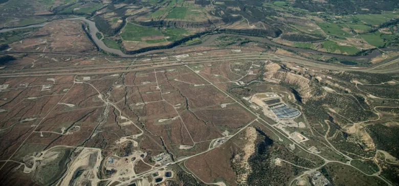
Oil and gas wells line the Colorado River along a rural stretch of western Colorado. Energy companies hold conditional water rights across the region, many linked to the potential future development of oil shale.
Photo credit: William Woody
Some of these conditional rights, especially in the Yampa-White-Green River basin, are associated with oil shale development, which has become less economically feasible in recent years. There are no new large-scale federally subsidized irrigation projects on the horizon. And as more agricultural land is converted to residential developments across the West, water use goes down.
Cities such as Aurora and Las Vegas have implemented aggressive conservation programs and have proved they can grow without using a lot more water. As the Upper Basin continues to urbanize, it may never grow into its 7.5 million-acre-foot allocation. The only reservoirs that will realistically be built, Kuhn said, will be small (1,000 acre-feet or less) and on a creek where there’s municipal demand.
“Maybe you need additional storage for streams that don’t have enough storage today, but that’s a tiny, minute amount,” he said. “Conditional water rights are a product of 50, 60, 70, 80 years ago, when they had a purpose. I don’t even see that they have a purpose anymore. They also represent a whole bunch of projects that, if they had been economically feasible, would have been built a long time ago.”
Although many entities continue to hang on to conditional water rights that they are unlikely to develop, some are starting to take a more clear-eyed approach, recognizing that some of these phantom reservoirs are dreams of the past and letting them go.
The River District has abandoned conditional reservoir rights on the Crystal River and other places; in January, a company with ties to oil shale development abandoned rights for a reservoir on Thompson Creek south of Carbondale; Colorado Springs recently gave up water rights for reservoirs in Summit County; and in October, the town of Breckenridge let go of water rights for two reservoirs on the Swan River but kept rights for a third: Swan River Reservoir No. 4.
James Phelps, director of public works for the town of Breckenridge, said they didn’t file the diligence claims this time for Swan River Reservoirs Nos. 1 and 2, which had water rights dating to 1981, because the town doesn’t need to develop that much reservoir capacity. Other factors in the town’s decision to not keep the reservoirs alive were the huge financial costs; the fact that housing developments encroached on the reservoir sites; and disturbance to the ecosystem in a place where residents place a high value on the environment.
“It was determined that if there was a need for the water in the future, whatever that need may be, we wouldn’t need to develop all three of those,” Phelps said. “We know that developing reservoirs is not an easy thing to do.”
Despite Colorado water courts’ tendency to rubber-stamp most diligence applications to keep alive decades-old unused water rights, there is at least one recent example of legal pushback on a reservoir enlargement project.
In October, a federal judge ruled that Denver Water’s Gross Reservoir expansion violated the Clean Water Act because it didn’t take into consideration the potential for a Colorado River Compact call and the declining hydrology of the basin. Although it’s unclear if this ruling would set a precedent for any other dam and reservoir project in Colorado, it signals a growing understanding of the risks that new water development could pose to the entire Colorado River system.
“The Colorado River Compact rests on a politically unpalatable truth — the Compact promised the basin states water that simply does not exist,” a footnote in the ruling reads. “The Court emphasizes this context for good reason: The cracked foundation of the Colorado River’s management system all but demands skepticism over any proposal that will affect the hydrology of the Colorado River basin.”
This story was produced by Aspen Journalism, in partnership with The Water Desk at the University of Colorado Center for Environmental Journalism.
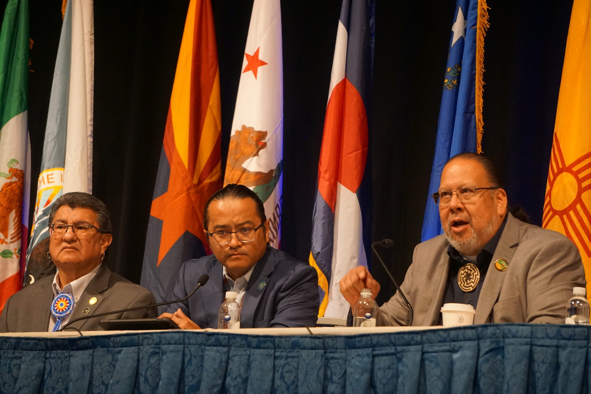
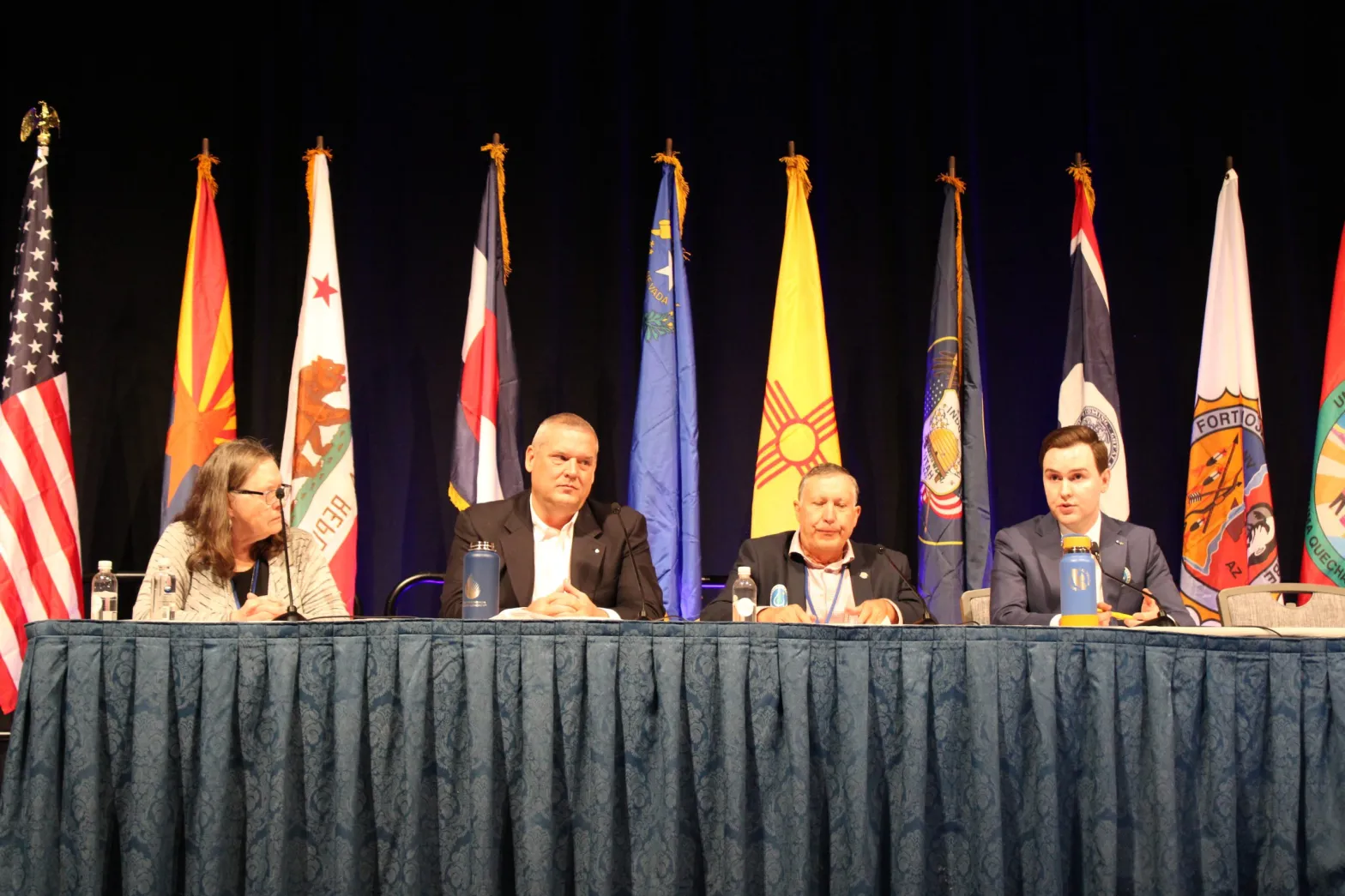
Ute Mountain Ute Chairman Manuel Heart, Navajo Nation President Buu Nygren, and Gov. Stephen Roe Lewis of the Gila River Indian Community during a “Soverign-to-Soverign Nation” panel at the Colorado River Water Users Association conference. (Photo: Jeniffer Solis/Nevada Current)
Since 2021, a handful of Colorado River Basin tribes have significantly boosted water supply in Lake Mead through voluntary contributions, helping stabilize a crucial reservoir that 25 million people rely on.
The consequences of a two-decade drought in the west and a shrinking river have given tribes leverage in negotiations over how the river’s water is managed, and persuaded the federal government to pay tribes to conserve water while funding millions in additional infrastructure.
More conservation arrangements with tribes were reached last week, after tribes met with the Bureau of Reclamation during the annual Colorado River Water Users Association conference to extend water-saving agreements that will conserve another 43,000 acre feet of water in Lake Mead, or enough water to serve about 14,000 households for a year.
The San Carlos Apache Tribe in southeastern Arizona agreed to leave 30,000 acre feet in Lake Mead in exchange for $12 million from the federal government. The Fort Yuma Quechan Indian Tribe along the Arizona-California border also signed an agreement to conserve 13,000 acre feet of Lake Mead water for $5.2 million.
Those investments build on other historic water-saving agreements with Colorado River Basin tribes in recent years designed to boost water levels in Lake Mead.
Last year, the Gila River Indian Community in Arizona received $50 million from the Inflation Reduction Act in exchange for agreeing to leave 125,000 acre feet of water in Lake Mead, adding about two feet of water to the reservoir. The Gila River Indian Community committed to similar water savings this year and in 2025 for an additional $100 million in funding, conserving enough water to supply half a million homes.
In September, the Gila River Indian Community also received $107 million from the Inflation Reduction Act for three separate water conservation infrastructure projects, after agreeing to leave an additional 73,000 acre-feet of water in Lake Mead over the next decade.
During the annual Colorado River Water Users Association conference last week, the Bureau of Reclamation also announced an agreement with the Colorado River Indian Tribes to fund a $5 million study on constructing a new reservoir that could save up to 35,000 acre feet for the tribe, and help them develop their water rights.
Additionally, the Bureau of Reclamation announced $21.5 million in funding from the Inflation Reduction Act last week to help the White Mountain Apache Tribe in Arizona plan and design a rural water delivery system.
The Biden administration committed more than $6 billion to support water infrastructure in Tribal communities between the Bipartisan Infrastructure Law and Inflation Reduction Act, but any future funding will likely depend on what President-elect Donald Trump chooses to do with unspent funds.
During the campaign Trump said he would claw back unspent IRA funding.
Looking to the lame duck
Tribal communities also hope Congress passes and the president signs into law substantial federal water project legislation before the new Congress is sworn in and Trump is inaugurated.
The $5 billion Northeastern Arizona Indian Water Rights Settlement Act that would secure water rights for the Navajo Nation, Hopi Tribe and San Juan Southern Paiute Tribe.
The federal legislation authorizes $5 billion to acquire, build, and maintain essential water development and delivery projects, including a $1.75 billion distribution pipeline. The three tribes would also be guaranteed access to over 56,000 acre-feet of Colorado River water and specific groundwater rights protections.
Navajo Nation President Buu Nygren emphasized the urgency of the Northeastern Arizona Indian Water Rights Settlement. Nygren said he hopes basin states will support and advocate for the settlement, which could boost its chances of passing before a new administration takes the White House next month.
However, some Colorado River Basin states have expressed concerns about the settlement and its impact on water use and future management, a fact Nygren acknowledged.
“I was hoping to come in today that we have some consensus, but there’s one underlying issue that we’re trying to resolve,” Nygren said.
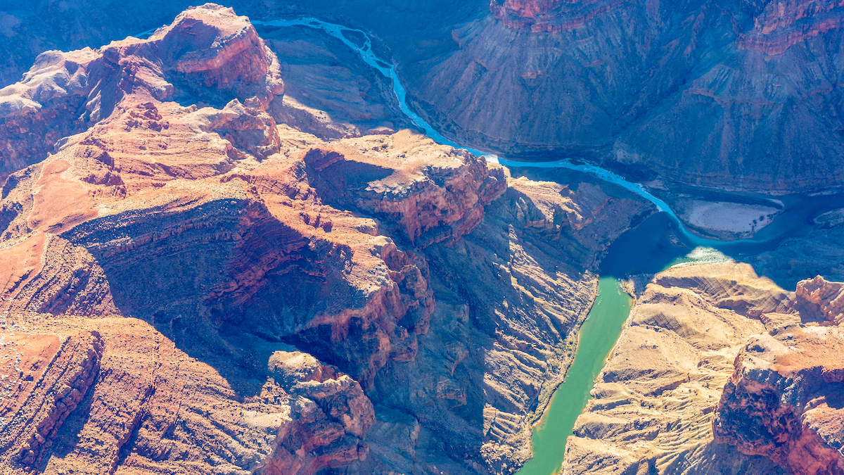
Confluence of the Little Colorado River and Colorado River; Credit: EcoFlight
During a press event last week, New Mexico’s representative on Colorado River matters, Estevan Lopez, said the Upper Basin states are concerned the settlement would allow tribes to lease water from the Upper Basin to the Lower Basin.
“When you move water across the basin boundary, that has always required a seven state consensus,” Lopez said.
“We feel it’s imperative that we need to have an actual consensus among the states if that’s going to move forward,” Lopez said.
Lower Basin states — Nevada, Arizona, and California — and Upper Basin states — Colorado, New Mexico, Utah, and Wyoming — have been at odds for months over how to manage the river after current management rules expire in 2026.
Tribal leaders noted that water settlement bills have historically been passed during lame duck congressional sessions, meaning that if it does not pass now, the legislation will have to effectively restart the process anew in the next Congress.
Nygren said he is still hopeful Congress can pass the water settlement bill during the lame duck session, as either a stand-alone bill or as part of a larger package, and urged the seven basin states to support the settlement.
“We’ve got a Congress that’s willing, that’s excited. All we gotta do is come to consensus, and then we put it in Congress’s hands. It would be a great celebration to see President Biden sign off on that within the next couple of weeks,” Nygren said.
Gov. Stephen Roe Lewis of the Gila River Indian Community echoed Nygren’s optimism.
“I remain ever hopeful that we will be celebrating the first anniversary of the Northern Arizona settlement next year,” he said
Lewis added he is not pessimistic about the Trump administration if the settlement fails to come together before Biden steps down, noting that the Drought Contingency Plan in 2019, which stabilized the Colorado River through voluntary reductions and increased conservation, was authorized when Trump was president in 2019.
“I remain hopeful that [the Trump administration] will help us finish this journey that we’re on for those new guidelines. I’m also not worried about Congress stepping up and providing the new authority and funding that we may need to implement the kinds of ideas that we see are necessary,” Lewis said.
Click the link to read the article on the ENSO Blog (Emily Becker):
December 12, 2024
There’s a 59% chance that weak La Niña conditions will develop shortly. This is very similar to last month’s estimate, just applied to November–January. It’s true; if you read last month’s post, you can pretty much carry that information over to this month. However, we have lots of fun sciency details to talk about this month, so stick around!
The office holiday party
La Niña, the cool phase of the El Niño/Southern Oscillation (ENSO), is a coupled ocean-atmosphere pattern in the tropical Pacific Ocean. To qualify as La Niña conditions, we need to see (1) surface water in the tropical Pacific that is at least 0.5 °C (just shy of 1˚F) cooler than the long-term average (long-term=1991–2020) and (2) evidence of changes in the Walker circulation, the atmospheric circulation over the tropical Pacific. This evidence includes stronger upper-level and near-surface winds (the trade winds), more rain than average over Indonesia, and less rain over the central Pacific.
Cocktails with your old friends
Speaking of the tropical ocean and atmosphere—where are they now? Our key monitoring index, the temperature of the surface water in the Niño-3.4 region, is still running just a little cooler than the long-term average. According to our most reliable long-term dataset, ERSSTv5, the November index was -0.2 °C. While below average, this does not exceed the La Niña threshold of -0.5 °C.
It’s important to have both the ocean and the atmosphere showing changes, because there are feedbacks between them (this is the “coupled” part) that help La Niña grow and stick around for several months. When La Niña (or El Niño, can’t forget him) are present, they change global atmospheric circulation in known ways, allowing us a window into potential seasonal temperature and rain/snow patterns.
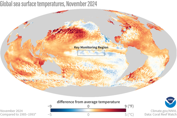
November 2024 sea surface temperature compared to the 1985-1993 average (details on climatology from Coral Reef Watch). The box indicates the location of the Niño-3.4 ENSO-monitoring region in the tropical Pacific. The surface of the east-central tropical Pacific is slightly below average temperature, but much of the global ocean remains warmer than average. NOAA Climate.gov image from Data Snapshots.
Global ocean temperatures have been running way above average for more than a year now, and as you can see from the map above, November was no exception. [emphasis mine]
Meanwhile, looking up, we see an atmosphere that is showing signs of a Niña-ish pattern. In November, the trade winds were stronger than average, upper-level winds were also stronger, and the tropical Pacific was much less rainy than average. I’ll have more details on this in a few paragraphs.
Dance club
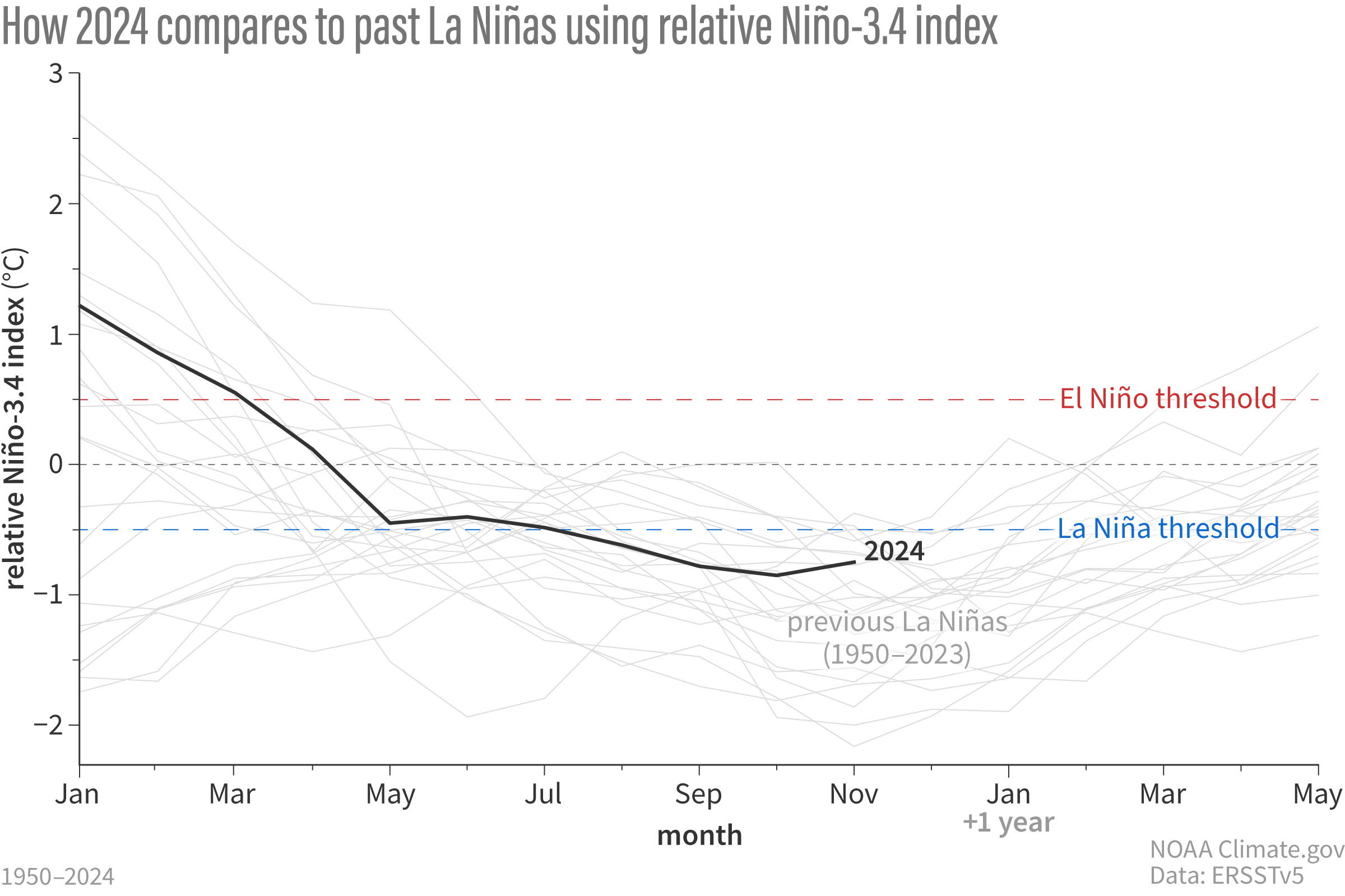
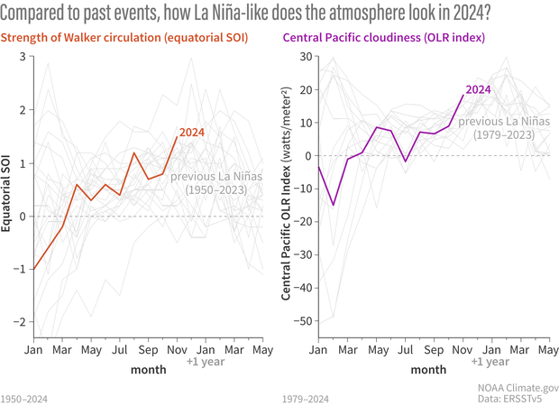
Let’s look at that Niño-3.4 sea surface temperature compared to all the La Niña events since 1950. As you can see below, the Niño-3.4 Index decreased sharply after the peak of last winter’s El Niño, but kind of stalled out in the spring and has been solidly in ENSO-neutral territory for months now.
How sea surface temperatures in the Niño-3.4 region of the tropical Pacific changed over the course of all La Niña events since 1950 (gray lines) and 2024 (black line). This shows the traditional calculation for Niño-3.4, the monthly temperature compared to the most recent 30-year average (1991–2020 for the 2024 line). By this measure, the La Niña threshold has not been crossed, and ENSO is still neutral. Climate.gov graph, based on data from Michelle L’Heureux from CPC using ERSSTv5.
However, that lit-up global ocean we see in the map above may be getting up in ENSO’s grill. Over the past few months, we’ve talked about the Relative Niño-3.4 Index, which compares the Niño-3.4 region to the rest of the tropical oceans. When you take the traditional Niño-3.4 and subtract the tropical average ocean surface temperature, you find a Relative Niño-3.4 Index that dips past the La Niña threshold (see footnote for additional details on Relative Niño-3.4 calculations). In short, the traditional Niño-3.4 says no La Niña yet; the relative index would say we’re already there.
How sea surface temperatures in the Niño-3.4 region of the tropical Pacific changed over the course of all La Niña events since 1950 (gray lines) and 2024 (black line), based on the relative Niño-3.4 calculation. Here, the monthly temperature is compared to the most recent 30-year average, but then the tropical average ocean surface temperature is subtracted, to account for global ocean warmth. By this measure, the La Niña threshold of 0.5 °C has been crossed. The relative Niño-3.4 index is not our official metric, though, and it needs more research. Climate.gov graph, based on data from Michelle L’Heureux.
With that in mind, Michelle investigated some measurements of the atmospheric component of La Niña. Specifically, she graphed the Equatorial Southern Oscillation and the amount of clouds in the central tropical Pacific. The Equatorial Southern Oscillation compares the surface pressure in the eastern equatorial Pacific to the western. When it’s positive, that means the western pressure is weaker than average and the eastern pressure is stronger than average, indicative of a stronger Walker circulation—La Niña’s signature.
Clouds are estimated with satellite observations of outgoing longwave radiation, or “OLR” for short. Very cold surfaces, like the top of a deep thunderstorm cloud, emit less OLR than a warmer surface, like a cloud-free ocean. Therefore, more OLR generally means fewer clouds. Fewer clouds in the central tropical Pacific is also a La Niña signature move.
We don’t use these monthly atmospheric indexes for declaring ENSO events, because they are much more variable (they jump, jump around) than the ocean index. You can see this in how zig-zaggy the lines are in the below graphs compared to the above. They are very useful for understanding how conditions are evolving, though.
Two ways of looking at the atmospheric conditions in the tropical Pacific: the Equatorial Southern Oscillation (left) and cloudiness in the central Pacific (right). The colored lines show 2024, while the gray lines are every La Niña on record. Both measurements provide evidence that the Walker circulation is stronger than average, a La Niña atmospheric signature. Climate.gov graph, based on data from Michelle L’Heureux.
When Michelle graphed these two atmospheric indexes, she found that they both looked pretty darn La Niña-y. (In these graphs, higher numbers are more like La Niña). In fact, the OLR from November 2024 ranks higher than any previous La Niña! However, these numbers do change a lot from month to month because of other subseasonal patterns like the Madden-Julian Oscillation (which was active), so it could bounce back down into the mosh pit next month.
Afterparty
So what do we take home from all this? The atmosphere looks like La Niña, and has for a while, but the ocean doesn’t, at least by our traditional sea surface temperature measures. Forecasters still think it’s likely that the traditional Niño-3.4 Index will cross the threshold soon, in part helped along by the strong trade winds, which cool the surface and keep warm water piled up in the far western Pacific.
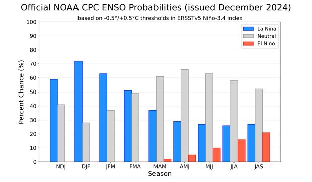
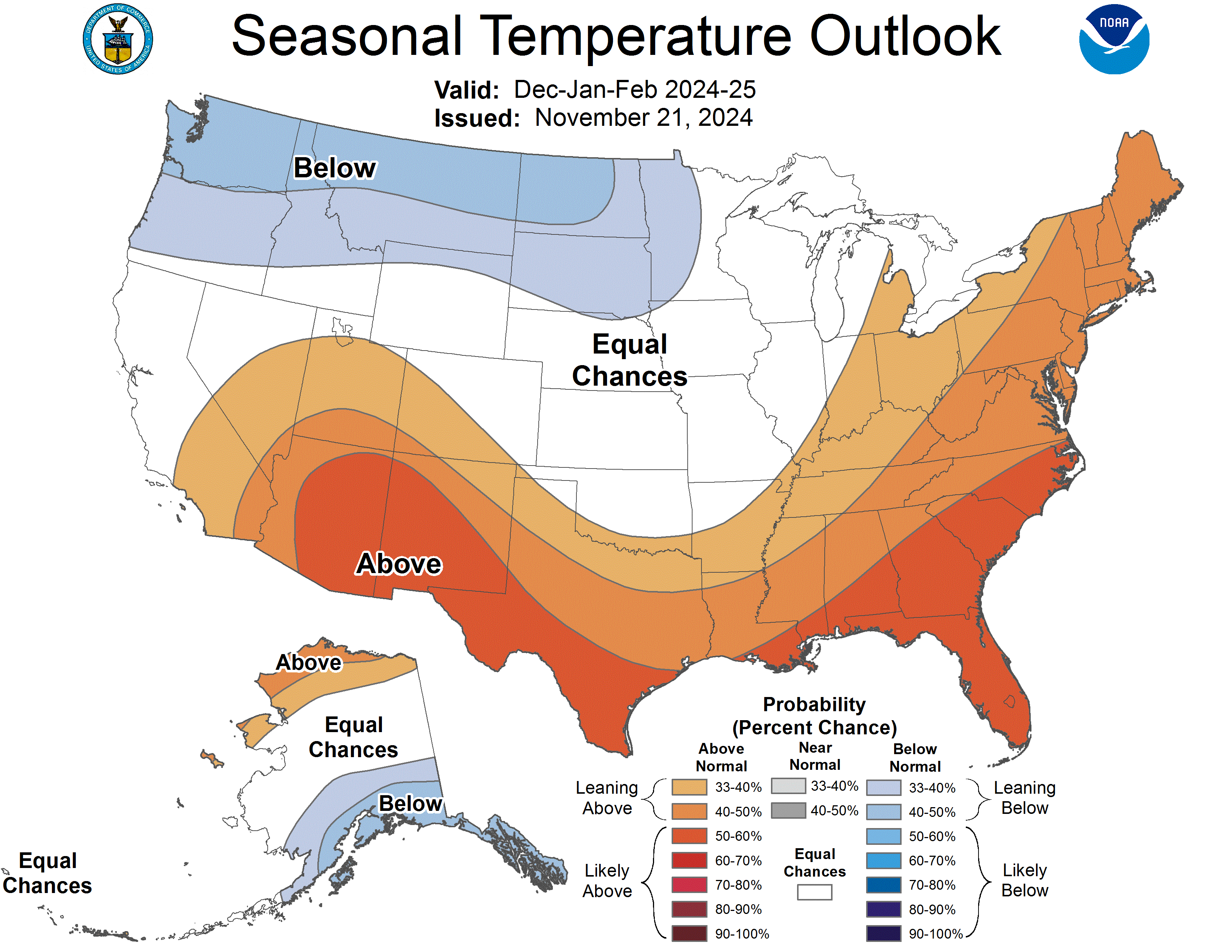
Out of the three climate possibilities—La Niña, El Niño, and neutral—forecasts say that La Niña conditions are the most likely for the November–January season (blue bar over the NDJ label, 59% chance). NOAA Climate Prediction Center image.
But even if we do declare a La Niña Advisory soon, it will very likely be a weak event at most. Check out Nat’s recent post for the implications of a weak La Niña on North American winter forecasts.
This is very much a developing story—you’re reading about scientific development and discovery in real time. Our official ENSO metrics may not describe ENSO quite as well in the context of the much-above-average global ocean temperatures we’ve seen over the past year, but we don’t know yet if the relative Niño-3.4 Index is going to consistently describe ENSO better into the future. We need more research to better understand what is happening.
What we do know is that the ENSO Blog is going to keep you up to date and make sure you’re never late to the party!
Footnote
After you subtract the tropical average (20°S–20°N) sea surface temperature anomalies, the difference has lower variance than the original SST anomalies. This is why the computation of relative Niño-3.4 also has a variance adjustment where you multiply by a scaling factor (ratio of the standard deviation of the SST anomaly with the standard deviation of the difference index). If you want to see how this really works, here is some github code to compute relative ONI using observations. In the relative SST map above, the standard deviation of SST anomaly at each grid box is used instead of the standard deviation of the Niño-3.4 index.
he Rio Grande cutthroat trout, icon of Southern Colorado and New Mexico, after years of fighting for survival with the help of countless human hours, will not find itself on the endangered species list. The U.S. Fish and Wildlife Service recently announced the trout is not in danger of extinction or likely to become so in the foreseeable future, after two and half decades of review and conservation work.
After completing a final review, the Service concluded that the Rio Grande Cutthroat trout’s current status in the mostly remote water ways of Colorado and New Mexico doesn’t meet the definition of a threatened or endangered species, and won’t be listed under the Endangered Species Act.
“CPW staff have worked tirelessly for decades to ensure Rio Grande cutthroat trout continue to persist,” said Matt Nicholl, Colorado Parks and Wildlife’s assistant director of aquatic wildlife. “The responsibility of successfully managing this species deeply aligns with our mission, and we are thankful for the continued support and collaboration with all of the partners who have made this announcement possible.”
Photo credit: Colorado Parks & Wildlife
Over the course of the past three decades, biologists from Colorado have added 94 populations of pure Rio Grande cutthroats to 239 miles of stream, through chemical reclamations and habitat and connectivity enhancements related to these species.
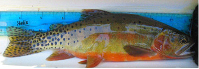
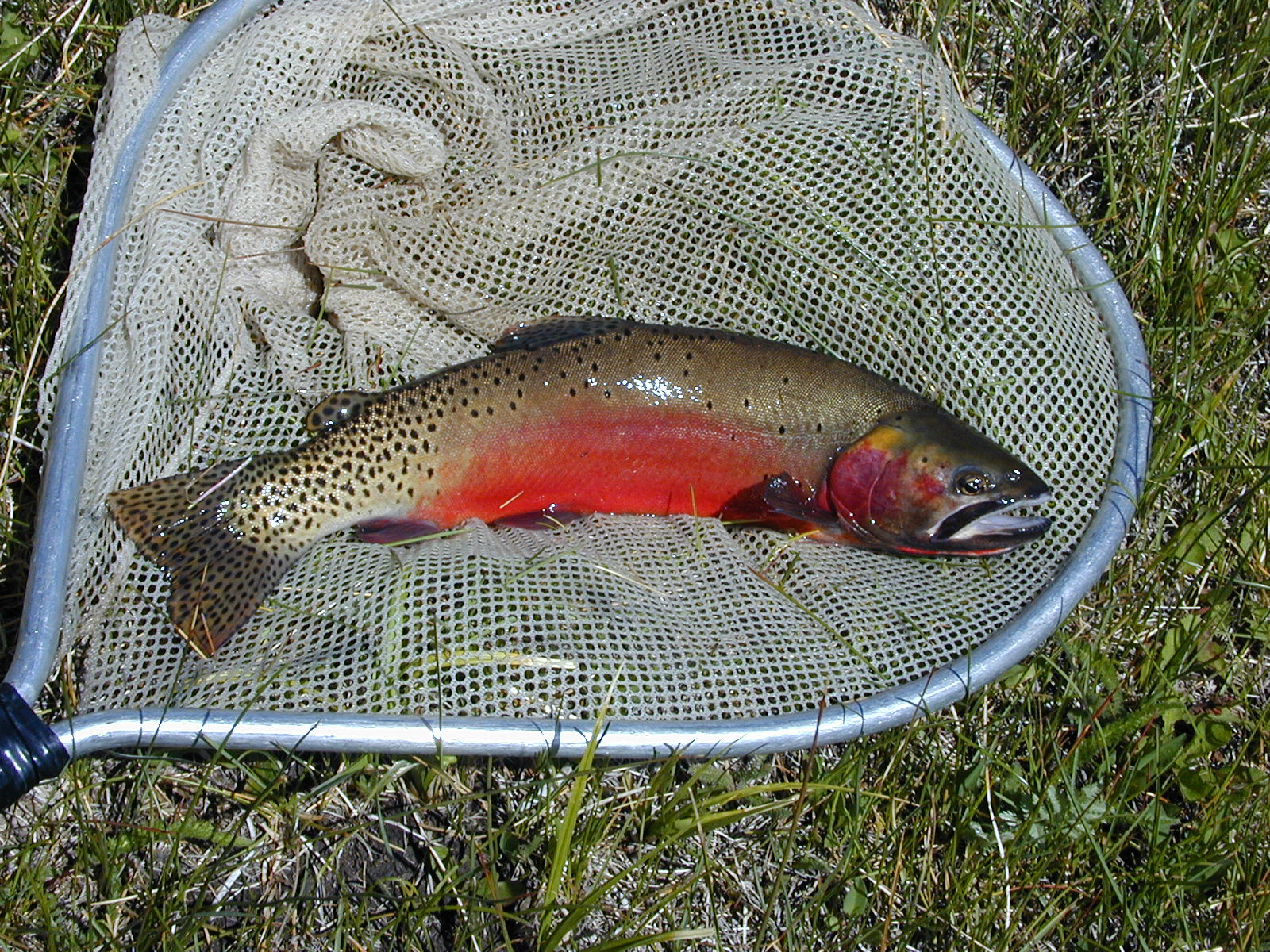
The Rio Grande cutthroat trout is one of 14 subspecies of cutthroat trout. It lives in mostly remote, mountainous streams in New Mexico and southern Colorado. The fish is a colorful red, orange and yellow, peppered with dark spots.
Cutthroat trout historic range via Western Trout
Rio Grande cutthroat trout can be found in high-elevation streams and lakes of the Rio Grande, Canadian and Pecos River drainages in Colorado and New Mexico, making it the southern-most cutthroat trout. Currently, the fish only occupies 12 percent of its historic habitat in about 800 miles of streams. Biologists estimate that 127 conservation populations now exist in the two states, and 57 of those populations are considered to be secure.
“The Rio Grande cutthroat trout has been New Mexico’s state fish since 1955,” said Amy Lueders, the Service’s southwest regional director. “This fish is extremely important for recreational angling in New Mexico and Colorado and management efforts have focused on population restoration, habitat improvement and research. We are thankful to the Rio Grande Cutthroat Trout Conservation Team because their continued work, along with efforts by other partners, will support the health of both the subspecies and its habitat into the future.”
To complete its life cycle, the cutthroat trout needs a network of slow and fast streams with clear, cold, and highly oxygenated water and highly biodiverse streambeds.
Since 2003, Colorado Parks and Wildlife and multiple partners, including federal agencies, states, tribes, municipalities, non-government organizations and private landowners, have worked to conserve the species and implement long-term management actions to ensure its persistence and survival.
A series of collaborative frameworks of this group was updated in 2013 and again in 2023 with a conservation agreement and conservation strategy that aimed for long-term conservation.
“This decision is in response to all of our hard work between all of our partners,” said CPW aquatic biologist Estevan Vigil. “The whole Rio Grande Cutthroat Conservation Team, this is a win for all of us and shows we’re working hard to conserve the species without making that federal protection necessary and that we are making gains for the species. The decision to not list the Rio Grande cutthroat doesn’t mean we can stop. It just means we are on the right track.”
The past, present and future threats to the Rio Grande cutthroat trout have been monitored and evaluated closely. The primary factor impacting the survival of the subspecies is the presence of nonnative species of trout, including rainbow trout, brook trout and brown trout. The conservation populations of Rio Grande cutthroat trout, or populations with less than 10 percent genetic introgression from nonnative trout, occupy approximately 12 percent of the species’ historical range. Additional threats include habitat loss, reduced habitat connectivity and whirling disease.
Those other fish will outcompete, prey upon and hybridize with Rio Grande cutthroats. As a result, pure populations of Rio Grande cutthroat trout are restricted primarily to headwater streams to avoid an overbearing mix of disease and genetics.
View the U.S. Fish and Wildlife Service’s findings here.
Credit: Colorado Parks & Wildlife
The trout has had a specialized team focusing on its survival throughout the restoration effort. The Rio Grande Cutthroat Trout Conservation Team is made up of state agencies in New Mexico and Colorado, as well as federal agencies, tribes, and non-government organizations.
In the past 10 years, the conservation team has conducted 13 population restorations by removing nonnative trout and reintroducing Rio Grande cutthroat trout.
The Rio Grande Cutthroat Trout Conservation Team meets in January each year to coordinate rangewide goals and objectives. Vigil said the team serves to provide checks and balances to each other to make sure holistic goals are met.
“Following that meeting, we all go back to the areas we manage and divide and conquer all summer to meet the goals set of conserving this species,” Vigil said. “Through this shared commitment to collaborate and take actions, the future for this native species is bright throughout the Rio Grande Basin.”
The conservation team has conducted 13 reclamation projects to restore the fish to its native streams in the past decade, and additional projects in Colorado will soon lead to further conservation populations.
Recognizing declines, CPW began conservation efforts for this species in the early 1980s. Work included genetic testing, invasive species removal, habitat protection and enhancement, and broodstock development.
In Colorado, Rio Grande cutthroats are spawned in the wild by CPW biologists and eggs are raised at the Monte Vista Hatchery. Since 2020, CPW has stocked 24 waters with Rio Grande cutthroats raised at the hatchery.
A new conservation population of Rio Grande cutthroat trout was designated in 2023 when a survey revealed multiple age classes of the species following a successful 2015 restoration project on the Roaring Fork drainage upstream of Goose Creek in the Weminuche Wilderness.
Recent reclamation projects also have been conducted on the North Fork and South Fork of Trinchera Creek, Sand Creek, and Rito Hondo Reservoir, but those populations won’t count as conservation populations until future surveys reveal multiple age classes of Rio Grande cutthroats.
“We are continuing to reclaim waters for native cutthroat trout by removing non-native fish and restocking with natives,” Vigil said. “We have a lot of projects and some in the process of being rebuilt. We know we are making good progress on the conservation of the species, and this is confirmation we are doing our jobs correctly and making progress.”
Over the past two years, species experts from CPW have served on the Technical Advisory Team to support USFWS in developing a Species Status Assessment. This included thorough input on early drafts of the assessment and enhancing scientific accuracy and defensibility of this document to support the final decision.
“CPW biologists played a significant role in the writing of this strategy, which details specific conservation actions and collaborative approaches that will reduce and/or eliminate threats to the long-term viability of the species,” said CPW senior aquatic biologist Jim White. “Following this announcement from the USFWS, we look forward to continued partnership with the conservation team as we continue to advance conservation goals for these unique species.”
Rio Grande cutthroat trout via Colorado Parks and Wildlife
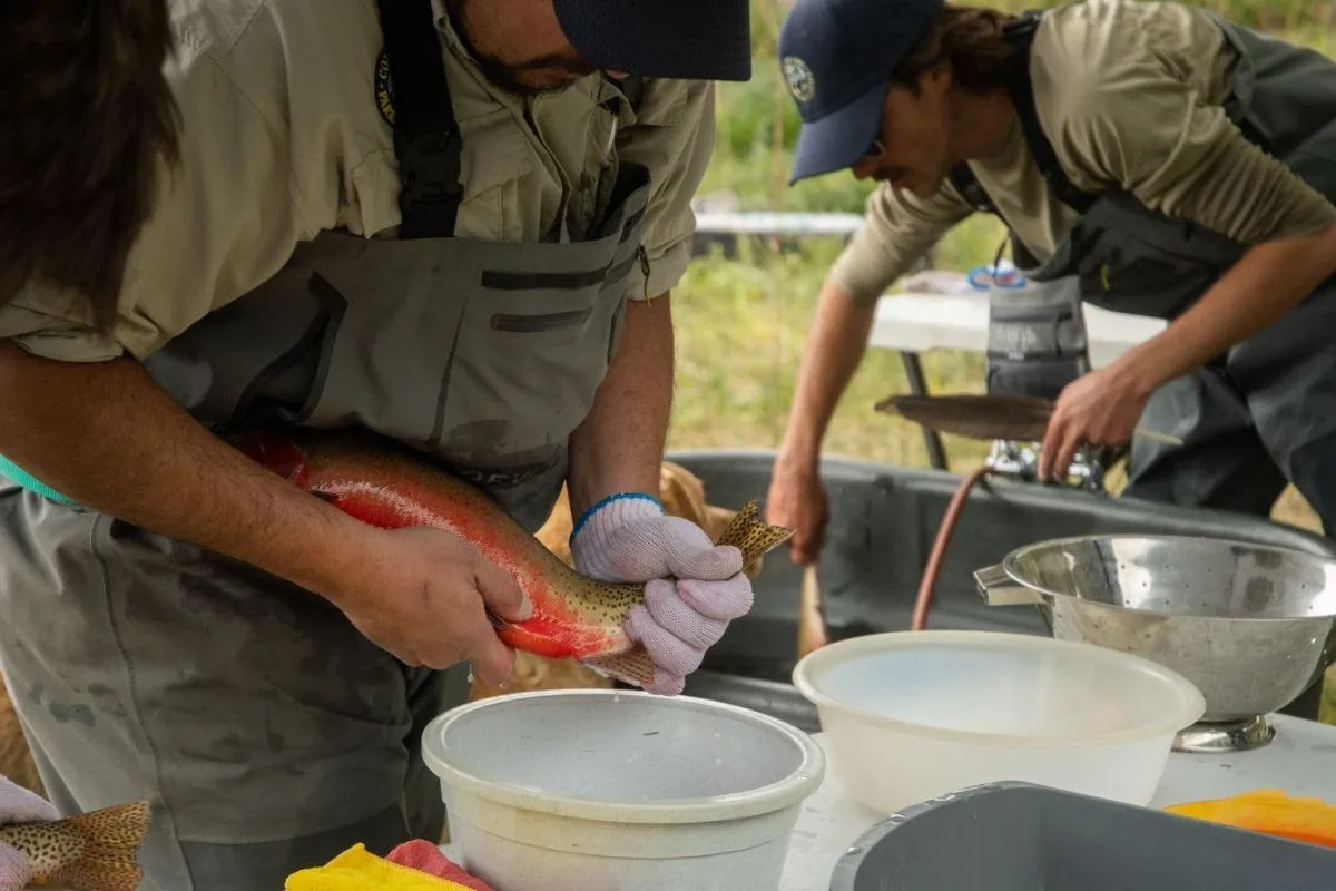
Kevin Terry, a project coordinator for Colorado Trout Unlimited, holds up a Rio Grande cutthroat trout at Upper Sand Creek Lake.Workers administer the plant-based chemical compound rotenone at Upper Sand Creek Lake in the Sangre de Cristo range. The chemical kills all fish in the waterway so that Rio Grande cutthroat trout, a native species, had be restored to the habitat. (Provided by Colorado Fish and Wildlife)The Rio Grande cutthroat trout has dwindled in its native habitat. A multi-agency effort to restore it still can inspire anger and concern. (Provided by Colorado Fish and Wildlife)A Rio Grande cutthroat trout is pictured in 2014. Photo courtesy of U.S. Fish & Wildlife ServicePhoto credit: Colorado Parks & Wildlife
Click the link to read the article on the NOAA website:
December 11, 2024
A patchwork of green circles dot the landscape across the High Plains of the United States, their green grid created by sprinklers irrigating with well water pumped from the Ogallala Aquifer. Relying heavily on the Ogallala Aquifer, farmers and livestock growers in this semi-arid region produce nearly one-fifth of the wheat, corn, cotton and cattle produced in the United States as of 2011.
The importance of the Ogallala Aquifer and the communities it supports cannot be overstated. Irrigation of crops significantly boosts productivity and supports the socioeconomic lifeblood of this region. Agricultural sales from the Ogallala Aquifer region contribute billions of dollars to local economies and national gross domestic product.
However, the Ogallala Aquifer is in trouble. Groundwater measurements in the Ogallala Aquifer show ongoing declines in aquifer water quality and quantity. The shared water resource can be managed sustainably, but this will require cooperation by water users within the region and support from those outside of the region who also benefit from it.
The Summit brought together more than 230 crop and livestock growers, scientists and technical experts, water managers, governments (local, state, and federal), and other partners to work to address water management challenges within the region. Summit opening remarks were delivered by Kansas Governor Laura Kelly and U.S. Senator for Kansas Jerry Moran.
“Without water there is no agriculture, and without agriculture there are no rural communities in the High Plains,” said Kansas Senator Jerry Moran. “The future of the High Plains region depends on leadership to preserve water.”
This third Summit built on successes of past Summits led in 2021 and 2018 by the Irrigation Innovation Consortium. Key takeaways from the Summit were summarized in the recently published 2024 Ogallala Aquifer Summit Summary Report. The Summit program was split among four sessions, each devoted to some aspect of the theme, “Building Trust, Mobilizing Collaboration.”
Session 1: Applying Science and Data for Regional Agricultural Sustainability
The opening session focused on the science of the hydrology and climatology of the region with the goal of building trust and collaboration between scientists, who are working to understand the dynamics of the Aquifer, and business leaders and decision-makers, who are implementing the knowledge being produced. Presenters highlighted the value seasonal climate predictions provide to manage risks to the community, as well as tools to support decisions to withdraw groundwater.
Session 2: Harnessing the Power of Peer Networks
The next session focused on harnessing the power of peer networks to bring people together to share successes and lessons learned. This included a presentation about the successes of the Master Irrigators program in some states, and successes in individual regions and farms when solutions are implemented.
Session 3: Mobilizing Supply Chain Partners
The second day opened with a focus on the nationwide and global risk presented by Ogallala water challenges. Water scarcity in this region impacts local, national, and global economies, and even national security, because, as one panelist pointed out, “food security is national security.” Producers underscored the need to recognize the economic value of water in approaches to address these risks.
Subsequent discussions focused on mobilizing supply chain partners to support agricultural sustainability within the region. Sustainable water use in the Ogallala not only impacts local farmers within the region, but major corporations from across the country and the world who rely on Ogallala water. Customers at grocery stores across the country buy bread or beef that was grown from Ogallala water. Northern Texas alone produces 20% of U.S. cotton using water that is drawn from the Ogallala Aquifer. This cotton is being worn as t-shirts or blue jeans by millions of people around the world. Corporations who rely heavily on production in the High Plains regions are invited to be part of the ongoing conversation about sustainable use, hence the importance of mobilizing supply chain partners.
Session 4: Building the Future We Want: Thinking and Acting Intergenerationally
The final session focused on building intergenerational collaboration. Thinking and acting intergenerationally is about making sure there is a future for the next generation in the region. Participants discussed their desire for flexible and voluntary tools to manage the aquifer and a need for more educational opportunities to create future leaders and a skilled workforce for the next generation’s water.
The conference ended with a capstone session that asked Summit participants, “What do you hope to be true in three years?” This 90-minute conversation helped articulate the potential next-steps to arrive at real progress in the region. Participants hoped to return to the next Summit having made strides in communicating and collaborating further, developing and implementing new tools, and broadening educational and research opportunities in the region.
At the Colorado River Water Users Association conference last week in Las Vegas, Nevada, representatives from the 25th Navajo Nation Council, the Navajo Nation Department of Justice, the Office of the President and Vice President, and the speaker’s office outlined the significant water challenges facing Navajo communities and the opportunities presented by ongoing water rights settlement agreements. Crystal Tulley-Cordova, a hydrologist with the Navajo Nation Department of Water Resources, stated at the conference that the tribe is committed to safeguarding water resources across its 27,000-square-mile Navajo Nation, which spans Arizona, Utah, and New Mexico…Tulley-Cordova explained that the Navajo Nation has historically relied on groundwater, which can take thousands of years to recharge…
Three key water rights settlement acts are critical to the Navajo Nation’s water future, Tulley-Cordova stated. The Northeastern Arizona Indian Water Rights Settlement Act of 2024, the Navajo Gallup Water Supply Act of 2023, and the Navajo Nation Rio San José Stream System Water Rights Settlement Act of 2024 provide opportunities to secure water rights and avoid costly litigation…
The CRWUA’s 2024 report highlighted significant developments and challenges in water management, particularly emphasizing the efforts of the Ten Tribes Partnership. The partnership, established in 1992, includes tribes with federally recognized water rights in the Colorado River Basin, such as the Navajo Nation, the Ute Indian Tribe, and the Southern Ute Indian Tribe, which collectively hold rights to approximately 20% of the river’s mainstream flow…The Navajo Nation was a focal point of the report, with updates on key infrastructure projects such as the Navajo-Gallup Water Supply Project. The initiative, supported by federal legislation, will deliver reliable drinking water to underserved Navajo communities by 2029. Recent advancements include the awarding of a $267 million contract for the San Juan Lateral Water Treatment Plant, one of the project’s cornerstone facilities. The report also highlighted innovative collaborations, such as the Jicarilla Apache Nation’s efforts to use its settlement water rights creatively. By leasing water to the state of New Mexico, the tribe supported endangered species preservation while funding essential water delivery projects. These collaborative approaches demonstrate how tribal water rights can address both ecological and human needs.
Colorado River “Beginnings”. Photo: Brent Gardner-Smith/Aspen Journalism
Click the link to read the article on The Salt Lake Tribune website (Brandon Gebhart, Estevan López, Becky Mitchell and Gene Shawcroft). Here’s an excerpt:
December 6, 2024
As representatives of the Upper Basin states of Colorado, New Mexico, Utah and Wyoming, we are committed to a fair, common sense, data-driven approach that balances the needs of all stakeholders. Our approach is to adapt Colorado River operations and uses to the annual available water supply using the best available science and tools while we continue to meet our responsibilities and commitments to our communities, our states and the Basin. We are planning for and will manage the river we have, not the river we want…More than 90% of the river comes from the annual snowpack, which occurs almost entirely in the Upper Basin. Warming temperatures are making river flows increasingly volatile and uncertain and have intensified since the Colorado River Compact was signed in 1922. Getting the next set of Colorado River operating rules right demands that we manage uses within the river we have.
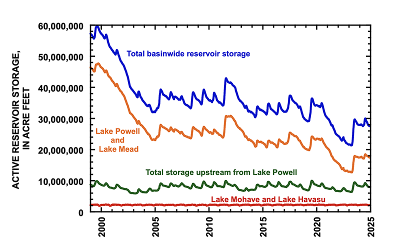
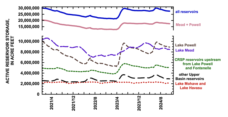
Udall/Overpeck 4-panel Figure Colorado River temperature/precipitation/natural flows with trend. Lake Mead and Lake Powell storage. Updated through Water Year 2024. Credit: Brad Udall
Annual hydrologic variability forces the Upper Basin states to manage uses within the means of the river, which hinders our ability to develop our full compact apportionment. Each year, water managers across the Upper Basin shut off water users when flows are low, adapting uses to the available supply. This is painful to individual Upper Basin water users but is necessary to continue to manage our uses consistent with actual hydrology and the rights and obligations under the 1922 Compact.
As part of the negotiations to establish post-2026 operating rules, we have offered an Upper Division States Alternative, a common-sense, data-driven solution to the Colorado River’s challenges. Our proposal benefits the entire basin by aligning uses and operations with actual water supply and includes voluntary conservation in the Upper Basin. Reclamation has released a description of potential Colorado River water management alternatives to guide development of the post-2026 Colorado River operating rules. We believe the Upper Basin Alternative is within the range of options outlined by Reclamation…Climate change is already here in the Colorado River Basin. Adapting to actual hydrologic conditions, which the Upper Basin does every year out of necessity, can provide a model for equitable and sustainable river use across the entire system. With the current guidelines expiring in 2026, our shared responsibility must be to prioritize the Colorado River’s future by aligning water use with the available supply. It’s time to live within the means of the river we have.
Sessions at this year’s conference, themed “Piecing the Puzzles Together,” were designed to help fit together the various competing interests among Colorado River water users, including tribal, municipal, agricultural, conservation and environmental concerns, said Gene Shawcroft, president of the Colorado River Water Users Association. Climate change and explosive growth in the region have introduced new variability and instability that was not affecting the river when the 1922 Colorado River Compact was signed and require discussions to craft a solution…Water stakeholders across the basin have a responsibility to solve the puzzle for the people of the American West, Shawcroft said. There is also a responsibility to manage the river in an efficient way to ensure its future…
The 1922 Colorado River Compact is still enforced, but the operating guidelines are being negotiated, said Jennifer Pitt, the Colorado River program director at the National Audubon Society. The long-term guidelines, referred to as Post-2026 Operations, will revisit the 2007 Interim Guidelines and other operating agreements that expire in 2026, including drought contingency plans and Minute 323, which allows Mexico to continue to store water in Lake Mead, according to the association’s 2023 report.
Udall/Overpeck 4-panel Figure Colorado River temperature/precipitation/natural flows with trend. Lake Mead and Lake Powell storage. Updated through Water Year 2024. Credit: Brad Udall
Click the link to read the article on the AZCentral website (Brandon Loomis). Here’s an excerpt:
December 6, 2024
State water officials lobbed pointed criticisms at each other on Thursday during successive programs at the Colorado River Water Users Association conference. J.B. Hamby, California’s lead river negotiator, said his state and Arizona won’t keep reducing what they take from the river simply to watch upstream states increase their diversions “and building pipelines to more golf courses.” Brandon Gebhart of Wyoming responded by calling such positions “saber-rattling,” “distractions” and “bullshit.”
[…]
After listening to the back-and-forth on Thursday, a former Interior secretary and Arizona governor said the talks may require a high-level mediator appointed by the White House. That’s what it took to get the states to agree to their initial water-sharing compact in 1922, Bruce Babbitt told The Arizona Republic, and it would help now…Officials from Arizona have begun discussing the option of triggering a “compact call” if that happens, referring to language in the compact that they believe should cause the Interior Department’s Bureau of Reclamation to enforce the compact on behalf of the Lower Basin. Central Arizona Project board members began the week by passing a resolution calling on federal officials to analyze the option of such a compact call…The Rocky Mountain states upstream from Lees Ferry say they already take their share of cuts in low-snow years. Instead of reducing releases from the big reservoirs that the Lower Basin uses, the Upper Basin has to cut back according to what’s flowing down headwater streams. Those reductions average more than a million acre-feet a year, according the New Mexico’s [Estevan Lopez]. The upper states have never approached using their full half, New Mexico compact Commissioner Estevan Lopez said, and aridification has force reductions from a high point of 5.1 million acre-feet.
“It’s highly likely that we in total won’t be able to develop much more than that based on hydrology,” he said.
The future of managing water in the West remains uncertain following the presidential election. But a handful of Colorado River Basin tribes are celebrating a series of new water infrastructure investments from the outgoing Biden administration. Inside a cramped room at a Las Vegas resort, leaders from five federally recognized Southwestern tribes came together during the annual Colorado River Water Users Association conference…
The San Carlos Apache Tribe and Fort Yuma Quechan Indian Tribe, which straddles the Arizona-California border, met with the Bureau of Reclamation to extend water-saving agreements during a signing ceremony on Wednesday. San Carlos has agreed to not withdraw 30,000 acre feet from Lake Mead in exchange for $12 million from the federal government, while Fort Yuma Quechan will collect $5.2 million to leave 13,000 acre feet alone. Colorado River Indian Tribes Chairwoman Amelia Flores signed a letter of intent to fund a $5 million planning study to construct a new reservoir for its main canal through Reclamation’s Native American Affairs Technical Assistance Program, which provides support to develop, manage and protect their water resources…Additionally, the Ute Mountain Ute Tribe, which spans the Four Corners states of Utah, Colorado and New Mexico, signed a repayment contract for the Animas-La Plata Project that has been ongoing for 14 years. It’ll also allocate the tribe 38,000 acre feet of storage in Lake Nighthorse, a reservoir near Durango, Colorado…Lastly, the White Mountain Apache Tribe has been awarded $21.5 million from the Inflation Reduction Act to help plan and design a rural water system to divert, store and distribute water from the White River for some 15,000 residents across the Fort Apache Reservation in eastern Arizona.
Prior to mining, snowmelt and rain seep into natural cracks and fractures, eventually emerging as a freshwater spring (usually). Graphic credit: Jonathan Thompson
Click the link to read the article on the KUNC website (Rachel Cohen). Here’s an excerpt:
December 12, 2024
More than 140,000 abandoned hardrock mines scatter federal lands in the Western U.S. Their cleanup could be getting easier, thanks to a bill that cleared its final hurdle in Congress this week…Finally, this week, the U.S. House of Representatives passed a bipartisan bill called the Good Samaritan Remediation of Abandoned Hardrock Mines Act, which the Senate had already passed this summer. It creates a pilot program under the Environmental Protection Agency that allows nonprofits, governments or landowners to clean up old mines without taking on the risk…
“Historically, the fear of litigation and liability that might trail a would-be ‘good Samaritan’ has kept us from doing a lot of that clean-up work,” said Chris Wood, the president and CEO of Trout Unlimited, which works to remediate mine tailings to improve water quality. Wood said the organization faces obstacles to do as much cleanup as it would like because of the liability concerns. He’s been working to remove these hurdles for two decades.
Bureau of Reclamation commissioner Camille Calimlim Touton (left) smiles at JB Hamby of the Imperial Irrigation District at a conference in Las Vegas on December 4, 2024. The federal government has sent hundreds of millions of dollars to the Southern California farming district to incentivize farmers to use less water. Photo credit: Alex Hager/KUNC
Click the link to read the article on the KUNC website (Alex Hager):
December 14, 2024
Where the farm fields meet the desert in Southern California’s Imperial Valley, farmer John Hawk looks out over a sea of green.
“It really is an emerald gem that we have,” he said. “With the water, we can do miracles.”
The Imperial Irrigation District uses more water from the Colorado River than any other single entity – farm district, city, or otherwise – from Wyoming to Mexico. As climate change shrinks the river’s supplies, its biggest users are facing increasing pressure to cut back on their demand.
“Do we need to conserve? Absolutely,” Hawk told KUNC in 2023. “We need to conserve, but we need to be paid for the conservation.”
Last year, the federal government took Imperial’s farmers up on that suggestion. Over the course of three years, it agreed to send more than $500 million to the district to use less water and leave it in Lake Mead, the nation’s largest reservoir. That money comes from the Biden Administration’s Inflation Reduction Act.
Water leaders in the West and Washington D.C. alike have lauded the effort as a pivotal way to boost the reservoir, which has dropped to all-time low levels in recent years. Similar spending has saved water on farms and tribal land across the region. It has also made city utilities more efficient. But now, on the cusp of Donald Trump’s return to the White House, those who use the river’s water are worried that funding could disappear.
“All these programs cost money,” said Gina Dockstader, a fourth-generation farmer who sits on the Imperial Irrigation District board of directors. “All this investment, all this infrastructure costs money, and without these additional funds, these farmers can’t afford to put it in by themselves.”
John Hawk, a farmer in California’s Imperial Valley, walks across an irrigation canal on June 20, 2023. “We need to conserve, but we need to be paid for the conservation,” he said. Photo credit: Alex Hager/KUNC
The federal government needs to keep water in Lake Mead and the nation’s second-largest reservoir, Lake Powell. Without conservation, water levels could drop low enough to cause the shutoff of massive hydropower generators. Even lower water levels could make it impossible to send water from big reservoirs to the Colorado River on the other side of the dams that hold them back.
When the Biden Administration set aside $4 billion of the Inflation Reduction Act for Colorado River work, it lifted some weight off the shoulders of anxious water managers, who could use it to incentivize water conservation and stave off catastrophe at those reservoirs.
Those measures also bought time for negotiators working on new, long-term rules for sharing the river’s water. Nevada’s top water negotiator, John Entsminger, called the federal spending a “once-in-a-generation windfall.”
On the campaign trail, then-candidate Donald Trump said he would claw back unspent funds from the Inflation Reduction Act. That could jeopardize the expensive programs that have brought a wave of temporary peace and certainty for the Colorado River basin.
“It would be really disappointing if that went away,” said Hannah Holm with the conservation group American Rivers. “People are pretty pessimistic.”
American Rivers receives funding from the Walton Family Foundation, which also supports KUNC’s Colorado River coverage.
Holm said the need for water conservation, and funding to make it possible, will only get more important in the future. Climate change is expected to keep shrinking the amount of water in the river and necessitate more cutbacks to the region’s water use.
“If that funding doesn’t materialize,” she said, “We just won’t be as able to adapt as well to the conditions we already have, let alone the conditions that are coming our way.”
The Biden Administration’s infrastructure funding reached a wide variety of water-related projects. Holm cited forest restoration work that helps decrease the likelihood of forest fires, which can add dirt, ash, and harmful debris to rivers that supply drinking water.
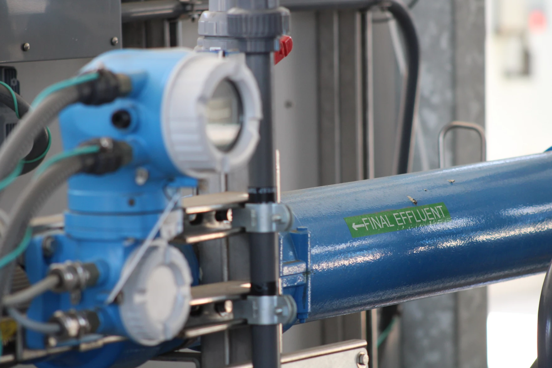
A pipe carries treated wastewater out of a water recycling demonstration facility in Carson, California on May 26, 2022. Cities are modernizing their water treatment systems to make them more efficient, often with the help of federal funding. Alex Hager: KUNC
City facilities that treat water for drinking were also on the long list of entities that received federal funding under the Biden Administration.
In the Los Angeles area, for example, the Metropolitan Water District of Southern California is spending massive amounts of money on equipment that will help steel its network against future water shortages. That agency is spending more than $3 billion on a water recycling facility, where it will safely turn sewage back into drinking water instead of cleaning it to a lower standard and releasing it into the ocean.
“In the long run, it’s going to be vital for us,” said Deven Upadhyay, Metropolitan’s interim general manager. “In the short run, it looks to be pretty expensive compared to the other resources we have. So the federal dollars really do help.”
Meanwhile, as farms and cities tighten the screws on their water use, the negotiators shaping the big-picture future of the Colorado River are stuck at an impasse. The seven states that use its water are split into two camps, divided by deep ideological differences about who should cut back on their water use going forward.
State water officials are projecting optimism that Trump’s second term will not shake up their talks, citing a historical precedent of stability within federal water agencies that is mostly unaffected by turnover in the White House.
Holm said the future they are negotiating, though, will look different if there is less federal money to ease the pain of water reductions.
“In order to be able to make less water do more,” she said, “We need to be able to manage it a lot more precisely. That takes investment in science, in infrastructure, in monitoring, in figuring out different ways of moving water around. And none of that happens by itself.”
This story is part of ongoing coverage of the Colorado River, produced by KUNC in Colorado and supported by the Walton Family Foundation. KUNC is solely responsible for its editorial coverage.
Map of the Colorado River drainage basin, created using USGS data. By Shannon1 Creative Commons Attribution-Share Alike 4.0
One of the hopeful notes coming out of the recent Colorado River discussions is the way the operation of Glen Canyon Dam in a more flexible way, to accommodate a broader range of values, is back on the table. The USBR alternatives released ahead of this week’s Colorado River Water Users Association, while requiring some tea leaf divination because of their brevity, seem to leave the door open for this discussion.
Jack Schmidt and I have a new white paper offering some assistance, based on our understanding of the legal and regulatory structure around Grand Canyon National Park and Glen Canyon National Recreation Area. The idea behind what we’re arguing isn’t to wag a regulatory finger and say, “The law requires us to do X.” Rather, we’re saying, “The law enables us to do X,” where for “X” we argue for the consideration of a wider range of social, cultural, and environmental values as we make decisions about how to divide the water up between Lake Mead and Lake Powell.
Rains, locally heavier, fell across roughly the east half of Texas this week, with heavier amounts (locally 4-7 inches) falling in parts of the central Gulf Coast region. Lighter precipitation amounts fell in parts of Mississippi, Alabama, Georgia and Tennessee, and in the Ohio River Valley. Snow, some of it lake effect, fell in parts of the Upper Great Lakes, and heavier lake effect snow fell downwind from Lakes Erie and Ontario. Most of the Great Plains and West was dry this week, except for high elevation areas of western Montana and northern Idaho and in western parts of Oregon and Washington. Degradations in drought conditions occurred in southern California and southern Nevada, parts of high elevation Wyoming, across portions of the Mississippi River Valley, in the Florida Peninsula and in parts of Texas. Generally drier weather in Hawaii led to widespread degradations as well, mostly on the windward sides of the islands. Improvements occurred in parts of east and deep south Texas, western Montana and central Washington, Mississippi, Alabama, Georgia and Tennessee, in the Upper Peninsula of Michigan and northeast Minnesota, and in Erie County, Pennsylvania and southwest and south-central New York…
Except for parts of the Front Range of the Rocky Mountains in Colorado, weather across the High Plains region was mostly dry this week. Temperatures were primarily warmer than normal, ranging from 3-12 degrees above normal in most areas (with locally warmer readings). Drought and abnormal dryness coverage remained mostly unchanged. Moderate drought coverage was reduced southwest of the Denver area as precipitation deficits lessened there. Abnormal dryness was also removed from west-central Kansas after conditions were reassessed there following wetter-than-normal weather over the last couple of months. Well-below-normal early season snowpack and short- and long-term precipitation deficits led to expansion of extreme drought in parts of the Wyoming, Wind River and Bighorn mountain ranges in Wyoming. Water usage is currently restricted to essential use only, due to low well levels, in the communities of Auburn and Peru in southeast Nebraska, where moderate drought is ongoing…
Colorado Drought Monitor one week change map ending December 10, 2024.
Primarily dry weather occurred in the West this week, except for western Washington, western Oregon, western Montana and northern Idaho. Most of the West finished this week either within 5 degrees of normal or 5-10 degrees warmer than normal. Central and eastern Montana saw widespread temperatures range from 10-15 degrees above normal. Widespread improvements to drought conditions occurred in western Montana and adjacent Idaho due to lessened short- and long-term precipitation deficits and increased soil moisture. In central Washington, small adjustments (both improvements and degradations) occurred in abnormal dryness and moderate drought areas where streamflow amounts and short- and long-term precipitation deficits changed. Short-term precipitation deficits continued to mount in southern and central Nevada and in southern California, leading to expansion of drought and abnormal dryness areas there…
Widespread rains fell across parts of the south this week, especially in eastern Texas, Louisiana, Mississippi and western Tennessee, while the rest of Texas, most of Arkansas, and Oklahoma remained mostly dry. Western Texas was mostly 3-9 degrees warmer than normal, while Mississippi was mostly near normal or 3-6 degrees below normal. In between these areas, temperature anomalies varied but were mostly within 3 degrees of normal. Due to lessened precipitation deficits and increased streamflow and soil moisture, drought areas were reduced in coverage in central Tennessee, parts of Mississippi, western Louisiana and parts of east Texas. Short-term precipitation and streamflow deficits continued to build in northeast Arkansas, leading to widespread expansion of abnormal dryness and moderate drought there. In parts of southeast and south-central Texas, conditions worsened where soil moisture and streamflow deficits grew amid growing precipitation deficits. In far southern Texas, heavy rains led to local improvements near the mouth of the Rio Grande. In Bexar County, Texas, certain types of fireworks were temporarily banned from sale or usage due to ongoing drought conditions, while lake and reservoir levels dropped to 20% capacity in the Corpus Christi area…
Looking Ahead
Through the evening of Monday, Dec. 16, the National Weather Service Weather Prediction Center is forecasting at least an inch of precipitation in the middle Mississippi River Valley, lower Ohio River Valley, western Tennessee, northwest Mississippi, eastern Texas, southeast Oklahoma, northern Louisiana and Arkansas. Precipitation of at least 1 inch is also forecast in parts of eastern New England and in a few areas downwind (east) of lakes Erie and Ontario. Heavy precipitation is also forecast in northern and northwest California and southwest Oregon, where locally up to or over 5 inches of precipitation is possible. At least 1.5 inches of precipitation is also forecast in many areas of western Washington and Oregon, while mostly lesser amounts are forecast in eastern Washington and Oregon and in parts of Idaho. The Southwest, western Great Plains, southeast Alabama, southern Georgia and the Florida Peninsula are forecast to remain mostly dry.
The National Weather Service Climate Prediction Center’s 6-10 day forecast, covering December 17-21, favors warmer-than-normal temperatures across almost the entire U.S., except for eastern Missouri, Illinois and parts of the Upper Midwest. Forecaster confidence is high for above-normal temperatures in the West, New England, southern Alaska and Hawaii. Precipitation amounts are likely to be below normal for this period across most of the central and northern Great Plains and the West, except for northwest Washington and Oregon, where above-normal precipitation is slightly favored. Above-normal precipitation is also favored in central and southern Texas, the Florida Peninsula, and the Atlantic Coast. Above-normal precipitation is also favored in southern Alaska, while drier-than-normal weather is favored in northern Alaska and in Hawaii.
US Drought Monitor one week change map ending December 10, 2024.
Congress can pass historic legislation to ensure three Tribes have the water they need to sustain their homelands
The Navajo Nation, the Hopi Tribe, the San Juan Southern Paiute Tribe, and other parties in Arizona have come to an historic agreement with the settlement now before Congress. The Northeastern Arizona Indian Water Rights Settlement Act of 2024—when passed by Congress and signed by the President—will ensure a reliable water supply for these Tribes in northeastern Arizona and the region.
The agreement will do this in part by managing groundwater in the region, by settling long-running claims among in-state parties and the Tribes to the Little Colorado River, and by settling Tribal claims to water from the Colorado River.
The settlement is the result of innovative and creative thinking among the Navajo Nation, the Hopi Tribe, the San Juan Southern Paiute, and other non-Tribal parties. The settlement provides flexibility for the Tribes to distribute water to their people. We note concerns raised by representatives of the states of Utah and Wyoming regarding the potential for this settlement to allow, within the state of Arizona, delivery of Colorado River water across the Upper Basin – Lower Basin divide. The Navajo Nation’s water management challenges are many; this geographic feature should not be one of them. Approving the settlement with this provision is crucially important to the Navajo Nation and should not be considered to set a precedent for other parties.
The settlement not only replaces conflict over scarce water resources with cooperation, but it will also provide five billion dollars in funding to the Tribes so that they will be able to deliver safe and reliable drinking water to tens of thousands of people. This settlement is vital to the Navajo people because:
Roughly a third of the Navajo Nation households lack running water.
The average cost for Navajos to haul water to their homes, ranches, and sheep camps is $133 per thousand gallons, about 70 times more than the cost paid by other water users in Arizona. Without the settlement, thousands of Navajos will continue to haul water an average of more than 30 miles round trip to meet their daily water demands.
The settlement provides certainty on the Colorado River to the benefit of all the 39 settling parties.
It is long past due for these three Tribes to have the water they need to sustain their permanent homelands. Arizona, and the entire Colorado River Basin, will benefit from the certainty provided from this water settlement.
Audubon’s focus on birds means we also prioritize the protection of the habitat they need. Riparian and riverside habitat is of outsized importance for birds and other wildlife. This habitat relies on healthy groundwater levels to sustain flowing rivers and streams and the rich plant life and wildlife they support. Groundwater sustains seeps and springs that provide not only water supplies to people, but also valuable habitat to birds and other wildlife. Likewise, the Colorado River and the Little Colorado River are lifelines in an arid environment. This settlement will help protect these precious water resources.
In Navajo “Tó éí iiná até” means “with water, there is life.” At Audubon, we are guided by what birds tell us; and this is why much of our conservation work is targeted at finding win-win solutions for water for people and birds. We urge Congress to support the advancement of S. 4633/H.R. 8940 this session. This water rights settlement is crucial to ensuring the continued and the increased vitality of the Navajo Nation, the Navajo people, and all the Tribes and people in the Colorado River Basin who will benefit from this historic settlement.
The Powell-Ingalls Special Commission meeting with Southern Paiutes. Photo credit: USGS
Call it a meeting of the minds – Willem A. Schreüder, the CU computer scientist behind the groundwater modeling of the Upper Rio Grande Basin, and a group of San Luis Valley irrigators who are racing against time to reduce groundwater pumping in what state water engineers call “one of the most productive irrigated farming areas in the state.”
Schreüder spent more than an hour at a Dec. 4 meeting with farmers who form the governing board of Subdistrict 1 of the Rio Grande Water Conservation District. They wanted to know if the subdistrict’s upcoming Fourth Plan of Water Management, which calls for irrigators to limit their groundwater pumping to the amount of surface water that naturally flows in, is going to work.
It’s called one-for-one pumping, and while the plan has been approved by the Subdistrict 1 board, the Rio Grande Water Conservation District board and the state engineer, it still needs sign off from the state water court, which likely won’t happen until 2026.
While all the Valley’s farmers face pressure to reduce groundwater pumping in the face of a changing climate, it’s the crop producers in Subdistrict 1 who are on the clock and under state orders to recover groundwater levels of the unconfined aquifer and maintain a sustainable irrigation water supply by 2031.
It’s Schreüder’s mathematics’ modeling that clues in the Colorado Division of Water Resources to the response the river system and aquifers are having through a steady reduction of groundwater pumping over the past two decades.
Schreüder’s expert witness testimony explaining the Rio Grande Decision Support System (RGDSS) model has been the subject of state water court proceedings and undoubtedly will be again in upcoming cases.
His session with Subdistrict 1 managers yielded a few insights, notably:
The recharge of streams should occur as close to the point of where the groundwater pumping occurred, a problem that has particularly come to light around Saguache Creek and the groundwater pumping that occurs in that area of the Valley.
As much as the RGDSS model can be useful in showing the response of the river to less groundwater pumping, there is always an imbalance even if irrigators are perfectly recharging the same amount as they’ve pumped out.
What follows is a partial, edited transcript of the conversation to get at some of the more pertinent questions. Jake Burris, president of the Subdistrict 1 board of managers, opened the discussion:
Burris: The first question I would throw at you is, the anchor of the amended plan, should we be successful, is that we would only pump imported water as it’s brought in. Live within our means, sort of speak. If that is the case, is it unreasonable to assume that we would not be generating any new depletions at that point?
Schreüder: New depletions anywhere, or a particular stream?
Burris: Anywhere, any stream.
Schreüder: So the short answer is ‘No’ in the sense that yes, we probably still will have the depletions, and what it comes down to is that the one-for-one plan essentially is one that deals with an average. So we’re looking at a districtwide or subdistrict-wide average balance, whereas when we talk about stream depletions, we’re talking about time, place, amount. And so it’s very easy to construct a hypothetical situation where if you look at where the pumping occurs and where the recharge occurs, that those recharges in pumping are not exactly coincident and as a result, the distance between where you recharge and where you are pumping basically directs depletions to a particular direction. And so what could very likely occur is that on one stream you actually have an accretion and on another stream you have depletion. So on average you tend to be sort of in balance with the surface network, but the people on the stream that is depleted, are not going to be happy. . .So unless the way that the one-for-one works is that the recharge occurs in exactly the place where the pumping occurs, you likely will have depletions to some streams.”
Burris: So it’s not just simply an issue from an administrative standpoint of us utilizing our recharge on an average. That’s irrelevant. It is a logistics and timing problem, regardless?
Schreüder: There’s both a temporal and spatial component to that. Think about for example, the depletions to the Rio Grande and I’m making up numbers here, but just to make the argument easier, let’s say 50 percent of your depletions occur in year one and then 30 percent in year two and 10 percent in years three and four. So it’s front-loaded as far as when the depletions occur, and you’re working on a five-year average and let’s say for those first five years, or first four of the five years, let’s say there’s negative 25,000 acre-feet of pumping to managed recharge. . .and then in the last year, year five, we basically have a 100,000 acre-feet of pumping in excess of recharge. So because half of that occurs in year one, and the offsets from two years and three years and four years and five years ago are lesser amounts, even though on the five-year average you are in balance, you could have a situation that on the Rio Grande in that first year after the big pumping you do not have an impact. So it’s both the temporal scale at which things happen, as well as the spatial scale. It’s also a reflection of where did that recharge occur and where did the pumping occur. If you average it out, they don’t fall right on top of each other.
Burris: The way the model then is I guess essentially looking at it for lack of a better way, but from a temporal and spatial standpoint, Sub 1’s aquifer itself is irrelevant. It’s not looking at it from a form of recharging an aquifer as a whole and recharging for all the wells as a conglomerate. It’s looking at the individual wells and the areas around each well?
Schreüder: As far as the model is concerned, yes.
Burris: I think that’s our big disconnect, or at least I should speak for myself there. The way Sub 1’s structured is with the way the aquifer system is and the way we treat the wells and recharges, it’s in totality. It’s as a conglomerate, and so you can’t take that perspective in any way to the model?
Schreüder: That’sright? And so there’s actually three parts to this. The first is as far as Subdistrict 1’s one-for-one is concerned, to a large part that’s going to address sustainability because what you put in and what you take out balances, that should be sustainable. So that’s the one part. The other part then, of course, is the groundwater modeling, which tries to figure out just exactly where the spring depletions occur. And then the third part to that is well, we need to calculate these response functions and the response function needs to capture the essential behavior of the model so that we have a simpler way of actually applying the inputs and predict what the depletions are. The problem that we are going to face in the future is that so far the response function approach has actually worked pretty well because what we found is that if you simply look at what the imbalance between pumping and recharge is in the ’90s and early 2000s, it did a pretty good job of predicting where the stream depletions would be if all you do is to calculate the net consumptive use and you run it through that function, and then you get the stream depletion prediction. But what if we go one-for-one and the next CU (consumptive use) is zero a lot of time, how are we going to figure out a response function that we can then use to predict what the stream depletion is?
Burris: It is a possibility to reconsider conceptually how the model is I guess, the framework of the model? Or are we pretty much stuck with how the system is now, if that makes sense?
Schreüder: I think we are fairly confident in the framework of the model because it is able to reproduce what has happened historically pretty well. The question that we’re struggling with is ‘How do we ask the what-if question?’ Had there not been wells or had the wells only operated in a way where the pumping matched the recharge, what would the stream depletions have been? And that’s a little bit more tricky question that we need to answer now. In the past, because there was always an imbalance between pumping and recharge, it sort of worked out. But if we are actually finding that we are leaving the response function zeros a lot, and if the model does all of the superimposition of individual wells in terms of one answer, and then we average things and we run that sort of the response function, we don’t come up with that same answer, that’s the problem, right? That’s the definition of non-linear. Linear means if you have a function that translates an input to an output, all you have to do is average the inputs and the function will give you the same average on the outputs. Whereas in the non-linear system, if you run the individual items through the function and you then average the results, you don’t get the same answer. And that’s what we are struggling with. Will we be able to properly linearize that?
Burris: I’ll throw one more question at you and then I’ll let somebody else talk. What is the difference in impacts specifically, I’ll say, to Saguache Creek as far as the model sees them between unconfined wells and confined wells? Is the classification different in the model? Is the impact different, or are those treated the same sort of like we treat them the same in Sub 1?
Schreüder: They’re different in the sense that, because in the confined aquifer you typically have lower storage co-efficients, the columns of depression that accumulate for those tend to spread out wider and faster than they do in the unconfined aquifer. And so since the model basically just stacks all of those on top of each other and then calculates the total, it takes into consideration the fact that confined and unconfined wells behave differently. But as far as, can you tell me exactly how confined wells are, what the total is from confined wells and what’s the total from the unconfined wells? I’ve not tried to make that separation. We always just consider it in total because again, this is a non-linear system. So how you evaluate individual wells versus all of the wells in the subdistrict as a whole, if you add up all the individual wells, it doesn’t add up to the total for the subdistrict as a whole. So it’s a little difficult to make that clear distinction between the two.
Credit: Rio Grande Water Conservation District
The seventh iteration of the RGDSS model is being finalized by Schreüder, which led to this exchange with another of the Subdistrict 1 managers. The conversation also then delved into the new Southern Colorado Water Conservancy District.
Sub1 Board: When will we have, ‘This is the final seven version?’ Do we need to take action soon or can we wait a month or two for you to finalize it?
Schreüder: So I am hoping, we have a meeting on Dec. 17, I think is the date, and I’m hoping to finalize the model for that, or at least get people’s agreement that this is good enough that we should be moving on to the application of the model. So now we start asking the model questions, and it’ll probably be several months if not a year before we go from OK, we now have a model’ translating that into, do we ask the right question for each zone and then what are the response functions that are coming out of that? So it’s probably going to be at least a year before we have the answer that will apply for the next five or 10 years.
Sub 1 board member, on the Sustainable Water Augmentation Group known as SWAG: SWAG forming their own subdistrict and I guess trying to do it alone, how would you see that changing those fields and their new conservation district now outside of our subdistrict. Would that impact this data set?
Schreüder: Well, I guess to the extent that they do their own thing, they give us more site-specific information, we’ll try to incorporate that into the model. The difficult thing that we need to figure out is, ‘How do we deal with it separate from the rest of Sub 1?’ And that’s not going to be easy.
Sub 1 board member: Just clipping those wells out of our dataset, you’re saying it’s not just as straightforward as, ‘Hey, these ones are closer to Saguache and they’re no longer in the map.’ Does that help the math?
Schreüder: Well, and I mean that’s part of the problem, right, is it’s sort of obvious that yeah, those guys are probably having a bigger impact on Saguache Creek than the rest, but how do we actually run the model in such a way that we can actually quantify that? And that’s one of the problems that you have an nonlinear system, is if you start breaking it up into lots of little parts, the answer doesn’t sum up to the total and that becomes problematic in terms of how do you figure out what the total impact on the stream is and how to distribute that back to individual people? And it’s something that we’ve worked very hard to avoid, but they’re sort of forcing our hand and I don’t know exactly what the answers can be.
Sub 1 board member: You mentioned the substantial decrease in pumping over the last 10, 15 years in Subdistrict 1. Is there a scenario where if that were to continue or if wells were continuing to be retired in Sub 1, that that cone of depression would no longer reach Saguache Creek or we would no longer have applications in any scenario?
Schreüder: It’s that balance, right, between where the recharge occurs and where the pumping is. So if we basically do one-for-one and we can put the recharge exactly where we’ve pumped, then there should be no net cone of depression. And so that’s the problem, right? There’s always an imbalance, and so even if you are perfectly recharging the same amount as you are pumping, it’s always going to push the cone of depression in one direction.
Jake Burris: I once again will reiterate how appreciative I, and we are, that you’re willing to make the trip down here and talk to us. It was hugely helpful, at least for me, just the general perspective o,f it’s drastically different how we treat Sub 1 and administer it versus how the model sees it, I guess is how I’ll put it. But we do appreciate you taking the time.
Schreüder: Well, and again, let me just reiterate. The sustainability requirement, there’s the model’s predictions of impact, and then the response functions themselves, and the way that the response functions work right now, by definition, if you had no net CU (consumptive use), there would be no depletion. But that’s the existing response functions, and that’s one of the things that we need to figure out at the end of phase seven is, OK that particular model of response function is probably not going to work again. So what are we going to do to fix that?
NASA satellite images show water decline in Lake Mead from 2000, at left, to 2022, the largest reservoir in the United States. Credit: Colorado State University
Click the link to read the article on the InkStain website (John Fleck):
My colleagues with the Colorado River Research Group have a new policy brief out today taking another whack at the question of “assigned water” – water kinda sorta conserved, but left in storage so water agencies can pull it out again at some future date. Think “Intentionally Created Surplus” (ICS). At this point, nearly 40 percent of the water in Lake Mead is tagged as some agency’s private storage account, rather than being available for general system use.
This is the issue Arizona State’s Kathryn Sorensen (one of my CRRG colleagues) has been raising, and that Kathryn (with help from Sarah Porter and I) wrote about in October. The new CRRG paper argues that, as we move toward expanding the assigned water programs available to basin water users, we need to be mindful of the risks.
Map of the Colorado River drainage basin, created using USGS data. By Shannon1 Creative Commons Attribution-Share Alike 4.0
Drawdown of the Colorado River’s reservoirs now slightly exceeds the amount of gain that occurred during the 2024 snowmelt season. For the next four months until snowmelt begins again, the basin’s reservoirs will be drawing from the excess accumulated in 2023, demonstrating the immense challenge in balancing water consumption with supply.
In Detail…
On 30 November 2024, total basin reservoir storage was 27.5 million af (acre feet)1, approximately two years’ supply at today’s rate of consumptive use and loss (Fig. 1). That amount is 43% of the maximum system contents of July 19832 and is the same amount as at the beginning of July 2021 when the basin’s water managers were beginning to get worried. Conditions are not quite as bleak as in summer 2021, because that year’s snowmelt season had already passed. Now, we can hope that the 2025 snowmelt season might be a good one. Nevertheless, reservoir storage is the bank account from which we draw to maintain the economy of the American Southwest and parts of northwestern Mexico. It would be preferable for there to be more water in that account.
Figure 1. Graph showing total storage in 46 reservoirs (blue line) in the Colorado River basin since 1 January 1999. Also shown are the total contents of Lake Mead and Lake Powell (orange line), total contents of Lake Mohave and Lake Havasu (red line), and 42 reservoirs upstream from Lake Powell (green line) which includes reservoirs managed by the federal and state governments, municipalities, and water districts. Credit: Jack Schmidt/Center for Colorado River Studies.
Approximately 63% of current total reservoir storage is in Lake Mead and Lake Powell. Presently, there is approximately 400,000 af more water in Lake Powell than in Lake Mead, but the contents of Lake Powell are slowly being depleted. The contents of Lake Mead held fairly constant during the past month. The contents of Lake Powell decreased by approximately 4300 af/day during November, but the contents of Lake Mead decreased by only 800 af/day (Fig. 2). Upstream from Lake Powell, Colorado River Storage Project (CRSP) initial unit reservoirs, as well as Fontenelle Reservoir, decreased by only 600 af/day in November, and other Upper Basin reservoirs lost even less (400 af/day).
Figure 2. Graph showing total basin reservoir storage (blue line), and storage in different parts of the Colorado River watershed between 1 January 2021 and 30 November 2024. Credit: Jack Schmidt/Center for Colorado River Studies
Basin reservoir storage must be increased to improve the security of our water supply. We need to increase the balance in our “bank account,” and the only way to do that is to spend less than the amount of our actual water “income.” Most of our income arrives during the snowmelt season of late spring and early summer. Mid- and late-summer, fall, winter, and early spring is the period when we spend the snowmelt-season income, although summer rains and groundwater inflow offset some of our uses.
Occasionally, we have an unusually snowy winter, and the basin’s reservoirs significantly refill. 2023 was one of those years. Reclamation estimates that the natural flow of the Upper Basin3 was 17.4 million af in 2023, the third largest of the 21st century (after 2011 and 2019), and total basin storage increased by 8.38 million af, only exceeded by the increase in storage in 20114. 2024 was a moderately snowy winter.
2024 was a different story, however. The NRCS estimated that the peak snow water content in 2024 was 14% greater than the 30-year average, but dry soils and other effects of a warming climate limited natural flows to between 11.9 and 12.1 million af, which is less than the average for the 21st century5. In 2024, the basin’s reservoirs increased in storage by 2.45 million af. The drawdown of the basin’s reservoirs as of 30 November was 2.46 million af, slightly more than the gain from snowmelt (Fig. 3). The contents of Lake Mead and Lake Powell increased by 1.39 million af in 2024, and the drawdown in those two reservoirs has been 1.07 million af this year. During the next four months, the basin will begin drawing from storage that accumulated in 2023.
Figure 3. Graph showing reservoir storage between 1 January 2023 and 30 November 2024, highlighting the amount of reservoir recovery during the past two snowmelt seasons and the amount of intervening reservoir drawdown. The drawdown of the basin’s reservoirs since July 2024 slightly exceeds the recovery that occurred due to snowmelt in 2024. Credit: Jack Schmidt/Center for Colorado River Studies
Drawdown of the basin’s reservoirs has been much greater in 2024 than in 2023. The amount of drawdown between early summer and today is slightly more than the median drawdown for the past 15 years6 and is 43% greater than the drawdown at this time last year (Table 1). The drawdown of Lake Mead and Lake Powell in 2024 is slightly less than the median for the past 15 years7 but is 98% greater than it was at this time last year.
The total reservoir drawdown between early summer and 30 November is now 14% greater than in all of last year, and drawdown in Mead and Powell also exceeds the total drawdown in those reservoirs last year (Table 2). We did well last year, but not so well this year. Credit: Jack Schmidt/Center for Colorado River Studies
Credit: Jack Schmidt/Center for Colorado River Studies
There are many details ignored in this overview. Reservoir drawdown in the Upper Basin is not only determined by consumptive use, but also by reservoir operating rules that require winter drawdown and by requirements to provide environmental flows. Water use in southern California is significantly affected by water supply available from northern California, the Owens River, and locally. Nevertheless, every drop of water released from upstream is used, lost, or stored in a downstream reservoir, and total basin storage is the only available supply to make up the shortfall between annual precipitation and annual use.
Conservation in the Lower Basin and in Mexico is reducing drawdown in Lake Mead, and the storage contents of Lake Mead are likely to increase during the next few months as water is delivered from upstream. Drawdown of the total contents of Lake Mead and Lake Powell is still 0.32 million af less than what accumulated there from the 2024 inflow season and a 2024 deficit might not occur is Lower Basin water use is drastically reduced or if Upper Basin reservoirs are emptied.
Efforts to date to reduce water consumption in the basin have been significant, and required a significant investment by the federal government. Despite those efforts, we have four months ahead of us before snowmelt in 2025 begins, and we are likely to begin deficit spending unless radical changes in use are immediately implemented. The challenge faced by the federal government, Mexico, the seven basin states, every tribe, and every water user is immense and is not solely restricted to negotiating the post-2026 agreements. We remain in a water crisis today, and the time to greatly reduce water consumption is right now in the present moment. [ed. emphasis mine]
[2] There was 63.6 million af of storage in the basin on 15 July 1983. Some of this storage exceeded the generally accepted capacity of some reservoirs, notably Lake Powell.
[3] at Lees Ferry
[4] Basin reservoir storage increased by 8.78 million af in 2011.
[5] Natural flows for calendar year and water year 2024 were 12.1 and 11.9 million af, respectively, based on Reclamation’s 12 September 2024 estimate. The average natural flow at Lees Ferry between 2000 and 2024 was 12.4 million af/yr, based on Reclamation’s estimates.
[6] The median drawdown between the summer peak and 30 November during the past 15 years was 2.26 million af for the 46 reservoirs of the watershed.
[7] The median drawdown between the summer peak and 30 November during the past 15 years was 1.16 million af for the total contents of Lake Mead and Lake Powell.
[8] Includes drawdown of Lake Mohave and Lake Havasu.
To consider how climate change could cause some extinctions, imagine a tiny mountain bird that eats the berries of a particular mountain tree. That tree can only grow at a specific elevation around the mountain, where it’s evolved over millennia to thrive in that microclimate. As global temperatures rise, both the tree and the bird will be forced to rise too, tracking their microclimate as it moves uphill. But they can only go so far.
“Eventually, they reach the peak, and then there’s nowhere else to go,” says Mark Urban, a biologist at the University of Connecticut.
Scientists call this mountain phenomenon the “escalator to extinction” and it’s just one way climate change is already squeezing plants and animals from their habitats. Researchers have conducted hundreds of studies projecting how different species might respond to different levels of climate change, finding varied results. In an analysis published Thursday in the journal Science, Urban sought to bring all those studies together…If countries meet the shared goal of limiting warming to 1.5 degrees Celsius, 1.8% of species will be at risk of extinction by the end of the century, Urban reports. But if global warming gets out of hand, warming four or five degrees Celsius, as many as 30% of species could be at risk…He points to confounding complexities in how species might respond to such climate extremes that scientists don’t yet know. More critters may simply not be able to cope, or ecosystems that lose species after species may collapse altogether. Additionally, many rare species are understudied, or not even discovered, and might be especially vulnerable in ways that don’t show up in this analysis…Different species face some different risks. Amphibians, including frogs and salamanders, are more vulnerable, Urban found, perhaps because their habitats are more sensitive to environmental changes. Species that live on islands, mountains and in freshwater could face more challenges, too. Targeted conservation efforts could help slow losses, Urban says, but they’re ultimately no substitute for reducing emissions.
Western states that rely on the Colorado River are in a heated deadlock over how to manage the troubled river, and are doubling down on their own regional plans, despite growing pressure from the federal government to reach a compromise.
Top water officials for the seven Colorado River Basin states — Arizona, California, Nevada, Colorado, New Mexico, Utah, and Wyoming — gathered for the Colorado River Water Users Association conference at the Paris Hotel and Casino in Las Vegas Thursday.
But for the first time in years, representatives from Lower Basin states — Nevada, Arizona, and California — and Upper Basin states — Colorado, New Mexico, Utah, and Wyoming — did not appear on a panel together or meet during the conference to negotiate the future of the Colorado River.
“It’s been customary that we get together beforehand,” said Colorado River Commissioner for Colorado, Becky Mitchell, during a news conference. “Unfortunately, we weren’t able to do that. I don’t think that means that we will never be able to do that again. It just means this time we weren’t.”
Map of the Colorado River drainage basin, created using USGS data. By Shannon1 Creative Commons Attribution-Share Alike 4.0
Nine months ago, the two basins submitted competing water management plans to the federal government after state negotiators could not reach a consensus on how to share the river’s dwindling water supply.
Since then, the basin states have not moved any closer to negotiating a compromise on how to equitably share and cut Colorado River water use once current management rules expire in 2026, leaving states up a creek without a paddle.
One of the biggest sticking points between the two basins is whether or not Upper Basin states should absorb mandatory water cuts during dry years, despite using significantly less than their 7.5 million acre-feet Colorado River allocation year-after-year.
Historically, Lower Basin states have used nearly all their 7.5 million acre-feet Colorado River allocation under the 1922 Colorado River Compact, compared to the 4.5 million acres-feet used by the Upper Basin states.
Lower Basin states argued all seven states should share water cuts during dry years under the new post-2026 guidelines. If they don’t, downstream states warned they could face water cuts they can’t feasibly absorb.
Those tensions were reflected Thursday when Lower Basin water managers told a ballroom full of water managers, researchers, agricultural producers and others from across the drought-stricken river that if their Upper Basin counterparts did not sign onto the Lower Basin plan and accept cuts, they would be at greater risk of triggering a “compact call,” which could force cuts on the Upper Basin.
Upper Basin states argue they don’t have the legal authority to significantly reduce flows to water users on their own under the 1922 Colorado River Compact, unlike Lower Basin states.
“They might have that authority if we make a compact call. So perhaps we’ll make that compact call, then they’ll have the authority to cut flows,” said Tom Buschatzke, Arizona’s top Colorado River negotiator. “Maybe that’s an easy path compared to going to their water users with some voluntary program or their legislatures to get authorities to do the things we have to do in the Lower Basin.”
In September, Buschatzke asked Arizona Gov. Katie Hobbs to set aside $1 million for litigation in the event states can’t reach a compromise and Arizona needs to take the issue to court.
“I have to do my due diligence for all potential outcomes,” said Buchatzke about his request.
Negotiators in both the Lower and Upper Basin states all acknowledged they have three options to decide how states will share the river’s waning water supply going forward: litigation, legislation or negotiation.
“When we put forward our Lower Basin alternative, we were looking to offer a compromise,” said JB Hamby, Colorado River Commissioner for California. “We want a seven state agreement. We don’t want to have to go litigate stuff and force these really difficult outcomes in the Upper Basin.”
Mitchell, the Colorado River Commissioner for Colorado, was critical of how the Lower Basin states have approached negotiations with the Upper Basin.
“I think going in, not willing to change your deal at all, is probably the first problem. You cannot say there’s a compromise, if we have to accept a deal in its entirety,” Mitchell said, adding that Upper Basin states are open to adjustments to their plan.
To spur a compromise, the federal government released an initial outline detailing four different river management options last month, including a hybrid management option that blends components from both basin state plans.
Representatives for both camps said they would need to see more details before throwing their weight behind any of the federal management proposals.
“They did provide a bit of additional information today as to some of the elements, but still not enough,” said Estevan Lopez, New Mexico’s representative on Colorado River matters, during a news conference Thursday.
Representatives for the U.S. Bureau of Reclamation said the agency intends to publish a more detailed analysis of the federal proposals by the end of the year. Maximum cuts could range from 2.1 million acre-feet to 4 million acre-feet, which could be divided based on who has the oldest rights, or distributed proportionally across all seven states.
Despite the lack of comradery among the Lower and Upper Basin states at the annual conference, both camps expressed optimism they could reach a compromise, eventually.
“I want everybody from the upper basin to hear from Nevada: We believe compromise is possible. We think it’s the first, second and third best option. But we need a dance partner, so let’s get back to the table and make this happen,” said John Entsminger, Nevada’s representative on river issues and general manager of the Southern Nevada Water Authority.
Mitchell said it was clear to her from panel presentations during the conference that all seven states want to reach a consensus plan on how to manage the future of the Colorado River.
“I think there’s still a possibility. I’m still hopeful. And I think if we want a seven state consensus, we’re going to have to have seven leaders come to the table,” Mitchell continued.
Brandon Gebhart, Wyoming’s state engineer and Colorado River negotiator, said he believes the seven Colorado River Basin states can come up with a better management plan than one imposed by the federal government, although “it won’t happen next week.”
Udall/Overpeck 4-panel Figure Colorado River temperature/precipitation/natural flows with trend. Lake Mead and Lake Powell storage. Updated through Water Year 2024. Credit: Brad Udall
“We really need to understand that the enemy we’re battling right now is not the Upper Basin, it’s not the Lower Basin. It’s hydrology,” Gebhart said.
Nevada Current is part of States Newsroom, a nonprofit news network supported by grants and a coalition of donors as a 501c(3) public charity. Nevada Current maintains editorial independence. Contact Editor Hugh Jackson for questions: info@nevadacurrent.com. Follow Nevada Current on Facebook and X.
Water policymakers from (left to right) Utah, New Mexico, Colorado and Wyoming speak on a panel at the Colorado River Water Users Association conference in Las Vegas on December 5, 2024. State leaders are deeply divided on how to share the shrinking water supply, and made little progress to bridge that divide at the annual meetings. Photo credit: Alex Hager/KUNC
Click the link to read the article on the KUNC website (Alex Hager):
December 6, 2024
This story is part of ongoing coverage of the Colorado River, produced by KUNC in Colorado and supported by the Walton Family Foundation. KUNC is solely responsible for its editorial coverage.
States that use the Colorado River have spent the better part of 2024 deadlocked about how to share its shrinking water supplies, and annual water meetings in Las Vegas laid bare how far those states are from an agreement.
The seven states can’t agree on who should feel the pain of water cutbacks during dry times. The river is getting smaller due to climate change, and states need to come up with new rules to share its water.
Colorado, Utah, Wyoming and New Mexico make up the Upper Basin. California, Arizona and Nevada represent the Lower Basin. The current rules for sharing water expire in 2026, and each group has submitted a separate proposal for new guidelines after that point.
In Las Vegas, the Colorado River Water Users Association annual conference provided a rare peek behind the curtain of talks between those states. Surrounded by the golden wallpaper and shimmering chandeliers of the Paris Hotel, policymakers showed little progress towards an agreement but brought plenty of bluster.
In recent years, negotiators from all seven states have appeared on one panel together. This year, amid their public disagreement, they appeared on stage at separate times.
State leaders made subtle and not-so-subtle jabs at their counterparts, alleging an unwillingness to use less water. Between those jabs, though, they preached the value of collaboration.
“We have this conference so that we can try to pull together, not pull apart,” said Gene Shawcroft, Utah’s top Colorado River official.
Some of Shawcroft’s downstream neighbors also urged togetherness.
“I’m not looking for a fight,” said John Entsminger, Nevada’s delegate. “We need a dance partner, so let’s get back to the table and make this happen.”
Others were less gentle with their choice of words.
“All of the rhetoric, the saber-rattling and other distractions going on right now are [bullshit]” said Brandon Gebhardt, Wyoming’s top water negotiator. “It needs to stop.”
Despite all the calls for collaboration, state leaders didn’t use the Las Vegas conference to hold closed-door policy talks like they have in past years. Tom Buschatzke, Arizona’s water director, said the states don’t even have another meeting on the books.
“We are willing to meet with them,” he said. “We want that meeting to be something of substance.”
People mingle in the hallway of the Colorado River Water Users Association conference at the Paris Hotel in Las Vegas on December 5, 2024. The event brought together more than 1,500 water experts from across the Southwest. Photo credit: Alex Hager/KUNC
Looming large in the background of this week’s water talks is the unpredictability of the next presidential administration. Those water leaders said they do not expect Donald Trump’s return to the White House will shake up the Colorado River negotiation process, but some water users and onlookers say the next administration could impact the future of the river in other ways.
The past few years have seen an influx of federal spending that Nevada’s Entsminger called a “once-in-a-generation windfall.”
Michael Bennet, Colorado Senator; Bill Long, Southeastern Colorado Water Conservancy District; Camille Calimlim Touton, Reclamation Commissioner; Rebecca Mitchell, Director Colorado Water Conservation Board stand with pipe for the construction of the Arkansas Valley Conduit. Photo credit: Reclamation
Some presentations at the conference felt like a bittersweet sendoff for the administration and its willingness to spend. Water leaders from around the West eulogized the work of Camille Calimlim Touton, the outgoing head of the Bureau of Reclamation, the federal agency that operates Western reservoirs.
Money from the Inflation Reduction Act has been spread far and wide across the cities, farms and native tribes that use the river’s water. While some of it has been spent on physical infrastructure, like fixing old pipes and upgrading water treatment facilities, large portions of funding have been used to conserve water, particularly in the river’s Lower Basin.
Farm districts, tribes and cities have taken federal cash in exchange for using less water and leaving it in Lake Mead, the nation’s largest reservoir.
“All these programs cost money, all this investment, all this infrastructure, costs money,” said Gina Dockstader, who sits on the board of directors for the Imperial Irrigation District in California. “Without these additional funds, these farmers can’t afford to put it in by themselves.”
While the exact details of President-elect Trump’s plans for federal spending are still coming together, he’s provided some indications that they will look different from the Biden administration’s.
Udall/Overpeck 4-panel Figure Colorado River temperature/precipitation/natural flows with trend. Lake Mead and Lake Powell storage. Updated through Water Year 2024. Credit: Brad Udall
Climate scientists are projecting a drier future for the Colorado River. Hannah Holm, a policy expert with the conservation group American Rivers, said the kind of water conservation programs that have been made possible by federal funding will only get more important.
“If that funding doesn’t materialize,” she said. “We just won’t be able to adapt as well to the conditions we already have, let alone the conditions that are coming our way.”
American Rivers receives funding from the Walton Family Foundation, which also supports KUNC’s Colorado River coverage.
The clock will keep ticking for states to find some common ground on the next set of rules. A snowy winter could help buy them a little bit more time and space for negotiations by raising reservoir levels with runoff in the spring, but even record-breaking snow totals would make a relatively small dent in the long-term supply-demand imbalance along the Colorado River.
Colorado River “Beginnings”. Photo: Brent Gardner-Smith/Aspen Journalism
Attendees of the Colorado River Water Users Association watch negotiators Estevan Lopez of New Mexico and Becky Mitchell of Colorado speak on a panel Thursday at the Paris Hotel and Casino. The Upper and Lower basin states are at an impasse about how cuts will be shared and reservoirs operated after 2026. CREDIT: LUKE RUNYON/THE WATER DESK
At the largest annual gathering of the basin’s water managers on Thursday, speakers invoked Dr. Strangelove, the Hunger Games and Alice in Wonderland to convey the dire, darkly dystopian and illusory state of the negotiations for how the Colorado River will be shared in the future.
The seven representatives from the Upper Basin states (Colorado, New Mexico, Utah and Wyoming) and the Lower Basin states (California, Arizona and Nevada) are deadlocked in disagreement and for the first time in recent years did not appear on stage together at the Colorado River Water Users Association Conference at the Paris Hotel and Casino in Las Vegas. This year, representatives from the two basins had their own separate panels, underscoring their failure thus far to reach a consensus on how to share shortages and operate the nation’s two largest reservoirs, Lake Powell and Lake Mead, after 2026.
Each took the opportunity to double down and reiterate their differing positions laid out in competing proposals submitted to the U.S. Bureau of Reclamation in March. Lower Basin water managers say all seven states that use the Colorado River must share cuts under the driest conditions, while Upper Basin officials maintain they already take cuts in dry years because they are squeezed by climate change and shouldn’t have to share additional cuts because their states have never used the entire 7.5-million-acre-foot apportionment given to them by the Colorado River Compact.
“In the Upper Basin, it’s the Hunger Games,” said Colorado’s top negotiator Becky Mitchell. “We are hungry all the time. There is never enough.”
The two basins have not moved any closer to a consensus during their nine-month-long standoff. Mitchell said she had expected the seven state representatives to have their customary meeting before the conference started.
“I’ve been here since Monday thinking that we would be meeting all day Tuesday and that did not occur,” Mitchell told the Colorado delegation at a breakfast Thursday morning. “I am hopeful that we can still come together again to talk and work towards a mutually agreeable solution.”
Credit: USBR
The current river management guidelines were developed in response to drought conditions in the first years of the 20th century and set shortage tiers based on reservoir levels that spell out which states in the Lower Basin will take cuts as levels fall. But these guidelines did not go far enough to protect reservoir levels from drought and climate change, and in 2022 Lake Powell flirted with falling below a critical elevation to make hydropower.
Lake Mead key elevations. Credit: USBR
Perhaps to spur the basin states toward a solution, in November, Reclamation released an outline of five potential paths forward, including a “No Action” alternative, which is unlikely to be chosen. None of the management options adopted either the Upper or Lower basin proposals, but instead include a “basin hybrid” that is a mash up of elements from both.
Proposed coordinated reservoir operations for Lake Powell and Lake Mead from Carly Jerla at the Colorado River Water Users Association Conference December 5, 2024.
Carly Jerla, a senior program manager with Reclamation gave an overview of each of the options Thursday and said the agency intends to publish a report with more detail on the alternatives by the end of the year. Maximum cuts could range from 2.1 million acre-feet to 4 million acre-feet and could be shared based strictly on priority of who has the oldest rights or distributed proportionally across all seven states.
Upper Basin officials said in a prepared statement that they cannot speak directly to Reclamation’s potential alternatives and need more information before they can analyze them.
“The Upper Division States continue to stand firmly behind the concepts embodied in the Upper Division States’ Alternative, which performs best according to Reclamation’s own modeling and directly meets the purpose and need of the federal action,” the statement reads.
The negotiators from the Lower Colorado River Basin states speak on a panel Thursday at the Colorado River Water Users Association Conference in Las Vegas. From left, panel moderator Jennifer Gimbel, John Entsminger of Nevada, Tom Buschatzke of Arizona and JB Hamby of California. CREDIT: LUKE RUNYON/THE WATER DESK
Reclamation officially kicked off the post-2026 guidelines development process in June 2023 with a Notice of Intent. The current guidelines expire at the end of 2026 and new ones must be in place by August of that year, meaning water managers have just over a year and a half to complete the National Environmental Review Act process for implementing new management rules.
“We have a year and a half left to identify a preferred alternative, put out a draft EIS, put out a final EIS, develop the implementation and adopt a record of decision,” Jerla said. “So we need to be moving as a basin a lot faster in the second half than we did in our first half.”
On their panel, Lower Basin representatives gave an overview of their proposed alternative, plus their water conservation tallies over the past two decades, some of which was forced by the shortage agreements under the current guidelines.
“We’re asking the Upper Basin to come with us to help further protect the river, but only in those really hot, dry (years),” said Tom Buschatzke, Arizona’s top negotiator.
At this year’s conference, there was talk about the longtime elephant in the room, something Colorado River water managers have previously said they want to avoid at all costs: litigation over the Colorado River Compact. Upper Basin water managers believe that as long as they don’t use more than the 7.5 million acre-feet allocated to them, they will not be in violation of the compact. But Lower Basin officials believe that regardless of the Upper Basin’s use, the upstream states could be subject to a compact call if they don’t deliver 7.5 million acre-feet a year.
As river flows continue to decline due to climate change, the basin states could be inching closer to a compact call, which could force cuts on the Upper Basin.
Buschatzke addressed his September request of Arizona Gov. Katie Hobbs to set aside $1 million for litigation in case of a compact call.
“Compact compliance is out there, it is a potential issue,” Buschatzke said. “I have to do my due diligence for all potential outcomes.”
But the principals remained committed to finding agreement among the seven states. Top Nevada negotiator John Entsminger said he wants the Upper Basin states to know he’s not looking for a fight.
“I want everybody from the Upper Basin to hear from Nevada: We believe compromise is possible,” he said. “We think it’s the first, second and third best option. But we need a dance partner. So let’s get back to the table and make this happen.”
Map of the Colorado River drainage basin, created using USGS data. By Shannon1 Creative Commons Attribution-Share Alike 4.0
At the second day of the Colorado River Water Users Association conference, the Bureau of Reclamation provided more details about its five proposed paths forward for post-2026 river operating guidelines. And both the Upper and Lower Basin states spoke openly about their frustrations in separate panels about talks that haven’t yielded compromises needed to sustain the system that provides water to more than 40 million people, including Las Vegas residents. Rather than considering the competing proposals set forth by the Lower and Upper basins this year, the bureau put together a “Basin Hybrid” plan that regulators feel is the beginning of a compromise. Some have suggested that the disagreement could result in a costly Supreme Court case against the federal government…
The fate of the Colorado River is something that would directly affect Southern Nevada, a region of the state that sources 90 percent of its water from Lake Mead. Scientists say the river has faced unprecedented shortages in the 2020s, with less water available for use than ever because of climate change and historic overuse. Thus, the need for sweeping changes to 2007 operating guidelines that will no longer apply in 2026.
The structural deficit refers to the consumption by Lower Basin states of more water than enters Lake Mead each year. The deficit, which includes losses from evaporation, is estimated at 1.2 million acre-feet a year. (Image: Central Arizona Project circa 2019)
Depending on how conversations proceed, the Lower Basin states of Nevada, California and Arizona could continue to bear the brunt of mandatory cuts to their allocations from the river. The Lower Basin has proposed basin-wide cuts should a shortage exceed 1.5 million acre-feet, the amount of water known as the “structural deficit” that the river loses to evaporation and transport…The Upper Basin states of Colorado, New Mexico, Utah and Wyoming have argued that declining snowpack and a lack of reservoir storage already set them back 1.2 million acre-feet. Northern states have floated putting more dams and reservoirs on the river that could, in total, store the equivalent of Nevada’s allotment from the river.
“We really need to understand that the enemy we’re battling right now is not the Upper Basin; it’s not the Lower Basin. It’s hydrology,” said Brandon Gebhart, Wyoming’s state engineer and Colorado River negotiator. “All of the rhetoric and other distractions going on right now are [bullshit]. It needs to stop.”
Carly Jerla’s summary slide at the Colorado Water User’s Association Conference December 5, 2024.
Most who work on the Colorado River concur: A courtroom is the last place decisions about water should be made. But as total agreement between the Upper and Lower Basin seems more like a pipe dream with each passing month, a court battle has become a possibility while U.S. states, Native American tribes and Mexico chart a path forward as operating guidelines for the river expire in 2026. It would be an expensive, decadeslong legal fight against the Bureau of Reclamation’s decision that would likely make its way to the Supreme Court. At the annual Colorado River Water Users Association conference in Las Vegas on Wednesday, a panel of legal experts who have worked on interstate water cases spoke about the challenges such a case might bring. The bottom line: Engineers are far better equipped to solve water issues than judges, and all efforts should be made to keep post-2026 Colorado River negotiations out of the courtroom.
“The court has a limited understanding of technical water cases,” said Jeff Kightlinger, ex-general manager of the Metropolitan Water District of Southern California. “It has a very limited ability to draft nuanced, long-term solutions.”
[…]
“New plot using the nClimGrid data, which is a better source than PRISM for long-term trends. Of course, the combined reservoir contents increase from last year, but the increase is less than 2011 and looks puny compared to the ‘hole’ in the reservoirs. The blue Loess lines subtly change. Last year those lines ended pointing downwards. This year they end flat-ish. 2023 temps were still above the 20th century average, although close. Another interesting aspect is that the 20C Mean and 21C Mean lines on the individual plots really don’t change much. Finally, the 2023 Natural Flows are almost exactly equal to 2019. (17.678 maf vs 17.672 maf). For all the hoopla about how this was record-setting year, the fact is that this year was significantly less than 2011 (20.159 maf) and no different than 2019” — Brad Udall
The breakdown of talks between the Upper and Lower Basin states has centered on whether the Upper Basin states should be required to take cuts to their allocations from the river as climate change reduces water availability…Arizona’s [Tom Buschatzke], however, has publicly signaled that the state is eyeing $1 million in state funds to retain a lawyer if it becomes necessary. But that doesn’t mean leaders are satisfied with that option.
“I do not want litigation. There is uncertainty with litigation,” Arizona Department of Water Resources Director Tom Buschatzke said at a meeting earlier this year. “We see that in other basins, with judges running rivers. It’s not good for anybody.”
This U.S. Drought Monitor (USDM) week saw improvement in areas of the Northeast, Midwest, and the West. In the Northeast, very heavy snowfall accumulations (up to 5+ feet in some areas) were observed in downwind locations of Lake Ontario and Lake Erie in New York, and northwestern Pennsylvania. The highest totals were observed downwind of Lake Erie between Erie, Pennsylvania and Buffalo, New York. Further south, 2-to-8-inch accumulations were observed in areas of the Appalachian Mountains in West Virginia, leading to improvements on the map in drought-affected areas. In the Upper Midwest, heavy lake-effect snowfall impacted much of Upper Peninsula Michigan as well as areas downwind of Lake Michigan in Northern Michigan and southeastern Michigan. In other parts of the Midwest, light accumulations (1 to 4 inches) were logged in Minnesota, Missouri, Illinois, Indiana, and Ohio. In the Southeast and South, dry conditions prevailed across both regions except for light precipitation accumulations in isolated areas of Alabama, Georgia, Florida, South Carolina, and southeastern Texas. In Florida, short-term dryness led to additional expansion of areas of drought in the Panhandle region. Elsewhere in the Southeast, areas of drought expanded on the map in Virginia, North Carolina, and South Carolina in response to short-term dryness and declining streamflow levels. In the High Plains, dry conditions prevailed across much of the region; however, some light snowfall was observed in the eastern portion of the Dakotas. Out West, drier conditions prevailed this week across much of the region, although areas of northern Arizona, northern New Mexico, and Colorado experienced snow in the higher elevations. In terms of reservoir storage in areas of the West, California’s reservoirs continue to be at or above historical averages for the date (December 3) with the state’s two largest reservoirs, Lake Shasta and Lake Oroville, at 113% and 109% of their averages, respectively. In the Southwest, Lake Powell is currently 37% full (59% of typical storage level for the date) and Lake Mead is 33% full (53% of average), with the total Lower Colorado system 42% full as of December 2 (compared to 43% full at the same time last year), according to the U.S. Bureau of Reclamation…
On this week’s map, only minor changes were made in the region, including in areas of North Dakota in response to recent snowfall events and above-normal precipitation during the past 30-day period. Some minor improvements were made also in west-central Kansas, where precipitation has been above normal during the past 30–60-day period. For the week, the region was generally dry except for some light snowfall across portions of the Dakotas. In terms of average temperatures for the week, cooler-than-normal temperatures (2 to 25 deg F below normal) prevailed, with frigid temperatures observed across North Dakota…
Colorado Drought Monitor one week change map ending December 3, 2024.
Out West, areas of the region received mountain snowfall during the past week, including the Southern Sierra Nevada, the eastern Great Basin, ranges of south-central Utah, and the Colorado Rockies. On the map, storm events during the past several weeks led to continued improvements in drought-affected areas of Washington, Oregon, California, Nevada, Utah, Colorado, and New Mexico, while some degradation occurred in isolated areas of Arizona, New Mexico, and Wyoming. Looking at the regional snowpack situation, the Natural Resources Conservation Service SNOTEL network is reporting (December 3) the following region-level (2-digit HUC) SWE levels (% of median): Pacific Northwest 126%, Missouri 75%, Upper Colorado 110%, Great Basin 111%, Lower Colorado 72%, Rio Grande 124%, Souris-Red-Rainy 94%, and Arkansas-White-Red 149%. In California, the California Department of Water Resources is reporting statewide snowpack at 157% of normal for the date (December 2). For the week, average temperatures were below normal across much of the northern tier of the region, with the greatest departures observed in northern Montana where temperatures ranged from 10 to 25 degrees below normal. In the Desert Southwest, areas of southern Arizona and New Mexico were 5 to 10 degrees above normal…
Across the region, generally dry conditions prevailed this week with the exception of light precipitation in isolated areas of Mississippi and Tennessee. On the map, some minor degradations were made in areas of Texas after another dry week, including in the southern North Central, northeastern Edwards Plateau, northeastern South Central, and along the Upper Coast. According to the latest USDA Texas Crop Progress Report (November 25), pasture and range conditions were rated at 62%, poor to very poor, with producers around the state continuing to use supplemental feed for livestock. Elsewhere, a mix of short- and long-term dryness led to further expansion and intensification of drought in the eastern half of Tennessee where numerous stream gauges are reporting flows in the 2nd to 9th percentile (far below normal) range. The USDA reports that producers in Tennessee are continuing to use supplemental feed and hauling water for livestock. In Arkansas, areas of drought were introduced in response to a combination of factors including short-term precipitation deficits, low streamflows, and declining soil moisture…
Looking Ahead
The NWS Weather Prediction Center 7-Day Quantitative Precipitation Forecast calls for moderate-to-heavy precipitation accumulations ranging from 2 to 4 inches (liquid) across areas of the Pacific Northwest, including the Olympic Mountains and Cascades of Washington. In the South, areas of eastern Texas, Louisiana, Mississippi, Alabama, western Georgia, and southern Tennessee are forecasted to receive accumulations ranging from 2 to 6+ inches. Elsewhere, light accumulations (<1 inch) are expected in areas of the Northern Rockies in the Panhandle of Idaho, northwestern Montana, and locations across the Upper Midwest and Northeast. The Climate Prediction Center (CPC) 6-10-day Outlook calls for a moderate-to-high probability of above-normal temperatures across much of the West, the Central and Northern Plains states, and the eastern third of the contiguous U.S. Meanwhile, near-normal temperatures are expected across much of the South and in the Four Corner states. In terms of precipitation, there is a low-to-moderate probability of above-normal precipitation across the eastern third of the contiguous U.S., eastern Texas, eastern portions of the Midwest, and areas along the entire greater U.S.-Canada border. Elsewhere, below-normal precipitation is expected across portions of the West including California, Nevada, Utah, Arizona, and New Mexico.
US Drought Monitor one week change map ending December 3, 2024.
Just for grins below is a slideshow of early December US Drought Monitor maps for the past few years.
New Mexico’s Don Bustos has passed on his organic farming knowledge to more than 225 farmers around the state. (Photo courtesy FarmersMarketInstitute.org)
A 4.5 acre farm surrounded by New Mexico’s Sangre de Cristo Mountains is where owner Don Bustos fuses centuries of tradition with modern advances to feed local communities. The Santa Cruz Farm has been in the hands of Bustos’ family for more than 400 years. Working with experts at New Mexico State University, the owner said he gravitated to organic farming long before others adopted such practices. The 68-year-old Bustos said he hasn’t used any major chemicals or pesticides in more than 20 years.
“We do 72 different varieties of produce 12 months a year using nothing but solar energy,” said Bustos. “I grow a lot of the traditional corn, the green chili. We still have our same seed, we still have our same corn seeds, the same melons – and then we got a lot into the specialty crops.”
Bustos said he believes much of his success is due to taking risks, leaning on scientific advances while also adhering to sacred family traditions and ancestral farming practices. In addition to solar power, the farm relies on water from a New Mexico acequia – an ancient irrigation ditch – that flows north through the state.
In addition to farming his land, Bustos spent more than a decade working for the American Friends Service Committee – training other New Mexico farmers how to successfully grow organic produce in the middle of winter. Now, he’s well-known for squash, asparagus, leafy greens and other fresh foods.
Little Colorado River. Photo credit Arizona Department of Water Resources
Click the link to read the article on the ADWR website:
December 2, 2024
Governor Katie Hobbs on Nov. 19 officially concluded decades of negotiations and court battles over tribal water rights when she signed two settlements involving four Arizona Native American tribes.
Arizona Governor Katie Hobbs at signing ceremony November 19, 2024. Photo credit: ADWR
Both agreements with the federally recognized tribes are now before Congress.
“I want to thank Governor Hobbs for her leadership in helping us reach this historic agreement,” said President Buu Nygren of the Navajo Nation.
“I also want to thank the team at the Arizona Department of Water Resources for all of their work,” President Nygren added. “With their help, I’m confident we can build a consensus with the seven Basin States to get this through Congress.”
Timothy L. Nuvangyaoma, Chairman of the Hopi Tribe, also acknowledged the governor’s achievement as well as the work of ADWR toward making it happen.
In a press statement, the Arizona Governor’s Office observed that “(f)or decades, generations of tribal members have fought to secure water supplies for their homelands and put an end to years of litigation. Through the extraordinary efforts of the tribes, northern Arizona communities, and the State, a resolution has been reached and an agreement brokered, providing water reliability for tribal and non-tribal parties alike.”
The Northeastern Arizona agreement settles outstanding tribal water rights claims to the Colorado River, the Little Colorado River, and groundwater sources in Northeastern Arizona. Water infrastructure funded through this settlement will help alleviate the lack of safe, reliable water supplies for members of all three Tribes, and help ensure the access to clean running water that all Arizonans deserve.
C.C. Cragin Reservoir Photo credit: ADWR
Additionally, the Northeastern Arizona agreement ratifies a treaty that provides the San Juan Southern Paiute Tribe with 5,400 acres after sharing territory with the Navajo Nation for the last 160 years.
Governor Hobbs also signed the agreement with the Yavapai Apache Nation, which secures safe and sustainable water supplies for the Nation, while also preserving and protecting the Verde River. It includes building a 60-mile water pipeline from C.C. Cragin Reservoir on the Mogollon Rim to deliver water to the Yavapai-Apache Nation, providing water certainty to the Nation and neighboring non-tribal communities.
Hoover Dam from the U.S.-93 bridge over the Colorado River December 3, 2024.
Hellchild drove the final leg to Las Vegas yesterday and insisted on stopping to see the engineering marvel and river death infrastructure that is Hoover Dam. We got a quick glimpse of the Colorado River from U.S.- 93 along the way but the scenery was mostly desert mountains and desert landscape. We wondered what the area looked like before cattle and other human influences.
Arkansas River Basin via The Encyclopedia of Earth
From email from Kevin Salter:
Below is the final notice for the upcoming Arkansas River Compact Administration Annual and Committee Meetings to be held on December 12th and 13th. Please note that the meeting dates and location were changed at the ARCA Annual Meeting held in December 2023. Also attached are the draft agendas for the ARCA committee and Annual meetings.
The ARCA Committee and Annual meetings will be held at the Clarion Inn, 1911 E Kansas Ave, Garden City, KS 67846,
The 2024 Annual Meeting of the Arkansas River Compact Administration (ARCA) will be held on Friday, December 13, 2024, commencing at 9:00 am CST (8:00 am MST). If necessary, the annual meeting may be recessed for lunch and reconvened for the completion of business in the afternoon. The public is invited to attend the Annual Meeting.
The Engineering, Operations, and Administrative/Legal Committees of ARCA will meet on Thursday, December 12, 2024, starting at 2:00 pm CST (1:00 pm MST) and continuing to completion. The public is invited to attend the Committee meetings.
Meetings of ARCA are operated in compliance with the federal Americans with Disabilities Act. If you need a special accommodation as a result of a disability, please contact Stephanie Gonzales at (719) 688-0799 at least three days before the meeting.
The meeting announcement and draft agendas can be found on ARCA’s website under “Upcoming Meetings:”
Once on the website, you may access the announcements, draft agendas, and meeting materials by using the beige links circled in red as shown in the picture below.
If you have any questions please feel free to contact Andrew or myself.
Douglas County is adding new homes like crazy. Some of its towns plan to double in size in the next 30 years, but these new homes use shockingly little water, blowing up traditional water planning rules and raising questions about how much water Colorado communities need to grow.
Sterling Ranch, for instance, has more than 10 years of data showing that the master-planned community of 3,400 residences just off Interstate 25 near Littleton uses just 0.18 acre-foot of water for each single family home, about 30% less than most urban homes, where 0.25 to 0.50 acre-foot per home is the norm. An acre-foot equals 326,000 gallons.
The community conserves by requiring water-wise lawns, using super-efficient showers and toilets, and installing separate meters for indoor and outdoor use. It also uses recycled water for its parks.
In response, Douglas County has allowed Sterling Ranch to adopt much lower water standards for the thousands more new homes it plans to build. The community will hold 12,500 homes when it is fully built.
Since 2013, Douglas County commissioners have twice allowed the community to dedicate less water to new homes, agreeing to a reduced standard of 0.40 acre-feet, from 0.75 in 2013 and to 0.24 in 2021. Next month, Sterling Ranch and its water district, Dominion Water and Sanitation, will ask the county for the authority to set the standards in the future as it sees fit, without county review, something that incorporated cities, such as Parker and Castle Rock do now.
Lindsay Rogers, a municipal water conservation analyst with Western Resource Advocates, said the lowering of water demand standards is welcome news.
“The new standard is a good approach,” she said, and very different from traditional planning efforts in Colorado, where cities routinely ask for much more water than is actually needed, placing higher demands on rivers and underground supplies and raising the cost of water service, a major contributor to higher home prices.
“We want to see counties, cities, and water providers setting a water dedication that is as closely aligned as possible with the water use on site,” she said.
“Sterling Ranch is a great example who has done this well, and has proven savings, and should be rewarded for its efforts,” she said.
More and more homes
Like other arid Western states being blistered by drought, warming temperatures, and lower stream flows, Colorado’s water future is not assured. The Colorado Water Plan predicts that the state could need up to 740,000 acre-feet of new water supplies by 2050 under the most dire planning scenarios, where the climate warms intensely and growth surges.
But if new homes can operate with 30% less water than they once did, would that lessen future shortages and provide the state some breathing room? Possibly.
But it’s not likely to do much, according to Kat Weismiller, acting head of the water supply planning section at the Colorado Water Conservation Board, because the scale of development is small.
“We look at a range of drivers, including social values, around water conservation and development to understand future water demands. While the new development at Sterling Ranch is innovative and sets an important example for how we can develop new communities in a water-efficient way, at this time, the scale of this type of development is fairly limited and it would be unlikely to meaningfully shift the way we forecast water needs at the state level or entirely close the gap,” she said.
Ultra-water-efficient homes
The trend toward ultra-water-efficient homes appears to be on an upward trajectory.
Another large Douglas County development under consideration, the Pine Canyon Ranch on Castle Rock’s border, asked for and has been given preliminary approval by the Douglas County Planning Commission to build 800 new homes and 1,000 townhomes and apartments with just 0.27 acre-feet of water per home.
Kurt Walker owns Pine Canyon Ranch. His family has been trying to annex into Castle Rock for 20 years. Tired of waiting for the city to act, the Walker family went to the county. Its plan calls for a sophisticated recycled water system and water-efficient homes.
The plan has drawn opposition from Castle Rock and others worried about the potential use of nonrenewable groundwater, and added traffic and congestion. If the land is annexed into Castle Rock — talks are underway again — the city would likely supply the water, bringing the ranch’s groundwater into its own water system, which uses a combination of surface water, recycled water and groundwater. Castle Rock requires new homes to come with 1.1 acre-feet of water.
Walker said he believes a deal will eventually be reached with Castle Rock. But he defends his family’s use of the nonrenewable groundwater it owns. In Colorado, landowners typically own rights to the water contained in the aquifers beneath their land.
“If I really wanted to maximize the amount of houses on my property, I would not have reduced the water standard to 0.27. … Our plan would leave about 50% of our groundwater rights in the ground, untouched,” Walker said. “If I was in this just to put as many houses on this property as I could, I would have taken everything out of the aquifer that I could. That could have added 600 or 700 houses onto what we proposed. But we didn’t do that.”
Water stored in Colorado’s Denver Basin aquifers, which extend from Greeley to Colorado Springs, and from Golden to the Eastern Plains near Limon, does not naturally recharge from rain and snow and is therefore carefully regulated. Courtesy U.S. Geological Survey.
A look into the past
There was plenty of that type of development in the 1970s as Douglas County began to boom. Developers tapped its groundwater repeatedly. The water was so pure, it needed little treatment. Other cities, such as Denver, brought water over mountains from miles away. But here, it could just be pulled up through a water well. This helped keep the cost of building homes low and lured developers who built Highlands Ranch, Parker and Castle Rock.
But those underground water supplies proved to be fragile. Some aquifers can be recharged from snowmelt and rain, but these, in the Denver Basin, are sealed in rock formations which recharge slowly. As pumping increased, the aquifers declined. Soon, wells began to fail and alarms began ringing.
The water picture today is much different. In 1985, state lawmakers forced well owners to limit their pumping by extracting just 1% of available water supplies each year, in the hope of extending the aquifers’ life for 100 years.
Now, though the Denver Basin aquifers continue to supply millions of gallons of water to Douglas County communities, the declines have slowed, and water districts and cities have moved to develop and use renewable surface supplies from rivers, and from recycled water plants.
And the county itself is much more concerned about future water supplies today. Though it does not own reservoirs and pipelines, it guides water use, as other counties do, by regulating how much water developers must bring to the table before they are approved to begin building.
This year it created its own Water Resources Commission and is creating a 25-year water plan. The county has been criticized for not creating a longer-term plan, say 100 or 300 years, as nearby counties have done. But County Commissioner George Teal said the 25-year plan is only a first-step.
“We plan on a 20-year horizon right now,” he said. “It doesn’t mean we won’t do a 100-year plan at some point.”
Some say it’s time to stop groundwater use entirely
Steve Boand, a former county commissioner and water consultant, has been monitoring the health of the county’s groundwater supplies for decades.
He supports lower water requirements for new homes, but he wants the county to go further and outlaw building solely with nonrenewable groundwater, something he acknowledges isn’t on the county’s political radar right now.
“It’s up to community planners to figure out what the right balance is — 0.5 is OK, if a house only needs 0.3, and 0.2 can be allocated to other uses, like park land,” Boand said. “We have to try these things to see if they will work.”
Western Resource Advocates’ Rogers says she’s encouraged by the data, at Sterling Ranch and elsewhere, that shows new homes can be built with much lower water profiles. That they are also likely to encourage more growth is real but less concerning, she said.
“It’s possible that these new standards will mean more homes,” she said. “But growth is happening, and it is going to continue whether it is in Douglas County or other places in Colorado. The fact that the growth is happening in places like Sterling Ranch, where they have all of these efficiencies in place, is a good thing.”
A diversion on the Mimbres River in southern New Mexico in February 2023. (Photo by Megan Gleason / Source NM)
Click the link to read the article on the SourcNM website (Austin Fisher):
November 29, 2024
After unprecedented disasters, local governments in charge of centuries-old community ditches in New Mexico are asking state lawmakers for tens of millions of dollars more than usual to maintain and rebuild acequias.
The New Mexico Acequia Commission and the New Mexico Acequia Association outlined their joint legislative priorities for the upcoming session last week.
There are more than 700 acequias across New Mexico, and these irrigation ditches support communities and families rooted in the practice. Some of the ditches are decades, if not hundreds of years old, and the practices are ancient – as Pueblo peoples used irrigation methods before Spanish colonization. Acequias are often loosely and locally governed, often by volunteers.
But a rapidly changing climate making water more scarce and disasters like fires and flood increasingly devastating is putting the traditional practices at risk.
Lawmakers in 2003 empowered acequias to approve or deny water transfers without having to go through state officials first, and in 2019 set aside $2.5 million per year to build and maintain irrigation infrastructure.
However, that is not enough, acequia advocates say. According to a rough estimate, in the coming decades, acequias will need about $68 million to maintain or improve their irrigation infrastructure, said Paula Garcia, the executive director for the grassroots Acequia Association.
“We don’t have complete data on all the infrastructure needs across the state but with that snapshot, I’m confident the need is in the tens of millions every year,” she said.
There is no one state agency devoted to acequias, instead, there’s responsibility held across multiple state departments – including the New Mexico Office of the State Engineer or the New Department of Agriculture.
Acequias will likely face challenges in getting the funding they need from the Legislature’s budget hawk, Sen. George Muñoz, who chairs the powerful Senate Finance Committee. In September, as state agencies were preparing their budget requests for next year, he called for “a disciplined approach” to spending public money.
Cost sharing for infrastructure, disaster assistance
The acequias are urging lawmakers to give $10 million to the Interstate Stream Commission to help pay for infrastructure repairs, which require local governments to pay a 25% cost-share, Garcia said. Acequias need the state to step in because they do not have the power to tax.
Acequias’ inability to pay for debris removal has become more urgent since 2022, and resulted in “astonishing” delays in rebuilding acequias destroyed by wildfires, Garcia said. She called for debris removal after flooding to be more institutionalized and not just a reaction to emergencies.
For example, Garcia’s own acequia in Mora County is in its third year without water and won’t be rebuilt until 2026.
“It seems like every time we have a disaster, we’re reinventing the wheel,” Garcia said. “It’s not good for our state.”
Paula Garcia, director of the New Mexico Acequia Association, drives through the Hermits Peak-Calf Canyon burn scar Sept. 13, 2022. (Photo by Patrick Lohmann / Source NM)
After the Hermits Peak-Calf Canyon fire, the state Department of Transportation quickly hired contractors to remove debris, Garcia. But the debris removal process is uncertain, she said, and not easy to stand up in real time when disaster strikes.
“Unless we figure this out as a state, there are going to be communities that are left behind because they can’t do that cost-share,” Garcia said.
Acequias are supporting the Interstate Stream Commission’s request to double the Acequia and Community Ditch Infrastructure Fund from $2.5 million per year to $5 million. The fund is used to pay for planning, designing and building irrigation systems or matching funds for other state and federal programs.
The current $2.5 million alloted is only meeting about half of the requests coming through the program, Garcia said.
While there are state funds for tribal infrastructure and colonias, there is no comparable fund for acequias, said Rep. Susan Herrera (D-Embudo).
These water systems which allow small farming and ranching operations to exist almost entirely rely on volunteers, and they can’t be maintained or fixed using only one-time money, Herrera said. Those volunteers are also getting older and the number of people who can work on a ditch is getting smaller, she said.
“I’ve told my volunteers: if you want to shut down the state, everybody can go on strike in the north and not do water systems for a year. See what happens,” Herrera said.
Settling water rights disputes
The acequias are supporting the New Mexico Department of Agriculture’s request to increase its Acequia and Community Ditch Fund from about $830,000 per year to $1.5 million.
The fund is used to pay for attorneys and experts in determining who has the right to what water. There were a total of $1.3 million in requests for help in the previous fiscal year, according to the acequias’ presentation.
The acequias are also supporting the State Engineer’s $40 million request to help pay costs resulting from court settlements over water rights, which finalize the oldest water rights in the state held by the Pueblos and also acequias’ water rights, Garcia said.
Water rights agreements between sovereign nations and American governments must be approved by Congress.
Congress has approved final settlements in four separate cases involving Native nations in New Mexico, and there are still four where Congressional approval is pending but federal legislation has been introduced, according to the acequias’ presentation.
Other acequia priorities
Amend the Community Governance Attorney Act so the state Department of Justice and acequia-serving nonprofits can hire attorneys specializing in land grants, acequias and colonias.
Boost funding for community and youth education programming about acequias from $492,000 to $750,000, and codify it into state law.
Increase the Acequia Commission’s annual budget from $88,000 per year to $160,000, which would allow them to hire a full-time worker.
Set aside $500,000 for the State Auditor’s Office so they can hire accountants to help acequias audit their finances, rather than requiring the acequias to hire the accountants themselves.
Virtually indestructible plastic on a black rock beach in Hawaii. Photo credit: Eric Johnson/NOAA
Click the link to read the release on the NOAA website:
November 19, 2024
Marine microplastics are an urgent issue. Much of the world population consumes seafood as a source of protein, and microplastics can threaten this sustainable food source.
With further research, scientists can gauge how microplastics impact human health, fishing industries, and our marine ecosystems.
Understanding the existing distributions and quantities of microplastics in the global ocean is a vital first step towards combating microplastic pollution. This requires scientists, researchers, and decision-makers to have access to large-scale, long-term comprehensive microplastics data.
Atlas of Ocean Microplastics
Debuting in 2024, the Atlas of Ocean Microplastics (AOMI) is a database of ocean surface microplastics data created by Japan’s Ministry of the Environment, AMOI is created in collaboration with researchers, research institutions, and governments around the world. Data from the NCEI Marine Microplastics Product are available through AMOI, which is in keeping with NCEI’s commitment to data findability, accessibility, interoperability, and reuse of digital assets (FAIR Principles). AOMI is also sharing microplastics data with NCEI’s Marine Microplastic database, making both databases more complete to best serve users.
Since the data are from many different publicly-available sources, AOMI quality controls the data and adds a comparability grade to each data according to the Guidelines for Harmonizing Ocean Surface Microplastic Monitoring Methods. AOMI also visualizes where the data was collected and thus the distribution of ocean surface microplastics around the globe on an interactive map.
AOMI is available to the public. Users can view and download all data for free, and filter the data according to their own purposes and uses.
Marine Microplastics Unraveled
Microplastics, including those found in the marine environment, are pieces of plastic or fibers less than 5 mm—smaller than a sesame seed. Any plastic product, including single-use plastics like bottles and plastic bags, along with plastics in items like cosmetics, can eventually become marine pollution.
There are many different types of microplastics, including beads, fragments, pellets, film, foam, and fibers.
Some microplastics are made to be small for a specific purpose. These primary microplastics can be plastic pellets that are melted and used to create larger plastic items, or the microbeads that may be found in personal care products, such as toothpaste, face washes, and cosmetics.
Secondary microplastics come from larger pieces of plastics, such as beverage bottles, bags, and toys. Sun, heat, wind, and waves can cause these plastics to become brittle and break into smaller and smaller pieces that may never fully go away. Microplastics are also created when pieces of plastic break off during use. For example, particles of synthetic tires can break off during regular use and through wear and tear.
Similarly, our clothing, furniture, and fishing nets and lines may produce plastic microfibers, another type of secondary microplastics. These fibers are extremely common on shorelines across the United States, and are made of synthetic materials, such as polyester or nylon. Through general wear or washing and drying, these tiny fibers break off and shed from larger items.
No matter where we live on the globe, we all have a role to play in taking action in reducing plastic waste through more responsible behaviors to help keep our environment clean. Products like the AOMI and the NCEI Marine Microplastics Product give everyone access to microplastic concentration data that can guide future work and help visualize our progress.
Fort Collins, Loveland, Timnath and Windsor residents who get their water from the Fort Collins-Loveland Water District will see a 30% increase or more in rates for 2025…Residents who reach higher tiers of water use and homeowners association accounts that go over allotments will be hit even harder if they don’t find ways to reduce. But after hearing from representatives of HOAs, the Fort Collins-Loveland Water District board backed off charging “irrigation customers” five times as much when they go over their allotments, which were assigned at the time their accounts were created but haven’t been enforced. Instead, this segment of ratepayers, which includes commercial customers and parks, will pay twice as much as the normal rate for overages…The board approved the rate increases for 2025 on Nov. 19…
Base fees for residential, commercial and irrigation customers are increasing 30%. On top of that, rates per 1,000 gallons of water are increasing 30% across all tiers for residential customers. The 30% rate increases also apply to the three or four developments in what is known as “The City of Fort Collins service area as defined by IGA.”
[…]
The water district is also introducing a new fourth tier for residential customers. The cost of water will be five times higher than the next closest tier — for extremely high water use that exceeds 50,000 gallons per month…
Fees for single-family development taps will increase anywhere from 19% to 31%.
Fees for multifamily development taps will increase 15%.
Fees for commercial development taps will increase 33%.
35% of the Lower 48 is short/very short, 6% less than last week. Soil moisture conditions improved in much of the U.S. this week. The exceptions? ME, NH, FL, AR, LA, WY, NV. Dry soils persist in the NE & Northern Rockies.
Colorado snowpack basin-filled map November 29, 2024 via the NRCS.
Click the link to read the article on the Summit Daily website (Robert Tann). Here’s an excerpt:
November 29, 2024
Snowpack levels in Colorado continue to outperform past years, with the latest surge driven by an intense series of winter storms that brought multiple feet of fresh snow across the High Country…Statewide snowpack levels reached 134% of the 30-year-median as of Friday, Nov. 29, according to data from the Natural Resources Conservation Service. It’s the highest level for this time of year in the past 10 years…River basins with the highest snowpack levels are concentrated in the southern half of the state, with snowpack in the Arkansas River Basin — which stretches from north of Colorado Springs to the New Mexico border — standing at nearly 200% of normal as of Friday. The central-mountain Colorado Headwaters River basin stood at 134% while the Yampa-White-Little Snake River Basin — which includes Steamboat Springs — stood at 103%. Snowpack levels typically peak in April, though the dates vary by basin…
View of Shoshone Hydroelectric Plant construction in Glenwood Canyon (Garfield County) Colorado; shows the Colorado River, the dam, sheds, a footbridge, and the workmen’s camp. Creator: McClure, Louis Charles, 1867-1957. Credit: Denver Public Library Digital Collections
Click the link to read the article on the Steamboat Pilot & Today website (Ali Longwell). Here’s an excerpt:
November 29, 2024
Last week, the governmental entity created to represent Western Slope water users submitted its 600-page application for $40 million from the Inflation Reduction Act, which allocated $4 billion toward drought mitigation efforts. The application falls under the Bureau of Reclamation’s Upper Colorado River Basin Environmental Drought Mitigation funding opportunity, also known as the Bucket 2E funding. The $40 million would go a long way toward the $98.5 million needed for the Colorado River District to purchase the water rights from Xcel Energy. So far, the district has raised around $56.9 million from the state legislature, its board and the various Western Slope municipalities and utilities it serves.
While the district’s request for federal dollars has received support from the majority of Colorado’s federal congressional delegation, the Inflation Reduction Act is likely to be targeted by Trump as he takes office in January. While the president-elect is unlikely to repeal the Inflation Reduction Act completely, he has promised to rescind any unspent funds under the act. The bureau is expected to award the Bucket 2E grants in the spring…Regardless of this uncertainty, Amy Moyer, the Colorado River District’s director of strategic partnerships, said the district “remains steadfast in its commitment to securing the Shoshone water rights and protecting the long-term health of the Colorado River.”
Breaking news! The Lower Colorado River Basin is threatening the Upper Basin with a ‘Compact Call’ if it does not agree to share some major cuts in river use! Well, actually the news broke a week ago – and now there’s more news: just as I was wrapping this analysis of the ‘Call’ up yesterday, the Bureau put out for our consideration five options for river management up to and beyond the 2026 termination of the ‘Interim Guidelines.’
So we’ll interrupt our out-of-the-box exploration for management options for living with a desert river in an intelligent universe, and try to figure out what’s going on back in the surreal world of the ‘Compact box’ – looking at the ‘Call’ situation here, then get into the five management options in a couple weeks after the dust has settled.
The Lower Colorado River Basin has attempted to break the stalemate between the two Compact-designated Colorado River Basins, by telling the Upper Basin that, if they do not agree to share some major cuts when the river situation grows desperate again, then in that desperate time they will issue a ‘Compact call’ on the Upper Basin to deliver the whole 7.5 million acre-feet (maf) on average they claim the Compact obligates the Upper Basin to deliver regardless of the water situation upriver.
There has been no formal Upper Basin Commission response to that threat, but Colorado’s Commissioner, and director of the Colorado Water Conservation Board, Becky Mitchell, essentially called the bluff, and put the blame for Lower Basin problems back on the Lower Basin. The Upper Basin has argued that, if the situation becomes so desperate that the Lower Basin’ share cannot be delivered without draining Powell Reservoir, then the Upper Basin users will already be experiencing extreme shortages levied by nature.
This Hobson’s choice from the Lower Basin hinges on Article III(d) of the Colorado River Compact, which says, ‘The States of the Upper Division will not cause the flow of the river at Lee Ferry to be depleted below an aggregate of 75,000,000 acre-feet for any period of ten consecutive years.’ Does this mean, as Lower Basin states will argue, that the Upper Basin has a ‘delivery obligation’ of 75 maf over any ten-year period, regardless what is happening weatherwise in the Upper Basin? Or does it mean, as Upper Basin states are likely to argue, should argue, that if the flow to the Lower Basin were to fall below that 75 maf over a ten-year period due to circumstances other than human uses in the Upper Basin states (drought, dead pool in Powell Reservoir due to excessive releases, the atmosphere’s growing ‘evaporative demand,’ et cetera), causing ‘the flow to be depleted’ below the 75 maf minimum, then responsibility for the depletion does not fall on the water users in the Upper Basin, but on changing natural processes beyond human control. The Upper Basin could, maybe should, argue that this condition in the Compact is simply a reminder to Upper Basin users, to be careful in using their 7.5 maf half of the river (cue bitter laughter), to not infringe on the Lower Basin’s 7.5 maf half of the river.
And so far as the Compact goes, that reminder is all there is. Nowhere in the Compact is there any provision for a ‘Compact call,’ or any other procedure when or if the flow at Lee Ferry (the ‘Mason-Dixon line’ between the two Basins) were to fall below that 75 maf over ten years. A ‘call,’ the reader might remember, is an unneighborly procedure in the appropriations doctrine that remains the foundation of water law in all seven Colorado River Basin states: if downstream water users with senior rights are not able to get all of their appropriated water, they can place a ‘call’ on upstream users with junior rights, who have a legal obligation to let enough water go past their headgates to fill the seniors’ rights.
Members of the Colorado River Commission, in Santa Fe in 1922, after signing the Colorado River Compact. From left, W. S. Norviel (Arizona), Delph E. Carpenter (Colorado), Herbert Hoover (Secretary of Commerce and Chairman of Commission), R. E. Caldwell (Utah), Clarence C. Stetson (Executive Secretary of Commission), Stephen B. Davis, Jr. (New Mexico), Frank C. Emerson (Wyoming), W. F. McClure (California), and James G. Scrugham (Nevada) CREDIT: COLORADO STATE UNIVERSITY WATER RESOURCES ARCHIVE via Aspen Journalism
A seven-way division of the use of the river, however, proved to be nearly impossible. Each commissioner had come with the charge to protect their own state’s glorious future, to develop their vast acreage of potentially irrigable land, their mineral resources, et cetera. No factual studies existed to support the glorious visions. And when the water requirements for those visions were all added up, they would have required a river half again larger than even the overly optimistic flow numbers provided by the Bureau of Reclamation.
The Bureau hovered around the Compact meetings, eager to ‘make concrete’ the final purpose stated in that Compact preamble: ‘to secure the expeditious agricultural and industrial development of the Colorado River Basin, the storage of its waters, and the protection of life and property from floods.’ The Bureau wanted to build big dams on the Colorado River, and ‘expeditious agricultural and industrial development’ was the rational cloak the Bureau and the commissioners could throw on over the romantic urge to just take on the conquest of Fred Dellenbaugh’s ‘veritable dragon’ of a river.
Herbert Hoover, U.S. Secretary of Commerce and chair of the Compact Commission, and an engineer by training and romantic inclination, also wanted to build big dams. And when the commissioners grew frustrated at their failure to resolve an equitable seven-way split of the use of the river after several days of looking at magical numbers, he worked hard to keep them from just dropping the whole idea, reminding them that Congress would not approve funding for Colorado River projects until the seven states all felt satisfied that a share of the river would be there for them when they were ready to grow like California.
Still, he was unable to pull them together for a serious working meeting until November, nearly the end of the year they had given themselves to create their interstate compact. He was able to lure them with an idea he and Delph Carpenter, Colorado’s commissioner, had cooked up over the summer: instead of the currently impossible seven-way division based on vague visions, they would work out a two-way division, dividing the river into two Basins, the four tributary states mostly above the river’s canyon region as an Upper Basin, and the three states mostly below the canyons as a Lower Basin, and each Basin could have the use of half the river, to divide further among each Basin’s states at their leisure.
Holed up at the posh Bishops’ Lodge just north of Santa Fe, with 28 formal meetings in 11 days and who knows how many off-the-record breakfast and bar caucuses and drafting sessions, they came up with a Compact that no one loved, but six of the seven thought they could live with, to satisfy Congress that they were all on the same page.
The seventh state was Arizona. Arizona’s commissioner, W.S. Norviel saw from the start that this two-basin idea caged the thousand-pound gorilla, California, to the satisfaction of the four Upper States, but left his state in the cage with the gorilla. He signed off on the Compact – possibly so Hoover would let them go home – but his state legislature refused to ratify the Compact. And all the other six states only ratified it after months of persuasion that it was as good as they were going to get.
The Colorado River near Black Canyon before Hoover Dam. Photo via InkStain.
Congress, on the other hand, was sufficiently infected with the romance of conquest to be willing to ratify the Compact with only six of the seven states on board. The next step was the Boulder Canyon Project Act in 1928, clearing the way for the construction, begun under President Hoover, of Hoover Dam, Parker Dam, the Imperial Weir Dam and the All-American Canal – a massive project that was about the only thing happening in America in the Great Depression, and which was adopted by the Roosevelt administration as the model for the Public Works Program and several other New Deal programs to put America back to work on big visions.
But at the base of all that is the rushed and rickety Colorado River Compact, the ricketiness of which was acknowledged by most of the commissioners – and by Hoover himself, who in one of the later November compact meetings, summarized the emerging compact as ‘a temporary equitable division, reserving a certain portion of the flow of the river to the hands of those men who may come after us, possessed of a far greater fund of information; that they can make a further division of the river at such a time, and in the meantime we shall take such means at this moment to protect the rights of either basin as will assure the continued development of the river.’ (Italics added) If the legal and political infrastructure isn’t quite in place – never mind: go ahead and build the physical structure anyway.
We have the whole chain of laws, subsequent compacts, court decisions, interim guidelines and other fixes that have tried to shore up the Compact – the Law of the River – but nothing that really addresses the matter of the 7.5 maf promise to both basins that the river cannot support – and that the Lower Basin now seems to be considering, on the basis of that Article III(d) obfuscation, as an appropriated right that the gives them a kind of seniority over the Upper Basin.
Isn’t that what this ‘Compact Call’ threat is? Hasn’t the Lower Basin essentially tried to graft the Compact onto the appropriations doctrine in order to threaten the Upper Basin with a ‘Compact call,’ despite the expressed intent of the Compact to create an equitable division that would preclude post-Compact appropriation calls between states?
I’ll leave it there, hoping that someone with a greater fund of information can explain this to me. Watch the ‘Comments’ section here.
And then we’ll dig into the Bureau’s recommendations in a week or two. And forget, for the time being, trying to think outside the Compact box; it demands our attention, love it or not.
Colorado River “Beginnings”. Photo: Brent Gardner-Smith/Aspen Journalism
The West’s public lands are an iconic and a cherished asset that belong to all Americans. They are also deeply rooted in the practicality of place, in the agricultural and hardscrabble ways of the West’s rural towns and far-flung communities. Public lands have been established over decades, and are still enduring now, as a public asset.
Public lands are an especially American legacy, founded in an anti-nobility tradition as an investment in the nation and in our shared future. These lands are part of the character and history of those who live here, and few would easily give them up. Still, there is also another legacy that continues to this day that runs contrary to all that. Privatizing the public domain has been on the to-do list of robber-barons and others for over 100 years.
Photo credit: Greg Hobbs
Public lands provide ecological services, like ensuring a good water supply, making our businesses, farms, communities and lives here possible. But few would say that the management of public lands has not been fraught with problems, resources often neglected, policy captured by industries and interests it is meant to regulate.
Too often those with a narrow and self-interested agenda hide behind the well-founded misgivings people have about how public lands are managed. Most recently it is the State of Utah as stalking horse, advancing a court challenge that seeks to undermine the very foundations of America’s public lands. According to an alert from Backcountry Hunters & Anglers: “The catch is simply this: the transfer of public lands from federal to state governments is the pathway to streamlined privatization. Despite the State’s adamant claims that it intends to “keep public lands in public hands,” the reality of the matter is that the bar for sale is significantly lower under State control than it is under the current federal management system, which has proven to be very effective at retaining lands in the public domain.”
Westerners who have been around awhile can often see these plays to take the public’s lands for what they are. Often wearing the familiar look of the rural West and pulling on a populist appeal, these ploys serve a specific and narrow set of interests. Many seasoned observers are not surprised to see these same deep-pocketed interests at it again, seeking to turn public lands to their own purposes.
At the start of the 20th Century many large livestock operations, absentee speculators, and fly-by-night operators intent on exploiting the West’s resources wanted the public’s lands turned over to their purposes and to benefit their needs. And those with this agenda have made significant progress at various times, so we know what is at risk. We also know which interests stand to gain the most from taking America’s public assets away: it’s not the public.
Oil and gas infrastructure is seen on the Roan Plateau in far western Colorado. (Courtesy of EcoFlight)
This time it’s dressed up in a novel legal argument engineered for the Supreme Court, which is a reason for real concern. But it’s not a new agenda. The motivations and monied-interests behind it are as old as the American West itself. When I first arrived in the West it was the “Wise Use Movement,” which was itself just the Sagebrush Rebellion repackaged. And while the agenda is not novel, the threat this time is significant. Many point to a Supreme Court that has recently favored corporate over community interests. Undemocratic forces that seek to monetize public resources for private gain have strong allies in powerful positions.
Public land agencies evolved from the needs of a growing nation and from on-going conflicts. National Forests were reserved, in the case of the North Fork Valley, to protect downstream- from upstream-agriculture because the headwaters were being poorly managed and overgrazed by sheepherders, impacting fruitgrowers in Paonia. Western range wars were also a thing at the turn of the previous century, and western Colorado saw its share. Public lands management began, in part, to ensure a more equal footing for use of the public’s shared parks, open spaces, and wildlife lands.
The Bureau of Land Management grew out of the grazing service, general land office and other Interior Department agencies. The land office had been administering the Homestead and similar acts, and when the “frontier was closed,” federal lands – which had been seized, secured and opened up with federal treasure (provided mostly by eastern taxpayers) – became a public asset to be managed for broader benefit. Grazing reform, mineral leasing laws, and other rudimentary land management practices were established to protect resources that the public relied on.
Pete Kolbenschlag, founding Director at Colorado Farm & Food Alliance
Elections matter and America has again chosen its leaders. Now our water, natural resources, and the right to have a liveable climate could all be in the balance, again. Luckily an antidote to the misappropriation of public wealth is also part of the western body politic. In western Colorado we will have a new Congressman and our national public lands will be managed with a different agenda.
Make sure that your government’s representatives and agencies, along with your family and friends, businesses you shop at and customers you serve, all know how important public lands are to you. These places are at the core of the West. Be ready to act. Speak up for your public lands now.
Pete Kolbenschlag is a long-time public lands activist and currently the director of the Colorado Farm & Food Alliance based in Paonia, Colorado.
“New plot using the nClimGrid data, which is a better source than PRISM for long-term trends. Of course, the combined reservoir contents increase from last year, but the increase is less than 2011 and looks puny compared to the ‘hole’ in the reservoirs. The blue Loess lines subtly change. Last year those lines ended pointing downwards. This year they end flat-ish. 2023 temps were still above the 20th century average, although close. Another interesting aspect is that the 20C Mean and 21C Mean lines on the individual plots really don’t change much. Finally, the 2023 Natural Flows are almost exactly equal to 2019. (17.678 maf vs 17.672 maf). For all the hoopla about how this was record-setting year, the fact is that this year was significantly less than 2011 (20.159 maf) and no different than 2019” — Brad Udall
Click the link to read the article on the Associated Press website (Tom Howarth). Here’s an excerpt:
As the American Southwest grapples with a historic water crisis, some advocacy groups, such as the Glen Canyon Institute (GCI), propose drastic measures like draining Lake Powell to address the diminishing flow of the Colorado River. However, Arizona’s top water official, Tom Buschatzke, has warned that this approach could exacerbate the problem rather than resolve it. Buschatzke, the director of the Arizona Department of Water Resources, outlined the risks of removing Lake Powell from the equation in the broader water management system. His argument underscores the importance of maintaining the reservoir as a buffer against the volatility of the Colorado River’s flow.
“Bigger reductions in the flow of the river that might attend to climate change are something that is being looked at,” Buschatzke told Newsweek. “But if you take Lake Powell out of the equation, the yield of the system is going to go down.”
[…]
“There will be wet years in which you won’t have storage to save the water,” he said. “So the overall yield over a longer-term average has to go down without Lake Powell. That means you have less usable water, and that might not be the outcome you’re trying to achieve.”
The proposal to drain Lake Powell also highlights a broader philosophical divide in water management: incremental fixes versus transformative changes. According to Buschatzke, large-scale reforms, while potentially impactful, are fraught with challenges…Groups like the GCI disagree with Buschatzke, arguing that bypassing Glen Canyon and adopting a “Fill Mead First” policy could not only help manage water in the system more effectively but also recreate the landscape lost when Glen Canyon Dam was first constructed in the 1960s. As the levels of the lake have receded in recent years, plants and animals have reclaimed in the shores in what’s been dubbed an “ecological rebirth.”
This U.S. Drought Monitor (USDM) week saw widespread improvement in drought-related conditions across areas of the Pacific Northwest and Northern California in response to a series of strong Pacific storms including a powerful atmospheric river that delivered significant rainfall accumulations to the lower elevation coastal areas and heavy mountain snow. In the coast ranges of Northern California, 7-day rainfall totals exceeded 25+ inches in some areas, according to preliminary data from the National Weather Service (NWS) California-Nevada River Forecast Center. The series of storms boosted mountain snowpacks above normal levels across the Cascades (Oregon, Washington), Blue Mountains (Oregon), Sawtooth Range (Idaho), and the northern and central Sierra. In the Desert Southwest, drought expanded and intensified on the map across areas of southern Nevada and Arizona in response to persistent dry conditions and record warm temperatures during the past 6-month period. In the Midwest, improving short-term conditions due to recent precipitation events across areas of the region led to widespread improvements in drought-affected areas. In the Northeast, light-to-moderate precipitation accumulations, including beneficial snowfall, led to a reduction of areas of drought coverage in Pennsylvania and West Virginia. In the Southeast, rainfall last week and overall improving conditions (soil moisture, streamflows) led to the removal of areas of drought on the map in Alabama, Georgia, and Florida.
In terms of reservoir storage in areas of the West, California’s reservoirs continue to be at or above historical averages for the date (November 25) with the state’s two largest reservoirs (Lake Shasta and Lake Oroville) at 111% and 105% of their averages, respectively. In the Southwest, Lake Powell is currently 37% full (59% of typical storage level for the date) and Lake Mead is 32% full (53% of average), with the total Lower Colorado system 42% full as of November 18 (compared to 43% full at the same time last year), according to the U.S. Bureau of Reclamation. In Arizona, the Salt River Project is reporting the Salt River system reservoirs 75% full, the Verde River system 57% full, and the total reservoir system 73% full (compared to 81% full a year ago). In New Mexico, the state’s largest reservoir along the Rio Grande is currently 7% full (17% of average). In the Pacific Northwest, Washington’s Franklin D. Roosevelt Lake is 90% full (103% of average for the date), Idaho’s American Falls Reservoir on the Snake River is 35% full (86% of average), and Hungry Horse Reservoir in northwestern Montana is 82% full (100% of average)…
On this week’s map, only minor changes were made in the region including in eastern Nebraska and western North Dakota. For the week, precipitation across the region was generally light and primarily restricted to eastern portions of the Dakotas and Nebraska as well as western and northern portions of Kansas. However, some isolated moderate-to-heavy snowfall accumulations were observed in the Dakotas last week, including 14 inches reported at Lake Metigoshe State Park in northern North Dakota. In terms of average temperatures, cooler-than-normal temperatures (3 to 9 deg F below normal) were observed across the Dakotas, while the southern portion of the region experienced temperatures 1 to 5 deg F above normal in eastern Nebraska and Kansas…
Colorado Drought Monitor one week change map ending November 26, 2024.
Out West, a series of powerful Pacific storms delivered heavy rain and mountain snow accumulations to the Pacific Northwest and Northern California. Impacts from the series of storms included damaging winds, major power outages, flash flooding, road closures, landslides, and debris flows. In the Coastal Range, an NWS observing station northwest of Santa Rosa, California reported a 7-day total of 24 inches of rain. Overall, the series of storms led to widespread removal of areas of drought on the map across the Pacific Northwest as well as areas experiencing short-term dryness across Northern California. Looking at the regional snowpack situation, the NRCS SNOTEL network is reporting (November 25) the following region-level (2-digit HUC) SWE levels: Pacific Northwest 179%, Missouri 78%, Upper Colorado 96%, Great Basin 125%, Lower Colorado 127%, Rio Grande 145%, Missouri 78%, Souris-Red-Rainy 128%, and Arkansas-White-Red 157%. In the Desert Southwest, areas of Extreme Drought (D3) expanded on the map this week in northwestern Arizona, extending northward into southern Nevada, in response to a combination of short and long-term precipitation deficits and record heat observed during the past 6-month period. Elsewhere in the region, the atmospheric river last week boosted snowpack conditions in Montana, helping to improve drought-affected areas in the northwestern part of the state…
Across the region, generally dry conditions prevailed this week, especially in the western portion of the region, with little or no precipitation observed across the western half of Texas and Oklahoma. However, light to moderate rainfall (2 to 4+ inches) was observed in isolated areas of southern Louisiana and Mississippi leading to minor improvements in drought-affected areas of southeastern Mississippi. For the week, average temperatures were near normal across the southern extent of the region while northern portions ranged from 3 to 6 degrees F above normal. On the map, deterioration occurred in isolated areas of Texas including the Trans Pecos, South Texas, and the southern Edwards Plateau, while improvements were made in the Panhandle and east Texas. Looking at reservoir conditions in Texas, Water for Texas (November 26) was reporting statewide reservoirs at 72% full, with many reservoirs in the eastern part of the state in good condition, while numerous reservoirs in the western portion of the state were experiencing continued below-normal levels…
Looking Ahead
The NWS Weather Prediction Center (WPC) 7-Day Quantitative Precipitation Forecast (QPF) calls for light-to-moderate precipitation accumulations ranging from 1 to 2 inches (liquid) across areas of the Intermountain West including the Colorado Rockies and ranges in central and southern Utah. Lighter accumulations are expected in the southern Sierra, North Cascades, and areas of the northern Rockies. Along the Gulf Coast of Texas and Louisiana, light accumulations (<1 inch) are forecasted for the 7-day period. In the Upper Midwest and areas downwind of the Great Lakes in the Northeast, accumulations of <1 inch are expected. The Climate Prediction Center (CPC) 6-10-day Outlook calls for a moderate-to-high probability of above-normal temperatures across the West and near-normal temperatures across the Plains states. Conversely, below-normal temperatures are expected across the Eastern tier. In terms of precipitation, there is a low-to-moderate probability of above-normal precipitation across much of Texas and Louisiana as well as areas of the northern Plains. Elsewhere, below-normal precipitation is expected across much of the West, Central and Southern Plains, Southeast, Mid-Atlantic, and New England.
US Drought Monitor one week change map ending November 26, 2024.
Click the link to read the article on the InkStain website (John Fleck):
November 15, 2024
I put up a slide for my University of New Mexico water resources graduate students during class yesterday afternoon with two pictures – the emerging canyons at the upper end of Lake Powell, and a smallmouth bass.
When Lake Powell gets low, we get a) the remarkable emergence of Cataract Canyon, and b) warm water invasive smallmouth bass sneaking through Glen Canyon Dam’s outlets, headed downstream to dine on the endangered humpback chub. My University of New Mexico colleagues and collaborators Benjamin Jones and Bob Berrens famously dubbed these “green-vs-green” tradeoffs:
Managing for one – keeping Lake Powell high to keep smallmouth bass out of the Grand Canyon – inevitably conflicts with the other – keeping Lake Powell low to protect the emerging environmental values of Cataract Canyon.
In a new white paper out today, my colleagues Jack Schmidt, Eric Kuhn, and I argue for the creation of a process to better incorporate and manage the multiplicity of values along the Cataract Canyon/Lake Powell/Glen Canyon/Grand Canyon/Lake Mead stretch of the Colorado River as we develop new post-2026 river operating guidelines. We recognize that keeping water flowing to taps and headgates across the Colorado River Basin is the primary motivation behind the new operating guidelines being developed by the Bureau of Reclamation. We argue that, as the community is writing those rules, we have an opportunity to incorporate a broader set of community values.
In particular, we argue that more creative water accounting methods would allow water to be either held upstream in Lake Powell for later delivery, or send downstream early to Lake Mead, in order to better take into account what Benjamin and Bob called the “multiple dimensions of societal value.”
The white paper elaborates on our formal proposal submitted in March to Reclamation as part of the agency’s Post-2026 decision process.
The All American Canal, the largest diversion on the Colorado River, passes through Winterhaven, CA on its way to the Imperial Valley. The Colorado River is seen flowing next to it.
The Biden administration on Wednesday released four alternatives to address the drought-stricken Colorado River’s water shortages, giving seven states, 30 tribes and the 40 million people who rely on the river a taste of how the vital waterway will be managed in the coming decades.
But the announcement offers little in the way of hard details, with a draft environmental impact statement analyzing the impacts of the Department of Interior’s proposed alternatives pushed back to next year. The states, meanwhile, remain divided over the path forward to deal with shortages on the river. Over the past year, the seven Colorado River Basin states—Arizona, California, Colorado, Nevada, New Mexico, Utah and Wyoming—along with tribes and the federal governments have been in negotiations over the “Post-2026 Operations” for the river that will dictate how to deal with water shortages. The river’s current drought guidelines, drafted in 2007, will expire at the end of 2026.
“We continue to support and encourage all partners as they work toward another consensus agreement that will both protect the long-term stability of the Colorado River Basin and meet the needs of all communities,” said Laura Daniel-Davis, the acting deputy secretary of the Department of Interior. “The alternatives we have put forth today establish a robust and fair framework for a Basin-wide agreement. As this process moves forward, the Biden-Harris administration has laid the foundation to ensure that these future guidelines and strategies can withstand any uncertainty ahead, and ultimately provide greater stability to the 40 million water users and the public throughout the Colorado River Basin.”
The river that enabled the Southwest’s rapid growth and vital agricultural production has seen its flows diminished roughly 20 percent over the past two decades by a megadrought. Climate change and years of overuse of the river’s resources have led the system’s massive reservoirs—lakes Mead and Powell—to fall to just a third of their capacities. That prompted steep cuts in allocations of the river’s water to Arizona, California and Nevada, and tense negotiations over its future. Further declines at the reservoirs could cause their respective dams to reach minimum power pool, where they can no longer generate electricity, or dead pool, when the water drops too low to flow through the concrete dams’ plumbing.
The Colorado River Basin is regulatorily split in two. The Upper Basin consists of Colorado, Wyoming, Utah and New Mexico. The Lower Basin is composed of Arizona, California and Nevada, which historically has used more of the river. Under the 1922 Colorado River Compact, which divided up the river’s resources and is the bedrock document for how it is governed, the Upper Basin is required to allow the Lower Basin states’ allocation of water to flow downstream before it can use its half of the river. If the Upper Basin fails to send the required amount of water, its own allocation could be cut.
Earlier this year, each basin submitted its own proposals for how it would manage the river’s water post-2026, but there was little agreement between their plans. The Upper Basin argued that, since it does not have large reservoirs and its users already have to make cuts anytime there is drought, it should be able to send less water downstream and the Lower Basin should bear responsibility for cutbacks. Under the Lower Basin’s proposal, all users would be forced to take cuts based on the total amount of water held in eight reservoirs across the entire system. Meanwhile, tribes have submitted their own proposals and comments, as have environmental groups.
The two basins remain deeply split, and though both sides are committed to coming to an agreement, it’s possible that the question of how Colorado River water will be divided and distributed between the basins will have to be settled in court, KUNC reported earlier this week. The Upper Basin representatives also maintain it has the right to take more water out of the river, given it does not use its full share, something that’s drawn the ire of its lower basin counterparts, environmental groups and water attorneys.
The Interior Department will analyze the four options presented Wednesday in an environmental assessment, with a final decision planned for 2026 on how to advance the process the Biden administration began and that President-elect Donald Trump’s administration will have to take over. One alternative is the federal government’s plan to “achieve robust protection of critical infrastructure,” like Hoover and Glen Canyon dams and the large amounts of hydropower they produce, along the river. Another combines that plan with comments from tribes and others. A third follows a proposal submitted by environmental groups, while the fourth combines the proposals of the states and tribes.
“Big picture: There’s still a lot of conflict about how Lake Powell will be managed,” said Kyle Roerink, the executive director of the Great Basin Water Network. A key difference between the alternatives is how water would be released from Lake Powell, the massive reservoir in the middle of the river system. He said the Upper Basin’s proposal would use it as a “piggy bank” to store water for them while the Lower Basin, which has priority rights to the water, wants to see it used to deliver what it is owed by the upstream states.
The states themselves say it will take time to fully analyze the proposals put forth by the Bureau of Reclamation, which oversees the river’s management, but neither side seems excited about the options, though they’ve admitted the need to continue working together.
“There are some really positive elements to these alternatives, but at the same time I am disappointed that Reclamation chose to create alternatives, rather than to model the Lower Basin states’ alternative in its entirety,” said Tom Buschatzke, the director of the Arizona Department of Water Resources, in a statement. “The Lower Basin’s alternative didn’t start at one extreme or the other, and it showed unequivocally that the Lower Basin was willing to take the first tranche of cuts.”
In a statement, Colorado River Commissioner Becky Mitchell said that “Colorado continues to stand firmly behind the Upper Division States’ Alternative, which performs best according to Reclamation’s own modeling and directly meets the purpose and need of this federal action.
“The Upper Division States Alternative is supply-driven and is designed to help rebuild storage at our nation’s two largest reservoirs,” she said. “The Alternative protects Lake Powell’s continued ability to release water downstream into the future to continue to meet our obligations and protect our significant rights and interests in the Colorado River.”
Roerink likened the Biden administration’s efforts to bring water users together as “herding cats” and said that Wednesday’s decision may help bring them back to the table to find a solution. But the divide between the two basins remains wide. “Change is scary,” he said.
This article originally appeared on Inside Climate News (hyperlink to the original story), a nonprofit, non-partisan news organization that covers climate, energy and the environment. Sign up for their newsletter here.
Audubon’s Jennifer Pitt testifies before Congress on Colorado River habitats. Photo: Caitlin Wall/Audubon
Click the link to read the release on the Audubon website (Jennifer Pitt):
November 20, 2024
The following is the oral testimony of Jennifer Pitt, Audubon’s Colorado River Program Director before a House Natural Resources Subcommittee on Water, Wildlife and Fisheries:
Chair Bentz, Ranking Member Huffman, and members of the Subcommittee, thank you for holding this hearing on proposed legislation addressing water management in the western United States. My name is Jennifer Pitt and I serve as the Colorado River Program Director for the National Audubon Society, with over 25 years of experience working on water issues in the Colorado River Basin. National Audubon Society is a leading national nonprofit organization representing more than 1.4 million members and supporters. Since 1905, we have been dedicated to the conservation of birds and the places they need, today and tomorrow, throughout the Americas using science, advocacy, education, and on-the-ground conservation. Audubon advocates for solutions in the Colorado River Basin that ensure adequate water supply for people and the environment.
Audubon supports H.R. 9515, the Lower Colorado River Multi-Species Conservation Program Amendment Act of 2024. The Program constructs habitats along the Colorado River below Hoover Dam, and that habitat is essential not only for the 27 species the program targets, but also for many of the 400 species of birds that rely on the Lower Colorado River, including Yellow-billed Cuckoos, Sandhill Cranes, and Yuma Ridgway’s Rails. Today, because the Program spending does not keep pace with the collection of funds from non-federal partners, about $70 million is held in non-interest-bearing accounts. If these funds were held in an interest-bearing account, the Program would have about $2 million in additional funds per year, and be more able to maintain program implementation in the face of increasing costs.
Audubon appreciates the inclusion of H.R. 9969 in this hearing. This bill directs Reclamation and the Western Area Power Administration, in consultation with the Glen Canyon Dam Adaptive Management Work Group, to enter into a memorandum of understanding to explore and address potential impacts of management and experimental actions to help control invasive fish passage in the face of drought and declining water levels. Rapidly changing conditions on the Colorado River warrant the experimental approach of adaptive management, with the Work Group bringing together varied interests to a consensus on how to protect downstream resources and strike a balance on river operations. Results of this collaboration include improved sediment flows that help maintain sandy beaches used by plants and animals that dwell in the floodplain, as well as by people traveling the canyon by boat.
The context for these bills is the current crisis on the Colorado River. Climate change continues to ravage the Colorado River Basin, which is now in its 25th year of drought. The forecast for this winter is for above-normal temperatures and below-normal snowpack, which could impact Colorado River water supply. With a 2026 deadline looming for the expiration of existing federal guidelines for operation of federal Colorado River infrastructure – with implications for water supply reliability for people and the river itself – human nature is creating unacceptable risks. Colorado River water managers are preparing for conflict to protect their share of an increasingly scarce water supply, rather than focusing on holistic solutions.
Earlier this year, Audubon joined with conservation partners in submitting to Reclamation our Cooperative Conservation Alternative for consideration in the post-2026 NEPA process for developing Colorado River Operating Guidelines. Cooperative Conservation is designed to improve water supply reliability, reduce the risk of catastrophic shortages to farmers and cities, create new flexible tools that can protect infrastructure, incentivize water conservation, help Tribes realize greater benefits from their water rights, and improve river health. We urge Reclamation and all Colorado River Basin parties to consider our approach as they proceed through the NEPA process.
From a bird’s eye view, the whole system matters. That needs to hold true for water users who must figure out how to share the Colorado River. The old adage applies: united we stand, divided we fall. The Colorado River community – in particular Upper Basin and Lower Basin interests – must stop thinking parochially and start thinking about how we survive drier times together.
I would like to thank Congress for funding water conservation programs, such as WaterSMART and the Cooperative Watershed Management Program, and the crucial funding in the Bipartisan Infrastructure Law and the Inflation Reduction Act, both of which include funding to improve the resilience of the Colorado River Basin. With this funding, and states working together, we have avoided a crisis, but we are still just one bad winter away from catastrophic shortages. To be effective, this funding needs to get out of federal coffers and into the hands of water users and water managers, to incentivize water conservation and efficiency, to improve the health of the forests and headwater streams that are the river’s source, and to stabilize the river itself – the natural infrastructure that supplies water to more than 40 million people. Congress will need to help in the future with additional funding to support continued resilience investments in the Colorado River Basin as warming continues.
Thank you very much for the opportunity to testify and I would be happy to answer your questions.
Water runs down a spillway at the Shoshone hydro plant in Glenwood Canyon. Rockfalls, fires and mudslides in recent years have caused frequent shutdowns of plant operations. Credit: Heather Sackett/Aspen Journalism
A $99 million plan to buy and permanently preserve some of the oldest water rights in Colorado is inching closer to securing all of its funding. But President-elect Donald Trump’s promise to gut climate spending could throw a wrench in the deal, despite its bipartisan support. The Colorado River District, which advocates on behalf of Western Slope water users, submitted a funding application today to the U.S. Bureau of Reclamation under a program for drought mitigation. The district is seeking $40 million from the federal agency to help purchase water rights from Xcel Energy, the state’s largest utility…
Since the agreement, around 25 Western Slope water providers, the river district and the state of Colorado have committed $56 million to purchase the water rights. The state’s water conservation board, much of Colorado’s congressional delegation, and a bipartisan group of state lawmakers support the plan. To make up the remaining funds, the river district is banking on money from the Inflation Reduction Act, the nation’s largest climate law, which was signed by Biden in 2022. Bureau of Reclamation records show the agency has $450 million remaining under the law to dole out to state, local and tribal governments in the upper Colorado River Basin for projects that offset the effects of drought and climate change…
That stream of federal funding for the Shoshone water deal has not yet been committed and could be in jeopardy, according to Martin Lockman, a law fellow at the Sabin Center for Climate Change Law. President-elect Trump said he would rescind any remaining funds from the inflation law when he returns to office. Project 2025, a conservative policy blueprint influential among the president-elect’s advisors, has called for repealing elements of the law.
The Bureau of Reclamation released a sort of teaser of its eagerly anticipated plan for dealing with the demand-supply imbalance on the Colorado River. And like most teasers, it gives very little insight into what to expect from the actual plan. It presents four alternative ways forward, but doesn’t say which one the agency is leaning towards. But they all are at least partially aimed at keeping Lake Powell’s surface level above the minimum power pool, so that water can continue to be released via the penstocks and hydroelectric turbines. This would put most of the burden for cuts on the Lower Basin states, which could experience up to a 3.5-million-acre-feet shortage some years. This doesn’t cut it for John Weisheit, Living Rivers’ Conservation Director, who noted:
This shows that Colorado’s Western Slope is the biggest supplier of water to the Colorado River. Source: David F. Gold et al, Exploring the Spatially Compounding Multi‐Sectoral Drought Vulnerabilities in Colorado’s West Slope River Basins, Earth’s Future (2024). DOI: 10.1029/2024EF004841
But there may be even less water than previously anticipated in the Colorado River in the future, throwing even the best laid plans askew. That’s the finding of a recent study, in which researchers ran historic data and climate change forecasts through modeling programs, yielding hundreds of thousands of streamflow scenarios for the Colorado River and its tributaries originating on Colorado’s West Slope. They concluded that relying on the historic streamflow record risks underestimating the magnitude of future drought events. And these droughts could significantly reduce the amount of water flowing in Colorado River tributaries, throwing supply and demand further off balance.
And if less water is going into Lake Powell, then its operators will release even less water from Glen Canyon Dam, meaning deeper shortages for the millions of folks downstream who rely on the river.
For now, however, things are looking alright for the Colorado River. Some good autumn storms built up the snowpack, which is now sitting right at about the median level for this time of year in the Upper Colorado River Basin.
Meanwhile, things are quite nice, snowpack-wise, down in the San Juan Mountains, where snow-water levels are higher than this date’s normal and significantly healthier than at this time in 2024 or 2023. And another storm is on its way.
Will the good times last? According to the latest seasonal climate outlook, probably not. Forecasters are expecting it to be drier and warmer than normal in the Southwest, though things could go either way in the northern portion of the Colorado River Basin. But then, it’s always best to take these long-term forecasts with a hefty grain of salt.
Where can you get, in 2024, 1.36 acres that includes an old post office, a 104-year-old cabin, a converted bus, and at least one RV for just $75,000? Cisco, Utah, that’s where. The property was immortalized by Sarah Gilman in her 2018 High Country News article “The Pioneer of Ruin,” a profile of the owner and Cisco’s sole resident Eileen Muza. Miranda Trimmier also wrote about Cisco and Muza for Places Journal in 2019, and a variety of other media attention followed about their effort to restore that piece of the “ghost town.” The property was listed in July for $275,000 — Muza’s partner apparently was not interested in living out there — but the price was dropped to $75,000 this month. It’s certainly one of the funkier properties on the market and probably the least expensive housing for sale in the greater Four Corners area. But the “housing” part isn’t official: Even though Muza lived there and it sports several dwellings, the property is listed as land, not a residence (so it won’t show up on searches for houses). But you’d better move quick if you’re interested: It showed up on the 2.9-million-follower @cheapoldhouses Instagram feed recently, so it could go fast. Heck, at that price, I even briefly considered it for the Land Desk/Lost Souls Press global HQ!
And just down the road, in that illustrious Cisco suburb known as Moab, about 100 people gathered to protest the proposed Kane Creek Development. The developers want to build nearly 600 housing units and associated infrastructure at a place called Kings Bottom on the banks of the Colorado River a couple miles downstream from Moab. It’s not going over so well with many locals. That’s just a crap ton of houses, it would all be vulnerable to flooding (meaning a good portion of the homes, and the contents of a planned sewage treatment plant, could end up floating in Lake Powell someday). I suppose the developers could move the whole operation up to Cisco.
In an alternate reality, in which the Bureau of Reclamation circa 1946 had its way, Cisco might be waterfront property right now. For more on that, check out this piece from the Land Desk archives (available to paid subscribers only):