Cloud-seeding update

A picture named cloudseedingexplained.jpg

From The Durango Telegraph (Allen Best):

A half-century after cloud-seeding began in the West, it continues to be regarded by many as something akin to chicken-noodle soup for colds. Or, on the more sinister side, snake oil. But water authorities in thirsty states of the American Southwest have no such doubts. For several winters, they have been increasing their budgets for seeding clouds passing over the mountains of Colorado, where about half of the total volume in the Colorado River originates. “We’re believers down here,” says Tom Ryan, resource specialist with the Metropolitan Water District of Southwestern California. “The lower-basin folks believe it works. We believe that the science is adequate to move forward.”

While still relatively small, just $152,000 this winter, the money from lower-basin states has more than tripled since 2006. The money has been used to spew silver iodide particles into clouds over the San Juan Mountains, the Gunnison Basin, and Grand Mesa, all regions with ski areas. The states also contributed to renewed seeding operations at Winter Park in partnership with ski-area operator Intrawest. Vail Resorts also continued its seeding operation for Vail and Beaver Creek, a program that began in 1978. It’s Colorado’s longest-continuous seeding operation.

More cloud-seeding coverage here and here.

Flaming Gorge pipeline: Aaron Million pitches the project at the University of Wyoming

A picture named flaminggorgepipelinemillion.jpg

From the Laramie Boomerang (Carrie Haderlie):

“Certainly, this project we looked at initially from an environmental standpoint, first and foremost,” Million told a packed crowd during a panel discussion hosted by the Potter Law Club of the University of Wyoming College of Law Wednesday. “If it doesn’t stand ground on (environmental) merits, then the project should not move forward.” Million said the agricultural community along the Front Range and in other parts of Colorado are facing a need for water that isn’t being addressed. “We have present problems today that I think will be unmitigatable (sic) two decades from now,” Million said…

[Environmental scientist and hydrologist Dan Luecke] said there are a number of issues that might be raised during pipeline discussions, not the least of which include the impact water removal would have on the Green River itself, compact issues and what Luecke called the “demand for water versus the desire for water.” “All of these are related to what I see as one of the most environmentally damaging kinds of water projects that one can conceive of, and that is a trans-basin diversion. That is taking water out of one system and putting it into another,” Luecke said.

Albany County Sen. Kermit Brown was present Wednesday, and he said he thinks the pipeline project poses two major risks. The first is climatological and the other is environmental. “That risk falls … on the unappropriated water that is left in the river,” Brown said, noting that the unappropriated water left in the Green River, if this project moves forward, will belong to Wyoming. “The appropriators fix their take from the river and leave the risk with the unappropriated water. We have seen that in Wyoming, Nebraska,” Brown said.

More Flaming Gorge pipeline coverage here and here.

Energy policy — nuclear: HB 10-1348 — Cotter has spent $15 million on cleanup since the plant shut down in 2006

A picture named cottercontamination.jpg

From the Cañon City Daily Record (Rachel Alexander):

John Hamrick, vice president of milling, said the company has spent between $10 and $15 million on clean-up efforts since the mill shut down operations in 2006. However, continuous efforts were taking place at the mill while operations were under way, he said…

Cotter’s staff and local contractors are working on putting the first layer of the final closure on the secondary tailings impoundment. Slightly contaminated soil from the old ponds area is being used to fill the layer, Hamrick said. The company also is conducting several efforts to protect groundwater. About 18 months ago, Cotter received a notice of violation stating a plume of contaminated groundwater had been identified beneath the Shadow Hills Golf Course, just north of the plant. Cotter has been working to identify the source of that plume since it received the NOV, Hamrick said. The company has drilled several wells on the line between the two properties and tested the groundwater there. All the wells came out clean, Hamrick said. “We’re regrouping on that,” he said…

A soil conservation service, or SCS, hydraulic barrier was built in 1989 and has a pump that brings groundwater back on site for evaporation and prevents it from adding to the contamination plume in Lincoln Park. Just below that dam is the Permeable Reactive Treatment Wall, or PRTW, which catches any water that manages to bypass the SCS. Hamrick said on average, the PRTW catches 0.1 gallon of water per hour. Hamrick said irrigation in Lincoln Park has begun to dilute areas of the Lincoln Park plume. The company is planning this year to begin work on the plume just below the SCS where irrigation is not happening.

Clean up on site this year in addition to topping off the secondary impoundment will include the removal of the wooden CCD tanks and multiple ore pads. The 12 tanks are scheduled to be removed by the end of the summer. Along with the wood portion of the tanks, the company will remove the concrete foundations and excavate the soil underneath to determine leakage of the tanks. Materials from the tanks will be disposed of in the impoundments.

Cotter already has removed four feet of soil at the front gate ore pad and will continue that excavation.

The company also will remove an ore pad from 1958, breaking up the concrete and excavating the soil.

There also are piles of ore from the Western Slope that was not processed before the mill shut down in 2006. Cotter plans to sell the ore and then excavate that pad, as well.

More 2010 Colorado legislation coverage here.

Snowpack news: This winter could be the seventh-driest ever for Summit County

A picture named snowpackcolorado04022010

From the Summit County Voice (Bob Berwyn):

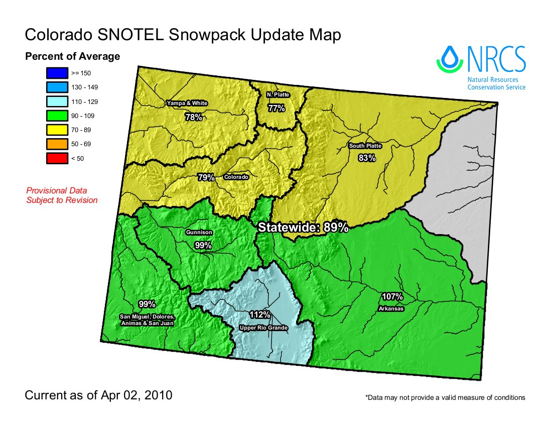
At the Dillon site, where Denver Water measures snowfall and temperatures, observers reported .66 inches of precipitation in March — less than half the long-term average (1.44 inches). Normal snowfall for March at the Dillon site is 22 inches, this year, 15 inches. The biggest single measurable snowfall was 5 inches on March 27. Temperatures recorded in Dillon were much closer to the historic norms, with the average daily high for the months at 39.6 degrees (normal, 39 degrees) and the daily average minimum temperature at 7.4 degrees (normal, 7.6 degrees)…

In Breckenridge, long-time weather watcher Rick Bly recorded 18.8 inches of snow in March compared to the historic average of 2.5 inches, or about 73 percent of average. That snow melted down to 1.58 inches of water, about 82 percent of the historic average 1.91 inches. For the weather year to-date, which started Oct. 1, 2009, precip at Bly’s weather station totals 7.62 inches of precipitation, compared to the historic average 9.1 inches. Bly has tallied 98.2 inches of snow, 78 percent of the average 127 inches for the year-to-date. But that’s still a little ahead of 2001-2002, the last major drought year, when he recorded 87 inches of snow at this point in the winter…

For our snowpack, that all translates to a 76 percent of average reading in the Blue River Basin, said water commissioner Scott Hummer. For the entire Colorado River Basin, the snowpack was 78 percent of normal as of April 2. “We’re still behind the eight-ball. “We’d need nine times the average amount of snow (in April) to hit the peak,” Hummer said.

South Platte Basin Roundable: Northern Integrated Supply Project presentation

A picture named nisppreferredalternative.jpg

From the Sterling Journal Advocate (Judy Debus):

Brian Werner of the Northern Colorado Water Conservancy District gave an update on the status and the scope of projects and processes that have been identified by the roundtables. “We’re living on people that fought for the systems and infrastructure that we benefit from today — 50, 60 and 75, 80, 90 years ago, we are living on today,” he said. “It’s been decades since we’ve done much in terms of water infrastructure in northern Colorado.”[…]

There are 33 cities and towns that get at least part of their water from the Big Thompson Project, and the need is to find out how to add to that without drying up all the agriculture land. “Even if all the proposals we have on the board were completed, there is still going to be a gap out there,” he said. At this time, most of the projects being considered will take many years to complete and there is more pressure on the ag water supplies.

More Northern Integrated Supply Project coverage here and here.

Wiggins election: Most candidates name the water supply problem as the number one issue

A picture named groundwater.jpg

From The Fort Morgan Times (Dan Barker):

Wiggins has seen its municipal water grow more mineral-laden as the water table sinks, and it has been dropping steadily for the past few years all through the local water basin. For months, the council wrangled over whether or not to have the town build its own new water system, join up with the Morgan County Quality Water District or buy water from the city of Fort Morgan. Eventually, town council members decided the least expensive method would be to build its own system and started buying water and working on designs. Now they are waiting for the U.S. Department of Agriculture to approve a grant and/or loan package to get the project started.

More Wiggins coverage here.

Flaming Gorge pipeline: Charles W. Howe — ‘Water coming out this end of the pipeline will be very expensive’

A picture named flaminggorgepipelinemillion.jpg

From The Denver Post opinion page (Charles W. Howe):

The Million project would be a costly undertaking. As proposed, it would pump 81 billion gallons of water a year (250,000 acre-feet per year, slightly less than Denver Water’s annual use) a distance of nearly 600 miles, requiring at least three new reservoirs and 16 pumping stations to lift the water uphill 3,000 feet. The Colorado Water Conservation Board estimates the project’s construction cost to be in excess of $7 billion. To cover construction and operating costs, the price of project water would have to be at least $2,200 for each acre-foot provided — which no farmer and few cities can afford.

In late 2009, the Corps of Engineers required Million to demonstrate the project’s purpose and need by providing information on interested customers. In response, Million recently produced a series of non-binding form letters from a few cities and agricultural districts in Colorado and Wyoming saying they could use extra water. Notably absent from Million’s list of interested customers are the three biggest water providers on the Front Range — Denver Water, Aurora Water, and Colorado Springs Utilities…

Perhaps the greatest cost of Million’s proposal will be borne by all Colorado water users, since Million’s project would lock up most of the state’s remaining Colorado River allocation. This removal of water from the Colorado River system would also increase the probability that Colorado will not be able to meet its obligation to the Lower Basin under the Colorado River Compact of 1922, an event that would jeopardize existing Western Slope exports to the Front Range.

More Flaming Gore pipeline coverage here and here.

2010 elections: Hickenlooper tours the west slope

A picture named superhick.jpg

From the Glenwood Springs Post Independent (John Colson):

Denver Mayor John Hickenlooper said on Friday that, if elected governor of Colorado, he would work to cut government red tape for businesses and to get warring factions of the state’s water users to work together on critical water issues…

“There must be some way to protect the heritage landscapes that make Colorado what it is, but at the same time … maybe we end up with a little bit of oil and gas in a few places where it might really mar the landscape,” he mused. “But in most cases, the oil and gas is where we’ve already got roads, we’ve already got oil production. And the question is, how to we do it and make sure that we don’t harm the ranches or the citizens around it?”

Examples of his environmental ethic, he said, include efforts to get natural gas companies to reveal all the chemical components they use in hydraulic fracturing fluids, which has been the focus of intense debate concerning possible contamination of ground water supplies in the drilling process.

Also, he pointed to what he described as a 20 percent reduction, per capita, in water consumption rates in Denver, as a way of avoiding the need to poach water from the Western Slope.

More coverage from The Grand Junction Daily Sentinel (Gary Harmon):

“What makes Denver Denver is the success of the West Slope,” Hickenlooper said at the Mesa County Democratic Assembly in the Central High School auditorium. “You would be amazed at how many people who live in Denver would really rather live in Grand Junction.”

During his tenure as mayor of Denver, he changed the culture of the Denver Water board to encourage water conservation, a development cheered by the Mesa County Democrats. “Every drop of water that can possibly be kept on the West Slope should be kept on the West Slope,” Hickenlooper said.

More 2010 Colorado elections coverage here.

Cañon City: Water rates set to decline for the first time ever

A picture named waterfromtap.jpg

From the Cañon City Daily Record (Charlotte Burrous):

“Most people will either see no change or a decrease in their water rates,” said City Administrator Steve Rabe. “Minimum water users will see an incredible drop. Overall, when we come back with a cost of service review, it showed us we needed to make a 5 percent increase in the amount of revenue that we make. We needed to do that over about three years.” “We will go from $5.4 million in 2009 to $5.7 million in 2010,” Rabe said. The bulk of the 5 percent hike will be made up with the change in the rates for Cotter and the two golf courses, based on cost of service rather than water contracts.

Customers inside city limits pay $40.68 without even using any water, he said. The rate will drop to $27.90, which is a 31.4 percent decrease.

However, customers, who use up to 80,000 gallons in a three-month period will pay $222.50 rather than $202.50 for the quarter because they are high water users.

On the non-residential side, customers using an average of 5,000 gallons per quarter will pay $9.30, compared to the current rate of $21.77, which is a decrease of 57.3 percent.

More infrastructure coverage here.

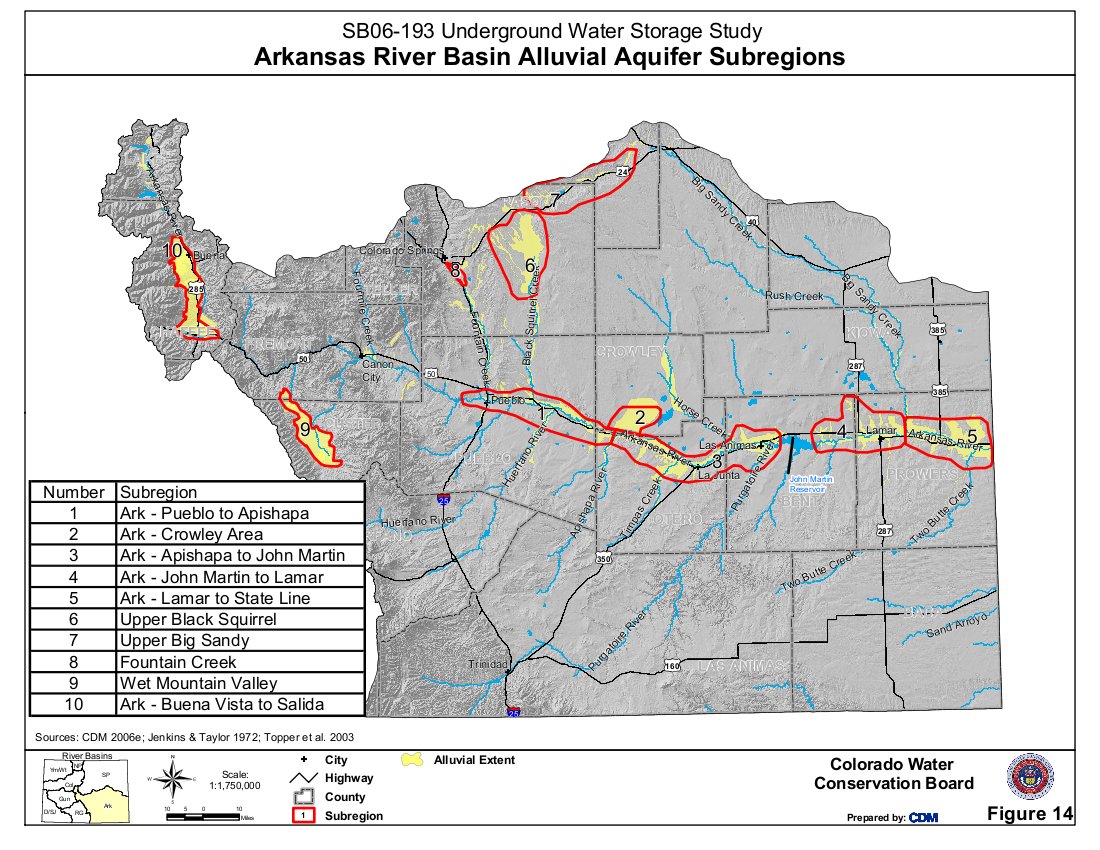
Cañon City: 2010 Arkansas Basin Water Forum — April 6 and 7

A picture named arkansasbasinalluvialaquifersubregions.jpg

From the Leadville Herald Democrat:

Along with updates on the Arkansas Basin Round Table and the various Water Conservancy Districts along the river, presentation topics will include:

• Planning for future impacts on water availability and timing in the Arkansas River basin

• Economic benefits of irrigated agriculture and water-based recreation in the Upper Arkansas basin

• Small municipal water provider panel

• Water quality issues in the Upper Basin

• Updates on Lower Basin major projects

• Announcement of the annual Bob Appel award.

Registration information and a complete program can be found at: www.arbwf.org.

More Arkansas River Basin coverage here.

Estes Park: Public invited to tour new St. Mary’s water treatment plant on April 8

A picture named watertreatment.jpg

From the Estes Park Trail Gazette (Kate Rusch):

Town Trustees and staff invite the public to an open house to celebrate the completion of this state-of-the-art facility on Thursday, April 8 from 10:00 a.m. until 2:00 p.m. A ribbon-cutting ceremony will take place at 10:00 a.m. From 10:15 a.m. until 1:45 p.m., staff will be stationed throughout the facility to explain the water treatment process…

The Marys Lake Water Treatment Plant is located at 899 Lakewood Court near the southeast side of Marys Lake. Parking is limited and carpooling is encouraged. A shuttle will be available for those who park along Lakewood Court and Marys Lake Road. The facility now uses state-of-the-art membrane technology to treat water for the residents and visitors of the Estes Valley. The new system improves filtration to exclude particles less than 1 micron in size and requires fewer chemical additives to treat water. It also prepares Estes Park to meet more stringent water treatment regulations in the future. The plant`s treatment capacity has doubled to 4 million gallons per day (MGD) in the summer and at least 2.5 MGD in the winter. The membrane filtration systems are fully automated and water plant operators will be able to focus on maintaining the system which is cleaned several times a day.

More water treatment coverage here.

Carbondale and other entities are pooling their dough to preserve Roaring Fork public fishing access

A picture named roaringfork.jpg

From the Glenwood Springs Post Independent (John Colson):

The land, approximately 7.8 acres owned by Stanley and Valerie Koziel, stretches for roughly 1,300 linear feet along the river, from the Highway 133 bridge to the north. It includes the land now occupied by a truck turnaround and a boat ramp, as well as an upper bench used for trailers and campers, known as the Sopris RV Park, according to Carbondale Recreation Director Jeff Jackel…

The town, through grants and contributions, has raised a total of $2.5 million, and will be making an offer soon, Jackel told the board of county commissioners…

The county is kicking in $100,000, and Jackel said that he has gotten $950,000 in grants from the state Division of Wildlife and $1 million from the Great Outdoors Colorado lottery fund. In addition, he said, the town of Carbondale is putting $450,000 into the deal. According to Jackel, the uses of the property will be recreational, based on a master plan he hopes to draw up with the agreement of the town’s “partners” in the purchase. He said the boat ramp ultimately is to be paved, along with a parking area, and that a riverside trail will be maintained for fishermen. Jackel also hopes to retain the camping uses, although all of it will need to be studied as the master plan is drawn up.

More conservation coverage here.

Greeley: Mandatory watering restrictions start April 15

A picture named watersprinkler.jpg

From The Greeley Tribune:

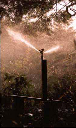
Throughout the watering season, lawn watering is not allowed between noon and 5 p.m. because it wastes water. Odd-numbered addresses are allowed to water lawns on Mondays, Wednesdays and Saturdays, while even-numbered addresses may water Sundays, Tuesdays and Thursdays. Nonresidential properties and multifamily residential properties, such as apartments and homeowner association common areas, may water lawns on Sundays, Tuesdays and Fridays. Residents who don’t comply face possible fines of up to $100 for a first violation. Outdoor use, mostly lawn watering, accounts for 55 percent of Greeley’s annual water use. The city estimates that 25 percent of the water is wasted by inefficient irrigation practices. The city offers free audits of residents’ irrigation systems, including a custom water schedule. To sign up, go to www.greeleygov.com/Water/audit.aspx and fill out the online form. For more on the city’s watering regulations, go to www.greeleygov.com/Water/news2.aspx or call (970) 336-4134.

More conservation coverage here.

Carter Lake and Horsetooth Reservoir are open to boating

A picture named carterlake.jpg

From the Loveland Reporter-Herald (Pamela Dickman):

Larimer County has hired and trained about 34 inspectors who, on days when weather won’t prevent boating, will be at the docks 6 a.m. to 10 p.m. every day. The inspectors give each boat a careful once over before it is allowed to launch to make sure no nuisance mussels are attached…

Last summer, the county started inspections on every boat going into its reservoirs. Inspectors checked 56,000 boats and found [invasive] mussels attached to three before they hit the waters at Horsetooth Reservoir. This will be the third year for inspections at Boyd Lake State Park. During that time, no invasive mussels have been found on boats.

More invasive species coverage here and here.

Colorado Foundation for Water Education’s National Ice Core Lab workshop

A picture named antarcticicecore03122010naticecorelab.jpg

Every now an then I get it right and sign up for a workshop that exceeds expectations. A while back I attended a workshop at the National Ice Core Lab. The Colorado Foundation for Water Education organized a day of speakers along with the tour of the big freezer itself.

The lab had just received a new core from Antarctica that morning and hadn’t had time to organize, classify and store it away yet. Click on the thumbnail graphic to the right for a larger view.

The Foundation posted the speaker notes yesterday. Many of the workshop participants were educators and I think it’s cool that the CFWE has made the slides available to them. Here you go (The files are in .pdf format):

A picture named drillingicecoreinantarctica.jpg

Todd Hinkley: Mapping Climate Change Impacts: How Ice Cores Reveal the Composition and Temperature of Earth’s Atmosphere

Mr. Hinkley is the former director of the lab. He explained much of the science and engineering around collecting and analyzing the cores. He also explained that the cores are examined by a wide range of researchers in many different fields.

A picture named annualclimatology1971to2000

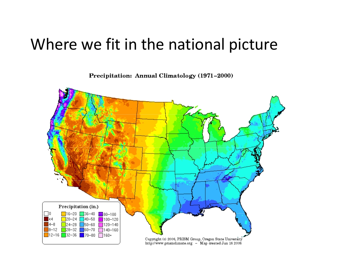
Becky Smith: Colorado’s Climate and Water Resources

Ms. Smith explained Colorado’s place in the climate picture. She showed climate data from around the state and explained the variability over the years. She demonstrated many of the online tools available from the State Climatologist’s office.

A picture named anthropogenicclimatechangelukas.jpg

Jeff Lukas (the tree ring guy): Drought, climate change, the water cycle and ecosystems: linkages and feedbacks in Colorado

Mr. Lukas explained that climate will continue to be variable but that low temperatures and high temperatures will trend upward over time.

The Foundation is planning many more of these events in the future.

More climate change coverage here.

Aspinall Unit update

A picture named crystaldamspill052009

From email from Reclamation (Dan Crabtree):

The Uncompahgre Valley Water Users will begin the irrigation season this week by starting diversion of water through the Gunnison Tunnel. Over the next three days, the Water Users will be gradually increasing diversions to 250 cfs. Releases from Crystal Reservoir will likewise increase. Flows in the Black Canyon and Gunnison Gorge will fluctuate slightly during this transition, but will end up near the present flow of about 600 cfs.

Don’t forget to put the Aspinall Operations meeting on your calendar for 1:00 p.m., April 22nd , to be held in Reclamation’s Western Colorado Area Office – Grand Junction, 2764 Compass Drive, Suite 106. We’ll be discussing spring operations and other Gunnison River basin water related activities The public is welcome.

Please contact Dan Crabtree (dcrabtree@usbr.gov) with questions or suggested agenda items.

More Aspinall Unit coverage here.

Snowpack news: El Niño weakening

A picture named snowpackcolorado04012010

Update: From the Aspen Daily News:

While the weather was still dry in Aspen around 8:30 a.m. Thursday, a “pretty miraculous” storm had moved into the Snowmass Village area, causing whiteout conditions, according to Snowmass Village police Sgt. Brian Olson. In the span of just a few hours, about a foot of new snow fell on Snowmass ski area, while Aspen Mountain saw only 5 inches, according to snow totals reported by Aspen Skiing Co. Thursday afternoon.

From the Longmont Times-Call:

[Don Graffis, a soil conservationist with the Natural Resources Conservation Service] was part of a team that trekked up Longs Peak on Tuesday to measure the snowpack. They found that with 8.8 inches of moisture, the snowpack is at 81 percent of the 30-year average. Last month, it was at 78 percent, with 6.7 inches. “Last year at this time, we were at 8.6 inches of moisture,” Graffis said. “So we are very close to what we were seeing last year on this site.”[…]

At NRCS’ measuring site near Ward, the snowpack is 100 percent of the average, with 5.7 inches of water, he said.

From NBC11News.com (James Hopkins):

The snowpack is ten percent below average, with some basins in the north central mountains at 20 percent below average. This means stream flows are also expected to be low when rafters start heading out onto the water. “Some of the upper regions will have some challenges and maybe some shorter seasons,” says [Outfitter Tom] Kleinschnitz.

The El Nino winter has pushed the bulk of the snow to the southern parts of the state, favoring the San Juans, causing the Upper Colorado basin to fall short. “As a result the southern mountains are 100% while the northern mountains are around the 70–80% range,” says Meteorologist, Mike Chamberlain. The Green River, which feeds in to the Colorado is even further behind. “The upper and lower Green river is in the 50–60% range,” says Chamberlain…

Rivers in the southern part of the state are already flowing as normal. While Grand Junction is looking to see sunshine as early as tomorrow, the higher elevations, are expecting snow straight through to next Wednesday. “The northern mountains will do a little better out of this storm,”says Chamberlain. With some areas seeing accumulations of up to two feet. Which might not bring them back to normal, but every inch helps.

From The Greeley Tribune (Bill Jackson):

Todd Boldt, along with John Fusaro, conservationists with the Fort Collins office of the U.S. Department of Agriculture’s Natural Resources Conservation Service, surveyed the April water content of the snowpack in the Poudre Canyon on Wednesday, after doing the same thing in the Big Thompson Canyon the day before. At the 10,276-foot summit at Cameron Pass, the content was 65 percent of the 30-year average and 61 percent of last year’s reading. “That’s not as bad as 2002, but it’s not good,” Fusaro said, referring to the middle of what turned out to be one of the worst droughts in history…

Even in those snowfields that showed above-average amounts, the density of the snow was considerably lower than is normally found at this time of year, which means the water content of that snowpack is not that good. That was particularly true in the Big Thompson Canyon.

Don Magnuson is the superintendent of the Cache la Poudre Irrigation and Reservoir Co., which supplies irrigation water to some 40,000 acres from near Windsor to east of Greeley and Eaton. He wasn’t happy with the latest snowpack numbers, but he emphasized the snowpack is just part of the big picture. “Reservoir storage is great, and that’s why they are there to help us through something like this. It’s yet to be seen how tight things get, and it may look real bad coming out of this in the fall. But right now, soil moisture is good, and if we don’t lose that we can get things started,” Magnuson said.

From the South Florida Sun Sentinel (Eliot Kleinberg):

At the [National Hurricane Conference] opening session Wednesday, National Hurricane Center Director Bill Read credited the quiet 2009 season to El Niño, the pattern of warm Pacific waters that tends to hinder tropical storm formation. But with the hurricane season set to start on June 1, El Niño is showing signs of weakening, which could mean more storms. Colorado State’s [Phil] Klotzbach told the conference that computer models suggest “El Niño, which is our friend and kept hurricane activity down last summer, will be gone by June or July.”

From the Fort Collins Coloradoan (Bobby Magill):

Last month was the 18th warmest and 34th wettest March in Fort Collins in Colorado State University’s 122 years of recordkeeping, according to the Colorado Climate Center’s March monthly weather summary report. The city received 1.55 inches of wet precipitation, or 109 percent of normal. Total monthly snowfall was 13.1 inches last month, or 111 percent of normal.

From the Craig Daily Press (Nicole Inglis):

National Weather Service Forecaster Aldis Strautins said a Pacific cold front stalled [Thursday] over western Colorado, focusing the moisture over Craig and surrounding areas. Strautins said the mountains in Northwest Colorado could see more than 8 inches, however, after the cold front moves through, cool temperatures will make for lighter snow, easing the burden on power lines. The forecast for Easter weekend includes two more storms to pass through the area before Tuesday, bringing more precipitation and wind to Craig.

From Steamboat Today (Brent Boyer):

A winter storm warning is in effect until 6 a.m. Friday for the mountains surrounding Steamboat. A winter weather advisory will impact the valley’s lower elevations, including the city of Steamboat Springs. Between 8 and 14 inches of snow could fall in Steamboat, with higher amounts in the northern part of the county, including Clark. The total storm accumulation could reach 8 to 16 inches at the Steamboat Ski Area. The storm will be accompanied by winds of 15 to 25 mph, and gusts as high as 40 and 50 mph, according to the National Weather Service.

Colorado legislative roundup

A picture named cottercontamination.jpg

From The Durango Herald (Joe Hanel):

The $7 billion bill to fund the state government passed the House on Thursday on a 40-25 vote. Rep. Ellen Roberts of Durango was one of three Republicans to vote for the measure. The bill now goes to the Senate…

The ninth bill in Gov. Bill Ritter’s tax package cleared the Legislature. House Bill 1197 caps the conservation easement tax credit program at $26 million a year. That’s an estimated $37 million less than the state would have given out in tax credits to preserve land from urban development. The Senate passed the bill 22-13 on Monday, and the House agreed with changes Thursday and repassed the bill on a 38-26 vote…

A bill to crack down on uranium mill pollution won strong support from the House in a voice vote Thursday. House Bill 1348, by Rep. Buffie McFadyen, D-Pueblo West, requires faster cleanup of pollution at uranium mills. The bill is targeted to Colorado’s only uranium mill, in Cañon City. A second mill could be built in Montrose County. It would not be affected by HB 1348 unless it attempted to expand without cleaning any pollution it might create.

More coverage from The Pueblo Chieftain (Patrick Malone). From the article:

The House gave preliminary approval Thursday to a bill that would hold the Cotter Corp. uranium mill near Canon City more accountable for pollution and notification of residents in polluted areas. Next, HB1348, sponsored by Rep. Buffie McFadyen, D-Pueblo West, faces a full vote of the House…

Rep. Marsha Looper, R-Colorado Springs, on Thursday said Cotter has polluted millions of gallons of groundwater. “Uranium companies need to be responsible and clean up their mess,” she said.

More 2010 Colorado legislation coverage here.

Aurora: Prairie Waters Project update

A picture named prairiewaterstreatment.jpg

From The Pueblo Chieftain (Chris Woodka):

If it weren’t for an array of metal electrical boxes and some pipes sticking up from the ground, there would be little to indicate that a state-of-the-art water system is percolating under your feet. Driving along the pipeline, which follows E-470 for about half of its 34 miles north to Aurora, you try not to blink or you’ll miss the pump station visible from the freeway. When you reach the Peter D. Binney Water Purification Facility just below Aurora Reservoir, you’re tempted to walk inside and ask for the park ranger. There’s water cascading down some steps into a clear blue pond — called a forebay. “There’s not much to see until you get into the water treatment plant,” Aurora Water director Mark Pifher apologizes…

“About 90 percent of our water is reusable in the system from all sources,” Pifher said. “Since all sources come through the treatment plant in Denver, we will use them all in the same proportion.” Aurora draws water from the South Platte, Colorado and Arkansas river basins, and reusing more of it through Prairie Waters will cut down on the amount it takes from its sources. Initially, the $659 million Prairie Waters Project will recycle up to 10,000 acre-feet — 3.25 billion gallons — each year.

“The footprint’s there so we can expand it to 50,000 acre-feet as we grow,” Pifher said. That would nearly double Aurora’s water supply from its current yield of about 58,000 acre-feet…

The first water moved through it this week, as workers and engineers tested the lines installed over the past three years. The project is more than 90 percent complete and a formal dedication is planned in September…

Aurora ratepayers will finance about 60 percent of the project, while new growth in the city is expected to pay for the rest. That’s a somewhat unusual mix for a water project, with more cost usually assigned to growth, but the drought hardening aspect of the project benefits Aurora’s current users, who have been under constant restrictions for water use since 2002. Once Prairie Waters is up and running, it will not take any additional employees to run it. The pump stations require periodic maintenance, and the automated water purification plant requires only six operators, Baker said.

More Prairie Waters coverage here and here.

The Rio Grande Headwaters Land Trust receives national accredited status

A picture named saguachecreek.jpg

From The Del Norte Prospector:

The Land Trust Accreditation Commission, an independent program of the Land Trust Alliance, announced last week that the Rio Grande Headwaters Land Trust has been awarded accredited status. “Accredited land trusts meet national quality standards for protecting important natural places and working lands forever,” said Commission Executive Director Tammara Van Ryn. “The accreditation seal lets the public know that the accredited land trust has undergone an extensive, external review of the governance and management of its organization and the systems and policies it uses to protect land.”

RiGHT Executive Director Nancy Butker said, “For the Rio Grande Headwaters Land Trust (RiGHT), accreditation provides our landowners with assurances they need in a changing and sometimes uncertain economic climate. “They can be confident that RiGHT has earned the respect and stamp of approval from our national association for our practices, our standards and the quality of conservation projects.”

More Rio Grande Basin coverage here and here.

Energy policy — nuclear: HB 10-1348 third reading tomorrow in the State House

A picture named uraniummill.jpg

From the Colorado Independent (David O. Williams):

No one spoke in opposition to HB 1348, which will have its third and final reading on the House floor Friday, and two Republicans – Reps. Marsha Looper and Tom Massey – spoke in favor of the bill, which has bipartisan sponsorship and widespread support in the Arkansas River Valley and along the southern Front Range.

More 2010 Colorado legislation coverage here.

Englewood: Raw water supply in good shape heading into summer

A picture named mclellanreservoir.jpg

From The Englewood Herald (Tom Munds):

“Right now, McLellan Reservoir is full, plus we are expecting our normal allotment of water from the Ranch Creek system this year which will more than the amount necessary to meet the needs of our customers,” Fonda said. “I don’t see a supply problem and don’t envision any type of water restrictions this summer.” Currently, the city provides treated water to about 326 million gallons of water to it customers. Almost all the 10,000 residential and commercial customers are within the Englewood city limits…

…Englewood has more water than it can treat for customer use which makes it possible to sell about 978 million gallons a year to Highlands Ranch. “The sale of water to Highlands Ranch is a plus for our city customers,” Fonda said. “The sale brings the utility department about $1.6 million a year which we put in the general fund and keeps our water rates low. We estimate our customer’s water bills would be 20 to 25 percent higher if we didn’t have the revenue from water sales.”

More infrastructure coverage here.

Eagle County, Colorado Springs and Aurora agree on Homestake plans

A picture named holycross.jpg

From The Denver Post:

Eagle County and Aurora and Colorado Springs have reached an agreement on a 15-year- old dispute over water rights in the Eagle River Basin. The agreement, announced Wednesday, prevents the two cities from obtaining water within the Holy Cross Wilderness Area. Instead, water will be diverted from the Camp Hale area, a less pristine area that was used for Army training during World War II. The agreement also calls for the two cities to build a smaller-than- planned reservoir in lower Homestake Creek and to scale back a proposed groundwater development.

More transmountain/transbasin diversions coverage here.

Flaming Gorge pipeline: What is the environmental cost?

A picture named flaminggorgepipelinemillion.jpg

From the Fort Collins Coloradoan (Bobby Magill):

Boulder hydrologist and environmentalist Dan Luecke and the pipeline’s inventor, Fort Collins entrepreneur Aaron Million, faced off in attempt to answer [environmental questions] Wednesday night at the University of Wyoming…

[Aaron] Million reiterated his view that the pipeline – a public-private partnership – would keep Front Range farms operating, provide a plethora of wind and hydropower development opportunities and prevent the fragile Green River ecosystem from being harmed. If the project proves to be environmentally unsound, he said, the pipeline should not be built.

Environmentalists are concerned the pipeline could harm endangered fish in the Green River, potentially forcing water to be diverted from pipeline users to put more water back into the river for the fish. Leucke called the pipeline “one of the most damaging kinds of water projects I can conceive of” because it would pump water above the Continental Divide from one river system to another to be consumed by growing Front Range communities…Environmentalists want the South Platte and Arkansas river systems to be managed more efficiently with an eye toward water conservation, and Million’s pipeline could encourage them to do otherwise, Leucke said.

Million countered, saying users of water from the pipeline will be mandated to comply with water conservation restrictions.

Just as serious, Leucke said, is the expense of the water from the project. He said Colorado water officials have estimated pipeline water would cost about $2,200 per acre-foot, while new water projects within Colorado could deliver water for $800 per acre-foot…

“I think the numbers we’ve been talking about didn’t look at any sort of climate variability scenarios yet,” [Former Wyoming State Engineer Jeff Fassett] said, adding that the Army Corps of Engineers will study the matter more thoroughly.

More Flaming Gorge pipeline coverage here and here.

Cañon City: Council approves new water rate structure

A picture named waterfromtap.jpg

From The Pueblo Chieftain (Tracy Harmon):

the way the city’s water rate has been structured, the more water people use the less they pay. Senior citizens with minimal water use are paying for more than they use, Rabe said. After a lengthy study of the cost to provide the water service, Rabe said that will change. Overall the water fund will see a 5 percent increase in revenue during the next three years. “There will be a big difference for minimal water users,” Rabe said. For example, residential customers who use less than 10,000 gallons of water in a three-month period will see the rate change from $40.68 to $27.90. That is a 31 percent decrease, Rabe said. Nonresidential customers who use less than 5,000 gallons in a three-month period will see the rate drop from $21.77 to $9.30, or a 57 percent decrease, Rabe said…

“People who use the average 30,000 gallons in a quarter will see no change or a slight decrease. People who live in areas where we have to pump the water uphill, like Dawson Ranch or North Fifth Street, will see an increase in the zone surcharge. It will go up a little bit,” Rabe said. City Finance Director Harry Patel said the majority — about 60 percent — of the city’s water customers are using less than the 30,000 gallon average. Water users will not see an increase in stormwater fees, nor will the $5,000 new tap fees go up.

More infrastructure coverage here.

Arkansas River Watershed Tamarisk Workshop recap

A picture named goatmunchingtamarisk.jpg

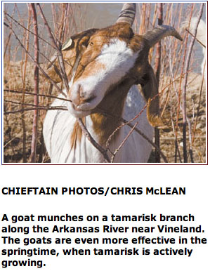
From The Pueblo Chieftain (Chris Woodka):

The workshop attracted 86 participants from all parts of the valley as part of the Arkansas River Invasive Plants Plan, an effort launched in 2007 by the Southeastern district and 30 partners to aid in restoring land taken over by tamarisk…

While the strategies vary in different parts of the basin, the basic lessons are the same:
Most have stopped talking about eradication and are looking at knocking back infested areas to the point where natural vegetation will have a change.
– Many partners are needed in projects, as well as the cooperation of landowners. Not all landowners want to remove tamarisk and may even value their presence as windbreaks.
– One swipe at the problem may get rid of 90 percent of the invasive trees, but follow-up efforts are needed. Complete restoration can depend on how well native vegetation takes hold.M.

“Complete eradication is pretty much impossible,” said Mike Eichenberry of the U.S. Forest Service, which has been eliminating between 500-800 acres of tamarisk each year since 2004 on the Comanche grasslands…

In North La Junta, a flood control district is using a different method for a different purpose, said Mike Taylor of the Natural Resources Conservation Service. Tamarisk and willows have constricted the channel of the Arkansas River and reduced its ability to protect North La Junta from floods. The river has filled with about 15 feet of sediment since the 1965 flood, and the goal is to widen the channel to 300 feet. That should accommodate a 25- to 50-foot flood and avoid a repeat of flooding in 1999. The district, NRCS and other partners are using a root rake — large teeth attached to the blade of a bulldozer — to dig out tamarisks to a depth of two feet. “Once you get at them deep enough, they will not regenerate,” Taylor said. The willows are tougher, and like tamarisk hold soil in banks against erosion. Taylor laughed that it was the first time in his career that he’d been involved with a project trying to encourage erosion, saying a small flood would help scour the river. And while the area at first looks like a “moonscape,” native plants come back, and local residents are enjoying the effect. “Each spring we’re seeing people picnicking and enjoying the river. They say they haven’t seen the river in years,” Taylor said…

Killing tamarisk by any means will take years, but they most likely won’t come back as strong, said Anna Sher, a revegetation expert from the University of Denver and Denver Botanical Gardens. “Managing for native species will result in less tamarisk cover,” Sher said.

More tamarisk control coverage here and here.