NISP: ‘…from 2009 to 2011, more than 1 million acre-feet of water left the state’ — Hank Brown

nisppreferredalternative.jpg

Here’s a guest column arguing the necessity of the Northern Integrated Supply Project (NISP) to keep Front Range cities from drying up more irrigated agricultural land, written by Hank Brown, running in The Denver Post. Here’s an excerpt:

Taking water used by agriculture for new homes involves drying up thousands of acres of our most productive irrigated farms. The result will be higher temperatures in the summer, more carbon dioxide in our atmosphere, and the loss of food and fiber production in Colorado.

What is the answer? The Northern Integrated Supply Project (NISP) is being proposed by northern Colorado cities and water districts to save for Colorado thousands of acre-feet of water that is now being lost to Nebraska. The water belongs to Colorado under the federally recognized interstate compact, yet from 2009 to 2011, more than 1 million acre-feet of water left the state — water the state had rights to use.

What will the project do for our environment? It will improve minimum stream flow, protect against flood and drought, and help prevent the drying up of our farm land. Without NISP, environmental studies estimate that an additional 100 square miles of northern Colorado farmland will be dried up.

More Northern Integrated Supply Project coverage here and here.

Green Mountain Reservoir operations update: 330 cfs in the Blue River below the dam

greenmountainreservoir.jpg

From email from Reclamation (Kara Lamb):

We have another change at Green Mountain Dam. As has been typical the last six or so weeks, we are seeing operational changes at the dam about every three to four days.

In collaboration with other reservoir operators, we continue to follow Mother Nature’s storms, adjusting releases as we go. Recent rains have boosted flows in the Colorado River slightly, so we have been asked to cut back our releases from the dam to the Lower Blue.

Around 11 a.m. today, August 13, we cut back by 50 cfs, to about 330 cfs. The Lower Blue River should now be running at about 330 cfs.

More Colorado-Big Thompson Project coverage here.

Ruedi Reservoir operations update: 213 cfs in the Fryingpan River below the dam

fryingpan.jpg

From email from Reclamation (Kara Lamb):

We’ve seen inflows to Ruedi decrease over the weekend as the afternoon storms have slowed. As a result, we have less water to pass on down to the Colorado River. Today around 5 p.m. we will scale releases from Ruedi Dam to the Fryingpan back by about 28 cfs. This will put flows past the Ruedi Dam gage at about 213 cfs.

More Fryingpan-Arkansas Project coverage here.

CWCB: Statewide Drought Conference September 19-20

usdroughtmonitor08072012.jpg

From email from the Colorado Water Conservation Board (Ben Wade):

The CWCB State Drought Conference: Building a Drought Resilient Economy through Innovation is 5 weeks away! We are pleased to announce that John Paul DeJoria, Global Businessman and Philanthropist & Steve Maxwell, author of “The Future of Water” will be our keynote speakers; and Governor John Hickenlooper will be speaking at the Conference as well.

Here’s the link to the registration page.

More CWCB coverage here and here.

Colorado Water 2012: 100th anniversary celebration of Rio Grande Reservoir August 23

riograndereservoir.jpg

Here’s the latest installment in the Valley Courier’s Colorado Water 2012 series. Travis Smith writes about the recent 100th anniversary celebration for Rio Grande Reservoir. Here’s an excerpt:

This 100th anniversary is a time to capture for a few moments, the vision of people like Frank Sylvester, David Miles, S.J. Schoonover and Charles Speiser who, in October of 1908, formed the San Luis Valley Irrigation District under authority of the newly created Irrigation District Statute of 1905 from the former Farmers Union Irrigation Company.

The Farmers Union Irrigation Company was formed in the late 1880’s as a mutual ditch company to provide irrigation water to the lands near Center, and extending eastward to Hooper. The Farmers Union Canal is a junior canal, and its priorities did not provide for a reliable water supply. Frank Sylvester and the Farmers Union Board recognized in the early 1890’s the need for a reservoir to provide a more reliable water supply.

Discussions of building Rio Grande Reservoir began in 1892, with a preliminary survey during 1905 -1907; plans of site purchases, reservoir design, and how to finance such a large and bold undertaking. The board of the newly formed San Luis Valley Irrigation District, in 1908, moved quickly to secure funding for the actual construction of the reservoir at the headwaters of the Rio Grande by issuing bonds worth $530,000. The reservoir site was purchased from a Creede entrepreneur named A.V. Tabor.

Engineering work including test pits and surveying began in 1907. The tunnel was drilled and completed by 1910 and the outlet was installed soon after. In June of 1912 the reservoir stored and released water to be used beneficially on District lands while the dam was being completed to establish a storage right.

The 100th anniversary celebrates the successful effort and continued operation of the reservoir by the people of the San Luis Valley Irrigation District, and the dedication of the board of directors, who are landowners elected by the members of the District. 100 Years of Rio Grande Reservoir, guided by the board of directors, is a story of determination and commitment…

There are names which are not often mentioned today, but were very instrumental in the building of Rio Grande Reservoir. The Honorable Charles Holbrook, General Bloomfield, F.C. Goudy and San Luis Valley Irrigation District Attorney Charles Corlett made many trips to Washington D.C. on behalf of the citizens of the San Luis Valley to persuade the federal government to rescind the prohibition on storage projects on the upper Rio Grande. The Chief Engineer J.C. Ulrich from Denver designed and supervised the construction of the reservoir, which took three years and involved 50 to 100 teams working in very harsh conditions…

Rio Grande Reservoir is now preparing for the future by honoring those who made the first 100 years possible. The San Luis Valley Irrigation District is pleased to celebrate Rio Grande Reservoir’s 100th Anniversary on August 23, 2012 at the reservoir.

More Colorado Water 2012 coverage here.

Western Slope interests are, ‘better off at the table than on the menu’ — Bill Trampe

Here’s a profile of Rancher and water wonk, Bill Trampe, written by Jennifer Bock running in the Grand Junction Free Press. From the article:

Although water is probably more essential to his livelihood than many of us in the Gunnison Basin, Trampe admits that his philosophy on keeping water in the Gunnison Basin has changed over the years.

When Arapahoe County proposed the Union Park project, Trampe recalls that the local sentiment was “not one drop” and no one dared stray from that strict line in the sand.

Today, Trampe thinks that Western Slope interests are “better off at the table than on the menu” when it comes to talking to the Front Range and others about West Slope water. Trampe’s philosophy is tied to real life experience: He has spent the last seven years negotiating with the Front Range to develop the Colorado River Water Cooperative Agreement.

Perhaps characteristic of a rancher’s outlook, Trampe is both hopeful and frustrated when it comes to resolving Colorado’s water disputes.

He believes, as many do, that big, transmountain water projects simply won’t be able to provide enough firm yield to satisfy Front Range interests. In statewide water planning discussions, Trampe has been a proponent of addressing this problem through risk management — the idea that the state must have a comprehensive way to evaluate and guard against the potential consequences of failing to meet water delivery obligations to downstream states as it considers new diversions out of the Colorado River Basin.

More Gunnison River Basin coverage here and here.

Colorado River Basin: ‘…last year’s bounty appears to have been little more than an apparition’ — Pat Mulroy

blueriver.jpg

From the Las Vegas Sun (Pat Mulroy):

After last year’s strong snowpack in the Rocky Mountains brought much-needed relief to a rapidly declining Lake Mead, there was optimism that perhaps the devastating drought that has plagued the Colorado River for the past decade was drawing to a close. Unfortunately, this year’s record dry conditions — which have extended throughout much of the continental United States — have dashed those hopes. Just as we have seen through many periods of extended drought along the Colorado River, last year’s bounty appears to have been little more than an apparition, disappearing more quickly than snow on the majestic mountain peaks of Colorado and Wyoming.

If climate scientists are correct, the West has many more such periods ahead. This new reality will fundamentally change the way we manage this crucial resource. This challenge will require a more selfless and fully engaged level of collaboration among communities and states than ever before.

More Colorado River Basin coverage here here.

Drought news: Low streamflow and high water temperatures are tough on aquatic species

blueriver.jpg

From the Summit Daily News (Brian Lorch and Lane Wyatt):

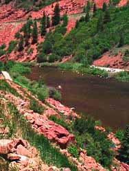
Managing our demand for water by implementing water conservation measures also reduces the stress on the aquatic environment found in the streams and reservoirs that are the source of most of our local water supplies. As the stream flows diminish in a drought, water temperature goes up and habitat and refuge for fish and aquatic invertebrates goes down…

In Colorado, only the Colorado Water Conservation Board (CWCB) can hold water rights to protect streamflows for the environment. Individuals, environmental groups and others cannot hold these water rights for instream environmental purposes although they can petition the CWCB to acquire these rights or can donate existing water rights for this purpose. The CWCB will consult with the Division of Parks and Wildlife to quantify an instream flow level that provides only the “minimum amount to protect the environment to a reasonable degree”. This flow is usually enough to provide passage for fish though riffles that may limit connectivity to pools and other safe havens, essentially only about enough to keep the backs of the fish wet in these shallow areas.

Like other water rights in Colorado, the effectiveness of these instream flow water rights to protect stream- flows is based on their seniority within the prior appropriation system. So in order for the instream flow rights to protect streamflows from diversions out of the stream they must be senior, or older than the water right associated with the diversion. We are lucky in Summit County that most of our streams have some instream flow water right for protection. For a description of the instream flow water rights in Summit County and for more information on Colorado’s instream flow program, check out this website: http://cwcb.state.co.us /environment/instream-flow-program/Pages/main.aspx

From NOAA’s State of the Climate webpage:

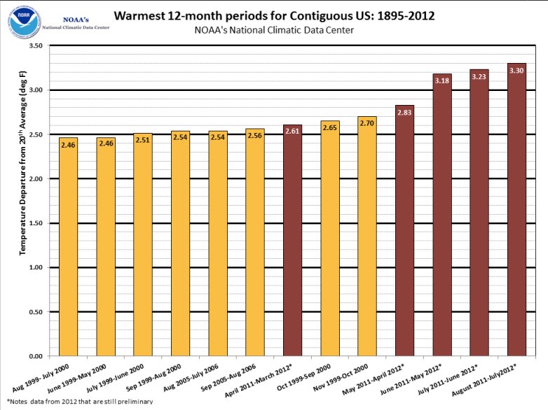
The May-July months, an important period for agriculture, was the second warmest and 12th driest such three-months for the Lower 48, contributing to rapid expansion of drought. The central regions of the country were hardest hit by the drought, where ten states had three-month precipitation totals among their ten driest, including Nebraska, Kansas, and Arkansas which were record dry.

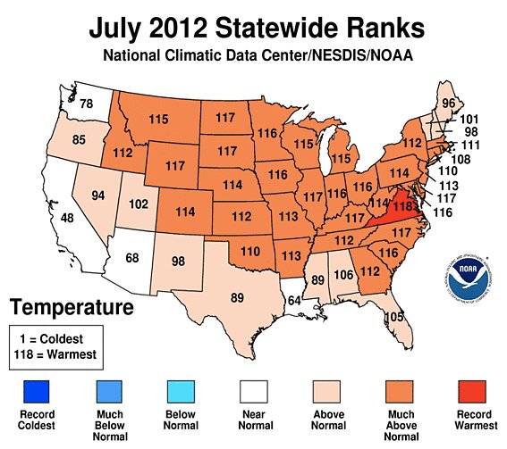
According to the July 31, 2012, U.S. Drought Monitor (USDM), 62.9 percent of the contiguous U.S. was experiencing moderate to exceptional drought at the end of July. This is an increase of about 6.9 percent compared to the end of June. The maximum value of 63.9 percent reached on July 24 is a record in the 13-year history of the USDM.

The area of the country in the worst drought categories (extreme to exceptional drought) doubled from 10 percent last month to 22 percent this month. The extreme dryness and excessive heat devastated crops and livestock from the Great Plains to Midwest.

The Primary Corn and Soybean Agricultural Belt, hard hit by drought, experienced its eighth driest July, third driest June-July, and sixth driest April-July (growing season) in the 1895-2012 record.

According to the Palmer Drought Severity Index, whose record spans the 20th century, about 57 percent of the contiguous U.S. was experiencing moderate-to-extreme drought in July. The last drought this extensive was in December 1956 when about 58 percent of the nation was in moderate-to-extreme drought.

From the Summit Daily News (Paige Blankenbuehler):

In total, $1,865,850 has been made available to Colorado farmers and ranchers through the Natural Resources Conservation Service and the U.S. Department of Agriculture. “Colorado farmers and ranchers are experiencing the most devastating drought in decades,” [U.S. Senator Michael Bennet] said. “At a time when our economy is just getting back on its feet, we need all hands on deck to ensure that our rural communities have the tools they need to continue to grow and thrive. I encourage producers across Colorado to take advantage of the resources.”

Bennet’s comments come in a timely way as corn prices hit a record high Friday as the U.S. government slashed its forecast for the drought-damaged corn crop even more than analysts were expecting.

From email from Colorado Parks and Wildlife (Jennifer Churchill):

Drought conditions and low water flows throughout the state have Colorado Parks and Wildlife reminding anglers to monitor water temperature when they are out fishing. Several water-specific recommendations have already been released this summer; however aquatic biologists recognize that fish can be stressed due to temperatures in many different coldwater fishing locations.

“Handling fish in waters that are 68 degrees and above can put undue stress on them, causing mortalities and compromising the fishery as a whole,” said Ken Kehmeier, senior aquatic biologist for the Northeast region. “We ask that anglers keep in mind the production opportunity of a fishery and not solely the fishing opportunity. Get out and fish, but bring along a thermometer and try to fish early in the day for the best opportunities.”

Here’s a release from the USDA:

As part of the Obama Administration’s commitment to do everything it can to help farmers, ranchers, small businesses, and communities being impacted by the nation’s persistent drought, Agriculture Secretary Tom Vilsack today announced USDA’s intent to purchase up to $170 million of pork, lamb, chicken, and catfish for federal food nutrition assistance programs, including food banks. The purchase will help relieve pressure on American livestock producers during the drought, while helping to bring the nation’s meat supply in line with demand while providing high quality, nutritious food to recipients of USDA’s nutrition programs.

“President Obama and I will continue to take swift action to get help to America’s farmers and ranchers through this difficult time,” said Vilsack. “These purchases will assist pork, catfish, chicken and lamb producers who are currently struggling due to challenging market conditions and the high cost of feed resulting from the widespread drought. The purchases will help mitigate further downward prices, stabilize market conditions, and provide high quality, nutritious food to recipients of USDA’s nutrition programs.”

Today, USDA announced its intention to purchase up to $100 million of pork products, up to $10 million of catfish products, up to $50 million in chicken products, and up to $10 million of lamb products for federal food nutrition assistance programs, including food banks. Through the Emergency Surplus Removal Program, USDA can use Section 32 funds to purchase meat and poultry products to assist farmers and ranchers who have been affected by natural disasters. The pork, lamb and catfish purchases are based on analyses of current market conditions. A major factor affecting livestock producers is the value of feed, which is currently running high because of the drought.

USDA’s Agricultural Marketing Service (AMS) purchases a variety of high-quality food products each year to support the National School Lunch Program, the School Breakfast Program, the Summer Food Service Program, the Food Distribution Program on Indian Reservations, the Commodity Supplemental Food Program and the Emergency Food Assistance Program. USDA also makes emergency food purchases for distribution to victims of natural disasters. Government food experts work to ensure that all purchased food is healthful and nutritious. Food items are required to be low in fat, sugar and sodium. The commodities must meet specified requirements and be certified to ensure quality. AMS purchases only products of 100 percent domestic origin.

Last week in Washington, President Obama convened his White House Rural Council to review Executive Branch response actions and to develop additional policy initiatives to assist drought-stricken Americans. Following the meeting, the White House announced a number of new measures the Administration is taking, including USDA’s assistance for livestock and crop producers, the National Credit Union Administration’s increased capacity for lending to customers including farmers, and the U.S. Department of Transportation’s emergency waivers for federal truck weight regulations and hours of service requirements to drought-stricken communities. President Obama also stressed the need for the entire Administration to continue to look at further steps it can take to ease the pain of this historic drought.

From Steamboat Today (Tom Ross):

Commercial tubers are required to shut down when the river is below 85 cubic feet per second, and that’s where the town stretch of the Yampa has been during the day since Monday.

The river was flowing at 80 cfs past the U.S. Geological Survey gauge at the Fifth Street bridge at 6:30 Friday morning, and with vacationing families shifting into back-to-school mode, the tubing season is fast dwindling.

The median flow for this date is 165 cfs, but Van De Carr had a positive take on the way the summer has unfolded, calling conservation releases from Stagecoach Reservoir and voluntary releases from Lake Catamount a godsend.

Earlier this summer, the Colorado Water Trust made use of a new state law that allows for temporary leases of stored water rights and consummated a deal with the Upper Yampa Water Conservancy District to gradually release 4,000 acre feet of water into the river so that a portion of it could reach the town section and beyond. The releases are scheduled to last into September.

The Lake Catamount homeowners association responded in early July by releasing an additional amount that made the river more attractive for tubing.

The Yampa below Stagecoach was flowing at 68 cfs Friday morning, and gauges maintained by the Colorado Division of Water Resources showed that 69.5 cfs was flowing out of the outlet at the Lake Catamount dam and another 13 cfs was coming from the spillway.

Colorado Water 2012: ‘Water truly is the lifeblood of a community’ — Jean Van Pelt

coloradowater2012.jpg

Here’s the latest installment in The Pueblo Chieftain’s series for Colorado Water 2012. Jean Van Pelt describes the Fryingpan-Arkansas Project. Here’s an excerpt:

…the Fryingpan-Arkansas Project has provided Southeastern Colorado with 50 golden years of benefits. The Fryingpan-Arkansas Project is a transmountain diversion that supplies Southeastern Colorado with supplemental water for irrigation, municipal and industrial uses, hydroelectric power, and recreational opportunities. The project also provides flood control and is designed to maintain or improve fish and wildlife habitats. The project acquired its name from the fact that it collects about 54,800 acre-feet of water each year from the Fryingpan River basin on the Western Slope of the Continental Divide and delivers it via the Arkansas River to the water-short Eastern Slope…

The North and South Side Collection System and Ruedi Dam and Reservoir are located on the Western Slope in the Fryingpan River basin. Sugar Loaf Dam and Turquoise Lake; Mount Elbert Conduit, Forebay Dam, Reservoir and Power Plant; Halfmoon Diversion Dam; Twin Lakes Dam and Reservoir; and Pueblo Dam and Reservoir are all located on the Eastern Slope in the Arkansas River basin.

More Colorado Water 2012 coverage here.

Restoration: Woods Lake fish are going to get a dose of Rotenone to pave the way for expanded cutthroat habitat

woodslakecdow.jpg

From The Telluride Daily Planet (Collin McRann):

Over the past year, the lake and its tributaries — located off of Forest Service Road 618 west of Telluride — have been the subject of a Colorado Parks and Wildlife project to eliminate non-native trout, mainly brookies and browns, to make way for native cutthroats. Though the project was supposed to be complete by this summer, an assessment revealed brooke trout are still living the lake.

“Last year we treated the lake and tributaries and then they went back this summer, and we found mainly young of the year — brooke trout,” said John Alves, a Senior aquatic biologist with Colorado Parks and Wildlife. “It looks like some of them might have spawned before we got the project going last year, so there’s some that we have to go hit again this year, that’s going to happen next week.” The lake will be treated Aug. 14-16 with a chemical called Rotenone. Alves said the treatment will focus on areas of the lake where the brooke trout were found.

Another assessment will be done after the treatment via electro fishing and gill netting. If it is then determined the lake is ready for a transplant of cutthroat, the fish could be transported into the area as soon as this fall. If not, the lake will be left barren until next year…

The transplant will involve at least 2,000 cutthroats a year, which will be taken from different brood stocks and hatcheries around the state. Though no specific source for the fish has been determined, Alves said Kelso Creek in the Uncompahgre National Forest is a likely candidate.

More restoration/reclamation coverage here and here.

Drought news: $100 million impact from 2011 drought in the Arkansas Valley, 2012 could be worse #CODrought

usdroughtmonitor08072012.jpg

From The Pueblo Chieftain (Chris Woodka):

The 2011 drought cost the Arkansas Valley more than $100 million and 1,300 jobs, an analysis by Colorado State University-Fort Collins shows.

The bad news is that 2012 could be worse.

“This year will be worse because drought is more widespread over the state, and because irrigated agriculture is affected as well as dryland crops,” said James Pritchett, an economics professor who help prepare the study.

Pritchett presented the findings Wednesday to the Arkansas Basin Roundtable, which looks at water issues and networks with other basins in the state. The study was completed last year, and looks at traditional economic concerns such as lost potential for growing crops and the impact on supplies.

From USA Today (Richard Wolf):

The president used his weekly radio address to cite the record heat — July was the warmest month on record — as one reason why Congress must compromise on farm legislation.

“Today, I want to talk about something that most of you know already — it’s hot outside,” Obama said. “It’s really hot.”

While his administration has taken several steps to help farmers get emergency loans, open up more federal land for grazing, and get water to livestock and supplies to small businesses, Obama said Congress hasn’t done its part.

“So call your members of Congress, write them an e-mail, and tell them that now is the time to come together and get this done,” he said. “Too many Americans are suffering right now to let politics get in the way.”

From The Huffington Post (Wm. Robert Irvin):

While this year’s drought may be the worst in 50 years, indicators suggest that this may be a harbinger of things to come, with more frequent and extreme droughts of this magnitude in the future. While drought in any particular year may not be attributable to global climate change resulting from human activities, it is now abundantly clear that climate change makes drought and other extreme weather events more likely.

The U.S. Global Change Research Program found that droughts — such as the one we are experiencing now — are likely to become more common and intense as precipitation patterns change. We can expect longer and warmer dry spells between rain events that will dry out soils and intensify drought conditions. In 2011, the Intergovernmental Panel on Climate Change (IPCC) released a report on managing extreme events and disasters, which predicted that in the U.S. the most noticeable changes we will see are in the number and intensity of extreme drought events.

We all need clean water. The prospect of more frequent and extreme droughts across the U.S. challenges us to find new ways to secure reliable clean water supplies for today and the future. While we cannot make it rain, we can manage the water we have in ways that make our communities and rivers more resilient in the face of extreme and frequent droughts that accompany climate change.

From the Gannett Washington Bureau (Raju Chebium) via the Fort Collins Coloradoan:

Drought conditions affecting more than half the country are expected to cost farmers about $12 billion nationwide, according to preliminary estimates…

After oil and gas, agriculture is the second-largest industry in Colorado, generating about $4 billion a year, said Shawn Martini, spokesman for the Colorado Farm Bureau. About two-thirds of Colorado’s 200,000 farms belong to cattle, sheep and horse owners, he said. So an ailing agriculture industry will have ripple effects on the state’s entire economy.

The biggest problems livestock owners face are scarce grazing grounds and escalating prices for hay and grain, experts say…

Last month, the Obama administration decided to allow grazing and haying on some of the 29.6 million acres in the Conservation Reserve Program, which pays landowners to leave environmentally sensitive land untouched for at least 10 years…

[Jon Slutsky, owner of La Luna Dairy in Wellington] has seen feed prices climb from $130 a ton in early 2011 to $230 a ton this summer. “That’s a bargain,” he said. “There are guys who are paying $300 a ton. There are people talking about prices going to $400 a ton.”

A hint of fall in the air this morning

ACSL = Altocumulus Standing Lenticular (clouds).

Initiatives 3 and 45: ‘We now know that the process is adversarial’ — Richard Hamilton

justianifirstdodifierofriparianrights.jpg

From The Colorado Statesman (Peter Marcus):

Two efforts to protect water sources in Colorado also failed after sponsors were unable to submit signatures on Monday. Both initiatives aimed to declare water as belonging to the people of Colorado.

Initiative 3 would have simply declared that the public owns the water of Colorado; Initiative 45 would have addressed use and environmental issues by allowing the public to “limit” or “curtail” the right to divert water within the state.

Richard Hamilton, who sponsored both initiatives, said they were hampered by a challenge to the title language, which went to the Colorado Supreme Court and was not settled until April 16, dramatically shrinking the period of time sponsors had to collect signatures.

In the end, sponsors ended up with about 30,000 signatures, said Hamilton.

“We’ll go back and put something in and go after them again in 2014,” he said. “Hopefully there will not be such inordinate delays. We now know that the process is adversarial.”

Critics, including the Colorado Water Congress, the Colorado Water Conservation Board, and the Colorado River Water District, had opposed the measures, stating that the initiatives were too broad, allowing the public to block water diversions for a wide range of issues that could affect how the state and local governments distributed needed water.

More 2012 Colorado November election coverage here.

Drought news: USDA predicts corn crop crash, while prices soar

usdroughtmonitor07312012.jpg

From CNN (Aaron Smith):

In its monthly World Agricultural Supply and Demand report, the USDA projected the corn harvest would plunge by 2.2 billion bushels, or by 22.6 bushels per acre, resulting in a harvest of 123.4 acres per acre. That’s worse than expected and puts the 2012-2013 yield on track to be the lowest since the 1995-1996 harvest…

Meanwhile, the USDA also said it now expects farm prices for corn to hit a record high this season of $7.50 to $8.90 per bushel, sharply higher than its July forecast of $5.40 to $6.40 per bushel. The USDA blamed “extreme and dryness” in the Central Plains and the Corn Belt…

Fewer crops has translated into higher prices for consumers. On Thursday, the United Nations released a report that showed world food prices jumped 6% in July.
Corn was the biggest culprit for the price hike. The global price of corn surged nearly 23% last month…

The drought is also taking a toll on soybeans, which are essential to oil products such as cooking oil, margarine and peanut butter. The USDA dropped its yield forecast to 36.1 bushels per acre. That’s 4.4 bushels lower than last month’s estimate, and 5.4 bushels below last year’s yield. The USDA said that soybean prices surged to record levels, up $2 to a range of $15 to $17 per bushel.

I think the U.S. Drought Monitor computer was so depressed it committed suicide today. I’m lucky I had the drought map from last week, I can’t get the latest one this afternoon.

South Platte River Basin: New stream flow and river call map from United Water and Sanitation

southplatterivercallsunitedwaterandsanitation.jpg

Update: It was early this morning when I first posted this and I neglected to point out that they have mapped selected stream gages as well.

Sometimes it’s nice to look at the calls on the river graphically. Thanks to the United Water and Sanitation District you don’t have to haul out your straight line diagram for the South Platte Basin. They’ve built an online map with current river calls.

Click on the thumbnail graphic for a screen shot of this morning’s map.

Here’s the release from United Water and Sanitation:

United Water and Sanitation District has unveiled a first-of-its-kind South Platte River Basin map that allows water users and providers throughout the Front Range to get real-time, visual information about the status of the South Platte River and its tributaries.

The map (http://map.unitedwaterdistrict.com/”>) aggregates hourly data from a variety of sources, including the United States Geological Survey (USGS) and the Colorado Division of Water Resources, providing comprehensive streamflow information from the South Platte River Basin. Map users can scroll over dozens of river locations to get valuable and timely information, including:

– River height (ft)
– Streamflow rates in cubic feet per second(cfs)
– Active calls on the river
– Apparent dry-up points

“This map allows users to see the supply side along with the demand side of the river basin as conditions change,” said Josh Shipman, asset manager for United Water and Sanitation District. “We have taken a tremendous amount of data and put it in a visual, interactive format, making it easier for water users and providers to quickly and easily get information. It now only takes a few seconds to get information on the river that previously took hours to compile and compare.”

With numerous water rights and supply interests along the South Platte River basin, United Water anticipates a variety of interest in the map – from ditch companies and water districts to farmers and municipalities – particularly in a dry year like one we are currently experiencing.

“Ultimately this map allows any interested party to monitor real time, stream conditions to ensure they are receiving the full allocation of their call on the river,” said Ron von Lembke, chief of staff at United Water and Sanitation District. “But it can also be useful for water recreationalists such as kayakers and fishermen who are interested in water conditions related to their activities.”

The map encompasses all of the South Platte River basin – including each of the 16 Districts included in Water Division 1 of the Colorado Division of Water Resources(http://water.state.co.us/DWRIPub/DWR Maps/ColoradoRiverBasins.pdf) While there is potential to expand the map to other divisions throughout the state, United Water’s immediate focus will be on adding streamflow monitoring stations and select weather stations in these districts to further enhance its current functionality.

More South Platte River Basin coverage here and here.

Ruedi Reservoir operations update: 244 cfs in the Fryingpan River at the Ruedi gage

ruedidam.jpg

From email from Reclamation (Kara Lamb):

Despite some guesstimates I made over the phone and e-mail the past few days, the slight bump up we’ll see later today has more to do with the senior water right call down at Cameo on the Colorado River than anything else.

Around 5 p.m. today, August 9, we’ll bump releases from Ruedi Dam to the Fryingpan River up by about 20 cfs to a flow of around 244 cfs at the Ruedi gage.

We have not seen the Cameo senior water right call really affect Ruedi Reservoir for about 15 years. In more typical water years, reservoirs further upstream on the Colorado keep the call off of Ruedi. With the extreme conditions this year, however, we are seeing this water right call have effect. Recent afternoon rainstorms have generated a little bit of run-off into Ruedi Reservoir and we are adjusting our releases to pass that inflow on downstream.

Still, the draw at Ruedi is not as steep as other reservoirs are currently experiencing. Today, it is at a water level elevation of about 7745 feet, or roughly 81% full.

Green Mountain Reservoir operations update: 380 cfs in the Blue River below the dam

greenmountainreservoir.jpg

From email from Reclamation (Kara Lamb):

After the weekly coordination call today, we have made another change at Green Mountain Dam. We have dropped releases down to about 380 cfs in the Lower Blue River. Green Mountain Reservoir is currently at a water level elevation of about 7915 feet, or roughly 60% full. Considering the reservoir only got to an elevation of 7928 feet this year, that means it has dropped about 13 vertical feet since late June.

Durango: San Juan Citizens Alliance Annual Membership Meeting August 22

durango.jpg

From email from the San Juan Citizens Alliance:

SJCA Annual Membership Meeting

August 22
6:00-8:00 p.m.
Durango Public Library
1900 E. 3rd, Ave., Durango

Join us for dinner, board member nominations, and updates on our accomplishments over the past year.

Please bring a dish to share, beverages will be provided.

More San Juan Basin coverage here and here.

Cloud seeding: Applied science or alchemy?

cloudseedingexplained.jpg

From the High Country News’ Goat blog (Emily Guerin):

Making rain may seem a bit like alchemy, but the practice has been around since the 1940s, when engineers at General Electric began experimenting with dumping dry ice into clouds from airplanes. Water districts and ski resorts around the West got into the practice in the 1970s, shooting silver iodide into winter clouds from mountain-top cannons…

Silver iodide crystals behave like ice, attracting water droplets to them until they grow big enough to fall to the ground as snow. Cloud seeding advocates say the practice is inexpensive—$10-20 per acre-foot of water created—and can boost snowfall by 10 to 15 percent. They’re also quick to point out there are no documented negative environmental effects of the process.

But it’s hard to separate cloud seeding-induced precipitation from what falls naturally from the sky. A 2010 study by Israeli researchers examining rainfall patterns and cloud seeding over the Sea of Galilee in Northern Israel found that a series of cyclones were responsible for increased rainfall over a six-year period, not cloud seeding. The state of Wyoming is currently spending $11 million on a multi-year study to determine whether the practice works and is cost-effective. Results are expected in 2014.

Still, the science is apparently convincing enough for water districts in Southern California, Nevada and Arizona to pay Upper Colorado River Basin states to seed clouds. Since 2006, Lower Basin states have spent over $800,000 in Colorado and around $500,000 in Utah and Wyoming.

More cloud seeding coverage here and here.

Telluride: Engineering report rates the town’s water system as ‘poor’ and the sewer system as ‘fair’

bridalveilfallstelluride.jpg

From the Telluride Daily Planet (Katie Klingsporn):

Engineers from Farnsworth Group presented a review of Telluride’s water and sewer systems to the Telluride Town Council on Tuesday. In their assessment, Engineers Xuehua Bai and Eric Garner reviewed the health of miles of the town’s pipeline based on factors like age and material of the pipe, assigned scores to segments of the system and gave overall ratings. Based on their data, they concluded that the overall rating of the town’s municipal water system is poor, while the sewer system fared better with a rating of fair.

The town’s municipal water system is fed by Mill Creek, and includes the treatment plant at Mill Creek, a backup source at Stillwell Tunnel, three storage tanks and 19.6 miles of pipeline…

The Farnsworth Group concluded that the town needs to replace 14,000 feet of its water pipelines, or 13.6 percent of the total water line. The cost is estimated to be about $1.6 million, although that estimate is based on 2011 prices.

In the sewer system, meanwhile, the engineers identified 5,200 feet of pipeline, or 4.2 percent of the overall sewer line, that needs to be replaced, at a cost of $660,000.

More infrastructure coverage here.

‘The return of chilly air and early season snow is expected in the Rockies for Fall 2012’ — Meghan Evans

accuweatherfallforecast08092012.jpg

From Accuweather.com (Meghan Evans):

The return of chilly air and early season snow is expected in the Rockies for Fall 2012, while temperatures will remain mild for portions of the Midwest and Northeast…

“I think there will be some early cold outbreaks out over the central and northern Rockies, especially. I think that where the season-winter season-actually is going to start much quicker,” [AccuWeather Lead Long-Range Forecaster Paul Pastelok] emphasized. Temperatures are expected to average 1-2 degrees below normal for the northern Rockies this fall…

The mountains in Utah, Arizona, Colorado and New Mexico may start to get snowfall during October. “As far as early snowfall goes, I think places in the Four Corner region will be the places to watch. The jet stream will be increasing across that area. And I think they will start to see some snow falling by as early as early- to mid-October,” Pastelok said…

Western and central portions of Nebraska, Kansas, Colorado, Oklahoma and Texas will get some rain relief from the brutal drought…

A gradual fading of the tropical season is expected to occur during October, depending on how fast and strong El Niño comes on.

Windy Gap Firming Project: ‘No bypass or increased flushing flows, no permit’ — Kirk Klancke

windygapmoffatfirmingboulderviewpoint.jpg

From the Sky-Hi Daily News (Reid Tulley):

The hearing gave all of the interested parties a chance to voice their opinions and concerns about the project before it was submitted to the Grand County Commissioners for approval or denial.

Enhancements and mitigations to the Colorado River, Grand Lake, and Willow Creek are part of the proposed agreement and include a bypass around Windy Gap Reservoir, larger flushing flows for the Upper Colorado River, and a list of other possible mitigation measures.

Planned mitigation measures

The existing diversions at Windy Gap take 60 percent of native flows out of the Upper Colorado and the proposed expansion to the project would take another estimated 15-20 percent of flows, according to Trout Unlimited.

“Under present plans, expanding Windy Gap would make a bad situation worse because it would increase periods of low flows and significantly reduce runoff, which is critical to clean the river of excess silt and sediment contributed by Windy Gap Reservoir,” said Amelia Whiting, counsel for TU’s Colorado Water Project.

Mitigations and enhancements meant to address the impacts are proposed in the agreement for the Colorado River, Grand Lake, and Willow Creek.

“We are not opposed to this project, we just want to see the right mitigations take place,” said Kirk Klancke, president of the Headwaters of the Colorado chapter of Trout Unlimited. “No bypass or increased flushing flows, no permit.”

The enhancements that are proposed were the main topic of discussion during the meeting as interested parties made arguments for specific mitigation’s and enhancements.

Each party agreed that the river would be better off with the proposed mitigations and enhancements than it would be without them. However, the parties differed about which mitigations should take priority.

Some of the parties who voiced their opinions about the proposed mitigation’s and enhancements include the Upper Colorado River Alliance, Trout Unlimited, Colorado River Water Conservation District, the Town of Grand Lake, and members of the public.

Some of the main enhancements that are proposed are the construction of a bypass around or through Windy Gap Reservoir and increased flushing flows to the Colorado, which would help to restore the habitat of the gold-medal fishing waters below the Windy Gap Dam.

More Windy Gap coverage here and here.

Drought news: The ‘Cameo Call’ and forgone deliveries will float Aspen’s annual Ducky Derby

aspenduckderby.jpg

From The Aspen Times (Janet Urquhart):

Diversions from the headwaters of the Roaring Fork by the Twin Lakes Reservoir and Canal Co. have ceased for the time being in order to fulfill a call for water on the lower Colorado River. The so-called “Cameo Call” near Grand Junction is the second-most senior water right on the Colorado, sending water to irrigate farms and other land in western Colorado. Water is being left in the Roaring Fork, which joins the Colorado River in Glenwood Springs, to meet that call, boosting flows in the river through town. In addition, the Salvation Ditch Co. has agreed to suspend its diversion from the river Saturday, and the city of Aspen, which has a small ditch diversion, will do the same. The Salvation Ditch pulls water from the river just east of town.

“All those things combined are allowing us to run the race in the river,” said an enthused Chris Berry, Aspen Rotary Club member and “head duck,” on Wednesday. “We’re excited.”

The Rotary Club, sponsor of the event, had planned a series of relay races Saturday, anticipating a dearth of water in the river. The alternate plan called for racing youngsters to carry ducks. Winners would deposit their ducks into a swimming pool, which was to be emptied into a chute to produce a winner. Instead, a truckload of rubber ducks will be dumped into the river at No Problem Bridge, and the bobbing yellow competitors will float to the finish line, adjacent to Rio Grande Park, as usual.

More prior appropriation coverage here.

2012 Colorado November election: Rifle Council puts funding for new water treatment plant on the November ballot

riflegap.jpg

From the Rifle Citizen Telegram (Niki Turner):

The city wants to get the money for the plant through a $25.5 million loan from the Colorado Water Resources and Power Authority.

City officials have said the existing Graham Mesa plant is aging, undersized to serve projected population growth and unable to meet possible tougher federal water quality standards in the future.

Under the water rate structure approved earlier this year by council to help repay the loan and cover operating costs of the new plant, the base rate charged to city water users will nearly double, as of Sept. 1.

City Finance Director Charles Kelty said Tuesday that if voters approve the three-quarter cent sales tax measure in November, the second phase of the rate hike, due to take affect April 1, could be lowered. That would require City Council action sometime after the first of the year, he added.

Kelty said the bonds for the loan were sold last week and he expected to receive the paperwork this week. After those documents are signed by city officials and returned to the water and power authority, the closing date will be Aug. 14. No further action by council is needed to finalize the loan, he added.

More 2012 Colorado November Election coverage here. More infrastructure coverage here.

It turns out the Colorado Springs did need a stormwater enterprise after all: Mayor Bach wants to spend $15 million

pipeline.jpg

From The Colorado Springs Gazette (Daniel Chacón):

Bach is asking the City Council, which doubles as the Utilities Board, to find the money within the confines of the existing budget and rate base.

But Scott Hente, council president and board chairman, says Bach’s request would require a rate increase. “I believe the only way to do that is to raise rates, and I’m not in the mood to do that right now,” Hente said Tuesday.

Meanwhile, emergency repairs to a backup pipeline damaged by flash flooding in the Waldo Canyon Fire area is going to cost Colorado Springs Utilities a million bucks. Here’s a report from Daniel Chacón writing for The Colorado Springs Gazette. From the article:

The Pine Valley Pipeline, which was damaged and exposed last week during a flash flood, was the city’s primary water source until Utilities built the Stanley Canyon Tunnel in the 1980s. The tunnel now supplies between 75 percent and 80 percent of the city’s water.

In recent years, Utilities rebuilt major portions of the pipeline in case something happened to the tunnel, said Andy Funchess, field operations manager for Utilities’ water system operations.

“We were ready to charge that line at the end of August. That’s out the window,” Funchess said Tuesday while standing near the path of the flash flood.

“It’s going to be months, if not years, before we actually get this pipeline in working condition again and can get that pipeline restored,” Funchess said. “It’s really important that we have, because Rampart is so critical to our water supply, that we have a secondary or backup source to the Stanley Canyon Tunnel. We’ll get it back together, but it’s going to take a lot of time and apparently it’s going to cost a lot of money.”

More stormwater coverage here and here.

Climate change: ‘I was too optimistic’ — James Hansen

july2012hottestmonthonrecordevergrist.jpg

Here’s an opinion piece penned by James Hansen the Director NASA Goddard Institute for Space Studies. Goddard hopes to elevate the level and urgency of the conversation around climate change. Here’s an excerpt:

My projections about increasing global temperature have been proved true. But I failed to fully explore how quickly that average rise would drive an increase in extreme weather.

In a new analysis of the past six decades of global temperatures, which will be published Monday, my colleagues and I have revealed a stunning increase in the frequency of extremely hot summers, with deeply troubling ramifications for not only our future but also for our present.

This is not a climate model or a prediction but actual observations of weather events and temperatures that have happened…

…our analysis shows that, for the extreme hot weather of the recent past, there is virtually no explanation other than climate change.

From Grist: July 2012, the hottest month ever, in five charts.

More Climate Change coverage here.

Steamboat Springs: Colorado Water Congress Summer Meeting webinar

steamboatsprings.jpg

The Colorado Water Congress is embracing Internet technologies in order to reach out to interested parties that won’t be in Steamboat Springs next week. The cost is $180. I use the software — GoToWebinar — often and it works well, if your organization’s firewall is configured correctly.

Here’s the link to the registration page.

Here’s the email from the Colorado Water Congress (Doug Kemper):

For many of our members, conference attendance may be difficult for a number of reasons, including travel and lodging costs, time availability, and limited training budgets. At the same time, the CWC Board wants to ensure our events are accessible to all of our members. So this year, we will try out the same GoToWebinar technology that we have begun using for some of our meetings, but in a new way. We will live broadcast the audio from the conference as well as the PowerPoint presentations. As this is an experimental application for us, we will limit the number of connections.

So here’s how it works:

What you get:
All Summer Conference sessions (except Thursday luncheon) plus the Public Trust Workshop
See PowerPoint Presentations live at your computer
Hear the audio at your computer or phone connection

What it Costs: $180

There is no registration deadline, so you can sign up at any time. It is a two-step Process:

Registration/payment through CWC
Webinar registration through Citrix Online

Your satisfaction guarantee: Full refund if you are not completely satisfied.

To get started:
1. For CWC signup and payment: Click Here

2. After CWC signup, you will receive an email with a link to Citrix Online Webinar registration.

3. After Citrix Online registration, you will receive your unique registration connection link.

4. At the time of conference, click on the link and you will be connected.

And that’s it!

Notes:
If this is your first time using GoToWebinar, it could take a couple of minutes to load their software on your computer. You may want to try loading the software in advance of the conference.

You can listen to the audio through your computer speakers or headset OR you can dial in and listen on your phone. You can even keep up with the convention with your cell phone as you are on the move.

More education coverage here.

Drought news: July 2012 was the hottest month on record, ever

july2012hottestmonthonrecord.jpg

From Grist (Philip Bump):

July was the hottest month in America ever recorded.

From 9News.com (Nick McGurk) via the Fort Collins Coloradoan:

The water level of Horsetooth Reservoir in Fort Collins is dropping by as much as one foot per day, as drought conditions have pushed the reservoir down 42 feet. Horsetooth could drop another 15 feet by the end of the month, according to Brian Werner with Northern Water Conservancy District. Much of the water is being routed to help farmers irrigate.

Colorado, Wyoming and Utah and the remaining water under the Upper Colorado River Basin Compact

uppercoloradoriverbasinstatesultimatum09011925denverpost.jpg

Back in 1925 the Upper Colorado River Basin States united to fight the lower basin states over Colorado River projects like Boulder Dam unless the Colorado River Compact was signed. (Click on the thumbnail graphic for a graphic of The Denver Post front page from that time.) Fast forward to 1948 and the upper basin states inked the Upper Colorado River Basin Compact. With both compacts signed everyone would be buddy-buddy for all time, right?

Maybe not, here’s a report from Bart Taylor writing for the Planet Profit Report. Here’s an excerpt:

The Bureau of Reclamation estimates that demand on the Colorado River will significantly exceed supply in the coming years, and likely already has. This, along with drought and some rather dire climate change-related impacts, have forced state planners to reassess their Colorado River water supply and demand metrics. The Upper Basin has never fully utilized its full allocation of river water, either collectively or by individual state…

It’s also begun to analyze its options to develop this remaining Colorado River allocation, and to the dismay of some in Wyoming and Utah (and Colorado, as I’ve written), one option involves a pipeline that taps the Colorado from its primary tributary, the Green River, at Flaming Gorge reservoir in southwest Wyoming and northeast Utah.

For its part, Wyoming has also awakened to the tenuous future of its water resources. The Green has increasingly been identified as a river “at risk” – to the effects of drought, climate-change and a competition for water that’s reaching a fever-pitch throughout the region. Wyoming’s residents and politicians are therefore pushing back on what’s perceived by many here to be a water grab by Colorado – reminiscent of the threat posed by Lower Basin interest’s decades ago.

According to my contacts, Wyoming water officials, including the state engineer, were initially neutral on the Flaming Gorge pipeline. Colorado is legally entitled to Green River water, and Flaming Gorge, like lakes Powell, Mead, Navajo and others, was built to implement the terms of the Colorado River Compact. To over-simplify greatly, the huge impoundments make it possible to even-out the distribution of water from wet years to dry for all parties to the agreement. Wyoming administrators initially had little reason (or recourse) to get worked up about the project, though from its source in Flaming Gorge, the pipeline would traverse the I-80 corridor west through Wyoming, then south to Colorado’s Front Range.

Also, since Aaron Million conceived of a Flaming Gorge pipeline and reminded Colorado officials of the state’s right to file on the Green, most, but not all, water observers gave the project little chance of success. Building any water project, let alone a multi-state, multi-jurisdictional, trans-basin project, is daunting.

Now, the political winds in Wyoming seem to blow hard against Flaming Gorge, the state engineer’s (yet unpublished) opinion notwithstanding. Ironically, Colorado water planners may be warming to the idea, again, driven by self-interest motivating all parties to the Compact. Colorado’s the fast-grower in the region and requires more water, even as it is entitled to more than its Upper Basin brethren. The state may simply not be able to turn its back on a huge, new source of water. (More on Colorado’s Flaming Gorge deliberations next time.)

Utah’s perspective may also be changing. Within the last year, the state engineer approved water-transfer that will result in a new and fairly substantial appropriation, also from the Green River. As I outlined before, the premise is similar to that which may also drive Colorado to the Green – an unused portion of its Colorado River allocation.

More Colorado River Basin coverage here and here.

Drought news: The Obama administration expands drought response across stricken areas #CODrought

usdroughtmonitor07312012.jpg

Here’s an excerpt from the release from the President’s office:

As communities across the country struggle with the impacts of one of the worst droughts in decades, President Obama is committed to ensuring that his Administration is doing everything it can help the farmers, ranchers, small businesses, and communities being impacted.

To respond to immediate needs, the U.S. Department of Agriculture (USDA) and other federal agencies are using their existing authorities wherever possible to address the hardships arising from the lack of water, feed, and forage. Within the last month, USDA has opened the Conservation Reserve Program to emergency haying and grazing, has lowered the borrower interest rate for emergency loans, and has called on crop insurance companies to provide more flexibility to farmers. The Department of the Interior has provided additional grazing flexibility on federal lands and the Small Business Administration is working to help with access to investment capital and credit in affected communities.

On Tuesday, August 7, 2012, President Obama convened his White House Rural Council for one of a continuing series of policy meetings to review Executive Branch response actions and to develop additional policy initiatives to assist drought-stricken Americans. Following the meeting, the White House announced several new measures the Administration is implementing to help those impacted by the drought, including providing additional assistance for livestock and crop producers, increasing the capacity for lending to small businesses, and waiving certain requirements on trucks helping to provide relief. President Obama also stressed the need for the entire Administration to continue to look at further steps it can take to ease the pain of this historic drought.

As the drought continues, the Administration will actively implement its longer-term strategy for assessing and managing the effects of the crisis. In addition to impacts on farming and ranching operations, a long-term, widespread drought will also have implications for wildfires, water availability, navigation, and power generation across much of the country and across other sectors. As we move forward, the Administration will work closely with state and local governments, farming and ranching communities and others to ensure an effective and efficient response and recovery.

Finally, while the Administration is exploring every possible avenue to provide relief from the impacts of the drought, Congress still needs to act to ensure that the needed disaster assistance is available to these communities. The best way to do that is by passing a comprehensive, multi-year farm bill that not only provides much-needed disaster assistance but gives farmers and ranchers the certainty they deserve while enacting critical reforms.

From the Summit County Citizens Voice (Bob Berwyn):

The relief includes availability of about $16 million for financial and technical assistance from the U.S. Department of Agriculture to immediately help crop and livestock producers, as well as making 1,000 credit unions eligible for a low-income designation, which permits unlimited lending to small-business owners including farmers.

A U.S. Department of Agriculture transfer of $14 million in unobligated program funds into the Emergency Conservation Program will assist in moving water to livestock in need, providing emergency forage for livestock, and rehabilitating lands severely impacted by the drought.

The USDA will also allow farmers to apply this year’s crop indemnity payments toward their crop insurance premiums for the following crop year and have worked with the 16 major providers of crop insurance to drop interest charges on unpaid premiums through November.

Lowering interest rate on emergency loans will help producers recover from production and physical losses associated with natural disasters.

U.S. Senator Mark Udall (D-Colo.) thanked President Obama for developing and implement the measures.

“These policies will bring some relief to Coloradans coping with our nation’s ongoing severe drought. I am glad to see President Obama leverage the full might of the federal government to help Colorado’s farmers and ranchers weather this exceptionally severe drought,” Udall said.

‘Protect the Flows’ sends hayfield message to President Obama #CORiver

messagetopresidentobambahayfieldaugust2012coloradoriver.jpg

Click on the thumbnail graphic to see a photo of Protect the Flows hayfield message to the President located along the glide path to the Grand Junction airport.

From KKCO.com (Andie Adams):

The 360-foot natural canvas with letters 30 feet high spells out “Mr. Prez – we rely on the Colorado River.”

The one-acre work tells about our common need for one resource: the river.

“If it was a company in Colorado, it would be the biggest employer. Eighty thousand people rely on the Colorado River for their job in our state, and $10 billion is brought to our state every year,” said Molly Mugglestone, the coordinator for conservation group Protect the Flows.

The organization hopes will catch the eye of President Obama as he lands at the Grand Junction Regional Airport. They plan for him to see it, and then they will send him a letter to explain their intent.

That letter asks for his support on the Farm Bill, on which the U.S. Congress must vote.

Protect the Flows is especially interested in one of the bill’s provisions.

“The Regional Conservation Partnerships Program, which would provide for resources to farmers and agriculture to increase their efficiency, use the latest technology, to use water better,” said Mugglestone.

Mesa Park Vineyard owner Brooke Webb said she supported the crop art whole-heartedly because for her, the river is life.

“We rely on it completely. We have eight acres of grapes over on East Orchard Mesa that’s irrigated 100 percent by the Colorado River.”

More Colorado River Basin coverage here and here.

Flash flood in Waldo Canyon Fire area damages Colorado Springs Utilities backup pipeline

waldocanyonfirejuly2012.jpg

From Fox21News.com (Abbie Burke):

The Stanley Canyon Tunnel, which is the primary delivery system of water from Rampart Reservoir to the Pine Valley and McCullough treatment plants, was not damaged, but the Pine Valley Pipeline, which serves as the Stanley Canyon Tunnel’s backup option, was impacted.

Two creek crossings were destroyed, which compromised structures, and parts of the access road were washed away. As a result, some parts of the pipeline are now exposed and undermined.

“Just recently we went over the (Pine Valley) pipeline, rebuilt major portions of the Pine Valley Pipeline to put that back in service to really use it as a reliable source, a secondary source supply, in the event that something happened to the Stanley Canyon Tunnel,” [Andy Funchess, CSU Field Operations Manager for Water System Operations] said.

The Stanley Canyon Tunnel, which now has no healthy backup pipeline, serves 75-80 percent of the city’s water supply.

“The Stanley Canyon Tunnel, which is the primary source which is under the ground, is in fine shape, fine condition. Our water system is still strong, we just want to put those secondary sources back together so that we have a back up plan,” Funchess said…

“It’s going to be months if not years before we actually get this pipeline in working condition again,” Funchess said. Repairs are expected to cost more than $1 million.

More infrastructure coverage here.

Reclamation bumps releases at Green Mountain and Ruedi reservoirs

fryingpanarkansasproject.jpg

From email from Reclamation (Kara Lamb):

As we continue to balance inflows and outflows with the demands downstream along the Colorado River, we have adjusted releases from both Green Mountain and Ruedi Dams today [August 6].

Green Mountain has increased by about 40 cfs to 405 cfs.

Ruedi has increased 30 cfs to 225 cfs.

Windy Gap Firming Project: Grand County Commissioners’ public hearing recap

coloradorivergranby.jpg

From the Sky-Hi Daily News (Reid Tulley):

The hearing drew a full crowd comprised of invested and concerned parties to the Grand County Board of Commissioners meeting room during the two days. Testimony was presented by a number of interested parties about the negative environmental impacts Windy Gap Reservoir has had on the Upper Colorado River as well as the possible mitigations and enhancements to the river that could take place if the commissioners approve the permit with those conditions attached.

Denver Water offered an additional $1 million to the downriver mitigation and enhancement fund, which in turn would be used by the Municipal Subdistrict of the Northern Colorado Water Conservancy District toward the construction of the bypass around Windy Gap Reservoir.

The Subdistrict has pledged $250,000 to research the bypass, which would be conducted immediately after the approval of the permit by the commissioners. If it is found that the bypass would benefit the Colorado River, construction of the bypass would start immediately and the Subdistrict would put a total of $3 million toward the project, including the $1 million pledged by Denver Water.

A condition of the agreement of the Subdistrict to apply funds toward the construction of the bypass would be that construction of Chimney Hollow Reservoir would start at the same time they apply the funds and that this would be an endpoint to the permit process…

Increased flushing flows are a proposed part of the agreement and are set at a minimum of 600 cubic feet per second…

The Grand County staff members who worked on this agreement recommended that the board of commissioners approve the permit. The commissioners have 120 days to take the 1041 permit agreement under advisement and to provide the Subdistrict with an answer.

More Windy Gap coverage here and here.

Chatfield Reallocation Project: Many are eyeing the project warily

chatfieldreservoirreallocationprojectalternatives.jpg

From the Littleton Independent (Jennifer Smith):

“The political support seems overwhelmingly in favor of the project as one small step to ease the projected shortfall in water for the metro region,” reads a staff report to the South Suburban Parks and Recreation District board. “However, it does not seem as though South Platte Park or South Suburban recreation users or park patrons are guaranteed any mitigation or specific benefits from this plan as written.”[…]

Members of the local Audubon Society said during an Aug. 2 meeting they are planning to sue should the Corps’ preferred alternative go forward. One significant problem, they say, is a little amphibian called the northern leopard frog, which is one step below being endangered.

Joe Farah is a Chatfield volunteer who has been studying reptiles and amphibians at Chatfield for a decade. He says he gave his work to the Corps, but it’s not reflected in the proposal – which never mentions the frog. Farah said the project would have a devastating impact on its habitat.

The Corps’ study notes it won’t negatively affect the threatened Preble’s meadow jumping mouse, which also lives at the lake and caused quite a stir a few years ago when it was threatened by development in Douglas County…

“This is potentially disastrous,” Farah said. “I fail to see how this project will do anything positive for anything but humans.”[…]

Audubon has launched a website, www.savechatfield.org, and is planning tours of the affected areas in Chatfield the weekend of Aug. 18-19.

More Chatfield Reservoir coverage here.

Drought news: Drought helps proponents of the NISP make their point about storage

nisp2.jpg

Here’s an in-depth look at the current state of the Northern Integrated Supply Project from Bobby Magill writing for the Fort Collins Coloradoan. Click through and read the whole article. Here’s an excerpt:

…the 2012 drought has brought an often breathless sense of urgency to the debate over the need for the big alternative to damming up Poudre Canyon – a massive dam building project called NISP that would siphon water from the Poudre River and turn a valley on U.S. Highway 287 north of Fort Collins into Glade Reservoir – a lake bigger than Horsetooth Reservoir.

The drought proves that Northern Colorado still needs to find “buckets” in which to store water during wet years so the region can have a water savings account for years like this one, said Brian Werner, spokesman for the Northern Colorado Water Conservancy District, NISP’s mastermind and chief advocate…

“The current drought throughout Northern Colorado has brought home a stark reality — we need more water storage and soon! Without it, our children’s and grandchildren’s future will be at risk,” Weld County Commissioner Sean Conway wrote in the Windsor Beacon on July 17. He warned that a Colorado without NISP would be a Colorado with 100 fewer square miles of irrigated farmland in Weld and Larimer counties. It would be an economic and environmental disaster, he said…

“You can conserve only so much,” [State Sen. Mary Hodge of Brighton] said. “When you conserve as much as humanly possible you don’t leave yourself room for a year (like) you have now.” The bottom line, she said, is that the Front Range isn’t going to stop growing, and all those new Windsorites, Erieans, and Frederickers must have access to more water.

Perhaps to illustrate the political peril surrounding NISP, Gov. John Hickenlooper‘s administration has no official position on the project except to say that it encourages water projects to have “multiple benefits.” NISP has those benefits, and the state hopes that the Army Corps has prioritized its review of the project, Hickenlooper wrote in a May letter to the Army Corps. “The governor has not endorsed NISP,” Hickenlooper’s special water policy advisor John Stulp said Thursday, adding, “There’s no question about when we have a drought that we start looking at what our options might be to help minimize the impacts of future drought.”[…]

As the river’s spring flows would be heavily reduced, more than 2,700 acres of native plant communities would be lost, the Army Corps concluded in its draft environmental review. The city of Fort Collins worries water quality in Horsetooth Reservoir could be degraded by a pipeline sending Glade water into Horsetooth Reservoir, possibly costing the city millions in capital costs to ensure the quality of its drinking water is maintained depending on how much water is transferred between reservoirs. And, in addition to harm city natural areas along the Poudre could suffer if the river is diminished, the city could have to spend in excess of $125 million to upgrade its water treatment facilities to protect the river…

…the era of big dam proposals on the Poudre River evaporated decades ago after Congress protected a long stretch of the river as wild and scenic in 1986, effectively canceling the Cache la Poudre Project, a proposal to build a chain of reservoirs throughout Poudre Canyon. A later plan to build a dam lower in the canyon was also scuttled…

…even Poudre River advocates are divided on NISP and Glade. “NISP is the natural outgrowth (of the fact that) we didn’t build a dam on the main stem at Grey Mountain,” said Bill Sears, president of Friends of the Poudre, who said the primary concern in the 1980s was to ensure that the values of a free-flowing river in Poudre Canyon trumped the value in storing water there. But now that the canyon is protected, “the need for water storage doesn’t go away,” he said. “So, where are you going to put it? “To their credit, Northern has scoured the area thoroughly,” he said. “I think they make their case for Glade, but until the Corps of Engineers makes their final ruling, I’m hesitant to make a hard and fast stand.”

From The Denver Post (Joey Bunch):

Tuesday’s forecast high of 92 degrees could be as cool as it gets in the city for a week, according to the National Weather Service office in Denver. The drought-parched Eastern Plains have a slight of rain, but “precipitation amounts will generally be light,” forecasters said Monday. Western Colorado could see slightly cooler temperatures this week, with highs in the low 80s in Steamboat Springs and Durango, and in the 70s in Aspen, according to the weather service.

All of Colorado remains in a severe, extreme or exceptional drought, according to the federal government’s U.S. Drought Monitor. After the hottest July on record in Denver, when temperatures were 4.7 degrees hotter than usual, August so far is 2.7 degrees above average.

More Northern Integrated Supply Project coverage here and here.

Arkansas Basin Roundtable: CWCB grant workshop in Pueblo tomorrow

pueblo.jpg

From The Pueblo Chieftain (Chris Woodka):

The Arkansas Basin Roundtable has scheduled a Water Supply Reserve Account grant workshop at 2 p.m. Wednesday at the Colorado State University-Pueblo Occhiato Student Center.

The roundtable group will hold a meeting before the workshop. That meet is set for 12:30 p.m.

The Colorado Water Conservation Board and CDM Smith consultants will explain the procedures and review and approval processes for obtaining and managing a grant. Grants are funded by state mineral severance taxes.

More IBCC — basin roundtables coverage here.

Fort Morgan: Water rate hike on the council agenda for tonight

fortmorgan.jpg

From The Fort Morgan Times (Jenni Grubbs):

…first they will hear a presentation from Tom Ullman of the Farnsworth Group about the city’s water fund resources, commitments and likely future expenditure requirements. Ullman conducted a recent water rate study for the city.

His presentation in late April showed his study indicated the city likely would need to increase water and sewer rates in coming years just to keep up with operation and maintenance costs, let alone pay for new infrastructure projects, such as the Northern Integrated Supply Project and stormwater drainage projects. The council did recently approve higher sewer rates.

More Morgan County coverage here.

Drought news: Summit County continues to acquire water rights

usdroughtmonitor07312012.jpg

Here’s a guest column (Summit Daily News) written by Karn Stiegelmeier and Gary Martinez detailing drought actions by Summit County. Here’s an excerpt:

The board of county commissioners works in the water arena in two major ways. First, to provide water locally to certain residential, agricultural and commercial customers and other projects that benefit the public generally such as the hospital development, environmental restoration and stream flow enhancement for environmental and recreational purposes.

The county has a long tradition of appropriating and acquiring water resources to meet the current and future needs of its citizens. It has built an extensive water rights and water storage portfolio and has adjudicated a countywide augmentation plan that provides a legal water supply for out of compliance or new residential wells and other water needs. County water and storage rights in various reservoirs can be used as a replacement source for water used locally when more senior rights must be made whole.

A majority ownership in the soon to be completed Old Dillon Reservoir will significantly add to the county’s water rights portfolio. These water rights have assisted agricultural and ranching activities in the Lower Blue River Valley, the construction of accessory dwelling units to address critical housing needs, residential development, stream flow releases during low flow periods, the ongoing Swan River restoration project and snow making that can be critical to local ski areas and our local economy. Summit County Environmental Health Department protects surface and subsurface water quality through monitoring, testing and inspection programs.

Secondly, the County Commissioners take a variety of measures to protect local water resources from further diversions outside the County. Approximately 30 percent of Summit’s native water is diverted east through the Continental Divide for use by Front Range water providers; Denver Water and Colorado Springs Utilities claimed and developed these water rights years ago. Summit County has been a leader in efforts to curtail the further exportation of water as well as efforts to address the impacts of these diversions. This has included years of litigation and negotiation with a variety of water interests throughout the state.

From The Greeley Tribune (Eric Brown):

Seven months into 2012, Greeley is still on pace for its hottest and driest year on record, according to figures provided by Wendy Ryan with the Colorado Climate Center, whose historical data goes back to 1968.

For the year, the average temperature through the end of July was 56.4 degrees in Greeley, 3.7 degrees above normal, and precipitation had amounted to just 4.77 inches — not even half of the 9.81 inches that, on average, falls on the city before Aug. 1.

The 1.63 inches of precipitation recorded during July was only 0.05 inches below normal for the month, but prior to July, Greeley had experienced its driest January, March and April on record, along with its second-driest June…

Along with the issues farmers and ranchers have faced, the hot and dry weather this year has forced municipal water officials to draw large amounts of water from reservoirs to supply residents trying to save their lawns.

Jon Monson, director of the city of Greeley’s Water and Sewer Department, said July water demand for the city is usually about 15 percent higher than it is in June, due to the increase in temperatures. However, he said this year, the water-demand increase from June to July was only about 5 percent, thanks to the rains that arrived last month.

Meanwhile, here’s a link to a photo gallery of xeriscape gardens from Apartment Therapy.

Aspinall Unit update: Next operations meeting Thursday

aspinallunitdescription.jpg

From email from Reclamation (Erik Knight):

This is a reminder that the next Aspinall Operations meeting will be held this Thursday, August 9th at the Elk Creek Visitor Center at Blue Mesa Reservoir starting at 1pm.

More Aspinall Unit coverage here and here.

Piñon Ridge Mill: New hearing for proposed mill license to take place in November

pinonridgesite.jpg

From the Summit County Citizens Voice (Bob Berwyn):

The new hearing was scheduled after Denver District Court Judge John McMullen ruled in June that the state’s previous review process was unlawful. Conservation groups and community activists and towns in the area have repeatedly expressed concerns about potential impacts to air and water quality from the proposed mill…

Following the court’s ruling, the parties in the lawsuit negotiated the terms of the formal hearing process, which will allow the public to provide oral or written comments and also allow other organizations and individuals to enter the proceedings more formally with the right to submit evidence and testimony and cross-examine witnesses. The proceeding will be conducted by an independent hearing officer. Under the negotiated agreement, the state will be required to consider all new information before making a decision on whether to grant a new license to Energy Fuels. The final deadline for the licensing decision is April 27, 2013…

The hearing will be held between Nov. 7 and 13, 2012, and a day has been set aside during that week to take public comment, providing the first meaningful opportunity to have the public’s opinions considered in the state process, according to Travis Stills, the attorney representing Sheep Mountain Alliance.

To begin the formal process, CDPHE will issue a public notice on Aug. 7. The public notice will identify the hearing officer for the proceedings, the specific location of the hearing and provide a deadline for interested organizations and individuals to file for formal party status.

More nuclear coverage here and here.

Precipitation news: July 24 rains bring 14 mudslides down on Colorado 145

doloresrivervalleynearricoco145.jpg

From The Telluride Daily Planet (Collin McRann):

Heavy rains in combination with steep slopes make much of the region prone to slides, especially around Highway 145. Driving to or from Telluride can be unpredictable, especially after heavy rains.

Since July, numerous closures have delayed traffic on 145 due to debris from slides. The first closure came on July 24 when two-way traffic was closed for several hours near Rico while crews cleaned up a slide from an avalanche path. The next slides were between Placerville and Keystone Hill, when on the afternoon of July 31 showers brought 14 different slides down onto the highway. And on Aug. 2, the highway was blocked on several locations, also near Keystone Hill, due to an unknown number of slides.

“What’s been coming down is lots of rocks, water, mud and tree branches,” said Nancy Shanks, spokesperson for the Colorado Department of Transportation. “But even the mud we have to haul off, we can’t just push it over. Right now we’re stockpiling it because we have to put it somewhere. We’re working to find a place for the debris, it might be places where we can take and smooth it out and use it.”[…]

Most of the slides are caused by heavy, slow moving storms and debris typically flows down through dry creek beds. Road closures due to mudslides can last for hours, but crews are typically prepared for dealing with them.

Rains in San Miguel County were recorded as close to or slightly above normal in July, with between 3 and 4 inches, according to the National Oceanic and Atmospheric Administration. The most rain came just west of Telluride in areas prone to slides.

From the Montrose Daily Press (Mike Easterling):

Jim Daniels, a meteorologist for the National Weather Service in Grand Junction, said the rainy season for the region is in full swing and shows no signs of dissipating.

“For July, the monsoon season really got going for Western Colorado, which is getting normal to above-normal precipitation for most places, although it may not seem like it,” he said. “The outlook for August — in fact, right on through the fall — is still … above-normal precipitation for Western Colorado. So I think we’ll continue remaining in a pattern friendly for monsoonal moisture.”

Windy Gap Firming Project public hearing recap: Northern pledges dough to study reservoir bypass

windygapmoffatfirmingboulderviewpoint.jpg

From The Denver Post (Scott Willoughby):

Two days of public hearings opening comment on the proposal to expand the Northern Water Conservancy District’s transmountain diversion built around the 445-acre-foot reservoir near Granby drew a crowd to Hot Sulphur Springs last week. As has become the norm in the lengthy process, much emphasis was placed on the negative environmental impacts Windy Gap Reservoir already has had on the upper Colorado River and potential ways to fix the problem. The stretch of river directly below Windy Gap Reservoir is considered the least healthy portion of the upper Colorado because of impacts of the dam used to capture river water pumped across the Continental Divide via the Colorado-Big Thompson Project. State studies show a sharp decline in river health since the construction of Windy Gap, attributing increased water temperatures, algae and sediment to the reservoir.

The proposal facing Grand County commissioners seeks to remove another 15 percent to 20 percent of river flows on top of about 60 percent of native flows already being removed from the upper Colorado…

“Under present plans, expanding Windy Gap would make a bad situation worse because it would increase periods of low flows and significantly reduce runoff, which is critical to clean the river of excess silt and sediment contributed by Windy Gap Reservoir,” said Mely Whiting, counsel for Trout Unlimited’s Colorado Water Project. “Grand County must press Northern to build the bypass.”
In addition to the bypass, Whiting and TU advocate increased minimum flows and regular flushing flows to cleanse the river bottom, among other measures.

Northern Water has pledged $250,000 to research the bypass. If it is found beneficial, Northern would put an additional $2 million toward construction along with $1 million pledged by Denver Water. The permit process would end and construction of Chimney Hollow Reservoir near Fort Collins would begin as a condition of the agreement to put the money toward a bypass.

More Windy Gap Firming Project coverage here and here.

Carbondale: Free water conservation kits available at several locations around town #CODrought

carbondale.jpg

From the Glenwood Springs Post Independent:

The Community Office for Resource Efficiency (CORE) and one of its board-member partners, the town of Carbondale, have partnered to help Carbondale residents save water during the 2012 drought.

Free water conservation kits containing low-flow showerheads, faucet aerators and an informative brochure are now available at CORE’s office in the Third Street Center at 520 S. Third St. Suite 2; at Carbondale Town Hall, 511 Colorado Ave.; and at the Gordon Cooper Branch Library, 76 S. Fourth St. Kits are available in both English and Spanish.

The brochures provide information on the three types of water restrictions the town may impose during periods of drought, as well as helpful indoor and outdoor water conservation tips and Do-It-Yourself tutorials for drip irrigation and mulching.

More conservation coverage here.

Colorado River Basin: Watershed film screenings in Fraser (August 25) and Denver (September 27)

watersheexploringanewwaterethicforthenewwest.jpg

Here’s the link to the screening page. Here’s the link to the trailer.

Drought news: Local farmers in Sterling hear presentation on the 2012 ‘Flash Drought’ from FSA

windfarmsterlingvialogancounty.jpg

From the Sterling Journal Advocate (Sara Waite):

[John Berge, acting deputy administration for field operations for the Farm Service Agency] was in Sterling Thursday to give an update to local producers about what the U.S. Department of Agriculture is doing to mitigate the impact widespread drought and sustained high temperatures on farmers and ranchers. He also sought input from producers on other ways the USDA might be able to help.

For the last six to seven weeks, the percent of the country that is classified as in drought by the U.S. Drought Monitor has grown — to the point that more than 60 percent of the contiguous U.S. is now listed as moderate to exceptional drought. The drought has been called a “flash drought,” meaning that it came on quickly and caught many by surprise. While stream flows across the nation had provided an early warning, Berge said nobody was expecting the hot, dry weather that has held large portions of the country hostage this summer…

After explaining what the USDA has done so far, he asked the handful of producers at the meeting to share ideas on what the department could do that wouldn’t require Congressional action.

One concern that was mentioned was about the penalties that can be assessed for overgrazing of CRP land. The USDA has released CRP acreage for emergency grazing and haying; the forage can be used for the owner’s operations or can be sold or donated. However, the landowners can be fined for time periods going back to the beginning of their contracts if a spot check finds the ground cover is damaged.

One suggestion was that if the landowner allows someone to graze cattle, they have a lease agreement that states the cattle producer is responsible for any fines due to overgrazing. Another suggestion was to hay the CRP acreage, or allow a producer to hay it, to ensure that the grass is cut to the requirements of the program.

Berge noted that the local Farm Service Agency board can also assist with relief in cases where penalties have been assessed. While spot checks are needed to ensure the integrity of the program, “This administration is going to be as flexible” as the government ever has been on penalties, Berge said.

From the Colorado Climate Center (Wendy Ryan) via the Fort Collins Coloradoan:

• July was the first month since February that wasn’t the warmest on record in Fort Collins. Last month, with an average temperature of 54.7 degrees, was the third-warmest July in 124 years of record keeping at CSU.

• No high temperature records were shattered last month.

• Last month was the 13th wettest July on record, and 3.11 inches of rain fell at the CSU weather station last month.

• So far, 6.6 inches of wet precipitation have fallen in Fort Collins this year, or 4.16 inches below average. That makes 2012 the 14th driest year on record so far. It’s also the hottest year on record in Fort Collins.

Poose Creek concrete fish ladder planned to aid Colorado River Cutthroat recovery

greenbackvscorivercutthroat.jpg

From Steamboat Today (Tom Ross):

The fish ladder will be part of an ongoing effort to support spawning of native Colorado River cutthroat trout. It would be built in an existing box culvert beneath an unpaved road that crosses the stream. The culvert prevents spawning and trout reproduction in the upper reaches of the stream.

Poose Creek flows off the flanks of Dunckley Pass in Rio Blanco County before flowing into Vaughn Lake. Routt County residents who drive to Trappers Lake in the Flat Tops Wilderness Area via Phippsburg are familiar with Vaughn Lake.

A document released by the U.S. Forest Service this week reports that Yampa District Ranger Jack Lewis would sign an environmental assessment required before construction of the fish ladder could go forward.

Cutthroat trout, named for the pair of crimson streaks beneath their lower jaws, spawn successfully in late spring in the northern Colorado Rockies. However, Forest Service documents state the culvert under Rio Blanco Country Road 8 where it crosses Poose Creek prevents spawning by the Colorado River cutthroats. They are a native species whose populations are not as numerous as they once were.

More endangered/threatened species coverage here.

Bayfield and the La Plata-Archuleta Water District OK expansion of treatment plant

bayfield.jpg

From The Durango Herald (Dale Rodebaugh):

The town of Bayfield and the La Plata-Archuleta Water District signed an agreement Tuesday to expand the town’s water-treatment plant. Under the agreement, the district will pay for the work, a more economical solution than building its own treatment plant. The district estimates the cost of plant expansion at $5 million. Capacity would be increased from 1.5 million gallons a day to 2.5 mgd. The plant currently treats 900,000 gallons a day.

Water already is available to the district through a contract with the Pine River Irrigation District.

No one from the public commented on the plan at the town council meeting Tuesday, said Steve Harris, the district’s engineer. “We’ve been working on this for eight or nine months,” Town Manager Chris La May said. “We think that by working together we can provide economical water service for users in Bayfield and the water district.”

A pipeline that will follow Bayfield Parkway and then County Road 509 southward is the first step, Harris said. “That is the closest point where there are residents who want water,” Harris said.

More infrastructure coverage here.

Agricultural water should be considered the most critical use of water for Colorado and all other states – Deborah Butler

agriculturalvaluechainanalysiscsu.jpg

Here’s the latest Written in Water guest column from Deborah Butler writing for The Pueblo Chieftain. Here’s an excerpt:

My concerns for the future of water in Colorado, but specifically the lower Arkansas Valley in Southeastern Colorado, are that water that is available will be used to increase future housing in the metropolitan areas of Colorado. Building more homes should not be a priority when there is not enough water for farmers to produce food. The plains and valleys in all parts of Colorado make an agricultural contribution that I feel is severely neglected by our large city and government leaders.

Agricultural water should be considered the most critical use of water for Colorado and all other states.

Without rain water, we have prairies without grass and no food for pastured cattle. The farmers don’t have irrigation water to produce feed, and they are selling off their cattle, which are part of our food chain. The feed yards and cattle sales in Otero County are one of our largest economic contributors. Water is the lifeblood or all humanity, and it is critical to all food chains. We need to bring an awareness of the impact of no water, versus the impact of the inconvenience of not watering on certain week days.

I think the most surprising thing about water usage it that we have grown to believe it is a self-sustaining commodity and we use it as if we were entitled.

More Colorado Water 2012 coverage here.

Colorado River Basin: ‘Colorado River Day’ celebration recap

jonathanwatermancoloradoriverdelta2008natgeo.jpg

Click on the thumbnail graphic for a photo of Jon Waterman paddling the agricultural ooze at the Mexico end of the Colorado River.

From email from Save the Colorado (Gary Wockner):

Last week was a great week for Colorado River activism! First, July 25th was the first official “Colorado River Day.” On July 25th, 1921, Congress named it the Colorado River, so we celebrated the day.

Events were held in Denver, Las Vegas, Grand Junction, Phoenix, and San Diego. At these events, we celebrated the Day and helped support a unique combination of people and groups who agree on the importance of “conserving” the Colorado River.

Environmental conservationists joined arms with fiscal conservatives to send a message to the federal government and the governors in the Colorado River basin that we want them to focus on conservation and efficiency first to protect the Colorado River and to address projected shortages in Southwest U.S. water supplies.

On Colorado River Day, we also launched a public petition asking the federal and state governments to do just that — focus on conservation and efficiency first.

More Colorado River Basin coverage here and here.