Drought news: Colorado Springs launches shower head exchange #codrought

seasonaldroughtoutlookclimatepredictioncenter03212013

usdroughtmonitor03192013

From The Colorado Springs Gazette:

With a prolonged drought and watering restrictions hanging over Colorado Springs, it can’t hurt to do what you can to save every drop.

One way to save water — and money — is with a waterwise shower head, and on Saturday, Colorado Springs Utilities will be giving them away in exchange for your old ones. From 9 a.m. to 1 p.m., CSU water customers can bring in up to two shower heads to the Conservation & Environmental Center, 2855 Mesa Road, to exchange for WaterSense-certified models. People also need to bring their water bills. The waterwise shower heads can save up to $130 a year, compared with standard models, CSU says. About 3,000 will be available at the event, which is tied to Fix a Leak Week.

The event also features tours of the xeriscape garden and information on fixing water leaks, rebates, water-saving tips and a new online tool to track personal utilities usage.

From 24/7WallSt.com:

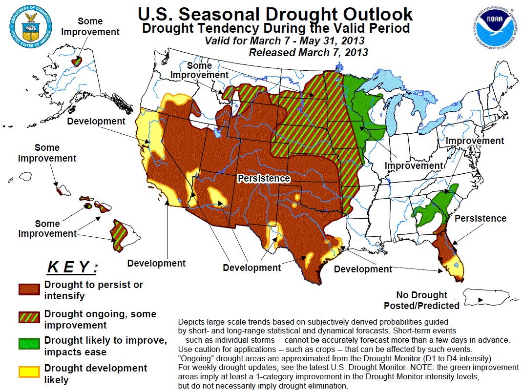
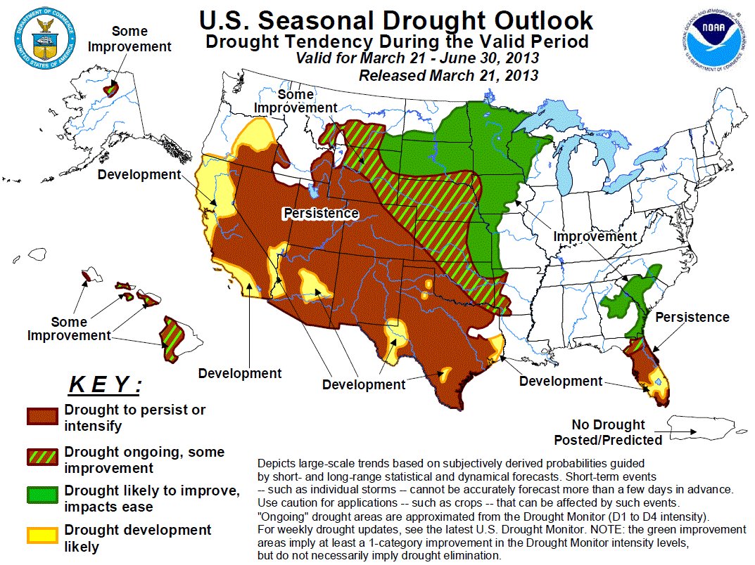
More than 80% of seven states were as of last week in “severe drought,” characterized by crop or pasture loss, water shortage and water restrictions. Depending on whether the hardest-hit regions see significant precipitation, crops yields could fall and drought conditions could persist for months to come. Based on the latest data provided by the U.S. Drought Monitor, 24/7 Wall St. reviewed the seven states running out of water…

Colorado
> Pct. of state in severe drought: 89.0%
> Pct. of state in extreme drought: 48.1% (7th highest)
> Pct. of state in exceptional drought: 21.2% (3rd highest)

Colorado is one of five states where all of its area is considered to be in moderate drought, with nearly 90% of the state experiencing severe drought. With the exception of the Northeast corner of the state, the drought is expected to either persist or get worse over the next several months. Yet even most the Northeast corner is experiencing either extreme or exceptional drought. Due to the ongoing problems, several of Colorado’s largest municipal water providers are considering restricting spring and summer lawn-watering, potentially limiting landowners to watering their grass just twice a week. Crop production declined significantly in 2012 compared to 2011, with wheat production falling 9.3%, while corn production falling a whopping 29%.

From The Greeley Tribune (Eric Brown):

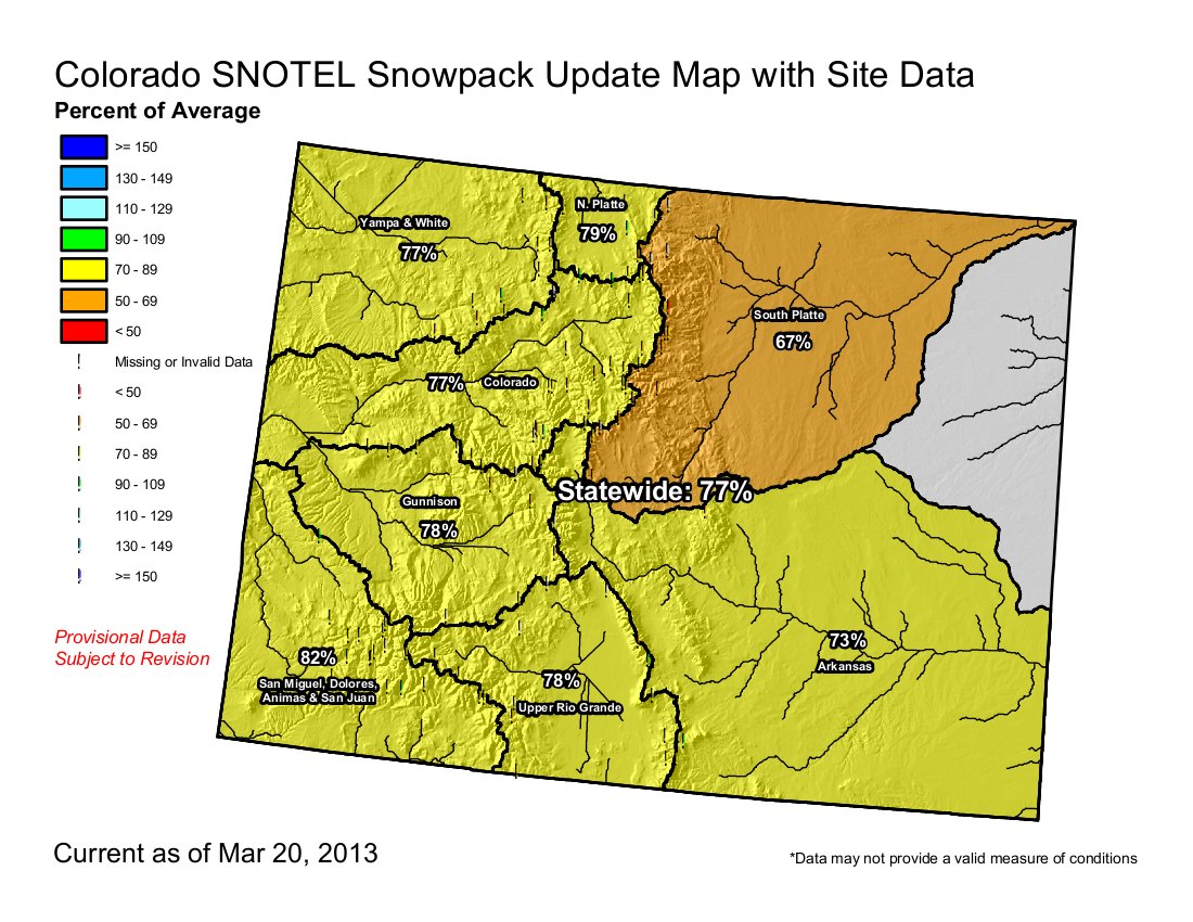
Snowpack in the South Platte basin was only 67 percent of historic average this week, according to the Natural Resources Conservation Service.

Because of the drought that’s plagued the region for months, reservoirs in the South Platte basin were only filled to 82 percent of historic average at the beginning of March, according to NRCS figures.

Statewide, two-thirds of the state’s top soil was “short” or “very short” on moisture, according to a report from the U.S. Department of Agriculture released Monday, and 89 percent of the state’s subsoil was short or very short on moisture.

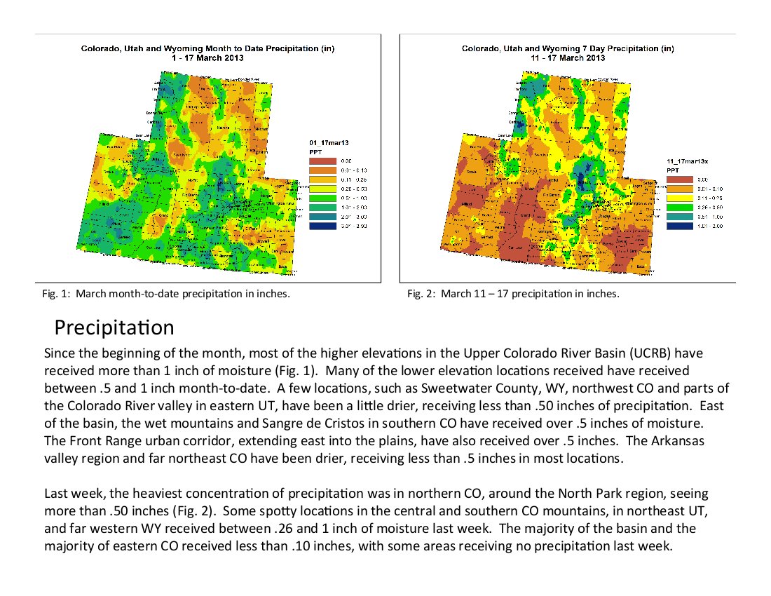
However, some in the South Platte basin are fairing better than others across the state when it comes to moisture. Through Wednesday, Greeley — in the heart of Weld County, where more than two-thirds of the Colorado’s sugar beets are produced — has received about 11 percent more precipitation than average so far in 2013. However, for the entire snow year, dating back to October, Greeley is still about 18 percent behind normal.

From The Durango Telegraph (Tracy Chamberlin):

With persistent drought conditions across Colorado and low reservoir levels in the southwest, water resource managers are looking at a potentially long and arid summer. Following a dry 2012, the warmest year on record, reservoir levels were already on the low side. Reservoir storage exactly one year ago sat at 104 percent of average, which helped the area get through late summer shortages. Currently, it’s only 67 percent of the average and 64 percent of last year, according to the Natural Resources Conservation Service’s monthly snow survey…

Storage levels are down in all of the area’s reservoirs, according to officials from the Bureau of Reclamation. Lemon had 13,962 acre feet of storage in 2012 and now sits at 7,829 acre feet. McPhee was at 287,844 a year ago; the current storage is 188,976 acre feet. And, Vallecito is less than two-thirds what it was last year…

And although much of the state got a boost from the February storms one area that did not was the southwest. The San Miguel, Dolores, Animas and San Juan Basin, which includes the Durango area, saw a decline in its snowpack of 5 percentage points from the February readings. The area snowpack is 83 percent of the average and 89 percent of last year, according to the snow survey. The data collected for the survey “reflects what the state can expect for surface waters supplies this coming spring and summer.”[…]

The Ute Mountain Ute Tribe Farm and Ranch Enterprise, a 7,700-acre agricultural project headquartered in Towaoc, and the Dolores Project irrigators both rely on McPhee. Those groups are potentially looking at about one-third less water this year than they would typically get…

The one thing it won’t help is the boating community. “There’s not going to be a spill [From McPhee Reservoir] this year,” Preston said. Like last year, there just isn’t enough water to release downstream for kayakers and other whitewater enthusiasts. The focus for 2013 is on irrigation and municipalities. Still, the numbers leading off the spring and summer seasons still don’t compare to the record lows of 2002, the year of the Missionary Ridge Fire. “Mother Nature’s really in charge here,” Preston said.

From The Colorado Springs Gazette (Ryan Maye Handy):

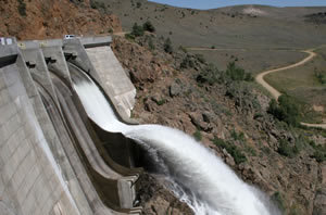
The decision to empty Antero will have a ripple effect for popular reservoirs in the Pikes Peak region and west into South Park. Eleven Mile reservoir, near Lake George, will be lowered in the next couple of weeks to make room for the waters of Antero, Thompson said. While the Eleven Mile might seem low during April, waters should rise again once Antero begins to empty. Eleven Mile, however, is one of two drought reservoirs owned by Denver Water, the reserves of which are only tapped in cases of extreme drought, Thompson said. This spring, Antero, the other drought reserve, will be empty, and Denver Water expects to start tapping Eleven Mile in the next few weeks…

Colorado Springs Utilities has been watching its reservoirs drop as the drought progressed, but it will handle things differently than Denver Water, said Lehermeier. “We are typically moving water in and out of most systems,” Lehermeier said. “There isn’t one that we set aside for a non-rainy day, so to speak.”

But the system of reservoirs that support El Paso County are showing signs of the dry season. Rampart, North and South Catamount reservoirs all are expected to be lower this year. Two other utilities-owned reservoirs in the Blue River water system near Breckenridge are drought impacted — the Upper Blue reservoir, another popular angling spot, is empty. Although the reservoir accounts for a smaller amount of utilties’ water, the fact that it’s empty is a red flag, Lehermeier said.

The One World One Water Center March newsletter is hot off the press

williamsorkdamspill

Click here to read the March newsletter from the One World One Water Center.

More education coverage here.

Northern Water’s Spring Water Users Meeting will be held Thursday, April 11 #codrought

coloradobigthompsonprojecteastslopesystemncwcd

From email from the Northern Colorado Water Conservancy District:

Northern Water’s Spring Water Users Meeting will be held Thursday, April 11 at the Thomas M. McKee Building at The Ranch, Loveland, CO. starting at 8 a.m.

The Spring Water Users Meeting is a forum to discuss the current water situation and water-related issues. The 2013 meeting will include updates on the current water year, the Northern Integrated Supply Project and the Windy Gap Firming Project. Go to the
April Calendar page for more information and to register online. Business group registration is now available. The last day to register online is April 9.

Spring Water Users Meeting Agenda

More Colorado-Big Thompson Project coverage here and here.

Fountain Creek: The Southern Colorado Business Partnership hopes to enable regional cooperation for stormwater management

fountaincreek1999floodcwcb

From The Pueblo Chieftain (Chris Woodka):

A group representing thousands of businesses in Southern Colorado wants to take a crack at calming the waters on Fountain Creek. The Southern Colorado Business Partnership sketched out its plans Tuesday for the Pueblo Board of Water Works. The group wants to launch an effort to clear the air on issues surrounding Fountain Creek sometime later this year. “One of the things we can do is pull the right people together to reach solutions,” said Rod Slyhoff, president of the Greater Pueblo Chamber of Commerce and chairman of the partnership. “We understand the concerns in Pueblo and downstream about Fountain Creek.”

Slyhoff and Randy Scott, the partnership’s president, did not list specific actions about what should be done on Fountain Creek, but said the issue fits into its goal of finding “big picture” solutions to regional problems. The group, which includes chambers and business groups from Castle Rock to Trinidad, represents 5,000 businesses and 150,000 employees, Scott said. It also plans to tackle regional military issues, emergency preparedness, intergovernmental cooperation and air transportation.

Fountain Creek has been a controversial topic for decades. While a watershed improvement district was formed in 2009 after three years of regional meetings, its funding still is in question. An El Paso County stormwater task force reached some conclusions last year, but the level of funding still is at issue because Colorado Springs Mayor Steve Bach is seeking a second opinion on the costs.

Pueblo County commissioners and the Lower Arkansas Valley Water Conservancy District continue to pressure Colorado Springs about controlling stormwater as a condition of its Pueblo County permit to operate the Southern Delivery System.

More Fountain Creek coverage here and here.

The EPA joins Colorado in taking formal action against Williams Energy regarding the Parachute Creek spill #coriver

parachutecreekspillmarch2013

From The Grand Junction Daily Sentinel (Mike Wiggins):

The Environmental Protection Agency has joined state regulators in taking formal enforcement action against an energy company in conjunction with a subsurface leak of thousands of gallons of a liquid hydrocarbon northwest of Parachute.

Meanwhile, the amount of liquid being recovered continues to dissipate, so much so that officials said no measurable amount of hydrocarbon was collected Thursday.

In documents made public Thursday, the EPA issued an administrative order outlining a litany of actions Williams must take to protect nearby Parachute Creek, a tributary of the Colorado River. The order instructs Williams to continue to pump the liquid from existing trenches and potholes, extend the trenches and excavate additional trenches as needed to reduce the threat of the liquid reaching the creek, excavate additional potholes to determine the extent of the plume, install wells to monitor the movement of the plume and routinely collect water samples and conduct daily monitoring of the deployed booms in the creek. The EPA says Williams must submit plans addressing those required actions within seven days and also submit weekly and monthly progress reports.

Williams is already performing most, if not all of the measures required by the EPA. Company officials noted in a news release that crews are collecting samples of creek water on a daily basis and visually inspecting the creek every 30 minutes.

Any violation of the EPA order could be subject to a daily fine of as much as $37,500.

The EPA’s action follows the Colorado Oil and Gas Conservation Commission’s issuance of notices of alleged violation against Williams and WPX Energy.

Williams said Thursday only a sheen of hydrocarbon was recovered Thursday, while 128 barrels of contaminated groundwater — nearly 5,400 gallons — were removed. Altogether, more than 6,000 gallons of hydrocarbon and more than 113,000 gallons of groundwater have been recovered.

Williams first discovered soil contamination March 8 in a pipeline corridor adjacent to its gas plant, which is on land owned by WPX. It was doing pipeline location work in preparation for building a new plant. The source of the hydrocarbon has yet to be identified, and the state, Williams and WPX have yet to agree on what to call the liquid.

State and energy industry officials say there continues to be no evidence of contamination of the creek.

More oil and gas coverage here and here.

The NOAA spring outlook is hot off the press #codrought #cowx

noaatempoutlookapriltojune2013

noaaprecipoutlookapriltojune2013

Click here to read the Spring Outlook from the National Oceanic and Atmospheric Administration. Here’s an excerpt:

NOAA issued the three-month U.S. Spring Outlook today, stating that odds favor above-average temperatures across much of the continental United States, including drought-stricken areas of Texas, the Southwest and the Great Plains. Spring promises little drought relief for most of these areas, as well as Florida, with below- average spring precipitation favored there. Meanwhile, river flooding is likely to be worse than last year across the country, with the most significant flood potential in North Dakota.

“This outlook reminds us of the climate diversity and weather extremes we experience in North America, where one state prepares for flooding while neighboring states are parched, with no drought relief in sight,” said Laura Furgione, deputy director of NOAA’s National Weather Service. “We produce this outlook to help communities prepare for what’s likely to come in the next few months and minimize weather’s impacts on lives and livelihoods. A Weather-Ready Nation hopes for the best, but prepares for the worst.”

The U.S. Spring Outlook identifies the likelihood of spring flood risk and expectations for temperature, precipitation and drought. The outlook is based on a number of factors, including current conditions of snowpack, drought, soil moisture, streamflow, precipitation, Pacific Ocean temperatures and consensus among climate forecast models…

Fifty-one percent of the continental U.S.–primarily in the central and western regions–is in moderate to exceptional drought. Drought conditions are expected to persist, with new drought development, in California, the Southwest, the southern Rockies, Texas, and Florida. The outlook favors some improvement in the Midwest, the northern and central Great Plains, Georgia, the Carolinas, and northern Alaska.

MSU Denver: One World, One Water Center presents ‘Water and the Arts’

justicegregoryhobbscoloradocollegephoto

From YourHub (Tim Carroll) via The Denver Post:

Colorado Supreme Court Justice Gregory Hobbs never expected a poem he wrote about his passion—water—to become the lyrical content of a rap song.

But a rap rendition of his poem, “Colorado Mother of Rivers,” written in celebration of the 30 th year of Colorado’s in stream flow law, was performed by rapper Mr. Figurora at MSU Denver’s first ever “Water and the Arts” symposium. The two-day event on Feb 25-26 brought musicians, authors and artists to Tivoli Turnhalle on the Auraria Campus to raise awareness and explore water issues through the arts.

The event is part of the university’s One World, One Water Center for Urban Water Education and Stewardship initiative, which in addition to bringing water-related events and applied learning activities to campus, also offers an interdisciplinary pilot water studies minor that more than 90 faculty members are involved with.

“The students here at Metro are in a perfect situation,” said Hobbs, who is a member of the One World, One Water advisory board and a co-chair for the “Water and Arts” event. “We’ve identified 100 different courses that have to do with water in some way. English, music, technology of clean water, water infrastructure, engineering, biology…There are so many opportunities for students in the water profession, and this is what this curriculum is trying to do.”

More education coverage here.

Galena fire: Northern Water installs debris booms to mitigate effects to Horsetooth Reservoir #codrought

soldiercanyonfiremarch1520139news

From the Loveland Reporter-Herald (Pamela Dickman):

Northern Water, which oversees the Colorado-Big Thompson water stored in Horsetooth, installed debris boons in 10 locations of Lory State Park to catch any debris, mud or ash before it reaches the reservoir. Crews from the water district will monitor the traps and clean them out to make sure they protect the water.

Similar measures were taken after the High Park Fire and have worked successfully, said Amy Johnson, project manager for Northern Water. The district spent about $15,000 and completed the work in two days, Wednesday and Thursday.

“The reason we started work so quickly was the precipitation forecast this weekend,” said Johnson. “We want to get his in place before any significant runoff.”

The soils are still porous, so some water will absorb to feed grasses expected to sprout this season alongside trees parks staff will plant in the Galena and High Park zones.

“When we get rain and sunshine, we will get grass,” said Butterfield. “It’s going to green up pretty quickly for us, and every little bit of moisture helps.”

From the Fort Collins Coloradoan (Robert Allen):

Ten booms — mesh bags full of wood chips — were placed this week in park drainages to filter moisture entering Horsetooth Reservoir. “They’ll hopefully trap sediment and ash,” said Amy Johnson with Northern Water, adding that similar booms were placed in areas of the park affected by last summer’s High Park Fire. The Galena Fire burned at a lower intensity than the earth-scorching High Park Fire, and the charred remains aren’t expected to have near the impact on water quality.

More Colorado-Big Thompson Project coverage here and here.

Greg Trainor named ‘River Manager of the year’ by the River Management Society #coriver

grandmesa

From the Grand Junction Free Press (Sharon Sullivan):

Trainor was awarded “River Manager of the Year” by the River Management Society at a workshop held at Colorado Mesa University in Grand Junction March 12. The national nonprofit organization’s mission is to support professionals who study, protect and manage North America’s rivers. Its membership includes federal, state and local employees, educators, researchers, consultants, organizations and citizens.

The River Management Society honors those who show leadership in protecting natural, cultural and recreational resources, and who work cooperatively with various user groups and establish long-term partnerships to protect and manage river corridors. “The award is very special, as it is truly peer recognition,” from throughout the nation, said River Management Society president Dennis Willis of Price, Utah.

Trainor, 64, has been a member of the River Management Society for the past 15 years, and currently serves as its secretary. He was editor this past winter of the RMS Journal, for which he has written articles as well as poetry relating to water and the natural world…

A part of Trainor’s job with the city is ensuring that the Persigo Wastewater Treatment Plant discharges meet stringent standards. Trainor is also in charge of catching stormwater and removing trash and other debris from flowing back into the river. Additionally, Trainor works with the U.S. Forest Service, establishing water protection standards as it relates to oil and gas development in the city’s watershed…

Trainor serves on the Colorado River Basin Roundtable, representing municipalities where he helped produce a water and energy report that looked at projected water use of potential oil and gas, uranium, coal and oil shale development through 2050. “As a community we’re connected to the Gunnison and Colorado rivers not only from a utility/public works standpoint, but also more and more from a recreation-related standpoint,” Trainor said. “Those uses are as valid as traditional uses.”

Trainor additionally supports restoration activities along the river, including Tamarisk Coalition efforts to remove the water-hungry invasive species that has crowded out the native cottonwoods in some areas. “I spend time to ensure the Colorado River remains healthy, similar to the goals of the River Management Society,” Trainor said.

Bureau of Land Management: Oil shale and tar sands record of decision hits the street #coriver

oilshaleandtarsandrecordofdecisionmarch2013mapblm

From The Grand Junction Daily Sentinel (Dennis Webb):

The Bureau of Land Management on Friday proceeded with plans to sharply reduce the amount of land available in Colorado, Wyoming and Utah for possible oil shale leasing, and to require a research-first approach.

The agency also said it is seeking public comment on proposed revisions to royalty rates and other regulations applying to commercial oil shale development. It has identified several options for amending the rates, including setting a 12.5 percent minimum royalty rate — the same as for oil and gas leases — with the flexibility of the secretary of Interior to increase it later if warranted. Royalty rates adopted by the administration of George W. Bush consist of a 5 percent initial lease rate that eventually reaches 12.5 percent by the 13th year of commercial production. Interior Secretary Ken Salazar has said that approach shortchanges taxpayers.

The BLM said it has decided to make about 679,000 acres available for potential oil shale leasing in the three states, and 132,000 acres available for potential tar sands leasing in Utah. Only 26,300 oil shale acres are available in Colorado, compared to about 360,000 acres previously. Overall, the oil shale acreage is down from about 2 million acres the Bush administration allocated for potential commercial leasing. In addition, the acreage is available initially only for research, development and demonstration leases, with the ability for companies to convert to a commercial lease after meeting clean air and water and other requirements. “This plan maintains a strong focus on research and development to promote new technologies that may eventually lead to safe and responsible commercial development of these domestic energy resources,” Salazar said in a news release. “It will help ensure that we acquire critically important information about these technologies and their potential effects on the landscape, especially our scarce water resources in the West.”

The Obama administration agreed to reconsider the Bush-area shale land allocations and commercial regulations to settle two lawsuits by conservation groups. Conservationists largely praised Friday’s announced decisions.

Michael Saul, an attorney with the National Wildlife Federation, said it’s important that companies show their projects are economically justifiable and environmentally sound before obtaining commercial leases. “On the whole we think this is a common-sense approach,” he said of the BLM decision.

In a news release, Rifle City Council member and former Mayor Keith Lambert noted that the city long has argued commercial leasing shouldn’t occur until R&D leases show oil shale can be developed responsibly, with minimal impacts. “The city of Rifle appreciates that attention has been given to these concerns as the impacts of oil shale development have been and will be felt in this community and others,” he said.

But Garfield County Commissioner Tom Jankovsky said the BLM’s land decision won’t satisfy the county and commissioners will have to meet “and decide where we’re going to head from here.” Asked where that might be, he said, “There’s only one place to head, the same place the environmentalists go when they’re not satisfied.”

Northwest Colorado counties and several in Utah and Wyoming were concerned about the direction the new land plan was heading. Jankovsky said Garfield commissioners will have to talk to other affected counties and see if there might be some agreement on how to move forward, possibly with litigation. The Colorado acreage made available in the plan is centered in Rio Blanco and Garfield counties, home to what are considered the richest deposits of oil shale in the world.

This oil shale actually is a kerogen that’s locked up in the rock and must be processed through means such as heating to extract it. It differs from the liquid oil now being pulled from shale formations in the United States and other countries through hydraulic fracturing and horizontal drilling.

Western Colorado’s oil shale industry has gone through several booms and busts as companies have sought to develop the resource economically. Several companies now hold federal R&D leases in Colorado and Utah. Brian Straessle, a spokesman for the American Petroleum Institute industry group, said Friday’s decision “takes 1.3 million acres off the table for potential investment in American energy development. That is a step backwards for America’s economic and energy future.”

U.S. Rep. Doc Hastings, R-Wash., chairman of the House Natural Resources Committee, decried locking up land from oil shale development and said the new regulations floated Friday would discourage production. “Today, President Obama is turning his back on new innovation by driving investment overseas and hurting America’s energy security,” he said.

However, U.S. Sen. Mark Udall, D-Colo., who serves on the U.S. Senate Energy and Natural Resources Committee, said, “Oil shale holds great promise for Colorado and the West, but despite decades of trying to extract shale oil, there has not yet been an economical or ecologically feasible method to develop it. The Interior Department’s plan will ensure that commercial oil shale development is feasible and sustainable before leases are issued. It also will make sure that we do not sacrifice our most precious resource, water, in pursuit of oil shale development.”

Said Bill Midcap of the Rocky Mountain Farmers Union, “The plan just makes all kinds of sense when it comes to conserving our water resources.” Midcap praised Salazar’s leadership. “He’s brought a lot of common sense to oil shale, (common sense) that we value out here in the West, something we need more of in this country,” Midcap said.

Friday’s oil shale announcements come as Salazar is just about to leave office. The proposed royalty and other regulatory changes also come more than 10 months later than when the Interior Department had committed to proposing them under the lawsuit settlement agreement.

More oil shale coverage here and here.

Cotter Corp, Inc. announces plan to mitigate uranium contaminated groundwater at the Schwartzwalder mine

schwartzwalderminelocationmap

From The Denver Post (Bruce Finley):

Cotter Corp. is preparing to brew a multimillion-gallon uranium cocktail in a mine shaft west of Denver — an innovation aimed at ending a threat to city water supplies.

If all goes well, mixing molasses and alcohol into a stream of filtered water pumped from the mine and discharged down Ralston Creek, and then re-injecting that mix into Cotter’s 2,000-foot-deep Schwartzwalder mine, will immobilize uranium tainting the creek. Bacteria inside the mine will devour the molasses and dissolved uranium, creating solid uranium particles that will settle at the base of the mine, Cotter vice president John Hamrick said. “We believe we can get the water to such a state that it would be OK to let it come out,” Hamrick said in an interview. “We’re using our best efforts to do this as quickly as we can.” Bacteria “will eat the uranium to live, and part of what they excrete, or the byproduct of that, is a solid particle that will fall down to the bottom of the mine.”

The U.S. Environmental Protection Agency has approved Cotter’s project and state regulators were reviewing it.

Such “bioremediation” would save Cotter tens of millions of dollars as an alternative to perpetually pumping out and treating mine water laced with uranium — which reached concentrations as high as 24,000 parts per billion inside the mine shaft, well above the 30 ppb federal drinking water standard…

“The potential is there for this process to work,” EPA environmental scientist Craig Boomgaard said. “Another form of it is being done at Asarco’s smelter in Denver. Is it solution? I can’t say. But in certain cases it is demonstrated to be effective.”[…]

State regulators’ order to pump out and treat uranium-laced water from the mine “has been in place for quite a while and the mine pool drawdown has not yet commenced,” the statement said. “We are eager to see the company move forward.”

More Schwartzwalder mine coverage here.

U.S. Representative Diana DeGette’s hydropower bill is still on track

microhydroelectricplant

From The Denver Post (Mark Jaffe):

…turning flowing water into small hydropower projects is not easy. Even a tiny ranch project requires almost the same paperwork for a federal permit as the Hoover Dam. A bill exempting small projects from the voluminous federal filings — co-sponsored by Rep. Diana DeGette, D-Denver — passed the U.S. House of Representatives 422-0 in February. Last year, a similar bill, also co-sponsored by DeGette, passed the House unanimously but died in the Senate. But this time may be different.

On March 13, companion legislation to the new hydro bill was introduced in a Senate committee with Democratic and Republican sponsors. “We are always talking about streamlining government,” DeGette said. “This is streamlining government.”

The legislation would exempt projects of up to 5 megawatts from the Federal Energy Regulatory Commission requirements. Getting rid of the FERC permit could open several hundred sites in Colorado with a combined capacity of 1,400 megawatts — equal to two power plants, according to the commission.

Small municipal and private hydro plants generate about 662 megawatts of electricity in Colorado, according to a Colorado State University study. There are 200 megawatts of small projects that are likely to be developed, said Kurt Johnson, president of the Colorado Small Hydropower Association…

FERC permitting can run from $10,000 to $30,000, which can be more than the cost of many projects, said Johnson.

More hydroelectric coverage here and here.

2013 Colorado legislation: HB13-1248 gets a rewrite to expand its reach statewide #coleg

rockyfordditch

From The Pueblo Chieftain (Chris Woodka):

A late bill in the Colorado Legislature would allow the Colorado Water Conservation Board to administer three pilot projects to test water leasing strategies. The bill, HB1248, was introduced earlier this month and is sponsored by Randy Fischer, D-Fort Collins, and Sen. Gayle Schwartz, D-Snowmass Village. They chair legislative agriculture committees. As written, the bill applied only to the Arkansas River Basin. Fischer sent it to a subcommittee to rewrite the bill to apply it to the entire state and to clarify the role of the state engineer in approval of plans. It should be heard in committee this week.

The bill would give the CWCB authority over the pilot projects for one 10year period to demonstrate how irrigated agricultural land could be fallowed and the water temporally leased for municipal use, along the lines proposed by the Arkansas Valley Super Ditch. CWCB board member Alan Hamel said the board already has funded several projects looking at the impact of leasing programs like Super Ditch.

A similar bill, HB1130, seeks to extend state engineer approval of interruptible water supply agreements for up to 30 years. The agreements now can be operated three years out of a 10-year period. The bill would allow that period to be renewed twice. The bill, backed by Aurora, passed the House last month, but has yet to be heard in the Senate ag committee.

Other water bills:

SB19, allowing water rights to be temporarily used for conservation purposes without penalty to consumptive use calculations, passed the Senate, but reportedly has been amended in the House to exclude water divisions 1, 2, 3 and 7.

SB41, protecting stored water for drought and long-term needs, passed both houses.

SB74, concerning ambiguities of water rights, passed both houses. The bill was amended from its original form to give water judges leeway in determining how much acreage historically was irrigated.

SB181, the water projects bill, passed the Senate and is in the House ag committee. It includes $72 million in water projects administered by the CWCB.

More 2013 Colorado legislation coverage here.

The CWCB approves dough for three Arkansas Basin Roundtable projects

arkansasriverbasin

From The Pueblo Chieftain (Chris Woodka):

Three Arkansas River basin projects gained approval last week from the Colorado Water Conservation Board. A new water line for the Ordway Feedyard, bank stabilization on the Frost Ranch on Fountain Creek and a study of historic flows and diversions were approved.

The Ordway Feedyard received a $275,000 grant and $2.5 million loan for a $3.2 million project to complete a 10.5-mile pipeline. The pipeline would provide fire protection, as well as saving about 800 acre-feet of water, said Alan Hamel, CWCB board member. The new pipeline would replace a gravity-flow pipeline from Lake Henry with a system that pumps the water uphill. The feedlot needs as much water as a city of 5,500 people would require for its 65,000 head of cattle. It’s the third-largest employer in the county and has a $50 million impact annually on the local economy. It was built in 1972, but the owners subsequently sold off most of the water rights to large cities.

The Fountain Creek Watershed Flood Control and Greenway District received $105,000 for a bank stabilization project on the Frost Ranch on Fountain Creek in El Paso County. The project would demonstrate methods that other landowners along the creek could use to reduce erosion and sedimentation. The total project is about $160,000.

The Southeastern Colorado Water Conservancy District received a grant of $300,000 for a study of weather patterns and water diversions, with a goal of better understanding how water is used in wet and dry years. The study will also distinguish between native water and water imported into the basin. “We need an accounting tool that tells us how much water is available through native or imported sources, how much is in storage and how much can be exchanged,” said Jim Broderick, executive director of the Southeastern district.

All three grants were approved by the Arkansas Basin Roundtable and funded through the water supply reserve account, which comes from mineral severance taxes.

More CWCB coverage here.

Rio Grande Compact Commission meeting recap: Texas lawsuit with New Mexico delays final accounting

riograndebasin100thmeridianorg

From The Pueblo Chieftain (Matt Hildner):

A dispute with Texas over the calculation of water deliveries under the Rio Grande Compact won’t have an impact on how Colorado manages its share of the river in the San Luis Valley. Craig Cotten, the division engineer for the valley, said the difference in calculations was roughly 300 acre-feet. “It’s a very small amount of water,” he said.

The amount of water in the Rio Grande that has crossed the Colorado state line in the last decade has ranged from as little as 68,000 acre-feet in the drought year of 2003 to as much as 430,000 acre-feet in 2005.

Colorado and New Mexico have disagreed with Texas over how the Bureau of Reclamation has calculated evaporation rates from a pool of credit water contributed by the upstream states that ends up in Elephant Butte Reservoir. Cotten said Colorado and New Mexico would prefer to see the calculations done at the end of the year as opposed to a running basis.

The dispute, which started in 2011, prevented the three states from signing off on the final delivery totals at Thursday’s meeting of the Rio Grande Compact Commission. The calculation of evaporation rates in the pool of credit water is the subject of a lawsuit between New Mexico and the bureau in U.S. District Court in New Mexico.

More Rio Grande River Basin coverage here and here.

Arkansas River Valley well users may end up owing water to the river from 2012 #codrought

typicalwaterwell

From The Pueblo Chieftain (Chris Woodka):

More bad news for farmers. Earlier this year, groundwater associations determined that there would be limited or no replacement water for wells in the Arkansas Valley. Upon reviewing plans submitted March 1, the state is working with the well groups to determine if more water still is owed from 2012. “Depletions have occurred that have not been paid back,” Division 2 Engineer Steve Witte told the Southeastern Colorado Water Conservancy District Thursday.

Witte’s staff is reviewing wellpumping plans from the three large well groups to determine how much water might be owed under Rule 14 of the 1996 Arkansas Valley groundwater rules. It could mean a ban on pumping or allowing minimum pumping to occur this year. The state also is looking at domestic and municipal users who may need to implement restrictions in order to keep wells operating this summer. “We are encouraging conservation measures to meet critical needs,” Witte said.

One well association, the Arkansas Groundwater Users Association, factored the 2012 depletions into its 2013 Rule 14 plan, said manager Scott Lorenz after the meeting. He said farmers should be able to pump at 30 percent on the mainstem of the Arkansas River and 48 percent on Fountain Creek. The Colorado Water Protective and Development Association informed its members who did not have their own sources of replacement water that no water would be available. The Lower Arkansas Water Management Association plan called for 30 percent pumping.

The Southeastern board received more gloomy news about snowpack and stream flow conditions. Fryingpan-Arkansas Project Flows could be as low as last year — the second-lowest on record — while storage and soil moisture conditions are even worse.

arkansasvalleyconduitproposed

Meanwhile the Southeastern board also heard an update for the Arkansas Valley Conduit. Here’s a report from Chris Woodka writing for The Pueblo Chieftain:

A route for the Arkansas Valley Conduit will be recommended when the final environmental impact statement is released later this year. It could be a hybrid of alternatives being studied by the federal Bureau of Reclamation, which can match components of various alternatives. “The Pueblo routes have raised concerns about what’s already in the ground, so the goal is to find a route that alleviates concerns without additional costs,” Southeastern Colorado Water Conservancy District Executive Director Jim Broderick told the district board Thursday.

Reclamation still is working on cost-benefit ratios for the project, which includes storage in Lake Pueblo for the conduit and other needs.

The estimated cost of the conduit, which will provide clean drinking water to 50,000 people in 40 communities east of Pueblo, is $500 million. But that could be high because of standard contingency rates added to early stages of construction projects. Benefits are likely to be in the $500 million range as well, said Broderick, who traveled to Washington, D.C., last month to discuss the project with federal officials.

No route for the pipeline was recommended in the draft environmental impact statement last year, but routes through Pueblo and south of the city are being considered. But the routes generated concern with the city of Pueblo. On Oct. 29, Pueblo interim City Manager Jim Munch, in a comment to Reclamation saying that any of the routes for the underground pipeline through the Pueblo area have the potential to interfere with infrastructure. Pueblo’s letter also detailed concerns about how water quality could be affected by reduced flows in the Arkansas River through Pueblo.

The city’s comments were among 25 received by Reclamation. Most dealt with mapping errors or water quality concerns.

More Arkansas River Basin coverage here and here.

San Luis Valley water is safe from the USFWS and the southwestern willow fly-catcher

southwesternwillowflycatcher

From The Pueblo Chieftain (Matt Hildner):

A federal wildlife manager assured Colorado officials Thursday that the protection of habitat for an endangered bird would not lead to demands on the state to relinquish water.

In January, the U.S. Fish and Wildlife Service designated critical habitat for the southwestern willow flycatcher along 23 miles of the Rio Grande and a 2.9mile stretch of the Conejos River. “The designation itself does not affect water delivery or water users,” Wally Murphy, who oversees the U.S. Fish and Wildlife Service’s protection of endangered species in New Mexico, told the Rio Grande Compact Commission.

San Luis Valley water officials had been alarmed by the January designation after spending years working on a habitat conservation plan to protect the bird’s habitat on private land in the valley. The service excluded 114 miles of private stream bank along the Conejos and Rio Grande that were covered in the conservation plan.

But State Engineer Dick Wolfe, who represents Colorado on the commission, pressed Murphy on whether the operations of Platoro Reservoir or the Closed Basin Project might be impacted. “Habitat is ultimately driven by water to some extent so it seems like there is a nexus there,” Wolfe said.

Murphy said there would be no call for water. Platoro, which has a capacity of 59,000 acre-feet and sits near the Continental Divide, provides flood control and irrigation water for farmers and ranchers along the Conejos. The Closed Basin Project draws groundwater from the northeast corner of the valley and sends it downstream to assist with Colorado’s requirements under the compact.

More endangered/threatened species coverage here and here.

The Fountain Creek District is sorting through funding options and projects

fountaincreekwatershed

From The Pueblo Chieftain (Chris Woodka):

It’s like anticipating a wall of funding options rushing at you. Funding for water projects on Fountain Creek, that is.

The Fountain Creek Watershed Flood Control and Greenway District Friday looked at multiple efforts in El Paso County to answer questions about what should be funded, how money can be raised and when voters should be asked to support those projects. Tied up in the study is the continuing question of what role the district should play and how it will get the money it needs to carry out its own goals. “We need a timeline, so we have concrete steps we can take,” Pueblo Councilwoman Eva Montoya said. “We need a plan.”

The district is considering what questions it needs to ask in polling voters in El Paso and Pueblo counties about the possibility of a mill levy, how a question would be worded and when to place the issue on the ballot. Even after those questions are decided, there are questions about how to pay for an election and how to fund the campaign for a mill levy, since government groups could not pay for it.

At the same time, three separate investigations are proceeding in El Paso County — all of them related to Fountain Creek and potentially involving the Fountain Creek district.

● An El Paso County stormwater task force is trying determine priorities and funding sources for flood control. The Fountain Creek district board voted to manage a technical study, which would be funded by Colorado Springs Utilities and El Paso Coun ty. The study was suggested by Summit Economics, which launched the task force with an earlier white paper.

● Colorado Springs is reassessing its stormwater needs at the request of Mayor Steve Bach. A contractor will be chosen in April.

● The Coalition of the Upper South Platte is working with community groups to determine rehabilitation strategies for the Waldo Canyon burn scar.

Lurking in the background is the Southern Colorado Business Partnership, which announced its intention to seek a regional solution for Fountain Creek to the Pueblo Board of Water Works earlier this week.

More Fountain Creek coverage here.

Bureau of Land Management: Oil shale and tar sands record of decision hits the street #coriver

oilshaleandtarsandrecordofdecisionmarch2013mapblm

Click here to read the ROD. Here’s the introduction:

This Record of Decision (ROD) approves the Bureau of Land Management’s (BLM’s) proposal to amend 10 Resource Management Plans (RMP) to designate certain public lands, managed by the BLM, in Colorado, Utah, and Wyoming as available for application for leasing and future exploration and development of oil shale and tar sands resources. This ROD does not address, and does not change, any decisions for the management of the public lands for other resource uses and values in the areas subject to these 10 RMPs. The RMP amendments were described as the Proposed Plan Amendments in the November 2012 Proposed Land Use Plan Amendments for Allocation of Oil Shale and Tar Sands Resources on Lands Administered by the Bureau of Land Management in Colorado, Utah, and Wyoming and Final Programmatic Environmental Impact Statement (PRMP/FPEIS) (BLM 2012a). This ROD provides the background for the development of the plan amendments, describes in brief the alternatives considered, and presents the rationale for approving the proposed decisions contained in the Proposed Plan Amendments. In addition, the ROD describes the clarifications and modifications made to address protests received on the plan amendments. The BLM’s purpose and need for this planning action is to evaluate the appropriate mix of allowable uses with respect to oil shale and tar sands leasing and potential development in light of Congress’s policy emphasis on these resources. Specifically, as adopted, the Proposed Plan Amendments amend the applicable RMPs to close certain specified areas in Colorado, Utah, and Wyoming currently open for application for future leasing and development of oil shale or tar sands. The BLM’s focus in this planning initiative is the potential development of oil shale and tar sands as sources of energy, consistent with congressional policy as expressed in the Energy Policy Act of 2005, which required that a commercial leasing program be established for these resources. Under the approved 2013 land use plan amendments, the BLM amends 10 land use plans in Colorado, Utah, and Wyoming to make approximately 678,000 acres available for potential development of oil shale, and approximately 132,000 acres available for development of tar sands.

This ROD provides that the areas allocated as open for future oil shale leasing are, at this time, open only to research, development, and demonstration (RD&D) leases. The BLM would issue a commercial lease only when a lessee satisfies the conditions of its RD&D lease and the regulations in the Code of Federal Regulations, Title 43, Subpart 3926 (43 CFR Subpart 3926) for conversion to a commercial lease. The preference right acreage, if any, which would be included in the converted lease, would be specified in the RD&D lease. Similarly, while there is no formal RD&D program for tar sands, this resource is not, at present, a proven commercially viable energy source. Therefore, the BLM has determined that it is necessary to obtain more information about the environmental consequences associated with tar sands development, prior to committing to broad-scale commercial development.

The land use plan amendments remove from potential oil shale and tar sands leasing the following categories of lands within the planning area in Colorado, Utah, and Wyoming (1) all areas that the BLM has identified as having wilderness characteristics (LWC) (2) the whole of the Adobe Town “Very Rare or Uncommon” area, as designated by the Wyoming Environmental Quality Council on April 10, 2008; (3) core or priority sage-grouse habitat, except in Wyoming, where the BLM will coordinate its approach with the policy direction in Wyoming’s Executive Order (E.O.) 2011-5, which has been recognized by the U.S. Fish and Wildlife Service (USFWS) as an adequate regulatory mechanism for the conservation of Greater Sage-Grouse; (4) all Areas of Critical Environmental Concern (ACECs) and areas currently under consideration for designation as ACECs; and (5) all areas identified as excluded from commercial oil shale and tar sands leasing in Alternative C of the September 2008 Oil Shale and Tar Sands (OSTS) Programmatic EIS (BLM 2008a). In total, more than 1,340,770 acres of the planning area in Colorado, Utah, and Wyoming are excluded from oil shale leasing and development, and more
than 301,100 acres in Utah are excluded from tar sands leasing and development.

If and when applications to lease are received and accepted for oil shale or tar sands resources within the acres available for leasing under this ROD, the BLM will conduct additional required analyses, including consideration of direct, indirect, and cumulative effects of the proposed development, reasonable alternatives, and possible mitigation measures. On the basis of that analysis of future lease application(s), the BLM will establish general lease stipulations and best management practices (BMPs) and amend applicable land use plans, if necessary. After a lease is authorized, actual development will require additional analysis to address the site-specific conditions of the proposed development and to develop mitigation measures as necessary. The attached RMP Amendments to Address Land Use Allocations in Colorado, Utah, and Wyoming (Attachment — Appendix A) (also referred to as the Approved Plan Amendments) describes the specific decisions made in this ROD.

More oil shale coverage here and here.

Drought/snowpack news: Colorado Springs Utilities calls for drought restrictions #codrought

seasonaldroughtoutlookclimatepredictioncenter03212013

usdroughtmonitor03192013

From The Colorado Springs Gazette (Barbara Cotter):

Wayne Vanderschuere, general manager of water services, said conditions are bad enough to restrict turf watering to one day a week. But Utilities officials hope that a two-day schedule, coupled with an intensive consumer education program and tariffs for high water usage, will accomplish the goal of maintaining a one-year reserve of water and saving 5.8 billion gallons during the April 1-Nov. 1 irrigation season.

The final decision rests with City Council, which will take up the proposal at its formal meeting Tuesday.

There are indications that the council won’t rubber-stamp Utilities’ recommendations, however. In previous discussions, council member Angela Dougan asked about what could be accomplished with a three-day-a-week schedule, and a landscaping contractor — at the invitation of councilman Tim Leigh — argued at a recent meeting that limiting people to two days of watering will be “devastating” to their yards.

But Utilities officials continued to paint a dire water picture at a meeting Wednesday of the Utilities Board, made up of City Council members. Utilities CEO Jerry Forte told the board that recent data on snowpack, reservoir levels, drought forecasts and other factors reinforced the decision to recommend the two-day-a-week watering schedule.

“We’re predicting yields to be estimated at about 51 percent of normal,” said Abigail Ortega, a Utilities planning supervisor. “This would be, if it does continue, our lowest yield on record, and the second year in a row.”

One group of residents might escape the watering restrictions, at least temporarily. Vanderschuere said Utilities will present a resolution to Council on Tuesday that would allow people whose landscape was damaged by the Waldo Canyon Fire to temporarily escape the watering restrictions and tariffs. Under the proposal, they could get up to two 28-day permits to help re-establish their landscaping. Permits would cost $50.

Forecast news: Widespread snowfall predicted for Denver Metro area and eastern plains for the weekend #codrought #cowx

snowflakesbentley

From The Denver Post (Kieran Nicholson):

Friday in Denver will be a bit of a transition day, with a 30 percent chance of showers after 1 p.m. and a high temperature near 44 degrees, the weather service reports. Friday night there’s a chance of mixed rain and snow before 10 p.m., then snow likely. It will be mostly cloudy with a low of 25 degrees. Denver has a 70 percent of snow and up to 3 inches is possible, forecasters said. Saturday could bring another 3 to 7 inches of snow to the city. Sunday has a 20 percent chance of snow…

Across most of the Eastern Plains, a winter storm watch is in effect from late Friday night through Saturday afternoon, with rain turning to snow Friday night. Up to 6 inches of show could be pushed by wind gusts up to 45 mph…

Temperatures across northeastern Colorado will be about 30 degrees lower than seasonal norms Saturday through Monday before a slow, moderate warming trend, with a forecast of 34 on Tuesday, 41 Wednesday and 43 on Thursday.

From The Greeley Tribune (Mike Nelson):

Friday night, the snow will start to fall in Weld County and continue through the night into the afternoon on Saturday. High temperatures in Greeley on Saturday will drop into the upper 20s. Three to six inches is possible.

The snow quickly ends Saturday afternoon and it will stay cold, but dry through Sunday. A new storm will bring snow back to the mountains Sunday evening and into the Front Range by Monday morning. It will not be a big storm, but may produce 4-8 inches in the mountains and another couple of inches in Denver by Monday morning rush, so plan ahead.

From the National Weather Service Pueblo office:

Unsettled weather will spread across the region this weekend, as our next low pressure system begins affecting the weather over eastern Colorado this afternoon into Saturday night. This low will bring a good chance for precipitation to the central and eastern mountains, and much of the northeastern plains, including the Palmer Divide and Kiowa County by this afternoon and continuing into Saturday evening. The chances for precipitation will gradually spread south across the remainder of eastern Colorado on Saturday, before diminishing late Saturday night as the low moves east of the state. A brief break in the weather was expected across much of eastern Colorado on Sunday before yet another storm system approaches Sunday night into Monday, with an increased chance for precipitation expected area wide. Temperatures will cool into the 40s and 50s over most locations today, then falling off into the 20s and 30s over the weekend.

Southern Delivery System: CSU is turning dirt for the new water treatment plant

sdspreferredalternative

From The Colorado Springs Gazette (Ned B. Hunter):

Ground was broken Wednesday for the plant, part of the Southern Delivery System that will deliver water from the Pueblo Reservoir to Colorado Springs, Fountain, Security and Pueblo West…

The 82,000 square-foot water treatment plant will use ozone/biological filtration to treat water piped from the Pueblo Reservoir. The plant’s capacity can be expanded to treat up to 130 million gallons of water per day based on future demand.

Construction of the plant, one of the largest components of SDS, comes as the Colorado Springs area continues to see an unemployment rate above the national and state rates; the Springs jobless rate was 9 percent in December.

More Southern Delivery System coverage here and here.

The Rio Grande Headwaters Land Trust 2012 Annual Report is hot off the press

sanluisvalleyearlywinterriograndeinitiative

From email from the Rio Grande Headwaters Land Trust:

We had a great year in 2012 and wanted to share our Annual Report with our friends and supporters who made it happen. Click here to go directly to the report on our website.

More Rio Grande River Basin coverage here and here.

Interbasin Compact Committee: Draft Nonconsumptive Toolbox Request for Public Comment

highparkfiredenverpost06142012

From email from the IBCC (Becky Mitchell):

Below is the link to the Draft Nonconsumptive Toolbox.

The IBCC requested that CWCB develop a toolbox to help roundtables incorporate nonconsumptive needs into their Basin Implementation Plans. This is a resource document for the roundtables and other stakeholders, and brings many documents and technical work together in one place.

The draft report is available online here: http://cwcbweblink.state.co.us/weblink/0/doc/170187/Electronic.aspx?searchid=ee0c3336-ec13-43aa-8b81-460b87f065af

The report has been reviewed by CWCB staff and the IBCC subcommittee, which includes a diverse set of environmental, municipal, and agricultural interests, and is now available for public comment.

Please provide your comments by close of business Monday, May 20th to IBC@state.co.us.

As directed by the CWCB Board, staff will review the document with the roundtable chairs, and be available upon request to present the draft document to basin roundtables. Once the document is finalized, staff will present it along with the technical platform and framework for the consumptive portion of the basin implementation plans to each of the roundtables.

More IBCC — basin roundtables coverage here.

‘Watershed restoration funding back on track in Colorado’ — Bob Berwyn

highparkfiredenverpost06142012

From the Summit County Citizens Voice (Bob Berwyn):

Persistence by Sens. Mark Udall and Michael Bennet paid off this week, as the U.S. Senate passed legislation that includes $65.5 million to help communities like El Paso County and Larimer County repair watersheds damaged in last summer’s wildfires. Udall said it was a major victory for Colorado, with Emergency Watershed Protection (EWP) program funds also included in the Continuing Resolution that passed the U.S. House of Representatives.

The money will help Colorado communities affected by the devastating High Park and Waldo Canyon fires to deal with degraded water quality, high flooding risk and eroded watersheds…

The Emergency Watershed Protection program supports efforts to restore eroded watersheds and damaged drinking water infrastructure. Udall and Bennet have led the fight to secure funds since the devastating 2012 wildfire season. As a result of the historic High Park Fire in northern Colorado, the area supplying drinking water to communities including Greeley and Fort Collins has a high risk of flooding, road washouts and water quality degradation.

Similarly, in Colorado Springs, utility infrastructure was badly damaged in the wake of last year’s wildfire season.

From the Colorado Springs Independent (J. Adrian Stanley):

The summer monsoon season approaches, and 18,247 acres of blackened earth waits, ready to unleash a fury that could prove more damaging than the fire that killed two people and destroyed nearly 350 homes. Experts agree: One fast, hard rainstorm over the Waldo Canyon burn scar could send a torrent downhill, taking houses, businesses, roads, utility lines and lives.

It could come in the afternoon, rushing toward crowds of tourists in downtown Manitou Springs. It could come in the middle of the night, catching Pleasant Valley neighborhood residents as they sleep.

Some who watched the Waldo Canyon Fire approach through their windows may feel they know the drill: Pack your bags and wait for the knock on the door. But most will receive no such direct warning in a flood evacuation. In fact, those who have studied our risk say they are struggling to relay a single, essential message: You’re on your own this time around, and you’d better be ready.

Carol Ekarius, executive director of the Coalition for the Upper South Platte, has directed fire and flood recovery work for the 2002 Hayman Fire and other large burns. She’s seen her share of devastating floods. Still, in terms of flood risk, she calls Waldo “the scariest fire in the country.”

From the Loveland Reporter-Herald (Pamela Dickman):

The U.S. Senate passed legislation Wednesday containing $65.5 million in emergency watershed protection — a step closer to getting that money to communities in need, including Larimer County for mulching and seeding ground charred by the 2012 wildfire.

The U.S. House version of the legislation allocated $48 million for emergency watershed protection, so a committee from both arms of government must meet and agree on a number somewhere in that range, then President Barack Obama must sign the bill.

Then the money can start funneling into the communities in need and work can begin.

Realistically, work is four to six weeks out because of the process, said Todd Boldt, resource specialist for the Natural Resources Conservation Service.

Officials expect about $20 million to come to Colorado, and about half of that to Larimer County. The money will go to mulching and seeding hillsides and slopes that were burned by the High Park fire as well as other measures to reduce the impacts of rain on the slopes.

From The Denver Post (Allison Sherry):

While local officials will still have to compete for the money, it is assumed the state’s needs for forest and water storage repair are stark enough to warrant grants.

“It’s really good news for El Paso and Larimer County and the whole state,” said El Paso County Commissioner Sallie Clark on Wednesday. Clark has personally flown to DC several times to lobby on behalf of her county, which was devastated by the Waldo Canyon Fire last year. “We don’t know exactly how much were going to get on this.”

Sen. Michael Bennet, a Democrat, said he was proud of the state delegation’s bipartisan effort to get the money. “I’m grateful for the efforts of our state’s delegation, which worked together in this fight to secure these critical funds for Colorado,” he said, in a statement. “Passing this bill … will allow these communities to take the next step to complete the recovery process. These funds will help restore our land and repair critical infrastructure to help prevent larger costs and bigger problems down the road.”

2013 Colorado legislation: SB13-183 passes out of the state senate #coleg

coloradocapitolfront

From The Colorado Springs Gazette (Bill Vogrin):

Under SB 183, HOAs would not be able to fine homeowners whose lawns die because they observe watering restrictions, which are anticipated this summer amid the current drought. It also overrides any covenants that demand water-guzzling turf lawns and ban xeriscape landscaping methods featuring drought-tolerant plants. The bill has passed the Senate and is awaiting action in the House.

More 2013 Colorado legislation coverage here.

Forecast news: Mountain snow, valley rain in western Colorado today #codrought #cowx

From the National Weather Service Grand Junction office:

A storm system and associated cold front will move through the region today, bringing mountain snow and valley rain through this evening. Some isolated thunderstorms are possible. Storm total snowfall amounts of 4 to 8 inches with locally higher amounts are expected in the western Colorado mountains, with 1 to 3 in the Gunnison basin. 3 to 5 inches can be expected near Cerro Summit. Mainly rain will occur in valleys below 8000 ft, with the exception of some northern Colorado valleys where snow levels will be at valley bottoms this morning, with little accumulation expected. After a brief break tonight into Friday morning, a colder storm system will move through the area Friday evening through Saturday. Unsettled conditions look to remain over the area through early next week, with a return to unseasonably cool temperatures.

Drought/snowpack news: Streamflow in the Arkansas and Colorado rivers expected to be 56% of avg this season #codrought

snowpackcolorado03202013

usdroughtmonitor03122013

The winter water storage program on the Arkansas River hit a record low this season. Here’s a report from Chris Woodka writing for The Pueblo Chieftain:

The winter water storage program hit its lowest level since its inception in the 1970s, as drought continues in the Arkansas River basin. The winter water program, which began Nov. 15 and ended Friday, stored only 67,167 acre-feet, less than half of average and 90 percent of the 2002-03 total, according to the final accounting released Tuesday. That’s more bad news for farmers, who already face poor soil moisture, reduced flows and in some cases well shutdowns for lack of replacement water.

Cities also are affected. “We did not get a lot of help from winter storage,” Alan Ward, water resources manager for the Pueblo Board of Water Works said. The water board is able to store in its own Clear Creek Reservoir, Twin Lakes and Lake Pueblo during the storage program, and recorded about 2,500 acre-feet, about 70 percent of average. Pueblo’s storage is 40 percent of average, and just 69 percent of the levels last year.

While the water board has put spot leases on hold this year, no mandatory outdoor water restrictions are planned. “As long as our direct flow rights stay in priority, we’re not anticipating moving into restrictions,” said Executive Director Terry Book. The board will continue to monitor conditions and may make a slight change in drought conservation policy at its April meeting.

Snowpack lags last year in the Arkansas River basin, at 75 percent of average, while it’s 72 percent of average in the Colorado River basin. Pueblo gets about half its water supply from diversions over the Continental Divide. “We’re beginning to see fairly regular showers in Leadville,” Ward said. “After such a slow start, we’re keeping pace, but not catching up.”

Stream flows are projected to be at about 56 percent of average this year in both the Arkansas and Colorado river basins.

From The Pueblo Chieftain (Chris Woodka):

St. Charles Mesa Water District customers are being asked to reduce outdoor water use as drought continues in Southern Colorado. The district has sufficient water, with storage at 85 percent of capacity, and flows in the Bessemer Ditch at 71 cubic feet per second.

“At that rate the district should be able to maintain its storage and refill this spring. We have Fryingpan-Arkansas Project water in Pueblo Reservoir as a reserve and will use a small portion in 2013,” said Manager David Simpson. “If conditions remain the same in 2013 we would have the project water available for 2014.”

The district is asking its customers to reduce their outdoor irrigation. “Watering one time per week helps establish the lawn root system,” Simpson said. “Watering two to three times per week for short periods does not allow the water to soak into the soil.”

From the Broomfield Enterprise (Megan Quinn):

Broomfield is weighing options on how it gets its water supply, but won’t know until April whether the city will get a reduced amount from one of its main water sources. In April, Broomfield’s two main water suppliers will announce how much water municipalities will receive for the year, City and County Manager Charles Ozaki said during the City Council meeting Tuesday. Broomfield could then decide to buy more water from certain suppliers or ask residents to make changes to save water, he said.

The city has not announced any water restrictions for residents, at least for now. “A lot depends of the type of weather we will have in the next couple weeks, but it is more and more likely that restrictions will imposed” in places that might affect the city’s supply, such as the Denver Water Board, Ozaki said.

Broomfield gets a portion of its water from Denver Water, and as part of its contract, Broomfield must follow any water restrictions the board puts in place. For example, if Denver Water implements a 20 percent water use reduction plan, Broomfield would have to reduce the amount of treated water it receives from Denver Water by 20 percent. That would add up to about 8 percent of Broomfield’s total water supply, according to a staff memo. Broomfield gets its water from Denver Water and from the Northern Colorado Water Conservancy District. Both sources rely on mountain snowpack…

Broomfield will have a better idea of its available water on April 12, when the Northern Colorado Water Conservancy District will set quotas for water customers. Broomfield gets more than half of its supply from the district…

In Boulder, officials are asking residents not to water their lawns until May. In Fort Collins, lawn watering has been limiting to two days a week starting April 1.

From the Windsor Beacon (Sam Noblett):

Beginning April 1 voluntary water restrictions will be put in place for those Windsor residents in the Fort Collins-Loveland Water District, according to a release from the district. The district provides service to those locations west of the county line. Currently all of Windsor is affected by a town ordinance setting in place restrictions on lawn watering but it does not go into effect until May 1. The ordinance restricts all lawn watering, except where privately owned well or raw water is used with the proper permit visible, between the hours of 10 a.m. and 6 p.m.

The new water restrictions for the Fort Collins-Loveland Water District restricts lawn watering to the same limit placed by the town barring lawn watering from 10 a.m. to 6 p.m. but further asks that residents limit lawn watering to two days a week on specified days…

Hawkins said the water district has been limited to using 50 percent of the water it owns this year by the [Northern] Colorado Water Conservancy District.

The days when residents may water lawns is broken down accordingly:

-Residential addresses ending in an even number may water on Thursdays and Sundays.

-Residential addresses ending in an odd number may water on Wednesdays and Saturdays.

-Commercial, business, and multifamily addresses and those within an HOA may water on Tuesdays and Fridays.

Further restrictions are made on car washing and the washing of driveways and sidewalks. When washing a car, the restrictions ask that a hose shut off nozzle and a bucket are used. The restrictions ask that residents do not use water to wash driveways and sidewalks at all. Special allowances may be made for new lawns, large properties, medical hardships, religious objections, and well or raw water. New lawns will be exempt from the restrictions for four weeks, large properties will be limited to to one inch of water per zone, medical hardships and religious objections may choose alternate watering days and there are now restrictions on well or raw water.

Colorado Water Trust webinar March 22 — Request for Water 2013: How it works

rainbowtrout

Click here to register for the webinar.

From email from the Colorado Water Trust:

Please join the Colorado Water Trust staff for a presentation detailing how the Request for Water 2013 water leasing program works. This webinar will provide a water user, their representative, or anyone interested in the program with step-by-step instructions for engaging with the Request for Water 2013 program. CWT staff will discuss, briefly, the legal authority and technical underpinnings of the Request for Water 2013 program. CWT staff will explain how the various Request for Water 2013 forms work, what a water user can expect if they offer water for lease, how CWT’s valuation process works and what approximate timelines CWT staff and the CWCB are contemplating for using water rights instream this year. There will be ample time to ask any questions you may have about the program. Please note, however, that we will not be able to answer the question, “Will my water work in the program this year?” As we will discuss, we will ask you to submit an Offer Form so that we may properly and confidentially screen your water right(s) for use in the program.

More instream flow coverage here.

Colorado takes formal action against two energy companies for Parachute Creek spill

parachutecreekspillmarch2013

From The Grand Junction Daily Sentinel (Dennis Webb):

State regulators took formal enforcement actions against two energy companies Wednesday as efforts continued to try to determine the source of a liquid hydrocarbon discovered near Parachute Creek about four miles northwest of Parachute. Colorado Oil and Gas Conservation Commission staff issued notices of alleged violation against Williams and WPX Energy in connection with a subsurface leak that has produced about 6,000 gallons of a liquid believed to be a byproduct of natural gas development.

Spokespersons Todd Hartman of the Colorado Department of Natural Resources and Michele Swaner of Williams both said only another one or two more barrels (42 to 84 gallons) of the liquid had been recovered since Tuesday. The amounts recovered have fallen off sharply in the last few days, suggesting the flow from the unidentified source may be diminishing.

However, substantial amounts of contaminated groundwater continue to be removed. More than 102,000 gallons have now been recovered, including more than 16,000 gallons on Wednesday.

There continues to be no evidence of contamination of the creek, and measures including digging interceptor trenches have been taken to try to protect it. The notices issued Wednesday also require the companies to “identify and evaluate all potential receptors of both surface and ground water within a one-mile radius of the interceptor trenches.” Groundwater is only about 10 feet below ground level in part of the contamination area, which is itself up to 14 feet deep.

The citations issued Wednesday could lead to potential fines in connection with the incident. However, the COGCC sometimes issues them to all potentially responsible parties in cases when contamination from an unknown source has occurred, in order to ensure their involvement in helping to determine the source and assisting in remediation and protective measures while the investigation continues.

Williams first discovered soil contamination March 8 in a pipeline corridor adjacent to its gas plant, which is on land owned by WPX Energy. It was doing pipeline location work in preparation for building a new plant on the WPX land. The land belonged to Williams until about a year ago, when it spun off its oil and gas exploration and production operations to focus on operating gas plants and pipelines, and WPX was created as an independent company.

Part of the ongoing investigation has involved a slow-going process of clearing around pipelines belonging to both companies in the right of way to check for leaks. Pressure tests by the companies haven’t indicated that any pipeline leaks are occurring. There also are tanks and other infrastructure in the area, including well pads owned by WPX.

In a March 11 email to a COGCC staff member, Williams environmental specialist Annette Garrigues said, “We do not believe the substance is coming from our facility. WPX and Williams both agree that we do not know where it is coming from. The issue is who takes responsibility for the delineation effort and cost.” That delineation has involved digging to determine the extent of the contaminated area.

In emails to the COGCC, Garrigues also noted WPX also had recently put in a line to carry produced water from gas development, and wondered whether there had been any “historical release” of fluid from a nearby WPX pad. Swaner would not comment Wednesday beyond the brief update she emailed on the status of the investigation and cleanup.

WPX spokeswoman Susan Alvillar said her company has inspected several of its nearby well pads several times, examined tanks and sampled condensate and produced water. Those samples are now being analyzed, she said. The company has found no problems involving the infrastructure or wells themselves, she said. And the substance that has been leaking doesn’t bear any resemblance to produced water, she said. But the company continues to do its part to help with the investigation, she said. As for the question of taking responsibility for costs, “I can tell you we’ve spent thousands and thousands of dollars on this on our own. We’ve been cooperating,” she said.

“I think until the source is identified, we’ll definitely do our part.”

Meanwhile, former Garfield County Commissioner and state oil and gas Commissioner Tresi Houpt said Wednesday the situation suggests that perhaps better testing criteria are needed in the state commission’s pipeline rules. “There’s absolutely something missing when you read in the paper that it’s going to take weeks to figure out where this (leak) is,” she said.

Various pipeline regulations apply to oil and gas infrastructure, at federal, state and sometimes county levels, depending on things such as whether they are gathering lines from wells or interstate lines. Said Houpt, “As the pipelines age I think it’s going to be really important that we pay more attention to the condition of the pipelines and really … do more comprehensive mapping of where all the pipelines are because there are thousands of them” in Colorado. Garfield County has some 10,000 active wells, and Houpt said pipelines are associated with most of them.

From The Grand Junction Daily Sentinel (Dennis Webb):

An investigation continues into the cause of a hydrocarbon leak that has surpassed 5,800 gallons in size, even as concerns are being raised about delays in the town of Parachute and the public being made aware of it.

Todd Hartman, spokesman for the state Department of Natural Resources, said Tuesday another 420 gallons of an unidentified liquid apparently associated with natural gas development were pulled from a pipeline right of way near Parachute Creek, about four miles northwest of town, since Monday morning. About 86,500 gallons of contaminated groundwater have been removed, up from about 60,000 as of Monday morning. There’s been no indication of impact to the creek, Hartman said.

Williams, which along with WPX Energy owns pipelines in the right of way, is investigating several lines as potential sources. “It is important to recognize that operators are proceeding cautiously as pipeline environments must always be treated with deliberate and considered actions,” Hartman said.

Bob Knight, administrator for the town of Parachute, said he and other town officials visited the site Tuesday morning and were reassured by what they saw. “I’m comfortable that everything’s been contained; nothing’s going to get into Parachute Creek,” he said.

But he isn’t happy that Williams first discovered contamination March 8 and didn’t notify the town until last Wednesday, five days later. After an incident came to light in 2008 involving contamination of Garden Gulch in the Parachute Creek watershed by the oil and gas industry, Knight said, protocols were put in place to assure immediate notification of the town in the case of future incidents threatening the creek, which the town uses for irrigation. Knight said Williams failed to follow that protocol in this month’s situation. “I just think we were left out of the loop and I find that displeasing,” he said.

Rick Bumgardner, whose cattle run on leased land and drink from the creek downstream of the contamination site, said he didn’t learn of the situation until being told by another rancher Monday. He said he’s never contacted in such cases, but “they’re my cattle that are going to drink the polluted water when it happens … if it happens.”

Chris Arend, with the group Conservation Colorado, said incidents such as the Parachute one are good examples of how there needs to be greater transparency involving the industry. He said it’s important in the case of major releases for the public to be informed in a timely manner. “This is a major spill and we’re just finding out about it now. That’s not good for Colorado’s public health,” he said Monday.

Howard Orona, who lives on Parachute Creek and is a citizens representative on Garfield County’s Energy Advisory Board, said whether information was made public soon enough is questionable, and getting it out early helps prevent rampant speculation.

The problem was first discovered when Williams was locating pipelines in an existing pipeline right of way adjacent to a gas plant it owns on land belonging to WPX Energy. Williams is preparing to add a new plant there. “Companies do what is called self-reporting, which is certainly what we did March 8,” Williams spokeswoman Michele Swaner said.

Both the Colorado Oil and Gas Conservation Commission and the federal Environmental Protection Agency received immediate notification.

Hartman said he believes the initial discovery was limited to soil contamination. Williams provided further notification Wednesday upon discovering the liquids, he said. WPX provided notification Friday when more liquids were found during trenching work to address the contamination. Hartman said it was probably about 4 p.m. Friday that the executive director’s office of the Department of Natural Resources came to understand a significant volume of liquid was involved.

DNR director Mike King said in a statement Tuesday, “When we learned about this Friday our thoughts and energy were focused on ensuring protection of the environment, and making sure the right things were happening on the ground and with notification of local leadership. In retrospect, we recognize the concerns, and we’re evaluating how we can better communicate in these situations going forward.”

Hartman said that on Friday, “We did not see an imminent threat to health and safety and thought it better to get more information and better understand the situation before issuing some kind of announcement that would have said very little at that stage.”

Saturday, the West Slope Colorado Oil and Gas Association worked with companies to issue a news release, as news of the incident began to break. At that point, Hartman said, “I determined it was best for me to gather information from our field people … so I could provide COGCC’s information and perspective to reporters who were working the story.” He added, “These things unfold quickly and you have to make rapid decisions with incomplete information. Should the same thing happen again, I might do it differently, but that’s how it played out this time.”

Swaner said Tuesday that she couldn’t speak to the issue of communication protocols with Parachute and future notification, but added, “Obviously we are talking to agencies and to Parachute, of course, and will continue to do so.”

Steve Gunderson, director of the state Water Quality Control Division, said that based on its volume, the Parachute leak is “a significant release” and an impact of the creek remains “a real possibility.” He said the agency’s enforcement officials will consider whether additional actions are necessary, but it may defer to the oil and gas commission, per an agreement between the agencies.

Oil and gas regulators issued cease-and-desist orders against Williams and WPX to ensure measures are taken to protect the creek and surface. Hartman said the agency also is planning to issue a notice of alleged violation.

EPA spokesman Matthew Allen said that agency also is working on issuing an enforcement order outlining steps it wants taken to protect the creek.

The Colorado Wildlife Federation said the incident shows the need for the oil and gas commission to finish something it postponed action on five years ago — establishing safe operational setbacks from waterways. They said better water monitoring also might have led to the contamination being detected earlier.

From The Denver Post (Bruce Finley):

National wildlife advocates on Tuesday urged Colorado leaders to take action to protect mountain rivers from oil and gas spills as vacuum crews continued to drain hydrocarbons from an uncontained plume from a spill north of the Colorado River near Parachute.

More than 86,000 gallons, including 5,838 gallons of hydrocarbons, had been removed from the plume spreading by a Williams energy company gas plant along Parachute Creek, Williams spokeswoman Michele Swaner said.

State regulators in 2008 deferred the issue of buffers for oil and gas wells and pipelines along rivers and streams. The spill, reported March 8, “is one more strong argument for keeping oil and gas wells and related infrastructure a safe distance from waterways,” Colorado Wildlife Federation director Suzanne O’Neill said. State regulators “pledged to form a stakeholders’ group to develop standards for riparian setbacks. We’re still waiting.”

From the Glenwood Springs Post Independent (John Colson):

“Everything is status quo,” added Williams’ spokeswoman Donna Gray, explaining that the actual source of the plume had not been located.

Todd Hartman, communications official for the Colorado Oil and Gas Conservation Commission — which oversees the industry — said that as of late Tuesday the crews had vacuumed 10 additional barrels of “oil” from the spill site that day. That brings the amount of what he termed “oil” vacuumed from the site to a total of 139 barrels, or 5,800 gallons, according to Hartman…

Also on Tuesday, a group of Western Slope industry critics told the Post Independent they felt the county erred in not immediately making a public announcement about the spill when it was first reported on March 8.

“For us to learn a week later is not acceptable,” said Leslie Robinson, a member of the county’s Energy Advisory Board and of the Grand Valley Citizens Alliance (GVCA), a lobbying and citizen advocacy group.

Finally on Tuesday, a pair of environmental advocacy groups, National Wildlife Federation and the Colorado Wildlife Federation, issued a statement staying the spill “should be a wake-up call for state regulators to [get to work] establishing safe setbacks for waterways” to keep spills from polluting local rivers and streams.

More oil and gas coverage here and here.

2013 Colorado legislation: SB13-074 is on its way to Governor Hickenlooper’s desk #coleg

younfarmerssfgate

From The Holyoke Enterprise (Marianne Goodland):

The bill to clarify ambiguous water decrees prior to 1937 is on its way to the governor’s desk. Senate Bill 13-074 passed the House on a 55-8 vote on March 10. Rep. Jerry Sonnenberg (R-Sterling) carried the bill on behalf of last fall’s Interim Water Resources Review Committee. The House agriculture committee approved it on March 4. The committee amended it to clarify some of the language regarding enforcement of old water decrees.

SB 74 is in response to several recent Colorado Supreme Court cases that could impact senior irrigation water rights, according to Sonnenberg. Those cases resulted in dramatic reductions in the irrigated acres on the South Platte River, acres that had been irrigated for close to 100 years. Farm families have relied on these diversions for generations, Sonnenberg told the House, and the court decisions destabilized those water rights.

SB 74 notes that some decrees do not include acreage limitations, and water courts have looked at historic consumptive use to determine the lawful historical consumptive use, based on the original appropriator’s intent. SB 74 says that if a decree entered prior to Jan. 1, 1937, establishes an irrigation water right and doesn’t limit the number of irrigated acres, the lawful maximum amount would equal the maximum number of acres irrigated for the first 50 years after the original decree was entered.

Opponents, including attorney Steve Simms, who represented the Colorado Water Congress, testified that the bill sends a “bad message: if you cheat and get away with it, we’ll legitimize it as long as you can hide it long enough.”

More 2013 Colorado legislation coverage here.

House Panel Advances Tipton Rural Jobs Bill (H.R. 678)

peltonwheel

Here’s a release from U.S. Representative Scott Tipton’s office:

Today, the House Natural Resources Committee advanced with bipartisan support Rep. Scott Tipton’s (CO-03) legislation that would create rural jobs by expanding the production of clean renewable hydropower. The Hydropower and Rural Jobs Act (H.R. 678) could receive a vote in the House as early as the next week the House is in session.

Sen. John Barrasso (WY) has introduced a Senate companion to Tipton’s bill this session.

“At a time when our country needs to focus on domestic energy production and job creation, hydropower can play a critical role in providing clean renewable energy while expanding job opportunities in rural America,” Tipton said. “I’m confident that this commonsense clean energy and jobs bill will receive a vote in the House soon and optimistic that it will head to the Senate with the momentum needed to propel it into law.”

The legislation, which received a Senate Water and Power Subcommittee hearing last year before time ran out in the session to pass it, will have a direct impact on the 3rd District where there is significant potential to expand hydropower development on existing Bureau of Reclamation canals and conduits that have already undergone environmental analysis.

H.R. 678 would accomplish this by streamlining red tape and reducing administrative costs for the installation of small canal and pipeline hydropower development projects. Increased small hydropower installation will create local jobs, add clean, affordable electricity to the grid to power homes and communities, modernize infrastructure, and supply the federal government with additional revenues.

“This bipartisan legislation reduces unnecessary and duplicative costs to encourage hydropower development. These existing man-made facilities have already gone through environmental review, so there’s simply no need for another costly review. While the Bureau of Reclamation has recently attempted to address this by establishing its own categorical exclusion from NEPA, it has yet to implement this new policy and, as with all agency directives, is subject to later change by this administration or future administrations,” Tipton said. “I’m open to working with my colleagues on the other side of the aisle to address their concerns with the NEPA provision, but the bottom line is that we must arrive at a statutory framework that streamlines the project approval process and reduces costs. H.R. 678 substantially reduces administrative planning costs and protects water users by specifically reaffirming hydropower development as secondary to water supply and delivery purposes.”

View Tipton’s full statement here.

Earlier this month, Chris Treese of the Colorado River Water Conservation District, told the House Natural Resources Subcommittee on Water and Power that Reclamation projects in his water district would benefit from Tipton’s legislation.

“I know of several districts that have considered hydropower investment, but never seriously, as they are discouraged by the regulatory uncertainty and costs currently represented by the existing permitting process,” Treese said. “We support H.R. 678 and believe it will reduce costs and foster more conduit hydropower at federal facilities and empower irrigation districts involved in the operation and maintenance of these Reclamation canals to develop and benefit from this clean energy source. We further believe it will clarify issues of federal authority on these projects that will improve and streamline the decision-making processes.”

More hydroelectric coverage here and here.

‘To rewrite or amend the Law of the River was a place we were not willing to go at this time’ — Ted Kowalski #coriver

coloradoriverbasin2012doiviatheaspentimes

Back in 2008 a weary John McCain forgot he was in the Denver airport talking to a journalist from The Pueblo Chieftain instead of in Phoenix talking to local media there when he said that the Colorado River Compact should be renegotiated. Here’s a piece I wrote about the incident for the Colorado Independent. John McCain didn’t win Colorado that year.

Renegotiation of the Colorado River Compact (The Law of the River) is rearing its ugly head again. Here’s an article from the Water Law & Policy Monitor (Tripp Baltz) via Bloomberg that looks at the implications from the Colorado River Basin Water Supply & Demand Study released on December 12, 2012 which did not take up the legal issues in the basin. Here’s an excerpt:

…the study, known formally as The Colorado River Basin Water Supply and Demand Study, did not assess one set of ideas: proposals calling for legal and policy changes, many of which concerned the Law of the River, a collection of compacts, treaties, statutes, and court rulings that governs how water in the basin has been allocated for more than 90 years.

From the beginning of the study–completed in December 2012 and funded by the Bureau of Reclamation and the basin states of Arizona, California, Colorado, Nevada, New Mexico, Utah, and Wyoming–the participants agreed it would be taking on too much to give serious consideration to changing the Law of the River.

“To rewrite or amend the Law of the River was a place we were not willing to go at this time and in the context of the study,” said Ted Kowalski, chief of the interstate, federal, and water information section for the Colorado Water Conservation Board, part of the state’s Department of Natural Resources. Kowalski was a member of the options and strategies sub-team that helped write the study.

Carly Jerla, operations research analyst for the Bureau of Reclamation in Boulder, and the bureau’s manager for the study, told BNA that officials believed it would not be productive “to start taking apart the Law of the River just for the sake of taking it apart.”

“We were all in agreement from the get-go that we were going to reflect on and consider the policy options, but that they were not going to go through a rigorous assessment,” Jerla said. “We all knew that if we started going down that road, we would get sidelined and never get the report done.”[…]

When asked if members of the sub-team were reluctant to analyze legal and policy ideas because they respect the Law of the River, fear changing it, or view changing it as too difficult, sub-team member Don Gross told BNA, “All of the above.”

“I don’t think the states want to go there,” added Gross, a civil engineer with the Arizona Department of Water Resources.

Opening up the Law of the River would have risked altering its core purpose–setting the water allocations to which each state is entitled. States worry that doing so could result in changes to their current shares.

That fear is more pervasive in the upper basin states of Colorado, New Mexico, Utah, and Wyoming, which do not use up their full apportionment over a 10-year average, relative to those in the lower basin states of Arizona, California, and Nevada, which have used up their allotments as defined under various compacts, agreements, and court orders dating back to 1922…

It is likely all three lower basin states would see advantages to changing allocations as defined under the Law of the River, with Nevada “perhaps having the most to gain by some kind of reallocation scheme,” Kowalski acknowledged…

The legal implications of the report were indeed sensitive, Kenney said. In addition to declining to assess the legal and policy options, the study included a page-long disclaimer stating that nothing in the study report is intended for use against any of the main basin partners to “evidence legal interpretations of the law of the river.”

Even the negotiations over the disclaimer became prickly, he said. In June 2011 the Bureau and the seven states released an interim report on the study, coming right up against the release deadline because of last minute debate over the disclaimer’s wording, Kenney said.

It is the job of the Law of the River, a complex body of laws, court cases, and regulations, to determine how Colorado River water meets the needs of the various agricultural, industrial, and municipal users. The Law of the River also controls how dams and reservoirs are operated in the basin.

Over the history of the Law of the River, water managers have described it in contradictory terms, at times endowing it with a near-reverent, written-in-stone quality, while at other times touting its flexibility and evolving nature…

Ignoring the legal issues could ultimately put the upper basin states at the biggest risk, Kenney said.

“If you avoid having this conversation and you wait until the system crashes, that’s when the lower basin states will use their political muscle to go to Congress, and Congress will impose a solution to their liking,” he said.

“My money’s more in California than on Wyoming,” he added.

Supply and demand solutions must be accompanied by legal solutions, he said. “Even if you start bringing in icebergs and building pipelines, the legal issues are still there,” he said. “You put new water in the system, and you still have to decide: Whose water is it?”

More Colorado River Basin coverage here and here.

Forecast news: Storm approaching Colorado — mountain snow and valley rain #codrought #cowx

Snowpack news: North central Colorado mountain snowpack remains well below average #codrought

Drought news: East Larimer County Water District on voluntary watering restrictions #codrought

seasondroughtoutlookmarch72013

usdroughtmonitor03122013

From the Fort Collins Coloradoan:

East Larimer County Water District, which delivers water to Larimer County customers north and east of Fort Collins, is encouraging its users to voluntarily limit their water use through Northern Colorado’s ongoing drought. ELCO encourages customers to limit lawn and landscaping watering and to water before 10 a.m. or after 6 p.m. to reduce evaporation. According to a news release, ELCO expects sufficient water from Horsetooth Reservoir and the Poudre River to meet demands, but will monitor the water supply and any potential need for added usage restrictions.

From The Denver Post (Monte Whaley):

March snowstorms have done little to ease the drought now gripping Colorado, said State Climatologist Nolan Doesken. Doesken says the state’s drought statistics as of Monday are grim.

• 89 percent of the state is in severe or worse drought
• 48 percent of the state is in extreme or worse drought
• 21 percent of the state is listed as exceptional drought

Exceptional drought — D4 or dark red on the U.S. Drought Monitor maps — is the worst category of drought and delivers the worst economic punch, including crop failures and cattle sales, Doesken said…

About 3.13 percent of the western U.S. is experiencing D4 drought conditions, according to the drought monitor, up from 0.94 percent at the same time last year. As of March 12, the Eastern Plains of Colorado and eastern Wyoming accounted for the largest areas of the region reporting D4 conditions.

Weekly Climate, Water and Drought Assessment of the Upper Colorado River Region #codrought #coriver

wyutcoprecipitationmarch2013monthtodate

Click on the thumbnail graphic for the precipitation summary. Click here for all the summaries from the Colorado Climate Center.

Update on the spill near Parachute: Containment and removal in process, source still vexing Williams Energy

parachutecreekspillmarch2013

From The Grand Junction Daily Sentinel (Dennis Webb):

Gary Aldersea walks daily along Parachute Creek next to his home, enjoying sights from fish in the water to herons that feed on them. He also pulls irrigation water from the creek, and is paying close attention to the water quality since word broke about a subsurface leak upstream involving some 5,400 gallons of a liquid hydrocarbon, only 60 feet from the water’s edge. He hasn’t seen any sign of contamination in the creek, and neither, say authorities, have they. Still, “it would be nice if they found the source of where it’s coming from,” he said.

Authorities are frantically trying to do just that, but meanwhile the estimated amount of the fluid that’s been removed more than doubled in the 24 hours ending at 6 a.m. Monday. Todd Hartman, a spokesman for the state Department of Natural Resources, said another 72 barrels of oil—more than 3,000 gallons—had been pulled out during that timeframe from the site some four miles north of Parachute. Before 6 a.m. Sunday, about 2,400 gallons of the fluid had been recovered.

The leak is in a pipeline right of way adjacent to a natural gas plant owned by Williams. The plant site and right of way are on property owned by WPX Energy.

This is the first time the substance has been referred to as oil. Hartman and industry representatives previously have described it as being an unidentified natural gas liquid lighter than oil. Hartman said he’s hearing the words condensate, natural gas liquids or hydrocarbons all used to describe the fluid, “and any of those are roughly accurate at this point as we continue to investigate this.”

Williams spokeswoman Donna Gray said it’s inaccurate to call the liquid oil, and its identity remains unknown.

Industry officials over the weekend had said the leak seemed to be subsiding, which might seem to be at odds with the latest statistics on recovered fluids. Said Hartman, “We’re not prepared to say the situation is slowing down, or increasing. I’d say the volumetric numbers suggest the effort to contain and capture the oil continues and there could be reasons we don’t fully understand yet why the numbers are not necessarily trending down.”

Gray said the flow has diminished, but the increased volume appears to have resulted from an increased area of excavation, including the digging of an interceptor trench to keep the fluid from the creek.

The fluid is seeping from an undetermined source in an area containing a number of pipelines and tanks belonging to Williams and WPX. Contaminated ground was discovered March 8 when crews were digging to locate pipelines as Williams prepares for construction of a new gas plant on the property. Williams first detected the liquid on Wednesday.

Through Monday morning, the amount of contaminated groundwater also removed had grown to more than 60,000 gallons.

The contamination site sits beneath cottonwood trees perhaps a half-mile from Garfield County Road 215. Williams and WPX officials aren’t allowing media access to it, but orange construction fencing, yellow tape, excavation equipment and environmental response workers were visible Monday from the road. The area of contamination identified so far runs about 200 feet along the right of way paralleling the creek, 170 feet wide and 14 feet deep, but further work is ongoing to determine the full extent of the leak plume. In some areas the contamination is reaching groundwater. The depth to the shallowest groundwater in the area is about 10.5 feet, according to a spill/release form Williams has filed with the state. The nearest water wells are an estimated 3,000 to 5,000 feet away.

Aldersea gets his domestic water from the town of Parachute, but his neighbor, Howard Orona, has a shallow well probably 20 feet from the creek. “We’re definitely concerned, but they’ve kept us abreast of what’s been going on. At this point we’re not really too worried because we don’t think anything’s in the creek, but as somebody downstream you’re always concerned about it,” said Orona, who also is a citizen representative on the Garfield County Energy Advisory Board.

Another neighbor, Ruth Lindauer, notes that a rancher grazes cattle just across the creek from her home. “The calves are just being born and you worry about them,” she said. Ruth and her husband Sid pull irrigation water from the creek, but the irrigation season hasn’t started yet.

Colorado Parks and Wildlife officials have visited the contamination site. “We remain very concerned about the release of substances potentially harmful to wildlife, and Colorado Parks and Wildlife will remain engaged as details of this event become available,” said spokesman Mike Porras.

The Colorado Oil and Gas Conservation Commission and Colorado Department of Public Health and Environment have been investigating the incident.

The incident is sure to enter into the ongoing statewide debate over whether oil and gas regulations are strong enough. Leslie Robinson, chair of the Grand Valley Citizens Alliance, was at the state Capitol building in Denver Monday to lobby on some oil and gas bills. “I’ll make sure it is” brought up, she said of the incident.

“One bill calls for more COGCC inspectors and obviously the plume in Parachute is a good example why we need more inspectors on the ground.” She said she’s concerned about the potential impact on water quality from the leak.

“They say it hasn’t gone into Parachute Creek but that’s probably wishful thinking,” she said.

From The Denver Post (Bruce Finley):

An underground plume of toxic hydrocarbons from an oil spill north of the Colorado River near Parachute has been spreading for 10 days, threatening to contaminate spring runoff. Vacuum trucks have sucked up more than 60,000 gallons, but an unknown amount remains in the ground by Parachute Creek.

The U.S. Environmental Protection Agency on Monday was in the process of formally ordering the Williams energy company — which runs a gas-processing plant on the creek — to do all in its power to protect surface water. State regulators who on Friday ordered the same now are preparing to issue Williams a “Notice of Alleged Violation” and demand a long-term cleanup plan…

Industry response crews have dug two interceptor trenches at the scene, north of Parachute, and found that spilled material has mixed into shallow groundwater. No cause was reported. No source of the spill has been identified, Williams spokeswoman Donna Gray said. Chemicals present in the plume were not revealed. “Everyone wants to know that,” Gray said. “There is free-flowing hydrocarbon underground. It’s coming from something. There’s pipes underground. There’s tanks in the ground. We really do not know yet.”

The second trench along Parachute Creek — between the creek and an earlier trench 60 feet from surface water — “was done with the consent and blessing of the Colorado Oil and Gas Conservation Commission to serve as a buffer,” she said. “We’ve been pulling fluid out of that.”[…]

Parachute Mayor Judy Beasley and town officials planned to meet Tuesday with Williams environmental specialists. They’ve conveyed displeasure about not being informed soon enough.
A headgate used to divert creek water into a town reservoir has been closed. “We haven’t opened that up and obviously won’t until we have this figured out. We don’t want to have any contamination,” town administrator Bob Knight said. About 1,083 people live in Parachute.

Irrigators also rely on the creek, which flows into the Colorado River.

From The Grand Junction Daily Sentinel (Dennis Webb):

About 2,400 gallons of an unidentified liquid produced during natural gas development had been recovered from a subsurface leak site four miles north of Parachute as of early Sunday morning. Todd Hartman, a spokesman for the state Department of Natural Resources, said about 57 barrels (2,394 gallons) of the fluid had been removed as of 6 a.m. Sunday. That’s up from 37 barrels Friday. A total of 846 barrels of contaminated groundwater also has been removed. “Clearly there continues to be a lot of groundwater that’s been impacted by the hydrocarbons,” Hartman said.

The leak is occurring on a pipeline right of way on WPX Energy property that’s also home to a natural gas processing plant owned by Williams. Williams first discovered a problem when it detected soil contamination March 8. It first discovered the liquid, described as a hydrocarbon lighter than oil, on Wednesday.

Some 21 barrels of an emulsified hydrocarbon/water mix also have been recovered from the site.

Spokeswomen Donna Gray of Williams and Susan Alvillar of WPX both said Sunday that it’s their understanding the rate of flow is diminishing — “quite a bit,” in Gray’s words. Hartman said he couldn’t confirm that. He said there is no indication of any impact to nearby Parachute Creek.

The cause remains undetermined. Colorado Oil and Gas Conservation Commission and Department of Public Health and Environment staff have been involved in the cleanup effort. Alvillar said Colorado Parks and Wildlife officials also visited the site Sunday and appeared pleased by the work they saw being done.

More oil and gas coverage here and here.

Upper Arkansas River Water Conservancy District board meeting recap

wetmountainvalley

From The Mountain Mail (Joe Stone):

The Upper Arkansas Water Conservancy District recently finalized acquisition of a new source of water in the Wet Mountain Valley. Attorney Kendall Burgemeister with Wilderson, Lock & Hill LLC reported at the district meeting Thursday that the judge had issued a “final signed decree” in the district’s water court case to change the use of water purchased from Hermit Basin Lodge in Custer County. The district will use the water as a source of replacement water under its augmentation plans, and engineer Ivan Walter said, now that the decree has been signed, his goal is to complete the engineering work so the district can use the water this year…

With the Colorado Legislature in session, consultant Ken Baker reported on several bills under consideration, including Senate Bill 41, which would expand the beneficial uses of water to include storage. Baker said the bill is likely to pass.

Baker also reported on SB 19, sponsored by District 5 Sen. Gail Schwarz, who has described the bill as a way to “encourage farmers and producers to take water efficiency measures or upgrade their irrigation technology.” Baker pointed out that a provision of the bill would allow senior water-rights holder to curtail their water usage without losing credit for beneficial use of the water. This would allow junior rights holders to use water that they could not otherwise use, allowing them to expand their beneficial use of the water, which would affect future water court cases.

More Arkansas River Basin coverage here and here.

The cheapest and easiest way to save water and save money is to fix a leak

Thanks to Mark Shively, Douglas County Water Resource Authority (DCWater.org) for the link.

Colorado-Big Thompson Project operations update: Flatiron power plant testing next week

coloradobigthompsonprojecteastslopesystemncwcd

From email from Reclamation (Kara Lamb):

We have a little more maintenance to do on the power arm of the Colorado-Big Thompson Project starting top of next week. While we’re doing some testing at the Flatiron Power Plant, we will drop Pinewood down as we move water out and also suspend pumping to Carter Lake. Residents around and visitors to Pinewood Reservoir should notice the reservoir elevation going down the end of this week. By Sunday or Monday, March 24 or 25, the reservoir could get down to an elevation of 6562 feet, perhaps just a little lower. However, that is not low enough to impact local water provision to the community around Pinewood. The pump to Carter Lake will go off during that same time frame, returning to service by Thursday, March 28. The reservoir has come up quite a bit over the past several weeks. It is currently around 75% full.

While these operations are underway, water will continue being delivered to Horsetooth Reservoir. Water to Horsetooth will drop Flatiron Reservoir down between Tuesday and Wednesday of next week. Flatiron fluctuates daily, but visitors to that reservoir might notice a lower water line than typical for this time of year.

Pinewood Reservoir is expected to start rising again on Tuesday, March 26 and should be back to a typical water elevation for this time of year by Thursday, March 28. Flatiron should start going up again by Friday and be back to a more typical water elevation by the last weekend of March.

From email from Reclamation (Kara Lamb):

Downstream demands on the Colorado River have been fluctuating quite a bit the last two days. Yesterday we dropped down from 145 cfs to 120 cfs. Today, March 19, we dropped again from 120 to 100 cfs. This might help us store a little water behind Green Mountain Dam. The reason for these changes is that the Shoshone Power Plant has a relaxed call on the river and part of the Green Mountain water right is in effect.

More Colorado-Big Thompson Project coverage here.

NWS Boulder office: A look back at the March 17-19 2003 blizzard #codrought

Since snowpack news is so dismal this season it’s hard to find any hopeful news to read. Here’s a look back at the storm in 2003 that moved the South Platte Basin out of the 2002 drought. It can happen again but odds are that it won’t. Here’s the introduction:

In 2003, one of the worst blizzards since historic records began in 1872 struck metro Denver with a vengeance. Heavy wet snow accumulating to around 3 feet in the city and to more than 7 feet in the foothills brought transportation to a near standstill. North winds sustained to 30 mph with gusts as high as 41 mph produced drifts to 6 feet in parts of the Denver Metro area. The estimated cost of property damage alone, not including large commercial buildings, was 93 million dollars making it the costliest snowstorm ever. Mayor Wellington Webb of Denver said “This is the storm of the century, a backbreaker, a record breaker, a roof breaker.” Two people died in aurora from heart attacks after shoveling the heavy wet snow. The National Guard sent 40 soldiers and 20 heavy duty vehicles to rescue stranded travelers along I-70 east of Gun Club Road. The heavy wet snow caused roofs of homes and businesses to collapse. The snow also downed trees, branches, and power lines. Two people were injured when the roofs of their homes collapsed. In Denver alone at least 258 structures were damaged. Up to 135,000 people lost power during the storm, and it took several days for power to be restored in some areas. Denver International Airport was closed, stranding about 4,000 travelers. The weight of the heavy snow caused a 40-foot gash in a portion of the tent roof, forcing the evacuation of that section of the main terminal building.

Avalanches in the mountains and foothills closed many roads including I-70, stranding hundreds of skiers and travelers. Along I-70, an avalanche released by the Colorado Department of Transportation blocked the interstate in both directions for several hours. Several residences between Bakerville and Silver Plume were evacuated because of the high avalanche danger. At Eldora ski area, 270 skiers were stranded when an avalanche closed the main access road. After the storm ended, a military helicopter had to ferry food to the resort until the road could be cleared. The heavy snow trapped thousands of residents in their foothills homes in Jefferson county for several days. Two homes burned to the ground when fire crews could not reach the residences. Some schools remained closed well into the following week. The storm officially dumped 31.8 inches of snow at the site of the former Stapleton International Airport, the most snowfall from a single storm since the all-time record snowfall of 37.5 inches on December 4-5, 1913. The storm made March 2003 the snowiest march on record, the 4th snowiest month on record, and the 5th wettest March on record. The 22.9 inches of snow on the 18th into the 19th was the greatest 24 hour snowfall ever recorded in the city during the month of March. The storm was also a drought-buster, breaking 19 consecutive months of below normal precipitation in the city. Snowfall across metro Denver and in Fort Collins ranged from 2 feet to more than 3 feet. The highest amounts included; 40 inches in Aurora, 38 inches in Centennial and 6 miles east of Parker, 37 inches at Buckley AFB, 35 inches in southwest Denver, 34 inches in Louisville, 32 inches in Arvada, 31 inches in Broomfield and Westminster, and 22.5 inches in Boulder. In the foothills, snowfall ranged from 3 feet to more than 7 feet. Some of the most impressive storm totals included; 87.5 inches atop Fritz Peak and in Rollinsville, 83 inches at Cabin Creek, 74 inches near Bergen Park, 73 inches northwest of Evergreen, 72 inches in Coal Creek Canyon, 70 inches at Georgetown, 63 inches near Jamestown, 60 inches near Blackhawk, 55 inches at Eldora Ski Area, 54 inches 8 miles west of Sedalia, and 46.6 inches at Ken Caryl Ranch. Locations from east of Greeley to Limon received almost all rain from this event, with rainfall amounts ranging from 1 to 2.5 inches

‘Spring is an incredibly important time of year for Colorado’s water supplies’ — Nolan Doesken #codrought

seasondroughtoutlookmarch72013

usdroughtmonitor03122013

Here’s a release from Colorado State University (Emily Narvaes Wilmsen):

State Climatologist Nolan Doesken sat in his Foothills Campus office at Colorado State University last week and watched the smoke from the Galena Fire change color as the fire moved from grass and brush to trees exploding into flames. “It was very disturbing to see that even after a fairly cold winter, our forests are still so dry,” said Doesken, a senior research scientist at CSU.

“We can’t blame it on a warm winter,” said Doesken, who is the official drought record keeper in Colorado and provides input each week to the U.S. Drought Monitor. “It’s just indicative that many areas have not begun catching up from last year’s deficits yet. A few places have made a little headway, but overall, the state remains drier than average for this time of year. Even with a couple of decent late winter storms, mountain snowpack remains low and we haven’t come close to replenishing our depleted soil moisture.”

Colorado’s drought statistics as of Monday, March 18, according to Doesken:

• 89 percent of the state is in severe or worse drought
• 48 percent of the state is in extreme or worse drought
• 21 percent of the state is listed as exceptional drought

Exceptional drought (D4 – dark red on the U.S. Drought Monitor maps) is the worst category of drought and is often associated with harsh impacts such as crop failures and cattle sales, Doesken said. The U.S. Drought Monitor is based at the University of Nebraska at http://droughtmonitor.unl.edu/.

“Exceptional drought, D4, is equal to the kind of situation you’d only see once in any 50-year time period,” he said. “This is not unlike the extreme conditions that eastern Colorado had in the early and mid-1950s and back in the ‘30s.”

Doesken captures much of his information from volunteers who participate in the Community Collaborative Rain Hail and Snow Network, or CoCoRaHS, which consists of 17,000 volunteer precipitation monitors in all 50 states who report daily precipitation that assists scientists and meteorologists around the country. CoCoRaHS has 3,000 volunteers in Colorado alone.

“Since the summer of 2011, many areas of the states have fallen behind average precipitation by 6-10 inches or more,” Doesken said.

“It’s not like we need 10 inches of precipitation or 120 inches of snow all at once to get out of this drought, but what we do need is to promptly get back on a trajectory of regular, periodic wet spring storms, ideally accompanied by cool weather. What we had a week ago – that was very beneficial to parts of eastern Colorado but it did not get all of the state. The storms this weekend put down quite a bit of snow in the mountains, and that’s good, but it was still far from what is needed.”

Current (March 18) snowpack for basins in Colorado compared to normal:

• Southwestern (San Juans, Dolores region) – 83 percent
• Upper Rio Grande – 79 percent of average
• Gunnison – 78 percent of average
• Upper Colorado – 77 percent of average
• Yampa/White River – 77 percent
• Arkansas River – 73 percent of average
• South Platte – 69 percent

“Our mountain snowpack has made some improvement as we’ve moved through March,” Doesken said.

“But all along we’ve said we’ve only had a 10 percent chance of recovering to a near normal year and a 90 percent chance that we would end up below average. The likelihood of improving to above average remains 10 percent or less.”

The one redeeming factor, Doesken said, is that March temperatures have been much cooler than last year. This time last year, temperatures were in the 70s at lower elevations and in the 50s and 60s in the mountains. Snowpack was already melting and we were headed down a dangerous road toward drought.

“That has not been the case this year,” Doesken said. “That’s a good thing. Spring is an incredibly important time of year for Colorado’s water supplies, and we still have several weeks of potential spring storms ahead of us.”

‘Two bills on hydropower could help Colorado’ — The Grand Junction Daily Sentinel

microhydroelectricplant

From The Grand Junction Daily Sentinel (Dennis Webb):

It’s a tale of two ditches — one administered by the Federal Energy Regulatory Commission, the other by the Bureau of Reclamation.

Legislation approved by the U.S. House would lift barriers to generating electricity using the water that passes through canals operated under commission regulation.

Similar legislation for canals built under the auspices of the Bureau of Reclamation is awaiting a vote in the House. An identical measure was passed during the previous House session.

Critics last session criticized the Bureau of Reclamation bill, sponsored by U.S. Rep. Scott Tipton, R-Colo., because it would waive environmental studies for the small projects. Projects associated with the Federal Energy Regulatory Commission already enjoy that exemption, but the bill affecting those projects would strip away more red tape.

The measure affecting FERC projects, HR 267, introduced by U.S. Rep. Cathy McMorris Rodgers, R-Wash., and cosponsored by Rep. Diana DeGette, D-Colo., also passed the House last year.

Tipton twice supported both measures. DeGette voted against Tipton’s Bureau of Reclamation bill in the last session.

A spokesman for DeGette didn’t respond to a request for comment.

Neither bill was taken up by the Senate last time around, but both have Senate sponsors this year.

This year’s Bureau of Reclamation bill, HR 678, would exempt small hydroelectricity projects from review under the National Environmental Policy Act. The costs of complying with the environmental policy act typically dwarf the actual costs of installing small turbines into canals, ditches or other conduits in which enough water runs to spin a turbine, Tipton said. “The only thing standing in the way of realizing the incredible potential of this readily available renewable energy source is the existing federal regulatory framework, which stifles development and entrepreneurship,” Tipton said when he introduced the measure this year.

HR 678 would clear the way for development at 373 possible sites in 13 western states, Tipton said, citing a Bureau of Reclamation site inventory conducted in 2012. Three of those sites have been proposed for development of small hydropower, Tipton’s office said, noting that “many potential developers view federal law and regulations as the primary obstacles to developing these and other Reclamation sites.” Colorado has 27 sites in which small projects could be installed on existing conduits, generating more than 27,000 kilowatts, Tipton’s office said.

An average house uses about 10,000 kilowatt hours of electricity each year.

“Colorado currently has hundreds of hydro-related jobs, a number which has the potential to grow rapidly if the pending hydro reform legislation can become law,” the Colorado Small Hydro Association said in a statement of support for the FERC bill. The National Hydropower Association estimates each new megawatt could result in 5.3 jobs created.

As many as 60,000 megawatts of hydroelectric capacity could be built by 2025, the Colorado Small Hydro Association said, noting that the Energy Department said there is more than 12,000 megawatts that might be developed at 54,000 existing dams around the nation.

The McMorris Rogers-DeGette bill would allow projects, which already enjoy a categorical exclusion from the National Environmental Policy Act, as large as 10 megawatts and establish a 45-day public-notice process. If no objections are expressed, the project would no longer be subject to commission permitting requirements.

The FERC measure is sponsored by Sen. Lisa Murkowski, R-Alaska, as S545 and the Bureau of Reclamation measure by Sen. John Barasso, R-Wyo., is S306. Sen. Michael Bennet, D-Colo., signed on a cosponsor of the Murkowski bill and his office said he is considering the Reclamation measure.

A House committee vote on the Bureau of Reclamation measure is expected soon, Tipton’s office said.

More hydroelectric coverage here and here.

Forecast news: Weekend storm, cold weather on the way #codrought #cowx

From the National Weather Service Pueblo office:

It is looking increasingly likely that a weekend storm system will usher in a period of much colder weather Saturday through part of the following week. A strong cold front will arrive late Friday or early Saturday and will bring modified arctic air from western Canada to our area, along with the chance for some spring snow. Still a ways out, so much can change in the forecast, but people with agricultural or gardening interests should continue to watch the forecasts this week.

From the Nation Weather Service Grand Junction office:

A weak and quick moving disturbance will move through the southern portion of the region, generating some increasing cloud cover today. This disturbance may also generate some light snow showers over the San Juan mountains, but little accumulation is expected. There will be a warm-up to slightly above normal values today through Wednesday, with increasing clouds ahead of an approaching storm system. This storm system will impact the region Wednesday into Thursday, bringing mountain snow and valley rain. Unsettled conditions look to remain over the area through the weekend, with a return to unseasonably cool temperatures.

The drought is expected to persist #codrought

seasondroughtoutlookmarch72013

usdroughtmonitor03122013

From 9News.com (Dave Delozier):

The Northern Colorado Water Conservancy District board of directors is a few weeks away from deciding how much water farmers will receive for their crops. That decision will impact what farmers will plant or even if they will plant. “The next couple of weeks before our board of directors sets quota on April 12, is going to be critical for what happens in the mountains,” Brian Werner, spokesperson for Northern Water, said.

While March has increased the snowpack in the area almost 10 percent, the reservoirs are still below average. “Our reservoirs are almost 25 percent below average for this time of year and almost 50 percent below where they were a year ago,” Werner said.

With water storage so far below average farmers in northern Colorado are making plans for dealing with a limited amount of water. “Whatever we plant, we need to make sure we have enough water to take care of,” Larimer County farmer Bill Markham said.

From The Trinidad Times (Steve Block):

Colorado is entering its third year of drought, with the southeast part of the state rated in the most dangerous level of D-4, or extreme drought conditions. Taryn Finnesey, an official of the Colorado Office of Water Conservation & Drought Planning of the Colorado Water Conservation Board (CWCB) talked about climate conditions and possible changes at a Thursday meeting of the board of the Purgatoire Watershed Partnership, part of the Spanish Peaks/Purgatoire River Conservation District.

Finnessey told the board that climate models from the 2008 report titled “Climate Change in Colorado” show Colorado’s Front Range could expect average annual temperatures to rise by 2.5 degrees by the year 2025, and by 4.0 degrees by 2050, relative to a temperature baseline for the years 1950-1999.

Finnessey said carbon dioxide gas ascends into the atmosphere, trapping the heat below. She said levels of carbon dioxide gas have increased dramatically since the pre-industrial age, when they were about 270 parts per million cubic feet (cf). She said a study of the atmosphere for the years 2006-2009 showed an increase to 386 parts per million cf. That has been a primary cause for the rise in temperatures in recent years, and has produced many side effects.

“Any increase in the Earth’s temperature impacts health, agriculture, sea levels, wildlife habitats and many other things,” Finnessey said. “What I focus on are the impacts to water resources, because that affects so many other things.”

‘The U.S. only has 18 percent of the world’s farmland in production, but produces 40 percent of the world’s food’ — Dan Barker

irrigation

This is the second part of a two-part series on a water forum held at Morgan Community College last week, from Dan Barker writing for The Fort Morgan Times. CLick through and read the whole article. Here’s an excerpt:

Agriculture is Colorado’s No. 2 industry. If that is diminished, it will diminish the overall economy, [John Stulp] said to a room full of producers. It was an economic disaster when 92 percent of Crowley County’s water was bought up, he said…

City leaders complain that agriculture takes the lion’s share of water, but they do not look at all the factors, Stulp said. For example, a good deal of that water goes to cities in the form of food. Ag water irrigates nearly 3.5 million acres of fields, which makes up about 5 percent of the land in Colorado, he said…

Rather than just drying up farms, it is important to plan for the future, he said. A Statewide Water Supply Initiative report says that, by 2050, the population could double and the state will need another 700,000 acre feet of water for the new residents. Essentially, the state will not have enough water. That has encouraged leaders to look at both consumptive and non-consumptive needs, the water supply availability and the projects and methods needed to meet future needs, Stulp said. Even with all the currently planned projects — such as the Northern Integrated Supply Project that Fort Morgan is a part of — there would just barely be enough water to meet that new need, he said…

One alternative is rotational fallowing, which would allow growers to lease their water to cities during a few years out of every 10 years, he said. Other alternatives include interruptible supplies, deficit irrigation, water cooperatives, water banks and water conservation easements, Stulp said. “The devil’s always in the details,” Stulp emphasized…

Planning for water needs is not just looking at the state as a whole or one stretch of a river, Stulp said. Different areas have different needs and situations. Planners need input from areas to learn how to best use water resources. Besides agricultural water needs, planners have to look at what is needed for energy production, and how climate change may affect the state, he said. Hickenlooper recently said the state needs a long-term water plan by 2015, and that any plan should start with conservation, Stulp said…

Those who criticize agricultural practices need to understand them first, [Chris Kraft] said. The U.S. only has 18 percent of the world’s farmland in production, but produces 40 percent of the world’s food.

More infrastructure coverage here.

‘It [produced water from coalbed methane wells] is so valuable to us’ — Bill Brunelli

coalbedmethaneproductionearthjustice

Below are three articles that are all part of a Special Report from Chris Woodka writing for The Pueblo Chieftain. Produced water from coalbed methane operations isn’t all bad.

From The Pueblo Chieftain (Chris Woodka):

Ranchers west of Trinidad say the flow water from gas drilling has allowed them to stay in business during the recent drought. “It is so valuable to us,” said Bill Brunelli, who ranches in the Apishipa River drainage area and works for the Huerfano County road and bridge department. “The wells are getting weaker and weaker, and the produced water has helped a lot of people out.”

Where there are holding ponds for coal bed methane water, ranchers don’t have to haul water for cattle, he explained. “If this water goes away, 100 head of my cows are going away,” said Gary Mestas, a rancher who often hauls water to his grazing cattle, but feeds some near mined water releases.

Many ranchers were forced to sell off their herds following the 2002 drought, but have been able to hang on to at least some cattle through the drought of the last two years. “We don’t irrigate with the water, but we have a discharge on the property,” said Brent Tamburelli, who ranches with his wife Tami near Cokedale in the Purgatoire River basin. “Up until the 1980s we always had runoff because of the snowpack, but the weather has changed.”

The Tamburellis, who also have a gravel business, have cut their herd to about one-fifth of the size it once was. But without any water in the recent drought, they’ve managed to keep some breeding stock. He said his great-grandfather once rand 1,000 head of goats on the ground. The stream cutting through the property would be completely dry without the coal bed methane water, he said. “Any use for it would be better than pumping it back into the ground,” Tamburelli said.

From The Pueblo Chieftain (Chris Woodka):

Gary and Karen Salapich lease their property near Gulnare for gas wells, but unlike some of their neighbors, have no water discharges on their property. It’s been so dry, they wish they did.

They first found out about CBM when a line carrying water broke on their property about five years ago and accidentally irrigated one of their hay fields. “The state wanted to know what the damage was,” Mrs. Salapich said. “Damage? That was the only area that grew,” her husband added.

Salapich is a native — his father was the postmaster at the dwindling town of Gulnare — and said methane has always been a problem with wells. While driving, he pointed out an old open-pit coal mine above a spring. “That water goes right through a coal seam, so it’s the same as CBM. In my own well, I hit water at 500 feet, but went through a coal seam to go down to 600 feet. You always find gas, but that’s why you vent your well house, to let it escape,” Salapich said. “My well has been here forever.”

He believes the area’s climate has become drier in the past decade and that CBM water is the only way some of his neighbors have been able to continue to ranch. The Salapiches say not all of the water coming up is of good quality, but believe requiring the energy companies to deep-inject all of it would be a waste. They have organized neighbors and attended state rule-making hearings on the use of water. At issue now is how water quality, as determined by the Colorado Department of Public Health and Environment, will affect its use.

In the Purgatoire River basin to the south, the water from hundreds of gas wells flows freely into the watershed through pipes at many points. It’s turned dry creeks into streams and created wetlands. The Norwest Corp., consultants for the energy companies are monitoring streams for water flow patterns and water quality impacts throughout the Raton Basin.

In the Apishipa River basin, where drilling came later, more water is kept in open ponds, where it is supposed to evaporate. Those ponds have become vital to wildlife and livestock, however. More recent state regulations require the ponds to be lined, so they have to be fenced because animals slip on the slick materials used to line ponds. “We don’t want to see the water taken out,” Mrs. Salapich said. “It has good qualities.”

From The Pueblo Chieftain (Chris Woodka):

Even without wildlife, Mitotes Lake is a beautiful sight on a chilly winter day. On most days, it’s teeming with critters. Todd Huffman, a Trinidad taxidermist, bought the lake and surrounding land — including the mineral rights — from the state in the early 1980s. The lake, actually a fairly large pond, is fed by flood water in the drainage, and more recently coal bed methane water releases. “There have been years when it was really low,” Huffman said. “One year I lost all my fish.”

The lake level has stabilized, even during the drought, because of the water released from coal bed methane wells. And it has improved the environmental conditions. Water quality is important to him because he raises koi in a greenhouse near the lake. The water coming out of his wells is warm and sometimes he has to add salt to it to kill the algae.

He spends thousands of dollars each year to test the quality. “That water’s a godsend to me,” Huffman said. During the drought, Mitotes Lake has been an oasis for wildlife. “I have a photo with about 200 elk, two bears, turkeys . . . It’s like Noah’s Ark dumped off on the place,” Huffman said. “If they were dumping water that was nasty, everybody would be complaining.

More coalbed methane coverage here and here.

NRCS: The March 1 Colorado Basin Outlook Report is now available, read it and weep #codrought

basinoutlookreportcovermarch12013

Click here to download a copy.

USGS: Streamflow Depletion by Wells—Understanding and Managing the Effects of Groundwater Pumping on Streamflow

groundwatermovementusgs

Click here the read the circular (Paul M. Barlow/Stanley A. Leake). Here’s the introduction:

Groundwater is an important source of water for many human needs, including public supply, agriculture, and industry. With the development of any natural resource, however, adverse consequences may be associated with its use. One of the primary concerns related to the development of groundwater resources is the effect of groundwater pumping on streamflow. Groundwater and surface-water systems are connected, and groundwater discharge is often a substantial component of the total flow of a stream. Groundwater pumping reduces the amount of groundwater that flows to streams and, in some cases, can draw streamflow into the underlying groundwater system. Streamflow reductions (or depletions) caused by pumping have become an important water-resource management issue because of the negative impacts that reduced flows can have on aquatic ecosystems, the availability of surface water, and the quality and aesthetic value of streams and rivers.

Scientific research over the past seven decades has made important contributions to the basic understanding of the processes and factors that affect streamflow depletion by wells. Moreover, advances in methods for simulating groundwater systems with computer models provide powerful tools for estimating the rates, locations, and timing of streamflow depletion in response to groundwater pumping and for evaluating alternative approaches for managing streamflow depletion. The primary objective of this report is to summarize these scientific insights and to describe the various field methods and modeling approaches that can be used to understand and manage streamflow depletion. A secondary objective is to highlight several misconceptions concerning streamflow depletion and to explain why these misconceptions are incorrect.

More groundwater coverage here and here.