The Center for Biological Diversity files an intent to sue the USDA over management of the tamarisk leaf beetle

tamariskleafbeetlesatwork

From the Summit County Citizens Voice (Bob Berwyn):

Along with Maricopa Audubon, the CBD last week filed a notice of intent to sue the U.S. Department of Agriculture and APHIS, the USDA’s Animal and Plant Health Inspection Service, over their failure to safeguard flycatchers. APHIS promised mitigation if its release of the beetles went awry, but has not taken the steps necessary — including planting native willows and cottonwoods to replace dying tamarisk — to help the endangered flycatchers. “APHIS refuses to clean up its own mess now that its introduction of an exotic, invasive biocontrol agent has gone haywire,” Silver said.

The U.S. Fish and Wildlife Service was also included in the notice of intent to sue for failing to protect the flycatcher as required by the Endangered Species Act; another federal agency, the Bureau of Reclamation, was included because its plans to protect the flycatcher in western Arizona are no longer sufficient due to the spread of the beetles. Today’s notice clears the way for litigation against these agencies if they fail to initiate protective actions within 60 days.

Flycatchers frequently nest where tamarisk has displaced native cottonwood and willow trees. A quarter of the birds’ territories are found in areas dominated by tamarisk, and about half are found in areas of mixed tamarisk and native trees.

More tamarisk control coverage here and here.

EPA Watersense: ‘Fix a Leak Week’ starts today #codrought

fixaleakweekmarch18to242013

Click here to visit the Fix a Leak Week website from the Environmental Protection Agency.

The March-May climate outlook is hot off the press from the National Weather Service Boulder office #codrought #cowx

maddenjulianocillationwinter2013

Click here to read the whole outlook from Mike Baker. Here’s the introduction:

1. Neutral-ENSO (El Nino-Southern Oscillation) conditions exist in the Pacific Ocean during the past three months. The outlook is for neutral conditions to continue through at least the Northern Hemisphere summer of 2013.

2. A moderate to strong MJO (Madden-Julian Oscillation) formed in the western tropical Pacific Ocean around Indonesia near the beginning of 2013. Over the next several weeks the MJO slowly migrated eastward along the Equator, losing some of its strength along the way. Around the middle of January, a weakened MJO crossed the International Date line and preceded to move across the eastern tropical Pacific. During the last week of January and first two weeks of February, 2013, as the MJO moved across the eastern equatorial Pacific, a wide area of enhanced precipitation spread from the west coast of the U.S. to the central and southern Rocky Mountains, and then eastward throughout the southern tier states.

3. Western Colorado experienced one of its coldest Januarys on record this year, while eastern sections of the state saw some of the warmest January temperatures in quite some time. January was a very dry month for Colorado. The little precipitation that managed to fall in eastern Colorado during the first three weeks of January, fell as rain due to unseasonably warm temperatures. Not until the last week in January did parts of Colorado see its first significant precipitation in over a month, and mainly in the form of snow. However, by this time, the state’s snowpack had suffered, with snow water equivalents well below average statewide.

4. Soil moistures were also severely depleted in many parts of Colorado during January 2013, and extreme to exceptional drought conditions continued to plague much of the state since late in 2012. The outlook for drought in Colorado during the next three months is for it to persist and possibly intensify.

5. The March 2013 climate outlook from the Climate Prediction Center (CPC) calls for better than a 33 percent chance of below average precipitation across Colorado. CPC’s March temperature outlook is less certain. It calls for at least a 33.3 percent chance for above average temperature across the southeast corner of Colorado, better than a 33 percent chance for colder than average temperatures in the far northwest, and an equal or undeterminable chance for above, below or near average temperature for the remainder of the state.

6. For March-May 2013, the outlook from CPC calls for better than a 33 percent chance for below average precipitation, and at least a 33.3 percent chance for above average temperature across Colorado.

From the Summit County Citizens Voice (Bob Berwyn):

So if the El Niño-La Niña cycle isn’t driving the weather, what is? What we do know is that conditions over the Pacific Ocean are the key to understanding exactly what path storms will take across the western United States, and that conditions in the North Atlantic can also be a factor…

So far this winter, meteorologists have pointed to a combination of a cooler-than-average conditions in the Pacific (similar to La Niña) and warmer-than-average ocean temps in the Atlantic as a factor in continuing dry conditions overall.
And in the latest three-month outlook from the National Weather Service in Boulder, meteorologist Mike Baker also discussed the influence of the Madden-Julian Oscillation (MJO) — basically a 30- to 60-cycle of moisture pulses moving around the globe from west to east…

But once the wave passed, sea surface temperatures once again cooled to values near those associated with a weak La Niña, fueling more concern that Colorado could see a dry spring. The official outlook from NOAA’s Climate Prediction Center reflects those concerns, with better than average chances for above-normal temperatures and below-normal precipitation through May.

Forecast news: Snowfall predicted for the northern and central mountains today #codrought #cowx

From the National Weather Service Grand Junction office:

A vigorous cold front will move over the area today bringing mountain snows and gusty winds to the northern valleys. A winter weather advisory has been issued for the northern and central mountains for snow accumulations of 3 to 8 inches through 6pm this evening. Aside from the snow, gusty winds in the mountains will reach up to 50 mph which will create areas of blowing snow dropping visibilities to less than 1/4 mile at times. Gusty winds are also expected over the northern valleys and the Uinta basin so a wind advisory has been issued from noon through 7pm for west winds of 25 to 35 mph with gusts upwards of 45 mph. Once this system moves through tonight, ridging will build in for Monday and Tuesday until the next system brings another round of rain and snow Wednesday and Thursday.

Colorado water law: ‘The complication is that we don’t explain it’ — Justice Gregory Hobbs

justicegreghobbs2012cowatercongannualconvention

Here’s an in-depth look at Justice Hobbs’ presentation at last week’s forum hosted by Colorado Livestock Association at Morgan Community College, from Dan Barker writing for the Fort Morgan Times. Click through and read the whole article. Here’s an excerpt:

People often talk about how complicated water law is in Colorado, but it is not really that complex. “The complication is that we don’t explain it,” Hobbs said.

There are people concerned about pressures on the water in Colorado who do not understand why it is used the way it is in the state, he said. He often hears that the trouble in Colorado is all those producers growing hay. They think farmers waste water because they see photos of flood irrigation, Hobbs said. They do not understand the whole process of how water works and how it is used, he said. They see flood irrigation and do not realize that much of that water goes back into the rivers, so it is not wasted, Hobbs noted…

The first territorial water law formed in [1861] did not mention anything but agriculture, since mining did not really consume much water, he said. This law provided a right to move water to where it was needed, and created a right of way to allow for ditches to take the water to farms as long as those using it paid for the right of way, Hobbs said. People need to be careful when they talk about private property rights. For instance, a landowner cannot block a person from operating an irrigation ditch. In Colorado, people do not earn the right to water simply because they use it or divert it somewhere. It must be put to beneficial uses, he said.

More water law coverage here and here.

‘They ruined my way of life, and the state agencies turned a mute ear to my complaints’ — Brett Corsentino

From The Pueblo Chieftain (Chris Woodka):

The damage to farm ground caused by water released from gas wells has been lasting while state protection has proven elusive for Huerfano County dairy farmer Brett Corsentino. “I can’t raise feed and I can’t hold anyone accountable. The bottom line is that the state agencies failed to protect me,” Corsentino said. “It’s all about the money these gas companies have. There’s no way to pierce the corporate veil.”

Corsentino farms is in the Cucharas River basin, which is north of the Apishapa and Purgatoire river basins where oil and gas exploration is most active in Southern Colorado. Pioneer Energy and XTO Energy are active in the lower watersheds. They are engaged in studies to show the water quality is sufficient in some cases for release into streams. Some landowners in the Apishapa and Purgatoire watersheds have asked the Colorado Department of Health and Environment to allow CBM releases.

But Corsentino said he was blind-sided by releases from Petroglyph Energy that began in the Cucharas basin in the late 1990s. He claims the water was high in salts and barium, which broke down the soil on his farm. “I used that water and put it on my fields, but didn’t know about (the releases) until 2006,” he said.

The productivity of his soil fell to one-third of its former level, and one-time soil amendments were paid for by Petroglyph. But the state never followed up with testing, and the Oil and Gas Commission said he had proven damage. “It was a joke. Sucks to be me,” Corsentino said.

His warning to other landowners is clear. “There have been four generations of my family here since my greatgrandfather came over from Sicily in 1905. It’s a hard life. We’ve taken care of the ground and it’s taken care of us,” Corsentino said. “We’ve gone through a reorganization, and I’ve lost the equity. At this point, I just want to be able to raise feed for my animals.”

From The Pueblo Chieftain (Chris Woodka):

Some Las Animas County farmers and ranchers in the Apishapa River basin are concerned that releases of water from oil and gas drilling could render cropland useless. They want water tested — and even treated — before it is released into the river system, saying the danger of increased salinity outweighs any benefit of more water during a drought. “Our main concern is that what happened in Huerfano County doesn’t happen to our soil,” said Gary Waller, who holds senior water rights for fields he irrigates near Aguilar. “We want to be proactive and make sure we do not get contaminated.”

Ken Valentine, whose family irrigates further up in the basin, said a spring above one of its fields was potentially contaminated by a release from coal-bed methane drilling last year. He is also alarmed that CBM water is routinely sprayed on gravel roads throughout the area. “The water should be treated before it’s released into the watershed, either at the company’s expense or those people who are using it for things like livestock ponds,” Valentine said.

They want to avoid the types of troubles Huerfano County dairy farmer Brett Corsentino experienced when Petroglyph Energy dumped CBM water into the Cucharas River in the late 1990s. Water high in salinity and barium ruined his farm ground. “I was harvesting 18-21 tons of corn silage per acre before, and it dropped to six tons after,” Corsentino said. “They ruined my way of life, and the state agencies turned a mute ear to my complaints.”

While the Colorado Oil and Gas Conservation Commission required Petroglyph to stop dumping water in 2006 and to help Corsentino try to restore farmland, it ruled in 2011 that Petroglyph no longer had any liability. All say the state should be insisting the water produced by Pioneer Natural Gas in the Apishapa River basin is either of equal quality to surface water, and reinjected into deep wells if it fails to meet standards.

While some in the area contend the water is suitable for livestock and wildlife, the farmers fear it will contaminate their fields — particularly during a drought when there is less natural surface water to dilute the effects. “If the water is good, it should be utilized,” Waller said. “But if it’s not, it will get into the groundwater and onto our place eventually.”

Meanwhile, oil and gas producers in the Purgatorie River watershed have asked the state to relax standards for discharged water. Here’s a report from Steve Block writing for The Trinidad Times. Here’s an excerpt:

A leader of a regional environmental protection group said she’s deeply concerned about the possible lowering of water quality standards in the Purgatoire River Watershed, and asked the Las Animas County Board of Commissioners to write a letter to the Colorado Water Quality Commission, protesting the potential change.

Paula Ozzello of the Southern Colorado Environmental Council (SCEC) spoke at Tuesday’s board work session about the potential dangers of the reduction in water quality standards.

Ozzello, chairperson of SCEC, said XTO Energy and Pioneer Natural Resources have proposed to the commission a reduction in water quality standards for the Lower Arkansas River Basin, specifically the Purgatoire River Watershed and the Apishapa Watershed. She said the XTO and Pioneer proposal would reduce the surface water quality standard, by increasing the allowable level of boron in water used for agricultural purposes from its present level of 0.75 milligrams (mg) per million to a new, and higher, standard of 5.0 mg per million.

More coalbed methane coverage here and here.

Forecast news: Cold front will push through eastern Colorado today #codrought #cowx

From the National Weather Service Pueblo office:

A cold front will push through eastern Colorado today, spreading a moist and cooler airmass back across the region. This will bring an increase in clouds to the state, with a chance for rain and snow developing along and west of the Interstate 25 corridor. The chances for precipitation will then spread across the remainder of the state during the day, with isolated thunderstorms possible by late afternoon through the Plains. Area temperatures will be noticeably cooler, with highs warming into the 50s to low 60s across most locations.

From the National Weather Service Grand Junction office:

***Unsettled conditions the next two days*** Two weather systems will impact the region this weekend. The first arrives today and brings a chance of showers with a slight chance of thunder, mostly over the western Colorado mountains. Snow levels will be high and around 8000 to 9000 feet. A strong cold front blows across the area on Sunday morning that will lower snow levels to around the mountain bases with occasional snow showers. Expect windy conditions for much of the area, but the strongest wind gusts will occur over northwest Colorado and across the mountains.

Snowpack news: San Miguel, Dolores, Animas and San Juan snowpack is at 83% of average, South Platte = 69% #codrought

snowpackcolorado03152013

From The Watch (Peter Shelton):

Water managers care only about the snow-water equivalent – what snow hydrologist Mark Rikkers calls the “snow bank.” How much water is up in the high country that can be counted on to flow into rivers, irrigate crops, fill reservoirs and recharge watersheds?

They measure the water stored in snow by river basin: the Upper Colorado River Basin, the Gunnison, the Dolores/San Miguel, the Yampa/White. And so far this water season the numbers aren’t looking great. “Pray for a good monsoon,” said Tri-County Water Conservancy District General Manager Mike Berry recently. “If we don’t have a wet spring, and rain in July and August, we’re going to be in trouble.”

Tri-County manages nearly all the water in the Ridgway Reservoir.

Right now, according to Phyllis Ann Philipps, the Colorado State Conservationist with the Natural Resources Conservation Service, the state has only received 73 percent of average snowfall (averaged for the last 30 years). And that number is just 83 percent of last year’s snowpack, as of March 1.

Reservoir storage statewide is at 71 percent of average, and 67 percent of the levels recorded last year. Reservoir levels were higher last spring after a snowy 2011, but many had to be drawn down significantly during the dry spring and summer of 2012. Berry estimated it would take springtime snow and rain (from now until the beginning of irrigation season) on the order of 130-140 percent of average in order to “bring us up to 100 percent.”

The southwest region is actually doing better than some other parts of the state. The combined San Miguel, Dolores, Animas and San Juan basins, as of March 1, have 83 percent of their normal snowpack. The big Eastern Slope basins, the Arkansas, South Platte and North Platte, are averaging 70 percent of normal between them. And normal, according to Rikkers (and corroborated by Berry) is changing. Every year, the 30-year average drops the oldest-year data and moves ahead one year. And as the climate is warming and drying, the average is warming and drying too. So, our 83 percent is relative to the average since 1983. Old timers will remember decades when “average” was considerably wetter.

Drought news: Buena Vista approves voluntary watering restrictions #codrought

seasondroughtoutlookmarch72013

usdroughtmonitor03122013

From The Chaffee County Times (Maisie Ramsay):

The Buena Vista board of trustees approved voluntary restrictions on outdoor water use at a March 12 meeting. The restrictions “are the same as last year’s,” public works director Rich Landreth said.

Lincoln Park/Cotter Mill: Judge Robert Hyatt rules against Colorado Citizens Against Toxic Waste

cottercontamination

From The Pueblo Chieftain (Tracy Harmon):

A Denver District Court judge ruled Tuesday that the state health department did not abuse its discretion when setting a financial security for the clean up of the Cotter Corp. uranium mill here.

The suit, filed in 2010 on behalf of the Colorado Citizens Against Toxic Waste, disputed the amount of the total financial security set by state health officials alleging that it was set at $20.2 million when estimated costs for cleanup and decommissioning exceed $43.7 million.

The suit was seeking an order to require Cotter to post $54.3 million in financial warranty costs for the entire facility and direct the state health department to recalculate estimates of the total costs.

However, Judge Robert Hyatt ruled that he is, “Convinced that state health officials and Cotter engaged in a thorough analysis of the financial requirements for decommissioning of the mill and the decision to approve the final numbers was not arbitrary or capricious, an abuse of the agency’s discretion, unsupported by the evidence, or contrary to the law.” He entered a judgment in favor of Steve Tarlton and his employers.

Hyatt wrote in his 27page ruling that the “exhaustive process” led to his review of more than 3,000 pages of documents.

“We’re pleased the judge reached the conclusion that the department acted entirely properly,” said John Hamrick, Cotter Mill manager.

“It appears the judge has accepted the health department’s representation the state will work to fix all the problems we’ve identified,” said Sharyn Cunningham, co-chair of the citizen group. “He’s gonna let the process move forward and not going to interfere.”

Cunningham said some good things have come from the suit.

“The EPA is taking a more serious role, we have a new community advisory group, there have been health department personnel changes and the Governor’s office has pledged to maintain oversight on how the cleanup progresses. We are going to watch to make sure we see the plans brought to the community for input,” Cunningham said.

More Lincoln Park/Cotter Mill superfund site coverage here and here.

Green Mountain Reservoir operations update: 195 cfs in the Blue River below the dam #coriver

From email from Reclamation (Kara Lamb):

Today, March 14, we are upping the releases from Green Mountain Dam to the Lower Blue River. We’ve got to keep downstream water rights whole, what we call “owing the river,” so we’re cranking releases up by about 40 cfs.

The first change was at 10 a.m., pushing releases from 155 cfs to 175 cfs.

The second change will be at 3 p.m. today, pushing up from 175 to 195 cfs. We’ll hold at 195 cfs until further notice.

Meanwhile, current inflow to the reservoir is around 130 cfs. Releases from the dam continue to slowly drop the water level of Green Mountain. There is a good chance the slow decline will continue until June, when snow melt run-off typically begins. Of course, much remains to be seen with the weather this spring and the condition of snow pack in the Blue River Basin.

Climate change: ‘Temperatures are shooting through the roof faster than we’ve ever seen’ — The Atlantic

mannshockeystick

From The Atlantic:

A study published in Science reconstructs global temperatures further back than ever before — a full 11,300 years. The new analysis finds that the only problem with Mann’s hockey stick was that its handle was about 9,000 years too short.

Colorado River: ‘Flows will be below average…as they have been for ten of the last 13 years’ — Brett Walton #coriver #codrought

seasondroughtoutlookmarch72013

usdroughtmonitor03122013

From Circle of Blue (Brett Walton):

The mid-February forecast from the Bureau of Reclamation pegged the water year 2013 inflows to Lake Powell at 5.375 million acre-feet, or 53 percent of normal. Now, the March forecast is even smaller.

Regardless of how much water flows into Lake Powell, the Bureau is required under the basin’s operating rules to release at least 8.23 million acre-feet from the reservoir for downstream users. That means the reservoir will suffer a net loss of water and lake levels will drop.

By the end of September, forecasts show Lake Powell plummeting 9.8 meters (32 feet) in a 12-month period, matching the drop in elevation it suffered the year before.

If these forecasts hold, total reservoir storage on the Colorado River will be just 50 percent of capacity by the end of the water year in September, a level not seen since 2005, when Lake Powell dropped to record low levels.

More Colorado River Basin coverage here.

Hannah Holm: ‘Is irrigation efficiency the answer to Western water woes?’

dripirrigation

From the Grand Junction Free Press (Hannah Holm):

Drying up farm and ranch land is widely recognized as undesirable, but there’s a common belief that small improvements in irrigation efficiency could yield big benefits to other water users. Could it really? Animated discussions at recent water meetings, including the Gunnison Basin Roundtable, indicate that the answer is complicated.

First of all, many people assume that efficiency must be the same as conservation, which means using less water, which should mean more available for other users and/ or the environment. Right? Well, in the case of agricultural water use, not really.

When water is diverted from a stream and put onto the land, part of that water is taken up by plants, part of it evaporates, and part of it makes its way back to the stream. With flood irrigation, a lot of the water diverted from a stream is simply used to push water to the end of the ditch, after which it makes its way back to the stream. Seepage will also eventually return to a stream, in some cases sustaining late season flows. Increasing efficiency through a sprinkler or drip system may require less diversion of water out of the stream to transport water to the plants, but the plants will consume just as much as before.

To actually “save water” that can then be available to other uses, you have to reduce the amount of water that’s actually consumed, either by plants or through evaporation. That means changing to a less thirsty crop, reducing your acreage, or giving your plants less water than they really want — which is likely to lead to lower crop yields. Apart from measures to reduce evaporation and weed growth, there’s not really any way to reduce actual water use and keep getting the same production as before.

That doesn’t mean that irrigation efficiency improvements have no value. For the stretch of stream between the headgate and return flow, smaller diversions as a result of increased efficiency could mean the difference between a stream with fish and one without, one you can float and one you can’t.

More conservation coverage here.

‘Let’s celebrate clean water’ — John Fleck

johnsnow

From the NM Science blog at the Albuquerque Journal (John Fleck):

Today’s the 200th anniversary of the birth of John Snow, a British physician who could reasonably be called the father of the science behind clean water. It seems obvious in retrospect, but it was Snow’s 19th century work linking sewage discharged into the Thames (and found contaminating London drinking water wells) and the devastation of cholera.

Storytelling about Snow’s work revolves around the Broad Street pump, a well in London used in the neighborhood north of Piccadilly Circus. Snow famously removed the pump’s handle to prevent people from using it, and cholera cases in the neighborhood quickly dropped off.

Here’s a look at John Snow from Peter Gieick writing for Science Blogs. Here’s an excerpt:

This week is the 200th anniversary of the birth of the man who would help settle, once and for all, the question of the cause of cholera. In the process, a legend would develop around him, an honorary society would be created in his name, websites would be created to discuss his role in water history, and a pub in London would be named after him.

More water pollution coverage here.

‘It is extremely difficult to…implement a long-term strategy for short-term transfers of water’ — Don Frick

irrigatedagriculture

From the Fischer, Brown, Bartlett & Gunn – the Northern Colorado Law Center blog (Don Frick):

I’ve been seeing a lot of renewed interest in developing strategies for temporary water transfers, strategies, from what I have seen, that I do not expect to be particularly successful. The ideas that I have seen are not particularly new or novel – indeed, there has been no substantive change in the law which would allow temporary transfers where it did not before. At the end of the day, under existing law, and the current water court environment, it is extremely difficult to successfully implement a long-term strategy for short-term transfers of water in Colorado.

More water law coverage here.

Greeley: Water utility officials worry about #soldiercanyon fire burn scar affecting Horsetooth Reservoir #codrought

soldiercanyonfiremarch1520139news

From The Greeley Tribune:

In a scene reminiscent of last summer, acrid smoke hung in the air in Greeley on Friday night as an 800-acre wildfire, driven by erratic winds, threatened more than 50 homes in northern Colorado and prompted hundreds of evacuation orders.

Like this past summer, the fire got the attention of Greeley water officials.

“We are quite concerned. The fire on the Poudre last year blackened quite a bit of our Poudre supply,” said Jon Monson, Greeley Water and Sewer Department director. “The Lory State Park drains into Horsetooth. Now, Horsetooth Reservoir is part of the Colorado-Big Thompson Project and that is a second supply, so if both of those supplies are compromised then we’d be focused more on the Greeley and Loveland system for our supple coming out of the Big Thompson. This could be a fairly significant problem for us.”

The fire began Friday west of Fort Collins and was burning west of Horsetooth Reservoir, near the scene of a large wildfire last summer that burned 259 homes and killed one person.

Firefighters saved two homes and a state park visitors center from flames, authorities said. They said no homes had been destroyed.

The Larimer County Sheriff’s Department said 860 phone lines got automated calls ordering evacuations Friday, but some addresses have multiple lines and other numbers were cellphones, so the exact number of homes in the evacuation area was not known.

Some people believed to be hiking in Lory State Park were unaccounted for, but sheriff’s spokesman Nick Christensen said they were not believed to be in imminent danger. Park rangers were looking for them.

Some evacuations ordered earlier Friday were lifted.

The cause of the fire is under investigation and authorities had no estimate of when it would be contained.

“The winds are playing a major factor right now,” said Patrick Love, a spokesman for the Poudre Valley Fire Authority. “We’ve had variable and erratic winds all day long.”

The wind initially pushed the fire north, prompting authorities to evacuate neighborhoods on the northwest side of the reservoir.

But the winds suddenly shifted to the south, and deputies and state troopers quickly barricaded another neighborhood on the southwest side of the reservoir that hadn’t been officially evacuated.

“It’s pretty ridiculous to shut things down and not let anyone know,” said Mark Martina, a mortgage broker who was heading home to get his dog when he reached the new roadblock not far from his house.

When authorities began allowing some residents back in for brief visits to retrieve valuables, Martina said he planned to stay as long as necessary to collect birth certificates, guns and other important items.

“I’m not a complete idiot. I’m going to leave if it’s coming close,” he said.

Chicago resident Terry Jones and his family were in a vacation house they own when they saw smoke billowing toward them, and then officers pounded on their door and told them to leave.

Late Friday afternoon, as the sun turned hillsides pink and smoke obscured the reservoir, Jones was asked if he’d rather be back home in Chicago.

“No,” he said. “Not even with the fire.”

The fire came as much of the state dealt with drought conditions after a relatively dry winter. The snowpack in the mountains was low, leaving farmers wondering how many crops to plant and raising the possibility of lawn-watering restrictions along the Front Range.

Monson said the Northern Colorado Water Conservancy District spent more than $100,000 last year trying to stabilize the soil from the High Park fire that goes into Horsetooth. Brian Warner, spokesman for the district said officials are monitoring the fire.

“We don’t have anybody up there right now. There’s not a lot we can do. We’re trying to stay out of the way, but obviously we’re paying attention to it because it’s right above our water supply.”

Drought news: Northern Colorado farmers are facing the uncertainty of being water short this season #codrought

seasondroughtoutlookmarch72013

usdroughtmonitor03122013

From the Fort Collins Coloradoan (Bobby Magill):

With Colorado’s mountain snowpack still starved of water, Fort Collins isn’t sending its excess water to farmers this year. “I’m going to be 70 percent short of water,” [Eldon Ackerman] said. “I’m going to have to make some drastic decisions. It’s going to be a disaster, really.”[…]

The final word about how much water many farmers will be able to draw from the region’s reservoirs comes in April, but region agricultural producers are bracing for bad news as they make decisions about what and how much to plant because there isn’t as much water in the reservoirs as last year…

Drought is forcing farmers close to the foothills to fallow their land because they rely more on reservoir water and snowpack runoff than well water, said Colorado State University agricultural and resource economist James Pritchett. Farmers in far eastern Colorado rely on the Ogalalla Aquifer, preventing them from having to fallow their land.

There are 350,000 fewer acre feet of water sloshing around in the area’s lakes and reservoirs than there was a year ago — enough water to fill two reservoirs the size of Horsetooth Reservoir. And, the water locked up in the snow destined to drain into the Poudre and South Platte rivers is 29 percent below the normal level for this time of year…

One of the biggest reasons northern Larimer County farmers will be stuck with a water shortage this year is that Fort Collins isn’t allowing them to rent its water because the city’s water supply is taking a hit from both the drought and the effects of the High Park Fire…

After the High Park Fire destroyed the quality of water flowing down the Poudre, the city started taking nearly its entire water supply from Horsetooth Reservoir. Last year, the city was able to take about the full amount of water it is allowed to take from the Colorado-Big Thompson Project, or C-BT.

The Northern Colorado Water Conservancy District will decide in April how much C-BT water Fort Collins will be allowed to receive this year. Because of the drought and the weak snowpack, Fort Collins is likely be allotted between 50-60 percent of its allowable share of water, Northern Water spokesman Brian Werner said…

Even if Northern Colorado has a wetter-than-normal spring, all that water won’t be enough to make up for more than a year of drought, and it won’t be enough moisture for the plains to weather the normal late-spring dry season, said Colorado State Climatologist Nolan Doesken. It takes more than one year to recover from a drought, he said, and the region is still in the midst of a severe one that is likely to continue.

Denver Water: Antero Reservoir to be drained for drought management, evaporative loss is the villain #codrought

anteroreservoirdwd

Here’s the release from Denver Water (via email):

Denver Water, in coordination with Colorado Parks and Wildlife, will close Antero Reservoir on May 1 to drain the reservoir to save water supply during the ongoing drought.

Antero Reservoir has the highest evaporation rate of any of Denver Water’s reservoirs, so draining and storing the water in Cheesman and Eleven Mile reservoirs will reduce system evaporation losses by about 4,000 acre-feet.

“We’re exploring as many ways as possible to be efficient with our water supply,” said Dave Bennett, water resource manager for Denver Water. “Antero is a drought reservoir designed to provide water to our customers during a severe drought. Moving water from Antero to Cheesman will allow us to make the water available for our customers and reduce evaporation losses to our system.”

Denver Water is working closely with Colorado Parks and Wildlife to minimize the loss of fish during the drain and to allow the public to use the reservoir before it closes.

Beginning Wednesday, March 20, the bag and possession limit on trout at Antero will be increased from two to eight fish with no minimum size restriction. All other fishing regulations apply.

  • Immediately after the ice has melted off the reservoir, CPW staff will trap and relocate spawning trout.
  • Once the fish have moved off the shoreline and inlet areas, the draining of the reservoir will increase significantly. CPW staff will install a series of screens below the reservoir to capture fish as they leave the reservoir.
  • In March, the standard recreation regulations apply.
  • South: Open 24 hours a day and camping is permitted.
  • North: Open from a half-hour before sunrise to a half-hour after sunset.
  • Beginning in April, Antero Reservoir will be open for recreational use from a half-hour before sunrise to a half-hour after sunset. No camping will be permitted. After the ice has melted, only hand-launched vessels will be allowed. No trailered boats will be permitted.
  • “The fish relocation effort and stream flow management plan will be closely coordinated with Denver Water,” said Jeff Spohn, aquatic biologist with Colorado Parks and Wildlife. “We have come up with a plan to successfully remove as many trout out of Antero as possible to stock in other reservoirs in Park County. On a positive note, the water from Antero will be delivered to Cheesman at a flow rate that will benefit the wild rainbow trout fishery below Eleven Mile Reservoir.”

    Drought conditions will determine when the reservoir can be refilled. The reservoir was also taken out of service to assist with water management during the drought that began in 2002.

    “We have a blueprint on how to successfully rebuild the fishery at Antero,” Spohn said. “We will be putting a lot of our efforts back into the reservoir once it begins to fill again, and we hope to see similar trophy trout fishing that we saw last time the reservoir refilled.”

    Wildlife concerns and questions regarding fishing at Antero can be directed to Colorado Parks and Wildlife at 303-291-7227. For questions regarding Antero operations, contact Denver Water at 303-628-6117.

    Snowpack news: Mid-month Arkansas and Rio Grande basins SNOTEL data #codrought

    Forecast news: Winter returns to the high country this weekend #codrought #cowx

    From the National Weather Service Grand Junction office:

    High pressure will begin to break down but dry conditions and warm temperatures will continue today. Disturbances in the westerlies will bring mountain snow showers and a chance of valley rain showers Saturday and Sunday. Snow accumulations of 4 to 8 inches will be common for the higher mountains of Colorado over the weekend. A few thunderstorms are also possible both days, along with windy conditions for Sunday. Temperatures will cool Saturday through early next week, but valley locations are expected to stay at seasonal to slightly above seasonal levels.

    Snowpack news: Watering restrictions are popping up around the east slope #codrought

    snowpackcolorado03142013

    Here’s a release from Denver Water (Stacy Chesney/Travis Thompson):

    Despite recent snows in parts of Colorado, most of the state is in the second year of a severe drought that’s not getting better. The drought has led to low snowpack, above-average temperatures and low reservoir levels across the state. As a result, the Denver Board of Water Commissioners intends to declare a Stage 2 drought later this month, which means customers will have two assigned watering days a week beginning April 1. Commissioners discussed their intention during yesterday’s board meeting.

    “We’ve never seen conditions like this, and we are concerned about our water supply,” said Jim Lochhead, CEO/manager of Denver Water. “Our reservoirs haven’t been full since July 2011. We need our customers’ help to reduce water use and keep as much water as possible in storage as we move through this year and into the next.”

    “Our goal this summer is to ensure water is available for public health and safety, while balancing the quality of life and economic vitality of our community,” Lochhead said. “Last year was dry, and this year has been, too. Ultimately, we need to be prepared for a potentially worsening situation in 2014.”

    The utility asks customers to be cautious with water use this spring. While April is a good time to get irrigation systems set-up and examined, they don’t need to be used yet. Instead, postpone turning on sprinkler systems and hand-water sloped areas of the lawn or sections that are receiving full sunlight. April is typically a cool month with some precipitation, so it may not be necessary to water lawns two days a week, which will help save water.

    Mandatory watering restrictions mean Denver Water customers may only water two days a week and must follow this schedule:

  • Single-family residential properties with even-numbered addresses: Sunday, Thursday
  • Single-family residential properties with odd-numbered addresses: Saturday, Wednesday
  • All other properties (multi-family, HOA, commercial, industrial, government): Tuesday, Friday
  • In addition, customers must follow these annual watering rules:

  • Do not water lawns between 10 a.m. and 6 p.m.
  • Do not waste water by allowing it to pool in gutters, streets and alleys.
  • Do not waste water by letting it spray on concrete and asphalt.
  • Repair leaking sprinkler systems within 10 days.
  • Do not water while it is raining or during high winds.
  • Snowpack in the South Platte and Colorado River basins from which Denver Water receives water are 53 percent of average and 68 percent of average, respectively. That snow is what serves as Denver’s water supply.

    “This year, we all must do our part to save water indoors and outdoors,” said Lochhead. “Together, we need to save 50,000 acre-feet of water, or 16 billion gallons, by April 2014.”

    The utility plans to cut operating expenses, defer projects and tap cash reserves to help balance finances through the drought. A temporary drought pricing structure also is expected to be implemented, starting with May water use, to encourage customers to use even less water and help reduce revenue loss.

    The Board expects to declare a Stage 2 drought at its March 27 meeting, which will make official the mandatory watering restrictions and drought pricing.

    Use these conservation tips to help save water indoor and out.

    From The Pueblo Chieftain (Chris Woodka):

    While several Colorado cities are putting in mandatory water restrictions, Pueblo West has implemented voluntary outdoor watering rules, while the Pueblo Board of Water Works is considering its own conservation moves as the drought deepens.

    Statewide, snowpack is only at 78 percent of average, while reservoir storage is just 71 percent of average. In the Arkansas River basin, snowpack is 74 percent of average, while storage is at 55 percent of average, according to the Natural Resources Conservation Service’s most recent update. “What we’re seeing so far hasn’t triggered restrictions based on water we have in storage,” said Paul Fanning, spokesman for the Pueblo water board. “We’re talking about voluntary restrictions, so that if the drought continues, we’ve had some practice.”

    The water board staff is still mulling possible action and should make recommendations to the board next week. “We still encourage people to use the Wise Water Use tips available on our website, and people have been watering lawns less since 2002,” Fanning said.

    Meanwhile, Pueblo West put odd-even water restrictions in place on March 1 on a voluntary basis. Residents were asked to restrict watering according to whether addresses end in an odd or even number. No watering is allowed on the 31st of any month.

    Denver Water and Fort Collins this week announced mandatory outdoor water restrictions to two days a week beginning April 1. Colorado Springs and Aurora are considering similar restrictions.

    Aurora already has some mandatory limits on outdoor use, but is looking at stricter controls as its reservoir levels drop. Aurora has been looking for water leases in the Arkansas River basin to supplement rights it owns, but no deals have been announced.

    Several other Northern Colorado cities have restrictions in place, including Thornton, Westminster, Northglenn, South Adams and Brighton.

    From the Associated Press via The Columbus Republic:

    Denver Water, Aurora Water and Colorado Springs Utilities are all contemplating strict drought restrictions, which have yet to be approved. Denver Water spokeswoman Stacy Chesney told the Denver Post the only way lawn-watering restrictions could be avoided in Denver is if the mountains were to receive at least 8 feet of snow by April…

    Snowpack in the South Platte and Colorado River basins from which Denver Water receives its supply are 53 percent of average and 68 percent of average, respectively. That snow serves as Denver’s water supply. Denver Water provides about one-third of the state’s treated water supply, serving most of the Denver metro area and suburbs…

    Meanwhile, Colorado lawmakers are also considering steps to cope with the drought. Legislators have tentatively approved 15 water storage and other projects that they said will help Colorado better plan for future dry spells. More than $70 million in water projects throughout Colorado are planned. The money will come from funds set aside for construction that have helped nearly 440 water projects since 1971.

    The Arkansas Basin Roundtable wants $300,000 to model diversions

    arkansasriverbasin

    From The Pueblo Chieftain (Chris Woodka):

    The Arkansas Basin Roundtable is backing a $300,000 study to develop a way to sort out complexities of water projects.

    The roundtable is applying for grants from the Colorado Water Conservation Board to fund a thorough analysis of water use.

    “The reason it’s needed is that everyone does planning for an average year, but everyone has to deal with wet years and dry years,” said Jim Broderick, executive director of the Southeastern Colorado Water Conservancy District.

    The most extreme case in point were the 2011 and 2012 water years. In 2011, the Fryingpan-Arkansas Project brought over record amounts of water, and the next year yielded one of the lowest amounts ever.

    “We need an accounting tool that tells us how much water is available through native or imported sources, how much is in storage and how much can be exchanged,” Broderick said. The plan continues the roundtable’s regional planning efforts that try to incorporate multiple uses into projects.

    For instance, the timing of how water is moved for irrigation or municipal purposes can improve flows for rafting and fishing, as demonstrated by the Upper Arkansas River flow program started in 1990.

    The study would look at data back to 1982 and develop a report about how water was diverted as supplies varied from year to year. That would provide data for a water supply model that could be posted online to assist water users in planning, based on hydrologic conditions.

    “Eventually, it serves an educational purpose as well,” Broderick said.

    More Arkansas River Basin coverage here.

    Snowpack news: ‘This is the winteriest it has looked all year’ — Dave O’Brien

    snowpackcolorado03132013

    From the Estes Park Trail-Gazette (John Cordsen and Walt Hester):

    Snow has been in short supply in the Big Thompson watershed as the spring melt approaches. Two recent fronts have helped, but by no means have they solved the problem.

    “This is the winteriest it has looked all year,” said park ranger Dave O’Brien while he was taking snow measurements Tuesday morning at Bear Lake in Rocky Mountain National Park.

    Colorado is in the midst of an historic drought. The snow pack at Bear Lake in the national park currently sits at 8.2 inches. That’s 5.5 inches, or 40 percent below the normal average for this time of year. Willow Park, below Fall River Pass, is at 46 percent below normal.

    Moisture totals in Estes Park paint the same picture. Through the first week in March, snow and precipitation totals are at a ten-year-low. Through March 6, only 11.1 inches of snow has been measured in town, this equates to a scant. .60 of an inch of moisture. At 2.01 inches, precipitation totals in 2003 were nearly 2.5 times greater than they are this year. One of the wettest years of the past decade occurred in 2011 when 2.08 an inch of precipitation had been recorded through the first week of March. That was also the year the Big Thompson River sloshed out of its banks, flooding low lying areas along the river through Estes Park. The high snow mark through the first week of March occurred in 2005 when 34.6 inches had been measured…

    The Fern Lake Fire still smolders under the thin layer of snow in the park.

    From the Boulder Daily Camera:

    {Reservoir levels] are so low, only six reservoirs in the South Platte basin are holding more water than their average for this time of year. And some of the most prominent are well below average. According to the Natural Resources Conservation Service, Union Reservoir is at 43 percent capacity, when in normal years at this time it is at 85 percent. Lake Loveland is at 31 percent, compared to its average for March of 85 percent.

    This week, Fort Collins said it will enact watering restrictions on April 1, and many municipalities on the Front Range will likely follow suit.

    Meanwhile, the Brighton City Council has approved the purchase of two shares in the Fulton Ditch for non-potable irrigation. Here’s a report from the Brighton Standard-Blade. Here’s an excerpt:

    Council unanimously approved the purchase of two Fulton Ditch shares to be used as non-potable water. The shares will be purchased for $30,000 with the money coming from the Parks and Recreation Capital Improvement Fund.

    ‘We’re looking for collaboration rather than competition with municipal and industrial water providers’ — John McKowen

    arkbasinditchsystem

    From The Pueblo Chieftain (Chris Woodka):

    Long-term partnerships to supply cities with storage space and farms with additional water are possible under plans that a water and farming company has set in motion. “Part of our plan is to develop gravel pit reservoirs on the Arkansas River. We’re looking for collaboration rather than competition with municipal and industrial water providers,” Two Rivers Water and Farming CEO John McKowen told the Arkansas Basin Roundtable on Wednesday.

    Two Rivers has purchased farms, reservoirs and reservoir sites in Pueblo and Huerfano counties over the past three years. McKowen spoke to the roundtable for the first time this week in preparation for asking the Colorado Water Conservation Board for another loan to develop the gravel pit reservoirs.

    Two Rivers used previous CWCB loans to rehabilitate Cucharas and Orlando reservoirs in Huerfano County. Earlier this month, some restrictions were removed on Cucharas Reservoir, allowing up to 10,000 acre-feet to be stored there. While that reservoir is slow to fill — rights are relatively junior and the Cucharas River relatively dry — there could be immediate benefits to reservoirs Two Rivers wants to build on the Excelsior Ditch east of Pueblo.

    McKowen is talking to the recovery of yield group — Colorado Springs Utilities, Aurora Water and the Pueblo Board of Water Works — about storage in the Excelsior Ditch reservoirs if they are built. The cities have looked at purchasing sites in the area in the past because it would allow for more immediate recovery of flows that are bypassed under agreements to maintain Arkansas River levels.

    While most members were hearing them directly for the first time, McKowen’s plans were met with skepticism from Jay Winner, general manager of the Lower Arkansas Valley Water Conservancy District. “What I’m afraid of is that he’ll dry up agriculture,” Winner said, noting that the cities now store water in other ditch company reservoirs. “I don’t think he should get a state loan without a study of the economic impacts on Crowley and Otero counties.”

    More IBCC — basin roundtables coverage here.

    Snowpack news: The South Platte Basin jumps up to 70% of average #codrought

    snowpackcolorado03122013

    From The Greeley Tribune:

    This past weekend’s storms gave another slight boost to snowpack numbers. According to a figures from the Colorado SNOTEL Snowpack Update Map, statewide snowpack on Tuesday was 78 percent of its historic average, continuing a slow but steady climb up from where numbers were at the start of 2013.

    On Jan. 1, snowpack had been at 70 percent of average. Snowpack remained at its lowest in the South Platte River basin on Tuesday, sitting at 70 percent of average — just a slight improvement from Jan. 1, when snowpack was 67 percent of average.

    Any improvement brings relief to farmers, who depend heavily on winter and spring snows to provide runoff that fills reservoirs and irrigation ditches for the growing season.

    The Colorado River basin, from which many northern Front Range farmers divert water, had the third-lowest snowpack figures among the state’s eight river basins. Snowpack in the Colorado basin was 77 percent of average on Tuesday, an improvement from 68 percent on Jan. 1.

    Here’s a guest column, written by U.S. Senator Mark Udall, running in Steamboat Today. Here’s an excerpt:

    In the short term, we need to address the problems the ongoing, severe drought has created. To start, we need to be proactive and secure essential tools now that will help us battle wildfires. We must ensure that we have a modern air-tanker fleet, including repurposing surplus Air Force planes. Our existing fleet consists of Korean War-era planes. These simply will not cut it in this age of mega-fires.

    Concurrently, we need to better manage our national forests. Four million acres of Colorado forests have been decimated by insect epidemics, fueled in part by warmer weather patterns. We must continue to support Colorado’s timber industry and foster partnerships that reduce fuel loads and create jobs repurposing this otherwise strong high-country timber. And we also need to encourage the private sector to turn this abundant biomass into energy. It’s a win-win for Colorado.

    We also need to ensure that we are properly managing and maintaining our most precious resource: water. We must review present and future demands on our water supply and agree to look critically at energy sources, such as oil shale, that might require too much of our valuable water during these drought years.

    And what good is water we cannot use? After the mega-fires outside Fort Collins and Colorado Springs, made larger by hot weather and dry conditions, sediment and ash from fire-charred hillsides flowed into drinking water supplies for Coloradans living 50 miles away or more. Congress needs to adequately fund the Emergency Watershed Protection program to protect our drinking water supplies and restore the eroded watersheds damaged by last summer’s wildfires.

    From the Summit County Citizens Voice (Bob Berwyn):

    Lake Powell won’t be looking its best for its 50th birthday this year. The key reservoir in the Colorado River Basin is almost 100 feet below full pool and recently dipped to below 50 percent capacity, according to the U.S. Bureau of Reclamation’s operations update.

    Weekly Climate, Water and Drought Assessment of the Upper Colorado River Region #codrought

    wyutcoprecipitationmarch1thru102013

    Click on the thumbnail graphic for the precipitation summary. Click here to view all the summaries from the Colorado Climate Center.

    Tree ring study shows that the North American Monsoon can fail to show up for years on end #codrought

    northamericanmonsoonmap

    From the Summit County Citizens Voice (Bob Berwyn):

    A detailed new study of tree rings in the Southwest shows that patterns of alternating wet and dry seasons observed since the 1950s is not the norm. Rather, the analysis suggests that, during historic decadal droughts, both winter and summer precipitation was below the long-term average. The new 470-year-long history (1539 to 2008) of summer precipitation in the Southwest covers most of Arizona, western New Mexico and parts of northern Mexico. It was established by looking at rings from Douglas firs and ponderosa pines, including tree-ring samples stored in the archives of the University of Arizona Laboratory of Tree-Ring Research.

    Here’s the abstract:

    The North American monsoon is a major focus of modern and paleoclimate research, but relatively little is known about interannual- to decadal-scale monsoon moisture variability in the pre-instrumental era. This study draws from a new network of subannual tree-ring latewood width chronologies and presents a 470-year reconstruction of monsoon (June–August) standardized precipitation for southwestern North America. Comparison with an independent reconstruction of cool-season (October–April) standardized precipitation indicates that southwestern decadal droughts of the last five centuries were characterized not only by cool-season precipitation deficits but also by concurrent failure of the summer monsoon. Monsoon drought events identified in the past were more severe and persistent than any of the instrumental era. The relationship between winter and summer precipitation is weak, at best, and not time stable. Years with opposing-sign seasonal precipitation anomalies, as noted by other studies, were anomalously frequent during the mid to late 20th century.

    Colorado Springs stormwater: ‘Ironically, Waldo Canyon may be the impetus to get them moving on stormwater’ — Sal Pace

    fountaincreekerosionpueblocountychieftain

    From The Pueblo Chieftain (Chris Woodka):

    While Colorado Springs debates how it will handle stormwater issues, critics of the city’s stance on flood control say action is needed now.

    “There have been any number of studies, and now it’s time for action,” said Jay Winner, general manager of the Lower Arkansas Valley Water Conservancy District. “You can do different studies and get many different results. The outcome may be: ‘We have no stormwater problem.’ ” On Monday, Colorado Springs Mayor Steve Bach announced a request for proposals to evaluate the city’s stormwater needs has been issued. The deadline for submitting proposals is April 5, three days after the upcoming municipal election. Bach has pressured Colorado Springs Utilities, which is governed by City Council, to pay for stormwater needs. Six of nine seats on council are up for election this year. A stormwater task force of El Paso County communities found nearly $900 million in stormwater needs on Fountain Creek, with $686 million in Colorado Springs alone. Bach requested a second opinion because the amount is 37 percent higher than earlier estimates. Colorado Springs should control the funding, management and construction of its improvements, because it faces the lion’s share of payments, Bach said in a news release. Pueblo County has taken the position that the needs identified in 2009 under a 1041 landuse permit must be addressed before the Southern Delivery System begins operations, said County Commissioner Sal Pace.

    “From our perspective, they have a huge backlog of projects to address before they pump SDS,” Pace said. “As I understand it, they are quibbling about the amount through internal politics. That’s not our concern.” Pace said projects identified by the nowdefunct stormwater enterprise are referred to in the 1041 permit. Since then, Colorado Springs has a new set of problems associated with last summer’s Waldo Canyon Fire. The area is subject to mudslides and erosion until it can be revegetated and stabilized.

    “Ironically, Waldo Canyon may be the impetus to get them moving on stormwater,” Pace said.

    More stormwater coverage here.

    Weld County is keeping an eye on groundwater water quality

    groundwatermovementusgs

    From The Greeley Tribune (Analisa Romano):

    Tucked in the corner on the second floor of Weld County’s public health building, Mark Thomas spends his days in a lab coat looking for a “black grain of sand on a white beach,” he says. With the help of a fancy chemistry machine called the gas chromatograph and mass spectrometer, Thomas, a chemist for Weld County, is looking for signs of oil and natural gas in samples collected from well water. The $145,000 machine spans an entire counter top and looks a lot like an elongated printer. It sifts through each water sample in search of 59 different contaminants in measurements as little as 10 parts per billion. (Imagine looking for 10 black sugar cubes in 1,000 office buildings filled with white sugar cubes, Thomas said. That is 10 parts per billion). The instrument is part of a free well water testing program that Weld County officials rolled out in September to give residents peace of mind in the midst of growing oil and gas activity, they said.

    On Wednesday, Thomas ran the county’s 100th water sample through the gas chromatograph. The sample hailed from a home west of Fort Lupton, where property owner Sherry Been said she was concerned that hydraulic fracturing had worsened the high levels of benzene, a component often found in petroleum, beneath her home. If the sample taken on Been’s property produces any sign of groundwater contamination from oil and gas activity in Weld County, it will be the first, Thomas said. At the state level, officials with the Colorado Oil and Gas Conservation Commission say hundreds of test samples and a rigorous analysis of 3,000 wells in southwest Colorado similarly show no correlation between fracking and water contamination.

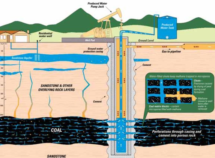
    Hydraulic fracturing, or fracking, is a technique used by the oil and gas industry that blasts water, sand and chemicals into rock formations about 7,000 feet below the earth’s surface to extract oil and natural gas.

    For many people, especially in nearby Longmont and Fort Collins, where fracking was banned by voters and the city council, respectively, the idea of fracking remains threatening.
    Been of Fort Lupton said her cats, which drink her property’s well water, are losing their hair, and her dog is always sick. She said she got her well water tested about a year and a half ago and found high levels of benzene, so she wanted to take advantage of the county’s program to see whether those levels had changed with more drilling in the area.

    Industry officials, including Thom Kerr, permitting manager for the COGCC, say the likelihood of that happening is very low. Benzene is a component of oil, meaning it lies in the same area where oil and gas companies are drilling, about a mile below Been’s waterbed. It would take an extreme force to provide a means for benzene to reach that far, he said. The more likely way that anything would reach Been’s water would be from leaking out of the wellbore, or the actual hole that oil and gas companies drill in the ground. According to the COGCC, operators are required to line the wellbore with several layers of steel and cement casing as far as 50 feet below the base of the deepest aquifer to prevent leaks. Oil and gas operators must also install a layer of production casing after drilling, conduct a pressure test and have the COGCC review the construction design of the well. Those requirements are meant to protect public health and environment in the same way that many other industries are regulated, Kerr said. For example, the wrong mix of chemicals to create steel could be extremely dangerous — and its improper disposal could be even worse.

    “I think that when we start singling out fracking, we think it’s kind of a unique thing, but we have all kinds of industrial processes that, if we were exposed to them or we ate them, they would all kill us,” he said.

    VOCs, BTEX and the EPA: What Weld is testing for

    Out of the 100 samples that Weld County has collected, four have shown extremely low concentrations of the volatile organic compounds, or VOCs, which could be indicative of oil or natural gas, Thomas said.

    VOCs are gases emitted from a variety of sources, including paint, pesticides and cleaning supplies, that could have adverse health effects, according to the Environmental Protection Agency. When scientists are looking for oil and gas activity, they nearly always look for BTEX — benzene, toluene, ethylbenzene and xylenes, which are VOCs that often come from petroleum. At a reporting limit of 0.5 parts per billion for VOCs — that’s a half of a black sugar cube in 1,000 office buildings full of white sugar cubes — it’s impossible to attribute the presence of VOCs in those four samples to any one activity, including oil and gas, Thomas said. What is more, the EPA regulates the presence of BTEX in drinking water at much higher levels. According to the EPA’s list of drinking water contaminants, up to 10,000 parts per billion of xylenes can be present in water before it would be a health risk to consume. Of the BTEX compounds, the EPA most stringently limits benzene, at a maximum of 5 parts per billion in drinking water. That’s still a tenfold increase over the amount that Weld County’s testing program reports.

    Trevor Jiricek, Weld County’s director of public health and environment, said it is important to remember a slew of factors could contribute to the presence of certain chemicals.
    “We are providing this data without knowing what has gone on with that property for the past 100 years,” Jiricek said. Thomas said a plot of property where a number of diesel farm trucks have been stored and driven, for example, could show up in water samples with higher VOCs.
    The gas chromatograph and mass spectrometer is so sensitive, in fact, that it picked up the plastics when new carpet was installed in the county’s public health building, and some chemicals were exaggerated when the parking lot outside of the building was repaved.

    On the road to Fort Lupton, Weld County lab technician Denise Carter said the highly sensitive nature of the water test is why she brings with her three vials of water — one “blank” water sample from the lab to reflect anything that might have altered results on site, plus two samples of water from the house bathroom. “We want the truest sample of what the water is,” Carter said as she donned bright green rubber gloves. Carter said most of the water samples she collects are in south Weld County, probably because residents are closer to oil and gas activity there.

    Those who live in municipalities are sometimes confused when they can’t get their water tested, Carter said. That’s because the testing is open only to residents who are on well water. It’s important to provide the service, though — to pay for a private party to do this kind of test, residents could pay up to $300, Carter said. Most urban dwellers in Weld County get their water from a city or a water district that treats and tests it for the things that the county’s instrument detects. That water typically comes from melted mountain snowpack, or surface water, meaning there is no direct threat to those sources where fracking activities are concerned.

    Contamination

    It can be a concern, however, where oil and gas surface spills are involved, environmentalists say. Bruce Baizel, director of the Oil and Gas Accountability Project, said he is more concerned about spills, such as the 84,000 gallons of fracking flowback water in February that leaked out of a PDC Energy oil well near Windsor, than fracking. Baizel said the number of spills in Colorado and especially Weld County has increased at an alarming rate, and the reporting process for spills is not transparent enough because it is difficult to distinguish in state data how they happened. “It’s the fact that we are still getting each year more contamination issues,” Baizel said, fracking­ related or not.

    Chris Arend, spokesman for Conservation Colorado, echoed Baizel’s comments, saying many environmentalists would also prefer a more comprehensive water testing requirement.
    In January, the COGCC passed a new set of rules, touting the most stringent water testing rules in the nation. In Weld County’s greater Wattenberg area, operators are now required to test one water well every quarter square mile before and after they drill.

    The issue of water contamination from fracking surfaced in the national spotlight with the documentary “Gasland” in 2010, which included several properties in Weld County with high concentrations of methane in their water. The COGCC found a number of inaccuracies and issued a response to the movie, pointing out that methane comes from two sources — bacteria or rocks (scientists distinguish it as biogenic or thermeogenic methane ). To link oil and gas activity to water contamination, the methane would have to come from the rocks where drilling occurs. In “Gasland,” the methane was biogenic, meaning it came from the breakdown of organic material that was naturally present in that area’s aquifers.

    When Weld County detects a higher level of any chemical in a sample, it can often be traced back to organic materials, just like in the case of methane, Thomas said.

    Focus on formulas

    Still, some residents most fear the chemicals used in hydraulic fracturing formulas — substances that neither the county nor the state technically test for. On FracFocus.org, the national database where oil and gas companies disclose the chemicals they use in their fracking formulas (it’s mandatory in Colorado), there are 59 different purposes for the dozens of chemicals most commonly used in fracking. Industry officials and environmentalist alike say the mandatory disclosure on FracFocus.org was a milestone in transparency. To the common reader, the chemicals listed on the site, such as triethanolamine zirconate, lauryl sulfate or guar gum, look a lot like gobbledygook. The details listed alongside each chemical describe their purpose. Methanol, for example, is listed as a corrosion inhibitor, friction reducer, gelling agent and surfactant — more jargon to the common reader, and for some, a reason to fear what is in those formulas.

    Karen Spray, environmental protection specialist for the COGCC, said it doesn’t make sense to test for fracking chemicals. “There is enough variety in what is used out there (in fracking operations), that it would be enormously expensive and time prohibitive to test for everything all the time,” she said. More than that, the testing would not yield any new information, Spray said. She said there are a number of indicators in the state’s regular water testing that would point to the possible presence of fracking­related chemicals. For example, if scientists found chloride in a water sample, it may be potassium chloride, a fluid often used in fracking formulas. In the testing the state does now, scientists would detect the chloride, and that would be a red flag, Spray said.

    Baizel, with the Accountability Project, said from the environmentalist’s side, it’s difficult to even say if frack chemicals are a concern because the disclosure and testing is “kind of a big unknown,” he said.

    Todd Hartman, spokesman for the COGCC, said the chemical disclosure rule was less about dictating what companies use and more about improving transparency and communication with the public. The groundwater testing rules, as well as recent setback rules, were also in response to public concern, he said.

    Kerr said the COGCC does what it can to assuage public fears regarding groundwater and drilling. They hold a number of public meetings and town hall forums, and are continuously working to post as much information as possible to their website. But Kerr said media attention is usually focused on the negative stories.

    Despite the efforts from the COGCC to quell the public’s fears about fracking, Baizel said those fears remain. It is frustrating, he added, to hear government and industry officials downplay their concerns, even though much of the evidence is based on scientific data such as that collected in Weld County’s water testing program. “When you feel like your water might be at risk, or your kids’ health is at risk, those are upsetting things,” he said. “To be told that it’s not a big deal, that does get people upset … The frack issue has really changed the tone of the discussion.”

    More oil and gas coverage here and here.

    The National Weather Service Grand Junction office spring newsletter is hot off the press

    Colorado State University to Host Panel March 13 on Understanding Climate Change, Its National, Regional Impacts

    greenland

    Here’s the release from Colorado State University (Emily Narvaes Wilmsen):

    The Colorado State University School of Global Environmental Sustainability will host a forum titled “Understanding Climate Change and its National and Regional Impacts: The 2013 National Climate Assessment” Wednesday, March 13 as part of its 2013 “Managing the Planet” speaker’s series.

    Leading scientists will provide an overview on climate change and the recently released National Climate Assessment. Each panelist contributed to the 2013 Assessment and will base their discussion on important climate change issues and how this relates to our local situation in Fort Collins. The event will be at Avogadro’s Number, 605 S. Mason, St., Fort Collins, from 5-6:30 p.m. The panel is free and open to the public.

    The panel of speakers includes:

    Dennis Ojima, Ecosystem Science & Sustainability and Natural Resource Ecology Lab
    Shannon McNeeley, North Central Climate Science Center
    Tom Brown, United States Forest Service
    Jill Baron, U.S. Geological Survey and Natural Resource Ecology Lab
    Kathleen Sherman, Anthropology

    The event will be moderated by Gene Kelly, Chair of the Department of Soil and Crop Sciences and SoGES Associate Director for Research and Development. For more information on the speaker’s series, visit http://sustainability.colostate.edu/managing-planet-panel-series.

    Forecast news: Light snow over the mountains today, rest of the week — dry #codrought #cowx

    Snowpack news: Fort Collins watering restrictions begin April 1 #codrought

    snowpackcolorado03112013

    From The Greeley Tribune (Eric Brown):

    This weekend’s storm didn’t live up to its billing as a blizzard, but it was enough to further ease the minds of local farmers, who will begin spring planting soon and were nervous to do so until the recent rounds of moisture wetted their parched soil. During the last week of February and through this past weekend, the Greeley area has received about a foot of snow, according to numbers from the University of Northern Colorado.

    Through Feb. 20, the area had only received about one-third of its average precipitation in 2013, but now, thanks to the recent snowstorms, it’s nearly 30 percent ahead of normal. “It’s definitely enough now to get a crop going,” said Dave Eckhardt, whose family will begin planting onions at the start of April, and then plant corn, sugar beets and dry beans during the following weeks. “Before these last couple snow storms, it was looking a little dicey.”
    Soil moisture is critical in helping seeds germinate after planting.

    Before the recent storms, local farmers didn’t have much to work with. The wetter the soil at planting time, the less supplemental irrigation water is needed right at the start. Eckhardt added that the recent rounds of snow provided a boost to his winter wheat crop, which was planted in the fall and will soon come out its winter dormancy. For months, timely snow and rain had provided just enough moisture to keep alive local winter wheat, a drought-tolerant crop. Farmers had said in early February that moisture would be needed later in the month or in early March to give the crop the moisture it needs to come out its dormancy — and farmers have gotten just that during the last couple weeks, Eckhardt said.

    The recent moisture has also been a boost for ranchers, who need a resurrection of their pasture grass — much of which was depleted during last year’s drought.

    While the soil on the Front Range now seems moist enough for spring planting, more snow is still needed in the mountains, Eckhardt added. Farmers depend heavily on winter and spring snows on higher ground to provide runoff that fills reservoirs and irrigation ditches for the growing season. Many of the crops grown in northern Colorado — onions, sugar beets, corn — need more than the precipitation that falls on the region, so building up snowpack in the mountains each year is critical for farmers in need of supplemental water. However, according to the most recent snowpack figures from the Natural Resources Conservation Service, statewide snowpack was only at about 75 percent of historic average on Friday, and was at its lowest in the South Platte River Basin, sitting at 65 percent of average.

    “We at least have enough moisture here in the ground to work with. That’s a good thing,” Eckhardt said. “If we can just get those two or three decent snowstorms in the mountains, we’ll really start feeling better.”

    From the Fort Collins Coloradoan:

    Concerns over the ongoing drought and its impact on water supplies have prompted Fort Collins officials to implement outdoor watering restrictions effective April 1 with lawn watering limited to two days a week.

    • Even-numbered residential addresses: Thursday and Sunday

    • Odd-numbered addresses: Wednesday and Saturday

    • Commercial/businesses, multi-family and HOAs: Tuesday and Friday

    Restriction do not apply to watering of trees, shrubs, flowers, and vegetables.

    From The Fort Morgan Times (John La Porte):

    Morgan County received up to six inches of blowing, drifting snow from a Saturday snowstorm, and continuing winds made travel difficult in some rural areas of the county Sunday and Monday morning.

    From the Loveland Reporter-Herald (Pamela Dickman):

    In Loveland, utilities staffers have begun to develop a plan to restrict watering based on levels of supply and will take that plan to Loveland City Council at a May 14 study session. “We won’t see anything before June,” said Greg Dewey, engineer with the Loveland utility…

    And even with two recent snows, the amount accumulated in the mountains to feed cities, towns and farmers this summer is well below average. The upper Colorado and South Platte basins, which feed the Colorado-Big Thompson Project, are sitting at 76 percent and 69 percent of average respectively. The numbers increased slightly with the wet snow that fell over the weekend — 2 percent in the Upper Colorado and 3 percent in the South Platte from Friday to Monday.

    Colorado Springs: Mayor Steve Bach is going to ask for an outside consultant for stormwater needs

    pikespeak.jpg

    From The Colorado Springs Gazette (Matt Steiner):

    Mayor Steve Bach announced Sunday night that he’ll seek an outside consultant on Colorado Springs stormwater needs for a second opinion on an issue that’s drawn regional concern…

    A regional stormwater panel has said the city has a backlog of $687 million in stormwater projects, the bulk of the region’s nearly $880 million in stormwater needs. The Stormwater Task Force has backing from El Paso County and smaller municipalities, but the city has been cool to the panel’s findings. Bach has contended that the estimate for Colorado Springs appears high and in January said a second look at the numbers, as well as the scope and proposed priorities of the stormwater work, was needed. “The city’s 78 percent share of the region’s $880 million in needed improvements means that Colorado Springs is by far the largest stakeholder in solving this issue,” the city said in an 8:41 p.m. Sunday news release. “The Mayor has welcomed other regional jurisdictions to use the services of the city’s consultant to also vet their own stormwater needs”

    The city has set a April 5 deadline for bids for the consulting work.

    Sunday night, the city said Bach also wants Colorado Springs to control cash that might be used for stormwater work in the city, rather than putting money in a regional pool for projects.

    More stormwater coverage here and here.

    Forecast news: Two to three inches of snowfall expected west of Fort Collins #codrought

    Forecast news: Light snow possible over northern Colorado today #codrought #cowx

    From the National Weather Service Grand Junction office:

    Mostly sunny skies will prevail for most of the area today with milder temperatures closer to normal. A weak disturbance will move across the north today through Tuesday, generating some light snow showers over the northern Colorado mountains. 3 to 5 inches of snow is expected. High pressure will begin to move in Wednesday and dominate the region through the end of the week, with temperatures warming to above normal levels.

    From the National Weather Service Pueblo office:

    Dry and fair weather is expected across most parts of the region today… with isolated late day snow showers over the central mountains…and occasional high cloudiness across the rest of the travel area. Temperatures are going to the 40s to mid 50s in snow covered areas and the mid 50s to around 60 degrees elsewhere. In the high country…high temperatures will be in the 30s and 40s. For you star gazers out there…Comet Pan-Starrs should be coming into view this week and brightening over the next few days. Watch for it low in the evening sky about 30 minutes after sunset. Use binoculars if you have them to enhance your view.

    San Juans: Just two dust on snow events so far this winter #codrought

    dustonsnowsanjuans.jpg

    From The Telluride Daily Planet (Collin McRann):

    One of the leading local climate research entities in the state is the Silverton Center for Snow and Avalanche Studies, which has been conducting research on local precipitation and snowpack for more than a decade. Over the years, the center has accumulated reams of data about the snowpack, and on Friday a researcher presented some of the center’s findings at the monthly EcoAction Roundtable at the Wilkinson Public Library to a crowd of more than 15 people…

    Though a lot of climate change research is focused on increasing temperatures, there are many side effects of warmer temperatures that could have a profound impact locally. One of those is dust on snow, which the center has been studying for years. Since 2004, the center has been gathering data on the amount of sunlight radiation reflected from the snowpack at sites in Beck Basin. When the snow is clean it reflects more heat and melts slower, but when covered in dust it melts faster. [Researcher Kim Buck] said almost all of the dust on snow in Colorado comes off of the Colorado Plateau. She said once the dust blows in and gets on the snow, it can speed up the melt dramatically — by an entire month in the spring…

    Locally, there have been two dust blow-ins this winter, but they were mild compared with dust storms of the past few years, notably 2009, Buck said…

    The center’s and NOAA’s snowpack data shows that this year’s snowpack is lower than last year at this time. According to NOAA information, the snowpack in the San Miguel, Dolores, Animas and San Juan River Basin is around 85 percent of normal. Last year it was slightly higher. Buck said it could be bad news this summer.

    “It is extremely unlikely that we’re going to catch up on precipitation,” Buck said “Last year the state was just coming off of that great big water year, so reservoirs were full. This year reservoirs are low and then we’re getting another low snow year back to back. So I think the cities in the Front Range will have a pretty hard time in the summer.”

    Snowpack news: The Upper Rio Grande River Basin is at 76% of normal #codrought

    riogranderiverstateengineersoffice.jpg

    Here’s a report about the current snowpack and how the Upper Rio Grande Basin is drying over time, from Ruth Heide writing for the Valley Courier. You numbers junkies will want to click through for all the detail. Here’s an excerpt:

    Dry may be the new normal for the San Luis Valley. “We are having to adjust to a new normal,” Rio Grande Water Users Association Attorney Bill Paddock said during the water users’ annual meeting this week in Monte Vista, “not of the ‘80’s and ‘90’s but of the 2000’s when there is fundamentally less water. We don’t know when this will change.”[…]

    Colorado Division of Water Resources Division 3 Engineer Craig Cotten said the initial projection for the annual index supply for the Rio Grande this year is 435,000 acre feet, currently estimated to be a little more than last year’s 407,000 acre feet. The 407,000 acre feet last year was about 66 percent of average for the Rio Grande, “definitely not a real good year,” Cotten said.

    The 435,000 acre-foot estimate takes into account the NRCS (Natural Resources Conservation Service) irrigation season forecast (April-September) of 360,000 acre feet.

    Of the estimated annual index of 435,000 acre feet, the Rio Grande will have to deliver about 25 percent or about 107,800 acre feet downstream to New Mexico and Texas to meet Rio Grande Compact obligations. Because of winter flows sent downriver prior to the irrigation season and expected to be delivered after it ends this fall, the curtailment on the river during the irrigation season will likely be about 12 percent, Cotten told Rio Grande Water Users Association members on Tuesday…

    Cotten reported the snowpack on the Upper Rio Grande Basin as of March 5 was about 78 percent of normal. “Currently we are a fair amount lower than we should be, than the average, lower than we have been the last three years,” he said.

    He said to reach average snowpack would require 189 percent moisture from now on.

    More Rio Grande River Basin coverage here.

    Anvil Points: Oil shale research facility cleanup completed

    anvilpoints.jpg

    From The Grand Junction Daily Sentinel (Dennis Webb) via The Denver Post:

    High up the Roan Plateau above the 365-acre research site, four gaping mine portals large enough that big trucks once drove through them have been closed off to all but bats. The portals tapped mines that were sometimes 1,000 feet long or more, employed hundreds of miners at their peak and provided 400,000 cubic yards of oil shale that underwent retort heating processes at the research site…

    Congress transferred the research site and the oil shale reserves to the Bureau of Land Management in 1997, and provided that cleanup of the site would be paid for by federal revenues from nearby oil and gas development. “There were huge waste piles of retorted oil shale that didn’t pose an immediate hazard but still needed to be cleaned up,” said John Beck, who is branch chief for lands and realty for the Colorado state office of the Bureau of Land Management, and oversaw the $24 million cleanup project.

    “I think they did a very good job with the (cleanup) work over there,” Cooley said.
    He said he didn’t think the site posed much of an environmental concern. But still, “I think it did need to be cleaned up and put to bed, so to speak, from an aesthetic standpoint if nothing else,” he said.

    For the BLM, part of the problem was that waste shale had been dumped in an adjacent valley that’s home to the intermittent West Sharrard Creek, a tributary of the Colorado River, raising concern about the potential for contamination from runoff. Carla DeYoung, a BLM ecologist who was an inspector for the project, said arsenic levels in the waste measured six times background levels in the area.

    In addition, a fire of undetermined origin in a waste pile created a lot of ash that had to be shipped to a landfill in Denver. The fire also drew oil out of the shale and it accumulated at the base of the waste pile. Petroleum-contaminated material was shipped to C B Industries Delta, a Delta facility where it could be spread out and “land-farmed,” a process under which bacteria can consume the petroleum.

    The sheer volume of waste also proved daunting. The BLM planned on building one waste repository but ran out of room and had to build a second, smaller one nearby, and eventually an even smaller third one…

    The repositories include geomembrane liners at the bottom and 30-inch-thick clay caps on top, covered by reseeded topsoil. Other aspects of the cleanup included demolition and site restoration work involving a former water treatment plant near the river that supplied Anvil Points, and closing off of the mine entrances, which are highly unstable because of the loose surrounding shale.

    More oil shale coverage here and here.

    Ridgway Reservoir: Tri-State hopes to start on the hydropower generation facilities in June

    ridgwaydamusbr.jpg

    From The Watch (Peter Shelton):

    On the heels of a new Draft Supplemental Environmental Assessment released Feb. 25 by the Bureau of Reclamation, Mike Berry came before the Ouray Board of County Commissioners Tuesday with an update. Berry is general manager of Tri-County Water Conservancy District, which manages the dam and is building the power-generating facility at the base of the dam. Power wholesaler Tri-State Generation and Transmission will receive its permit to begin construction of the interconnection station and transmission lines when BuRec’s final EA is approved. Berry reported that Tri-State hopes to begin construction in June and finish the substation by November or December of this year.

    “We hope to have the small generator up and running for this next winter,” Berry told the board. “It should be ready for Aspen’s PPA [Power Purchase Agreement].” The City of Aspen has contracted to purchase the wintertime output from the dam over 20 years. Tri-State, the wholesale electric supplier for San Miguel Power Association and the Delta-Montrose Electric Association, has agreed to purchase, for 10 years, the higher summertime output.

    “Aspen probably won’t see any of those actual electrons,” Berry said. “They will most likely go to [the City of] Delta, which shares the same wholesaler, an outfit with the acronym MEAN out of Nebraska.”

    Tri-County WCD is installing two generators, a smaller 800kV one that should run efficiently on the low, 30-60 cubic-feet-per-second flows in winter, and a bigger 7.2 megawatt one to run on summertime release levels. Together, they will provide enough juice to run 2,000 homes and take the equivalent, in greenhouse gases, of more than 4,000 cars off the road. The big generator should be ready for testing by April 2014, Berry said.

    More hydroelectric coverage here and here.

    Snowpack news: Monarch Mountain nets four feet of snow in four days, latest storm not included #codrought

    snowpackcolorado03082013

    From The Pueblo Chieftain (Tracy Harmon):

    February ended with a flurry of powder at Monarch Mountain where 4 feet of snow fell in four days and readied the slopes for March Madness. Snowfall at Monarch continues to be plentiful with 16 inches of new snow falling in the first two days of this week. The resort boasts a 65-inch base and has had a total of 230 inches of snowfall — the equivalent of 19 feet — so far this season.

    Snow totals from the National Weather Service Boulder office.

    Kerber Creek restoration project update: 4,000 feet of stream bank restored

    kerbercreekproject.jpg

    From the Valley Courier (Trevor Klein):

    Today, the Kerber Creek Restoration Project unites 16 partners in the effort to restore the Kerber Creek watershed, including the BLM; USFS; U.S. Fish and Wildlife Service; Natural Resources Conservation Service; Trout Unlimited; CDPHE; the Rio Grande Watershed Conservation and Education Initiative; and the Bonanza Stakeholders’ Group, which represents the interests of Kerber Creek watershed private landowners. Since 2008, the Office of Surface Mining’s Western Hardrock Watershed Team/AmeriCorps Volunteer in Service to America Program (OSM/VISTA) has provided a full-time staff member to serve as the project’s watershed coordinator.

    This partnership has allowed the project to treat more than 60 acres of mine waste deposits, to restore more than 4,000 feet of stream bank, and to raise more than $2 million in grant funding. The project has also enhanced the aquatic ecosystem of the main stem of Kerber Creek, encouraging the brook trout population that returned as a result of the 1990s cleanup efforts and even attracting brown trout from San Luis Creek, into which Kerber Creek ultimately flows. Furthermore, the partnership has helped to ensure that these improvements remain protected by beginning the process to acquire minimum in-stream flow rights for almost the entire length of Kerber Creek and two of its major tributaries. In recognition of these impressive achievements, the Kerber Creek Restoration Project has received six major awards at the regional, state, and national levels.

    These accomplishments could not have been achieved without the help of numerous volunteers, who have contributed more than 13,000 hours to the project over the past six years. Brady and Jane Farrell, heavily involved members of the Bonanza Stakeholders Group, summarized their experience with the project in October, 2011:

    “All in all, we believe this project has been a success in every way. We owe a huge debt of thanks to this project, its staff and to the members and volunteers of the various agencies that have worked with us to clean up and improve Kerber Creek… We feel lucky to be part of the Kerber Creek Stakeholders group.”

    While the restoration of the Kerber Creek watershed is far from over, the project serves as a reminder of the importance of collaboration, persistence, and patience to the conservation and preservation of Colorado’s water resources. Over the past six years, the Kerber Creek Restoration Project has attempted to narrow the gap between an ecosystem degraded by the environmental effects of human activities and an ecosystem created and sustained by natural processes. Though the methods may differ, the principles remain the same; strong, lasting partnerships, the involvement of all interested stakeholders, and data-driven initiatives are required to ensure that Colorado’s water resources are protected for present and future generations.

    More Upper Rio Grande River Basin coverage here and here.

    Pitkin County is opposing the diligence claim for two dams in the Crystal River watershed as speculative

    crystalvoicepetemcbride.jpg

    Here’s an in-depth report from Brent Gardner-Smith writing for Aspen Journalism. Click through and read the whole article. Here’s an excerpt:

    Pitkin County wants a water court judge to rule that the planning period for a project that includes a dam on the upper Crystal River, and one on North Thompson Creek in the Thompson-Divide area, has lapsed since planning began in the late 1950s. The West Divide “conditional water rights continue to be water rights in search of a project,” the county told the court in its Feb. 22 motion. “The project is no closer to being funded and built in 2013 than it was in 1957” and the project remains “speculative,” according to the motion.

    The county’s motion was filed in Division 5 water court in Glenwood Springs. Judge James Boyd is overseeing the case, which is set for trial in August. The county and other groups are opposing a diligence filing on the conditional water rights for the West Divide project held by the Colorado River District and the West Divide Water Conservancy District. The rights date to 1958.

    More Crystal River Watershed coverage here and here.

    Avon: Denver Water’s Bill Bates to discuss the relationship between water users on the Front Range and the Western Slope, March 11

    coloradotransmountaindiversions.jpg

    From email from the Eagle River Watershed Council:

    The Watershed Council would like to invite you to join us for the fourth and final H2Know High Country Speaker Series!

    We will welcome Bill Bates of Denver Water to discuss the relationship between water users on the Front Range and the Western Slope. Mr. Bates currently oversees the protection and development of water rights associated with Denver Water’s collection system. Prior to this, Bill supervised the water supply operations and reporting for the Denver Water collection system.

    This High Country Speaker Series / Water Wise Wednesday is presented by the Eagle River Watershed Council, Walking Mountains Science Center and the Eagle Valley Library District…

    Monday
    March 11th
    5:30-7:00 pm
    Walking Mountains Science Center
    Avon, CO

    More education coverage here.

    The latest monthly briefing from Western Water Assessment is hot off the press #codrought

    klauswolterforecastapril2june2013

    Click here to read the briefing. Click through for the graphics and detail. Here’s an excerpt:

    Highlights

  • February precipitation was mainly below-average for the region, with the driest conditions across Utah; eastern Colorado and central Wyoming saw above-average precipitation.
  • Snowpacks are now below-average in nearly every basin across the region after a dry February caused the snowpacks in Utah and western Wyoming to lose ground compared to average conditions
  • The March 1 spring-summer streamflow forecasts for the region call for well-below-average (<70%) runoff in nearly all basins, reflecting both the low snowpacks and the unusually low soil moisture last fall
  • The NOAA CPC seasonal climate outlooks show a dry “tilt” for spring and early summer precipitation for most of our region, though the one-month outlook for March has no tilt. In contrast, the “SWcast” for April–June shows a wet tilt over Colorado and eastern Utah.
  • Fort Morgan: City Council hopes to score some grant money to study stormwater needs

    fortmorgan.jpg

    From The Fort Morgan Times (Jenni Grubbs):

    The Fort Morgan City Council on Tuesday directed city staff to seek out grants to cover the cost of a study for how to implement a stormwater fee.
    “The recommendation from the (Stormwater) Ad Hoc Committee was to assess a fee to address stormwater issues,” Wells said. But he said that staff were not sure yet what fee would need to be to cover everything it would need to cover, or if that was what the council wanted.

    “If we do this, we want to make sure we do it the right way,” he said, suggesting a study. He said that some Colorado municipalities had put in place stormwater fees without studies, leading to questions from the people paying fees and even ballot issues eliminating the fees…

    The third option, which was the one that was recommended by the committee, would be to create a stormwater utility and assess a monthly fee to city residents. Wells explained that a big issue with this was how the money would be allocated in the budget between a new enterprise fund and where it used to come out of the general fund…

    The council did direct Wells and staff to find out more about the costs of study for stormwater fees, as well as seek grants to pay for that type of study. Wells did say that a stormwater fee study likely would cost between $30,000 to $50,000, but that grants may be available to cover about half of that cost.

    More stormwater coverage here and here.

    Julesburg: Final installment of the state’s Drought Summit webinars series March 19

    julesburg.jpg

    From The Pueblo Chieftain:

    The final installment of the state’s Drought Summit webinars series will take place from 11 a.m. to 1 p.m. March 19 from Julesburg.

    The Internet seminar will focus on range management issues and management considerations for livestock producers. A Colorado State University pest management specialist will discuss grasshoppers.

    For more information, call 970-345-2287.

    Colorado lifts storage restriction at Cucharas Reservoir

    cucharasreservoirchieftain.jpg

    From DailyMarkets.com:

    Two Rivers Water & Farming Company (www.2riverswater.com) announced today the storage restriction on the Cucharas Reservoir has been removed. The storage restriction had been on the Reservoir since July 1988. Two Rivers Water and Farming Company was able to complete the restoration with a loan from the Colorado Water Conservation Board. Removal of the restriction is the first step in fulfilling the Colorado State Engineers Dam Safety Office compliance plan for the Reservoir. The restored reservoir can now hold up to 10,000 AF of water. Two Rivers expects to completely rebuild the reservoir in the near future and restore its full storage capacity. The Cucharas Reservoir has an absolute right to store 31,956 AF of water and a conditional right to store 34,404 AF when rebuilt.

    Two Rivers currently has the right to store in excess of 70,000 AF in four separate reservoirs and is in the process of developing as much as 25,000 AF of additional storage capacity on the Arkansas River. The storage is part of a rotational farm-fallowing program being developed by Two Rivers to expand its vegetable farm production and more efficiently use water amongst water users in Pueblo County, Colorado. Two Rivers is currently in discussions with Pueblo Board of Water Works and Colorado Springs Utilities, as representatives of the Recovery of Yield Group, whereby the parties would collaboratively develop reservoir space and develop lease agreements to permit the use of return flows for irrigation and augmentation purposes.

    More infrastructure coverage here.

    Broomfield: Discussion of irrigation techniques and sprinkler systems Saturday

    broomfield.jpg

    From the Broomfield Enterprise (Mike McNulty):

    The beauty of the Rocky Mountains is undeniable, especially when viewed from the plains. Unfortunately, these beautiful mountains create a rain shadow effect that limits the amount of precipitation the Front Range receives. Last year was a dry year, and despite the recent round of snows, this year could be another. We are already behind in moisture when compared to normal, and there is a possibility that some form of water restriction will be implemented this growing season.

    The Colorado Water Institute, an affiliate of Colorado State University, estimates that more than 50 percent of residential water consumption is used for landscape irrigation. With good water conservation practices and efficient use of this precious commodity, homeowners can drastically reduce this percentage while sustaining gardens and turf…

    As part of the Gardening Recycling Energy Environment Nature Program Series presented by Broomfield’s Parks and Environmental Services departments, a discussion of irrigation techniques and sprinkler systems will be at 9 a.m. Saturday at the Broomfield Recycling Center, 225 Commerce St. The program is free.

    More water conservation tips can be found at ext.colostate.edu/drought/eff_landscape.html.

    .

    More conservation coverage here.