Forecast news: Big wet snowflakes falling this morning at Gulch Manor #codrought #cowx

A beautiful snowfall this morning outside the windows here at Gulch Manor. I’m doing my celebration dance.

From the Fort Collins Coloradoan (Bobby Magill):

Fort Collins, which is under a winter storm warning through 5 p.m. Saturday, will see between 4 and 10 inches of snow before the storm clears the area, said meteorologist Judy Fossum of DayWeather in Cheyenne. High winds reaching 30 mph Saturday afternoon could blow some of the snow away. A blizzard warning is in effect for areas of southeast Wyoming…

That’s great news for the mountain snowpack, which is 66 percent of normal in the South Platte River Basin, which includes the Poudre River and Poudre Canyon, where more than a foot of snow is expected.

Snowpack news: Gunnison Basin 73% of normal, Taylor Park Reservoir not expected to fill #codrought

snowpackcolorado03082013

gunnisonbasinhilow030820132

Click on the thumbnail graphics for the Gunnison Basin High/Low graph and the statewide snowpack map from the Natural Resources Conservation Service.

From Crested Butte News (Alissa Johnson):

Conditions are getting more than a little bit dry in the Gunnison Basin—snow water content in local snowpacks is measuring between 63 percent and 65 percent of normal, and that has water experts taking measures to make sure there’s enough water in the basin to cover spring irrigation needs.

“The recent snowfall caused a measureable increase to our snowpack, but the bad news is we’re still well behind average snowpack levels for this date,” said Frank Kugel, general manager for the Upper Gunnison River Water Conservancy District (the district). He said that the three SNOTEL units above Taylor Park Reservoir show a snowpack at 63 percent of normal. Down at Blue Mesa, things aren’t much better, with the snowpack measuring 65 percent of normal. To put that into perspective, Kugel explained that winter releases out of Taylor Reservoir have been set at the very minimum level, 50 cubic feet per second, and water levels have not increased…

Locally, the city of Gunnison has approached the district with a willingness to turn on the city’s ditch system as much as ten days to two weeks late. The district itself is looking to purchase water out of the Aspinall or Ridgway Reservoirs in order to fulfill a call on the Gunnison Tunnel and keep water in the valley in April and May for critical irrigation, an unusual step for the district to take. But this is also an unusual year. Not only are things looking worse than last year, but conditions are compounded by two low snow years in a row.

“We’re currently below last year’s snowpack for this date,” said Kugel. He added that things are “dramatically worse for water supply because we drew on the reservoirs throughout the summer last year and now they’re not likely to fill.” Taylor Reservoir is projected to, at best, hit about 80 percent of normal unless the late-season snows continue. The hope we all have now is for snow. As long as it keeps snowing, it seems, the situation will be a lot less grim.

From the Vail Daily (Randy Wyrick):

The Colorado River Basin — that’s us — has 86 percent of last year’s snowpack and 70 percent of the historic normal, the NRCS said. The statewide snowpack is 73 percent of average.

“The snow this year has arrived with great timing for conditions on the hill,” said Diane Johnson from the Eagle River Water and Sanitation District. “From a water supply perspective, if current conditions continue, it’s setting up to be a more difficult summer than 2012, unless we get a bunch of summer storms.” Eagle County is still in “extreme” drought, Johnson said.

A warm and dry March could also mean trouble for this summer’s water storage. In the Colorado River Basin, reservoir storage is 66 percent of average and 57 percent of last year’s record levels…

Streamflow forecasts point to below-normal volumes for this spring and summer in all Colorado’s major river basins. Statewide, reservoirs are 71 percent as full as they usually are, the NRCS said…

In the combined San Miguel, Dolores, Animas and San Juan basins, the snowpack dropped 5 percent as of March 1. The South Platte basin, which provides water to much of Colorado’s Front Range, is 63 percent of average…

“The core of warmth for the spring is going to center itself in the dry areas, the western plains, east-central Rockies, maybe extending down into the Southwest mid- to late-season,” said Paul Pastelok, a long range forecaster with Accuweather. “Unfortunately for the western plains and eastern Rockies, I think the drought is going to persist, and it is going to be strong going into the springtime.

From Steamboat Today (Tom Ross):

Time is growing short if the snowpack — water content in the standing snow — surrounding Steamboat is to its historic norm by the end of the season, Mage Hultstrand, of the Natural Resources Conservation Service in Denver, said Thursday. She said February and March typically combine to provide 36 percent of annual snowpack, with April contributing another 3 percent. With current snowpack in the combined Yampa/White River basin standing at 47 percent of the annual peak, mountains in the area would have to see 53 percent of the annual snowpack accumulate between now and the second week in April to reach the average…

The NRCS reported Feb. 1 that despite heavy snowfall in late January, Colorado’s snowpack was at 72 percent of normal for the date and 10 percent lower than where it stood at the same time in the drought winter of 2011-12.

The combined Yampa/White river basin, which includes most of Routt County, is doing a little better, according to the NRCS, at 77 percent of average and 115 percent of last year’s levels. Another encouraging sign is that reservoir storage across the twin basin currently stands at 103 percent of average for the date.

Focusing on specific locations in the Yampa River Basin, the snow measuring station at 9,400 feet on the west side of Rabbit Ears Pass was showing 11 inches of water contained in 43 inches of snow Thursday, or 75 percent of average for the date. Those 11 inches of water also represent 42 percent of peak snowpack (water content); Rabbit Ears typically peaks at 26.1 inches of moisture April 28.

At the Tower site at 10,500 feet on Buffalo Pass, there currently is 69 inches of snow on the ground containing 19.2 inches of moisture. The water content at the Tower site, which typically holds some of the most robust snowpack in the state, is just 66 percent of the average of 29.1 inches for the date and 37 percent of the seasonal peak. The Tower site peaks, on average, at 51.4 inches of water May 9…

“Any area can have crazy storms in late season,” Hultstrand said, “But usually by then the snow is so ripe, it’s already running off. So even though you’re accumulating more snow, you’ve already reached peak.”

From the Sky-Hi Daily News:

Present snowpack levels are lower than last year at this time. March and April are typically the wettest months of the season…

Snowpack in the high elevation mountains above Middle Park now ranges from 59- 94 percent of the 30-year average, with the overall average for Middle Park at 75 percent. Last year at this time the same area was at 81 percent of average. Snow density is averaging 22 percent, which means that for 1 foot of snow there is only 2.6 inches of water. “This is pretty low snow density for this time of year,” [snow surveyor Mark Volt of the USDA Natural Resources Conservation Service Kremmling Field Office] said. “Snow density for March 1 usually runs in the high 20s. Snow stability remains weak.”

From Steamboat Today (Tom Ross):

Stagecoach Reservoir east of Oak Creek has a chance to fill this summer, and Elkhead Reservoir outside Craig and Fish Creek Reservoir on the Continental Divide northeast of Steamboat Springs are expected to top out in spite of the persistent drought conditions. However, Yamcolo Reservoir near the headwaters of the Yampa River upstream from the town of Yampa is a bigger question mark…

Rossi said Yamcolo, with a capacity of 9,000 acre-feet of water, was tapped early by irrigators in the summer of 2012, when every drop of the reservoir’s water committed to agriculture was used. The recently expanded Stagecoach leased some water to the Colorado Water Conservation Board last summer, which drew it down farther than it might have been. The reservoir gradually has been gaining ground since September 2012…

The ability of Stagecoach to fill could depend upon how early the irrigation season begins this summer, he added. About 55 miles farther down the Yampa River system, Elkhead Reservoir can be expected to fill, said Ray Tenney, a water engineer with the Colorado River Water Conservation District…

Jay Gallagher, manager of the Mount Werner Water and Sanitation District in Steamboat Springs, told the Steamboat Today on Wednesday that although Fish Creek Reservoir currently is less than 40 percent full, the 26.7 inches of water currently stored in the snowpack on Buffalo Pass is sufficient to fill the city of Steamboat Springs’ primary water supply this season.

From The Wet Mountain Tribune (Nora Drenner):

As of Wednesday, March 6, the snow depth at the South Colony SNOTEL site was at 13.1 inches as compared to 1.4 inches in November 2012, 3.6 inches in December 2012, 7.2 inches in January and 9.8 inches in February. There was 46 inches of snow at the site in March 2012. The site’s readings currently stand at 46 percent of long-term average while the entire Arkansas River basin is at 53 percent of long-term average.

Additionally, the snow/water equivalent right now at South Colony is 10.10 inches as compared to zero in November 2012, 1.90 inches in December 2012, 5.10 inches in January and 7.20 inches in February. There was 13.2 inches of snow/water equivalent in March 2012…

“Moisture is always a good thing” said Valley rancher Sara Shields.

Dick Wolfe hopes that the Rio Grande Decision Support System will be ready next month

slvdischargerecharge.jpg

From the Valley Courier (Ruth Heide):

Wolfe said the computer groundwater model, the Rio Grande Decision Support System, is still being updated, and the new target date for that model to be ready to go is April. The San Luis Valley’s first water management sub-district depended on the model calibrations to determine how much it owed senior surface water rights, and future sub-districts will depend on the model for those numbers as well.

Wolfe said he wanted to make sure the model could be used to accurately determine the amount of depletions each sub-district needed to replace to surface water rights before moving forward with the rules.

“We want to make sure it’s done right,” Wolfe said.

He added he would like the model to be ready in April, but if it still needs work, he would rather wait than use incomplete information.

“We have a lot of hours, man hours, and people working on getting the task accomplished,” he said.

“I am optimistic we are getting closer to final numbers.”[…]

Rio Grande Water Conservation District General Manager Steve Vandiver said the model could have been completed more quickly if those working on it had not had to take time for court hearings and trials over the sub-district. Vandiver said after the first sub-district was approved in 2006, two lawsuits were filed that bound up resources including engineers, modelers and attorneys. They have had to prepare for three major trials and a Supreme Court decision. Those legal challenges were the reason the model has not been completed more quickly, Vandiver said…

As soon as the model is satisfactorily updated, the groundwater rules advisory committee will begin meeting again, Wolfe said. This group is now in its third year of working on the regulations, he added. Two pieces of the regulations still need to be finalized, the phase-in portion and the sustainability portion, Wolfe said. The phase-in portion lets each sub-district get a plan of water management approved by the court and an annual operating plan in place. The sustainability portion was difficult, Wolfe said, because the group had to determine how to measure sustainability.

Once the rules are completed, they will be submitted to the water court for final adoption, Wolfe said. If the rules are opposed, they will go through an appeal process, so the effective date of the rule implementation would depend on how quickly and smoothly that process went.

More San Luis Valley Groundwater coverage here and here.

CMU: River Crossings Conference will highlight emerging issues in riparian restoration and river management

tamarisk.jpg

Click here for the inside skinny from Colorado Mesa University. It sounds like a terrific program. Here’s an excerpt from the website:

River Crossings: Linking River Communities is an interagency river management workshop and research conference presented by the Bureau of Land Management, River Management Society, Tamarisk Coalition, The Water Center at Colorado Mesa University, and International Submerged Lands Management Conference. We are joining together to host a week of presentations, panels and field trips highlighting recent advances and emerging issues in riparian restoration and river management practices.

This event will provide a unique interdisciplinary training opportunity where researchers, students, agency managers and practitioners will present and discuss scientific advances and program learning. Attendees will be able to network with agency and other professionals, and bridge the gap between research and land management.We look forward to seeing you in March!

From the Grand Junction Free Press (Hannah Holm):

Have you noticed tamarisk stands along the Colorado River turning sickly, or just vanishing, turned to stumps? Have you wondered what impact that has on birds and what it takes to reestablish native willows and cottonwoods? Maybe read that some dams up in the Northwest have been removed and wondered how those rivers responded?

You can learn about all this and more as researchers and river managers from around the West descend on the University Center Ballroom at Colorado Mesa University for the River Crossings Conference and Workshop from March 11-15.

The Tamarisk Coalition, River Management Society, Bureau of Land Management, International Submerged Lands Conference and Water Center at CMU are working together to organize the event.

The River Crossings Conference and Workshop will include presentations, panels and field trips highlighting recent advances and emerging issues in riparian restoration and river management practices. Friday field trip options include a float trip down the Ruby-Horsethief Canyon on the Colorado River, a tour of the Colorado Riverfront, a tour to the Palisade Insectary and a tour of restoration projects along the Dolores River near Gateway.

More restoration/reclamation coverage here.

Say hello to the new AWRA Colorado Section website

awracoloradologogolive03082013

Click here to visit the website. Be sure to register for the Annual Symposium.

Forecast news: Significant mountain snowfall starting today #codrought #cowx

From the CoCoRaHS blog:

In the west an upper level system will come ashore in southern California early Friday heading toward the southern Rockies. Rain and snow will accompany this system as it makes its way across the Southwest, and winter weather advisories, watches, and warnings are in effect for a number of western states. This southern system will merge with another disturbance in the Northern Plains, and by Saturday morning will be bringing snow to a large portion of the central and southern Rockies and the Northern Plains. Ahead of this system, strong southerly winds will feed moisture to fuel showers and thunderstorms eastward through the Midwest.

From The Denver Post (Nic Turiciano):

Areas along the Front Range — Denver included — can expect from 6 to 10 inches of snow between Friday night and the early evening of Saturday. New forecasts from the National Weather Service also call for snowfall in the northern mountains and foothills to total between 8 and 16 inches…

Flurries will begin Friday afternoon in the mountains with snow falling in the metro area by Friday evening. Winds from 20 to 35 mph will create low visibility for Denver and the plains. Much of central and northeastern Colorado will remain in a Winter Weather Watch through Saturday evening.

Reclamation to start pumping to Carter Lake on Monday

More Colorado-Big Thompson Project coverage here.

Cache la Poudre River: Less CBT irrigation water due to High Park Fire pollution #codrought

strawdroppedbyhelicoptersoldiercanyonhighparkfire.jpg

From The Denver Post (Bruce Finley): via the Loveland Reporter-Herald:

The scorching of Colorado forests by super-intense wildfires is worsening the water woes for Eldon Ackerman and other Larimer County farmers, jeopardizing thousands of irrigated acres that normally produce millions of dollars in crops. The problem: soot, sediment and debris washing from burned forests have made the Cache la Poudre River less reliable as Fort Collins’ main water supply for urban households. Particles clog treatment facilities. So, city officials say, they must heavily tap their secondary supply — water piped under mountains from the Western Slope. That water typically has been leased to farmers.

Fort Collins officials recently notified 80 farmers not to expect any leased water this spring. And suddenly, Ackerman — instead of ordering seeds and fertilizer — is talking with insurers and preparing to lay off hired hands…

In the big picture, this intensifying water crunch reflects a shifting balance of power between cities and the agriculture that traditionally has anchored life along Colorado’s northern Front Range. Drought and the oil-and-gas industry’s appetite for drilling water already have weakened farmers’ position. Cities in recent years have purchased interests in irrigation-ditch companies. Farmers have sold their water rights, taking advantage of high prices. Financial stress and low commodity prices forced some to sell. Others simply sought profit. The result is that city interests increasingly dominate decision-making. “Now, cities are getting very conservative because of the drought, compounded with the wildfire,” said Reagan Waskom, director of Colorado State University’s Water Center…

“We’ve got this twofold issue of drought complicated by fire, and the issue of more fires. What that will do to our water yields is very unknown,” said John Stulp, a Colorado agriculture leader serving as a special water adviser to Gov. John Hickenlooper.

More water pollution coverage here.

Drought news: The next CWCB Water Availability Task Force meeting is March 21, there won’t be a dry eye in the place #codrought

mallardducktakingflight.jpg

From email from the Colorado Water Conservation Board (Ben Wade):

A Joint Water Availability & Flood Task Force meeting is scheduled for Thursday, March 21 from 9:30a-12noon & will be held at the Colorado Parks & Wildlife Headquarters, 6060 Broadway, Denver in the Bighorn Room.

More CWCB coverage here.

The latest El Niño/Southern Oscillation (ENSO) Diagnostic Discussion is hot off the press

elninolanina.jpg

Click here to read the latest discussion. Here’s an excerpt:

During February 2013, ENSO-neutral continued although SSTs remained below average across the eastern half of the equatorial Pacific Ocean. The Niño 3.4 index remained near -0.5°C, while the Niño 3 index became less negative as the month progressed. The oceanic heat content (average temperature in the upper 300m of the ocean) similarly increased during the month, largely due to the eastward push of above-average temperatures at depth. The Madden-Julian Oscillation (MJO) again contributed to increased atmospheric variability over the tropical Pacific during February. Anomalous low-level winds were primarily easterly over the west-central equatorial Pacific, while upper-level winds remained near average, but with some intra-monthly variability. Over Indonesia, anomalous convection remained enhanced north of the equator and suppressed south of the equator. Due to the lack of persistent atmosphere-ocean coupling, the tropical Pacific continues to reflect ENSO-neutral.

NOAA: The National Climatic Data Center ‘National Overview – January 2013’ is hot off the press

coloradoriveraboveshadowmountain.jpg

Click on the thumbnail graphic for January’s significant events. Click here to go to NOAA’s State of the Climate page. Here’s an excerpt:

Climate Highlights — January

  • The average temperature for the contiguous U.S. during January was 32.0°F, 1.6°F above the 20th century average, tying with 1958 as the 39th warmest January on record.
  • January brought warmer-than-average conditions to the eastern half of the contiguous U.S., despite several cold air outbreaks. The largest warm temperature departures from average were in the Southeast, where Georgia and Florida both had their 11th warmest January with monthly temperatures 5.7°F and 5.6°F above average, respectively.
  • Below-average temperatures were anchored in the western United States. Nevada had its ninth coolest January on record, with a monthly temperature 5.9°F below average, and Utah had its eighth coolest January, with temperatures 7.5°F below average.
  • The January nationally-averaged precipitation total of 2.36 inches was 0.14 inch above the long-term average. The January precipitation average masked both wet and dry extremes across the nation. Drought conditions remained entrenched across the Southeast, Great Plains, and the mountainous West.
  • Wetter-than-average conditions stretched from the Southern Plains to the Mid-Atlantic, where Louisiana, Mississippi, Tennessee, Michigan, and Virginia each had January precipitation totals ranking among their ten wettest. The above-average precipitation generally missed the core drought areas of the central and southeastern United States.
  • Drier-than-average conditions were observed along the West Coast, the central Rockies, and parts of the Northern Plains, Southeast, and Northeast. California, Connecticut, and Florida each had one of their ten driest Januarys.
  • According to data from the Rutgers Global Snow Lab, the January snow cover extent for the contiguous U.S. was slightly above average at 1.4 million square miles. Mountain snowpack was near-average for much of the West, with the exceptions in parts of the Northwest where snowpack was much above average, and in the Central and Southern Rockies where snowpack was much below average.
  • Alaska was warmer and wetter than average. The statewide average temperature was 7.1°F above average and the precipitation total was 64 percent above average. Parts of the state had monthly temperatures more than 10°F above normal.
  • According to the January 29th U.S. Drought Monitor report, 57.7 percent of the contiguous U.S. was experiencing moderate-to-exceptional drought, smaller than the 61.1 percent at the beginning of the month. Drought conditions improved in parts of the Mid-Atlantic and Mid-Mississippi River Valley.
  • Forecast news: Models show the weekend storm tracking north of I-70 #codrought #cowx

    Snowpack news: Upper Colorado River snowpack = 75% of normal, South Platte = 67% (worst in state) #codrought

    snowpackcolorado03062013

    From The Grand Junction Daily Sentinel (Dennis Webb):

    With time running out to play catch-up, Colorado’s snowpack remains well below average, increasing only nominally last month, the Natural Resources Conservation Service said Tuesday. Storm systems boosted the state average to 73 percent of normal on March 1, compared to 71 percent as of Jan. 1 and Feb. 1. But it was just 83 percent of the level at this time during the dry winter of 2011-12.

    “The most recent streamflow forecasts continue to point towards well below normal volumes for this spring and summer in all the major river basins in Colorado. Reservoir storage across the state remains well below average, at just 71 percent of average as of March 1” and 67 percent of the same time a year ago, the NRCS added in a news release.

    Reservoir levels generally were much higher a year ago but storage was drawn down because of the poor snowpack a year ago.

    “Unless Colorado sees weather patterns in March that bring well above average snowfall and precipitation to the state, there will not be much relief from the current drought conditions,” the agency said. February storms benefited most basins in the state, but not all, it said.

    The combined San Miguel, Dolores, Animas and San Juan basins’ March 1 snowpack was 83 percent, compared to 88 percent a month earlier. The South Platte Basin showed the largest increase, hitting 63 percent of normal, up from 54 percent a month earlier. The Colorado Basin is at 70 percent of normal and 86 percent of the same time a year ago. For the Gunnison, those figures are 74 and 87 percent, respectively. The Yampa/White is at 76 percent of average; the Rio Grande, 79 percent; and the Arkansas, 71 percent.

    Reservoir storage levels range from just 53 percent of average in the Rio Grande Basin to 106 percent for the Yampa/White.

    From Steamboat Today (Tom Ross):

    More than 150 people, many of them farmers and ranchers faced with the possibility a second straight season of extreme drought, squeezed into the Steamboat Springs Community Center on Tuesday night to learn how to get along in a new era of limited water for irrigating hay and watering stock.

    Division 6 water engineer Erin Light told the gathering it could be worse. “We really are fortunate up here in the Yampa Basin that we really have had the water we’ve needed,” Light said. “We’re just now beginning to see the beginning of administration” on the rivers and their tributaries…

    Andy Rossi, of the Upper Yampa Water Conservancy District, said his agency had put together a mini-grant program that could offer a 50 percent cost share and pay as much as $500 per structure for installation of adequate water-measuring devices. Learn more at http://www.upperyampawater.com.

    And Light said she is working with Colorado Parks and Wildlife and the Upper Yampa District to tap into Parks and Wildlife water stores in Steamboat Lake reservoir specifically to be able to offer water augmentation plans to irrigators. It would offer some the ability to use more water than they otherwise would be entitled to by contracting with Upper Yampa District to release some of the augmentation water on its way to the thirsty Elk. Her office can be reached at 970-879-0272.

    From The Greeley Tribune:

    February finally brought cool and wet weather to Greeley after months of warm and dry, and 2013 is now above average for moisture. Precipitation in February amounted to 0.99 inches, which is 0.59 inches above average, and snowfall piled up to 8.9 inches, 4.5 inches above normal…

    Through the first two months of 2013, precipitation amounted to 1.07 inches, 0.19 inches above normal and standing as the 15th-wettest year on record so far. However, for the entire snow season, which goes back to the fall, snowfall is still behind pace.

    Before storms in February, Greeley experienced little snow this past fall and winter. Seasonal snowfall this year so far is 19.5 inches, which is 7.6 inches below normal, and stands as sixth-least snowy season on record.

    Next Middle Colorado Watershed Partnership meeting March 20 #coriver

    coloradorivereaglecounty.jpg

    From email from the Middle Colorado River Watershed Partnership:

    Our next Partners meeting will be held on Wednesday, March 20th from 8:45 to 11:15 AM at the City of Glenwood Springs wastewater treatment facility. We will be touring the newly constructed plant to see how a modern, state-of-the-art wastewater facility operates, including examining the quality of water that comes in and goes out of the plant, and controls that are in place to protect the quality of discharge released back to the Colorado River. In comparison, we will also look at how small, backyard wastewater treatment systems are designed, what’s important to keep them functioning, and how they have the potential to affect our watershed.

    The facility is located in West Glenwood, west of the exit and on the south side of the Colorado River. From the I-70 exit at West Glenwood, turn right into the roundabout and exit onto Midland heading south. Take the first right-hand turn off of Midland onto Wulfsohn Road. The entrance to the facility is an immediate right-hand turn off of Wulfsohn Road, down a long drive that travels west along the river.

    This meeting is free and open to the public. If you plan to attend, please RSVP by [sending email to midcoriver@gmail.com], so that we can plan accordingly or contact you in the case of a weather cancellation. Hope to see you there!

    More Colorado River Basin coverage here and here.

    The Colorado Water Trust is out of the blocks early this season with their ‘Request for Water’ #codrought

    coloradoriveraboveshadowmountain.jpg

    From email from the Colorado Water Trust:

    Request for Water is a water leasing program that benefits both water users and the environment. A 2003 Colorado state statute enables CWT in collaboration with the Colorado Water Conservation Board (CWCB) to lease water for streams on short notice to protect the environment. This tool for rewatering streams under Colorado’s Instream Flow Program has been available since 2003, but CWT was the first to use the statute to add water to streams during drought conditions in 2012. CWT intends to lease water for environmental benefits again this year; the March 1st snow report indicates that snowpack is again below average. Many rivers and streams may see shortages for a second year in a row and for some in Colorado, the dry spell has been much longer. Request for Water also addresses the financial needs of Colorado’s water users by compensating owners for the temporary use of their water rights. We are excited to offer water users the opportunity to both protect Colorado’s natural heritage and generate revenue—lease your water for instream flow use, receive compensation, and grow a crop of fish habitat.

    Read the case for Request for Water 2013 in its entirety.

    From The Pueblo Chieftain (Chris Woodka):

    The Colorado Water Trust is seeking water rights for short-term lease for environmental benefits during what many expect to be a drought year.

    In 2012, the trust piloted a water leasing program in partnership with the Colorado Water Conservation Board along with other state and federal agencies to negotiate four unprecedented short-term water leases under a 2003 Colorado state statute. There were 94 offers of water rights, which were narrowed down to 13 after an engineering review. Water from six rights were packaged into four leases that provided flows in 190 miles of streams.

    “When we launched the Request for Water 2012 pilot program, asking water users to lease water in a way that had never been tried, we didn’t know exactly what to expect,” said Amy Beatie, executive director of the Colorado Water Trust. “We’re starting earlier this year.”

    “The CWCB is looking forward to partnering on short-term leases with the trust and water users this year,” said Linda Bassi, chief of the CWCB’s stream and lake protection section. “The leased water provides significant benefits to Colorado’s streams and the public.”

    The water trust is working with basin roundtables, water districts, land trusts, and other entities and organizations to schedule presentations about the program.

    More instream flow coverage here.

    Two Rivers Water and Farming Company sees a bright future for agriculture

    irrigatedagriculture.jpg

    From The Pueblo Chieftain (Chris Woodka):

    John McKowen admits paying higher prices for water to grow crops arouses suspicion that the end game might be marketing the water. But he thinks that in coming years, the smart money will be on farmers, not developers. “I think agriculture can be the economic engine that promotes a more efficient use of water,” McKowen, CEO of Two Rivers Water and Farming Co., told The Pueblo Chieftain editorial board Wednesday. “The price of water is going up, and it promotes more efficient use when you pay the true cost of water.”

    McKowen waved aside any suggestions that the company he started three years ago wants to do anything besides make money from its farming operations. “I have no interest in being in the water marketing business,” McKowen said. That said, he is interested in working on an arrangement with Colorado Springs Utilities and the Pueblo Board of Water Works to store water in reservoirs he plans to build on the Excelsior Ditch east of Pueblo. He would like to use excess municipal water to grow even more crops, in return for providing storage space to help the cities recover yield lost in providing Arkansas River flows through Pueblo. The reservoir sites McKowen wants to develop are in the same location identified for the recovery of yield program in 2005.

    Two Rivers’ business plan involves supporting about 30,000 acres of vegetable crops either through direct ownership, leasing land or marketing for other growers, McKowen said. Vegetable crops have the potential for producing higher profits than the hay and corn, which are most widely grown in the Arkansas Valley. “A 400-acre farm could net $2,000 per acre rather than grossing $1,500 an acre,” McKowen said. “What’s hard to envision is that there will be a renaissance in agriculture.”

    McKowen is primarily a businessman, and was successful in an Internet startup venture in the late 1990s and a South American oil venture a few years later. He became interested in farming after realizing a global food shortage is looming as population grows. The Arkansas Valley has the right climate, and with proper infrastructure could become a major vegetable growing region, he said. “People are naturally and reasonably suspicious,” McKowen said. “All we’re interested in is growing the number of farms we have on the Bessemer Ditch and the Huerfano-Cucharas Ditch system.”

    More Arkansas River Basin coverage here and here.

    Forecast news: Winter storm on track for Colorado starting Friday #codrought #cowx

    Snowpack news: ‘February storms fail to boost snowpack’ — Mage Hultstrand #codrought #cowx

    nrcsmarch1snowpackstoragetable.jpg

    Click on the thumbnail graphic for the March 1 table of snowpack and storage from the Natural Resources Conservation Service (Mage Hultstrand). Here’s the March 1 press release:

    Statewide snowpack totals saw a nominal increase during February. While the storm systems that moved through Colorado during February did improve the statewide snowpack, unfortunately it was not enough to boost conditions to normal. As of March 1, the state snowpack was 73 percent of normal and 83 percent of last year’s readings at this same time, according to Phyllis Ann Philipps, Colorado State Conservationist with the Natural Resources Conservation Service (NRCS). Colorado’s snowpack has tracked below the long-term normal for three consecutive months with miniscule fluctuations (it was 71 percent of normal on January 1 and 71 percent of normal February 1).

    Most basins within the state benefitted from the February storms, but not all. The greatest decline in snowpack percentage was measured in the combined San Miguel, Dolores, Animas and San Juan basins whose March 1 snowpack dropped 5 percentage points from last month to 83 percent of normal as of March 1. In the Rio Grande basin the snowpack increased from 78 percent of normal last month, to 79 percent of normal as of March 1. The Arkansas basin also showed a gain in snowpack percentage, increasing from 63 percent on February 1 to 71 percent on March 1. The largest increase, as a percent of normal, from last month’s report was recorded in the South Platte basin; as of February 1 the snowpack in this basin was at just 54 percent of normal, as of March 1 the basin’s snowpack had increased to 63 percent of normal.

    This recent data collected during the March 1 snow surveys directly reflects what the state can expect for surface water supplies this coming spring and summer. The most recent streamflow forecasts continue to point towards well below normal volumes for this spring and summer in all the major river basins in Colorado. Reservoir storage across the state remains well below average, at just 71 percent of average as of March 1.

    Unless Colorado sees weather patterns in March that bring well above average snowfall and precipitation to the state, there will not be much relief from the current drought conditions.

    From The Denver Post:

    NRCS, the federal agency that measures snowpack, said the March 1 snowpack measurement reflected a “nominal” increase in the month of February, but statewide snowpack remained at just 73 percent of average. Worse, the measurement was just 83 percent of the amount Colorado had this time a year ago, when the state plunged deep into a crop disaster and weathered horrendous wildfires after a dry spring. Reservoir storage, the cushion against drought across the state, also lags — it is just 71 percent of average…

    The agency said the snowpack has seen only “miniscule fluctuations” since the new year, recording 71 percent of average on Jan. 1 and Feb. 1.

    The basin of the San Miguel, Dolores, Animas and San Juan rivers was at 83 percent of normal as of March 1. The Rio Grande basin was 79 percent, the Arkansas River basin was 71 percent, and the South Platte basin was 63 percent.

    From The Pueblo Chieftain (Chris Woodka):

    With spring just two weeks away, winter has decided to show up. “These are the storms we expect this time of year,” said Roy Vaughan, manager of the Fryingpan-Arkansas Project for the Bureau of Reclamation. “They are improving things to a certain extent, but will it be enough to change the average in the big picture? We want to see it finish this year.”

    Colorado snowpack has improved to 77 percent after the second big storm in a week swept through the area Monday. According to the Natural Resources Conservation Service Snotel survey, the Arkansas River basin is at 72 percent of normal, the Upper Colorado River at 75 percent and the Rio Grande at 78 percent.

    The March 1 Fry-Ark estimate of water that will be brought over from the Roaring Fork basin is only about 24,200 acre-feet, less than half of average, however. That’s because other factors later in the spring will further reduce the amount of water that can be brought over. “I always stress that the estimate is based on normal snowfall for the rest of the season,” Vaughan said. “If the precipitation goes up, the estimate will increase.”

    Last year, snowfall throughout Colorado stopped in March, plunging the state further into drought.

    Reservoirs will continue to decline without a big influx of moisture, he added. Particularly of concern are Turquoise and Twin lakes in Lake County, which were drawn down for Fry-Ark deliveries last year and never fully rebounded.

    In Leadville the latest storm dropped 4 to 5 inches, bringing snowpack levels in town up to about 3.5 feet. The moisture content of the snow in the mountains is just 5 to 10 inches. A foot of snow produces about an inch of water.

    El Paso and Pueblo counties received the heaviest totals for snow in Monday’s storm, which passed quickly through the area. Moisture content was up to 0.25 inches in some places. Pueblo has seen an inch of precipitation this year, which is 25 percent above normal.

    Another storm is expected to pass through this weekend.

    From The Pueblo Chieftain (Chris Woodka):

    Snowpack in Pueblo’s water collection system is running at only half of average and below 2012.

    “All of our snow courses are down from last year and running from 49 to 65 percent of average,” said Rick Sexton, who manages mountain water systems for the Pueblo Board of Water Works. “The good news is that it hasn’t shut off in March, like it did last year.”

    Pueblo imports about half of its water supply from the Upper Colorado River basin through ditches and mountain tunnels. The snowpack on the eastern side of the Continental Divide also helps feed the water board’s rights in the Arkansas River basin.

    “It’s sad to have this bad snowpack two years in a row,” Sexton said.

    The water board measures snow courses once a month, so the latest figures reflect conditions at the end of February. Monday’s fast-moving storm deposited up to a foot of snow throughout the Lake County area, but the moisture content was low, Sexton said.

    Meanwhile, the winter water program collected only about 60,000 acrefeet of water through the end of February, less than half of the 20-year average.

    Storage in the program, which is administered by the Southeastern Colorado Water Conservancy District as a way for farmers to store water to use later in the irrigation season, is on course for record-low storage this year.

    From the Longmont Times-Call:

    Longmont received 1.8 inches of snow Monday, bringing snowfall totals for the winter season, which started in September, to 26.7 inches. The average snowfall total, at this date, is 33 inches, according to Times-Call weather consultant Dave Larison.

    With just this snowfall, Longmont has received ore snowfall than it did in March 2012. Last March was the driest in Longmont’s recorded weather history, with no snowfall and only 0.01 inches of precipitation from one light drizzle. March tends to be the snowiest month of the year, with an average of about 9 inches.

    Weekly Climate, Water and Drought Assessment for Colorado and the Upper Colorado River Region

    sanmiguelriver.jpg

    Click on the thumbnail graphic for the precipitation summary. Click here to read all the summaries for this week.

    San Miguel River: Montrose County stipulates out of CWCB in-stream flow case

    sanmiguelriver.jpg

    From the Montrose Daily Press (Katharhynn Heidelberg):

    Montrose County has given up its objection to a state filing for in-stream flow rights on the San Miguel River in exchange for the Uravan Trust’s water rights when those become available. County commissioners on Thursday approved a stipulated agreement with the Colorado Water Conservation Board concerning the board’s application for in-stream flow rights.

    After a separate and heavily contested 2010 filing, the county obtained water rights on the San Miguel last summer and must meet several benchmarks, including constructing at least one reservoir to capture the water.

    More San Miguel Watershed coverage here and here.

    HR152 provides funding for watersheds affected by wildfire #codrought

    waldocanyonfiremanitouspringstwitter.jpg

    From The Pueblo Chieftain (Chris Woodka):

    The U.S. House appropriations committee Monday included $48.2 million in funds to help restore watersheds devastated by wildfires. “As Colorado continues to recover from last year’s devastating wildfires, these funds will help rebuild damaged areas and protect current watershed areas from future disasters,” said Rep. Cory Gardner, R-Colorado, who offered an amendment to the disaster relief bill, HR152, to include the funds.

    The Waldo Canyon Fire near Colorado Springs and High Park Fire near Fort Collins have raised the danger of floods and mudslides in drainage areas that could affect municipal water supplies. Waldo Canyon flows degrade the quality of water in Fountain Creek, which runs through Pueblo to the Arkansas River.

    The federal appropriation would be spread over 10 states where damage from fires occurred.

    Colorado Sens. Mark Udall and Michael Bennet, both Democrats, applauded the action. “The House’s decision to finally provide this assistance to Colorado and other states that suffered devastating natural disasters last year is a welcome sign,” Bennet said. “Our communities need these resources to safeguard their drinking water and rebuild in the wake of last year’s terrible wildfire season.”

    Drought news: North Metro cities ask customers to conserve #codrought

    seasonaldroughtoutlookclimatepredictioncenber02212013

    usdroughtmonitor02262013

    From 9News.com (Paris Elliott):

    According to a press release issued by Thornton Water Conservation, the cities of Arvada, Federal Heights, Northglenn, Thornton, Westminster, South Adams County Water and Sanitation, and the City and County of Broomfield are asking residents for increased water conservation efforts this year.

    Thornton Water Conservation has several recommended ways to reduce water use:

    • Don’t turn on your sprinkler systems too early in the season. Leaving lawns dormant until May saves a significant amount of water. Water trees occasionally before the irrigation season if dry conditions persist.

    • Water lawns no more than twice per week. Check with your water supplier for lawn watering rules.

    • If it rains, water less. Watch the weather and adjust watering days and times accordingly.

    • Do not water between 10 a.m. and 6 p.m. Watering during the day results in less water reaching your lawn due to evaporation and afternoon winds.

    • Check your irrigation system monthly for leaks and other problems.

    • If possible, delay new landscape installations for a non-drought year. Avoid installing landscaping during mid-summer. Incorporate water-wise plants when planning renovations or installations.

    • Raise your lawn mower blade. Protect your lawn’s roots from heat by letting grass grow longer.

    • Limit other outdoor water uses. Sweep driveways and sidewalks with a broom. Always use a nozzle on your hose when watering landscape or washing your car.

    • Check your home and repair water leaks. Place a few drops of food coloring in your toilet tank and wait 10 minutes. If the water in the bowl turns color you have a leak. Replacing the flapper or other easy adjustments will generally solve the problem at little or no cost. Don’t forget to check showers and sinks for leaks.

    • Know your water use. Check your water bill regularly to track use. Contact your water supplier for ways to identify and solve increased water use issues.

    • Check with your water supplier for specific water use rules and conservation programs.

    Two Rivers plans to lease 500 acre-feet of water to the Arkansas Ground Users Association #codrought

    arkansasbasinalluvialaquifersubregions.jpg

    From The Pueblo Chieftain (Chris Woodka):

    Some well owners in the Arkansas Valley will benefit from a lease from Two Rivers Water and Farming Co. The company, which is buying farms and creating water storage in Pueblo and Huerfano counties, is subleasing 500 acre-feet of water, which it obtained in a five-year deal with the Pueblo Board of Water Works, to the Arkansas Groundwater Users Association.

    Two Rivers will plant an additional 200 acres of vegetables on its Bessemer Ditch farming operation, company CEO John McKowen said in a press release. Two Rivers uses AGUA to augment wells it owns.

    Two Rivers leases the water for about $210 per acre-foot from the Pueblo water board under an agreement made in 2011. McKowen said the water is being provided at cost, and Two Rivers will not use the full amount on its ground. The water will be part of AGUA’s replacement water to make up for depletions from well pumping. AGUA members along the Arkansas River will be able to pump at 30 percent of normal rates. Along Fountain Creek, the pumping rate will be 40 percent to 45 percent.

    “The water made available to AGUA through our 2013 lease with Two Rivers will be invaluable in helping to blunt the effects of the ongoing drought. It will keep farms in production that otherwise would have been dried up,” said Scott Lorenz, manager of AGUA.

    “Two Rivers’ commitment to agriculture is clear, and we look forward to a positive, productive relationship with them for years to come.”

    Water for well augmentation plans have been hard to find this year. While the Pueblo Board of Water Works is fulfilling multiyear contracts, such as the one with Two Rivers, it is not planning to lease water on the spot market, a major source of supply for the well groups.
    Last week, the Colorado Water Protective and Development Association, another well owners association, told its members that it has no water this year.

    AGUA provides augmentation for about 250 farm wells, while CWPDA serves about 500 farms.

    10 Weld county students win awards in ‘Caring for our watersheds’ competition

    cachelapoudre.jpg

    From The Greeley Tribune (Eric Brown):

    The ambition of local youth will soon result in new drinking-water stations at school to reduce the amount of plastic bottles used, new composting programs and the implementation of many other strategies aimed at efficiency and reducing waste.

    Ten Weld County teams from five schools placed in the top 10 or earned honorable-mention recognition in the recent Caring for Our Watersheds contest.

    Now, the high-placing local students will use money from the competition’s sponsor — Canada-based Agrium, Inc., an international agricultural-products supplier with offices in Loveland — to watch their ideas come to fruition in their schools.

    In recent months, 55 total teams from schools across northern Colorado examined the local Poudre and Big Thompson watersheds, identified problems, developed strategies to address them and then created presentations, which were judged at a recent awards banquet at the University of Northern Colorado.

    All top-10 finishers walked away from the banquet with $300 to $1,000 cash prizes, and a matching cash prize went to the teachers who sponsored those students in the contest.

    Additionally, Agrium will pay up to $1,000 for each of the top-10 and honorable-mention projects to be implemented at the students’ schools.

    This is the fourth year that local schools have participated in the Caring for Our Watersheds competition.

    There are now 12 different contests across North America, South America and Australia.

    First place went to a team from Resurrection Christian School in Loveland, but it was Greeley Central High School that came away with the most prize money.

    Greeley Central had five teams finish in the top 10, while another team from the school earned an honorable-mention nod.

    Ivonne Morales of Greeley Central placed the highest among all Weld County students, taking second place with her project, Easy Peasy H2O, which looks to reduce the amount of bottled water consumed in schools.

    With the dollars from Agrium, she’ll help bring water-refilling stations to Greeley Central, encouraging students to refill reusable bottles instead of buying plastic-bottled water from vending machines.

    The water-refilling stations would replace water fountains, alleviating the sanitary concerns some students have, Morales added.

    Morales — president of the school’s Green Cats organization, and the Colorado representative for the Alliance for Climate Education who took part in a 35,000-person march in Washington, D.C., this month — has learned through her research that 1,250 plastic water bottles are thrown away every second in the U.S.

    Also, it takes 17 million barrels of oil to produce the amount of plastic used for bottled water in our country, and that doesn’t even factor in the amount of oil needed to transport the bottled water to the consumer, she noted.

    Additionally, she said, there are concerns and a lack of understanding regarding the chemicals used in the plastic, like Bisphenol A.

    Because her project placed high enough to earn money to be implemented, and because of the impact her project could have, Morales said her time dedicated to the competition was well worth it.

    “It means a lot to me,” said Morales, who also works as a part-time custodian at her school to help support herself and also to save money for a trip to Costa Rica this summer, where she’ll learn about the country’s highly regarded sustainability programs.

    Greeley Central High School science teacher Liz Mock-Murphy, who’s made the competition part of her curriculum in certain classes, and Ray Tscillard, director of the Poudre Learning Center in Greeley that organizes the competition locally, said they are amazed each year by all of the students’ effort and dedication to the contest.

    “This competition is truly empowering … allowing these students to really make a difference,” Mock-Murphy said, noting that some of Greeley’s schools today have low-flow toilets, biodegradable sporks in the cafeterias and single-stream recycling programs as a result of projects executed through the Caring for Our Watersheds competition. “It’s been an amazing thing for our students.”

    More South Platte River Basin coverage here and here.

    Weld County water and history will be the subject of a presentation Wednesday

    irrigationditchgreeleyhistoricalresources.jpg

    From The Greeley Tribune:

    The “handling” of the water in northern Colorado will be the topic of a presentation Wednesday night by Brian Werner of the Northern Colorado Water Conservancy District. He will talk of the change from the Great American Desert to one of the state’s largest agricultural areas, and of the people who worked to bring it about…

    The program will begin at 7 p.m. Wednesday at Centennial Library, 2227 23rd Ave. in Greeley. It will be sponsored by the Northeastern Colorado Heritage League, and is free to all members and anyone else who would like to learn more about how this area’s history was affected by water.

    More South Platte River Basin coverage here and here.

    HB13-1013 scheduled for appropriations committee Friday #coleg

    powderhornskiarea.jpg

    From The Durango Herald (Joe Hanel):

    [State Representative Jerry Sonnenberg] is sponsoring House Bill 1013, which forbids the federal government from forcing people to cede their water rights in order to get a special use permit. The bill matters because the Forest Service usually defers to state law on water rights.

    Sonnenberg’s hometown is about as far from a ski resort as a Coloradan can get without crossing the border to Nebraska, but he has bigger concerns than fresh powder. “This isn’t just about ski resorts. This affects agriculture. Agriculture has a number of grazing permits on public lands,” Sonnenberg said.

    But the unanimous votes Sonnenberg has received so far mask some serious concerns from Democrats…

    The Forest Service’s 2011 policy was just the latest in three decades of efforts to make sure ski water rights stay tied to ski mountains.

    Ski areas won a victory in a Denver courtroom last December when U.S. District Judge William Martinez threw out the policy nationwide. He cited “severe” and “serious” problems with the way the Forest Service wrote the rule without soliciting public input.

    After that case, the Forest Service announced a public process to create a new water-rights rule for ski areas. The process should start this spring.

    Legislators want to get a bill passed before the Forest Service approves a new rule.

    The Forest Service, too, wants to get something done, especially in light of global warming and the recent dry winters.

    “We know that the need for snowmaking is likely to grow, as evidenced by our current prolonged drought and warmer winters, which increases the importance of these issues for the industry and the public,” [Regional Forester Dan Jirón] said in testimony last month.

    More 2013 Colorado legislation coverage here.

    SB13-074: Irrigation Water Right Historical Use Acreage, clears Colorado senate #coleg

    grandvalleyirrigationditch.jpg

    From The Fort Morgan Times (Marianne Goodland):

    [SB13-074] came out of the Interim Water Resources Review Committee in September, and got a 34-1 vote from the Senate on Feb. 20, where Sen. Greg Brophy (R-Wray) called it the most important water bill in a decade. The bill intends to clear up ambiguous language regarding water decrees put into place prior to January 1, 1937.

    SB 74 would affect decrees that are silent on the maximum amount of irrigated acres. The bill creates a mechanism for determining the maximum number of irrigated acres, to be based on the amount irrigated in the first 50 years after the decree was issued. According to State Water Engineer Dick Wolfe, there are 16,338 water decrees statewide issued prior to Jan. 1, 1937. He said he could not determine how many would be affected by SB 74 without reviewing each one individually.

    The bill stems from concerns over Colorado Supreme Court decisions involving the Jones irrigation ditch (Greeley) and Burlington irrigation ditch (Adams and Weld counties). In the Jones case, the court ruled that while farmers had been irrigating 700 to 900 acres for generations, the original intent was to irrigate only about 300 acres. In the Burlington case, the original intent was to irrigate only above Barr Lake, although the ditch had been using water flowing below the lake as well…

    SB 74 was opposed by the Colorado Water Congress. Attorney Steve Simms, representing the CWC, said the bill was unnecessary and wouldn’t solve the problem. It also wouldn’t apply retroactively to the Jones or Burlington cases.

    Simms, who was the lead counsel in the Burlington case, explained that the case was based on the legal location of the use of water, which he said SB 74 doesn’t address. In 95 percent of the cases brought to water court, the original decree should be sufficient. “The normal rule is that you go back to see what original farmer asked for,” Simms said. Look at the original claim, which shows how much water the farmer wants, here’s what he’ll do with it, and the judge figures out the legal area of use, a system Simms said has worked for 100 years. “A bill designed to say maximum use doesn’t solve the question.”[…]

    Sen. Mary Hodge (D-Brighton) has thrown out her original bill to grant eminent domain rights to oil companies and has started over, but the new bill picked up more opposition. SB 21 claimed that it would simply make a technical correction to a 19th-century statute regarding the authority of pipeline companies to obtain rights-of-way for new pipelines. The original bill stated that its intent was to overturn a 2012 decision by the Colorado Supreme Court over alleged eminent domain and condemnation rights by oil companies. SB 21 would have granted those rights to oil companies.

    The original bill has since been scrapped, and on Feb. 22, Hodge introduced a new bill, SB 191, which adds oil, petroleum and hydrocarbon to the types of pipelines and companies that can exercise eminent domain rights. The bill quickly moved to the Senate Local Government Committee for a Tuesday, Feb. 26 hearing. But that’s where the bill got more opposition, this time from irrigation ditch companies throughout northeastern Colorado.

    Attorney Michael Shimmin, who represents the Bijou Irrigation Company, said SB 191 raises concerns for ditch companies that grant pipeline companies permission to cross irrigation ditches. Under a 2001 legal decision, Roaring Fork v. St. Jude, ditch companies have the right to deny pipeline crossings unless there is an agreement between the pipeline company and the ditch company. However, in the past year, Shimmin said, oil and gas companies feel they no longer need the agreement of the ditch company. In January, Shimmin obtained a temporary restraining order in Weld District Court against Kerr McGee Gathering, which attempted to cross the Bijou ditch without permission…

    Much of the concern over how pipelines dig under ditches stems from an incident in 2008, when a gas pipeline went 20 feet under the North Sterling ditch. The ditch was full of water at the time, and although the ditch company believed 20 feet would be a safe depth, the ditch collapsed and emptied itself, and the ditch company lost water for three weeks. After that, Shimmin testified, the ditch companies changed their crossing agreements to make sure no crossings took place while the ditch was full of water. Most ditches are dry at least half of the year, so there is ample opportunity for crossings when the ditch is empty, he said.

    The prospect that SB 191 would grant oil companies the right to put in pipelines whenever they want to “terrifies” the directors of the Bijou Ditch, Shimmin said.

    Mike Groves, president of the Bijou Irrigation Company, testified that the oil companies do not “play ball” with the ditch companies. “We’re protecting what’s ours.”

    The language in SB 191 would take away some of our rights, claimed Jim Yahn, manager of the North Sterling Irrigation Ditch. “We want oil and gas companies to succeed, but we want control of when and how.”

    Scott Edgar, representing the Farmer Reservoir and Burlington irrigation companies, said they are not opposed to crossings and in fact granted 150 of them in 2012. However, the ditch companies cannot afford to go to battle with international oil companies. He said his ditch companies have gotten condemnation threats from the oil companies, and is currently fighting with one company that says it doesn’t have to get a crossing agreement.

    More 2013 Colorado legislation coverage here.

    Snowpack/forecast news: Winter storm moving into Colorado starting Friday #cowx #codrought

    snowpackcolorado03042013

    From the National Weather Service Grand Junction office:

    …THE NEXT WINTER STORM WILL IMPACT EASTERN UTAH AND WESTERN COLORADO FRIDAY AFTERNOON INTO SUNDAY…

    ANOTHER PERIOD OF MOUNTAIN SNOWFALL IS EXPECTED TO DEVELOP LATE FRIDAY AFTERNOON AND CONTINUE INTO SUNDAY AS A STRONG PACIFIC STORM SYSTEM MOVES ACROSS THE REGION.

    A STRONG LOW PRESSURE TROUGH WILL DROP SOUTHEASTWARD THROUGH CALIFORNIA FRIDAY AND TRACK THROUGH THE DESERT SOUTHWEST SATURDAY…FINALLY EXITING ONTO THE PLAINS SUNDAY. AS A RESULT…PRECIPITATION WILL BEGIN TO SPREAD INTO THE AREA BEGINNING FRIDAY AFTERNOON…INITIALLY FAVORING THE MOUNTAINS OF EASTERN UTAH AND SOUTHWEST COLORADO. SNOWFALL WILL INCREASE AND BECOME WIDESPREAD ACROSS ALL MOUNTAIN AREAS FRIDAY NIGHT AND SATURDAY AS THE UPPER LEVEL STORM SYSTEM MOVES INTO ARIZONA. THE STORM SYSTEM IS EXPECTED TO LIFT ACROSS SOUTHERN COLORADO SUNDAY WITH THE POTENTIAL FOR WRAP AROUND MOISTURE TO BRING ADDITIONAL SNOWFALL…ESPECIALLY ACROSS THE NORTH. SNOW LEVELS WILL LIKELY START OUT ABOVE 7000 FEET ON FRIDAY BUT FALL TO THE HIGHER VALLEY FLOORS BY SATURDAY MORNING AND TO LOWER VALLEY FLOORS ON SATURDAY NIGHT. IN ADDITION…GUSTY SOUTHWEST WINDS WILL PRODUCE LOCAL AREAS OF BLOWING SNOW FRIDAY AFTERNOON AND EVENING. ON SATURDAY…WINDS WILL DIMINISH SOMEWHAT…AND THEN WINDS WILL BECOME NORTHERLY ON SUNDAY AS THE SYSTEM SLOWLY EXITS THE REGION.

    WHILE THERE CONTINUES TO BE SOME UNCERTAINTY IN THE TRACK AND DURATION OF THIS STORM…IT HAS THE POTENTIAL TO PRODUCE SIGNIFICANT SNOW ACCUMULATIONS ESPECIALLY FOR THE MOUNTAINS.

    Meanwhile, snowfall in Summit County was close to normal in February. Here’s a report from Bob Berwyn writing for the Summit County Citizens Voice. Here’s an excerpt:

    In Breckenridge, long-time weather observer Rick Bly said he tallied 25.4 inches of snow for the month. The long-term average is 23.5 inches. The snow-water equivalent was also slightly above average, at 1.88 inches compared to 1.71 inches. The snowfall, combined with cool temperatures, helped maintain the snowpack but didn’t make much of a dent in the seasonal deficit. For the year to-date (starting Oct. 1), snowfall is still about 30 percent below average, at 69,5 inches. The average, based on records going back to the late 1800s, is 101.5 inches. This year’s total seasonal snowfall is also lagging well behind last winter, according to Bly, who reported that, by this time last year, he had measured 95.2 inches of snow at the end of February, about 30 inches more than this winter…

    In Dillon, Denver Water observers reported 15.5 inches of snow for the month, about 4 inches below the long-term average (18.6 inches). All that snow fell in 1- to 2-inch increments and delivered a snow-water equivalent of just 0.75 inches, well below the average of 1.20 inches for the site.

    Drought news: Colorado Springs watering restrictions will start April 1 if City Council agrees #codrought

    usdroughtmonitor02262013

    From The Colorado Springs Gazette (R. Scott Rappold):

    If City Council approves, watering restrictions would begin April 1, just when grasses and plants are spreading their roots and need plenty of moisture.

    So how will it work?

    The plan being put forward by Colorado Springs Utilities would limit residents to two days of watering a week, even-numbered addresses one day and odd-numbered addresses another day, and only before 10 a.m. or after 6 p.m. to limit evaporation. Plants and shrubs — but not grass — could be watered any time with drip irrigation systems or hand-held hoses with a shut-off nozzle. Cars could be washed on a designated watering days and Saturdays and Sundays.

    So, it might not be the best year to plant a lawn, but residents still can try. They would be required to buy a $50 “establishment permit” from Utilities and show a receipt that they have bought four cubic yards of a soil amendment such as mulch for every 1,000 square feet of new lawn.

    So, how do you police watering in a city of 426,000 people?

    With utility bills.

    Utilities uses a tiered rate structure, with customers paying more for using more water. Rates would stay the same for the lowest tier, those using 999 cubic feet per billing cycle. The ceiling of the second tier of rates would be lowered from 2,500 to 2,000, meaning anyone who uses more than 2,000 cubic feet would pay double for that water only.

    USACE: Moffat Project Final EIS to move toward completion

    grossdamandreservoirenlargement.jpg

    Here’s the release from the U.S. Army Corps of Engineers (Margaret Oldham):

    The U.S. Army Corps of Engineers, Omaha District, has announced a tentative date for the release of its Final Environmental Impact Statement for Denver Water’s Moffat Collection System Project. With federal and state agency and the applicant, Denver Water’s concurrence, the Corps anticipates that the projected Final EIS will be released in February 2014. At that time, the public will have an opportunity to review and comment on the Final EIS, which will in turn be considered prior to final decision-making by the Corps.

    The Final EIS and public comments will serve as a basis for the Corps’ decision on whether to issue or deny a Section 404 Permit for the enlargement of Gross Reservoir, located in Boulder County, Colo. The Corps’ regulatory program is authorized by Section 404 of the Clean Water Act to regulate certain waterways-related activities. As the lead regulatory agency for the Moffat Project EIS, the Corps is charged with the responsibility of impartially reviewing Denver Water’s proposal to ensure compliance with environmental and other federal laws.

    “We are confident that our latest schedule gives us a path forward toward an expeditious conclusion to the federal permit evaluation process,” said Omaha District Commander Col. Joel R. Cross. “Everyone involved with the project is committed to working together to fulfill the requirements of a Final EIS, which will bring us closer to making a final decision on Denver Water’s project.”

    Background:

    The state of Colorado is proactively seeking solutions for meeting its future water needs while ensuring the health of its rivers and streams. Through the Moffat Collection System Project, Denver Water proposes to meet its water supply obligations and provide a more reliable supply infrastructure, while advancing its environmental stewardship. The project intends to enlarge the existing 41,811-acre foot Gross Reservoir to 113,811 AF, which equates to an expanded water surface area from 418 acres to 818 acres. Using existing collection infrastructure, water from the Fraser River, Williams Fork River, Blue River and South Platte River would be diverted and delivered to Denver’s existing water treatment system during average and wet years.

    In June 2012, Colorado Gov. John Hickenlooper sent a letter to President Obama requesting that the president use his authority to coordinate federal agencies to bring an expeditious conclusion to the federal permitting process for the project. The Corps, Environmental Protection Agency, Federal Energy Regulatory Commission, Colorado Department of Public Health and Environment Water Quality Division, Colorado Department of Natural Resources, and Grand County have worked together to meet Federal requirements for the Final EIS while satisfying state and local concerns.

    To remain up-to-date on the progress of the final report, please visit our Web site at: http://www.nwo.usace.army.mil/Missions/RegulatoryProgram/Colorado/EISMoffat.aspx

    Or, email us at: cenwo-web-regulatory-co@usace.army.milto be added to our email distribution list.

    Here’s a statement from Jim Lockhead (Denver Water) about the Corps release:

    “We are pleased to see the state and federal agencies come together to commit to a sound timeline for the release of the Final Environmental Impact Statement for Denver Water’s Moffat Collection System Project next February.

    We’re in the second year of a severe drought. If the Moffat Project were in place today, we would have been able to store more water during the high flow runoff two years ago that we could now use. In a dry year like this one, we would not be diverting additional water under this project.

    Moreover, under the Colorado River Cooperative Agreement, we would actually be giving water back to the environment in this dry year.

    As a result, Denver Water’s Moffat Project would be a win-win for this state: it would make possible our ability to benefit the environment in dry years like this one, and it would bring additional water for our metro area, which we desperately need in this drought.”

    Here’s a statement from Colorado Trout Unlimited (David Nickum):

    “We’re pleased that the Army Corps of Engineers is taking more time to evaluate the impacts of the Moffat expansion project on the Fraser River, a great trout river cherished by generations of Coloradans and crucial to the economy of Grand County.

    The draft EIS was badly flawed, in that it failed to adequately address project impacts on the river. It’s more important to do this permit right than to do it fast. We urge the Corps to take these additional months to correct those deficiencies and ensure that the Fraser receives adequate protection.

    Denver Water’s 2011 Cooperative Agreement with West Slope water users was a great step forward in addressing current impacts on the Fraser caused by diversions -but as TU, Grand County officials and others noted at the time, the agreement did not address the future impacts of the Moffat expansion on the Fraser. That’s why it’s critical that the EIS thoroughly documents the expected project impacts so that appropriate protections can be designed.

    From day one, we’ve pointed to several protections that need to be included with this project: preventing elevated stream temperatures, providing adequate flushing flows, and using monitoring and adaptive management to deal with future uncertainty about the project’s impacts and the river’s health.

    Without these additional protections, the Fraser River could be diverted to death. Denver residents and Denver Water customers want healthy rivers-and they’re looking to Denver Water and federal agencies to protect this magnificent resource.”

    From the Summit County Citizens Voice (Bob Berwyn):

    “We had projected a date of January 2013 … It was not intended to be a firm date, but it got presented as a firm date,” said Tim Carey, chief of the U.S. Army Corps of Engineers regulatory office.

    “I would not say this is a delay … We’re really trying to make certain that we have adequately studied and addressed the impacts,” Carey said, adding that the new release date is also tentative at this point.

    Once the final environmental impact statement is released, there will be another opportunity for public comment before the Corps decides whether, and under what conditions, to permit a Section 404 Permit for the enlargement of Gross Reservoir, in Boulder County.

    More Moffat Collection System Project coverage here.

    Forecast news: Fast-moving storm should exit the state today leaving widespread snowfall #codrought #cowx

    The Pikes Peak Regional Stormwater Task Force hopes for a regional solution

    fountaincreekmonsoonjuly2012

    From The Colorado Springs Gazette (Bob Stephens):

    The group’s goals are to prioritize stormwater projects and identify funding to pay for the $906 million estimated cost of projects in the region.

    Absent from the meeting were Colorado Springs city staffers, some of whom were scheduled to present information.

    “This is a difficult, fairly charged issue,” said county commissioner Amy Lathen, who led the meeting along with Colorado Springs City Council member Brandy Williams. “We’re going to barrel on through.”

    The event drew 50 people, including business representatives, county politicians, military officials, and officials from Manitou Springs and Fountain.

    Williams said she’s excited about the task force moving forward with a regional approach and with representatives from across the community.

    The task forces estimates that Colorado Springs needs nearly $687 million in stormwater work — 76 percent of the region’s stormwater problem.

    Mayor Steve Bach has said his idea to pay for stormwater projects is to have public-owned Utilities shoulder the brunt of the $687 million.

    More coverage from Barbara Cotter writing for The Colorado Springs Gazette. From the article:

    There might be uncertainty about whether Colorado Springs will sign on to participate in a regional stormwater plan, but Public Works Director Helen Migchelbrink makes it clear the city isn’t waiting to tackle some high-profile projects this year. “The (regional) study is sort of a global look, but while we’re looking at everything globally, we still have to keep working on projects,” she said this week.

    So, look for about $8.5 million in stormwater work to take place soon, including replacement of a decrepit drainage channel near Union Boulevard and Lexington Drive that crumbled during a heavy rainstorm in July, sending concrete chunks flying in the air. The stormwater flooded the basement of one home, and threatened a cluster of nearby townhomes in the Preserve at Briargate…

    The Mirage Channel project is estimated to cost about $1.7 million, and will be paid for out of a $2 million appropriation from the general fund that City Council approved for critical stormwater needs for this year. The final design should be completed by May, and work could begin in early summer.

    Other projects include:

    • Beefing up a “drop structure” on Cottonwood Creek near La Madrina Lane. Drop structures are typically created with grouted boulders and are designed to slow the speed of water. The cost is $250,000.

    • Bank stabilization at Cottonwood Creek near Vincent Drive and the Greencrest channel at Austin Bluffs Parkway, just west of Academy Boulevard. Each received a $3 million federal grant for pre-disaster mitigation. The Greencrest embankment is unstable, and erosion is threatening a nearby business and parking lot, Ross said.

    • Installing two “debris racks” in the Waldo Canyon burn area near The Navigators headquarters, north of Garden of the Gods. Migchelbrink said the city is working with The Navigators to put in the “state of the art” devices to catch debris when it rains. The project is expected to be finished by the end of March.

    The scheduled projects are not part of the 280 stormwater needs the regional Stormwater Task Force identified for the city.

    More stormwater coverage here and here.

    The Town of Silt’s wastewater treatment plant has been selected as Wastewater System of the Year for 2012

    wastewatertreatmentprocess.jpg

    From the Glenwood Springs Post Independent (John Colson):

    “The Town of Silt’s wastewater treatment plant has been selected as Wastewater System of the Year for 2012 by the Colorado Rural Water Association (CRWA),” boasted a written statement from Town Administrator Pamela Woods.

    The award was presented during the CRWA’s annual conference in Colorado Springs on Feb. 13, Woods stated, adding, “The team at Silt’s water and wastewater plants strives to provide excellent service to their community.”[…]

    According to Woods, the prize is handed out to one of 2,800 licensed systems around the state, and the selection criteria include: No regulatory violations; a maintenance system that keeps the facilities in “excellent condition;” provision for employee advancement; training and recognition; maintaining a strong budget within budgetary guidelines; producing safe, clear effluent water year round; and being held in high esteem by the community it serves,” among other qualities.

    Silt’s wastewater treatment plant, built in 2003 at a cost of approximately $4 million, operates under an “Aero-Mod” system involving activated sludge with biological nutrient removal, Woods reported. She said the town’s water plant was built at about the same time, at a cost of $2.1 million. The bio-solids produced by the system are dewatered using a belt press and sent to a composting facility north of Delta.

    Utilities director Jack Castle, who has been with the town for eight years and is in charge of the plant’s operation, said the award was a welcome surprise.

    More wastewater coverage here and here.

    Colorado River Basin: Recent study by the Bureau of Reclamation highlights future supply problems #coriver

    coloradoriverbasin2012doiviatheaspentimes.jpg

    Here’s a guest column running in The Denver Post, written by Allen Best, that gives an overview of the current state of the Colorado River. Click through and read the whole article. Here’s an excerpt:

    Tow icebergs from Alaska? Pilfer from a tributary of the Yellowstone River in Wyoming? Or, even sneak water from the Snake, boring a 6-mile tunnel from a reservoir near Jackson Hole to the Green River? While it’s sure to make Idaho’s spud farmers cranky, it would help Tucson, Los Angeles and that parched paradigm of calculated risk, Las Vegas.

    Interior Secretary Ken Salazar and everybody else with a megaphone has carefully branded these ideas as improbable or worse. Only slightly more credible is the idea of a pipeline from the Mississippi River. It could originate near Memphis, traverse 1,040 miles and, if reaching Castle Rock, rise 6,000 feet in elevation. Pumping would require a steady 800 megawatts of electricity, or a little more than what the Comanche 3 power plant in Pueblo produces.

    In theory, this 600,000-acre feet of muddy Mississippi would replace diversions from the Colorado River headwaters between Grand Lake and Aspen. Those diversions range between 450,000 and 600,000 acre-feet annually. That would leave the creeks and rivers to the whims of gravity and geography, at least until arriving at Las Vegas and other places with growing thirst.
    Cheap water? Not exactly: It would cost $2,400 per acre-foot for this Memphis-flavored sludge, assuming the idea isn’t grounded by protests from barge and riverboat operators. (Sometimes they, too, say they need more water.)

    More Colorado River Basin coverage here and here.

    Snowpack news: Snowstorms during the last part of February net Englewood seven to twelve inches of snow #codrought

    snowpackcolorado03012013

    From the Englewood Herald (Tom Munds):

    Those who did snow dances were rewarded Feb. 21 and again Feb. 23-24 as a one-two storm punch dropped 7 to 12 inches of the white stuff on Englewood.

    A low Lake Mead brings parts of St. Thomas, Nevada back into view #coriver #codrought

    mormonkidsstthomasnevadacoloradoriver1920

    Here’s a Writers on the Range piece, written by Kate Shaw, that’s running in the Cortez Journal. She looks back at St. Thomas, Utah, once thought to be perpetually under the waters of Lake Mead. Here’s an excerpt:

    St. Thomas lay beneath Lake Mead for much of the last 70 years, emerging occasionally when the water level dropped. This time, the town has been exposed since 2002 – the longest time since its drowning – because the reservoir has been depleted by a lengthy drought and a growing population. And Lake Mead is unlikely to reclaim St. Thomas any time soon: its surface now lies nearly 30 feet below the town’s remains. The site, now managed by the National Park Service, is frequented by tourists, historians and the occasional coyote.

    Even after the town’s flooding, its previous residents still thought of the little valley as their home. Each time the water receded, they descended on the ruins to read poems and picnic in the empty lots where their homes once stood. At the 1965 reunion, Marva Perkins Sprague found her childhood doll, buried in a mud bank.

    Nearly 30 years earlier, auto shop owner Hugh Lord had been the last to leave St. Thomas before it was swallowed. He had refused to believe that the floodwaters would ever reach his home. As the rising lake lapped at his front porch in the summer of 1938, he finally stepped into a boat and rowed away, surrendering to the water that had helped the town blossom, then came to claim it.

    More Colorado River Basin coverage here and here.

    Forecast news: Widespread snowfall for the Colorado mountains #codrought #cowx

    From the NWS Grand Junction office:

    Another winter storm will move through the area today and tonight, then exist to the east Monday morning. Snow Advisories are in effect beginning this afternoon and lasting until 9 am Monday. Up to a foot of snow will fall over the higher northern and central mountains, with 5 to 10 inches over the San Juans. Between 5 adn 10 inches of new snow is expected over the Flat Tops Wilderness and Grand Mesa. From 4 to 8 inches of new snow will accumulate over the Uncompahgre Plateau and Abajo/La Sal mountains. Widespread rain, with rain and snow mixed tonight, is expected over the valleys.

    From the NWS Pueblo office:

    High temperatures will be well above average today across the area today except for the central and southwest mountains, where snow is expected to begin later this evening. The I-25 corridor, San Luis Valley, and eastern plains will be warm, windy, and dry this afternoon.

    From The Denver Post:

    A winter weather advisory has been issued for the northern mountains for late Sunday through Monday, covering the the north central and northeast parts of the state. The snow and blowing snow expected to develop overnight would created slow travel conditions and reduced visibility. Snow accumulations in mountain areas could range from four to eight inches, the Weather Service says. For the start of the work week Monday in metro Denver, expect cooler temperatures with a high of 42 degrees and a 40 percent chance of snow, perhaps an additional inch.

    Longmont water supply looks OK for upcoming season #codrought

    acequiadelcerro.jpg

    From the Longmont Weekly (Brent Johnson):

    Although Longmont’s water storage is down — McIntosh Lake and Union Reservoir are about half-full — the city’s Department of Public Works and Natural Resources projects the supply at 136 percent for this year and 137 percent for 2014. There is no mandatory water-use restriction planned at this time, and conservation is voluntary, but the city still encourages wise use of water to protect this valuable natural resource.

    2013 Colorado legislation: Acequia bill passes house, more inclusive than 2009 bill

    acequiadelcerro.jpg

    From The Pueblo Chieftain (Matt Hildner):

    A bill that passed through the state House of Representatives in Denver this week would help preserve the communal irrigation ditches dug by Hispanic settlers when they came to parts of Southern Colorado.

    The bill is the second measure from state Rep. Ed Vigil, D-Fort Garland, to address the ditches, called acequias in Spanish, but this version loosens landuse requirements for participation from the one he carried in 2009. “It’s inclusive now,” Vigil said.

    The measure, which applied to pre-statehood ditches built in Conejos, Costilla, Huerfano and Las Animas counties, required that at least two-thirds of the land they irrigated remain in the long-lot style that would have existed at the time of settlement. But Vigil heard from irrigators that the requirement was too strict. While long lots, or varas as they’re known in Spanish, can still be seen in Costilla County, they’re far less common in the other counties. “That’s just not the case here in Conejos County anymore,” rancher Lawrence Gallegos said. “Today they’ve been consolidated.”

    He waters pastures off of two different acequias that were built in 1855 and 1856 and draw from the San Antonio River. Gallegos, who testified in favor of the bill before the House Agricultural Committee, said he thinks his fellow members on the two ditches might be interested in taking up some of the provisions from the bill. He pointed specifically to a clause that allowed the ditch the right of first refusal regarding the sale, lease or exchange of water.

    The law also incorporates elements that were historically common to acequias but did not become a part of Colorado law, such as each member of a ditch having an equal vote. The measure would also allow for ditch policy that required members to provide labor for maintenance. Vigil did not know when it would be taken up in the Senate.

    More 2013 Colorado legislation coverage here.

    Just another day in the canyon country — pretty amazing rope swinging video

    Thanks to the Loveland Reporter-Herald for the link.

    NWS Pueblo: Winter 2012-13 Climate Review and Spring Preview for South Central and Southeast Colorado #codrought #cowx

    Forecast news: Snow showers over the northern mountains today #codrought #cowx

    From the NWS Pueblo Office:

    A storm system will pass by the region to the north Sunday night and Monday. This system will bring snow to the central mountains beginning late Sunday and breezy conditions across the I-25 corridor and eastern plains Monday afternoon. Temperatures will cool to near normal values Monday

    Snowpack news: Denver area nets 30% above average precipitation for February #codrought

    february2013departurefromnormalprecipitation.jpg

    Click on the thumbnail graphic for the February 2013 precipitation departure from normal map from the Regional Climate Centers.

    From The Denver Post (Brandon Swedlund):

    The unseasonably mild temperatures from January continued into the first week of February. However, a major shift in the jet stream brought colder temperatures and beneficial snowfall to Denver and much of northeastern

    Colorado during the last half of the month. Thanks in large part to 9.1 inches of snow on Sunday, the total snowfall for the month will be well above the average of 6.1 inches. As of Wednesday, the unofficial total snowfall at Denver International Airport was 14.1 inches.

    Heading into March, a variable weather pattern is expected to continue, as wet storms from the Pacific clash with a cold and drier air mass from the Arctic. This can result in the weather being highly variable, even in just one day. An example of this occurred on March 8, 1992, when thunderstorms and hail during the day gave way to blizzard conditions that night.
    On average, March is Denver’s snowiest month at 9.6 inches. However, this snow does not often stay on the ground for very long, due to the variable weather pattern and temperatures.

    Weld County: Ten new groundwater monitoring wells will serve up real-time (public) data

    groundwatermonitoringwell.jpg

    From The Greeley Tribune (Eric Brown):

    Experts who want to know more about fracking’s impacts on groundwater will soon use Weld County as a site for more extensive monitoring.

    During the 2013 Big Thompson Watershed Conference in Greeley on Thursday, Colorado State University engineering professor Kenneth Carlson, who serves as a co-director of the Colorado Energy-Water Consortium, said the consortium will set up about 10 new groundwater-monitoring sites, all in Weld. Those sites will provide additional monitoring to the groundwater testing that will take place because of new state rules, Carlson said.

    This year, a new regulation was put in place that requires before-and-after groundwater testing at all drilling sites permitted on or after May 1. While the state-regulated testing will provide pre- and post-drilling water data,

    Carlson said the consortium’s new monitoring sites in Weld are aimed at constant, real-time data, which will be available to the public.

    Hydraulic fracturing, or fracking, involves blasting water, sand and chemicals into rock formations, about 7,000 feet into the ground, to free oil and natural gas. Some have expressed concerns that the chemicals used in fracking could seep into groundwater and contaminate it.

    The Colorado Energy-Water Consortium is a public-private partnership between CSU and the oil and gas industry formed a couple years ago, and is working to solve issues related to water and the production of oil and gas in Colorado.

    The general public’s concern about groundwater contamination caused by fracking chemicals is one of those issues. Carlson said the consortium selected Weld for its new groundwater monitoring sites because of its extensive amount of oil and gas drilling.

    Last year, 63 percent of the state’s 2,172 new oil and gas wells were drilled in Weld County.

    The all-day Big Thompson Watershed Forum conference, titled “Critical Surface Water Issues — 2013,” featured a number of experts who discussed water use in fracking, as well as agriculture water sharing with cities, wildfire effects on water quality and watershed management, among other issues.

    The Big Thompson River Watershed, an area encompassing more than 900 square miles, provides drinking water to numerous cities in northern Colorado, including Greeley, Estes Park, Fort Collins and Loveland, and is used for agricultural, commercial, recreation and wildlife-habitat purposes.

    During the conference, Carlson explained that the consortium’s new monitoring sites will be somewhat spread out, but within a part of the county where drilling is taking place. He said he would know more specifics after a meeting next week in Denver, when oil and gas and water experts and officials meet to further discuss the new monitoring program.

    Carlson and other experts on hand also discussed the water demands of fracking and horizontal drilling. Extensive water use has been a source of concern as oil and gas companies have gravitated from traditional vertical drilling toward horizontal drilling.

    Carlson acknowledged that the roughly 2.8 million gallons of water needed per horizontal drilling well is a “substantial” amount of water. But he added that, if the public feels it’s necessary to pull energy out of the ground, horizontal drilling is a more water-efficient way of doing it — something researchers have discovered through studies conducted in Weld.

    All together, fracking and oil shale development account for less than 1 percent of water use in Colorado, according to the Colorado Division of Water Resources.

    Additionally, oil and gas and environmental experts on hand agreed that the rules Colorado has put in place regarding fracking and oil and gas development are some of the most comprehensive in the nation, and other states are looking to Colorado as an example in making their own rules.

    Drought news: The Uncompahgre Valley Water Users Association is bracing for a short supply #codrought

    gunnisontunnelnps.jpg

    From the Montrose Daily Press ( Katharhynn Heidelberg):

    The valley needs to brace itself for another tight water year, with even less available than in 2012. The Uncompahgre Valley Water Users Association has delayed turning on the Gunnison Tunnel until a least April 1, does not expect to deliver 100 percent of its water and won’t be renewing pump contracts for approximately 250 people in Montrose and Delta counties. The UVWUA last year turned on the water March 18 and kept it on until early last fall.

    From the Glenwood Springs Post Independent (Nelson Harvey):

    The “Snapshot assessment of the Roaring Fork Watershed” finds that the Roaring Fork River was driest on July 25 [2012] near Aspen’s Mill Street Bridge, when flows were measured at a trickling 4.7 cubic feet per second (CFS). The lowest flow on the Crystal River was measured near the Thomas Road Bridge south of Carbondale on Sept. 22, at a paltry 1 CFS…

    In addition to being used for irrigation, much of the water in the Roaring Fork River above Aspen is diverted in the early summer to users on Colorado’s Front Range, through the Independence Pass Tunnel and into the Arkansas River basin. By mid-July or early August, a water right held by downstream agricultural users in the Grand Valley called the Cameo Call typically comes into effect, leading so-called “transbasin” diversions to cease and prompting water levels to rise in the river through much of the Roaring Fork Valley…

    If water levels stay low next summer, Sharon Clarke of the Roaring Fork Conservancy said her group may consider other methods of improving flows, such as deepening and narrowing parts of the river channels or planting vegetation on the banks to add shade and reduce erosion. “One of the things we want to look at is restoring the channel to function better at low flows,” she said.

    Centennial Water and Sanitation is drilling two more Denver Basin Groundwater wells ahead of summer #codrought

    denveraquifer.jpg

    From the Highlands Ranch Herald (Ryan Boldrey):

    In the midst of the worst drought since 2002, Centennial Water and Sanitation District is tapping its 1.7 billion acre-feet supply of groundwater underneath Highlands Ranch to prepare for summer.

    “We use it when we have to,” said John Hendrick, general manager for Centennial. “The groundwater program is kind of our Fort Knox, our trump card up our sleeves. Our reserves are big enough that we could use 17,000 acre-feet a year for 100 years.”

    To access the groundwater, the district will begin a somewhat lengthy 24/7 drilling process in two locations within the community in early March. The drill sites are located on Salford Lane, north of Gateway Drive and east of Broadway, and near Paintbrush Park, just north of Valleybrook Road and southwest of McArthur Ranch Road.

    “It will be disruptive,” Hendrick said. “We could stretch it out for three, four or five months if we limited the time we were working on it, but the cost would escalate significantly. So, we’re going to get in there, get it done and get out of your hair.”[…]

    Once complete, the well sites will undergo additional construction work involving the installation of underground piping as well as pumping equipment in the wells. The sites will then be landscaped to make them blend in with the surrounding properties.

    More South Platte River Basin coverage here.

    Black Canyon and Curecanti generate $50 million in economic activity

    curecantibluemesa.jpg

    From the Montrose Daily Press:

    The Black Canyon of the Gunnison National Park and Curecanti National Recreation Area attracted nearly 1.1 million visitors between them in 2011 while generating an economic impact of almost $50 million, according to a report released Thursday by the National Park Service.

    The report also claims a total of 621 local jobs were supported by the two entities in 2011, the most recent year for which statistics were available. Black Canyon supported 111 of those jobs, while the other 510 were attributed to Curecanti.

    “Black Canyon of the Gunnison National Park is a wonderful place to learn about America’s story,” park superintendent Connie Rudd stated in a press release. “And Curecanti National Recreation Area offers outstanding waters and a healthy fishery. We attract visitors from across the U.S. and around the world that come here to experience these places and then spend time and money enjoying the services provided by our neighboring communities and getting to know this amazing part of the country. The National Park Service is proud to have been entrusted with the care of America’s most treasured places and delighted that the visitors we welcome generate significant contributions to the local, state and national economy.”

    More Gunnison River Basin coverage here.

    CDPHE is moving ahead with permit for the proposed Piñon Ridge Mill

    doloresrivercanyon.jpg

    Here’s the letter and order from Chris Urbina at the Colorado Department of Public Health and Environment:

    Attached is my signed decision regarding the matter of Energy Fuels radioactive materials license and the pending appeal by Sheep Mountain Alliance. It is a legal document. On January 14, 2013, Judge Richard Dana decided that the hearing conducted was sufficient to meet the requirements of the Colorado Administrative Procedure Act. These decisions clear the way for the department’s final decision regarding the pending radioactive materials license application to be issued in April 2013.

    Even though the Sheep Mountain Alliance appeal is being denied, the department will give serious consideration to the testimony provided in this hearing as the department decides whether to issue the license and what mitigation, if any, to include if the license is granted. We have listened, and will continue to listen, to diverse and comprehensive testimony from all interested parties regarding this application, from community members impacted by the potential licensing of the mill; from people who want jobs that would be created by a new mill; from environmentalists who want to know that public health and the environment will be protected; and from industry that wants to develop natural resources.

    While there is a disagreement on the nature of this hearing process, there is no disagreement that it helped the state acquire additional information and perspectives useful to the department’s decision.

    The license, if approved, will protect public health and the environment. The department’s decision will be based upon an extensive review of the application, and associated documents and testimony, including documents and testimony submitted in the November hearing, and a consideration of the short- and long-term impacts of the proposed mill, including radiological and non-radiological impacts to water, air and wildlife, as well as economic, social
    and transportation-related impacts.

    From The Denver Post:

    Urbina’s executive order clears the way for a final decision on Energy Fuels request for a radioactive materials license for a proposed uranium and vanadium mill near Nucla. That decision is expected in April.

    From The Grand Junction Daily Sentinel (Gary Harmon):

    A state official on Thursday rejected an environmental organization’s appeal of a license for a uranium mill near Naturita, but stopped short of issuing a new permit.

    The Telluride-based Sheep Mountain Alliance last year appealed a decision by the Colorado Department of Public Health and Environment and a Denver District judge invalidated the license. As part of the ruling, the department was required to conduct hearings in which witnesses could be cross-examined, a process that was undertaken over several days last year in Nucla.

    The decision by Dr. Christopher Urbina, executive director of the Health Department, leaves the question of whether to issue a radioactive materials-handling permit to Energy Fuels Inc. That decision will be taken up by the department’s radiation-management program, which is to make a decision in April on whether to reissue the permit.

    Energy Fuels is planning to build a $150 million mill, the first to be built in the United States in three decades, near Naturita.

    From The Grand Junction Daily Sentinel (Gary Harmon):

    A favorable action by state regulators has the backers of a planned uranium mill in Montrose County saying that long-term economics also augur well for the mill.

    The Colorado Department of Public Health and Environment is to decide in April whether to issue a radioactive materials-handling permit to Energy Fuels Inc., but on Thursday it rejected an appeal of a previous license by an environmental group. The decision, however, requires regulators within the department to consider comments made over several days last fall before an administrative law judge, Richard Dana. The ruling is “another step forward in the process,” Energy Fuels spokesman Curtis Moore said, noting that the company expects continued opposition from environmental groups.

    The Sheep Mountain Alliance was pleased that the agency is required to consider evidence raised at the hearing in the fall. “In light of this damning evidence on the potential impacts of the Pinon Ridge Mill and the lack of a thorough and independent review process by the state, we believe they have no other option than to deny the license after a second more professionally conducted review process,” Director Hilary White said.

    Environmental groups are “free to do what they wish,” Moore said, but “it seems to me they are wasting their members’ money and resources when they could be solving real environmental issues.”

    Energy Fuels remains committed to constructing the $150 million mill, Moore said, noting that while the current market for uranium is “soft,” or about $43 a pound, the medium- to long-term economics of uranium “look better now than they even did pre-Fukushima.”

    A tidal wave in 2011 swamped a nuclear reactor in the Fukushima province of Japan, stoking fears of nuclear power around the world and causing the price of uranium to fall dramatically.

    More nuclear coverage here and here.

    Lincoln Park/Cotter Mill superfund site update: Community Advisory Group has first meeting, 15-20 year decommissioning planned

    cottermillcontaminationconcerndenverpost10232011

    From The Pueblo Chieftain (Tracy Harmon):

    A Community Advisory Group met for the first time Thursday, kicking off what will be a 15- to 20year process to decommission the Cotter Corp. Uranium Mill south of town.

    The Cotter Uranium Mill opened in 1958, became a part of a Superfund cleanup site in 1984 and ceased processing uranium for yellowcake in 2006. Cotter officials plan to close the mill forever and have already torn down most of the buildings on site.

    At the meeting Thursday, the 14-member advisory group was introduced to entirely new teams of U.S. Environmental Protection Agency and state health department officials who will help guide the clean up of the site.
    “The community advisory group input is always useful to the EPA,” said Martin Hestmark of the EPA. “We are going to listen to you,” said Mario Robles, a project manager for the EPA.

    Among members of the new group are Jackie Mewes, a Canon City resident who worked 26 years at the Rocky Flats Nuclear Weapons plant during production and closure. “There is a broken infrastructure here because I see that things are not followed up on for sometimes two to three years. The process and regulations need to be up to date and the EPA needs to provide facilitation,” Mewes said.

    Joe McMahon will serve as group facilitator on behalf of the EPA. He told the group members, “You all have other hats but in these meetings you are representing the community.”

    “Am I missing something or why don’t we have a member from Cotter?” asked group member Marvin Eller. “They can’t be all bad.” McMahon told Eller that the group probably will get input from Cotter officials but that likely will come through the state health department and not through an actual representative sitting on the board. The group will advise state and federal health officials on proposals but it will be up to those agencies to make final decisions on the cleanup process. Chris Urbina, health department executive director, told the group that a road map on how the cleanup will proceed should be ready within a month, giving the group time to organize. At that point, a year-long pause in work will come to an end and cleaning up the mill site will begin, he said.

    From The Pueblo Chieftain (Tracy Harmon):

    A new Community Advisory Group is ready to get to work and should give direction to cleanup efforts at the Cotter Uranium Mill.

    After a nearly yearlong pause to form the group and establish a road map for the complicated decommissioning process, work can begin. The 15member group will meet with state and federal officials at 6 p.m. Thursday at City Hall, 128 Main St.

    The group is made up of Colorado Citizens Against Toxic Waste members, City Councilwoman Pat Freda, Fremont County Commissioner Tim Payne, former Fremont County Commissioner Mike Stiehl and several other interested community members.

    The group’s members will decide protocols for moving forward and will hear an update on the Cotter Mill site from state health department officials

    From The Pueblo Chieftain (Tracy Harmon):

    The Cotter Uranium Mill site is mostly a naked landscape these days. For the first time since it opened in 1958, no native Colorado ores are on the site.

    “It is a historic milestone; the last pile of ore was moved last week,” said John Hamrick, mill manager. “We tore down the whole mill without any injuries and the only buildings left are the office, change house, maintenance shop and analytical lab.”

    All the other mill buildings have been chopped, placed around the edges of the primary impoundment — at least 10 feet from a plastic liner to prevent punctures — and buried in dirt, Hamrick said. Even the boilers have been disposed of after they were filled with a cement slurry.

    The mill continues to employ 29 workers, who are busy with environmental monitoring work and the massive report writing that must be done. They measure 100-plus water wells, surface water and air monitors. Hamrick said when the primary and secondary impoundment are capped for good, they will be completely dry repositories that are supposed to last 1,000 years. “We will have to make sure the cover material is impervious enough that if the plastic liner ever goes away, any release would be very slow,” Hamrick said…

    believes the tailings and chopped-up buildings should stay where they are and not moved off site as part of decommissioning.

    “There is no credible pathway where contamination can get out of the site into the community.

    And out of 45 mills in the country, Cotter is one of the very few that has the plastic liner under the impoundment ponds,” Hamrick said.

    “Before we have our license terminated there cannot be any remedial activities left and all the remedies that will be implemented have to be shown to be protective of human health and environment,” Hamrick said.

    “Before we have our license terminated there cannot be any remedial activities left and all the remedies that will be implemented have to be shown to be protective of human health and environment,” Hamrick said.

    From the Cañon City Daily Record (Rachel Alexander):

    According to an analysis submitted to the Colorado Department of Public Health and Environment in November, removing tailings from the Cotter Corp., Uranium Mill site south of Cañon City would be prohibitive due to both cost and danger to workers, the public and the environment. Cotter submitted the analysis to CDPHE at the department’s request, said Cotter Vice President of Milling John Hamrick. It is part of the process of updating plans to decommission to the site. According to the analysis, there is an estimated 10,061,000 cubic yards of material in the company’s Main Impoundment, weighing about 15,292,720 tons…

    Cotter used the example of the Moab, Utah, Uranium Mill Tailings Remediation Project to make its estimates. “That’s the only yardstick we have,” Hamrick said.

    Using that standard, they estimate it would take 5.4 years to move the materials from the Cotter facility and would require 455 trucks or one 114-car freight train every day, five days a week to complete the project. The document estimates the cost of moving the tailings no more than 30 miles would be at least $895 million. The cost estimate was made understanding that no site has been considered or researched…

    Gary Baughman, director of the Hazardous Materials and Waste Management Division of CDPHE, said leaving the impoundments in place and sealing the ponds for permanent storage are provisions contained within Cotter’s radioactive materials license.

    More nuclear coverage here and here.

    Snowpack news: San Juan, Animas, Dolores and San Miguel basins = 82% of avg (best in state) #codrought

    sanjuananimasdoloressanjuanbasinhilow03012013

    snowpackcolorado03012013

    From The Greeley Tribune:

    Storms that moved across Colorado in recent days helped improve snowpack in the state, but current numbers still remain well below normal. According to the Natural Resources Conservation Service, snowpack in the South Platte River basin on Tuesday was 65 percent of the historic average for Feb. 27. At the beginning of this month, snowpack in the basin was only 53 percent of average for that time of the year.

    Snowpack in the Colorado River basin on Tuesday was 73 percent of historic average, an improvement from the beginning of February, when it was at 66 percent of historic average.

    Statewide, snowpack was at 76 percent of average Tuesday — up from 72 percent of average at the beginning of this month.

    Although still well below average, the current snowpack numbers are much better than where they ended last year. At the end of May, statewide snowpack was only 2 percent of average. Greeley and many other cities in Colorado depend heavily on snow in the mountains to fill reservoirs that provide water for residents. Weld County’s farmers and ranchers, too, depend on winter and spring snows to provide runoff that fills irrigation ditches for the growing season.

    From The Greeley Tribune (Eric Brown):

    A number of ranchers, in dry times, do emergency grazing on land in the Conservation Reserve Program. The CRP, administered by the U.S. Department of Agriculture’s Farm Service Agency, encourages farmers to convert cropland or other environmentally sensitive acreage, to vegetative cover, such as native grasslands, wildlife and pollinators food and shelter plantings, windbreak, grassed waterways or riparian buffers.

    According to Jeff Wilson, director of the Weld County FSA office, no acres in CRP were used for emergency grazing in the wet years of 2010 and 2011. Last year, though, he said, there were 240 requests, with 70,200 of the county’s 220,700 CRP acres grazed. There were an additional 80 requests for haying on 8,000 CRP acres. With so many CRP acres grazed last year, Wilson said, it could limit what CRP ground will be available for emergency grazing this year — a problem that would only be exacerbated by further drought.

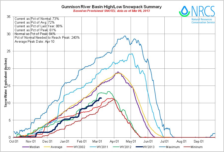
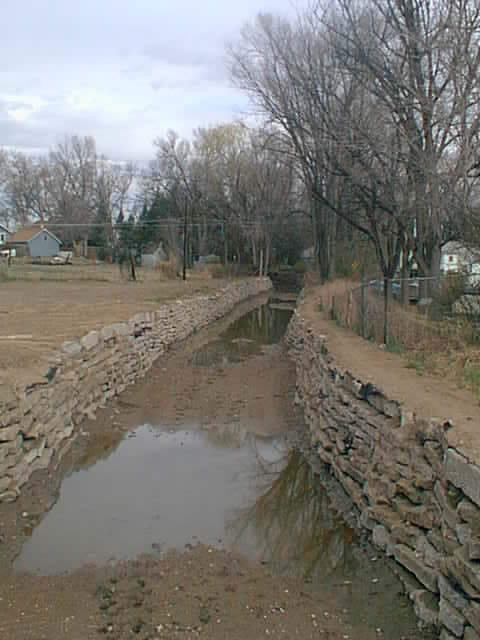
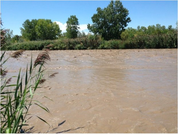
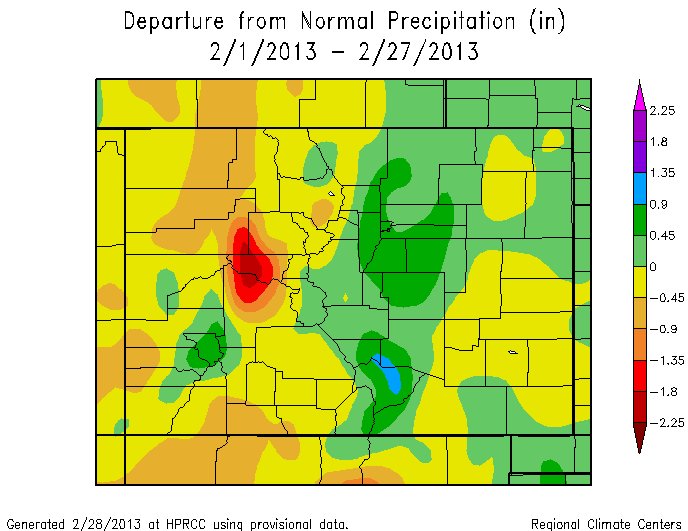
    To the relief of local ranchers, much of Weld County will end February with twice its average amount of moisture for the month — thanks largely to this past week’s snowstorms. Still, a lot more is needed, local producers say, to make up for the damage done by last year’s drought, and to produce the pasture and crops needed soon to feed their cattle and the newborn calves arriving on their ranches every day during this time of year.

    March is known as one of Colorado’s snowiest months, and local producers are praying, they say, that next month lives up to its reputation. “A few more of these, and we can get back to normal,” Kersey-area rancher Boyd Collins said, referring to the approximately one inch of precipitation that came with the deluge of snow this past week.

    That moisture, alone, more than doubled the 0.45 inches of precipitation the Greeley area typically receives in all of February. “Three, four, five inches (of precipitation) can do it for pastures. Hopefully we get it,” added Collins, joined at his ranch Wednesday morning by Dale Jackson, a neighboring rancher and president of the Weld County Livestock Association. The two had spent the morning saving a newborn calf, receiving some assistance from Toma — Collins’ dog, which he estimates, while slightly laughing, can cover the workload of about nine men.

    In addition to the recent snows, local ranchers, like Collins and Jackson, are grateful for today’s good cattle prices, expected to hit new record highs this year, with the U.S. herd is at its smallest since 1952.

    But there’s still concerns for their cattle and their operations — mostly the weather. Already, Collins has had to shrink the size of his herd because of drought, and he’ll have to further downsize, he says, if rains don’t come. Prior to the 2002 drought, Collins’ ranch would produce about 125 head each year during the calving season, which stretches from winter into the spring. As a result of that drought, Collins reduced his herd size, and it took him about five years to get back to where his ranch was calving more than 100 head each year. This year — after once again reducing his herd size because of the 2012 drought — he’s only expecting about 75 calves.

    Like Collins, many others have had to shrink their herds recently — troubling news to feedlots and beef packers, who have been swimming in red ink for several months, ag economists say, as a result of the tightened U.S. cattle herd. The tight supply of cattle has increased competition for cattle and the prices feedlots are paying ranchers, while the drought also has increased their feed costs. And because of the small herd, there’s less cattle going to slaughter at packing plants, with production not keeping up with operating costs.

    This year, the situation led to the decision to close a Cargill packing plant in Texas that employs about 2,000 people. “We know we need to expand the herd … but, honestly, I just don’t know anyone who’s expanding this year,” Collins said.

    According to new U.S. Department of Agriculture 10-year projections released this month, cattle numbers aren’t expected to reach pre-drought levels until 2017 or 2018.“There’s still just too much uncertainty,” said Jackson, noting that on his ranch, he can typically grow enough crops on his own ground to feed his cattle, but last year, had to buy half of the feed he needed.

    Boyd said he was able to grow enough feed on his own ground last year to get his cattle through this winter and the coming spring. But without pasture grass this summer, he, too, will have to buy feed, which is in short supply because of the drought, and, like cattle, has hit historically high prices.

    In addition to his own acreage, Boyd, like many other ranchers, has agreements with the government to put cattle on the Pawnee National Grasslands in Weld County to graze, usually from summer into the fall. Boyd’s lease allows him to put up to 55 head on that ground, he said, but, because the 2012 drought depleted the grass, he was only able to put 20 head out there last year. He expects that, if the drought persists, he’ll be restricted to have even less cattle on the Pawnee National Grasslands, if any at all. “It’s said a lot, but we just need moisture,” Boyd said. “It’s that simple.”