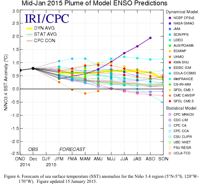
The latest ENSO Diagnostic Discussion is hot off the presses from the Climate Prediction Center

midjanuary2015plumeofmodelensoperdictions

Click here to read the discussion. Here’s an excerpt:

ENSO Alert System Status: El Niño Watch

Synopsis: There is an approximately 50-60% chance of El Niño within the late Northern Hemisphere winter and early spring, with ENSO-neutral slightly favored thereafter.

Equatorial sea surface temperatures (SST) remained above average in the western and central Pacific during January 2015 and cooled across the eastern Pacific. Accordingly, the latest weekly Niño indices were +0.5°C in the Niño-3.4 region and +0.9°C in the Niño-4 region, and closer to zero in the Niño-3 and Niño-1+2 regions. Subsurface temperature anomalies across the eastern half of the equatorial Pacific also averaged near zero during the month. However, an extensive area of positive subsurface anomalies persisted near the Date Line, while negative anomalies were prevalent closer to the surface east of 110°W. During the last couple of weeks of January, several aspects of the tropical Pacific atmosphere showed some movement toward El Niño. However, for the month as a whole, the equatorial low-level winds were mostly near average across the Pacific, while upper-level easterly anomalies continued in the east-central Pacific. Also, convection remained below average near the Date Line and enhanced in the western equatorial Pacific. While the tropical Pacific Ocean is at the borderline of El Niño, the overall atmosphere-ocean system remains ENSO-neutral.

Similar to last month, most models predict a weak El Niño (3-month values of the Niño-3.4 index between 0.5°C and 0.9°C) during the Northern Hemisphere late winter and spring. The forecaster consensus also favors Niño-3.4 SST index values in excess of 0.5°C within the coming season. However, climatologically, ocean-atmosphere coupling tends to weaken into the spring, which increases uncertainty over whether El Niño conditions will emerge. In summary, there is an approximately 50-60% chance of El Niño within the late Northern Hemisphere winter and early spring, with ENSO-neutral slightly favored thereafter.

USBR: Study Reveals Climate Change Impacts on Irrigation Demand and Reservoir Evaporation in the West

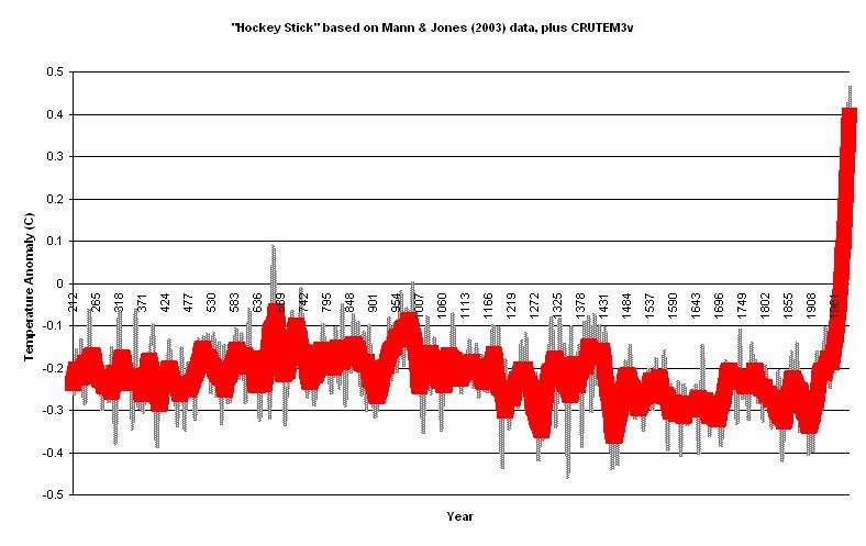
Hockey Stick based on Mann & Jones 2003

Click here for the release:

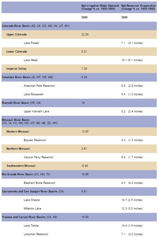
Reflecting current climate projections for the western United States, a new report issued by the Bureau of Reclamation reveals a projected shift in demand for crop irrigation across eight major river basins. The study evaluated irrigation water requirements for the second half of the 20th century and, as compared to projected demand for the second half of the 21st century, found that net irrigation water requirements in the West may be six percent higher. Another area of study revealed in the report – based on a projected temperature increase of approximately 5 degrees Fahrenheit in the region – estimates that annual evaporation at most of the 12 reservoirs modeled by the study could increase 2 to 6 inches by 2080.

The report on irrigation demand and reservoir evaporation projections is the latest in a series of West-Wide Climate Risk Assessments – analyses of overall impacts from climate change on water resources in the West through the Department of the Interior’s WaterSMART Program.

In announcing the report, Reclamation Commissioner Estevan López said the study was an important piece of information about climate change imposing stresses on water resources and will ultimately help inform water planners and stakeholders in confronting future climate-related supply and demand challenges.

“Reclamation and its partners are engaged in critical work to confront a future with increasing disparity between water supply and demand in basins throughout the West,” Commissioner López said. “Understanding how climate change will impact crop irrigation demand and reservoir evaporation provides vital information for the development of alternatives and solutions to meet those challenges and support the nation’s economy.”

Projected future irrigation demands are only estimates and provide a starting point for further analyses and discussions with customers and stakeholders. The results do not account for changing crop patterns and other socioeconomic considerations that are best addressed with stakeholder input within a basin study or other process.

Using climate projections for temperature and precipitation, scientists considered projected irrigation demand in eight major river basins: Colorado, Rio Grande, Sacramento-San Joaquin, Truckee, Columbia, Missouri and Klamath. The water evaporation model was applied to 12 reservoirs in many of those major Reclamation river basins: Lake Powell, Lake Mead, American Falls Reservoir, Lake Roosevelt, Upper Klamath Lake, Canyon Ferry Reservoir, Boysen Reservoir, Elephant Butte Reservoir, Lake Shasta, Millerton Lake, Lake Tahoe and Lahontan Reservoir. This table provides one set of projections of irrigation demand by basin and potential changes in evaporation for the twelve reservoirs when compared to actual figures from 1950 to 1999:

evaportationinwestunderclimatechangeusbr

Scientists utilized climate change data to project alterations in precipitation and temperature and to assess evaporation for 12 reservoirs within those river basins, when considering observed and projected climate change impacts. Precipitation projections are highly variable and basin dependent, and they can vary significantly within individual basins as well.

“Through these studies, Reclamation is highlighting climate change impacts and encouraging a collaborative dialogue on the effective management of our water and power resources,” López said. “Facing the challenge in meeting future irrigation demands is one way we are working to underscore our commitment to a strong agricultural economy and national food security.”

Reclamation’s West-Wide Climate Risk Assessment is part of the Department of the Interior’s WaterSMART Program, which focuses on improving water conservation and sustainability, while helping water resource managers make sound decisions about water use. The report may be found at http://www.usbr.gov/WaterSMART/wcra.

Snowpack news: Colorado January driest since 1986 — statewide 1.4 inches of SWE

Click on a thumbnail graphic to display a gallery of snowpack data from the Natural Resources Conservation Service.

Here’s the latest snowpack news release from the Natural Resources Conservation Service (Brian Domonkos):

Looking back at Colorado’s mountain snowpack over the course of January, it is becoming increasingly difficult to find promising water supply outlooks for spring and summer 2015. At the very end of December a dry spell began that persisted through the entire month of January, with the only relief being a few brief periods of active weather. While actual observed snowpack values in no way decreased over the course of January 2015, the snowpack percents of normal in every basin across the state did decline, in some cases drastically. The North Platte and combined Yampa/White River basins experienced deficits in snowfall which decreased snowpack percents of normal 23 and 26 percentage points respectively over the course of January. The combined Yampa/White watersheds saw the lowest snow accumulation in the calculated period of record back to 1986. According to statewide SNOTEL data, 1986 was the only drier January going back 29 years. January 1992 saw the same snow accumulation totals as this January with an increase of only 1.4 inches of snow water equivalent. “With nearly one third of the winter remaining, Colorado is running short of time to catch up.” commented Brian Domonkos, Colorado Snow Survey Supervisor. He went on to mention, “Statewide snowfall would need to amount to 124% of normal from now until mid- April to achieve normal snowpack peak levels.”

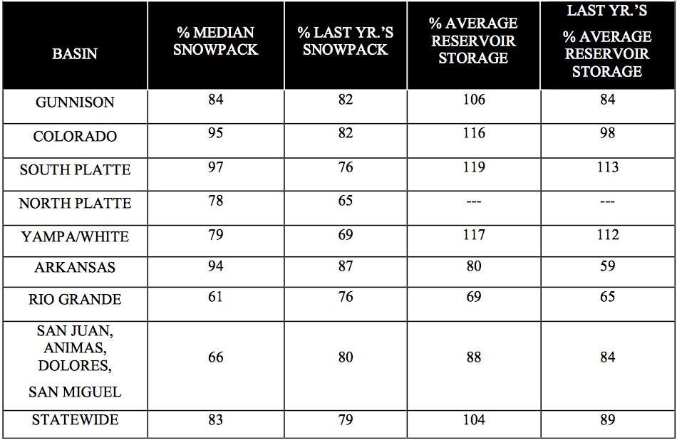
There are a few bright spots around the state. Watersheds that still retain an above normal snowpack include the Blue River at 122% as well as a few other sub-watersheds within the Colorado and South Platte River basins. Of the major basins, the South Platte, Colorado, and Arkansas all remain near normal at 97%, 95% and 94% respectively.

January is an important month for mountain precipitation over the course of the average year. The month of April typically provides the most mountain precipitation at 3.6 inches, followed by March at 3.4 inches, and January coming in the third highest at 3.2 inches. This January provided only 1.4 inches of mountain precipitation, 45% of the average. The South Platte saw the greatest precipitation totals compared to normal at 62% of average.

In terms of normal, statewide reservoir storage is only slightly below where it was last month, down one percentage point to 104% of average. The South Platte, combined Yampa, White & North Platte and Colorado River basins are riding higher than normal on carry over storage from the 2014 water year at 119%, 117%, and 116% of average respectively.

As always spring and summer outlooks for streamflow volumes vary greatly across the state, but the bulk are below normal between 60% and 85% of average.

Colorado February 1 snowpack and reservoir storage via the NRCS

Water Values podcast: @westgov’s great webinar series on western #drought

Sterling: New RO water plant online and slowly winning over rate payers

Reverse Osmosis Water Plant

From Radio Colorado College (Maeve Conran):

Coloradans pride themselves on the quality of their drinking water, most of which originates high up in the Rocky Mountains. But many communities on the Eastern plains have water that not only tastes bad, it’s out of compliance with federal drinking water standards.

Many diners at the J and L Cafe in downtown Sterling are sipping on glasses of tap water as they enjoy lunch on this December morning. That was not the case just a year ago.

“You couldn’t hardly drink it,” says Kathy Orchid, who says she never used to drink the tap water. “You could hardly drink it. It’s much better.”

The difference lies in the new multi-million dollar water treatment plant, less than a mile from the diner.

“The EPA…put the city on an enforcement order where we were basically told we had to fix the problem,” says Jeff Reeves, Sterling’s utilities superintendent, who supervises operations.

The city and the state had long been aware of problems with the drinking water, specifically that it contained radium and uranium, contaminants that can lead to kidney problems and bone cancer.

“All of these problems are naturally occurring,” says Ron Falco, who manages the Safe Drinking Water Program for the State of Colorado. “So this problem happens in the ground water as it’s moving through formations that may just have naturally high levels of radium or uranium.”

Falco says dozens of other communities, all on the Eastern Plains, are also struggling with water quality because like Sterling, they rely on ground water.

The EPA issued new drinking water standards in 2008, which meant those locations were now out of compliance with federal standards. Falco and other state health officials started working with the communities to improve the water systems.

“Historically, about 55 systems in the state of Colorado serving about 32000 people have struggled with uranium and radium in their drinking water,” says Falco. “By 2008, that number was at about 37 systems and about 21000 people.”

Sterling’s new water treatment plant is about a year old, and has put a dent in those numbers. This town of about 15,000 people in the South Platte River Basin was the largest municipality in the state facing this water quality issue.

The plant uses reverse osmosis to remove the uranium and radium. Reverse osmosis forces the water through a membrane, trapping contaminants which then form a concentrated brine.

But there are a couple of challenges. One is a 15% loss in usable water due to the treatment process, a significant figure for a region grappling with water quantity AND quality. The other problem is what to do with that wastewater.

Deep injection well
Deep injection well

Utilities manager Jeff Reeves says they’re storing that wastewater in an underground reservoir. “That’s down below an impermeable layer so it can’t get back up into the drinking water.”

Despite those two challenges, Reeves says the city of Sterling now has water that is well within federal standards. In addition, the reverse osmosis process has also improved the taste.

“We thought that we might as well make the water much more aesthetically pleasing,” says Reeves. “If you’re going to produce a product that people are going to have to pay for it’s a lot easier to get along with the customers if the water is good.”

More water treatment coverage here.

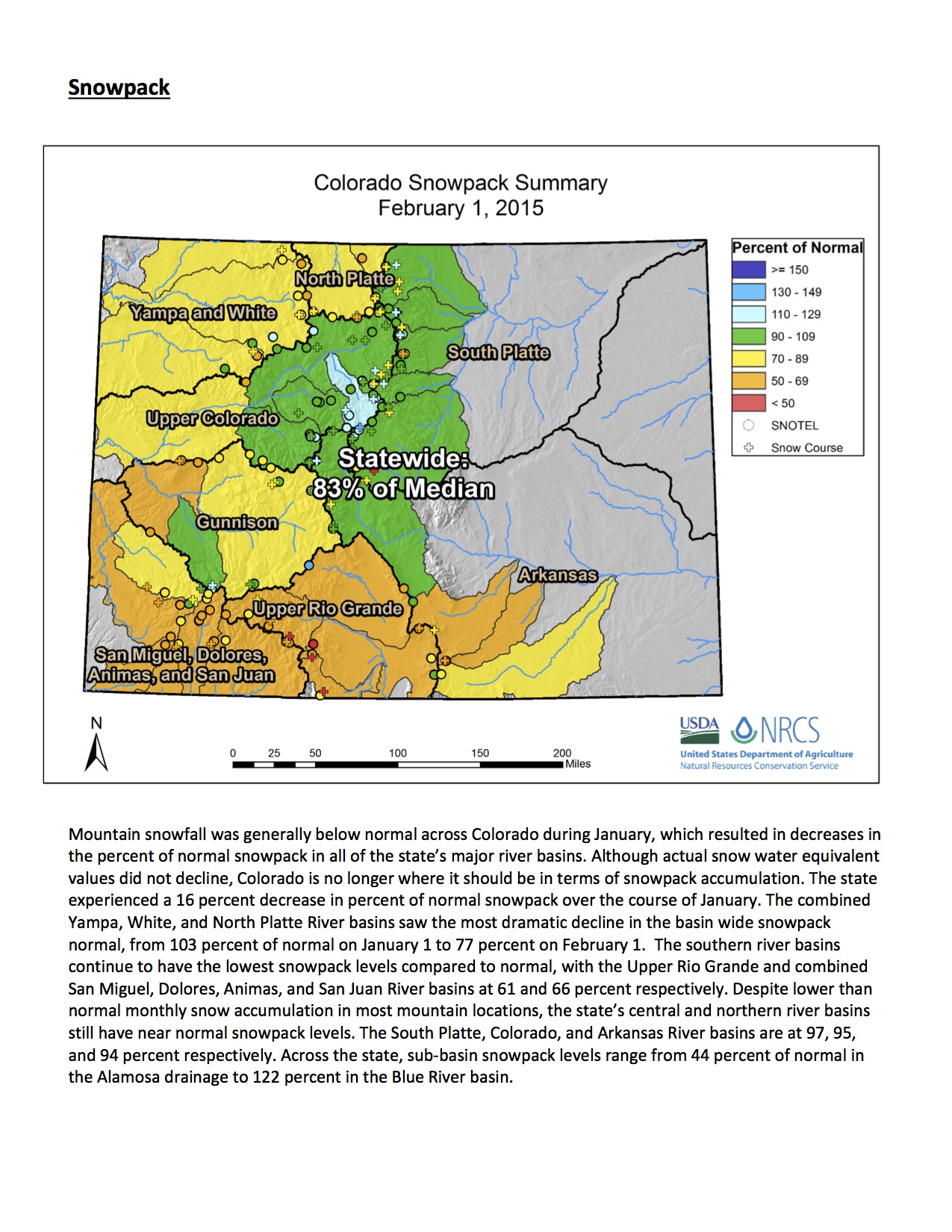
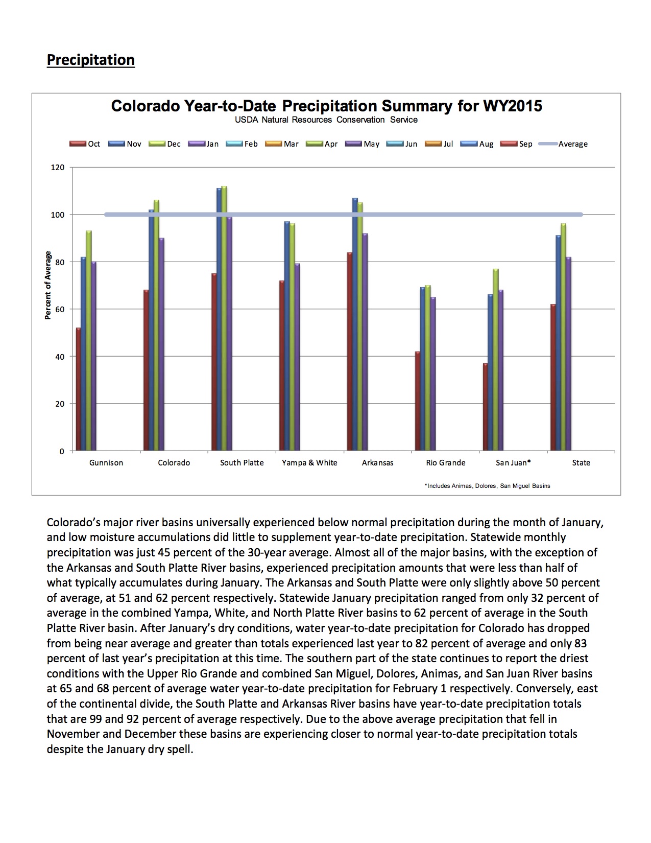
The February 1, 2015 Colorado Water Supply Outlook report is hot off the presses from the NRCS

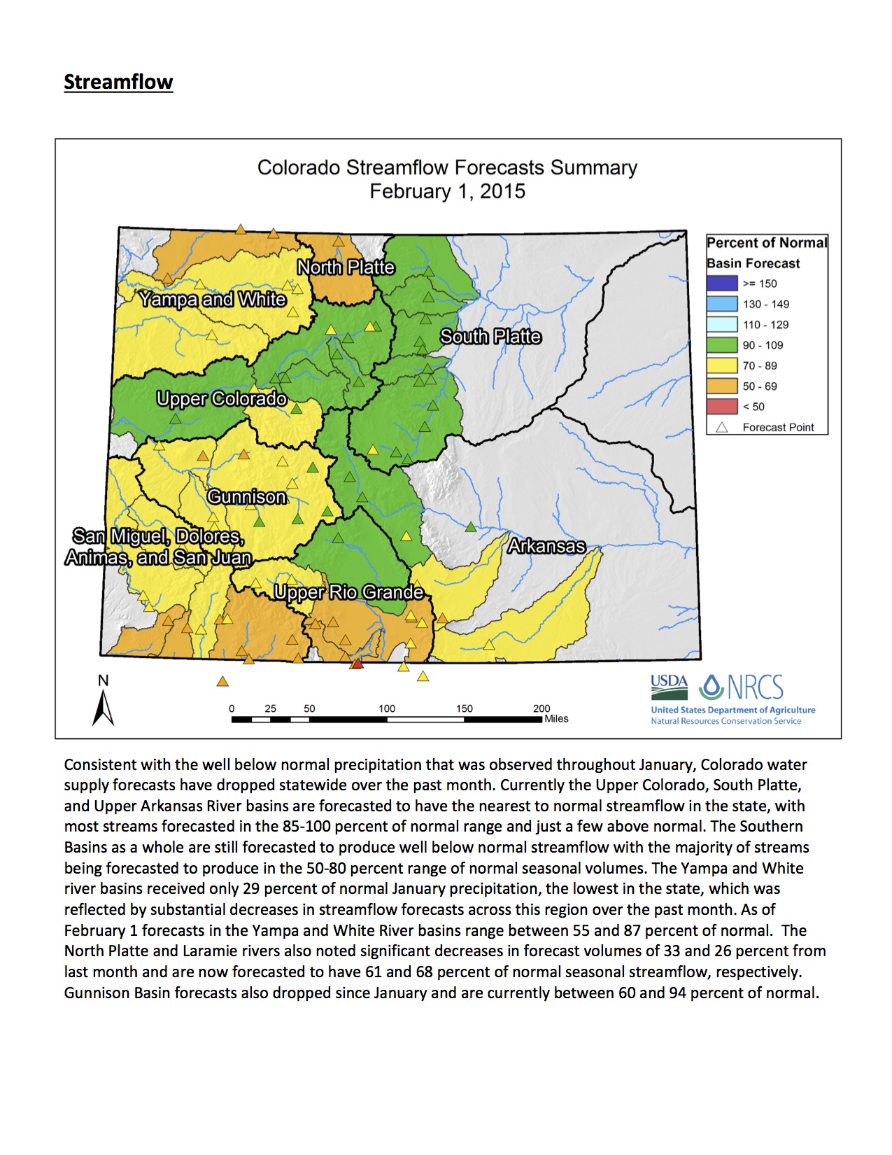
Click here to read the report. Here’s an excerpt (Click on a graphic for a larger view):

streamflowforecast02012015nrcs
snowpacksummarymap02012015
precipitationsummary02012015nrcs

Drought news: Abnormal dryness creeps back into western Colorado #ColoradoRiver

Click here to go to the US Drought Monitor website. Here’s an excerpt:

Summary

Temperatures were normal to above normal for most areas west of the Missouri River. The greatest departures from normal were over the central Rocky Mountains, where temperatures were 9-12 degrees Fahrenheit above normal. The eastern United States recorded temperatures below normal, with most areas 3-6 degrees Fahrenheit below normal for the week, and in New England, temperatures were 9-12 degrees Fahrenheit below normal. A strong storm system developed in the southwest and ejected onto the southern plains and into the Midwest. This was a storm with a great deal of moisture and it brought above-normal precipitation from Arizona up to Illinois. Portions of eastern Iowa to Chicago recorded over 12 inches of snow, with some areas approaching 20 inches for the event. The southeast, Mid-Atlantic, upper Midwest, and west coast remained dry with most areas slightly below normal for precipitation this week…

The High Plains

A warm week over the region, with temperature departures of 3-6 degrees Fahrenheit above normal common over the entire region. Much of Kansas and Nebraska were impacted by the same storm that brought precipitation to the southern plains and Midwest. The greatest precipitation was recorded over southeast Nebraska and northeast Kansas, which allowed for the improvement of D0 conditions this week…

The West

Consistent with what has been all too common over the west, temperatures were again well above normal for the week. The greatest departures from normal were over Wyoming, Colorado, Utah, and Nevada, where temperatures were 9-12 degrees Fahrenheit above normal for the week. Most other areas were 3-6 degrees Fahrenheit above normal. Arizona and New Mexico picked up some good precipitation, but this did little for snow accumulation in the upper elevations as there was more rain than snow. California remained dry as well as much of Washington and Oregon. The consistent issue in the west this current water year is the lack of snowfall, even in the highest elevations. The majority of the precipitation has fallen as rain, which has impacted many groups who count on snow for their livelihoods. Many valley locations are showing adequate rain this winter, but the same cannot be said for the upper elevations and their snow totals. This has made depicting drought quite difficult, as the runoff associated with the upper elevation snowpack is vital. With the precipitation in the region this week, improvements were made to southwest Arizona, southern Nevada, and southern California, where the impact of the summer monsoon along with the current precipitation has allowed for improvements. Areas of southwest New Mexico also were improved as the short-term precipitation has allowed conditions to start improving in the long term as well. D0 was expanded in Colorado this week to include more of the central portion of the state…

Looking Ahead

Over the next 5-7 days, the warm temperatures over the western half of the United States will continue. Much of the area with see daily high temperatures 6-12 degrees Fahrenheit above normal, with the greatest departure from normal high temperatures over eastern Colorado and western Kansas. Overnight lows are also expected to be above normal over most of the United States with overnight lows 6-18 degrees Fahrenheit above normal. The greatest departures from normal are expected over the northern Rocky Mountains. The area around the Great Lakes and New England is expected to be cooler than normal during this time with departures of 3-6 degrees Fahrenheit below normal for maximum and minimum temperatures. Precipitation chances look impressive from central California north toward Oregon and Washington. Amounts are projected to be quite high at this time, but with the warm weather, much of this precipitation is expected as rain, except at the highest elevations. This system is expected to impact most of the northwestern United States and into the northern Rocky Mountains. Precipitation is also expected to impact the Gulf Coast and along the eastern seaboard, into New England. Amounts of up 1-2 inches are projected at this time.

The 6-10 day outlook has warm temperatures likely to continue over the western two-thirds of the country while the best chances for below normal temperatures is expected over Alaska, New England, the Great Lakes region and along the east coast. Precipitation projections are showing that the greatest chance of above normal precipitation is over the northern plains and upper Midwest. The best chances for below normal precipitation take place over the southeastern United States and northern Alaska, especially over the lower Mississippi valley and Gulf Coast as well as in California and the Great Basin.

Volunteers sought for environmental work on Upper South Platte

Upper South Platte Basin

From The High Timber Times (Gabrielle Porter):

People looking to help out with environmental service work along the U.S. 285 Corridor can sign up to pull weeds, build trails or work on forestry projects with the Coalition for the Upper South Platte.

CUSP is moving into its first year of major concentration along U.S. 285, and has several projects on its summer agenda, said Bailey resident Jeff Ravage, the group’s North Fork watershed coordinator.

The nonprofit, founded in 1998, focuses on building a healthy watershed for the Upper South Platte River — more than 2,600 acres of land from which water drains into the river. The group secured funding to help with restoration work following the Hayman Fire in 2002.

This year, CUSP’s major priority is removing harmful non-native weeds from several areas, Ravage said. While CUSP has several sites on its summer agenda, Ravage said he would like to hear from area residents if they know spots plagued by non-native weeds.

Volunteers will also work on building part of a connecting trail at Staunton State Park. Some can help with forestry work. Because CUSP is a nonprofit, it can perform restoration work on state, federal and private land, Ravage said.

“We cross all fence lines, we like to say,” he said.

Groups can sign up to volunteer for several days or weeks on specific projects. CUSP also will be hosting several one-day work stints during the summer, so neighbors can join for shorter amounts of time, Ravage said.

Volunteers must be at least 16 years old, and those under 18 will need a guardian or responsible adult with them. All volunteers must sign waivers.

Aspinall Unit operations update: Releases from Crystal Dam to decrease today

Aspinall Unit
Aspinall Unit

From email from Reclamation (Erik Knight):

Releases from Crystal Dam will be decreased from 800 cfs to 600 cfs on Thursday, February 5th at 9:00 AM. This release decrease is in response to the declining runoff forecast for Blue Mesa Reservoir. The current forecast for April-July unregulated inflow to Blue Mesa Reservoir is 620,000 acre-feet which is 92% of average.

Flows in the lower Gunnison River are currently above the baseflow target of 1050 cfs. River flows are expected to stay above the baseflow target for the foreseeable future.

Pursuant to the Aspinall Unit Operations Record of Decision (ROD), the baseflow target in the lower Gunnison River, as measured at the Whitewater gage, is 1050 cfs for February.

Currently, diversions into the Gunnison Tunnel are zero and flows in the Gunnison River through the Black Canyon are around 850 cfs. After this release change Gunnison Tunnel diversions will still be zero and flows in the Gunnison River through the Black Canyon should be around 650 cfs. Current flow information is obtained from provisional data that may undergo revision subsequent to review.

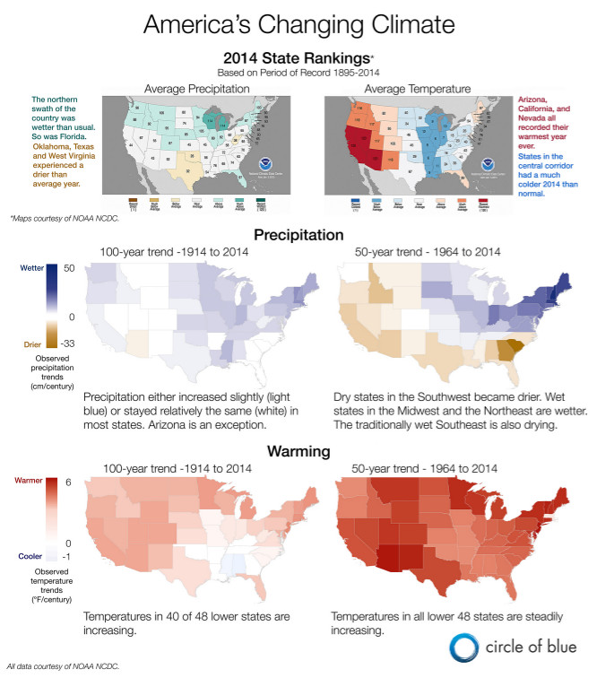
State of the climate infographic from Circle of Blue

NOAA_SOTC_2014viacircleofblue

Click on the graphic for a larger view. Infographic via Circle of Blue.

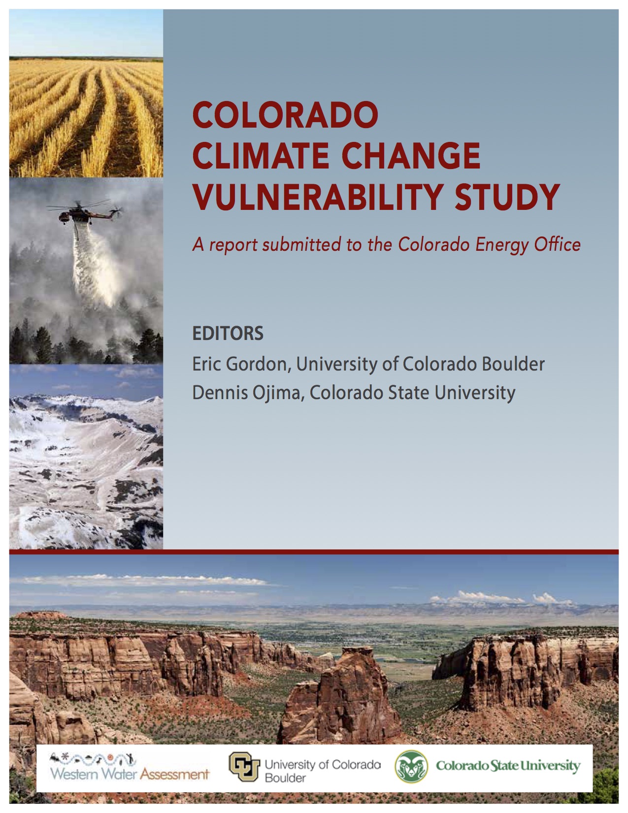
Colorado’s vulnerability to climate change

Colorado Climate Change Vulnerability Study cover

Here’s the link to the report announcement from Western Water Assessment, the University of Colorado, and Colorado State University.

From Colorado Public Radio (Megan Arellano):

Vulnerability is not just a question of how climate change will affect resources in the state, it’s also a question of how well Colorado is prepared to deal with changes,” said Eric Gordon, co-lead editor of the report and a researcher with the Western Water Assessment.

Longer and more intense droughts are likely across the state, so growing crops with irrigation is going to be “a little more difficult,” said Gordon. Even cattle eat less during hot weather, which means ranching will probably be impacted as well.

Additionally, the report notes that public schools on the Front Range haven’t needed to be air conditioned in the past. As temperatures rise, that change could be “expensive to address,” says the report.

Below, more on four vulnerable state sectors:

  • Water: The state’s reservoirs can provide some buffering against some expected increases in water demand and decreases in flow, but entities with junior rights or little storage are especially vulnerable to future low flows.
  • Agriculture: Rising temperatures, heat waves and droughts can reduce crop yield and slow cattle weight gain. Colorado farmers and ranchers are already accustomed to large natural swings in weather and climate, but may find it especially challenging to deal with expected changes in water resources.
  • Recreation: Climate projections show that Colorado’s springtime mountain snowpack will likely decline by 2050, with potential impacts on late-season skiing. Spring runoff season may also be earlier and shorter, which could affect rafting. But the recreation industry and some Colorado communities are already making changes that could help them adapt to a warmer future. For example, Telluride ski area now markets itself as Telluride Ski & Golf.
  • Transportation: As temperatures increase, rail speeds must drop to avoid track damage, leaving the freight and passenger rail industries vulnerable to slowdowns or the need for expensive track replacements.
  • From the Loveland Reporter-Herald (Charlie Brennan):

    Colorado could see more infectious disease, negative impacts on the elderly and people living in poverty, as well as stresses to water, cattle and crops as byproducts of future climate change, according to a comprehensive new report commissioned by the Colorado Energy Office.

    “The important takeaway is, here’s what’s important to Colorado,” said Eric Gordon, co-lead editor of the 176-page report and managing director of the Western Water Assessment at the University of Colorado. “We’re not talking about things that have nothing to do with us, like sea level rise. This is what’s important to Colorado and what we should be worrying about.”

    The exhaustive report includes chapters devoted to seven separate sectors where the state might show vulnerability to climate change — ecosystems, water, agriculture, energy, transportation, outdoor recreation and public health.

    Dennis Ojima, co-lead editor of the report and a professor in the Ecosystem Science and Sustainability Department at Colorado State University, noted the degree to which each of those sectors can be seen as intertwined with the others.

    For example, Ojima said, “In a warmer climate, we need more irrigation and more energy to support that, and more air conditioning in our area in the summer requires more energy, but also more water for cooling. These multiple constraints start occurring when you start looking at the whole state of the system.”

    Among noteworthy findings of the report:

  • Climate projections show that Colorado’s springtime mountain snowpack will likely decline by 2050, with potential impacts on late-season skiing. Spring runoff season may also be earlier and shorter, which could affect rafting.
  • The state’s reservoirs can provide buffering against some expected increases in water demand and decreases in flow, but entities with junior rights or little storage are especially vulnerable to future low flows.
  • Rising temperatures, heat waves and droughts can reduce crop yield and slow cattle weight gain. Colorado farmers and ranchers are already accustomed to large natural swings in weather and climate but may find it particularly hard to deal with expected changes in water resources.
  • The report, presuming a conservative level of future greenhouse gas emissions, nevertheless forecasts a 2.5- to 5.5-degree increase in statewide temperatures by mid-century, relative to a 1971-2000 baseline. Also, Colorado will be more prone to extreme precipitation events in winter, but not necessarily during the summer.
  • The report states that impacts on public health are complex and hard to anticipate, but climbing temperatures may mean more frequent episodes of bad air quality and more common heatstroke, plague, West Nile virus and hantavirus.

    Temperatures in Colorado have been rising, especially in summer, and that trend is expected to continue, along with increases in the frequency and intensity of heat waves and wildfire.

    Even public schools in many Front Range cities are vulnerable to these changes, the report stated. Historically, schools in the state have not often required cooling, so many do not have air-conditioned classrooms.

    Boulder County, in fact, is spending $37.7 million from a $576.5 million construction bond issue passed in November to provide air conditioning to eight schools that don’t have it (five of which hold summer sessions).

    ‘How do we use this report to move forward?’

    The report was lauded by Stephen Saunders, president of the Louisville-based Rocky Mountain Climate Organization.

    “This first-ever state-specific synthesis of existing information on how climate change may affect us here will be very valuable to the state government, to local governments, and indeed to all Coloradans,” Saunders said. “Now, the question is, how do we use this report to move forward?”

    Saunders added, “The report itself points to the importance of preparedness actions by the state government, local governments and others to reduce our risks of future impacts. We believe those state government actions should include both a comprehensive state-government-wide preparedness plan, and specific actions by individual state agencies to factor climate change risks into their plans and management actions.”

    In its concluding chapter, titled “Moving Toward Preparedness,” the report cites the Boulder County Climate Change Preparedness Plan for its overarching principles and suggests they should be integrated into “all forms of planning” to provide resilience in the face of future climate impacts.

    Some of those principles are ensuring flexibility, removing barriers to adaptation, recognizing the need for leadership and collaboration, plus preparing for multiple possible climate futures.

    From the Fence Post (Nikki Work):

    The report, called the Colorado Climate Change Vulnerability Study, was compiled by representatives of the Western Water Assessment, Cooperative Institute for Research in Environmental Sciences, the University of Colorado-Boulder, Colorado State University and National Center for Atmospheric Research. According to a press release from the Cooperative Institute for Research in Environmental Sciences, the report was compiled using existing data and literature. The researchers then found issues in a variety of sectors, including public health, water, agriculture, recreation and transportation.

    “Vulnerability is not just a question of how climate change will affect resources in the state, it’s also a question of how well Colorado is prepared to deal with changes,” said report co-lead editor Eric Gordon in the release. Gordon is a researcher with the Western Water Assessment.

    The report discusses the warming trend in Colorado and the effects it could have. Examples of potential problems include reduced crop yield, cattle feeding, drought, less available water to those with junior rights and/or little storage, a decrease in snowpack, possible increases in the prevalence of West Nile Virus and the necessity of slower rail speeds to avoid infrastructure damage.

    “We also know vulnerabilities change over time, as environmental and socio-economic conditions change,” said the report’s co-lead editor and professor at CSU Dennis Ojima in the release. “It will be important to keep an eye on this changing landscape of vulnerability.”

    The full report is available at http://wwa.colorado.edu/climate/co2015vulnerability/.

    Colorado Springs to make a pitch to become wildfire research hub — The Colorado Springs Gazette


    From The Colorado Springs Gazette (Ryan Maye Handy):

    Colorado Springs is making a pitch to host a new state-funded center for fire research, a technology hub that could help propel Colorado to the forefront of revolutionizing how wildfires are fought.

    The Colorado Springs Regional Business Alliance plans to submit a report this week detailing why El Paso County, twice victim of catastrophic wildfire, should be the new home for the fire research center.

    While the public eye may have been trained on the Colorado Firefighting Air Corps created last year, a lesser-known aspect of the Centennial-based fleet – the Center for Excellence for Advanced Technology Aerial Firefighting – has been on the wish list for some Colorado Springs leaders for months.

    The center, also created in 2014, is looking for a home, and state officials have asked Colorado’s cities to submit Requests for Information, or RFIs – non-binding proposals asking the state to consider a city in its decision making process.

    If Colorado Springs is selected, the city could become an epicenter for cutting-edge firefighting technology, said Tony Kern, a former assistant director of fire aviation and management for the U.S. Forest Service who has helped with the business alliance’s proposal.

    Kern believes that Colorado Springs is an ideal spot to become the state’s leader in tech-savvy firefighting.

    “There really is no other place that even remotely has the capability or the experience” to support the research center, he said.

    Submitting an RFI by Friday’s deadline will not determine the state’s decision, but it will serve as a guideline, said Melissa Lineberger, the center’s interim director. Money for the center comes from the state’s general fund – last year, the center received $274,252, and was expected to receive $777,437 for the 2015-2016 fiscal year. Lineberger expects the new center to be up and running in August.

    The state is looking for cities that are centrally located with access to airports but without much air traffic. State officials also want the center’s home city to be a “desirable place to live” with a nearby university, and have the backing of the local county and city government.

    Colorado Springs has it all, Kern thinks, although the city may end up competing with Fort Collins-Loveland if the Larimer County cities submit a proposal.

    The business alliance is working with the city of Colorado Springs on the plan, said Andy Merritt, the alliance’s Chief Defense Industry Officer. Kim Melchor, a spokeswoman for the city, was not aware of the city’s involvement in the pitch; officials with city’s office of emergency management could not be reached on Wednesday.

    El Paso County’s mix of mountains, forests and wildland urban interfaces represent the rest of the state, making it ideal for aircraft testing, Kern said.

    Colorado Springs also has access to military bases and their aircraft, which can be used to bolster a firefight from the air. Kern also believes that Colorado Springs has only airport aside from Denver International Airport that can handle oversized air tankers.

    Lastly, the county’s recent wildfire history has made it a place for research, Kern said.

    In June 2012, the Waldo Canyon fire ignited west of Colorado Springs, destroying 347 homes and killing two people. In early June 2013, the Black Forest fire started in northeastern El Paso County, and rapidly surpassed Waldo in its destruction – claiming 488 homes and two lives, the most destructive fire in Colorado history.

    The fires caught the attention of researchers and firefighters from around the world, and continue to be the focus of study.

    The center will be plugged into two PC-12s planes equipped with remote sensing thermal technology. The planes are rarely used to fight fire, but can spot remote fires long before crews can reach them. The planes have the ability to fly at night, something that the forest service prohibits when fighting wildfire, Kern said.

    “That will revolutionize the firefighting industry,” said Kern, who spent five years as the head of aerial fighting for the Forest Service in the early 2000s. “If we could get air tankers on or dropping water or retardant on fires at night, that would be a huge breakthrough.”

    While with the Forest Service, Kern oversaw the grounding of a massive fleet of more than 44 air tankers, most of which were deemed too old to fly. The Forest Service has yet to recoup its loses, and has since struggled to create a fleet of so-called next-generation air tankers to help cover a spate of wildfires from Colorado to Washington state.

    While the Forest Service struggles to resolve its own issues with wildfire response, Kern hopes that Colorado’s firefighting fleet will be at the forefront when it comes to changing firefighting and possibly serve as a leader for the federal government. If Colorado Springs gets the research center, Kern believes that between 500 and 1,000 jobs could be added in coming years.”The first big hurdle is where it is going to be,” said Kern of the center.

    Western Water Assessment, et al., release report “Charting Colorado’s Vulnerability to Climate Change”

    co_vulnerability_report_2015_final cover
    Here’s the release from Western Water Assessment, the University of Colorado, and Colorado State University:

    Sea-level rise may not be not eating away at Colorado’s borders, but climate change exposes other critical vulnerabilities in the state, according to a new report. Rising temperatures will likely take a toll on cattle and crops, for example, and could more often leave junior water rights holders with little water and few options.

    The new report, “The Colorado Climate Change Vulnerability Study,” was commissioned by the Colorado Energy Office in accordance with the Colorado Legislature’s HB13-1293. It’s a sector-by-sector analysis of the challenges that state residents and leaders will have to deal with in coming decades. It also details many of the ways Coloradans are already grappling with these issues, and where other strategies may help mitigate risk.

    “Vulnerability is not just a question of how climate change will affect resources in the state, it’s also a question of how well Colorado is prepared to deal with changes,” said Eric Gordon, co-lead editor of the report and a researcher with the Western Water Assessment (WWA). WWA is part of the Cooperative Institute for Research in Environmental Sciences (CIRES) at the University of Colorado Boulder, and is funded primarily by NOAA.

    “We also know vulnerabilities change over time, as environmental and socio-economic conditions change,” said Dennis Ojima, co-lead editor of the report and a professor in the Ecosystem Science and Sustainability Department at Colorado State University. “It will be important to keep an eye on this changing landscape of vulnerability.”

    In the public health sector, Colorado may see more incidents of infectious diseases, the report notes, and the elderly and people living in poverty are especially vulnerable. Climate change impacts on public health are complex and difficult to anticipate, but rising temperatures could mean more frequent episodes of unhealthy air quality and more common heatstroke, West Nile virus, plague and hantavirus.

    For perspective, hotter states such as Florida and Arizona are also dealing with the invasion of diseases typically not seen in the continental United States, such as dengue fever.

    “Colorado is lucky to avoid certain diseases that affect hotter areas,” Gordon said, “but we are vulnerable to increases in those we already have here, especially West Nile virus.”

    Temperatures in Colorado have been rising, especially in summer, and that trend is expected to continue, along with increases in the frequency and intensity of heat waves, droughts and wildfire. Public schools in many Front Range cities are vulnerable to these changes, the report notes. Historically, schools in the state have not needed cooling, so many do not have air-conditioned classrooms. “These rising temperatures have exposed a major vulnerability that could potentially be very expensive to address,” the report notes.

    “As we assess impacts on various communities, we find that various sectors are affected differently,” Ojima said. “For example, droughts would affect streams and fisheries differently than agricultural or energy producers.”

    Among other findings, by sector:

  • Water: The state’s reservoirs can provide some buffering against some expected increases in water demand and decreases in flow, but entities with junior rights or little storage are especially vulnerable to future low flows.
  • Agriculture: Rising temperatures, heat waves and droughts can reduce crop yield and slow cattle weight gain. Colorado farmers and ranchers are already accustomed to large natural swings in weather and climate, but may find it especially challenging to deal with expected changes in water resources.
  • Recreation: Climate projections show that Colorado’s springtime mountain snowpack will likely decline by 2050, with potential impacts on late-season skiing. Spring runoff season may also be earlier and shorter, which could affect rafting. But the recreation industry and some Colorado communities are already making changes that could help them adapt to a warmer future. For example, Telluride ski area now markets itself as Telluride Ski & Golf.
  • Transportation: As temperatures increase, rail speeds must drop to avoid track damage, leaving the freight and passenger rail industries vulnerable to slowdowns or the need for expensive track replacements.
  • The new, 176-page report is available at on the Western Water Assessment’s website: http://wwa.colorado.edu/climate/co2015vulnerability/. It is a summary of existing available data and research results from the peer-reviewed literature, and was compiled by researchers at the Cooperative Institute for Research in Environmental Sciences (CIRES), the University of Colorado Boulder, the Natural Resource Ecology Laboratory at Colorado State University, the North Central Climate Science Center, and the National Center for Atmospheric Research. Thirty experts from state offices, consulting groups and academia reviewed the report.

    CIRES is a partnership of NOAA and the University of Colorado Boulder.

    WWA, at CU-Boulder, is a NOAA Regional Integrated Sciences & Assessment (RISA) program.

    The North Central Climate Science Center is a partnership with the Department of Interior and Colorado State University.

    Contacts:
    Eric Gordon, co-lead editor, CIRES Western Water Assessment, University of Colorado Boulder, esgordon@colorado.edu, 303-492-4766
    Dennis Ojima, co-lead editor, Colorado State University, dennis.ojima@colostate.edu, 970-491-1976
    Katy Human, CIRES communications, Kathleen.human@colorado.edu, 303-735-0196
    Kate Jeracki, CSU external relations, kate.jeracki@colostate.edu, 970-491-2658
    – See more at: http://cires.colorado.edu/news/press/2015/climatechange.html#sthash.noDom6ZH.dpuf

    Environment: EPA says Keystone XL pipeline could add 1.37 billion tons of ‘extra’ greenhouse gases to atmosphere

    Snowpack news: “We’ve had very warm nights for this time of year” — Charles Kuster

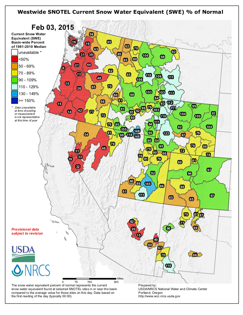
    Westwide SNOTEL snow water equivalent as a percent of normal February 3, 2015 via the NRCS
    Westwide SNOTEL snow water equivalent as a percent of normal February 3, 2015 via the NRCS

    From The Pueblo Chieftain (Chris Woodka):

    If this were a postcard winter, it would be the kind in which a polar bear in sunglasses was enjoying a tropical drink and a lot of the words in the message were crossed out and scribbled over.

    On paper, everything looks pretty average. But there have been twists of extreme cold and higher-than-normal temps, snowpack that built up early and began to dwindle and the typical uncertainty of how things will play come springtime.

    Snowpack for Colorado as a whole was just 81 percent of median as of Tuesday, but that’s no indication of how it will turn out or even of how it is in any given part of the state.

    Most of the snowpack is clustered over the central mountains at the top of watersheds that feed into the Arkansas, Colorado and South Platte basins — all of which are almost at normal levels.

    The outlying parts of the state are drier than normal.

    “What’s unusual is that we normally see very cold weather in the December-February time period,” said Charles Kuster, who watches the weather closely in the Leadville area. “This year, I’ve only recorded 26 days with lows of 0 degrees (Fahrenheit), and the average is usually about 60 days of those type of temperatures.”

    The high temperature in Leadville was 50 degrees on Jan. 26, and the lows were 7 degrees above average overall.

    That has played havoc with a snowpack that built up generously in November and December, but suffered in January. Kuster recorded just a foot of snow last month, about 17 inches below normal.

    “We’ve had very warm nights for this time of year,” he said. “Normally that’s not a factor. But even with the low sun angle, we’re seeing some melting. It’s unusual to have significant melting this time of year.”

    Still, some sites in the Leadville area remain well above normal, such as Fremont Pass, which is sitting at 123 percent of median in snowpack and 124 percent of average precipitation since October.

    The Rio Grande basin is just at 65 percent of median snowpack, the driest area of the state.

    Colorado’s Southeastern corner still is in severe drought, according to the U.S. Drought Monitor.

    The National Oceanic and Atmospheric Agency’s three-month outlook is calling for aboveaverage precipitation and below-average temperatures for Southeastern Colorado.<,/blockquote>

    CWCB meeting recap: $29,000 for compliance study until Arkansas Valley Conduit is online

    Arkansas Valley Conduit Comanche North route via Reclamation
    Arkansas Valley Conduit Comanche North route via Reclamation

    From The Pueblo Chieftain (Chris Woodka):

    New state regulations are creating a headache for Arkansas Valley water providers who are banking on the Arkansas Valley Conduit to improve water quality.

    The Colorado Water Conservation Board approved a $29,000 grant this week that will go toward a $70,000 program to create a working group to chart a course of action for 38 communities until the conduit is completed.

    Water in many of the systems is contaminated by metals, salts and/or radionuclides and managing treatment of the water is more complicated because of recent solid waste regulations by the Colorado Department of Health and Public Environment.

    That’s created a hardship because smaller private water companies do not have the resources to comply or even determine compliance and the state has not clearly explained what is or is not required. The regulation presumably covers disposal of by-products.

    There are ongoing concerns about radionuclides, which affect 12 of the communities.

    The $400 million conduit, which will move water from Lake Pueblo to Lamar and Eads, is seen as the best solution to the water quality problems for about 50,000 people. However, construction of the conduit might be a decade away from reality.

    The Southeastern Colorado Water Conservancy District and Lower Arkansas Valley are contributing $7,500 each toward the project, as well as $27,500 in inkind services.

    More CWCB coverage here.

    President Obama’s proposed budget includes $1.1 billion to fund Reclamation water projects

    President Obama at Hoover Dam
    President Obama at Hoover Dam

    Here’s the release from the Bureau of Reclamation:

    President Obama’s Fiscal Year 2016 budget request released today identifies a total of $1.1 billion for the Department of the Interior’s Bureau of Reclamation, continuing the President’s commitment to be prudent with taxpayer dollars while setting consistent spending priorities for Reclamation. The budget would provide robust investments in the safety, reliability and efficiency of America’s water infrastructure and in conservation, reuse and applied science to address the nation’s water supply challenges, especially in the West.
    As the nation’s largest wholesale water supplier and second-largest producer of hydroelectric power, Reclamation’s projects and programs are critical to driving and maintaining economic growth in the western States.

    “President Obama’s budget for Reclamation reflects a strong commitment to our ongoing mission of effectively managing water and power in the West,” Commissioner Estevan López said. “Reclamation and its partners provide water and clean hydropower for communities across 17 states. With the resources provided in this budget blueprint, we can continue to be an engine of progress across multiple sectors of the western U.S. economy.”

    The proposal for Reclamation’s Water and Related Resources account of $805.2 million includes $367.4 million for resource management and development activities. This funding provides for planning, construction, water conservation activities, management of Reclamation lands—including recreation— and actions to address the impacts of Reclamation projects on fish and wildlife. The request also emphasizes reliable water delivery and power generation by requesting $437.7 million to fund operation, maintenance and rehabilitation activities at Reclamation facilities, including dam safety.

    The budget emphasizes Reclamation’s core mission to address the water demands of a growing population in an environmentally responsible and cost-efficient manner; and to assist states, tribes and local entities in solving water resource issues. It also emphasizes the operation and maintenance of Reclamation facilities in a safe, efficient, economic and reliable manner—ensuring systems and safety measures are in place to protect the public and Reclamation facilities.

    Reclamation’s funding request addresses Administration, Interior, and Reclamation priorities. The budget supports water rights settlements to ensure sufficient resources to address the requirements of legislation passed by Congress to settle litigation. The request includes increases for specific Indian water rights settlements that support the goal of strengthening tribal nations.

    The FY 2016 budget proposal also balances needs for climate variability adaptation, water conservation, improving infrastructure, sound science to support critical decision making and ecosystem restoration.

    Reclamation’s challenges – The extreme and prolonged drought facing the West affects major U.S. river basins in virtually every western state. The effects of the current drought on California water, its agricultural economy and its communities are topics of nationwide concern and extensive media coverage. The Colorado River Basin—crucial for seven states and several Tribes, in addition to two countries—is also enduring historic drought. About 33 million people rely on the Colorado River for some, if not all, of their municipal needs.

    Reclamation’s dams, water conveyances and power generating facilities are critical components of the Nation’s infrastructure. Protecting and extending the lives of these structures are among the many significant challenges facing Reclamation over the next several years and beyond. They present major hurdles to achieving progress on water supply confidence, sustainability and resiliency. Reclamation’s water and power projects and activities throughout the western United States are a foundation for essential and safe water supplies, provide renewable hydropower energy and sustain ecosystems that support fish and wildlife, recreation and rural economies. Climate variability and competing demands are increasingly affecting already-strained systems. The Bureau of Reclamation’s FY 2016 budget addresses these challenges and reflects a very deliberate approach to accommodating mission priorities.

    WaterSMART Program – The President’s proposed budget for Reclamation calls for $58.1 million for the WaterSMART Program – Sustain and Manage America’s Resources for Tomorrow — to assist communities in optimizing the use of water supplies by improving water management. The WaterSMART Program components include: WaterSMART Grants funded at $23.4 million; the Basin Studies Program, $5.2 million; the Title XVI Water Reclamation and Reuse Program, $20.0 million; the Water Conservation Field Service program, $4.2 million; the Cooperative Watershed Management program, $250,000; the Drought Response program $2.5 million; and the Resilient Infrastructure program, $2.5 million.

    Strengthening tribal nations – To meet trust and treaty obligations, Reclamation’s budget request makes Indian water rights settlements among the highest priorities. The FY 2016 budget proposes $112.5 million for a new account entitled Indian Water Rights Settlements to ensure continuity in the construction of four of the authorized projects and to highlight and enhance transparency in handling these funds. The budget includes $89.7 million for the ongoing Navajo-Gallop Water Supply Project (Title X of Public Law 11-11) as well as $22.8 million to continue implementation of three settlements authorized in the Claims Resolution Act of 2010. These settlements will deliver clean water to the Navajo Nation in New Mexico, the Taos Pueblo of New Mexico, the Pueblos of Nambe, Pojoaque, San Ildefonsi & Tesuque in New Mexico named in the Aamodt case and the Crow Tribe of Montana.

    Specifics of the budget request include:

    America’s Great Outdoors Initiative – Reclamation has a responsibility to focus on the protection and restoration of the aquatic and riparian environments affected by its operations. Highlights of Reclamation’s ecosystem restoration activities, many of which support Endangered Species Act (ESA) recovery programs, include:

    $16.7 million is for the Lower Colorado River Multi-Species Conservation Program to provide long-term Endangered Species Act (ESA) compliance for river operations.

    $24.4 million for ESA recovery implementation programs, including $17.5 million to implement the Platte River Endangered Species Recovery Implementation Program and $4.4 million for the Upper Colorado River Endangered Fish Recovery Programs. $6.8 million of the $18.0 million Klamath Project supports wildlife refuge and environmental needs, the remainder supports studies and initiatives to improve water supplies to meet the competing demands of agricultural and tribal and facilities operations and maintenance activities.

    $37.0 million for the California Bay-Delta Restoration, equal to the FY 2015 budget. The account focuses on the health of the Bay-Delta ecosystem and improving water management and supplies. The budget will support the co-equal goals of environmental restoration and improved water supply reliability, under the following program activities: $1.7 million for a Renewed Federal State Partnership, $7.2 million for Smarter Water Supply and Use, and $28.1 million for Habitat Restoration. These program activities are based on the Interim Federal Action Plan for the California Bay-Delta issued December 22, 2009.

    $49.5 million for the Central Valley Project Restoration Fund to continue funding a variety of activities to restore fish and wildlife habitat and populations in the CVP service area of California.

    Within California’s Central Valley Project (CVP), $11.9 million and an additional $1.5 million in the Central Valley Project Restoration Fund are for the Trinity River Restoration program.

    $9.5 million, as part of the Middle Rio Grande Project budget, targeted to support environmental activities developed through an Endangered Species Act Collaborative Program.

    $18.0 million for the Columbia and Snake River Salmon Recovery Project for implementation of the biological opinions for the Federal Columbia River Power System.

    Other project highlights –

    $123.0 million to operate, manage, and improve CVP. More than one-half of that amount provides for operation and maintenance of project facilities, including $20.3 million for the Replacements, Additions, and Extraordinary Maintenance program which provides for modernization, upgrade, and refurbishment of facilities throughout the Central Valley. The remainder supports studies and initiatives to improve water supplies and environmental needs.

    $36.5 million for rural water projects to undertake the design and construction of five projects and operation and maintenance of tribal features for two projects intended to deliver potable water supplies to specific rural communities and tribes located primarily in Montana, New Mexico, North Dakota and South Dakota.

    $12.8 million for the Yakima River Basin Water Enhancement Project, which will continue funding grants to implement conservation measures and monitor the effects of those measures on the river diversions. Funding is also included to continue construction on fish passage facilities at Cle Elum dam.

    $88.1 million for the Dam Safety Program to continue dam safety risk management and risk reduction activities throughout Reclamation’s inventory of dams. Corrective actions are planned to start or will continue at a number of facilities. A focus continues to be modifications at Folsom Dam (California).

    $26.2 million for site security to continue Reclamation’s ongoing site-security program, which includes physical security upgrades at key facilities, guards and patrols, anti-terrorism program activities and security risk assessments.

    The Bureau of Reclamation, throughout the 17 western states, is committed to helping meet the many water challenges of the West. A driving force behind bureau initiatives is resolution of water issues that will benefit future generations and providing leadership on the path to sustainable water supplies.

    Weekly Climate, Water and Drought Assessment of the Upper #ColoradoRiver Basin

    Upper Colorado River Basin precipitation as a percent of normal January 2015 via the Colorado Climate Center
    Upper Colorado River Basin precipitation as a percent of normal January 2015 via the Colorado Climate Center

    Click here to go to the NIDIS website hosted by the Colorado Climate Center to read the latest briefing.

    2015 Colorado legislation: HB15-1006 (Invasive Phreatophyte Grant Program) makes it out of committee #coleg

    Tamarisk
    Tamarisk

    Click here to read the bill.

    From The Grand Junction Daily Sentinel (Charles Ashby):

    A House panel (House Committee on Agriculture, Livestock, & Natural Resources) unanimously approved a bill Monday to help local communities get rid of invasive species such as tamarisk and Russian olive trees because they drink up precious water.

    While it may seem like that’s a good idea, not everyone was enamored with the measure, HB1006, as drafted, because it doesn’t go far enough.

    It isn’t good enough just to get rid of the invasive plants, called phreatophytes. Native phreatophytes, such as cottonwoods and aspen, must be used to replace them to guard against erosion and maintain the animal habitat, those opponents said.

    “Simply eradicating existing phreatophytes under the term ‘invasive’ implies that we’re going to have additional problems with flooding, with sedimentation, that we’re going to have some of the same problems that led us into the issues we have with tamarisk,” Jennifer Bolton, a lobbyist for the Audubon Society, told the House Agriculture, Livestock & Natural Resources Committee.

    But other supporters, including the bill’s sponsor, Rep. Don Coram, R-Montrose, said the measure is tied to the state’s existing laws dealing with noxious plants.

    As a result, the Colorado Department of Agriculture is required to consider the entire health of a watershed, and not merely taking out a few noxious weeds here and there.

    Chris Treece, external affairs director for the Colorado River Water Conservation District, said he’s not worried both of those things won’t occur.

    “The clear purpose of this bill is to provide the resources to those who have the expertise, who have the programs set up, and would allow for the exercise of those programs,” Treece told the committee. “All of those programs … prioritize the proper removal, the proper weed control, the proper rehabilitation and restoration of the riparian area.”

    Regardless, the committee tacked an amendment onto the bill to ensure that awarded grants include not only removing invasive species, but also encouraging the growth of native ones.

    Coram also amended the bill to ensure that the funding for the grants — $5 million a year in each of the next five years — will come from severance tax revenues and not from the state’s general fund.

    While some Western Slope lawmakers balked at that idea, given recent protestations against a proposal to use severance tax money to help offset any taxpayer refunds, Coram said these grants are for water projects, and that’s where some of the severance tax revenues are intended to be used.

    The bill heads to the House Appropriations Committee for more debate.

    More invasive species coverage here.

    The Water Values podcast: How significant is the #ColoradoRiver to the economy?

    Colorado Water Congress Annual Convention recap #COWaterPlan

    Colorado Water Plan website screen shot November 1, 2013
    Colorado Water Plan website screen shot November 1, 2013

    From The Pueblo Chieftain (Chris Woodka):

    The game plan is in place.

    The team has been conditioned.

    It’s been a rough season.

    The quarterback got beat up a little bit, but seems to be on a winning streak.

    OK, it’s not football. But that is one way to get a first down as the state marches down the field to score with the Colorado Water Plan.

    The goal line is still 10 months away, but at least no one has punted yet.

    Much of the 2015 session of Colorado Water Congress last week in Denver was spent chewing over the details of the draft plan and discussing how it might actually be implemented.

    At one point, Colorado Water Conservation Board Executive Director James Eklund — the “quarterback,” if Gov. John Hickenlooper is the coach — showed up with a deflated football, hoping it would not become emblematic of how the plan is put into place.

    From the sidelines, others chipped in on coaching strategy during a panel about “A Plan of Action or a Paper Plan?”

    “We’ve so far relied on the assumptions of the past and projections for the future,” said Jim Lochhead, CEO/manager of Denver Water. “We need to think in a totally different way. How do we manage supplies so there is not a crisis in the first place?”

    For Eric Kuhn, general manager of the Colorado River Water Conservation District, the themes of the water plan are basic: uncertainty, legislative or regional gridlock and the difficulty in reaching a solution.

    “We have to identify unacceptable outcomes,” Kuhn said. “It would be unacceptable not to have agriculture (for instance).”

    But it was an environmental consultant who pointed out that managing the risk of uncertainty and making a decision are different processes.

    “We have a system based on risk management,” said Dan Luecke, an environmental scientist who has been involved in state water issues for three decades. “When we face an uncertain future, we get less rational.”

    While each of the panelists stressed cooperation moving forward, each clung to closely held past positions.

    Lochhead argued for a streamlined regulatory process for water projects, but cautioned the audience not to bank on storage alone to solve water shortage problems. Conservation is also not a total answer: “Denver Water last year had its lowest consumption since 1967, with 500,000 more people.”

    Luecke told CWC to take projects that import water from one basin to another completely off the table: “We can’t go elsewhere to get our water. Set that aside.”

    Kuhn, whose district was part of a historic agreement with Denver Water over increased exports, argued for more agreement: “When we don’t have consensus in a fight locally, the feds are most likely to step in.”

    Funding also was a big topic at the convention, with one workshop concentrating on public-private partnerships as a way to pay the bills, since federal and state sources are drying up.

    “What we agree to fund may be a lot of money, but it has to be cheaper than the alternative,” Kuhn said.

    Lochhead favored a fiscal approach.

    “We should allow economics to work,” Lochhead said. “We have a dynamic (in which) everyone thinks about the worst possible things that could happen.”

    More Colorado Water Plan coverage here.

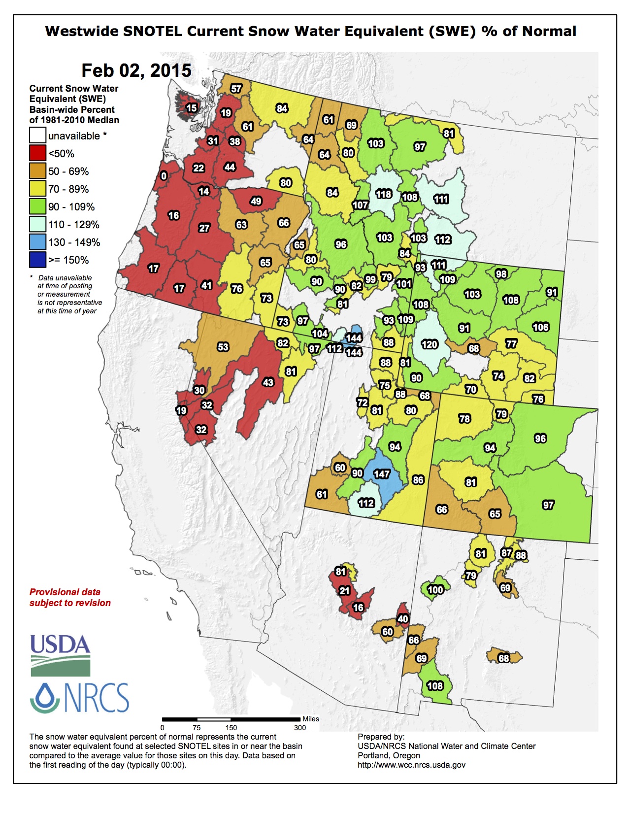
    Snowpack news: Aspen’s January one of the driest ever

    westwidesnotel02022015

    From The Aspen Times (Scott Condon):

    Aspen’s January snowfall was the second lowest amount for the month since 1935, according to the record keepers at the Aspen Water Treatment Plant.

    Only 5.26 inches of snow were recorded for the month, according to a report filed Monday by Laura Taylor.

    “Average snowfall for this month is 25.74 inches,” Taylor wrote. “This minimal snowfall is the second lowest recorded here since January 1935. Back in 1961, the lowest snowfall for January was recorded at 5.0 inches.

    The water treatment plant is on Doolittle Drive, near Castle Creek, at an elevation of 8,148 feet. Snowfall amounts at different locations around the Aspen metro area usually vary, but the water-treatment plant is the official National Weather Service station.

    The station’s records show Aspen has received less than 10 inches of snow in January only five times since 1935 prior to this year. There were 5 inches in 1961, 6.5 inches in 1974, 9.9 inches in 1981, 9.25 inches in 1985-86 and 7.75 inches in 2002-03…

    Joe Ramey, a forecaster and meteorologist for the National Weather Service in Grand Junction, said precipitation was a mixed bag for western Colorado in January. Durango enjoyed one-half inch above average in total precipitation for the month, and Grand Junction also was above average, he said. Below-average precipitation was more common, he said.

    “There’s been a big ridge just out to our west all of January,” Ramey said. “That ridge is really the culprit.”

    That ridge of high pressure deflected storms to the north and to the south of the Aspen area. In the short term, Aspen could pick up a few inches of snow over the next few days from a series of weak disturbances, Ramey said. A wet spring is forecasted in the desert southwest and into the Colorado Rockies during March and into April.

    “We’re hanging onto this wet spring” in the forecast, Ramey said.

    Despite the lack of snowfall in January, the Natural Resources Conservation Service’s automated weather station near the headwaters of the Roaring Fork River said the snowpack there was 109 percent of average Monday.

    Don Brown of Yuma named Commissioner of Agriculture

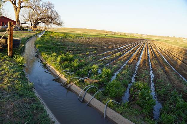
    Flood irrigation in the Arkansas Valley via Greg Hobbs

    From The Fort Morgan Times (Marianne Goodland):

    Gov. John Hickenlooper on Thursday named Don Brown of Yuma as Commissioner of Agriculture, effective Feb. 17. Brown replaces John Salazar, who retired earlier this month.

    Brown, a third-generation farmer in Yuma County, manages his family’s extensive farm operations, which include yearling cattle, irrigated corn and dryland farming. He is active in water conservation, energy development and technology innovation issues within the agricultural industry.

    Brown graduated from Yuma High School in 1973. He holds a degree in agriculture from Northeastern Junior College in Sterling, and received a vocational agriculture education degree with honors from Colorado State University.

    He is active in the National Cattlemen’s Association, Colorado Cattlemen’s Association, National Corn Growers and the Colorado Corn Growers Association. He has served as president of the Yuma County Cattlemen’s Association and state president of the Future Farmers of America…

    As commissioner, Brown will lead the department’s daily operations, direct its 300 employees, and oversee the agency’s seven divisions: Animal Health; Brand Inspection; Colorado State Fair; Conservation Services; Inspection and Consumer Services; Markets; and Plant Industry.

    In his first interview following the governor’s announcement, Brown told this reporter that as commissioner he will work to educate the general public about the role agriculture plays in their lives and to encourage young people to pursue agriculture as a career and way of life. “We take pride in providing safe food for everyone,” he said Thursday. But the public doesn’t understand something they haven’t been told about, so his job, and the department’s, is to explain how their food is produced and processed, and that the agriculture industry is interested in everything remaining safe.

    He pointed out recent trends that show young people coming back to rural communities, whether to engage in farming or ranching or agribusiness pursuits. “People have to eat, and it becomes our responsibility to feed them. That naturally leads to young people being involved, whether in technology, agribusiness or rural education,” he explained. “We have to keep rural communities healthy.”

    Brown also plans to be pro-active on water conservation issues. “We need to make the general public aware that the water we use, we don’t waste,” he said. Being pro-active on water means using it wisely, and most farmers and ranchers try to do that. Brown explained. It doesn’t mean not using it at all…

    The Senate Agriculture, Natural Resources and Energy Committee will be tasked with reviewing Brown’s nomination, and it will be up to Sonnenberg as its chair to marshal the confirmation through the Senate. Sonnenberg indicated he expects the confirmation to go smoothly and quickly.

    From The Denver Post (Steve Raabe):

    Gov. John Hickenlooper has appointed Yuma County farmer Don Brown as Colorado’s Commissioner of Agriculture.

    Brown replaces John Salazar, who retired last month after serving in the role since 2011.

    Brown is a business owner and third-generation farmer. He has been active in water conservation, energy development and technology innovation within the agriculture sector.

    “Agriculture is a critical sector for our economy, contributing $40 billion and providing nearly 173,000 jobs annually,” Hickenlooper said in a statement. “Having Don at the helm, we know agriculture across Colorado will continue to grow.”

    Brown will lead the department’s daily operations and direct its 300 employees.

    “To be able to contribute to the industry which I have so greatly benefited from is incredibly rewarding,” Brown said. “I have lived the life of those who the commissioner is to serve and I am committed to doing all I can to see that the industry continues to grow and that farmers and ranchers have every opportunity to succeed.”

    Brown graduated with a degree in agriculture from Northeastern Junior College in Sterling, and received a vocational agriculture education degree with honors from Colorado State University.

    Lower Ark pushes to make the value of agriculture more prominent in the #COWaterPlan

    Arkansas River Basin via The Encyclopedia of Earth
    Arkansas River Basin via The Encyclopedia of Earth

    From The Pueblo Chieftain (Chris Woodka):

    Water that grows food also protects wildlife and provides fun for humans.

    So the district formed to protect water in the Arkansas Valley wants to make agriculture more prominent in the state water plan.

    The Lower Arkansas Valley Water Conservancy District will push for a plank in the Arkansas Basin Roundtable implementation plan to strengthen its commitment to farms.

    “It’s been a struggle to increase the awareness of the value of water,” said Beulah rancher Reeves Brown, who sits on both the Lower Ark board and the roundtable. “We’re emphasizing that the values of ag water go beyond just the economic value. It’s also water that you can raft, boat and fish on.”

    Brown said the roundtable just last week received the long-term plan from the Pikes Peak Regional Water Authority, which includes finding more water from the Arkansas River over the next 50 years.

    “The threat is out there,” Brown said.

    “There are benefits of ag water to recreation and the community, not just making food,” said Lynden Gill, chairman of the Lower Ark board.

    Jay Winner, general manager of the district, said a proposed statement should be accompanied by a way to measure the benefits of ag water to recreational and environmental uses.

    “There are a lot of warm and fuzzy statements (in the water plan),” Winner said. “We’re trying to make a statement that’s precise.”

    More Colorado Water Plan coverage here.

    Snowpack news

    Click on a thumbnail graphic for a gallery of snowpack data from the Natural Resources Conservation Service.

    Take an online course on the science behind climate in the Western US. Starts April 1.

    EPA: Today is World Wetlands Day!

    NASA launches satellite to track water, energy cycles by measuring soil moisture

    A series of incredibly rare photographs of North American Indian tribes in the 1900 — @DanielGennaoui

    https://twitter.com/DanielGennaoui/status/561770421121712128

    The dust detectives — High Country News

    Xinjiang Taklamkan Desert via VisitOurChina.com
    Xinjiang Taklamkan Desert via VisitOurChina.com

    Here’s an in-depth look at the science of dust and precipitation from Douglas Fox writing for the High Country News. Click through and read the whole article. Here’s an excerpt:

    Grass on the sand dunes dawdles in a breeze. The air drifting in from the Pacific Ocean is clear and cool on this gray February morning. But Kimberly Prather is not outside inhaling its salty tang. Instead, she stands in a windowless trailer parked behind the dunes, experiencing the air second-hand as it filters through a tangle of humming machines, tubes and wires.

    “It’s just clean, clean sea spray,” she says, peering at a graph on a monitor. The line is mostly flat, punctuated by several sharp peaks. “That’s sodium chloride,” she says pointing at one. Then, on another graph, she notes a set of jumbled peaks for silicon oxide, aluminum and sodium chloride. “This is dust mixed with sea salt,” she says — “a hint that the dust is coming from pretty far away.”

    The air may seem clear at Bodega Head, 40 miles up the coast from San Francisco — but thousands of particles smaller than red blood cells drift in each cubic foot. Some have traveled a single mile; others, thousands. Prather’s machine sniffs them one by one, with a precision that no human nose can match. Its laser vaporizes five or six per second, spattering their guts across an ion detector, producing the chemical barcodes she peruses. A digital tally twirls alongside, like an odometer, too quickly to read — over 4,600 particles vaporized so far this morning.

    Prather, an atmospheric chemist with the Scripps Institution of Oceanography at the University of California, San Diego in La Jolla, displays a similar frenetic energy as she narrates the second-by-second stream of chemical barcodes popping up on her machine. “That’s a really good one, a lot of magnesium,” she says to me — then, into her phone, “Sorry, I’m showing him data.”

    Cloistered in this compartment, glasses pushed back over curly brown hair, she is like a sibyl who can see far away, reading at a glance the stories told by each obliterated particle. She knows when a ship, invisible over the horizon, is burning dirty fuel by the trace of vanadium it leaves. Peaks for two isotopes of lithium, meanwhile, are “almost a ringer for Asia,” she says, indicating crushed coal incinerated by Chinese power plants. She knows these things because she has analyzed samples from hundreds of sources around the world.

    Prather has toured the Western U.S. with her machines too, visiting coastlines, mountains, farms and even the suburbs of Southern California, where she chased semi trucks down Interstate 215. Her work on airborne dust and particulates could help answer a question critical to the drought-prone West’s future: What causes a cloud to drop rain or snow? And why does one cloud weep uncontrollably, while 20 others shed hardly a tear?

    A cloud bulging above a mountain crest can hold several million pounds of water, but that water is divided into droplets too small to overcome the atmospheric updraft lifting them. Only rarely can liquid droplets grow large enough to fall on their own. Most of the time, they have to freeze into ice to achieve the kind of runaway growth — snowball, you might say — into something large enough to fall back to Earth as rain or snow. But freezing is harder than you might think. Never mind the 32 degree Fahrenheit freezing point that you were taught in school: Tiny water droplets can remain stubbornly liquid at temperatures as low as 20 or 30 degrees below zero, perched on a thermodynamic cliff.

    Scientists have long believed that the instigator that tips them over the edge, into becoming ice, hides somewhere within the microscopic flotsam floating in the air. They have searched for it for decades. Now, Prather and her colleagues are finally closing in on its identity.

    Ironically, this new information about the tiniest particles is changing our view of how the world works on a grand scale, revealing a vast network of airborne dust commerce that ties together far-flung parts of the globe. These connections have enriched the West’s soils and shaped its precipitation patterns for thousands of years. But human-driven global warming and pollution have already begun to alter them, with implications for everything from agriculture and drinking water supplies to the basic shape of Western ecosystems. “We don’t understand this complex, totally intertwined system,” says Prather. “But we need to understand it soon.” [ed. emphasis mine]

    […]

    TThat Asian dust triggers Western rain is a momentous discovery. Still, a major question remains: What exactly is it about this dust that triggers ice formation?

    The simplest explanation is that specific kinds of mineral crystals provide a good scaffold for water molecules to latch onto, as with Bernard Vonnegut’s silver iodide. Experiments published in 2013 show that one class, called K-feldspars, trigger ice especially well. Although K-feldspars comprise only a minor component of dust worldwide, they are consistently found in dust from the Taklamakan Desert.

    There’s likely more to it, though. Hitchhikers on the dust’s surface may play a key role. Back in the trailer at Bodega Head, a set of conspicuous peaks for carbon-nitrogen and carbon-nitrogen-oxygen catches Prather’s eye. “A biological marker,” she says, “a piece broken off a protein” — most likely the incinerated innards of a living cell that had been riding on the speck of dust she just zapped.

    Forty percent of the Asian dust she’s sampled over Wyoming and California contains such signs of life. Other scientists have found that desert microbes can survive transoceanic transport on grains of dust. The same traits that allow them to inhabit hot deserts also provide protection against the aridity and ultraviolet radiation of the upper atmosphere, an advantage that may allow them to ride the global dust train from one continent to new habitats on another.

    A few microbes even secrete proteins that nucleate ice — some even more potently than silver iodide. And scientists collecting ice-nucleating particles from snow in Montana have found that heating them to bacteria-killing temperatures or treating them with a bacteria-obliterating enzyme — processes that don’t alter mineral structures — sharply reduces their ability to create ice.

    But other, tinier vermin could be even more important — hitchhikers on the hitchhikers. Sometime after noon at Bodega Head, Prather leans close to inspect a barcode with a towering peak of phosphorous — a classic signature for something containing lots of DNA and not much else. “Oh, my goodness,” she says. “That was the viruses.”

    Any dust that is carrying bacteria is just as likely to carry these ubiquitous genetic parasites. And while bacteria have squishy membranes that may provide poor footing for water molecules — like stacking Legos on a waterbed — many viruses are sealed in rigid protein cases. Those cases are covered in a repeating tile pattern of positive and negative charges that water molecules might just latch onto with ease. “Maybe,” says Prather, “that pattern is magical.”