The Lake County Board of County Commissioners establish water enterprise

mountmassivegolfcoursegolfcolorado

From The Leadville Herald (Ryan Fitzmaurice):

The Lake County Board of County Commissioners officially established a water enterprise during a regular meeting on Tuesday, Jan. 3, allowing it to secure the county’s water deal with the Mount Massive Golf Course.

The two motions were pushed through Tuesday because it was Bruce Hix and Michael Bordogna’s last meeting as county commissioners, and there were worries about conflicts of interest related to the water enterprise for both incoming commissioners, Mark Glenn and Sarah Mudge.

The water enterprise serves as the legal mechanism from which the county can lease water to entities such as the golf course.

There are only two uses for which the county can lease water currently – to cover the evaporative loss of Hayden pond, and to help supply water the golf course.

Bordogna said the county expects there to be much greater use in the future due to further development in the county.

The county may return funds to the general fund from the enterprise, but may not take loans that are outside of current statutory loans to fund it.

The county will also be unable to levy taxes to create the water enterprise.

Video: #OrovilleDam emergency spillway repairs Feb 18th — @CA_DWR

Lake Oroville Spillways February 18, 2017

Rural fire districts receive fire fighting funds — @DouglasCountyCO

douglascounty

Here’s the release from Douglas County:

Five rural Douglas County fire protection districts that respond to incidents in the Pike National Forest area received needed funds to help them manage wildland fires, medical emergencies or structure fires.

These five fire districts were awarded $100,000 in federal funds by the Board of Douglas County Commissioners. The districts will use the money over the course of the year to update wildland fire equipment, purchase new rescue equipment, pay for training and improve their communication mechanisms.

“Volunteers and staff from these fire districts are often the first responders on an incident in the Pike National Forest,” said Douglas County Commissioner and Board Chair Roger Partridge. “Consistent with the Board of County Commissioners Public Safety priority, we work in partnership with these districts as we prepare for and respond to incidents within Douglas County. We recognize how important this funding is to their ability to protect and serve.”

Money was distributed to the five agencies, based on the number of calls they made during the year, at an average of $675 per call. Awards were as follows:

  • Jackson 105 Fire Protection District: $21,620 (32 calls)
  • Larkspur Fire Protection District: $4,745 (7 calls)
  • Mountain Communities Volunteer Fire Protection District: $29,045 (43 calls)
  • North Fork Fire Protection District: $22,295 (33 calls)
  • West Douglas Fire Protection District: $22,295 (33 calls)
  • Douglas County — like many other local governments that have non-taxable federal lands within their boundaries — receives a Payment in Lieu of Taxes (PILT) annually from the federal government to help offset losses in property taxes spent on the utilization of County services on non-taxable federal lands.

    Beginning in 2002, Douglas County designated a portion of its PILT money to provide supplemental funding for the five rural fire districts.

    Upper #ColoradoRiver Basin precip. A-OK so far #COriver

    Water Supply Forecast Colorado River Basin February 18, 2017. Credit Colorado River Forecast Center
    Water Supply Forecast Colorado River Basin February 18, 2017. Credit Colorado River Forecast Center

    From The Los Angeles Times (William Yardley):

    …there is one place where the precipitation has been particularly welcome and could be transformative: the Colorado River basin, which provides water to nearly 40 million people across seven states.

    “We’re in a really good spot as far as snow accumulations,” said Malcolm Wilson, who leads the Bureau of Reclamation’s water resources group in the upper Colorado River basin.

    Under federal guidelines that kick in when water flows reach certain volumes, the Bureau of Reclamation, which oversees the river basin’s largest reservoirs, Lake Powell and Lake Mead, could release enough water from the former to raise the elevation of the latter by 20 feet or more — providing a remarkable shot in the arm for a lake that has been declining steadily during a devastating drought that started in 2000.

    The process — lowering one reservoir to lift another — is called equalization, and a few weeks ago, it was not even viewed as a viable option. Now, Wilson said, “It’s in the realm of possibility.”

    Even if that optimistic scenario does not play out — the region would need several more weeks of strong precipitation without a substantial warmup — there is still reason to savor a moment of relief on the Colorado…

    As of last month, the bureau was forecasting about a 50% chance that, for the first time, the river and its reservoirs would not be able to fulfill the water demands of states that rely on it, beginning in 2018.

    But this week, the bureau quietly updated that forecast, saying the chance was only about 34%. By the end of this year, it expects Lake Mead to be at least 3 feet above the threshold at which an official “shortage” would be declared.

    Not only that, the bureau said the likelihood of a shortage through 2021 is no greater than 33%. Just a few weeks ago, the chances of shortages in that time frame were about 60%.

    Rio Grande Reservoir outlet works project update

    Rio Grande Reservoir
    Rio Grande Reservoir

    From The Pueblo Chieftain (Matt Hildner):

    The reservoir’s outlet experiences what Smith calls a “hydraulic jump” because of a design flaw that allows air to surge along the ceiling of the tunnel. “It’s kind of a coke bottle affect,” said Smith, who also represents the Rio Grande basin on the conservation board. That flaw has limited the amount of water that can be released from the reservoir during periods of high inflows to 1,200 cubic feet per second. Smith hopes the repairs will boost that figure to between 1,800 CFS and 2,000 CFS. State lawmakers initially approved other repairs to the reservoir as part of the $30 million Rio Grande Cooperative Project in 2012. The current proposal would add another $10 million to that initial approval, although lawmakers would decide how much of that amount is grant or a loan…

    Smith sees that cooperation between privately-owned irrigation reservoirs and other interests on the river as a model for advancing water projects.

    The reservoir’s main purpose is to deliver irrigation water to just 62,000 acres of farm ground in the north end of the San Luis Valley. With a capacity of 54,000 acre-feet, it is one of only three reservoirs with significant capacity upstream from where diversions begin to pull from the river for agriculture. That means it plays an important role in replacing depletions on lower reaches of the river caused by groundwater pumping on the valley floor.

    Pueblo West contracts for 6,000 acre-feet of storage in Lake Pueblo

    Pueblo West
    Pueblo West

    From The Pueblo West View (Kristen M. White):

    Pueblo West will have the right to store water in Pueblo Reservoir in the future, should the storage be needed, after the Metropolitan District agreed to enter into a subcontract with the Southeastern Colorado Water Conservancy District…

    The master plan contract is between the Bureau of Reclamation and the water district, and Pueblo West now has a subcontract with water district for its storage rights.

    The contract allows Pueblo West to begin paying for 10 acre feet, at the starting rate of $40.04 per acre foot of water, in 2017. But the contract gives Pueblo West the ability to store as much as 6,000 acre feet of water in the future should the storage ability be necessary.

    Second Circuit: Water transfer ruling in favor of EPA’s rule that trans-basin diversions do not require a federal NPDES permit under the CWA

    newyorcitywatersupplysystem

    From email from Greg Hobbs:

    [Here] is the Second Circuit’s water transfer ruling issued [January 18, 2017] in favor of EPA’s rule that trans-basin diversions do not require a federal NPDES permit under the Clean Water Act..

    Colorado has long taken the position that trans-basin diversions do not require such a permit.

    Click here to read the decision.

    #Snowpack news: Rio Grande doing well for a change

    Westwide basin-filled map February 19, 2017 via the NRCS.
    Westwide basin-filled map February 19, 2017 via the NRCS.

    From The Valley Courier (Ruth Heide):

    Colorado Division of Water Resources Division 3 Engineer Craig Cotten explained that both the Rio Grande and Conejos River systems, which are under Rio Grande Compact obligations to New Mexico and Texas, are forecasted for above average flows . The snowpack in the Rio Grande Basin that encompasses the Valley is also above average.

    More water is good news, Cotten said, but it also means more water must be sent down the river to meet the compact. He explained that the greater the flow, the higher the percentage that must be sent downriver.

    That also means irrigators will see higher curtailments on the river systems affected by the compact, Cotten added.

    Cotten updated the Rio Grande Roundtable members on the Valley’s river and snowpack status on Tuesday. His early forecast for the annual flow of the Rio Grande at Del Norte is 795,000 acre feet, 124 percent of the long-term average. That is higher than the Natural Resources Conservation Service’s (NRCS) current forecast, which is about 700,000 acre feet, Cotten said, but he believed the runoff would be higher.

    He said his office is using multiple sources such as the NRCS and National Weather Service to develop forecasts.

    If the forecast of 795,000 acre feet holds true on the Rio Grande, Colorado will be obligated to send 254,000 acre feet downstream to meet its compact obligations.

    In order to do that, ditches along the Rio Grande would have to be curtailed by about 27 percent. In comparison, last year curtailments were at 12 percent at the beginning of the irrigation season, Cotten said.

    Curtailments on the Conejos River system will be even higher, according to Cotten. He said the NRCS is currently forecasting an annual index flow of 420,000 acre feet, about 137 percent of the longterm average, which would require 206,000 acre feet to be sent downstream to meet compact obligations.

    That would require a curtailment of 43 percent, Cotten explained…

    As of Tuesday the snowpack in the Rio Grande Basin was 148 percent of average, Cotten said. Some of the snow measurement (SNOTEL) sites were well above that. For example, Costilla and Culebra Creeks’ SNOTEL sites were at 177-178 percent of average, and the Valley’s highest was Sangre de Cristo Creek at 184 percent.

    #OrovilleDam: How much rain will fall on the Feather River watershed? Will the emergency channel lining hold?

    Well it’s going to rain like hell tomorrow over the Feather River watershed.

    screen-shot-2017-02-19-at-7-23-02-am

    screen-shot-2017-02-19-at-7-26-25-am

    screen-shot-2017-02-19-at-7-27-37-am

    screen-shot-2017-02-19-at-7-35-45-am

    screen-shot-2017-02-19-at-7-37-47-am

    screen-shot-2017-02-19-at-7-39-18-am

    screen-shot-2017-02-19-at-7-41-24-am

    screen-shot-2017-02-19-at-2-08-26-pm

    And California DWR has been lining the channels and the headwall cuts below the emergency spillway.

    Oroville dam site emergency spillway repairs February 17, 2017 via CA DWR.
    Oroville dam site emergency spillway repairs February 17, 2017 via CA DWR.

    screen-shot-2017-02-19-at-11-54-47-am

    And working on the Feather River below the spillway outfall.

    screen-shot-2017-02-19-at-7-28-43-am

    screen-shot-2017-02-19-at-7-29-52-am


    screen-shot-2017-02-19-at-7-30-55-am

    Finally, here’s a model of the extent of the possible flood:

    Report: The 21st century #ColoradoRiver hot #drought and implications for the future #COriver

    Photo via Brent Gardner-Smith/Aspen journalism
    Photo via Brent Gardner-Smith/Aspen journalism

    Click here to buy the report. Here’s the abstract:

    Between 2000 and 2014, annual Colorado River flows averaged 19% below the 1906-1999 average, the worst 15-year drought on record. At least one-sixth to one-half (average at one-third) of this loss is due to unprecedented temperatures (0.9°C above the 1906-99 average), confirming model-based analysis that continued warming will likely further reduce flows. Whereas it is virtually certain that warming will continue with additional emissions of greenhouse gases to the atmosphere, there has been no observed trend towards greater precipitation in the Colorado Basin, nor are climate models in agreement that there should be a trend. Moreover, there is a significant risk of decadal and multidecadal drought in the coming century, indicating that any increase in mean precipitation will likely be offset during periods of prolonged drought. Recently published estimates of Colorado River flow sensitivity to temperature combined with a large number of recent climate model-based temperature projections indicate that continued business-as-usual warming will drive temperature-induced declines in river flow, conservatively -20% by mid-century and -35% by end–century, with support for losses exceeding -30% at mid-century and -55% at end-century. Precipitation increases may moderate these declines somewhat, but to date no such increases are evident and there is no model agreement on future precipitation changes. These results, combined with the increasing likelihood of prolonged drought in the river basin, suggest that future climate change impacts on the Colorado River flows will be much more serious than currently assumed, especially if substantial reductions in greenhouse gas emissions do not occur.

    Here’s a report from John Fleck writing for InkStain. Here’s an excerpt:

    A warming climate is already reducing the flow in the Colorado River, and the future risk is large, with a worst case of the river’s flow being cut in half by the end of the century, according to a new study from a pair of the region’s leading researchers. While precipitation declines since the turn of the century have been modest, Brad Udall and Jonathan Overpeck found, a little less rain and snow have translated to a lot less water in the river.

    @FortCollinsGov NISP meeting recap

    Northern Integrated Supply Project (NISP) map July 27, 2016 via Northern Water.
    Northern Integrated Supply Project (NISP) map July 27, 2016 via Northern Water.

    From The Fort Collins Coloradoan (Kevin Duggan):

    City staff members have proposed beginning in-depth discussions with Northern Water to explore areas of “mutual interest” and possibly negotiate an agreement. City Council would have to approve any agreement, if one were reached.

    Discussions with Northern Water, if approved by council, would be lengthy and touch on “endlessly complicated” details, said John Stokes, director of the city’s Natural Areas Department.

    Fort Collins is not among the 15 municipalities and water districts participating in NISP, though as a stakeholder it has been involved with the project’s permitting process for many years.

    In 2008 and 2015, the city submitted comments critical of the project to the U.S. Army Corps of Engineers, which is overseeing the Environmental Impact Statement process for NISP.

    The Corps and other state and federal agencies will be involved in determining mitigation measures for NISP, which would reduce flows on the Poudre through the city 20 percent a year on average and 30 percent during peak flows in spring.

    Experience tells the city it cannot rely on other entities to look out for the best interests of Fort Collins in assessing the negative impacts of NISP through town, Stokes said during a recent city-sponsored open house.

    “They are not likely, in our view, to require mitigation at a level that we think would be important to the city if we didn’t negotiate,” Stokes said…

    The final Environmental Impact Statement, or EIS, for the project is expected to be released by the Corps later this year. A record of decision on whether the project may be permitted is expected in 2018.

    If the project is permitted, construction could begin in 2025, city officials say.

    Discussions and negotiations between the city and Northern Water would be outside of the permitting process, said John Urbanic, project manager with the Corps of Engineers…

    Mitigation of environmental impacts are part of the permitting process. It’s possible a mitigation agreement between the city and Northern Water could be included in the permit, Urbanic stated in an email to the Coloradoan.

    Whether an agreement would facilitate a permit being issued “depends on what’s in the agreement,” he said.

    Fort Collins’ focus regarding NISP is on the area crossed by the river between the mouth of the Poudre Canyon and Interstate 25. The city owns several natural areas along the river corridor.

    Stokes said the city has many concerns about the impacts of lowering baseline and peak flows on the Poudre, including:

  • Reduced water quality and additional stresses on city water treatment facilities
  • Reductions in the health of the river’s ecology and biological resources
  • Reductions in the river’s ability to convey flood water
  • Diminished recreation and aesthetics
  • Specifics of what city staff would seek from Northern Water through negotiations and what it might have to do in return have not been determined, Stokes said.

    About 200 people attended a city-sponsored open house on the issue Monday at the Lincoln Center. Longstanding opponents and proponents of NISP were on hand, stating familiar positions.

    Will water get too expensive for some Americans? – News on TAP

    Denver falls well below the national average but faces the same infrastructure costs that drive up bills nationwide.

    Source: Will water get too expensive for some Americans? – News on TAP

    The tunnel (next to the tunnel) that no one knows – News on TAP

    One brings trains through the Rockies. The other has been delivering much-needed water for 80 years.

    Source: The tunnel (next to the tunnel) that no one knows – News on TAP

    Fountain of youth in Eleven Mile Canyon – News on TAP

    Still strong and sturdy, Denver Water’s second-largest reservoir turns 85 in 2017.

    Source: Fountain of youth in Eleven Mile Canyon – News on TAP

    On Drought and the “Drought Contingency Plan”: A conversation with Water Resources Director Tom Buschatzke about the on-going, multi-state struggle to save Lake Mead

    @NASAClimate: SnowEx — space-based SWE estimation

    SnowEx aircraft, February 17, 2016.
    SnowEx aircraft, February 17, 2016.

    Snowex is hoping to determine how to measure the effect of the tree canopy on snowpack, snow depth, and snow density, all from space. This is the first year for SnowEx and is an intense data collection phase. An airplane is used as a proxy for satellite observations during this phase which also includes a ground effort on Grand Mesa (forest canopy site) and in the Senator Beck Basin (high altitude alpine site).

    The team will spend next year examining the data and hoping to model a combination of sensors (multi-sensor approach) that correlates with the ground data sites. Edward Kim (NASA) called this, “ground-truthing.”

    Years 3, 4, and 5 are lined-out for more data collection.

    The other two speakers, Karl Wetlaufer (NRCS), and Frank McCormick (USFS), spoke about current snowpack estimation methods, the importance of estimation of the tree canopy effect, and the potential benefits of SnowEx.

    Kim listed the benefits:

    1. Water is critical to society — the project aims to measure the water in the snowpack to estimate runoff.

    2. Forecast the potential for snowmelt floods — (9 of the most devastating floods in US history were snowmelt driven). Forecast drought.

    3. For national security reasons it is important to know who has snow, and therefore water supply.

    4. Forecast changes in climate.

    Wetlaufer explained the science behind current snowpack estimation efforts. SNOTEL sites include a snow pillow to weigh the snow and the Federal Snow Sampler is used by the snow survey crews.

    Snow surveys have always been a cooperative effort in the water community, he explained, citing participation by ditch companies, the NRCS, municipal providers, and others. Federal funding fired up in 1934.

    Rani Gran (NASA) said that the science was at the frontier of snow science.

    President Theodore Roosevelt
    President Theodore Roosevelt

    Frank McComick said that the USFS has been the lead agency concerned with snow water equivalent for over a century. In the West, he said, 80% of water supply comes from snowmelt from forested mountain areas.

    He talked about the difficult and exacting work going on by the 100 or so ground folks including digging snow pits, from the surface to bare ground, with hand tools. At times the temperatures are well below zero. He said work in the Senator Beck basin was suspended earlier this week due to 60mph winds and white-out conditions, even though it was not snowing at the time. The field crews have been working since February 6th and plan to end the field work on the 20th.

    I really liked talking to the Navy crew.

    The survey requires low-level flying over the mountains. One of the pilots talked about the Rockies and how she was psyched at the chance to catch some of the views.

    The other pilot was enthusiastic about his role on the team, helping the scientists aboard the aircraft accomplish their goals.

    Oroville, the aerospace engineering program at CU, water rights, Colorado’s position as a the “Headwaters State”, the flood of September 2013, and how mountains concentrate streamflow, all came up in my conversations with the team members.

    Thanks to Rani for organizing the event.

    Click on a thumbnail graphic below to view a gallery of photos from the event.

    @NASAClimate Investigates Water Supply in Snow

    snowexadvisorynasa

    I’m heading down to Petersen AFB to learn about this project this today. Here’s the release from NASA:

    This February, a NASA-led research campaign called SnowEx kicked off in Colorado. The 5-year study will advance global measurements of how much snow is on the ground at any given time and how much liquid water is contained in that snow. The amount of water in snow plays a huge role in water availability for drinking water, agriculture, and hydropower.

    Teams of 50 researchers are stationed at Grand Mesa and Senator Beck Basin over a three-week period to measure snow using a variety of snow-sensing instruments and techniques. Ground measurements will allow the team to validate the remotely sensed measurements acquired by multiple sensors on the various aircraft.

    Data acquired from the SnowEx campaign will be stored at the National Snow and Ice Data Center in Boulder, Colorado, and will be available to anyone to order at no cost, as is the case with all NASA data.

    For more information: https://www.nasa.gov/earthexpeditions/

    2017 #COleg: Colorado Corn backs SB17-036 (Appellate Process Concerning Groundwater Decisions)

    Groundwater movement via the USGS
    Groundwater movement via the USGS

    From the Colorado Corn Growers Association (Eric Brown):

    During a meeting this month, the Colorado Corn Growers Association’s Public Policy Committee voted to put its support Senate Bill 17-036, a measure titled, “Appellate Process Concerning Groundwater Decisions.”

    Under current law, the decisions or actions of the ground water commission or the state engineer regarding groundwater are appealed to a district court, and the evidence that the district court may consider is not limited to the evidence presented to the commission or state engineer.

    Therefore, unlike appeals from other state agencies’ decisions or actions under the “State Administrative Procedure Act,” a party appealing a decision or action of the commission or state engineer may present new evidence on appeal that was never considered by the commission or state engineer.

    This bill would limit the evidence that a district court may consider when reviewing a decision or action of the commission or the state engineer on appeal to the evidence presented to the commission or the state engineer.

    While this is the first bill on which the CCGA Public Policy Committee has taken a position, the committee is monitoring a number of others as the 2017 Colorado Legislative Session continues.

    #Snowpack news: Several basins measure above normal peak

    Click on a thumbnail graphic to view a gallery of snowpack data from the NRCS.

    Here’s the Westwide Basin-Filled snowpack map for February 17, 2017.

    Westwide SNOTEL basin-filled map February 17, 2017 via the NRCS.
    Westwide SNOTEL basin-filled map February 17, 2017 via the NRCS.

    Pueblo Dam hydropower plant should be online next year

    Pueblo dam releases
    Pueblo dam releases

    From KOAA.com (Andy Koen):

    The Pueblo Dam will soon be producing enough renewable energy to power 3,000 homes. The Southeastern Colorado Water Conservancy District plans to begin construction of the $19.5 million hydroelectric generating station later this year. The construction site will be located downstream form the Pueblo Dam River Outlet which was constructed to serve as the connection for the Colorado Springs Utilities Southern Delivery System.

    “We’ll be using the water that’s flowing into the river again, we won’t be consuming any of that water,” explained Conservancy District spokesman Chris Woodka.

    The District borrowed $17 million from the Colorado Water Conservation Board to build the plant. It will house a trio of turbines, each capable of producing electricity whether the river is moving fast or slow.

    “We designed it so that it would at several different flows so that we could get the maximum production out of it,” Woodka said.

    With a rating of 7.5 megawatts, the plant will create enough power for roughly 3,000 homes. It’s the kind of clean power that City leaders in Pueblo want for their community…

    The Conservancy District expects to generate around $1.4 million annually from the sale of it’s electricity. Groundbreaking is expected to take place in May and Woodka said their goal is to have the power plant go online in the Spring of 2018.

    Lower South Platte Water Conservancy District board meeting recap

    Northern Integrated Supply Project (NISP) map July 27, 2016 via Northern Water.
    Northern Integrated Supply Project (NISP) map July 27, 2016 via Northern Water.

    From The Sterling Journal-Advocate (Jeff Rice):

    The Lower South Platte Water Conservancy District’s board of directors decided Tuesday to not object to a plan to move the proposed Galeton Reservoir from its original site.

    Galeton is part of the Northern Colorado Water Conservancy District’s controversial Northern Integrated Supply Project, which would use water from the Cache la Poudre and South Platte rivers to irrigate, provide domestic water, and bolster the Poudre through Fort Collins.

    Northern Water originally planned to build the reservoir on the southeast side of Colorado Highway 14 near Galeton, but in the 10 years since the project was proposed Nobel Energy has drilled almost two dozen oil and gas wells in the area. Those wells would have to be capped, at tremendous cost to Northern, in order to use the site for a reservoir.

    Northern has applied to have the water rights instead transferred to land on the northwest side of the highway.

    LSP board member Brad Stromberger, who also is on the Northern board of directors, said the Berthoud-based water district is “in the design stages” on the project already and plans to begin construction on the reservoir within about five years.

    “This is a big project,” he said. “This is a new water source we need.”

    The LSP’s water lawyer, Kim Lawrence, had recommended that the district file an objection to Northern’s request. Such objections are commonplace primarily to get access to crucial engineering and financial information about water projects. LSPWCD has previously gone on the record as being entirely in support of NISP, and during Tuesday’s meeting the district’s manager, Joe Frank, cautioned that objecting to the change in the Galeton application could be used by NISP opponents to claim that the lower South Platte doesn’t support NISP.

    “We could, potentially, see about 10,000 acre feet of return flow per year from this project,” Frank told the board. “There might be a day here and there when they would take water that might have come down (the South Platte River) but the return flows will more than make up for that.”

    After a brief conference call with Lawrence, the board decided to not take any action on the Galeton Reservoir…

    The board did, however, vote to file an objection to an application by the Arapahoe County Water and Wastewater Authority to pipe 1,500 acre feet of water from the South Platte River into the off-channel Binder Reservoir, also known as the Brighton Lateral Reservoir. ACWWA wants to use the water to exchange with other water entities along the river. Lawrence’s recommendation to the LSP was to file an objection because the proposed project “affects many (irrigation) ditches in this reach.”

    Fountain Creek: Pueblo County and Lower Ark join @EPA/CDPHE lawsuit

    From The Colorado Springs Gazette (Billie Stanton Anleu):

    Pueblo County commissioners and the Lower Arkansas Valley Water Conservancy District can intervene in the suit, U.S. District Judge Richard P. Matsch ruled Thursday.

    A year ago, Pueblo County commissioners signed off on an intergovernmental stormwater agreement with Colorado Springs, ensuring that the city will spend $460 million over 20 years to provide 71 stormwater projects aimed at minimizing Fountain Creek’s effects on downstream communities.

    The creek flows downstream carrying excess sedimentation, E. coli contamination and other pollution, claims the Lower Ark, which represents the largely agricultural areas of Bent, Crowley, Otero, Prowers and Pueblo counties.

    County officials have echoed those concerns.

    And the EPA, after conducting audits in 2013 and 2015 of the city’s stormwater system, found that the creek and its tributaries were eroded and widened, their waters combining with surface runoff to create excessive sedimentation and substandard water quality.

    Federal officials upbraided the city for not demanding enough infrastructure from developers and for not maintaining the culverts and creeks snaking through the city.

    The lawsuit, filed by the U.S. Department of Justice on the EPA’s behalf, and by the Colorado Department of Public Health and Environment, is a serious concern for Mayor John Suthers, who has made the city’s long-neglected stormwater infrastructure a top priority.

    In addition to the agreement with Pueblo County, he has more than doubled the stormwater division’s staff, added a new manager and overseen the Nov. 2 release of an inch-thick Stormwater Program Implementation Plan.

    The EPA and state filed suit one week later, on Nov. 9.

    From The Pueblo Chieftain (Anthony A. Mestas):

    Pueblo County was granted a motion Thursday that allows the county to join in a federal/state lawsuit against the city of Colorado Springs.

    The Lower Arkansas Valley Water Conservancy District also was allowed to join the case as an intervenor to protect the district’s interest during the litigation…

    Pueblo County filed the motion to intervene last week. The lawsuit was filed Nov. 9 in U.S. District Court in Denver by the Environmental Protection Agency and the Colorado Department of Public Health and Environment against Colorado Springs.

    The Lower Ark district filed the same motion in November.

    The lawsuit claims there is harm caused by discharges of pollutants down Fountain Creek into Pueblo and east to the Arkansas River’s other tributaries.

    It also claims the city of Colorado Springs made numerous violations of their Municipal Separate Storm Sewer System permit issued by the state.

    Alleged violations by Colorado Springs include the failure to adequately fund its stormwater management program, to properly maintain its stormwater facilities and to reduce the discharge of pollutants to the maximum extent practicable.

    Hart and fellow Commissioners Sal Pace and Garrison Ortiz have said they cherish the relationship the county has developed with Colorado Springs through negotiations over the Southern Delivery System’s 1041 permit agreement and hope this will not do anything to damage it.

    The Fountain Creek Watershed is located along the central front range of Colorado. It is a 927-square mile watershed that drains south into the Arkansas River at Pueblo. The watershed is bordered by the Palmer Divide to the north, Pikes Peak to the west, and a minor divide 20 miles east of Colorado Springs. Map via the Fountain Creek Watershed Flood Control and Greenway District.
    The Fountain Creek Watershed is located along the central front range of Colorado. It is a 927-square mile watershed that drains south into the Arkansas River at Pueblo. The watershed is bordered by the Palmer Divide to the north, Pikes Peak to the west, and a minor divide 20 miles east of Colorado Springs. Map via the Fountain Creek Watershed Flood Control and Greenway District.

    January was 3rd warmest on record for the globe — @NOAAClimate

    Here’s the release from NOAA:

    February 16, 2017 If the climate records of late 2016 were any indication, January 2017’s balmy global temperatures — and record-small polar ice extents — will come as no surprise.

    January’s average global temperature was 1.58 degrees F above the 20th century average of 53.6 degrees, according to the analysis by scientists from NOAA’s National Centers for Environmental Information. This was the third highest for January in the 1880-2017 record, behind 2016 (highest) and 2007 (second highest).

    significantclimtaeevents012017noaa

    More noteworthy findings for January included:

  • Record-low sea ice extent at the poles
  • The average Arctic sea ice extent was 8.6 percent below the 1981-2010 average for January, and the average Antarctic sea ice extent was 22.8 percent below the 1981-2010 average. For both regions this was the smallest January sea ice extent since the satellite record began in 1979.
    Above-average snow cover in the Northern Hemisphere
  • The Northern Hemisphere snow cover extent was the sixth largest in the 51-year period of record. North America had its 13th largest and Eurasia had its seventh largest.
  • Warmer-than-average lands and oceans

  • The globally averaged sea surface temperature was the second highest January on record, 1.17 degree F above average.
  • The globally averaged land surface temperature was the third highest January on record, 2.77 degrees F above average.
  • Continents experienced temperature highs and lows

  • North America had its fourth warmest January on record; South America had its second; Asia tied as sixth; Oceania had its 13th; and Africa had its 21st. Cooler-than-average conditions engulfed much of Europe in January, which had its coldest winter since 2010.
  • #Drought news: D1 extended in Yuma, Washington, and Logan counties, D0 expanded in Weld county

    Click here to go to the US Drought Monitor website. Here’s an excerpt:

    Summary

    During this U.S. Drought Monitor week, storms continued to impact the west, including parts of California, bringing more heavy precipitation to much of the region, as snow packs continued to increase and reservoirs continued to fill. Fortunately a respite from the storms came toward the latter half of the week. On the other side of the country, a strong low pressure system impacted much of the eastern United States, bringing heavy snowfall to central and northern New England on the 9th. Another nor’easter impacted the area on the 12th-13th. Meanwhile, an upper-level low over northern Mexico, along with a surface frontal boundary, resulted in rain and mountain snow from Arizona to western Texas. Precipitation spread across Texas to Oklahoma on the 12th-13th. Not all regions received rainfall. Much of the southeast continued to receive below-normal precipitation while record high temperatures spread across the south during the 11th-12th…

    The Plains

    Snowpack around 60 percent of normal as of early February led to the introduction of abnormally dry conditions (D0) in part of central Montana from northern Meager to south and central Fergus counties. In eastern Colorado, moderate drought conditions (D1) were extended to northwest Yuma County, northern Washington County, and southeast Logan County. This area has received below 50 percent of normal precipitation since the beginning of October, and recent weather has been hot and windy. The winter wheat also appears to be in poor condition. Additionally, abnormally dry (D0) conditions were expanded to the northern border of Colorado in Weld County…

    The West

    Storms continued to drop heavy precipitation over parts of California, leading to widespread improvements of the multi-year drought in the state, although some pockets have missed out on the precipitation and water restrictions remain due to low reservoir levels. A few large–scale improvements were made in central and southern California. Drought conditions improved in Monterey and eastern Santa Clara Counties. Western Monterey and most of Santa Clara County are now drought free. Improvements were also made across the San Joaquin Valley, with snowpack well above 100% in the Sierras. Reservoirs are being replenished across most regions. At the foot of the Sequoia National Forest, Lake Isabella’s water level increased 20 percent. Further south, drought conditions broadly improved across San Bernardino and southern Inyo counties. However, Death Valley remains in moderate drought (D1) as the area has received just 35% of its normal precipitation for the water year to-date…

    Looking Ahead

    The NWS WPC 7-Day Quantitative Precipitation Forecast (QPF) calls for much more heavy precipitation to impact the west, from Washington all the way to southern California, with an area in northwestern Washington forecast to receive as much as 10.8 inches of precipitation. Overall wide swaths are expected to receive well over two inches of rainfall. Rainfall may also impact southern Texas. Moving eastward, much of the southeast is forecast to see a quarter to a little over an inch of rain over the seven-day period. Once again, central and northern New England may see heavy moisture during the week, with the heaviest amounts projected over northern New Hampshire. The CPC 6–10 day outlooks call for a high probability of above-normal temperatures across the eastern two-thirds of the United States, and below-normal temperatures forecast to prevail in the west. Below-normal precipitation is forecast for a swath in the southwest covering Arizona, New Mexico, and central to western Texas while above-normal precipitation is expected most everywhere else in the contiguous U.S. Northern Alaska is also expected to receive above average precipitation and below-average temperatures during the period, while the southern tier is forecast to be warmer than average.

    The “E-Waternews” is hot off the presses from @Northern_Water

    The Bear Lake SNOTEL (Big Thompson watershed) site's normal peak is 18.6 inches of snow water equivalent. As of Feb. 15, the site was reporting 20.4 inches of SWE. This is above the normal peak, with two additional snow accumulation months to go.
    The Bear Lake SNOTEL (Big Thompson watershed) site’s normal peak is 18.6 inches of snow water equivalent. As of Feb. 15, the site was reporting 20.4 inches of SWE. This is above the normal peak, with two additional snow accumulation months to go.

    Click here to read the news. Here’s an excerpt:

    Snow, snow and more snow

    Thank you, January. Numerous storms last month provided much-needed precipitation in Colorado’s mountains. As a result, all eight of the watersheds monitored by Northern Water currently have above-average snow water content, and the most probable streamflow forecasts are also well above average.

    As of Feb. 14, statewide snowpack was 147 percent of normal. And the two major river basins Northern Water monitors for its forecasts, the Upper Colorado and South Platte basins, were at 147 and 142 percent of normal, respectively.

    Beginning each February, Northern Water’s Water Resources Department releases monthly snowpack and streamflow forecasts. The forecasts provide:

  • Snow water content comparisons in the eight watersheds Northern Water monitors
  • April through July maximum, minimum and most probably streamflow forecasts
  • C-BT Project storage also remains above average for this time of year. On February 1, active storage in the project was 530,331 acre-feet, or 121 percent of normal.

    Big-Picture Questions Raised by the Oroville Dam Emergency — Water Deeply

    Water from the Oroville Dam auxiliary spillway has eroded the roadway just below the spillway. Photo courtesty of Kelly M. Grow/ California Department of Water Resources.
    Water from the Oroville Dam auxiliary spillway has eroded the roadway just below the spillway. Photo courtesty of Kelly M. Grow/ California Department of Water Resources via @circleofblue.

    From Water Deeply (Laura Feinstein, Peter Gleick):

    Let’s not let a good crisis go to waste: Here are six important conversations that need to happen in the aftermath of problems at Oroville Dam in Northern California.

    A critical question is whether the main spillway will be serviceable for the remainder of the winter. Dam managers must continue to release water down the damaged main spillway to maintain flood space behind the dam for coming storms and spring snowmelt. Bill Croyle, acting director of DWR, told the Sacramento Bee this past Sunday that his agency is not seeing further erosion of the main spillway at current flow levels of 100,000 cubic feet per second (cfs). Managers also shut down the turbines at the base of the dam that normally release up to 15,000 cfs because of downstream obstructions.

    If another storm sends water into Oroville Lake faster than it can be released via the turbines and main spillway, then water could again over flow the concrete wall that forms the top of the emergency spillway. If the hillside beneath erodes further, this wall could collapse or be undermined, sending massive amounts of water downstream causing damaging, life-threatening floods.

    Sacramento Bee has a concise recap of events here.

    Can We Prevent These Types of Dam Crises in the Future?

    It’s well-documented that the United States has chronically underfunded dams, levees, drinking water and wastewater infrastructure for years. The Association of State Dam Safety Officials estimates the cost of known needed repairs for the country’s 2,000 deficient, high-hazard dams at $21 billion. Drinking water, wastewater, waterways, ports and levees need repairs too. The American Society of Civil Engineers in a 2013 report put the unmet funding needs of our water infrastructure at $187 billion by 2020 (calculated in 2010 dollars).

    Had the emergency spillway been lined with concrete, as was recommended in a motion filed by Friends of River, Sierra Club and South Yuba River Citizens League in 2005, it might have prevented the erosion that occurred this past weekend. In hindsight, it’s easy to see that this would have been a worthwhile investment compared to the cost of repairs, mass evacuations, and environmental impacts.

    But the Oroville spillway crisis reveals another important question we haven’t been asking about our underfunded infrastructure. That is: How much money do we need to budget for upgrades that are becoming necessary as engineering standards improve and climate change imposes greater pressures on the system? We may be on the hook for even more money than we realize.

    Where Are We Going to Get the Money to Repair the Spillways?

    Preliminary estimates to repair just the main spillway are in the range of $100m-$200m, according to Bill Croyle at DWR. The State Water Contractors that get their water from the State Water Project will likely have to pay for at least part of the repairs, and they will pass the costs on to their ratepayers. Three more things to note.

    First, these expenses are likely to cause increases in costs for ratepayers, some of whom are already struggling to pay their water bill. Second, we should expect a vigorous debate as to who else should help foot the bill. Should residents of the floodplain pay for a portion of the repairs, since they benefit from flood control? Should all California taxpayers chip in via allocations from the General Fund or Proposition 1 Bond monies? Third, these types of public works projects cannot be incentivized with tax deductions to private companies looking to build profitable projects, as the Trump administration has proposed.

    Are We Going to See More Water Emergencies as the Climate Changes?

    Scientific models project, and observational data corroborates, that California’s climate is becoming more variable, with hotter, longer droughts and bigger precipitation events. The state’s water system was designed for a climate we no longer have. More extreme events are going to test the limits of our infrastructure and reveal new weaknesses in the system.

    What Does This Mean for the Feather River Ecosystem?

    In general, storms are good for rivers. California’s river ecosystems are adapted for big pulses of water in the winter. But the Feather River, where Oroville Dam is located, has been heavily altered by people, so these storms play out differently than they did before the river was dammed and leveed.

    Feather River Hatchery spawns about 30 percent of the fall-run Chinook salmon in the state, as well as large numbers of spring-run Chinook and steelhead trout. Spring-run Chinook and Central Valley steelhead trout are listed as threatened under the Endangered Species Act; fall-run Chinook are still an important species for commercial fishing. Hatchery staff relocated five million juvenile salmon to a nearby facility, and have rigged a system to bring in municipal water to support the 1 million steelhead still at the hatchery. If hatchery operations go awry, it could impact populations of these valuable species.

    The Feather River itself is still an important spawning ground for natural salmon and steelhead. But levees mean the river is restricted to a narrow channel, where rapid flows scour out the nesting grounds. Meanwhile, influxes of sediment and debris are likely to damage spawning grounds in the short run.

    The Oroville Dam and the levees downstream were built for the joint goals of water storage and flood prevention, but floods are healthy for both the river and the floodplain. Long term, California should be thinking about places where it can move levees and allow rivers to reconnect with their floodplains.

    Looking Forward

    Nobody wants to see people evacuated from their homes because of a potential natural disaster. The silver lining to a crisis is that it can generate political will to deal with unpleasant, chronic problems. The problems at Oroville Dam are linked to unresolved issues we have with funding our infrastructure, adapting to climate change and restoring natural ecosystems. Let’s move forward in ways that address the immediate emergency and the long-term problems.

    orovillesiteviasacramentobee

    Meanwhile, here’s a report about US dam safety from Brett Walton and Circle of Blue:

    The near-failure on Sunday evening of the auxiliary spillway at Oroville Dam and the ongoing emergency operations to contain flood waters in California’s second-largest reservoir and shore up its eroding outlet are a tale of caution for the nation’s aging dam fleet.

    “I think it should give many people reason to step back and take a hard look at things, including California,” wrote Martin McCann, director of the National Performance of Dams Program at Stanford University, in an email to Circle of Blue.

    The Oroville emergency is unfolding in a state with a dam safety program widely regarded as the nation’s strongest. McCann agreed that California’s efforts to prevent a partial collapse of Oroville’s auxiliary spillway should be a wakeup call for other states with less vigilant dam regulation. Alabama, for instance, has no state dam oversight at all.

    Already the top spending state for dam safety, both in total dollars and inspectors per dam, California increased its program budget by six percent between 2014 and 2016, to $US 13.3 million. The Department of Water Resources’ Division of Safety of Dams has roughly one employee per 20 state-regulated dams. That is far greater than the national average of one employee per 200 dams, according to data from the Association of State Dam Safety Officials.

    “California has had a strong dam safety program for many decades,” McCann said. “It’s well-funded, well-staffed, and they inspect regularly.”

    Dam safety experts cite money as the most significant impediment to safer dams. Though California spends big on oversight, the cost of repairs has emerged as a factor in the Oroville emergency. Reporting from the Mercury News revealed that state and federal officials rejected an appeal from three environmental and civic groups in 2006 to line the auxiliary spillway with concrete. The groups were concerned that the topsoil on the hillside spillway would erode if it were ever used. February 11 was the first time that water flowed over the auxiliary spillway since the 770-ft-tall dam was completed in 1968. Use of the auxiliary spillway was necessary because of damage to the main spillway and inflows to the reservoir that nearly matched the flow of the Mississippi River at St. Louis. Officials had to evacuate as much water as quickly as possible.

    Most of the more than 90,500 dams in the U.S. Army Corps’ national dam database, however, are not behemoths like Oroville. Most instead resemble Twenty-one Mile Dam, a 47-foot-tall earthen structure in Elko County, Nevada. Owned by Winecup Gamble Ranch, a 948,000-acre livestock operation, the dam burst on February 9 during heavy rain. Flood waters released by the dam chewed through 200 yards of Highway 233, which remains closed.

    Two-thirds of U.S. dams are privately owned and often owners do not have funds for maintenance or repair, according to Lori Spragens, executive director of the Association of State Dam Safety Officials. Most U.S. dams are more than 50 years old and an unknown number are not built to current safety standards. The association estimates that $US 18.7 billion is needed to repair high-hazard, state-regulated dams. High-hazard dams could kill people if they failed…

    The pressure on Oroville will not soon let up. The watershed above the dam is expected to get as much as eight inches of precipitation through February 21. Then in the spring, the massive snowpack, measuring twice the historical average in some spots, will melt. The California Nevada River Forecast Center estimates that water flows in the Feather River, which drains into Oroville, will peak on April 29.

    All of which has state officials on constant alert. “We want to complete assessments, do corrective measures on the emergency spillway, and get it ready for potential future use here in the coming weeks or months,” said Bill Croyle, acting director of California Department of Water Resources.

    Erosion below the emergency spillway at the Oroville Dam site, via Hamodia
    Erosion below the emergency spillway at the Oroville Dam site, via Hamodia

    It’s too late to do anything about climate change…. right? — @KHayhoe

    Indigenous people #cop21 via the Department of Interior.
    Indigenous people #cop21 via the Department of Interior.

    Fountain Creek: Pueblo County commissioners approve county joining @EPA, CDPHE lawsuit

    Fountain Creek erosion via The Pueblo Chieftain
    Fountain Creek erosion via The Pueblo Chieftain

    From The Pueblo Chieftain (Anthony A. Mestas):

    The Pueblo County commissioners on Wednesday asked staff to file a motion to intervene in a lawsuit filed Nov. 9 in U.S. District Court in Denver by the Environmental Protection Agency and the Colorado Department of Public Health and Environment against Colorado Springs.

    Pueblo County wants to join the case to protect its interest during the litigation.

    “We did it primarily to make sure we have a seat at the table,” said Pueblo County Commission Chairman Terry Hart.

    “It’s one of those issues that whenever any kind of conversation is going on that concerns Fountain Creek or the water volume or quality that’s in the creek, we feel it affects the citizens in our community.”

    […]

    By intervening in the lawsuit Pueblo County hopes to:

    Support the EPA and CDPHE in its regulatory mission.

    Ensure that stormwater control infrastructure within Colorado Springs is properly operated and maintained.

    Ensure that there are no conflicts or inconsistencies between the stormwater intergovernmental agreement recently entered by the county and Colorado Springs and any remedy, judgment or settlement entered in this case.

    Require Colorado Springs to become, and then remain, compliant with the Clean Water Act, the Colorado Water Quality Control Act, stormwater regulations and the conditions of Colorado Springs’ MS4 permit, and protect against future violations.

    Work with Colorado Springs to develop, implement and enforce its’ Stormwater Management Program as required by the MS4 permit.

    Prohibit Colorado Springs from discharging stormwater that is not in compliance with its MS4 permit or its SMP.

    800 million standing dead trees in #Colorado — CO State Forest Service

    csu_304464_forestreport-2016-wwwcover

    Here’s the release from the Colorado State Forest Service:

    Over the last seven years, the number of dead standing trees in Colorado forests increased almost 30 percent, to an estimated 834 million trees – or nearly one in every 14 standing trees. And this trend of increasing tree mortality – which is most observable in spruce-fir and lodgepole pine forests impacted by bark beetles – may result in forests conducive to large, intense wildfires like the 2016 Beaver Creek Fire that burned through beetle-kill timber northwest of Walden.

    The 2016 Report on the Health of Colorado’s Forests, distributed today by the Colorado State Forest Service at the annual Joint Agriculture and Natural Resources Committee Hearing at the State Capitol, highlighted this and other observed forest trends for the state. The theme of this year’s report is “Fire and Water,” focusing on how wildfires and unhealthy forest conditions impact human populations, water supplies and forested environments.

    “When so many trees die and large wildfires follow, our forests quickly turn from a carbon sink into a carbon source,” said Mike Lester, State Forester and Director of the CSFS. “Beyond the implications for our atmosphere, forests in poor health have implications for our water supplies, public safety, wildlife and recreation opportunities.”

    Highlights from this year’s report include:

  • Colorado’s decades-long mountain pine beetle epidemic resulted in almost 3.4 million acres with some degree of tree mortality; an ongoing spruce beetle epidemic has thus far resulted in 1.7 million impacted acres.
  • Approximately 80 percent of the state’s population relies on forested watersheds for municipal water supplies.
  • Risks ranging from severe wildfires and insect infestations to long-term droughts are likely to be amplified in the future, as climate model projections predict statewide warming between 2.5 F and 6.5 F by 2050.
  • “With increasing changes in our forests, now is the time for determining how we will manage for projected future conditions,” said Lester. He says that actions the CSFS is taking now to address these threats include forest management efforts focused on watershed protection and reducing wildfire risk; providing seedling trees for restoration efforts; wood utilization and marketing; and insect and disease detection, surveys and response.

    Much of what the CSFS accomplishes is through key partnerships with other agencies and organizations, including those with the U.S. Forest Service, Denver Water, the Northern Water Conservancy District and Colorado Springs Utilities. The agency also offers or assists with many programs and resources for communities working to become fire-adapted, including Community Wildfire Protection Plans (CWPPs), Firewise Communities/USA® and the online Colorado Wildfire Risk Assessment Portal.

    Each year, forest health reports provide information to the Colorado General Assembly and residents of Colorado about the health and condition of forests across the state, including recent data, figures and maps. Information for the reports is derived from an annual aerial forest health survey by the CSFS and the Rocky Mountain Region of the U.S. Forest Service, as well as field inspections, CSFS contacts with forest landowners and special surveys.

    Copies of the 2016 report are available at all CSFS district offices and on the CSFS Website.

    @ColoradoClimate: Weekly Climate, Water and #Drought Assessment of the Intermountain West

    Upper Colorado River Basin January 2017 precipitation as a percent of normal.
    Upper Colorado River Basin January 2017 precipitation as a percent of normal.

    Click here to read the current assessment. Click here to go to the NIDIS website hosted by the Colorado Climate Center.

    #OrovilleDam: @CA_DWR races to shore up emergency spillway ahead of new storms

    screen-shot-2017-02-15-at-5-45-57-am

    #Animas River: Feds seek dismissal of #NM and Navajo Nation #GoldKingMine lawsuits

    The orange plume flows through the Animas across the Colorado/New Mexico state line the afternoon of Aug. 7, 2015. (Photo by Melissa May, San Juan Soil and Conservation District)
    The orange plume flows through the Animas across the Colorado/New Mexico state line the afternoon of Aug. 7, 2015. (Photo by Melissa May, San Juan Soil and Conservation District)

    From the Associated Press (Susan Montoya Bryan) via The Durango Herald:

    The Justice Department filed its motion Monday, following up on arguments first made by the Obama administration that the U.S. Environmental Protection Agency is protected by sovereign immunity.

    The federal government contends the agency doesn’t fit the definition of a liable party.

    New Mexico was first to sue over the mine spill, alleging that the agency had not taken full responsibility for triggering the spill of 3 million gallons of toxic wastewater from the mine near Silverton. The plume coursed through the Animas and San Juan rivers in Colorado, New Mexico and Utah.

    New Mexico officials say the government’s motion was expected.

    @csindependent: Forests along the Front Range may struggle to return after fires

    From the Colorado Springs Independent (J. Adrian Stanley):

    Limited conifer regeneration following wildfires in dry ponderosa pine forests of the Colorado Front Range, by Fire Ecologist Monica Rother and CU-Boulder Professor of Geography Thomas Veblen, surveyed conifer regeneration at six low-elevation Front Range sites that burned eight to 15 years before. Released in December and published in the journal Ecosphere, it found that “current patterns of post-fire seedling establishment suggest that vegetation composition and structure may differ notably from historic patterns and that lower density stands and even non-forested communities may persist in some areas of these burns long after the fire[.]”

    Translation: Based on historical trends, these sites should have been populated with conifer seedlings. But 83 percent of the sites showed a very low density of seedlings. In fact, 59 percent had no seedlings at all.

    Reached at the Florida research station where she now works, Rother says we can expect Front Range burn areas — like our own Waldo and Black Forest Fire scars — to regrow some conifers. But, due to a variety of factors, including increased temperatures, it’s unlikely that the forest will come back the way we remember it. “Our findings show some portions that burn will persist as grasslands,” she says.

    Rother says her study can’t pinpoint the exact reason why forests aren’t recovering as expected because there are so many factors involved. Fires that burned hotter leave behind more damaged ground, for instance. Ponderosa seeds don’t travel far, so areas where trees were completely wiped out may be too distant from a seed source. Then there’s temperature, water and elevation to consider. Even the direction the slope faces or the amount of shade provided to an individual seedling can impact survival rate.

    But here’s something to keep in mind, Rother says: The older trees that burn in fires were seedlings some 50 or 100 years ago, and we know the climate was different then. The 2014 Climate Change in Colorado report for the Colorado Water Conservation Board, for instance, found that statewide, annual average temperatures have increased 2 degrees Fahrenheit over the past 30 years, and 2.5 degrees over the past 50 years (precipitation levels have meanwhile shown no trend). While that may seem like a small change, Rother notes that in a separate 2015 study published in the Canadian Journal of Forest Research, she, Veblen and research assistant Luke Furman found that when they simulated different conditions that ponderosa pine and Douglas fir seedlings growing in a post-burn Front Range area might experience, those that saw more heat or less water fared poorly.

    On a hopeful note, though, Rother says her more recent study looked at portions of three fires on the more northern Front Range, and portions of three more to the south. The southern fires — 2000’s High Meadows Fire, Buffalo Creek, and especially Hayman — showed the best recovery. That might seem odd, given that southern Colorado is known to be dry.

    “That was a surprise to us too,” Rother says, explaining that it’s possible that higher altitudes or more summer monsoon rains made the difference on the Hayman.

    Jim Gerleman is the Forest Vegetation Program Manager for the Pike and San Isabel National Forests and Cimarron and Comanche National Grasslands — the local guy who’s tracking what’s happening on the Waldo Canyon burn scar. For the past few years, he says, the Forest Service has been planting seedlings over 200 acres in the burn scar.

    All the seedlings are grown from local seed and most are professionally planted to target the best possible season (usually April), the most promising slopes, and even the exact sites where the babies are most likely to survive. Over three years, Gerleman says, the trees have had a 60 percent survival rate, which isn’t excellent, but is considered normal.

    Ponderosas can be finicky, Gerleman says. They need minerals, which usually means vegetation has to grow first, then die and enrich the soil. But thick grass can also choke out ponderosa seeds.

    Waldo, Gerleman says, has come back fairly well — there’s grass, shrubs, even some aspens. But he doesn’t expect the whole forest to regenerate unless they replant it all.

    Ekarius says the problem is that ponderosa forests are designed to burn — just not the way that they have. In a natural setting, the oldest trees will survive. A ponderosa mother tree has to be at least 40 years old to produce cones, and her babies grow near her. This is how our forest is supposed to regenerate. But recent fires have burned super-hot, fueled by dry, sweltering weather, and a forest allowed to overgrow due to fire suppression. They left behind a barren landscape.

    Ekarius thinks Waldo, aided by wet years, has recovered well. But she expects it to always have areas of grassland where tall stands of conifers once grew. Those grasslands, she says, should prove a good home to elk and bighorn sheep, though they won’t provide suitable habitat to forest squirrels and goshawks. It’s not necessarily a bad thing. “I think it’s different, and I think we don’t like different,” Ekarius explains. “If you’ve been looking at forest for the past 20 years out your back window and now you’re looking at grasslands, you’re probably thinking, ‘Well I didn’t want to live in the plains.'”

    @csindependent: A toxic water supply has left beloved Venetucci Farm in limbo

    Widefield aquifer via the Colorado Water Institute.
    Widefield aquifer via the Colorado Water Institute.

    From the Colorado Springs Independent (Nat Stein):

    To say that the 2016 season didn’t go well for Venetucci Farm is an understatement.

    It was historically bad, but not for lack of rain or a pest infestation or anything that farmers are accustomed to dealing with. First, toxic chemicals discovered in the farm’s water supply in May prompted the suspension of produce sales mid-season. Then, at season’s end, a brutal hail storm wiped out the remaining solace of Venetucci’s fans — its hallmark pumpkin crop.

    News isn’t improving. In a normal year, planting would be coming up in late March, but operations on the farm are currently stalled. This could be the first season in over a century that area consumers go without fresh, local food from the region’s oldest working farm.

    Uncertainty reigns. Nobody knows the full consequences of irrigating crops with water containing perfluorinated chemicals (PFCs) at levels above what the Environmental Protection Agency considers safe for drinking. And then there’s the question of who will own and run Venetucci Farm, which was entrusted to the Pikes Peak Community Foundation in 2006 by Bambina “Bambi” Venetucci after the 2004 death of her husband, local farmer Dominico “Nick” Venetucci.

    Bambi passed away in 2015 with the desire and belief that the family’s land would carry on in perpetuity as a working farm that welcomes schoolchildren to come pick pumpkins, free of charge, every fall. (Their generosity remains legendary — there’s a statue of Nick next to the Pioneers Museum and a depiction of him gifting a pumpkin on the label of Bristol Brewing Company’s highly popular annual Venetucci Pumpkin Ale.)

    But, even before the water crisis arose, PPCF, under new leadership, had begun reevaluating all of its legacy assets, including Venetucci Farm. Over the past few months, an advisory committee has been meeting to vet visions for a post-PPCF Venetucci, with a recommendation expected in early March. The board will take it from there — without any chance for public input.

    Whatever the foundation decides to do with the farm, recently installed CEO Gary Butterworth is unequivocal that the legacy of Nick and Bambi Venetucci will carry on. But no matter who stewards it into the future, their legacy may already be tainted by decades of chemical build-up in the aquifer beneath the farm.

    Indeed, none of this sits well with longtime consumers like across-the-street neighbor Brittany McCollough. She’s less worried about what’s in the water — “everything’s poison these days,” she notes dryly — and more worried that those who actually eat Venetucci-grown food no longer have a seat at the table.

    “It seems like the ‘community’ part has been taken out of ‘community foundation,'” she says, telling the Independent that “[consumers] have been left in the dark even though we’re impacted the most.” A teacher during the school year, McCollough helps run Venetucci’s farm stand over the summers, distributing weekly boxes of produce to community-supported agriculture (CSA) members in exchange for her own share. She’s been getting fresh vegetables for herself and her young son this way for about seven years. For her, all the extraneous factors affecting the farm are beside the point. “There are so many choices to make in the world and knowing the people who grow my food, right across the street in my own watershed — that’s really important to me,” she says.

    From the Colorado Springs Independent (Nat Stein):

    Scientists from the Colorado School of Mines in Golden, the University of Colorado at Colorado Springs and Axys, a private lab in Canada, all came to the farm to investigate. They took water, soil, plant and meat samples to test for PFC content. It took months for results to come back, and even then, their data took the form of raw numbers — not risk assessment, which is what the farm really needed.

    For an official interpretation of the results, Venetucci counted on the Colorado Department of Health and Environment (CDPHE). Chief Epidemiologist Dr. Mike Van Dyke was willing to oblige, since he had received multiple inquiries from citizens who wanted to know whether food grown with PFC-contaminated water was safe. There just wasn’t much research out there.

    “If it were something like lead, that’s more common and actually regulated, there’d be a framework out there,” he tells the Indy. “But basically what we did was the School of Mines had done some research on uptake of PFCs by fruits and vegetables. So they’ve developed models saying, ‘If you have x amount in soil and x amount in water, you’re likely to end up with x amount in the vegetables.”

    So he and his team looked at the data those other labs had previously collected, picking out the highest concentrations to use in their analysis.

    “We used maximums, not averages, to kind of get a worst case scenario,” Van Dyke says. “The idea was to get a conservative estimate at first, then become more lenient over time if we get additional data that warrants it.”

    For the other variables, the team borrowed federal standards: EPA’s drinking water advisory for the acceptable limit of PFCs and USDA’s recommendations for daily food consumption. (That’s three vegetable servings and two fruit servings for children, and one more of each for adults. A serving equates to 100 grams of vegetables and 150 grams of fruit.)

    Given all that, CDPHE found that eating the federally-recommended amount of Venetucci’s produce, even with the highest possible uptake levels, likely won’t expose you to dangerous levels of PFCs. And in reality, let’s admit it, most people get their produce from different sources and don’t eat enough of it.

    Main breaks 101: Raising our infrastructure GPA – News on TAP

    Learn more about why pipes burst, how much water is lost and what Denver Water is doing about it.

    Source: Main breaks 101: Raising our infrastructure GPA – News on TAP

    #Colorado river otters enjoying modest success

    North American River Otter: Live in coastal estuaries, rivers and even mountain streams. Sightings of river otters in the wild are rare because they prefer uninhabited areas with clean, clear water where food is abundant. Photo credit South Carolina Aquarium.
    North American River Otter: Live in coastal estuaries, rivers and even mountain streams. Sightings of river otters in the wild are rare because they prefer uninhabited areas with clean, clear water where food is abundant. Photo credit South Carolina Aquarium.

    From The Denver Post (Bruce Finley):

    Colorado Parks and Wildlife biologists say that, after completing the reintroduction of about 120 young male and female otters 25 years ago, otters are multiplying with a statewide population now numbering in the hundreds.

    The recovery here, mirrored in other states that reintroduced otters decades ago, stands out in the struggle for wildlife survival because biologists consider otters a “sentinel species” that is highly sensitive to pollution. It shows how a relatively modest state effort to keep an imperiled species off the federal endangered species list — the U.S. ecological equivalent of an emergency room — can lead to a comeback.

    State-run reintroduction “has made a significant contribution to the conservation of river otters throughout the state of Colorado,” U.S. Fish and Wildlife Service biologist Leslie Ellwood said. “We’re now seeing river otters in streams and lakes where they had not been seen for the past 100 years.”

    Although Colorado officials could not produce current population survey data or a peer-reviewed study, and while otters still are classified as “threatened” in the state, CPW tables indicate otters exist in 38 of 64 counties.

    This means habitat suitable to otters in Colorado is relatively healthy, said Reid DeWalt, assistant director of wildlife and natural resources for the state. “CPW is vested in the long-term sustainability and balance of wildlife for future generations.”

    […]

    Otters eat practically any animal that moves in riparian corridors: fish, frogs, snakes, turtles, crayfish, birds, salamanders. They grow to be 3- to 4-feet long, with males weighing about 25 pounds and females about 18 pounds. When predators such as coyotes lurk, otters have the ability to chase them away. And they energetically chase one another, sliding crazily along muddy banks — activities biologists describe as pure play for fun.

    The prospect of a widening recovery has emerged as a success at a time when conservationists warn that scores of other plant and animal species are vanishing…

    Starting in 1976, Colorado wildlife crews reintroduced river otters at five sites: Denver Water’s Cheesman Reservoir, Rocky Mountain National Park, and the Gunnison, Piedra and Dolores rivers. Similar efforts were happening elsewhere in the United States. The International Union for the Conservation of Nature estimates that more than 4,000 otters were reintroduced across 21 states.

    Colorado kept up the reintroductions until 1991.

    In 2003, members of the Colorado Wildlife Commission decided to down-list the status of the river otter to “threatened” from “endangered.” It’s still illegal to hunt them.

    Colorado wildlife officials contend that the reintroduced otters are thriving with established populations around the Western Slope in waterways, including the Colorado, Green, Yampa, Dolores, Gunnison and San Miguel rivers, as well as tributaries in each basin.

    Yet state monitoring is limited. CPW relies on Colorado residents to serve as eyes and ears — filling out and submitting forms giving details when they spot otters. Mink, beavers and muskrats share the same habitat as otters and, sometimes when seen swimming, are confused with otters.

    U.S. Fish and Wildlife Service officials, charged with enforcing the federal Endangered Species Act, welcome state efforts to head off crises, said Marjorie Nelson, the USFWS regional chief of ecological services.

    #Colorado’s dam safety examined

    Horsetooth Reservoir
    Horsetooth Reservoir

    From The Fort Collins Coloradoan (Jacy Marmaduke):

    The good news: All of Larimer County’s biggest dams, including the dams at Horsetooth Reservoir, have emergency action plans designed to prepare authorities for emergencies like what happened in California this weekend.

    And the bad: A small percentage of Colorado’s higher-hazard dams don’t have emergency plans. Failure could put human lives, environment and property at risk.

    It’s a problem highlighted nationwide this week after the Oroville Dam, located about 75 miles north of Sacramento, suffered a potential failure of its emergency spillway. While the dam itself remained intact, erosion damage to the spillway raised the possibility of the structure failing and unleashing an uncontrolled torrent of water.

    This situation is unlikely to occur at any of the Horsetooth Reservoir dams, according to officials from the Bureau of Reclamation and Northern Water. That’s partially because the structures underwent an $85 million renovation in the early 2000s. The modernization project included stripping the dams’ faces and adding a roughly 16-foot-thick filter of sand and gravel. Each of the dams was also bolstered for extra strength.

    The lower risk here is also a question of magnitude, said Northern Water spokesman Brian Werner, who noted that the amount of water released through the Oroville Dam in 24 hours is more than Horsetooth Reservoir could hold at full capacity.

    Perhaps most importantly, Horsetooth Reservoir’s relationship to its dams and water sources is different from Lake Oroville’s relationship with the Oroville Dam and the Feather River, which the dam impounds to form the lake. No river runs into Horsetooth Reservoir; gravity transports water there from other reservoirs in the Colorado-Big Thompson Project.

    The Bureau of Reclamation in June 2016 finished a comprehensive review of Horsetooth Reservoir’s dams, which include the Horsetooth, Dixon Canyon, Soldier Canyon and Spring Canyon dams. All passed inspection.

    Larimer County is home to 136 of Colorado’s 1,737 dams, according to 2013 data from the National Inventory of Dams. Twelve of those dams are very large…

    Each of Larimer County’s high-volume dams received a satisfactory inspection rating at its most recent inspection, and none is used for flood control. All have emergency action plans, which include critical information like emergency contacts, details about the dam and an inundation map that shows where flooding will occur at different water levels…

    Of Colorado’s 1,737 dams, about 25 percent, or 425, are considered “high hazard,” meaning one or more people are likely to die if the dam fails. About 96 percent of those dams have emergency action plans, significantly higher than the national rate of 69 percent.

    An additional 19 percent of Colorado dams are considered a “significant hazard,” which means their failure would result in possible loss of human life and likely significant property or environmental destruction. About 92 percent of those dams have emergency action plans.

    Inspection of Colorado dams falls to two agencies. The state’s dam safety division evaluates dams owned locally or by private and state agencies, and the Bureau of Reclamation monitors federally owned dams.

    #OrovilleSpillway: Officials rushing to shore up emergency spillway ahead of expected storms

    From The Landslide Blog (Dave Petley):

    The scale of the erosion problem at the Oroville Dam site

    As the fairly desperate attempt continue to shore up the spillways at the Oroville Dam site, and to lower the water level ahead of the next rainstorm, better images are emerging of the scale of the problems on both spillways. If we start with the main spillway, which suffered the original erosion events last week, it is hard to appreciate the serious nature of the problems. However, this image (via the Sacramento Bee) from the weekend shows workers in the hole eroded in the main channel:-

    The spillway hole at the Oroville Dam site, via the Sacramento Bee
    The spillway hole at the Oroville Dam site, via the Sacramento Bee

    Of course the high flows down the spillway since then are likely to have exacerbated the problem significantly. Meanwhile, the headward erosion problem in the emergency spillway is now garnering most of the attention, primarily because of the potential for a major collapse. This image, from Hamodia, shows the nature of the erosion that has developed at multiple locations immediately down slope of the emergency spillway at the Oroville dam site:

    Erosion below the emergency spillway at the Oroville Dam site, via Hamodia
    Erosion below the emergency spillway at the Oroville Dam site, via Hamodia

    The most serious problem appears to be a gully towards the bottom of the image, but there is also substantial amounts of erosion occurring on the other side too. The danger is of course that the these gullies will suffer headward erosion until they undermine the spillway lip. whereupon collapse may occur. One challenge is that the quality of the rock does not appear to be high, which accounts for the rapid erosion in both cases. This image, via Twitter, shows the nature of the bedrock with which the crews are dealing:-

    The nature of the bedrock in the spillways at the Oroville Dam site, via Twitter
    The nature of the bedrock in the spillways at the Oroville Dam site, via Twitter

    The challenges are substantial. Fortunately, as before, there is no threat to the dam itself.

    From the Associated Press via The U.S. News & World Report:

    HOW IMPORTANT IS LAKE OROVILLE?

    Lake Oroville is the starting point for California’s State Water Project, which provides drinking water to 23 million of the state’s 39 million people and irrigates 750,000 acres of farms. It is the largest reservoir in the system, which was built in the 1960s and early 1970s to carry rain and snowpack from the Sierra Nevada mountains to parts of the San Francisco Bay area, Central Valley and Southern California.

    Lake Oroville, completed in 1967, is a cornerstone of the system of 34 reservoirs, lakes and storage facilities, built and operated by California’s Department of Water Resources. It feeds into the Feather River — about 70 miles north of Sacramento — as well as the Sacramento River and the Sacramento-San Joaquin River Delta. From there it travels south on the 444-mile California Aqueduct.

    Oroville’s storage capacity of 3.5 million acre-feet of water is enough to supply urban California for up to six months, said Peter Gleick, president emeritus of the Pacific Institute, a water research organization based in Oakland, California.

    “The risk of losing Oroville is very, very low” he said. “The consequences would be catastrophic.”

    WHAT ARE SPILLWAYS?

    When reservoirs get too full, their operators release extra water down long channels, or spillways, designed to carry it downstream in a safe, controlled way.

    Oroville Dam has a main concrete spillway that normally is used to release floodwaters into the Feather River downstream. A second spillway mainly made of earth serves as an emergency backup. It also was supposed to be able to handle high flows from the dam, but it had never been used before Saturday.

    The force of water [released] from the lake has damaged both spillways.

    WHAT CAUSED THE FLOOD THREAT?

    After five years of drought, a wet winter has strained the system at Lake Oroville, which is receiving runoff from melting snow in the Sierra Nevada as well as from the latest in a series of heavy storms.

    Dam operators noticed chunks of concrete in the main spillway on Feb. 7. When workers stopped releasing water to investigate…With the reservoir nearing the top of the 770-foot-high dam, dam operators were forced to keep using the main spillway despite increasing damage to it from the rushing water.

    The dam reached capacity Saturday, sending water surging over the second, emergency spillway. Operators on Sunday noticed water was gouging a hole in the earthen emergency spillway as well. Fearing that the emergency spillway could fail and send torrents of water rushing downstream uncontrolled, authorities ordered the evacuation Sunday evening.

    BESIDES OROVILLE, WHERE DOES CALIFORNIA GET ITS WATER?

    The Central Valley Project, operated by the U.S. Bureau of Reclamation, irrigates more than 3 million acres of farms and provides enough drinking water for more than 1 million people. The system of 22 reservoirs was built from 1937 to the 1950s, extending about 400 miles from the Cascade Mountains near Redding to the Tehachapi Mountains near Bakersfield. It includes Shasta Lake, the only reservoir in California that’s larger than Oroville.

    The Colorado River supplies 19 million urban dwellers in Southern California through a 242-mile aqueduct from Lake Havasu, Arizona, to the state’s coastal regions that was completed by Metropolitan Water District of Southern California in 1941. The Colorado also farms California’s Imperial Valley — a major source of the nation’s winter vegetables — through the 80-mile All-American Canal that hugs the state’s border with Mexico.

    Other significant pieces of the state system include the Los Angeles Aqueduct, which carries water from Mono Lake to the city of Los Angeles, and the Hetch Hetchy reservoir in Yosemite National Park, which supplies the San Francisco Bay area.

    From KOAA.com:

    Gov. Jerry Brown is asking the Trump administration for federal assistance in responding to a potential failure of a spillway at the Oroville Dam in Northern California.

    In a letter to President Donald Trump released Monday, Brown asks for help for the three Northern California counties affected.

    Brown says aid is needed to assist the 188,000 residents of Butte, Sutter and Yuba counties who were ordered to evacuate Sunday after concerns an emergency spillway could give way, unleashing a gush of water to downstream towns.

    Brown has criticized Trump on many of his initiatives, but at a news conference Monday he lauded the president’s plan to invest $1 trillion on infrastructure.

    The governor says California and Washington will work “in a constructive way” to repair failing infrastructure in the state…

    The California Department of Water Resources says helicopters are dropping loads of rock on a hole at the lip of Oroville Dam’s emergency spillway.

    Workers are hoisting giant white bags filled with rocks and at least two helicopters flying them and releasing them in the spillway’s erosion. Dump trucks full of boulders also are on their way to dump their cargo on the damaged spillway.

    The barrier at the nation’s tallest dam is being repaired a day after authorities ordered mass evacuations for everyone living below the lake out of concerns the spillway could fail and send a 30-foot wall of water roaring downstream…

    California’s U.S. senators are calling on President Donald Trump to approve a disaster declaration for the state in response to damage from recent storms.

    Sens. Dianne Feinstein and Kamala Harris wrote in a letter Monday that the situation is especially dire downriver from Oroville Dam, where damage has threatened flooding and forced nearly 200,000 people to evacuate.

    The senators are asking the president to provide $162.3 million in disaster assistance that California requested.

    The lake behind Oroville Dam swelled significantly with this winter’s rains and the collapse of its damaged spillway threatens to flood downstream communities.

    From the Associated Press (Olga R. Rodriguez and Don Thompson) via The Colorado Springs Gazette:

    Nearly 200,000 people who were ordered to leave their homes out of fear that a spillway could collapse may not be able to return until the barrier at the nation’s tallest dam is repaired, a sheriff said Monday.

    Butte County Sheriff Kory Honea gave no timetable for the work. Officials from the California Department of Water Resources were considering using helicopters to drop loads of rock on the eroded spillway at Lake Oroville, about 150 miles northeast of San Francisco.

    Meanwhile, the water level behind the dam dropped, easing slightly the fears of a catastrophic spillway collapse. But with more rain expected later in the week, time was running short to fix the damage ahead of the storms.

    #Snowpack news: #RioGrande runoff season is shaping up well, Hatch chiles!

    Westwide SNOTEL basin-filled map February 13, 2017 via the NRCS.
    Westwide SNOTEL basin-filled map February 13, 2017 via the NRCS.

    From The Las Cruces Sun-News (Diana Alba Soular) via The Albuquerque Journal:

    Snowpack has continued to build in southern Colorado and northern New Mexico, which could lead to the best river water year in Doña Ana County since 2010.

    The Elephant Butte Irrigation District board heard an update last week about the winter snowpack, which turns into spring snowmelt and feeds the Rio Grande each year. A major basin in southern Colorado is sitting at 151 percent of average for its snowpack, said Phil King, consultant water engineer for the district.

    “The Upper Rio Grande is the big one; it’s well over average,” he told EBID board members.

    A month ago, the same basin was at 143 percent of average.

    Other basins in the southern Rocky Mountains that contribute to Rio Grande runoff also are above average, King said…

    Snowpack in southern Colorado mountains affecting the Rio Grande was nearly 50 percent greater than a year ago, according to a Natural Resources Conservation Service report released Wednesday.

    The district already has a small amount of water in storage in upstream reservoirs – Elephant Butte Lake and Caballo Reservoir – which is enough to issue farmers nearly a 6 acre-inches per acre allotment. The runoff will add to that.

    Early federal forecasts are predicting a bumper spring runoff for the Rio Grande. But King said he’s more cautious in his outlook because hefty snowpack numbers haven’t translated into strong runoff in recent years. He said a shift in the environmental factors affecting runoff have thrown off forecasting models that worked in the past.

    King said he’s preliminarily predicting EBID farmers could receive 18 to 24 acre-inches per acre of water for the season, a figure that includes both the 6 acre-inches already in storage and the possible new runoff.

    If 24 acre-inches – or 2 acre-feet – is eventually allotted by the district, it would be the most since 2010, when EBID farmers received the same amount.

    Statewide snowpack summary graph February 13, 2017 via the NRCS.
    Statewide snowpack summary graph February 13, 2017 via the NRCS.

    From CBS Denver:

    As of February 13, statewide snowpack was at a level normally seen around April 9 or 10. The dark blue line on the graph [above] shows the current average water content of roughly 16.3 inches.

    Brian Domonkos, with the Colorado Snow Survey Program, says our current snowpack is the second highest since records began in 1986. Only 1997 was higher with an average water content of 18.4 inches.

    With March and April being historically snowy months there’s a chance that the 30-year record set in 1997 could be challenged.

    #OrovilleSpillway: @CA_DWR needs to drop reservoir 50′ for upcoming storms, auxiliary spillway starts eroding

    headcutorovilledam02122017viaintegrityingov

    Officials ordered evacuation of the Feather River floodplain yesterday as the auxiliary spillway showed signs that it could fail. As of this morning water is no longer flowing over the auxiliary spillway so that danger has passed for now. Officials now need to drop the reservoir ~50′ to make room for anticipated rainfall runoff coming up this week.

    screen-shot-2017-02-13-at-5-33-47-am

    screen-shot-2017-02-13-at-5-35-07-am

    screen-shot-2017-02-13-at-5-37-51-am

    screen-shot-2017-02-13-at-5-38-30-am

    And here’s a primer on headward erosion from Wikipedia:

    Headward erosion is erosion at the origin of a stream channel, which causes the origin to move back away from the direction of the stream flow, and so causes the stream channel to lengthen.[1] It can also refer to widening of a canyon by erosion along its very top edge, when sheets of water first enter the canyon from a more roughly planar surface above it, such as at Canyonlands National Park in Utah. (See image at right.) When sheets of water on a roughly planar surface first enter a depression in it, this erodes the top edge of the depression. This either causes the stream to grow longer at the very top of the stream, which moves its origin back, or causes the canyon formed by the stream to grow wider, by erosion along the length of its top side edge as sheets of water flow over the edge. Widening of the canyon by erosion inside the canyon, below the canyon side top edge, or origin or the stream, such as erosion caused by the streamflow inside it, is not called headwall erosion.

    Headward erosion is a fluvial process of erosion that lengthens a stream, a valley or a gully at its head and also enlarges its drainage basin. The stream erodes away at the rock and soil at its headwaters in the opposite direction that it flows. Once a stream has begun to cut back, the erosion is sped up by the steep gradient the water is flowing down. As water erodes a path from its headwaters to its mouth at a standing body of water, it tries to cut an ever-shallower path. This leads to increased erosion at the steepest parts, which is headward erosion. If headward erosion continues long enough, it can cause a stream to break through into a neighboring watershed and capture drainage that previously flowed to another stream.

    screen-shot-2017-02-13-at-5-42-59-am

    Here’s the Coyote Gulch post from yesterday when things looked like they would stabilize.

    North Sterling irrigators favor lease to BNN Energy

    northsterlingreservoir

    From The South Platte Sentinel (Jeff Rice):

    Roughly half of the landowners attended a meeting Thursday afternoon to get the latest information and when they were finished NSID Executive Director Jim Yahn said they’d signed up enough acreage to make the project a reality.

    “We have enough; it’ll be a go,” Yahn said.

    The project would lease up to 6,800 acre feet of water to BNN Energy, a subsidiary of Tallgrass Energy. BNN supplies water to Tallgrass’ oil and gas development operations in Weld County. The plan calls for BNN to hook a pipeline directly to one of North Sterling Reservoir’s outlet pipes and pump the water more than 30 miles west into the Tallgrass drilling field.

    “It’s a historic thing, I’ve never heard of anyone pumping water directly out of a reservoir,” Yahn said after the meeting.

    Estimates given to the landowners Thursday indicate that BNN could pay up to $1,551 an acre foot for the water. While that comes out to over $10 million a year to be distributed among landowners, Yahn said it’s doubtful BNN would ever use that much. More probable estimates were between 5,000 and 6,000 acre feet per year, and final numbers could change slightly before an agreement is signed. Yahn said Thursday he expects that could happen by early March.

    “These were some big numbers we put up there, but we wanted (the landowners) to have an idea of how much water they’re giving up,” Yahn said after the meeting. “Some of them could be giving up 10 to 20 percent of their water.”

    He emphasized, however, that the “giving up” isn’t permanent. It is only a 10-year lease, and the water needed for BNN does drop after the first five years.

    The advantage of the lease agreement being spread over so many landowners, Yahn said, is that farmers can still farm, but will have to manage their irrigation differently.

    “We don’t have to dry up any acres,” he said. “Farmers can manage the acres they have, maybe decide to not irrigate their hay for a third cutting, or not to plant some of the least productive land.”

    The agreement would be similar to one the irrigation district made with Xcel Energy to provide 3,000 acre feet of water to the Pawnee Power Station as a backup to the company’s regular water right.. He said the district had a change decree done on their water rights in 2006 so 15,000 acre feet of the district’s water could be used for things other than irrigation. He said Xcel has never called for water.

    The North Sterling has plenty of water to lease, with two storage decrees, a 1908 storage decree for 69,446 acre feet and a 1915 decree for an additional 11,956 acre feet. Those two together equal 6,812 acre feet more than the reservoir can hold. What that means is that the district can drain that much from the full reservoir and fill it again, even if there are calls on the river, and as long as the North Sterling’s decrees are in priority.

    In addition, the district has a 1914 direct flow decree for 460 cubic feet per second, which means that it can run water into its inlet ditch, through the reservoir, and out into the discharge ditch. The lease with BNN would be from the storage decrees only, not from the direct flow decree.

    #Oroville spillway failure — @ProComKelly

    Click here to view Kelly Huston’s great photos detailing what is happening at the Oroville dam and reservoir.

    Please note that the infrastructure is working as designed (except for the failure, of course) and there is no danger of a dam failure. Young Salmon hatchlings are going to suffer from the increased sediment in the river. Flooding is not seen as a problem at this time.

    You can view Kelly’s photos by clicking on a thumbnail graphic below.

    And here’s a view from the top of the auxiliary spillway from the California Department of Natural Resources.

    View from the top of the auxiliary spillway February 11, 2017 via @CA_DWR.
    View from the top of the emergency spillway February 11, 2017 via @CA_DWR.

    Here’s their release:

    The California Department of Water Resources (DWR) said the auxiliary spillway at Lake Oroville started spilling water at 8:00 am today. This occurred when the lake level exceeded 901 feet elevation above sea level.

    DWR officials said the flow over the auxiliary spillway will range between 5,000 and 10,000 cubic feet per second (cfs). This will combine with the flow from the primary spillway, which is currently at 55,000 cfs, and this will result in a total flow to the Feather River between 60,000 to 70,000 cfs.

    This flow to the Feather River is expected to be about half the downstream flood system capacity and consistent with releases made at this time of year in wet years such as this.

    The volume of water is expected to pose no flood threat downstream and should remain well within the capacity of the Feather River and other channels to handle. Oroville Dam itself remains safe and there is no imminent threat to the public.

    DWR and CAL FIRE crews in past days have been clearing trees and brush from the path water is taking in the auxiliary spillway, which is an unlined hillside. The auxiliary spillway flows are expected to wash soil and debris into the Feather River.

    Lake Conditions including lake levels, inflows, and outflow can be obtained at:
    http://cdec.water.ca.gov/cdecapp/resapp/resDetailOrig.action?resid=ORO

    How about drone video from the California Department of Natural Resources.

    Rio Grande: Special master’s report, “indicates Texas has a strong case against the Land of Enchantment” — Laura Paskus

    Elephant Butte Reservoir back in the day nearly full
    Elephant Butte Reservoir back in the day nearly full

    From NMPoliticalReport (Laura Paskus):

    When the special master’s 351-page final report arrived this week, it didn’t vary much from the draft this summer, in which Gregory Grimsal delivered some grim messages to New Mexico.

    The exhaustively-researched report details the history of water agreements and disputes along the lower Rio Grande and indicates Texas has a strong case against the Land of Enchantment.

    Anticipating that the case would be moving forward, earlier this year New Mexico Attorney General Hector Balderas announced a new joint defense strategy with the state’s two water agencies, the Office of the State Engineer and the Interstate Stream Commission.

    The Attorney General’s office was unable to accommodate an interview this week about the new strategy, but office spokesman James Hallinan issued an email statement to NM Political Report.

    “Attorney General Balderas is committed to seeking the best result for New Mexico in the decades-long water litigation he inherited from his predecessors, and will work with the joint defense team he formed with New Mexico’s Lower Rio Grande water users and the Office of the State Engineer throughout the legal process,” Hallinan said. “Attorney General Balderas knows that water is the lifeblood of New Mexico’s unique economy and culture, and now that the court has ruled on the preliminary filings, he can push forward his targeted, technical, data-driven strategy towards the most favorable resolution for New Mexico.”

    NM Political Report repeatedly requested to speak with someone from the Office of the State Engineer, which is responsible for groundwater permits, or the Interstate Stream Commission, the agency authorized under state law to negotiate compact disputes.

    None of those phone calls or emails were returned.

    According to Balderas’ office, the three state agencies will work together and also enter into joint defense agreements with New Mexico State University, PNM, the New Mexico Pecan Growers Association, Southern Rio Grande Diversified Crop Farmers Association, the City of Las Cruces and Camino Real Regional Utility Authority.

    One entity from the state absent from the list is the Elephant Butte Irrigation District, which sits below the dam in New Mexico, but in the legal world of western water, is considered a part of Texas.

    ‘No man’s land”

    In southern New Mexico today, the Elephant Butte Irrigation District delivers water to about 60,000 acres of fields of crops like pecans, chile and onions.

    The district covers more than 90,000 acres, but due to a lingering drought, some of those lands are fallow.

    “These are family farms, people who are good stewards of the land,” EBID manager Gary Esslinger told NM Political Report. “It’s a different type of atmosphere here compared with large corporate farms in California that are owned by a bank or an insurance company.”

    The irrigation district is different in other ways, too.

    To know why, it takes understanding the 1938 Rio Grande Compact and how it divvies up the river’s water among Colorado, New Mexico and Texas.

    Annually, New Mexico’s fair share from Colorado is based on streamgage measurements near the state line.

    Sending Texas its water is trickier. That’s because New Mexico delivers that water to a reservoir 90 miles north of the state line.

    Built by the U.S. Bureau of Reclamation over 100 years ago, Elephant Butte Dam holds back water for what’s called the Rio Grande Project—water the federal government must deliver to farmers in New Mexico and Texas, downstream cities, and Mexico.

    “Farmers and ranchers need more markets, not less” — Gov. Hickenlooper

    beefcattlebobberwyn

    From The Yuma Pioneer (Marianne Goodland):

    The administration’s tough talk on Mexico — including a suggested (and then semi-retracted) 20-percent tariff on Mexican imports, renegotiating the North American Free Trade Agreement (NAFTA) and the construction of an $8 billion-plus wall — could lead to problems with Mexico that could hurt Colorado agricultural exports, particularly for beef and potatoes, Brown told this reporter. NAFTA is the 23-year old agreement that opened up trade and investment between Canada, the United States and Mexico.

    The talk of a looming trade war with Mexico worries Brown, in part, because it’s coming at the same time prices for some of Colorado’s biggest crops — corn and wheat — sit at 30-year lows, and cattle is also going for lower-than-average prices.

    “Agriculture won’t work at these prices,” Brown, a registered Republican, said. Hickenlooper appointed Brown, a third-generation Yuma County farmer and small business owner, as commissioner of agriculture two years ago.

    If the [President #45] administration were to enact a 20 percent tariff on Mexican imports to pay for a border wall, that could trigger Mexican retaliation against U.S. exports, including beef, potatoes and corn from Colorado. These commodities top the list of Colorado exports to Mexico, and potato exports already are restricted to the first 16 miles in Mexico south of the U.S.-Mexico border.

    “We could double potato exports” that restriction, Brown said. He noted that cattle are Colorado’s largest export, representing 70 percent of the state’s agriculture’s economic activity. That includes beef and cattle byproducts, such as skin and hides.

    More alarming is [President #45’s] threat to renegotiate NAFTA, Brown said. Roughly half of all food exports from Colorado go to Canada and Mexico, and Mexico is the biggest market for Colorado beef.

    “If we rearrange NAFTA, we could lose those export markets,” he warned.

    Hickenlooper said Wednesday that [President #45’s] rhetoric around Mexico makes the state’s relationship that country more difficult, given its role as Colorado’s No. 2 export market.

    “If we’re going to remove ourselves from NAFTA, we’d better have another trade agreement. Farmers and ranchers need more markets, not less,” Hickenlooper said.

    Hickenlooper pointed out he is headed to Cuba this weekend for his first visit, and he hopes it could be a new market for Colorado ag with its 10 million residents.

    “The best solution for low commodity prices is more markets,” he said.

    What a renegotiation with NAFTA could mean: Mexico imported more than $1 billion in Colorado products in 2015, including agricultural products, according to the U.S. Department of Commerce.
    Three of Colorado’s top six exports are agricultural — fresh and frozen beef, and cattle hides and skins — which brought in more than $700 million to the state in 2015. And the three top cattle counties in Colorado are on the Eastern Plains: Logan, Morgan and Kit Carson, all with at least 150,000 head in each county.

    Colorado beef exports were among the losers last week when the president signed an executive order to take the United States out of Trans-Pacific Partnership (TPP) negotiations.

    The TPP had been in the works since November 2009 and proposed to link the United States and 11 mostly Asian-Pacific nations, such as Japan and Australia, as trading partners. Also included were Mexico and Canada, who were partnered with the United States through NAFTA.

    While it was not at all clear that TPP would have gotten through Congress, Colorado beef exports could have benefitted from the deal, Brown said. The hope was that tariffs on beef exports to TPP nations would drop from the current 40 percent to around nine or 10 percent, which would substantially lower the price of those exports, making U.S. beef more competitive.

    A looming export battle with Mexico could not come at a worse time for Colorado agriculture. For years, agriculture was second only to manufacturing as the state’s top economic driver. At its peak in 2011, farming, ranching and related activities brought in $1.8 billion to the state’s economy. And while agriculture still employs about the same number of people — 100,000 — as it did 15 years ago, agriculture’s contribution to the Colorado economy has dropped sharply, although it remains in the top five of Colorado industries. Agricultural exports in 2017 are expected to be less than $400 million, according to the 2017 Colorado Business Economic Outlook, produced by the University of Colorado Leeds School of Business.

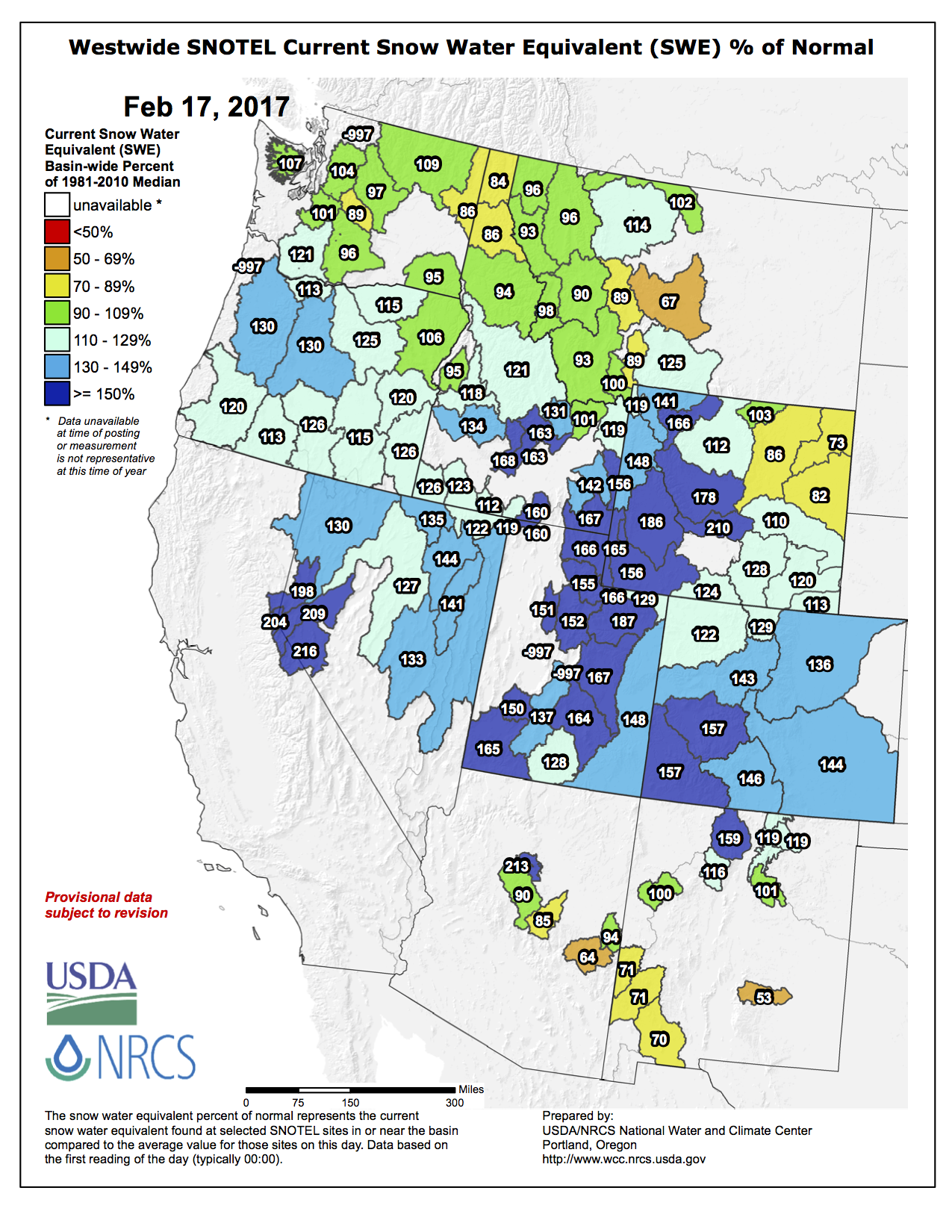
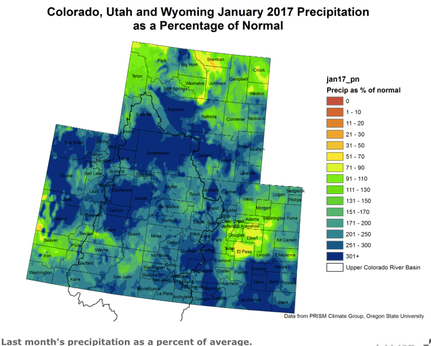
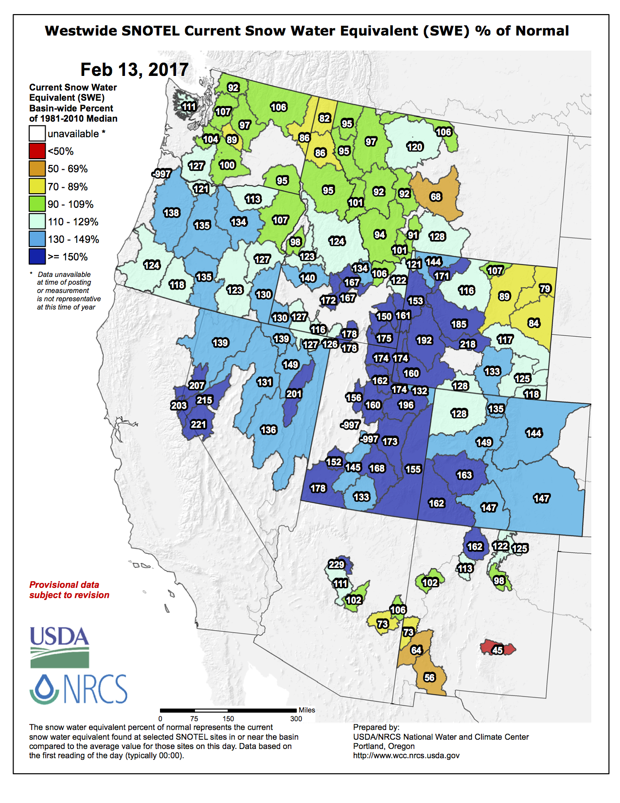
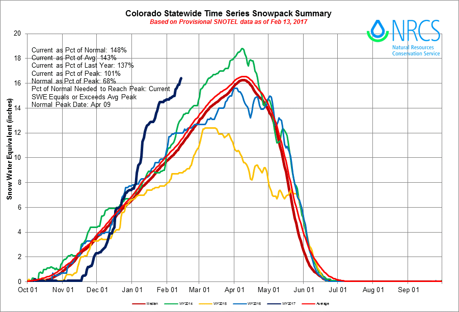
    Working in the state’s favor: We’re not in a drought and “we had a great wheat crop this summer,” Brown said. [ed. The Eastern Plains are in drought.]

    But it goes downhill from there.

    Prices for beef, corn and wheat have plummeted. These commodities are at 1986-price levels, but with 2017 production costs, Brown said.

    Low prices mean it costs farmers more to produce those crops than can be made from selling them. Some of the crops also had record yields in 2016, but that’s not as good as it might sound. Lower demand for corn-based ethanol, partly because vehicles are more fuel-efficient, means the corn supply outstrips the demand.

    It’s causing some farmers to look for other revenue sources, such as selling or leasing their water rights until market prices recover. In LaSalle, Colorado, for example, Chuck and Ronibell Sylvester sold water rights to 110 acres on their farm to the city of Aurora in December, keeping just a few acres for grazing.

    The outlook for livestock, especially Colorado’s cattle industry, isn’t any better. The report said cattle prices reached a high watermark in 2014 at around $148 per hundred pounds, but prices have dropped 21 percent since then to about $123 per hundred pounds. A steer sells at around 400 to 500 pounds.

    Add to falling prices a stronger U.S. dollar against foreign currencies, which is driving up the cost of Colorado agricultural exports in overseas markets, Brown said.

    @CUBoulder: Newly engineered material can cool roofs, structures with zero energy consumption

    coolingmaterialcuboulder0220167

    Here’s the release from the University of Colorado at Boulder:

    A team of University of Colorado Boulder engineers has developed a scalable manufactured metamaterial — an engineered material with extraordinary properties not found in nature — to act as a kind of air conditioning system for structures. It has the ability to cool objects even under direct sunlight with zero energy and water consumption.

    When applied to a surface, the metamaterial film cools the object underneath by efficiently reflecting incoming solar energy back into space while simultaneously allowing the surface to shed its own heat in the form of infrared thermal radiation.

    The new material, which is described today in the journal Science, could provide an eco-friendly means of supplementary cooling for thermoelectric power plants, which currently require large amounts of water and electricity to maintain the operating temperatures of their machinery.

    The researchers’ glass-polymer hybrid material measures just 50 micrometers thick — slightly thicker than the aluminum foil found in a kitchen — and can be manufactured economically on rolls, making it a potentially viable large-scale technology for both residential and commercial applications.

    “We feel that this low-cost manufacturing process will be transformative for real-world applications of this radiative cooling technology,” said Xiaobo Yin, co-director of the research and an assistant professor who holds dual appointments in CU Boulder’s Department of Mechanical Engineering and the Materials Science and Engineering Program. Yin received DARPA’s Young Faculty Award in 2015.

    The material takes advantage of passive radiative cooling, the process by which objects naturally shed heat in the form of infrared radiation, without consuming energy. Thermal radiation provides some natural nighttime cooling and is used for residential cooling in some areas, but daytime cooling has historically been more of a challenge. For a structure exposed to sunlight, even a small amount of directly-absorbed solar energy is enough to negate passive radiation.

    The challenge for the CU Boulder researchers, then, was to create a material that could provide a one-two punch: reflect any incoming solar rays back into the atmosphere while still providing a means of escape for infrared radiation. To solve this, the researchers embedded visibly-scattering but infrared-radiant glass microspheres into a polymer film. They then added a thin silver coating underneath in order to achieve maximum spectral reflectance.

    “Both the glass-polymer metamaterial formation and the silver coating are manufactured at scale on roll-to-roll processes,” added Ronggui Yang, also a professor of mechanical engineering and a Fellow of the American Society of Mechanical Engineers.

    “Just 10 to 20 square meters of this material on the rooftop could nicely cool down a single-family house in summer,” said Gang Tan, an associate professor in the University of Wyoming’s Department of Civil and Architectural Engineering and a co-author of the paper.

    In addition to being useful for cooling of buildings and power plants, the material could also help improve the efficiency and lifetime of solar panels. In direct sunlight, panels can overheat to temperatures that hamper their ability to convert solar rays into electricity.

    “Just by applying this material to the surface of a solar panel, we can cool the panel and recover an additional one to two percent of solar efficiency,” said Yin. “That makes a big difference at scale.”

    The engineers have applied for a patent for the technology and are working with CU Boulder’s Technology Transfer Office to explore potential commercial applications. They plan to create a 200-square-meter “cooling farm” prototype in Boulder in 2017.

    The invention is the result of a $3 million grant awarded in 2015 to Yang, Yin and Tang by the Energy Department’s Advanced Research Projects Agency-Energy (ARPA-E).

    “The key advantage of this technology is that it works 24/7 with no electricity or water usage,” said Yang “We’re excited about the opportunity to explore potential uses in the power industry, aerospace, agriculture and more.”

    Co-authors of the new research include Yao Zhai, Yaoguang Ma and Dongliang Zhao of CU Boulder’s Department of Mechanical Engineering; Sabrina David of CU’s Materials Science and Engineering Program; and Runnan Lou of the Ann and H.J. Smead Department of Aerospace Engineering Sciences.

    What she really wants for Valentine’s Day – News on TAP

    Forget diamonds and chocolate. We have something better in mind.

    Source: What she really wants for Valentine’s Day – News on TAP

    SNOWPACK IN THE ROCKIES: Hey, it’s not ALL about California!

    #ColoradoRiver #COriver

    #ClimateChange: I’m just one person, what can I do? @KHayhoe

    “We can make the biggest changes when we work together” — Katharine Hayhoe