The board discussed the issue at its Thursday board meeting and will revisit contributing to the $300,000 program at its March 2 meeting.
The inspections are to prevent invasive mussels from getting into the water via boats. If these mussels get into the water, which is used for drinking and agriculture through the region, they can affect aquatic life as well as the infrastructure that stores and moves the water.
Previously, Colorado Parks and Wildlife paid for all the inspections statewide at a cost of $4.5 million, but the agency lost its funding this summer due to a Colorado Supreme Court decision that changed the face of oil and gas severance taxes.
The parks agency is working on legislation for new fees to cover the program as soon as 2018, but the funding for this summer is up in the air.
Stakeholders proposed a three-way split of the total $300,000 cost at the two reservoirs. Larimer County agreed to pay one third from its parks fees, Colorado Parks and Wildlife agreed to pay one third from its reduced budget, and officials with both agencies had hoped Northern Water would kick in the final piece.
After its meeting Thursday, the board released the following statement: “The Northern Water board was briefed … regarding the funding challenges for ongoing boat inspections on the reservoirs associated with the Colorado-Big Thompson Project. Following significant discussion, the board directed staff to continue discussions with the various aquatic nuisance species (ANS) stakeholders. It is likely staff will provide a related resolution and a 2017 ANS funding plan to the board at its March planning and action session.”
Map of the Colorado-Big Thompson Project via Northern Water
About 94,000 acres of the land targeted for disposal is in Colorado. Seven parcels totaling 560 acres are located in Larimer County.
The future of public lands has been in the spotlight post-election, especially after President [#45] picked Montana Congressman Ryan Zinke for the U.S. Secretary of Interior post. Some conservationists said Zinke’s voting record on public lands conflicted with his verbal opposition to selling them off.
Conservationists say public land preservation is crucial to Western lifestyle, recreation and environment. Others argue the government maintains too much land that could be more valuable if developed or handled by local authorities.
At his confirmation hearing, Zinke vowed to protect America’s public lands — and then headlines started cropping up about Utah Rep. Jason Chaffetz’s bill.
Chaffetz has introduced similar bills in previous sessions, but some thought this year’s iteration stood a better chance in the Republican-controlled U.S. House and Senate. The crux of the bill was a 1996 federal report that identified 3.3 million acres of public land for potential transfer to states…
Strong backlash prompted Chaffetz to kill the bill last week, a decision he announced through an Instagram post.
“I am withdrawing HR 621,” read the post. “I’m a proud gun owner, hunter and love our public lands. The bill would have disposed of small parcels of lands Pres. Clinton identified as serving no public purpose but groups I support and care about fear it sends the wrong message. The bill was originally introduced several years ago. I look forward to working with you. I hear you and HR 621 dies tomorrow.”
Killing the bill was a good call, said Jeremy Nichols, climate and energy program director at WildEarth Guardians, an environmental group. He added the 1996 report was a “complete hypothetical idea” produced back when the U.S. government was weighing funding options for restoration of the Florida Everglades.
“It speaks to just how haphazard and ill-conceived this idea was,” Nichols said. “Putting this hypothetical into legislation to mandate the sale of these lands — it was just stupid.”
Artesian well Dutton Ranch, Alamosa 1909 via the Crestone Eagle
From the Colorado Cattleman’s Association via FencePost:
The next Colorado Ag Water Alliance Ag Producers’ Water Workshop will be held Feb. 28 at the Rio Grande Water Conservancy District in Alamosa from 10 a.m. to 2 p.m. The event is free, and the organizers hope to have a good turnout of producers in the Rio Grande Basin region.
» The Colorado Water Plan aims to address the water needs of cities, agriculture and the environment in light of projected shortages. Agriculture is a focus.
» What are alternative transfer methods? What’s the motivation for farmers and ranchers to participate in leasing or to improve irrigation efficiency? What are the barriers?
» Brief, highly focused presentations and panel dialogue will cover the basics, followed by opportunity for ag producers to ask questions and engage in dialogue about what they see as opportunities and barriers — and how those barriers and opportunities might best be addressed.
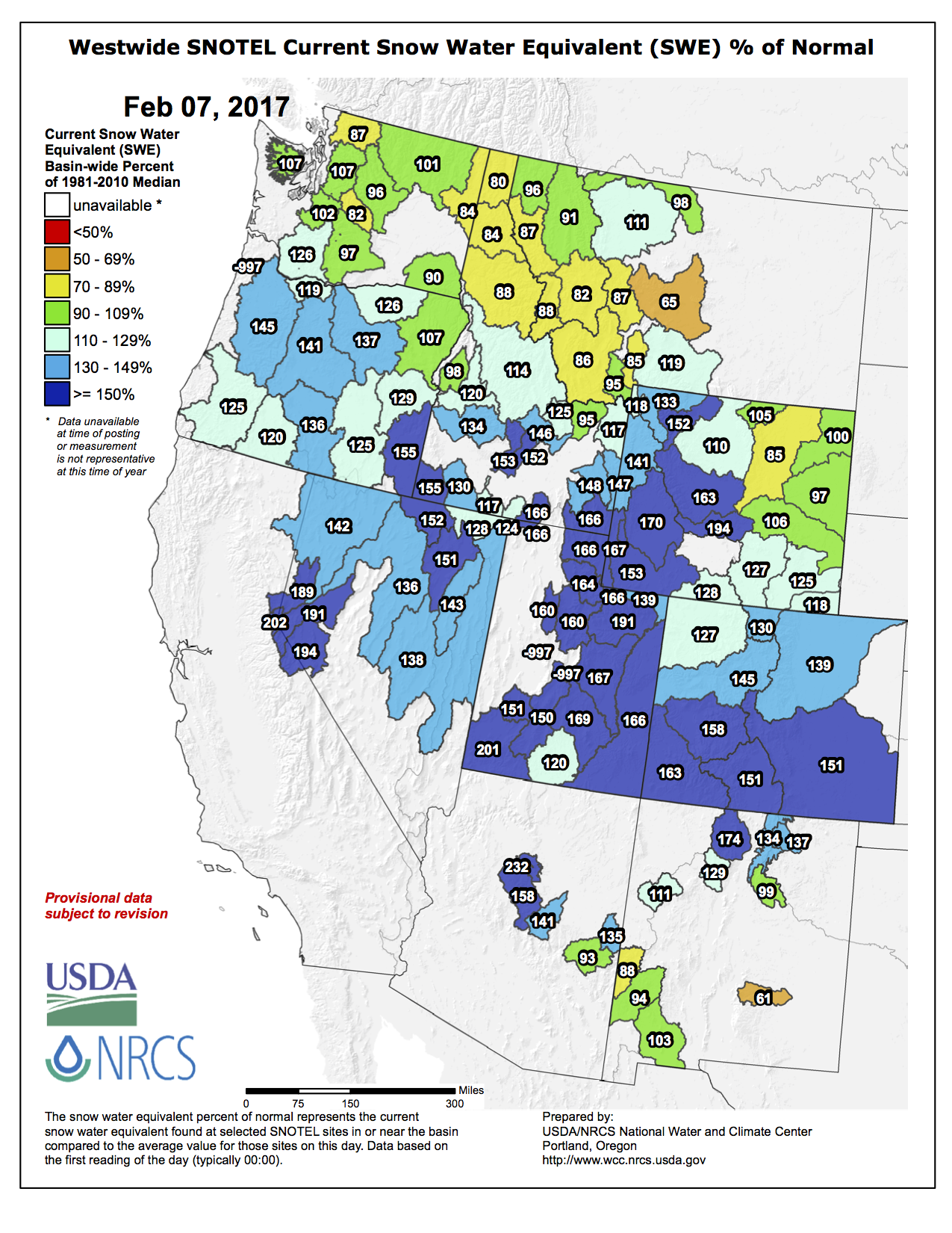
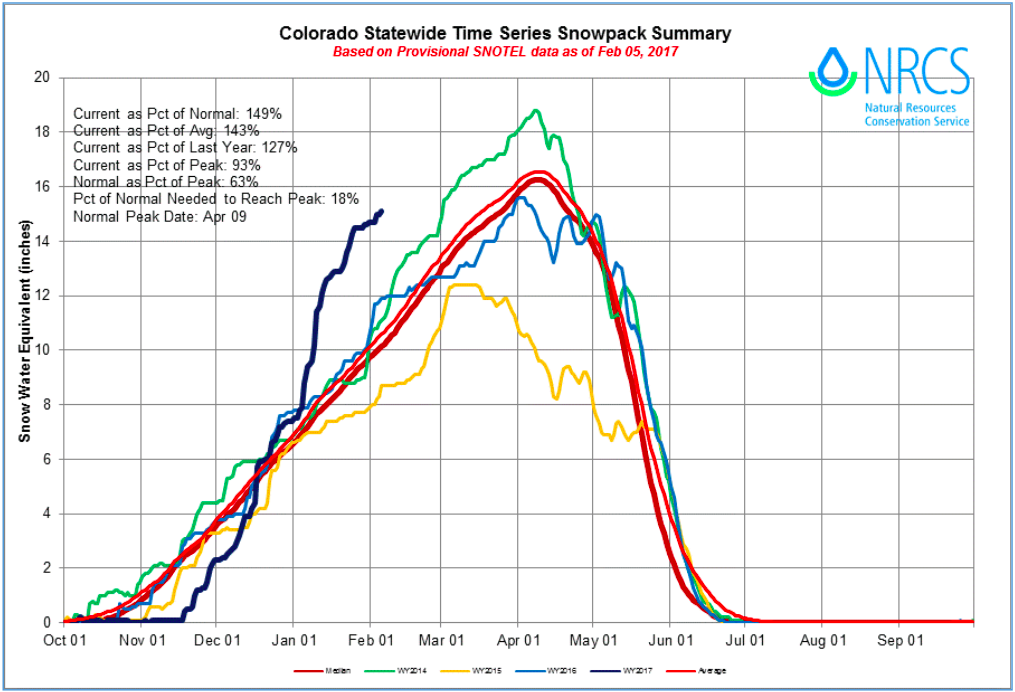
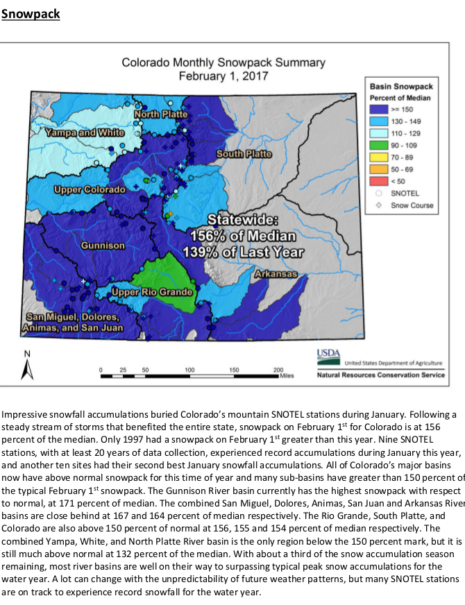
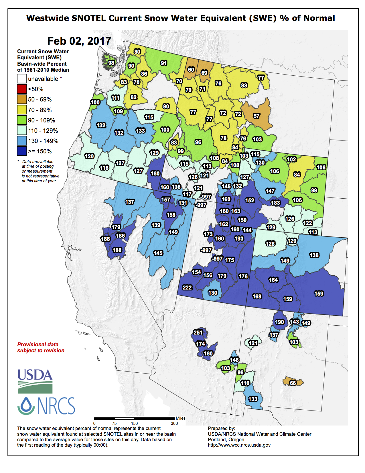
Snowfall in January on the state’s mountains more than doubled its normal amount. This helped boost the state’s snowpack into healthy territory. Mountain snowfall melts in the warmer months and provides much of Weld County’s water.
“It’s definitely been a very interesting pattern this season,” said Karl Wuetlaufer, assistant snow survey supervisor for the Natural Resources Conservation Service. “We did have a notably late start to the snow accumulation season.”
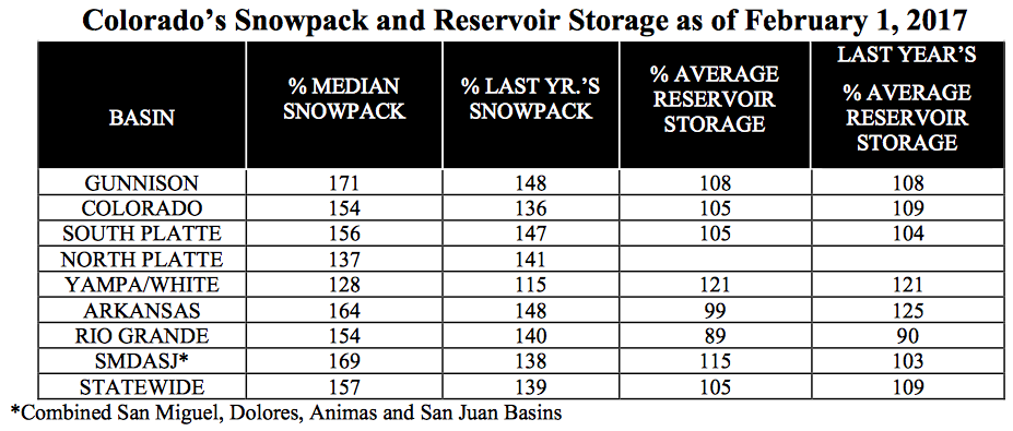
The significant snowfall in January boosted the state’s snowpack to 157 percent of average on Feb. 1 from 114 percent of average on Jan. 1, according to data released this month by the Natural Resource Conservation Service. In the river basins that affect Weld, the Colorado and South Platte, snowpack also jumped. In the Colorado basin it hit 154 percent of average on Feb. 1, up from 117 on Jan. 1. In the South Platte basin, snowpack hit 156 percent of average on Feb. 1, up from 105 percent of average…
“We’re definitely positioned very well for having ample water supply this year,” he said, noting that statewide as of Feb. 1 the snowpack had already hit 93 percent of its normal peak value for the entire season. That mark is usually hit in the first weeks of April. “We have already achieved near a normal peak value. That’s what you could think of as in the bank.”
Additionally, reservoir storage looks strong, the South Platte and Colorado river basins were at 105 percent of average reservoir storage on Feb. 1.
He said the state would only need to see 19 percent of its normal mountain snowfall over the next couple of months to achieve a normal snowpack.
“We’ll likely have ample water supply. The flipside is if we do continue to build more and more snowpack and it gets bigger, then it becomes more of a concern of flooding,” he said. “There’s a lot of winter left and a lot can happen, but we do have a pretty substantial snowpack for this time of year.”
Gore Creek is healthy as it emerges from the Eagles Nest Wilderness Area, but has problems soon after, via The Mountain Town News. All photos by Jack Affleck.
This revegetation project uses log cribbing to hold the bank of Gore Creek in place while the plants get established. The logs will slowly decay. Photo credit Jack Affleck via The Mountain Town News.
Riparian areas were crowded or completely eliminated as the town was developed. In this, Vail is hardly alone. Photo by Jack Affleck via The Mountain Town News.
Streets and other artificial impervious areas result in rapid runoff of pollutants into the creek. Photo via The Mountain Town News and Jack Affleck.
A host of problems threaten Gore Creek in Vail, but one of the biggest is what runs through the town’s storm drains.
Some of the problem will take years and a lot of money to solve. For instance, much of the runoff in town is no longer filtered through the soil, which has been replaced by pavement, concrete and rooftops throughout the years. But a number of problems may be due to people simply not knowing what happens when something runs into a storm grate.
Vail Watershed Education Coordinator Pete Wadden recently updated the Vail Town Council about state of stormwater and its treatment in town.
IMPROVED FILTRATION
There are a number of ways to treat stormwater, including catch basins that can capture sand, oil and other material before it flows into the creek. There are 27 of those basins in town at the moment, and they’re cleaned out a couple of times every year, Wadden said. Upgrading those basins would be effective, but expensive, Wadden said.
Filtration has been improved at the town’s snow storage site, and improvements are planned for this year at the East Vail Interstate 70 interchange.
But the basins don’t catch everything.
There are also more than 2,000 storm drains, many of which flow directly into the creek. Slowing the runoff is a good start at cleaning up those areas. Creating zones where runoff could filter through rocks and soil before going into the creek could be effective.
Then there’s the problem of people dumping stuff into the storm grates.
During his presentation, Wadden went through a small list of stuff that people dropped into storm grates in 2016. That list includes cooking grease, paint and window cleaner.
A member of a construction crew in Vail Village dumped a bag of cement into a storm drain.
Town crews had to vacuum out the storm grate to catch as much of the powdered cement as possible. Wadden said the construction company wouldn’t name the employee who dumped the cement, so no ticket was issued.
In a separate incidence, no ticket was issued to a vendor at the 2016 GoPro Mountain Games who dumped 120 hot dogs down a storm drain, which resulted in another good-sized cleanup.
“People just don’t know where the water goes,” Wadden said.
Council members said that needs to change.
An education campaign is already under way that includes advertising on town buses, and a proposal to create awareness-raising art on town storm drains. There’s also a town hotline, 970-476-4673 (GORE), to report dumping into storm drains. But that phone is only answered during normal business hours.
Council member Dick Cleveland asked if the phone could be routed into the town’s emergency dispatch center.
‘EASY TO UNDERSTAND’
Cleveland also asked Wadden if the education campaign could be expanded to include some sort of notice at virtually every storm grate in town. Cleveland said that’s the case in a California town near the beach.
Special Master Gregory Grimsal declined New Mexico’s request to toss out Texas’ lawsuit — essentially reaffirming draft rulings he issued in mid-2016 that was seen as a blow to New Mexico’s case.
The rulings are not the end of the case. They must now be reviewed by the Supreme Court, attorneys involved in the case said. And the entire matter could end up in a trial if not settled.
After the draft rulings, Grimsal took feedback from the parties involved and could have modified his stances in the document released Thursday. Instead, the final conclusions were the same as in the draft.
An attorney for Las Cruces-based Elephant Butte Irrigation District, which has been at odds with the state of New Mexico over the lawsuit, said the rulings represent a “victory” for the irrigation district. He said they recognize that “EBID members’ surface water rights are senior to all water rights in the basin” and that “the state engineer is obligated to protect that water as EBID delivers that water.”
[…]
The lawsuit arose out of the nature of the 1938 Rio Grande Compact, which apportioned river water among three U.S. states, experts have said. New Mexico’s measuring point for delivering water to Texas was the Elephant Butte Reservoir — roughly 100 miles north of the Texas state line. The river water released from the reservoir serves farmers in New Mexico-based EBID and Texas-based El Paso County Water Improvement District No. 1, as well as in Mexico. The groundwater pumping in that same 100-mile stretch, however, has been the purview of the New Mexico State Engineer’s Office.
Texas has argued New Mexico has over-pumped groundwater, undermining El Paso irrigators’ share of river water. EBID attorneys have said Grimsal’s rulings indicated New Mexico not only was obligated to deliver river water to Elephant Butte Reservoir for downstream users, but also had to protect it from being undermined before reaching the Texas state line.
Hernandez said the special master’s decision from Thursday must now be reviewed by the U.S. Supreme Court, which could take a few different approaches. The court could accept it outright or allow the states involved to make written — or possibly oral — arguments regarding Grimsal’s decision.
If the court affirms the ruling and sends the case back to Grimsal, the case would then be scheduled for a trial, which Grimsal would oversee. The outcome of the trial also would have to be reviewed and signed off upon by the Supreme Court, Hernandez said.
New Mexico Attorney General Hector Balderas announced last week he had met with stakeholders and is hoping to negotiate with Texas toward a resolution of the case.
In addition to declining New Mexico’s motion to dismiss the case, Grimsal on Thursday declined motions by EBID and EPCID No. 1 to become official parties in the case, alongside New Mexico, Texas and Colorado. Also, he specified the federal government couldn’t file a claim against New Mexico based on the 1938 Rio Grande Compact but that the federal government could make an argument against New Mexico under federal reclamation law, according to the document.
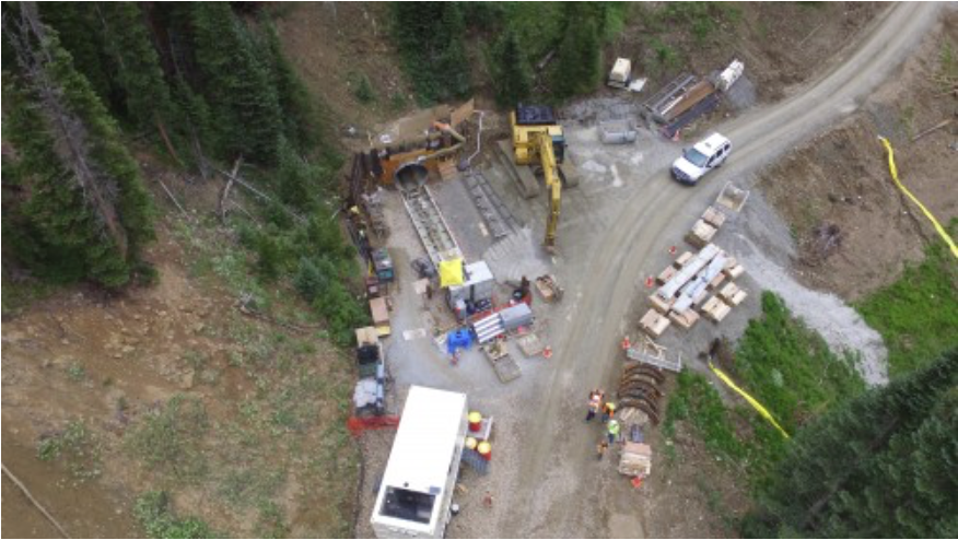
Directional drilling from one well site via the National Science Foundation
FromThe Grand Junction Daily Sentinel (Dennis Webb):
The company believes it can do without a pad that would be located adjacent to Battlement Mesa’s golf course.
Cutting the pad would reduce to four the total number of pads Ursa would drill from within the community of several thousand people. Antero Resources earlier had proposed drilling from 10 pads within the community. Ursa, which subsequently bought Antero’s local assets, has worked to cut the number of pads needed, in part through directional drilling from pads outside the residential development’s borders.
Ursa has Garfield County and state approvals to drill from two pads so far in Battlement Mesa and plans to begin drilling this year. It also has begun the process of seeking approvals for additional pads.
Don Simpson, vice president of business development for Ursa, said Ursa will eliminate the pad by the golf course from its plans if it can get approvals for two additional pads it is proposing, and for a wastewater injection well for one of them.
This week, it dropped efforts to obtain approvals for the injection well close to the community’s water intake on the Colorado River. The proximity and the potential for impacts from spills drew objections from the Colorado Department of Public Health and Environment and county planning staff.
Simpson said the pad now proposed is downstream from the water intake and 2,000 feet from the river. He said changing the location probably will mean extra truck traffic for a while because Ursa doesn’t have approval yet and may not be able to begin injecting wastewater until next year. Trucks would have to haul wastewater out of Battlement Mesa in the meantime. Reducing truck traffic is a key reason Ursa wants to have an injection well.
If the injection well is approved, that would be one less reason for Ursa to need the pad near the golf course.
Simpson said the two additional pads Ursa is pursuing are now planned to be larger, which will allow for more wellheads.
“We think this is a big win for everybody except for the people that don’t want you in (Battlement Mesa) regardless of what you do,” he said.
Dave Devanney of the group Battlement Concerned Citizens, said he’s a bit conflicted on how to react to the latest Ursa developments.
“As somebody said recently, name your poison. Do you want truck traffic or do you want injection wells? The citizens of Battlement Mesa don’t want either,” he said.
Meanwhile, Ursa Resources held a meeting with Battlement Mesa residents yesterday. Here’s a report from Alex Zorn writing for The Glenwood Springs Post-Independent. Here’s an excerpt:
The meeting, one of Ursa’s regular sessions with residents, came a day after a zoning change proposed on Ursa’s behalf was withdrawn.
Thursday’s meeting lasted nearly two hours, and Ursa representatives spent nearly the entire time fielding questions from concerned residents.
A conversation that began as an outline for development ended with residents demanding to know if Ursa will leave the community in better shape than they found it.
“Do you see any benefit for the Battlement Mesa citizens from oil and gas?” asked one audience member.
Ursa owns mineral rights under the 5,000-person community and last year won Garfield County and state approval to drill for natural gas inside the Planned Unit Development. Wednesday, a request to place an injection well to dispose of wastewater within the PUD was pulled back after county staff urged rejection.
The state Department of Public Health and Environment earlier urged rejection because the well would be within about 600 feet of the municipal water intake.
The Planning Commission granted a continuance so that Battlement Mesa Partners, which requested the zoning change for Ursa’s natural gas operations, can alter its plan. The hearing was moved to the March 8 Planning Commission meeting.
“The reason for last night’s continuance is to allow us to present all of the changes we’ve made, which will allow us to move the injection well from the BMC B Pad to the BMC A Pad,” Ursa Resources Operations Superintendent Matt Honeycutt said. “We wanted to get it right, and part of that was by talking with many of you.”
Moving the injection well from the B Pad to A Pad will eliminate the threat of any runoff leaking into the Colorado River and contaminating the water supply, he said.
Instead of placing the injection well upriver from the intake, which it would be in the B Pad, Ursa will seek to place the injection well downriver at the BMC A Pad.
Furthermore, he said, shifting focus to the A Pad will eliminate the impact to the area surrounding the B Pad, which will reduce the area of the project by nearly 50 percent. Rather than rezoning 37 acres along the north end of the community by the north end of the Colorado River, the new plan will include closer to 22 acres.
The plan will still be to drill 24 wells in the BMC B Pad, but having an injection well in the community will greatly reduce truck traffic, according to Honeycutt.
Construction will begin for the B Pad on Feb. 21, the company said, with as many as 14 wells to be located there.
Now, 100 wells are in operation out of approximately 200 wells that Ursa plans to drill in Battlement Mesa, though the company has not yet begun to drill within the PUD, representatives said.
Drilling for a pipeline has begun, with 15 of 24 wells already in operation. Drilling is expected to be completed by March 23. Once the drilling is completed there, Ursa will begin drilling at the D Pad.
One resident was frustrated, asking, “Of all of this land, how come you have to do this right here?”
Synopsis: ENSO-neutral conditions have returned and are favored to continue through at least the Northern Hemisphere spring 2017.
La Niña conditions are no longer present, with slightly below-average sea surface temperatures (SSTs) observed across the central equatorial Pacific and above-average SSTs increasing in the eastern Pacific. The latest weekly Niño index values were -0.3°C in the westernmost Niño-4 and Niño- 3.4 regions, and +1.5°C in the easternmost Niño-1+2 region. The upper-ocean heat content anomaly increased during January and was slightly positive when averaged across the eastern Pacific, a reflection of above-average temperatures at depth. Atmospheric convection remained suppressed over the central tropical Pacific and enhanced over Indonesia. The low-level easterly winds were slightly enhanced over the western tropical Pacific, and upper-level westerly winds were near average. Overall, the ocean and atmosphere system is consistent with ENSO-neutral conditions.
Most models predict the continuation of ENSO-neutral (3-month average Niño-3.4 index between -0.5°Cand0.5°C)through the Northern Hemisphere summer. However,a few dynamical model forecasts, including the NCEP CFSv2, anticipate an onset of El Niño as soon as the Northern Hemisphere spring (March-May 2017). Because of typically high uncertainty in forecasts made at this time of the year for the upcoming spring and summer, and the lingering La Niña-like tropical convection patterns, the forecaster consensus favors ENSO-neutral during the spring with a ~60% chance. Thereafter, there are increasing odds for El Niño toward the second half of 2017 (~50% chance in September-November). In summary, ENSO-neutral conditions have returned and are favored to continue through at least the Northern Hemisphere spring 2017 (click CPC/IRI consensus forecast for the chance of each outcome for each 3-month period).
From email from the Colorado Water Conservation Board (Ben Wade):
The next Water Availability Task Force meeting will be held on Wednesday, February 15, 2017 from 12:30-1:30pm at the Colorado Parks & Wildlife Headquarters, 6060 Broadway, Denver in the Red Fox Room. (Please note the earlier start time of 12:30p.
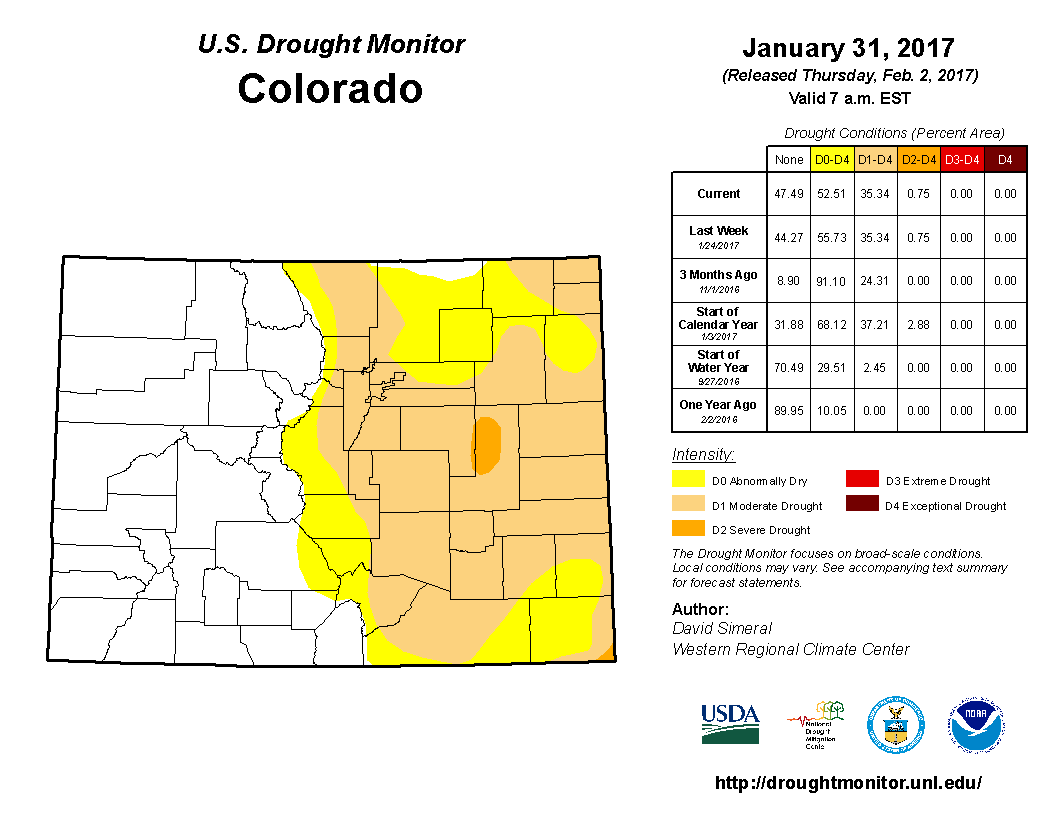
Click here to go to the US Drought Monitor Website. Here’s an excerpt:
Summary
This U.S. Drought Monitor week saw a very active pattern in parts of the western U.S. as a series of Pacific storms brought significant rain to coastal areas of central and northern California, Oregon, and Washington while heavy snows blanketed higher elevations of the Sierra, Cascades, and northern Rockies. Continued snowfall this week across the Sierra is making a positive impact on the overall drought situation where the snowpack statewide is 176% of normal according to the California Cooperative Snow Surveys. Most of the major reservoirs in California are currently above historical averages. Some lingering hydrologic impacts (low reservoir levels and below-normal groundwater levels) are still present in portions of the central Coast, southern California, San Joaquin Valley, and the western foothills of the Sierra despite abundant precipitation during the past several months. Elsewhere in the West, mountain snowpack levels are normal to above normal across the Great Basin, southern Cascades, Wasatch, as well as central and southern Rockies. In the southern Plains and portions of the South, overall dry conditions have persisted, especially across Arkansas and Oklahoma. During the past week, temperatures were above normal across most of the conterminous U.S. with the exception of the northern Plains and much of the Pacific Northwest where temperatures were 5 to 20 degrees below normal with the greatest departures observed across Montana…
The Plains
On this week’s map, only minor changes were made across the region in the Panhandle of Nebraska in an area of Abnormally Dry (D0) where precipitation during the past 30 to 90 days and increased soil moisture led to improvements. Overall, the region was dry during the past week. Average temperatures were well below normal (5 to 15 degrees) in northern portions while southern portions were above normal…
The West
During the past week, a series of storms bringing widespread rain and snow showers impacted the states along the Pacific Coast and northern Rockies. In California, the cumulative effect of several months of abundant precipitation has significantly improved drought conditions across the state. Nearly all of California’s major reservoirs are currently above historical average levels with the state’s two largest reservoirs, Oroville and Shasta, currently at 126% and 124%, respectively. To date, the statewide percent of normal snow water equivalent sits at an impressive 176%, according to the California Cooperative Snow Surveys. Heavy snowfall this week in the Sierra led to improvements on the map in areas of Abnormally Dry (D0), Moderate Drought (D1), and Severe Drought (D2). Along the central Coast, continued heavy rains in the Santa Lucia Range led to improvements in areas of Abnormally Dry (D0), Moderate Drought (D1), and Severe Drought (D2) where streamflows and soil moisture levels are above normal. Along the southern California coast, one-category improvements were made in areas of Severe Drought (D2) where a wide variety of drought indicators (Palmer Drought Severity Index, Standardized Precipitation Index, streamflow activity, soil moisture levels, drought impact reports) at various timescales (30 days to 2 years) led to improvements in an area extending from southern Ventura County to San Diego County. In Santa Barbara and northern Ventura counties, an area of Extreme Drought (D3) has remained in place as local reservoirs and groundwater levels have been lagging behind other indicators as a result of the cumulative effect of significant long-term precipitation deficits. The Municipal Water District of Orange County (as of February 6, 2017) declared an end to the drought emergency. Elsewhere in the region, improvements were made in areas of Abnormally Dry (D0) and Moderate Drought (D1) in western Nevada. In Utah, areas of Abnormally Dry (D0) were reduced in western and northern portions in response to improvements in soil moisture and above-normal precipitation amounts during the past four-month period. The remaining area of Abnormally Dry (D0) in Utah covers areas in which below-normal reservoir levels persist…
Looking Ahead
The NWS WPC 7-Day Quantitative Precipitation Forecast (QPF) calls for moderate-to-heavy precipitation accumulations in northern California as well as western Oregon, western Washington, northern Idaho, and northwestern Wyoming. Moving eastward, lesser precipitation accumulations (less than 1.5 inches) are forecast for Texas, northern portions of the Mid-Atlantic, and eastern portions of the Midwest. Some heavier precipitation amounts (2 to 3 inches) are forecast for New England for the seven-day period. The CPC 6–10 day outlooks call for a high probability of above-normal temperatures across the entire conterminous U.S., with the exception of New England where below-normal temperatures are forecast to prevail. Below-normal precipitation is forecast for the Intermountain West, central and northern Plains, and the Midwest while above-normal precipitation is expected along the West Coast, South, and New England.
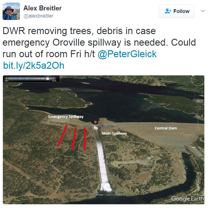
Officials from all three and the Bureau of Reclamation have been “scrambling” to find the money for the inspections so the boat ramps can open, as usual, at the beginning of April, noted Ken Brink, visitor services specialist for the Larimer County Department of Natural Resources.
“It’s less than two months away, so there’s a little pressure on us to get it squared away,” Brink said at a recent Parks Advisory Board meeting.
This funding arrangement is a bridge to cover 2017 while the state looks for permanent funding through new boat and fishing fees…
“This is our drinking water supply,” County Commissioner Tom Donnelly said Wednesday at a work session to talk about boat inspections. “You are concerned about recreational users. We have a bigger concern. This is our drinking supply for much of Northern Colorado and agricultural water.”
[…]
Larimer County manages recreation at the reservoirs, which are owned by the Bureau of Reclamation and hold Colorado-Big Thompson water that is managed by Northern Water.
Because of that stake in Carter and Horsetooth, Northern Water should help pay for the inspections this year, said Lew Gaiter, county commissioner.
“Ask your board to ante up,” he said to Brad Wind, deputy manager of the water district’s operations division. “You guys probably have more skin in the game than anyone else.”
Wind said he believes the board of directors for the water district will agree to pay $100,000 because the request is for a single year only until Colorado Parks and Wildlife can find a different funding source.
“We’re going to give our board the view that it’s very critical that we do something,” Wind said at the county commissioners’ work session.
“We’re optimistic we can convince them, at least for 2017.”
By 2018, Colorado Parks and Wildlife hopes the Legislature will have passed a new law creating an Aquatic Nuisance Species stamp that will be required on all boats at a cost of $15 to $50, depending upon the size of boat, where it is from and the risk for contamination. The law also would add a $1 fee to fishing licenses.
Both of these measures would bring in about $4 million per year, which would cover the cost of inspections throughout the state, Reid DeWalt, assistant director for wildlife and natural resources with Colorado Parks and Wildlife, explained at the county commissioners’ meeting Wednesday.
Colorado Parks and Wildlife has spent about $4.5 million per year since 2009 to pay for inspections at many of the lakes and reservoirs around Colorado, with all of the funding coming from oil and gas severance taxes.
However, a recent Colorado Supreme Court ruling that changed the tax rules and exemptions resulted in that source of funding drying up.
For this summer, the state agency found $2.8 million within its reserves and budget, which it will use to cover the highest-risk waters, and it will partner with local governments for inspections on their waters.
The hope is for a three-way partnership in Larimer County. The last needed approval is from Northern Water, which meets Thursday.
Parachute/Battlement Mesa area via the Town of Parachute.
FromThe Grand Junction Daily Sentinel (Dennis Webb):
Ursa Resources and the developer of Battlement Mesa have dropped a zoning change proposal necessary for Ursa to pursue…operating a wastewater injection well near the community’s water intake on the Colorado River.
Battlement Mesa Co. is cutting by about half the size of a proposed zone district that would allow injection wells as a special use. The move eliminates the northern portion of what had been a 37-acre proposed district. That northern portion included a well-pad location where Ursa has approvals to drill for natural gas and had hoped to operate the injection well.
The revised zone district proposal still would encompass another location to the southwest where Ursa has begun the process of seeking approvals for an oil and gas pad that also could hold an injection well if local and state approvals are obtained.
The Garfield County Planning Commission was to have considered the original zone district proposal Wednesday night, but instead agreed to consider the revised application March 8.
Ursa had encountered considerable opposition to its original planned location for the injection well, which would have been about 600 feet from the water intake.
The Colorado Department of Public Health and Environment had objected to that location because of concerns that leaks from the well and associated storage tanks could threaten the water supply. That agency’s opposition was a primary factor in Garfield County planning staff also recommending that the Planning Commission and county commissioners reject the zoning change.
On Tuesday, Kent Kuster, an environmental specialist for CDPHE, wrote to the county that in a recent meeting with Ursa representatives his agency was made aware of an alternative injection well location to the west of Ursa’s originally envisioned site. Kuster wrote that the potential location would “reduce the associated risk to the public water supply,” is more protective of that supply and may warrant further local discussion.
Battlement Mesa is an unincorporated community of several thousand people. Dave Devanney of Battlement Concerned Citizens said the group’s members don’t want an injection well anywhere within Battlement Mesa. But the group had been particularly alarmed by the idea of an injection well in the vicinity of the water intake.
In a news release Wednesday, Devanney called the change in Ursa’s plans a victory for residents.
“It was clear that public opinion was against the idea of creating an injection well zone in our community, especially one so close to our drinking water supply,” Devanney said. “Although we may see this proposal resurface in another form, tonight residents of Battlement Mesa can take comfort knowing their water is safe — for now.”
[…]
Matt Honeycutt, Ursa’s operations superintendent, declined to say much Wednesday night about the revision in the injection well plans.
“Ultimately it’s to make a better project,” he said.
Don Simpson, Ursa’s vice president of business development, said earlier Wednesday, “We think we’ve come up with a better plan. We’re always looking at different locations, better locations.”
Eric Schmela, president of Battlement Mesa Co., which as the landowner is the applicant for the zoning change, said a number of considerations played into its decision to revise its proposal, from public input, to its own research and additional due diligence.
One member of the Planning Commission, Greg McKennis, sought unsuccessfully Wednesday night to postpone further consideration of the zoning application for 60 to 90 days to give Battlement Mesa residents a chance to fully learn what’s now being proposed and be able to better comment on it.
“This is a big change and we have no idea what those impacts will be,” he said. “… It’s vital that that community … has more than a couple weeks to do what they need to do to review this,” he said.
However, the applicants had a right to request another hearing sooner unless they waived it, which they weren’t willing to do.
“This timing becomes critical down the road to remove trucks off the road for our development plan,” Honeycutt told the commission.
Ursa says having an injection well will eliminate the need to truck away wastewater from drilling. It currently has approvals to drill more than 50 wells from two pads in Battlement Mesa and now is seeking approvals for three more well pads there.
Battlement Mesa Partners, requesting the zoning change for Ursa Resources’ natural gas operations, asked commissioners before a packed hearing room for time to amend the proposal…
The hearing was moved to the March 8 Planning Commission meeting. The Planning Commission staff last week recommended rejecting the proposal in large part because it is close to the community’s water intake.
“I think it would be in the board’s best interest to allow for a continuance so that we can make changes to our application,” said Eric Schmela, president of Battlement Mesa Co. “A continuance would allow us to bring you more complete information on the request.”
Among the biggest changes would be to change the size of the area requested for rezoning to allow wells to dispose of wastewater from the fracking process. Drilling within the Planned Unit Development already has been approved by Garfield County and the state.
According to Schmela, the revised application will reduce the area of the project by nearly half. The previous proposal sought to rezone 37 acres along the north end of the community by the Colorado River. An updated application will reduce that area by 50 percent, stated Schmela.
Not only will the new application reduce the size of the injection zone, but it will also move the well away from the Colorado River and water treatment intake.
The Durango City Council unanimously voted to place the question on the ballot following more than a year of heated meetings and debate. The council’s other option was to adopt an ordinance prohibiting fluoride, and none of the councilors seemed to support it.
The question will ask voters whether they wish to prohibit the addition of fluoride or any chemical containing fluoride to city water…
The city has released a series of documents on its website on the fluoride it adds to the water, City Manager Ron LeBlanc said.
The city does not add pharmaceutical-grade fluoride to the water, he said…
Residents can also review the results of tests done on the water before it’s treated and afterward, he said. The documents can be found at http://bit.ly/2loX6oj or by searching the “fluoride” on the city’s website.
Pueblo County – having already received a commitment of $460 million in stormwater projects from Colorado Springs over 20 years – now wants to join in a federal and state lawsuit citing Colorado Springs for violating its federal stormwater permit…
Wednesday, Pueblo County commissioners decided to try to join in the lawsuit, following a December effort by the Lower Arkansas Valley Water Conservancy District to also become a plaintiff. The motion to include the Lower Ark, as it is known, hasn’t been decided.
The Lower Ark, representing Bent, Crowley, Otero, Prowers and Pueblo counties, has seen Colorado Springs break stormwater promises repeatedly, said district Executive Director Jay Winner.
Pueblo County commissioners echoed such complaints, saying the city doesn’t adequately fund its stormwater management program, maintain the infrastructure or reduce discharge of pollutants.
In addition to the $460 million stormwater pact, the city has increased stormwater funding to $19 million a year, including $3 million from Colorado Springs Utilities. That’s up from $5 million in 2015.
Pueblo County and Lower Ark both cite increased E. coli levels, erosion, sedimentation and flooding.
The county’s action was another blow for Mayor John Suthers, who has committed to rectifying the city’s stormwater problems since he took office in June 2015…
Said Pueblo County Commission spokeswoman Paris Carmichael: “This isn’t about picking a fight with Colorado Springs. This is about giving the citizens of Pueblo County a voice.”
The county had threatened last year to withhold a permit essential for completion of the $825 million Southern Delivery System, a massive water project delivering Arkansas River water to Colorado Springs, Security, Fountain and Pueblo West.
So Suthers and other city officials worked with Pueblo city and county officials to hammer out the $460 million intergovernmental agreement, which facilitated release of the permit.
Meanwhile, Suthers also got to work reorganizing the city’s Stormwater Division, bringing in new director Richard Mulledy, who had worked in Pueblo; ratcheting up its staff from 28 to an eventual 66; and releasing an inch-thick new Stormwater Program Implementation Plan on Nov. 2, one week before the EPA filed suit.
The mayor now is asking voters to approve an April 4 ballot measure that would let the city retain $6 million in excess sales tax revenues to further improve the stormwater system. The city’s extra tax money is expected to top out at $9 million or more, with any amount above the $6 million request being refunded to residents if the ballot issue passes.
The Pueblo County commissioners on Wednesday asked staff to file a motion to intervene in a lawsuit filed Nov. 9 in U.S. District Court in Denver by the Environmental Protection Agency and the Colorado Department of Public Health and Environment against Colorado Springs.
Pueblo County wants to join the case to protect its interest during the litigation.
“We did it primarily to make sure we have a seat at the table,” said Pueblo County Commission Chairman Terry Hart.
“It’s one of those issues that whenever any kind of conversation is going on that concerns Fountain Creek or the water volume or quality that’s in the creek, we feel it affects the citizens in our community.”
[…]
Hart and fellow Commissioners Sal Pace and Garrison Ortiz said although there are pros and cons in entering the lawsuit, representing Pueblo County citizens is the most important issue.
“I feel that we have an obligation as a board, as elected officials and as leaders in Pueblo County to ensure that we are doing absolutely everything we can to protect our infrastructure, quality of water and the health and welfare of our citizens,” Ortiz said.
Pace said he greatly cherishes the relationship the county has developed with Colorado Springs through negotiations over the Southern Delivery System’s 1041 permit agreement and hopes this will not do anything to damage it…
Suthers’ office issued a statement from the mayor when contacted Wednesday.
“In light of the fact that Pueblo County is well aware of the outstanding stormwater program Colorado Springs is putting together and that we are meeting and exceeding our commitments under the intergovernmental agreement between our entities, I am very disappointed in their decision to seek to intervene in the EPA lawsuit. Intervention by parties without regulatory authority will only serve to make the litigation more complex, more lengthy, more expensive for all parties and possibly more unproductive.”
[…]
The Lower Arkansas Valley Water Conservancy District also wants to join the case as an intervenor to protect the district’s interest during the litigation.
The district filed the same motion in November. A federal judge has yet to make a decision on if the district can join the suit…
Pueblo City Council President Steve Nawrocki said the city manager will ask Council on Monday to give him direction on the issue…
WHAT IT MEANS
By intervening in the lawsuit Pueblo County hopes to:
Support the EPA and CDPHE in its regulatory mission.
Ensure that stormwater control infrastructure within Colorado Springs is properly operated and maintained.
Ensure that there are no conflicts or inconsistencies between the stormwater intergovernmental agreement recently entered by the county and Colorado Springs and any remedy, judgment or settlement entered in this case.
Require Colorado Springs to become, and then remain, compliant with the Clean Water Act, the Colorado Water Quality Control Act, stormwater regulations and the conditions of Colorado Springs’ MS4 permit, and protect against future violations.
Work with Colorado Springs to develop, implement and enforce its’ Stormwater Management Program as required by the MS4 permit.
Prohibit Colorado Springs from discharging stormwater that is not in compliance with its MS4 permit or its SMP.
The U.S. House of Representatives Monday passed the Bolts Ditch Access and Use Act, and the Arapaho National Forest Boundary Adjustment Act, legislation sponsored by Rep. Jared Polis, D-Colo. to help Colorado communities and protect public lands. Several Colorado members of Congress co-sponsored the bills.
Bolts Ditch Access and Use Act will allow the town of Minturn to use its existing water rights to fill Bolts Lake by giving the town special use of the Bolts Ditch headgate and the segment of the Bolts Ditch within the Holy Cross Wilderness Area. When Congress designated Holy Cross Wilderness Area in 1980, Bolts Ditch was inadvertently left off the list of existing water facilities.
The Arapaho National Forest Boundary Adjustment Act would expand the Arapaho National Forest to include 10 new parcels of land, informally known as the “Wedge,” which are currently undeveloped. The move enables the U.S. Forest Service to protect and preserve an area were millions of people travel annually.
Polis, who lives near Boulder, represents part of the mountains including Summit County and about one-third of Eagle County.
“Today was a great win for Coloradans,” Polis said. “At a time when it seems that partisanship and divisiveness is at historic levels, it’s heartening to see members of the Colorado delegation work together to protect our public lands and find practical solutions for our communities. We should all be proud of the passage of these bills that will protect our wonderful wilderness and help our local economies.”
TWO ADDITIONAL BILLS APPROVED
The House of Representatives also approved two additional bills that Polis co-sponsored. Both bills settled long-standing land disputes in Colorado. The Elkhorn Ranch and White River National Forest Conveyance Act would resolve a costly title dispute between the federal government and private landowners. It would convey a small portion of land near Rifle to property owners who have used and paid property taxes on the acreage for years. The Crags, Colorado Land Exchange Act would convey 320 acres of land on the west side of Pikes Peak to the U.S. Forest Service. The Broadmoor Hotel currently owns the land, and in exchange, the government will transfer an 83-acre parcel located at Emerald Valley Ranch to the Broadmoor.
Both Colorado Senators Michael Bennet and Cory Gardner introduced Senate companion legislation to these four bills this session.
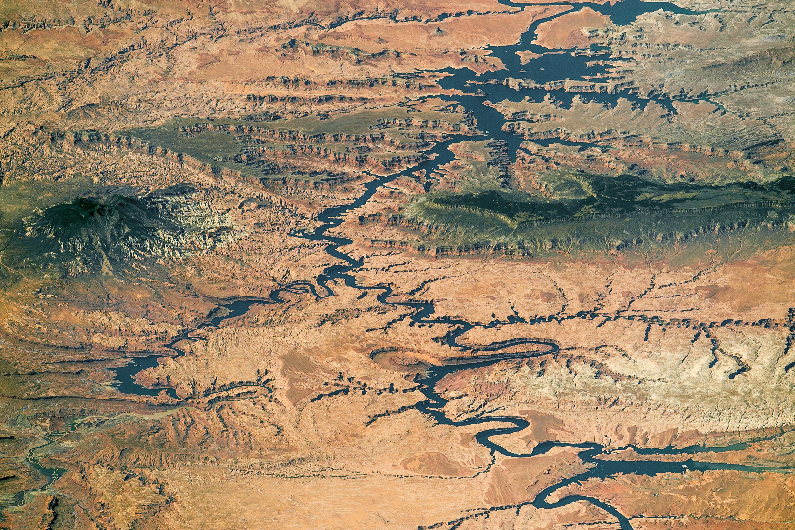
Nearly the full length of Lake Powell on the Colorado River in southern Utah and northern Arizona is visible in this photograph shot by an astronaut aboard the International Space Station, on Sept. 6, 2016. The view is toward the southwest. Water flow is from the lower right toward the top. (Source: NASA Earth Observatory)
Almost the entire lake is visible in this photograph, taken by an astronaut aboard the International Space Station last September. I was really struck by the clarity, the color, and the oblique angle at which it was taken. The photograph almost looks like it was taken from an aircraft — not from orbit almost 25o miles above the surface.
“Climate Change and the Upper Dolores Watershed, a Cold Water Fishery Adaptive Management Strategy,” is an extensive three-year analysis done in cooperation with the Mountain Studies Institute in Silverton.
The study used 72 climate models to tease out potential impacts to 46 trout streams in the basin from the town of Dolores to Lizard Head Pass up to the year 2100.
“We know there will be change, the question the study addresses is what kind of change can we expect, the approximate timing, and what are the impacts,” said Duncan Rose, director of the Dolores River Anglers chapter of Trout Unlimited.
When climate scientists ran the models over time, they pointed toward a “feast and famine” scenario, where wet periods with higher temperatures are followed by longer, more intense droughts.
According to the study, between 1949 and 2012, the upper Dolores watershed experienced wet periods with increasingly higher temperatures, followed by dry periods that were longer and more intense.
“We see that pattern developing where each drought gets more intense, and the wetter periods have higher temperatures, which causes increased evaporation and overall net loss of moisture,” Rose said.
If cyclical drought conditions were like 2002, the worst in recent years, and lasted for many years, the result could mean an average of 44 percent reduction in stream flows throughout the upper basin in 50-70 years, according to the study. Low stream flows contribute to higher water temperatures, which if reach above 63 degrees, are detrimental to trout species.
“Trout have survived these cycles for millennia, but the climate conditions may be more intense than what we have seen, so we’re going to have more challenges, particularly on the lower elevation streams,” Rose said.
The study is intended to aid current and future managers of Colorado Parks and Wildlife and the San Juan National Forest in sustaining good trout habitat in the basin.
For example, higher elevation streams will be less impacted by the climate predictions. Lower trout streams may be more or less a lost cause, with many perennial streams potentially becoming intermittent or drying up completely.
“That leaves the middle elevation band of streams, where mitigation and stream rehabilitation will do the most good,” Rose said. “It’s an adaptive management model, where we don’t rush in, take it a step at a time and invest limited resources with what climate pattern emerges.”
Protecting trout streams from higher temperatures and lower flows means improving shade, installing instream rocks and trees to create pools where fish can find refuge in lower flows and hot conditions. Streams like Roaring Fork, Scotch Creek, Kilpacker, Burnett, and higher-up stretches of the Dolores Main stem, plus others, would likely benefit the most from habitat improvement in the future.
More regulations may by on the horizon, as a result of the study’s projections, for example, lower bag limits, catch-and-release only rules, barbless hooks, and even rotating some streams into non-fishing status for a year to allow recovery.
The climate models indicate there will likely be a reduction in the 295 miles of trout streams in the upper Dolores Basin in the next 50 to 100 years. More of the fishing spots will be concentrated in the higher elevations, which would result in more people fishing in a smaller area.
“There will be more competition for fewer fish, but the good news it will not happen overnight,” Rose said. “We have time to adapt, as long as we are aware of the potential impacts.”
This summer, the Dolores chapter of Trout Unlimited will be installing eight temperature gages on various streams and rivers at different elevations to start monitoring changes and trends.
The Dolores River climate change study cost about $20,000 with $15,000 paid for by the Colorado Water Conservation Board. Other groups, including TU, Southwestern Water Conservation District and the Montezuma Land Conservancy contributed funds as well.
The rule of thumb is that 10 inches of snow contains the water equivalent of one inch of water. In other words, if you melted down 10 inches of snow it would produce as much water as if one inch of rain had fallen instead. But like so many other things based on averages, there are wide variations in this rule of thumb and they are very important, making all the difference as the snow melts.
Some snow is very wet with as much as half of the snowflake actually liquid water instead of ice. We have seen plenty of that this winter. With wet snow, 5 inches of snow can produce an inch of water when it melts.
On the other hand, dry snow, our beloved powder, contains very little water with lots of air space between the flakes. It can take 30 inches of very dry, fluffy powder to produce an inch of water.
In a typical winter, we have mixed layers of wet and dry snow on the ground as the spring thaw starts. With a typical mix, the 10 to 1 rule of thumb does pretty well to estimate how much water will come rolling down out of the hills toward us as the snow melts. Depending on conditions, much of it sublimates into the air or soaks down into the water table anyway, so springtime flooding is usually minimal here. Usually.
The thing is, this winter has not been typical. With sparse data to back it up, many weather observers and sportsmen feel that we have had much more wet snow this season than normal. The La Niña watch issued by the NOAA Climate Prediction Center last fall implied that we could be in this situation this spring. Warmer than average temperatures plus higher than average precipitation equals wet snow, and so it seems to have worked out.
How can we get hard data to back up the observations by those in the know about the moisture content of the snow out there? It takes more than measuring the depth; it requires snow water equivalent measurements. Water equivalent measurements are a little more involved than measuring snow depth, but can be much more important to emergency planners trying to prepare for droughts or floods in the spring. In fact in 1997, an unpredicted flash flood in the Fort Collins, Colorado area killed 5 people and did hundreds of millions of dollars of damage. Only 2 inches of rain fell in Fort Collins that day, but no one was measuring southwest of the city where the flood originated and seven times more rain fell.
As a result of the Colorado flood, the importance of widespread precipitation measurement, including the water equivalent of surrounding snow, was realized. Then it was addressed. A network of volunteer observers, called the Community Collaborative Rain, Hail and Snow Network, (CoCoRaHS for short… I guess) was formed. The network began in Colorado, the original Co was for Colorado, not Community, but it has since spread across the US and Canada. Major sponsors of CoCoRaHS include NOAA and the National Science Foundation. Starting next week, when the right equipment arrives from Pocatello, your genial Teton Valley weatherman will be among the CoCoRaHS volunteers in Idaho doing daily snow water equivalent measurements and sending the reports to CoCoRaHS headquarters.
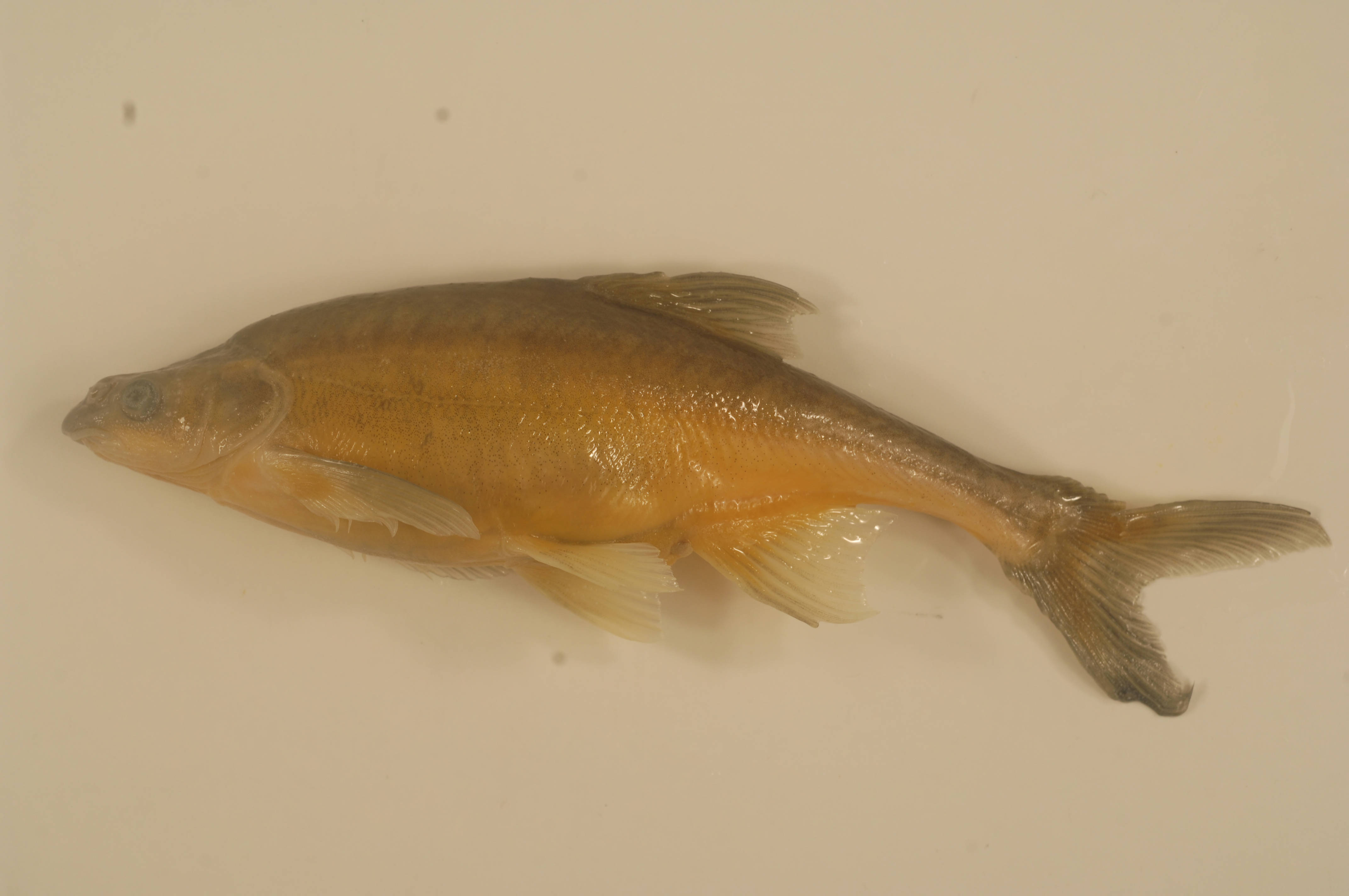
NPS and USFWS personnel use a seine net to trap humpback chubs in the Little Colorado River. Photo credit Mike Pillow (USFWS) via the Arizona Daily Sun.
Thanks to fewer predators and more food at the upriver location, the transplanted fish have come to thrive compared to their downstream brethren, making for a conservation success story that just received national recognition.
The fish-moving process, called translocation, is headed up by a team from the U.S. Fish and Wildlife Service with help from the Arizona Game and Fish Department, the U.S. Geological Survey and the National Park Service. The team received the Fish and Wildlife Service’s 2016 Rachel Carson Award for Exemplary Scientific Accomplishment for its contribution to the recovery of the endangered humpback chub, a distinctive and well-known pillar of the Grand Canyon ecosystem…
Humpback chub congregate in the lower part of the Little Colorado, close to its confluence. Before translocations started the species hadn’t been found above a natural travertine dam 14 kilometers upriver. But that stretch of the river, above what’s called Chute Falls, has warmer water, abundant food sources like insects and the tiny speckled dace and far fewer predators, which for the chub include invasive trout and catfish. Like an in-stream fish hatchery, the area makes for an ideal natural rearing habitat that comes with less disease transmission and genetic challenges, said Randy Van Haverbeke, a senior fish biologist with the Fish and Wildlife Service who is involved in the work. Seeing an opportunity to expand the chub’s range and establish another aggregation that could contribute to the population downriver, biologists started translocating humpback chub above Chute Falls in 2003 and now move about 300 baby fish annually, said Mike Pillow, a biologist with the U.S. Fish and Wildlife Service.
More than a decade in, biologists have consistently measured increased growth and survival among the translocated chub compared to non-translocated chub, indicating promise for the conservation tactic to augment the species’ populations in Grand Canyon, Van Haverbeke said.
In the area above Chute Falls, biologists have recaptured an average of 24 percent of fish translocated the year before, Pillow said.
In the bigger picture, he said, the project’s goal is to build up humpback chub numbers to enable the eventual delisting of the species.
Going beyond the Little Colorado River, the translocation process has been replicated by officials at Grand Canyon National Park as well, where chub from the Colorado River were transported up Havasu and Shinumo creeks. The goal was the same: to establish new population groups of chub within the species’ ancestral habitat where they may be better able to survive. Doing so in more locations creates redundancy, so if something were ever to happen in the Little Colorado River “all our eggs aren’t in one basket,” Van Haverbeke said.
Biologists with the National Park Service have seen as much as a five to 10-fold increase in chub in the mainstem of the Colorado River below those two creeks, suggesting translocation is having a positive impact, he said.
Measurable impacts on total chub population numbers in the Little Colorado River are harder to determine because the population is bigger and the fish are affected by other factors like the temperature of water releases from Glen Canyon Dam, Pillow and Van Haverbeke said.
“But the bottom line is we have increased survival and growth rates compared to not translocating (the fish). Then you have to assume it’s a positive (impact),” Van Haverbeke said.
Also important to note is the fact that this is a feasible, doable conservation action proven to help the fish, as opposed to something much harder to influence like modifying dam operations, he said.
The process also involves relatively minimal human impact, Pillow said, instead helping Mother Nature with “little nudges.”
Humpback chub photo credit US Fish and Wildlife Service.
The public is invited to an open house on the Northern Integrated Supply Project, or NISP, from 5 to 7 p.m. Feb. 13 at the Lincoln Center, 417 W. Magnolia St.
The open house will provide information regarding a proposal by Fort Collins staff members to explore the potential for negotiated outcomes for NISP with Northern Water, the primary proponent of the…project…
Fort Collins has not supported the project as described in a draft Environmental Impact Statement for several reasons, including its potential impacts on city water facilities and the health of the river through the city.
City staff members have proposed discussing mitigation for the project with Northern Water officials and possibly entering into negotiations…
City Council is scheduled to consider staff’s recommendation during its Feb. 21 meeting.
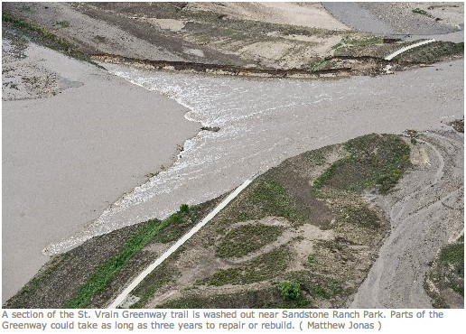
St. Vrain Greenway Trail washout September2013 via Longmont Times-Call
Here’s the release from the USACE Omaha office (Jeff Bohlken):
An open house to share details about a flood risk management study between the U.S. Army Corps of Engineers Omaha District and the City of Longmont will be held from 4:30-6:30 pm (MST) Thursday, Feb. 16, at the Longmont Museum, 400 Quail Road in Longmont, Colorado.
The flood risk management study will build on Resilient St. Vrain, Longmont’s extensive, multi-year undertaking to fully restore the St. Vrain Greenway and improve the St. Vrain Creek channel to mitigate future flood risk to the community. The Resilient St. Vrain project was created in response to the catastrophic flooding that damaged much of Longmont in September 2013.
The open house, which will also serve as a public scoping meeting per the National Environmental Policy Act (NEPA), will give residents and others interested in the project a chance to learn why the study is important, learn what will be done during the study process, learn about the possible benefits, and provide specific concerns and input.
Through the study, the Omaha District will analyze conditions within a portion of the St. Vrain Creek’s city reach. The study area consists of the St. Vrain Creek and surrounding area between Golden Ponds Park (at the upstream confluence of the St. Vrain Creek and Lykins Gulch) to the BNSF railroad bridge (near the pedestrian bridge that connects Price Road). The study will evaluate the engineering feasibility, economic benefits, and environmental considerations for potential flood risk management improvements within the study area.
If a qualifying segment is identified within the study area, the Omaha District could ultimately partner with the City to complete a construction project as part of the Section 205 program of the Flood Control Act of 1948.
For more information, contact Jeff Bohlken with the Omaha District at (402) 995-2671 or Longmont Floodplain Administrator Monica Bortolini at (303) 651-8328.
Here’s the release from the NRCS (Brian Domonkos):
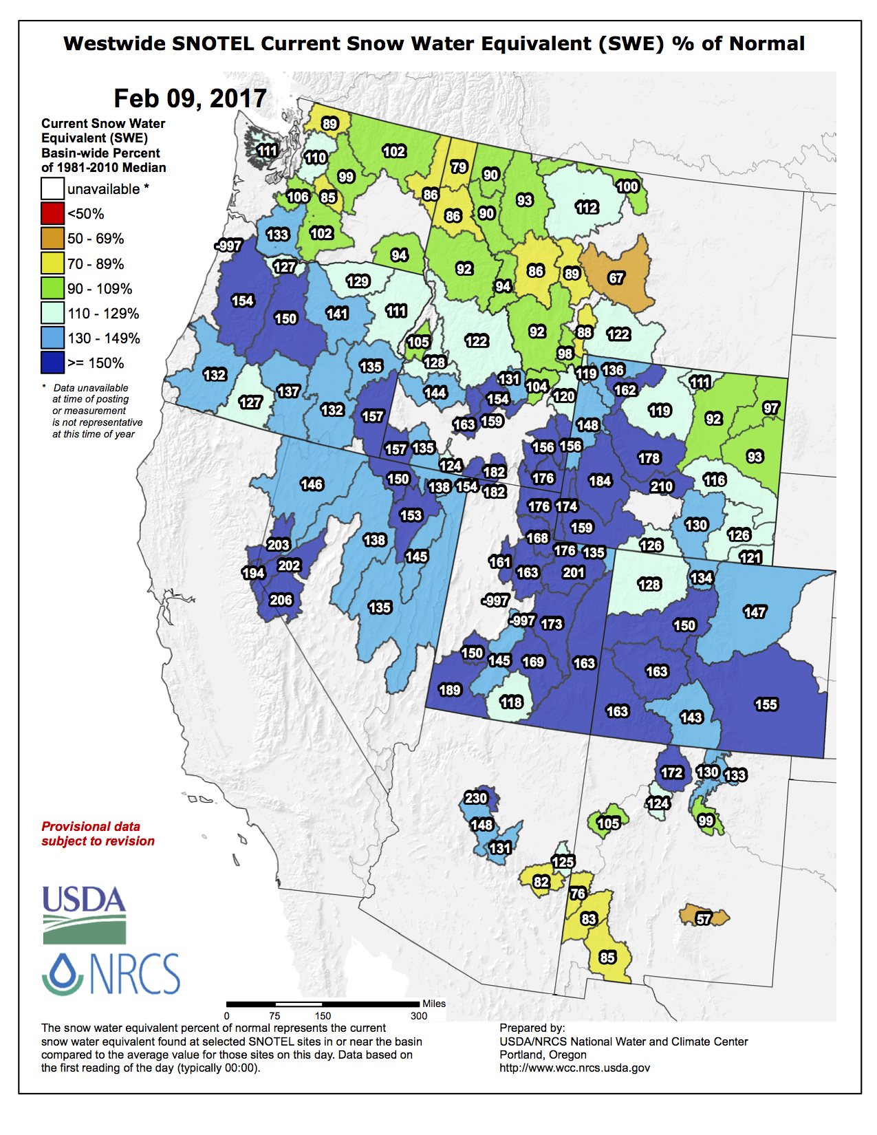
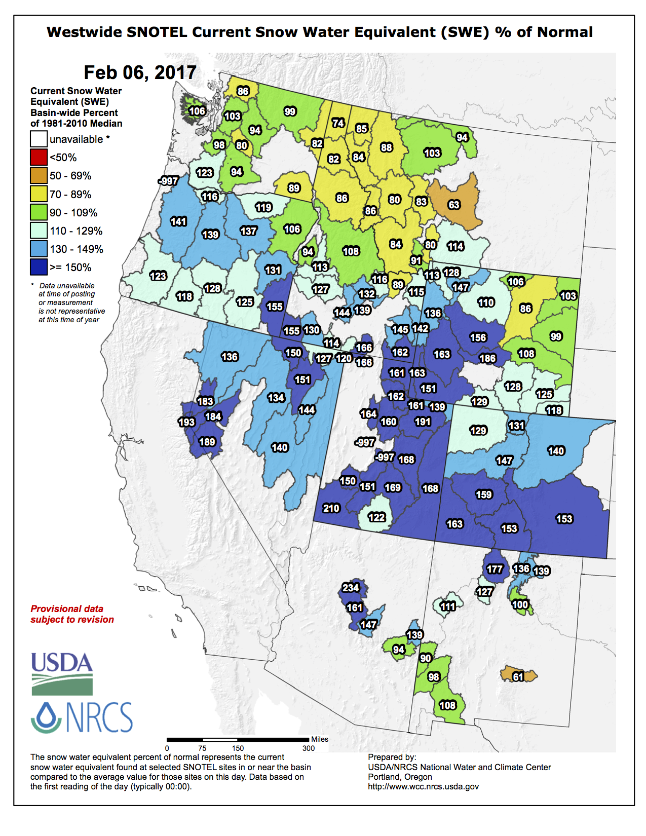
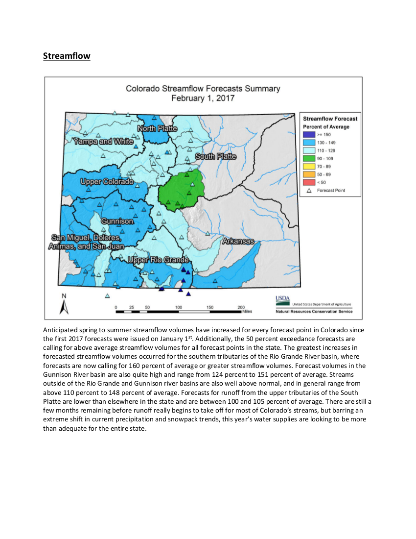
Calendar year 2017 started out with more than twice the normal amount of January precipitation falling across the mountains of Colorado, at 217 percent of average statewide. This month of substantial precipitation was also reflected in the snowpack, which rose from 114 percent of normal on January 1st to 157 percent on February 1st. Nine Colorado SNOTEL sites were holding their maximum snow water equivalent (SWE) on record for February 1st and 10 more had their second highest. As of February 5th, mountain snowpack was already 93 percent of its normal seasonal peak which generally occurs in early April. “While there is still a lot of winter left, this substantial January precipitation has put the Colorado snowpack at well above normal levels and well within reach of achieving at least normal peak values, even if below normal precipitation occurs over the coming months” noted Brian Domonkos, Snow Survey Supervisor for the Natural Resources Conservation Service.
Streamflow forecasts across the state also reflect these well above average snowpack conditions, with all forecast points in the state predicting near to well above normal seasonal streamflow volumes. Values range from a low of about 100-110 percent of average for several points in the South Platte basin to as high as 175-185 percent of normal for some streams in the Upper Rio Grande basin. Across the rest of Colorado forecasts generally range between 110-150 percent of their average seasonal volumes. Reservoir storage across the state has remained relatively constant across the state throughout this water year to date. Statewide, reservoir storage is 106 percent of average with storage in all basins ranging between 89 and 121 percent of average, with the Rio Grande continuing to be the only basin in the state with notably below average storage.
Providing an overview of Colorado’s current water supply situation Domonkos went on to say, “Given current snowpack, water year precipitation, and reservoir storage conditions Colorado is well positioned to have above average water supply available this summer season.” Expanding further, Domonkos also notes “However, it must be kept in mind that a lot can change over the coming months, and while a large snowpack can be good for water availability it can also increase the possibility of flooding.”
For more detailed and the most up to date information about Colorado snowpack and supporting water supply related information, refer to the Colorado Snow Survey website at:
Here’s the release from Colorado State University (Jim Beers):
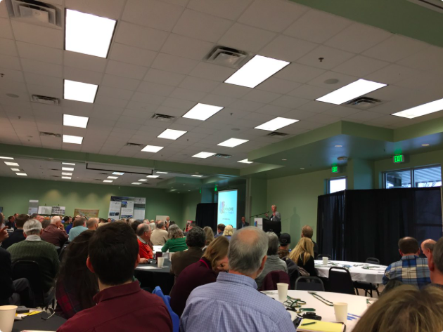
The fourth annual Poudre River Forum, which took place Feb. 3, brought together users of the river to hear about and discuss its challenges and victories. This year’s Forum was held in Greeley for the first time, drawing close to 300 participants representing agricultural, municipal and environmental interests.
The Cache la Poudre River begins in the mountains west of Fort Collins and empties into the South Platte River just east of Greeley. Along its route, the river provides drinking water to more than 365,000 people, irrigates crops and lawns, and is the site of many recreational activities. The forum focuses on building collaborative relationships and understanding among the rivers’ users and those concerned about its health.
The diverse audience heard from several experts during morning sessions that centered on healthier forests and their relation to water availability and quality, a cutting-edge water budget approach to residential water billing just launched by the City of Greeley, and a State of the River ecological report card for the river as it flows through Fort Collins.
Setting sustainable limits
The Forum’s keynote address came from Brian Richter, chief water scientist for The Nature Conservancy. Richter said that communities in the West could have reliable water supplies as long as they set sustainable limits. He said ways to decide those limits include engaging in community visioning, determining water availability, meeting ecological needs, and hedging against climate change. He also advocated that Western states reduce consumption by working to increase efficiency, thus creating more water availability in cities where outdoor landscaping consumes most of the water. Agriculture can do its part too, according to Richter. He cited cases in which ag producers have conserved water by switching to drip irrigation and shifting to planting less water intensive crops. Richter, author of Chasing Water, said that water trades among rights holders could help to avoid “buy-and-dry” scenarios where cropland is dried up as water rights are transferred to municipal or other uses.
Changing water uses
Afternoon sessions included one that focused on adapting to change. Along the Poudre River, change is the result of increasing urban populations, climate variabilities, water availability and fluctuations, and changes in land use. Speakers representing an irrigation company, an environmental group and a municipality all said that they believe that, though change is inevitable, effective management and collaboration can help to manage the change that is coming.
The daylong forum concluded with a breakout session facilitated by Martin Carcasson, professor of Communications Studies and director of CSU’s Center for Public Deliberation. Carcasson asked participants to respond to questions regarding the Poudre: what they most value about it, what is most concerning to them about it, and others. Attendees then met in small groups to discuss the results, and ways citizens can further collaborate to ensure the Poudre remains a healthy, working river.
A majority of participants said that they feel positive about increasing understanding between the agricultural and environmental sectors over the past few years as a result of the annual event. The forum was organized by the Poudre Runs Through It Study/Action Work Group and the event was facilitated by the Colorado Water Institute, a unit within Colorado State University’s Office of Engagement.
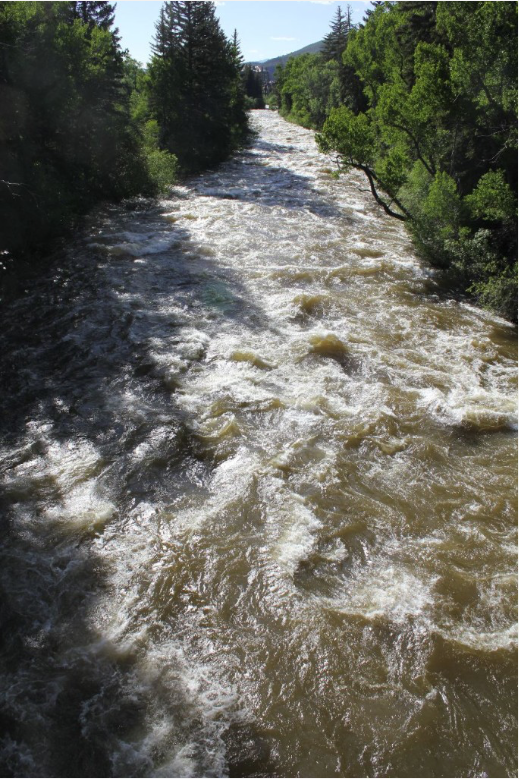
The Eagle River roils with spring runoff in June 2011 near Edwards, Colo. Photo/Allen Best
Click here to read the newsletter. Here’s an excerpt (Lizzie Schoder):
This past year will likely break 2015’s mark of being the hottest year on record. Colorado has seen a similar trend, with a 2 degrees Fahrenheit bump statewide in the last 30 years. Colorado, like much of the Southwest, has also seen drought for the past decade, which has been felt most strongly in the western part of the state.
How does this affect our rivers? A warmer atmosphere has a drying effect overall — meaning more precipitation falls as rain rather than snow and peak runoff and snowmelt happen earlier in the year. Although there is no significant change detected (so far) in the amount of precipitation, the change in the form of precipitation is what’s significant. Our snowpack levels, measured in snow water equivalent, act as nature’s time release to recharge our rivers. Less snowpack, or more precipitation that falls instead as rain, means less natural recharge, since rain runs through the watershed at a quicker rate.
The National Oceanic and Atmospheric Administration reports show trends of peak runoff and snowmelt occurring anywhere from one to four weeks earlier in the spring. Rain is an immediate surge to our rivers, but can give way to evaporation during hotter months of the summer. Snow, on the other hand, melts slowly, recharging the rivers at a steadier pace, especially during July and August when we need it most. Though predictions of how this will affect annual runoff vary, the 2011 Bureau of Reclamation report estimates that Colorado River flows will decrease by about 8.7 percent by 2060, or roughly the annual amount diverted by canal to Los Angeles, Orange and San Diego counties. These trends along with increased evaporation due to warmer temperatures does not bode well for a region already dealing with prolonged drought.
Snowpack levels are a pivotal factor in ski communities. But it matters too for agriculture, irrigation, hydropower, river recreation and water quality. Lower water levels lead to shallower and therefore warmer rivers, affecting our plant and fish populations, as well as the aquatic bugs they need for food. Warming temperatures also mean that everything from crops to humans will need more water to compensate. The Colorado River supplies water to 40 million people in seven different southwest states. The rising temperature trend will only put more pressure on an over-allocated system, pushing both the supply and demand of the Colorado River in the wrong direction.
While communities that depend on the Colorado River have gone to extraordinary lengths to buffer the impacts of climate change, we are heading for times where water shortages will be felt more than ever. According to the New York Times, Lake Powell provides water to one in eight Americans and waters one-seventh of the nation’s crops. Like the other dams and reservoirs in the Colorado River system, it’s completely over allocated — the water levels continue to dwindle and more water is being taken out than what flows into it. If Lake Powell isn’t able to supply the 7.5 million acre feet annually to the Lower Colorado Basin as required by the 1922 interstate compact, then a river call requiring Upper Basin communities, such as Eagle County, to use less water could come into effect in coming years.
The national political debate over the legitimacy of climate change will inevitably continue. But with our county’s population projected to nearly double by 2050, we must recognize that water is a nonpartisan issue. It is important that we voice our opinions and demand action at the national level, while also encouraging action at state and local levels where it can likely happen more quickly. From the standpoint of water and river protection however, we do not need to stand around waiting for our leaders to reach consensus on the existence of climate change.
There is no arguing that the level of water in Lake Powell — and its sister, Lake Mead — continue to drop, making it clear that water conservation and efficiency is of critical importance. That can happen through legislative actions, regulatory measures, but also where you can make an impact — in your home and garden. For more information, visit http://erwc.org.
Lizzie Schoder is the education and outreach coordinator for Eagle River Watershed Council. The Watershed Council has a mission to advocate for the health and conservation of the Upper Colorado and Eagle River basins through research, education and projects. Contact the Watershed Council at 970-827-5406 or visit http://www.erwc.org.
Parachute/Battlement Mesa area via the Town of Parachute.
From the Glenwood Springs Post-Independent (Alex Zorn):
The well location, the staff said, “will have unreasonable adverse effect on the surrounding area, including the safety of the Battlement Mesa Metro District public water supply intake,” which is roughly 600 feet from the area proposed for rezoning.
The well is on the agenda for Wednesday’s Planning Commission meeting, to decide whether to create a new zone district that would allow injection wells in Battlement Mesa under a special use permit.
The zone would be called the “Public Service, Recreation and Injection Well” zone and would set aside 37 acres along the north end of the community by the Colorado River.
Since Ursa Resources owns the mineral rights beneath Battlement Mesa, the company won approval last year from state regulators to develop 53 natural gas wells within the residential boundaries of Battlement Mesa. Injection wells, though, used to dispose of wastewater from the drilling process, are currently not permitted within Battlement Mesa.
The proposal for changes to the unincorporated area’s zoning map has seen strong opposition from community activist groups throughout Garfield County.
“We’re ecstatic about the staff rejecting the injection well permit application, but we know the members of the Planning Commission and the county commissioners are the real deciders, “ said Leslie Robinson, president of the Grand Valley Citizens Alliance. “The Planning Commission and county commissioners have their own agenda when it comes to oil and gas, so I don’t know how they will lean.”
Robinson said that she remains apprehensive heading into the vote because the county commissioners have consistently voted to approve oil and gas activities over citizen concerns.
“We just don’t know if staff arguments will be strong enough to persuade the Planning Commission, but it was definitely a pleasant surprise,” she added.
The staff report cites comments from the Colorado Department of Public Health and Environment last February as evidence.
“The proposed location is not well located and safe as reflected in referral comments from the Colorado Department of Public Health and Environment (CDPHE) identifying risks to the Battlement Mesa Metro District public water supply intake,” the staff report states.
The letter has been consistently referenced by opposition of the injection well as the bid has progressed.
“The department believes it creates a significant contamination risk to the public water supply for Battlement Mesa,” the letter said. “The department believes Class II injection wells should not be located in urban mitigation areas.”
Asked about the letter last month, Ursa Vice President of Business Development Don Simpson said he didn’t believe it held much weight because of all the changes the company has made to the proposed well since then. Asked about it again Monday in light of the staff recommendation, Simpson said he believed changes to the proposed pad sufficiently mitigated risk.
“We’re a little surprised [by the staff comments] and intend to have more discussion on our plan, and we’ll see what happens,” he said.
“We’re always looking to improve our project if we can,” he said. “We’re going to talk it out on Wednesday and see if we can come up with a solution.”
The report, which was released late last week by the Garfield County Community Development Department staff, identifies many concerns with the proposed injection well that have been laid out by opposition within Garfield County.
“I wasn’t really surprised by the staff’s decision,” said Dave Devanney of Battlement Concerned Citizens. “In a lot of ways it’s a common sense decision because you just don’t put waste removal within a community.
“I’m just happy that they have taken this position and hope it will be taken into consideration by the county commissioners,” he added. “I’ve been doing this enough that I never get too confident.”
FromThe Grand Junction Daily Sentinel (Dennis Webb):
Ursa Resources has begun the process for seeking approvals to drill 74 oil and gas wells from three pads in a second phase of drilling in the community of Battlement Mesa, while also hitting new resistance to its hopes of operating a wastewater injection well from a previously approved pad near the Colorado River.
Garfield County commissioners on Monday agreed to invoke its rights under new state rules to consult with Ursa about locations and measures to reduce impacts associated with the three additional pads.
Ursa previously received approval to drill more than 50 wells from two pads in the unincorporated community of several thousand people, but hasn’t yet begun drilling. It’s also hoping to operate the injection well on one of those two pads. But the Colorado Department of Public Health and Environment, and now Garfield County’s planning staff, have recommended against approval of a zoning change proposal by Battlement Mesa’s developer to allow injection wells on 37 acres, which would take in an approved Ursa pad and a proposed one.
A county planning staff document says Battlement Mesa’s public water intake from the Colorado is 600 feet west of the area proposed for rezoning.
Injection wells also would require approval by the Colorado Oil and Gas Conservation Commission. A CDPHE official recently reiterated to the county its past recommendation against approving an injection well from the approved Ursa pad near the intake because of the threat the well and associated storage tanks would pose to it.
Garfield County’s planning staff pointed to the CDPHE’s concern in urging the county planning commission to recommend to Garfield commissioners that they deny the injection well zoning.
“The proposal will affect in a substantially adverse manner the public interest by creating a risk to the Battlement Mesa Metro District public water supply intake,” the planning staff said in their recommendation.
The planning commission will consider the zoning change Wednesday night.
In a letter to the county, the metro district referenced the CDPHE recommendation that alternative locations for an injection well be analyzed, and said it hadn’t had the chance to conduct an expert evaluation of the potential impacts of an injection well close to the intake.
The county’s oil and gas liaison, Kirby Wynn, recommended that the planning commission give strong consideration to health department comments, and Garfield County Environmental Health also pointed to the potential risks to the water supply and potential benefits of other sites farther away.
Dave Devanney, with Battlement Concerned Citizens, appreciates the position taken by the county planning staff and others. While activists in the community oppose oil and gas development in Battlement Mesa more generally, Devanney said that the idea of pumping wastewater underground near the river and intake “is kind of a line in the sand that they just can’t tolerate.”
Tracking what is happening with snow is important to the state’s water supply. The mountain snowpack ensures plenty of water filling reservoirs. The water supplies communities on the front range as well as agriculture happening out on the plains.
An extra snowy January piled up snow in the mountains150 percent of normal for this time of year. “A lot of really wet snow for January, we usually see these types of snow more in the March time frame,” said Colorado Springs Utilities, Water Resource Supervisor, Abby Ortega.
On the plains, snow so far has been scarce. It means little water soaking into the ground. That can end up causing higher demand on water supplies saved from all the mountain snow.
“We’re hoping that the spring brings a little more moisture to the Front Range and eastern side of Colorado, which will certainly help,” said Ortega. It is only midway through the winter tracking season and a lot can happen in the next couple of months out on the plains. March and April are important months often bringing heavy wet snow.
Heavy snowfall on Colorado’s Western Slope and Utah’s Wasatch Range in December and January boosted snowpack in the five-state Upper Colorado River Basin to 157 percent of average.
Increased spring runoff in the drainage area will make boat launch ramps more accessible and continue to help shore up the shrinking reservoir of [upstream] Lake Mead. The U.S. Bureau of Reclamation is projecting unregulated inflow to reach 126 percent of average…
But this winter started so vigorously as to rekindle memories of a “full pool” at Lake Powell. Before the drought, the surface elevation regularly approached 3,700 feet above sea level. At the depth of the drought, in 2005, the lake level dipped to 3,555 feet…
To reach 3,700 feet again, the lake would need four to five years of significantly-high inflow, assuming that many other variables line up perfectly during the period, said Marlon Duke, a spokesman for the Bureau of Reclamation in Salt Lake City.
The lake was measured this week at 3,595 feet. Last year it peaked at 3,621 feet in July. The average elevation for the life of the reservoir is 3,640 feet. The biggest single rise in recent years came following the 2005 low point, when the lake came up 50 feet. Ostapuk speculated that at least a 40-foot rise appears likely this spring.
Even if Lake Powell doesn’t rise to 3,700 feet in the near future, the reservoir is doing its job, said Ostapuk: “Lake Powell was never expected to operate permanently at full pool.”
“The reservoir has done its job quite well in dry years,” BOR’s Duke said last week. “There haven’t been any instances of shortages, due to its ability to store water.”
Complicating a movement toward full pool is the critical nature of downstream Lake Mead. The nation’s largest artificial lake continues to struggle during the drought to meet the needs of an increasingly thirsty population in the lower basin states of California, Nevada and Arizona. Mead has lost more than 100 feet in surface elevation since 2000 and is only 40 percent full.
If Lake Powell should build to 160 to 200 percent of average inflow — and reach 3,652 feet by August — a higher level of equalization with Lake Mead could be triggered, requiring Glen Canyon to boost releases from its current 9 million acre feet annually, Ostapuk said. The dam could increase to perhaps 11 MAF or 11.5 MAF under that scenario, he said…
The 30-day outlook of the National Oceanic Atmospheric Administration calls for February temperatures well above normal in the southern end of the basin. The forecast also projects precipitation near average in the northern end of the basin and slightly below average in the southern end.
Click here to read the newsletter. Here’s an excerpt:
Justin Ramsey Takes Over as PAWSD Manager
In January 2017 the PAWSD Board of Directors promoted Justin Ramsey to District Manager, replacing Renee Lewis. Mr. Ramsey had served as the District Engineer since May 2015. He has over twenty years of water and wastewater design and construction administration experience. Mr. Ramsey has a Bachelor’s of Science degree in Environmental Engineering and a Masters of Engineering in Civil Engineering both from Northern Arizona University. He is a registered professional engineer in four states and has designed and overseen the construction of water and wastewater treatment, conveyance and disposal facilities throughout the southwest.
Prior to coming to PAWSD, Mr. Ramsey lived and worked in Arizona and sat on the City of Flagstaff’s Water Commission where he reviewed and provided recommendations on a variety of utility assessments including capital improvement project budgets, inflow and infiltration studies, water leakage studies, rate studies and energy audits. Mr. Ramsey has also consulted with multiple regulatory agencies to provide training, develop regulations and represent agencies in a variety of venues. Congratulations, and welcome!
[The new President’s] rocky relations with Mexico could have major consequences for the Colorado River and the 35 million Americans who rely on it for water…
A bilateral agreement specifies exactly how much water Mexico receives, as well as other important factors like how those deliveries are reduced in years of exceptional drought.
It is set to expire this year.
The seven Colorado River Basin states — and particularly Lower Basin states Nevada, Arizona and California — say it’s pivotal that the new administration finalize a new agreement.
But many are now worried that U.S.-Mexico relations have already deteriorated to the point where that may be impossible.
“The events of this week make me more apprehensive about the prospects” of reaching a new agreement, said Anne Castle, a former assistant secretary of the Interior for water and science during the Obama administration.
She said a challenge for the new administration is separating the Colorado River issues between the United States and Mexico, which Castle described as a “win-win,” from other binational issues.
“There seems to be a demonizing of Mexico in general that is becoming more difficult to overcome,” she said.
A 1944 treaty between the two countries requires the United States to deliver 1.5 million acre-feet of Colorado River water to Mexico annually. It said that amount can be reduced during times of exceptional drought, but it did not define what an exceptional drought is, or how much those deliveries could be curtailed during one.
Amendments to the treaty have since clarified. The current one, 2012’s Minute 319, laid out those terms. It tied the deliveries to the volume of water in Lake Mead behind the Hoover Dam, America’s largest reservoir and the primary storage facility for the Lower Basin states. It also allowed Mexico to store water in Lake Mead.
Minute 319 expires at the end of 2017, which has led to negotiations over a new amendment commonly referred to as Minute 32x.
All parties in the Colorado River Basin say it is critical that Minute 32x be finalized. It would again set the terms of water delivery and define exceptional drought.
That’s particularly important now because the basin is in the midst of a 17-year drought. Further, scientists estimate there is a 50-50 chance that Lake Mead will drop below an elevation this year that would trigger drought contingency conditions along the river, including reduced deliveries.
Defining those terms with Mexico and allowing it to store water in Lake Mead — which would help keep the lake above the 1,075-feet elevation trigger point — are critical. The Obama administration worked hard to finish the negotiations but ran out of time, Castle said.
Then, last week, [the new President’s] relationship with Mexico got off to a shaky start. Mexican President Enrique Peña Nieto canceled a planned meeting over [the new President’s] plan to build a wall between the two countries amid suggestions that Mexico would pay for it through a 20 percent import tax on Mexican goods.
Since [the new President’s] election, Mexico has also replaced its foreign minister and U.S. ambassador, both of whom had been intimately involved in the Minute 32x negotiations.
Those developments have alarmed key Colorado River players.
“Reports the last couple days are not the kind of footing that you would expect to provide a really good foundation for these talks,” said James Eklund, director of the Colorado Water Conservation Board.
Failure to finalize Minute 32x would have important consequences.
Tom Buschatzke, director of the Arizona Department of Water Resources, said the current minute proposal would define Mexico’s shortages in a drought and make them proportional to how much Arizona must curtail its use. Arizona relies on the Colorado River for about 40 percent of its water.
“There are many, many terms of Minute 32x that are hugely beneficial to the state of Arizona,” he said. “This is a very positive thing.”
If there is no new agreement, several problems could occur. For example, if Lake Mead hits the 1,075-feet trigger, the United States could decide unilaterally to begin reducing the amount of water that reaches Mexico. Such a decision could have “broad geopolitical implications,” according to a white paper from the Colorado River Future Project based on interviews with 65 key players that was released shortly before the election.
Salton Sea a sticking point
There are other Colorado River issues on which the Trump administration needs to play a leading role, observers say.
Before Minute 32x can be finalized, the seven basin states — and particularly the Lower Basin states — need to finalize a drought contingency plan, or DCP, for what happens if and when Lake Mead drops below 1,075 feet.
The Obama administration worked toward finalizing that document but similarly came up short. If an agreement isn’t finished, the stage could be set for litigation and conflicts between the states if Lake Mead drops.
Recently, California’s largest lake, the Salton Sea, has become a sticking point in the DCP negotiations.
The Salton Sea lies in the Imperial and Coachella valleys in the southeast corner of the state. The lake was once a tourist hot spot, but a complicated 2003 water transfer from the agricultural area surrounding the lake to San Diego has significantly reduced inflows to the lake, causing it to dry up.
As the lake has receded, it has exposed a massive lake bed that emits toxic dust during windstorms, creating a major public health risk. And under the terms of that agreement, water flowing into the lake will again be reduced by the end of 2017.
At the time of the agreement, California vowed to take action to address those public health concerns. In nearly 15 years, however, it has done very little (Greenwire, June 13, 2016).
Agricultural water that eventually flows into the Salton Sea comes from the Colorado River. And the Imperial Irrigation District, or IID, which represents those users, is a major player in the DCP negotiations because its users have water rights to 3.1 million acre-feet of the river’s water. That’s more than all of Arizona…
IID says it won’t sign onto a DCP until it sees a plan from the state to address air pollution at the Salton Sea.
“For IID to take part in a DCP for the Lower Basin,” said IID General Manager Kevin Kelley, “we’re going to have to know that we’ve got a coherent going-forward plan for at least the next 10 years.”
California is working to come up with such a plan, according to state officials. But a big problem is cost. California has set aside about $80 million for mitigation efforts in its most recent budget, and the Obama administration pledged another $30 million before leaving office.
But most expect mitigating the likely 38,000 acres of exposed lake bed to cost at least $1 billion.
That has put IID and the Salton Sea in a critical position for progress on the Colorado River.
“The Salton Sea went from being an issue that was on the back burner for a lot of people to the front of the line,” said Douglas Kenney, director of the Western water program at the University of Colorado’s Getches-Wilkinson Natural Resources Law Center.
“It went from this quirky, very isolated issue to being front and center.”
Despite Trump’s rough start with Mexico, some still see causes for optimism. They note that water should be a nonpartisan issue, and that even the Israelis and Palestinians cooperate when it comes to managing water in the Middle East.
“The shift in politics doesn’t change the fact that the reservoir system in the Colorado system is half-empty,” said Jennifer Pitt of the National Audubon Society, who has been a key player in Colorado River negotiations for years.
“What gives me confidence that there will be a path forward is there are seven states that really would like to see this sort of continued collaboration with Mexico in increasing the reliability of Colorado River water supply.”
For many key players, though, there have been few hints from the new administration about what role it will play.
“The bigger question in the Colorado Basin for a lot of people is not a concern that a [new] administration would come in and try to push some strong agenda, but that the administration might just disappear on Western water issues,” said Kenney.
He noted that the Obama administration was very active in trying to broker these agreements.
We are well into the new year, and I wanted to give you a quick update on screening events for Thirsty Land. I will be attending the following events this week. Please let me know if you’re interested in scheduling a media interview.
Feb. 7, 7:00PM – Monte Vista, CO – Vali 3 Theater – Sponsored by Colorado Potatoes, the Rio Grande Water Conservation District and the Monte Vista Co-op. All ticket and concession proceeds for the night will go directly to supporting the Vali 3 Theater.
Feb. 8, 2017, 5:30PM – Ft. Collins, CO – Colorado State University – Lory Student Center Theatre, Central Avenue Mall, Fort Collins, CO. Sponsored by the Colorado State University Water Center. Join me for a Reception and Meet & Greet at 5:30; we’re also expecting Pat & Sharon O’Toole from the Ladder Ranch to attend. Film screening at 6:30PM This is a FREE EVENT!
Feb. 9, 2017, 6:00PM – Laramie, WY – University of Wyoming – Berry Center Auditorium 1000 East University Ave. Laramie, WY Film screening & Q&A sponsored by the Graduate & Undergraduate Students in Hydrology. The O’Tooles have also planned on attending this event.
Future events coming up:
Feb. 24, 2017 – Las Vegas, NV – Family Farm Alliance Conference
Screening sponsored by the Family Farm Alliance
April 6, 2017 – Manhattan, KS – Kansas State University
June, 2017 – Fresno, CA – AgChat Western Regional Agvocacy Conference
The Colorado Department of Public Health and the Environment required additional monitoring activities after 1,4 dioxane was found in a monitoring well…
According to County Administration Officer Tom Eisenman, CDPHE is requiring one more groundwater monitoring well in addition to the four currently on site.
A revised monitoring plan is due to CDPHE by the end of March.
Neighboring residents were notified last December by BLM that dioxane was found in one monitoring well.
The BLM stated in a memo to the county that CDPHE said the level found at the landfill was too low to cause health problems.
Eisenman said the surrounding groundwater wells on 12 private properties were tested.
One tested positive for dioxane, so a second sample was pulled as well as on an adjacent property’s well. Those results haven’t been received.
Eisenman said the county is providing water to the residents whose well was positive and currently working on a cost analysis of various options to provide a permanent solution for these residents’ well, at the county’s cost.
Landfill history
According to BLM, the landfill was operated from 1967 to Oct. 1993.
According to CDPHE, the closure plan met state requirements at the time it was approved. Since then state regulations have changed.
Waste was deposited into unlined trenches that were about 20 feet deep and regularly burned, according to Doty and Associates, the county’s consultant for the landfill post-closure requirements.
Located in Golden, Doty is an environmental, groundwater and waste management engineering firm.
Eisenman told The Flume that two groundwater monitoring wells were installed in 1991, both several hundred feet from the landfill trenches. They are LF-1 and LF-2 on the adjacent map.
The following history was taken from a 2014 Doty report.
A compliance advisory from CDPHE in 2004, stated the county needed to report groundwater monitoring. In 2006, one sample was tested and contained several volatile organic compounds.
Another advisory sent in 2007, stating groundwater monitoring needed to be implemented and based on the 2006 sampling, explosive gases needed to be identified.
When the state didn’t receive a response from the county, CDPHE conducted a site visit in 2013 and sent a third memo in 2014.
That led to digging excavation test pits both in the landfill and adjacent to it in 2015.
Because gas measurements at the pits showed the landfill is still generating gases, the state is now requiring the installation of gas probes.
The state also required more groundwater monitoring wells in the 2014 memo and implementation of a groundwater monitoring plan.
Doty developed a monitoring plan and two additional wells, LF-3 and LF-4R, were installed by BLM in early 2016.
All four wells were sampled three times in 2016, starting with the second quarter of the year and dioxane was detected in LF-2 and LF-3 in the fourth quarter, according to documentation from CDPHE.
The Flume’s request for copies of the landfill laboratory results was denied by the county.
Eisenman said the county is financially responsible for installing the gas probes and another groundwater monitoring well plus any remediation that is necessary.
According to an online article by Geosyntec Consultants, a world-wide company with two Colorado offices, dioxane removal is very complex and most treatments don’t remove it.
The article stated the process used at one site in Colorado is an advanced oxidation process.
“It has the capability to reduce the dioxane concentration to non-detect levels under the right conditions, but this is likely not achievable for many groundwater matrices,” the article stated.
Advanced oxidation process can include processes using ozone, hydrogen peroxide and/or ultraviolet light to break dioxin into other benign substances.
Research is ongoing regarding the best way to remove dioxane.
The good news
According to the Doty report, the geology in the area indicates that the groundwater found in the monitoring wells are in moraine deposits that were left after glaciers retreated.
These deposits have varying sizes of boulders, cobbles, gravel, sand and silt, usually without any cementing as found in other formations such as sandstone, shale or limestone.
Water can travel through moraine deposits easily.
The report states that the groundwater appears to be a perched aquifer underlain with a reddish clay, probably from a weathered Minturn formation which is a red siltstone.
The clay keeps the groundwater from moving downward, confining it to the depths of the moraine deposits. In the area, the moraine deposits range from 80 to 134 feet.
Aquifers below that may not be contaminated.
Eisenman said the monitoring wells are about 150 feet deep and most private wells in the area use an aquifer at around 250 feet.
The following two sections were obtained the Environmental Protection Agency and National Library of Medicine websites.
What is dioxane?
Dioxane is a synthetic heterocyclic organic compound. This means it is a manmade chemical that contains carbon, hydrogen and oxygen molecules that are connected in a circular pattern.
Dioxane is classified as an ether. It is a colorless liquid with a faint sweet odor. It is flammable; it mixes with and migrates quickly through groundwater.
Dioxane can degrade in the atmosphere into other harmless substances through photosynthesis. But that takes several days.
Health effects of a short term, high dose exposure include nausea, drowsiness, headache, and irritation of the eyes, nose and throat.
Chronic exposure can cause dermatitis and damage to the liver and kidneys. It is considered a possible carcinogen.
The BLM press release stated that according to CDPHE, the amount found in the Park County landfill monitoring well was not high enough to cause health hazards.
Currently, there is no EPA drinking water standard for dioxane. In 2012, EPA established a lifetime health advisory of 0.2 milligrams per liter in drinking water.
Colorado has adopted an interim groundwater quality cleanup standard of .35 micrograms per liter…
Dioxane uses
Dioxane is used as a solvent in paint and varnish removers, a corrosion inhibitor in chlorinated solvents, a purifying agent in the manufacture of pharmaceuticals and is a by-product in the manufacture of polyethylene terephthalate plastic.
It is used as a wetting and dispersing agent in the textile industry.
Traces may exist in food supplements and food containing residues from packaging adhesives or on food crops treated with certain pesticides.
Dioxane can be an impurity in antifreeze and aircraft deicing fluids and in some consumer products, such as deodorants, shampoos and cosmetics.
Board President John Porter and Vice President Steve Fearn, representatives of Montezuma and San Juan counties, respectively, were voted off the board by commissioners in their respective counties.
Fearn, a prominent longtime coordinator of the Animas River Stakeholders Group, has represented San Juan County on the water conservation board since 1990 and served as vice president since 2007.
But San Juan County commissioners said Fearn’s representation no longer reflects county values, which have changed significantly since Silverton’s mining days to include more recreational interests with respect to water, county attorney Paul Sunderland said…
Commissioners voted to appoint Charlie Smith, part-time Silverton resident and eight-year general manager of the Lake Durango Water Authority, as Fearn’s replacement.
“Commissioners thought Charlie Smith would better represent San Juan County,” Sunderland said. “He has a lot of water expertise, and he’s probably more in tune with the wants of the current board. Historically, San Juan County has been largely dominated by mining interests, and Steve Fearn is very much associated with those interests, but the board’s interests have shifted more toward recreation.”
The fact that the state of New Mexico named Fearn in a lawsuit as a “potentially responsible party” for mine pollution in the Gladstone area was noted in the county’s decision, Sunderland said.
“It’s definitely something we’re aware of, given his ownership interests around Gladstone,” he said…
The board consists of nine members representing Archuleta, Dolores, Hinsdale, La Plata, Mineral, Montezuma, Montrose, San Juan and San Miguel counties. Board directors can serve an unlimited number of three-year terms.
“I want to make sure the county’s views are represented,” Smith told The Durango Herald. “I have an understanding of their water rights, and a lot of work needs to be done to secure those rights and make sure the uses align with what the county envisions.”
Montezuma County commissioners selected Don Schwindt to replace Porter, who was general manager of the Dolores Water Conservancy District for 22 years and a Southwestern board director for 26.
Schwindt is a director on the Dolores Water Conservancy District board and a critic of the Dolores National Conservation Area, a controversial proposal in Montezuma County to congressionally protect land and water along the lower Dolores…
Porter thinks the proposal, criticized by Montezuma County commissioners, influenced his removal. Under Porter’s leadership, Southwestern Water Conservation District contributed funds to hire a water attorney to rewrite draft National Conservation Area legislation, which Porter thinks was perceived as support for the bill.
“I perceived the funding as an effort so everyone involved knew all the problems, the facts on both sides and could intelligently make a decision,” Porter said. “I think Southwestern’s involvement was perceived by others that we were very much in favor of the NCA legislation. That had something to do with it, and the fact that I’m 80-plus, and my 26 years on the board.”
Montezuma County Commissioner Larry Suckla said the commission chose Schwindt because of his water knowledge, and the conservation area proposal did not play a part in the decision.
“Don has shown ways that he would save water and retain water for farmers and ranchers,” Suckla said. “John Porter is an icon for Montezuma County. He was involved in the management of the lake (McPhee Reservoir), and all the benefits the county has received from that is because of the work he did, but it felt like it was time for new eyes.”
When Porter joined the board in 1990, he said water storage and dam construction were the district’s primary focus, including such projects as Lake Nighthorse. But gradually, the focus broadened to consider recreational water use and water quality.
Porter refers to his tenure as a career highlight, and said the importance of inter-basin relations and dialogue will only increase as time goes on, water supply dwindles and population grows.
“You’re asking someone who’s biased, but I’ve always felt that the Southwestern board tried its very best to represent all interests,” Porter said. “True, the majority of the members, including myself, were and still are agriculture-oriented. Yet to me, as Colorado’s population grows, it’s inevitable that our water supply will be drying up agriculture. And that’s not in our best interest, but I don’t see a way of satisfying municipal needs that we’re going to have without drying up some ag use. Irrigation takes a lot of water, and just that amount converted to municipal use will take care of a lot of families in an urban situation.”
Colorado River headwaters tributary in Rocky Mountain National Park photo via Greg Hobbs.
Here’s a guest column from Paul Bruchez that is running in Steamboat Today:
A few years ago, I saw an opportunity to fix the irrigation problems while also improving river and wildlife habitat. My family’s ranch is in one of the most intact traditional agricultural communities remaining in Colorado. Like most ranchers, we’re independent folks — but in a pinch, we know we can count on each other.
Our neighbors came together and agreed on the need for action. Our group of 11 private ranches and the Bureau of Land Management, the irrigators of lands in the vicinity of Kremmling, received a couple of grants for a pilot project to restore a riffle/pool structure on a stretch of the river. It was an exciting start.
But I quickly realized that, given the scale of the problems, we needed to think bigger.
We worked with a variety of partners — Trout Unlimited, American Rivers, the Colorado Basin Roundtable, the Colorado Water Conservation Board, Grand County government, Northern Water, Denver Water, Colorado Parks and Wildlife, the Upper Colorado River Alliance, the Colorado River District and other river stakeholders — to put together an ambitious proposal for restoring a significant stretch of the Upper Colorado River.
In December, the U.S. Department of Agriculture’s Natural Resources Conservation Service recognized that big vision, awarding ILVK and our partners $7.75 million under the Regional Conservation Partnership Program to improve irrigation systems and reverse the decline in water quality and fish habitat in the headwaters of the Colorado River.
This funding is an amazing win for all Coloradans, because a healthy Colorado River sustains all our lives.
The Colorado River Headwaters Project will install several innovative instream structures designed to improve water levels for irrigation, while enhancing critical river habitat by rebuilding riffles and pool structure. A crucial piece will be restoring approximately one mile of the Colorado River’s former channel, currently inundated by Windy Gap Reservoir. This ambitious bypass project will reconnect the river — for the first time in decades — and improve river habitat in the headwaters area.
When fully implemented, the Headwaters Project will directly benefit more than 30 miles of the Colorado River and 4,500 acres of irrigated lands and make available up to 11,000 acre-feet of water to improve the river during low-flow conditions.
What have I learned from this project? That the interests of agriculture producers can align with the interests of conservation groups, state agencies, water providers and other river users. It’s not just the waters of the Colorado River that are connected — so are the people who depend on it.
The Colorado River flows through all of our lives. By working together, we can find smart, creative solutions that keep the Colorado healthy and working for all of us.
Paul Bruchez is a rancher who lives near Kremling.
“It’s another storage vehicle,” state Rep. Jeni Arndt, D-Fort Collins, said. “It’s logical, it’s practical. It should be part of our future water plan.”
To that extent, Arndt introduced a bill in the Legislature requiring the state engineer to create rules for artificially recharging these [aquifers]…
The proposal doesn’t jump-start the development of aquifer recharging programs, but it would create the framework for such programs at a state level. Arndt and others said the key is putting in guards against contaminating an aquifer and avoiding entanglements with the water rights of individuals and neighboring states.
It’s not as revolutionary an idea as some may think. Denver Water is working on a pilot program for aquifer storage and recovery and Arizona uses aquifer recharging to prevent undue evaporation in desert climates.
“It’s not really debatable if (aquifer recharging) is proven or not. It is,” said Joe Meigs, a senior project manager with Lytle Water Solutions. “It would be really good if people embraced that and then people tried to move forward with an (aquifer recharge) program to buffer their water supplies.”
Typical use of these programs works like this, he said: Some years have a lot of surface water, such as when high snow totals melt and flow down the Rockies and inundate normal needs. When that happens, some of the overflow is diverted back into the aquifers — after a making sure its clean, of course — where it can be pumped out during low-flow periods…
Brian Werner, spokesperson for Northern Water, said recharging aquifers along the north Front Range wouldn’t be a panacea for Northern Colorado’s future water needs. Northern Water looked at the hydrology of the area and concluded that above-ground storage remains the “biggest bang for your buck.” Northern Water is proposing the controversial Northern Integrated Supply Project, which would include construction of the Glade and Galeton reservoirs in Northern Colorado.
The Bolts Ditch Access and Use Act would authorize special use of the Bolts Ditch headgate and the segment of the Bolts Ditch within the Holy Cross Wilderness Area, allowing Minturn to use its existing water right to fill Bolts Lake. This would solve a problem created in 1980 when Congress designated Holy Cross Wilderness area, but inadvertently left Bolts Ditch off of the list of existing water facilities.
The Florissant Fossil Beds National Monument legislation will allow for enhanced wildfire protection as well as additional habitat for wildlife and recreational opportunities for visitors. Established as a national monument in 1969, the Florissant Fossil Beds National Monument is located west of Pikes Peak and less than 40 miles from Colorado Springs. The monument is home to diverse fossil deposits, maintaining a collection of over 12,000 specimens. It also provides recreational experiences and curriculum-based education programs for its visitors. A private landowner submitted a proposal to donate 280 acres of land adjacent to Florissant Fossil Beds Monument, but due to current law the land donation cannot take place. This commonsense legislation would permit a landowner to donate private land to Florissant Fossil Beds National Monument.
The Wedge Act would aid the Forest Service in acquiring several parcels of land adjacent to Rocky Mountain National Park. This Act would help preserve critical wildlife habitat, Colorado River headwaters, and a highly visible view shed in the area commonly referred to as the Wedge.
The Crags, Colorado Land Exchange Act is a federal land exchange where the Forest Service would acquire pristine land in the Pike National Forest allowing for more outdoor recreation near Pikes Peak.
The Elkhorn Ranch and White River National Forest Conveyance Act would correct the discrepancy that took place from conflicting land surveys and require the Forest Service to convey acreage to private ownership that is rightfully private property, according to the Forest Service’s own conclusion and recommendation. For nearly 100 years, 148 acres of land has been used as private land even though it is included in Forest Service survey maps, and this legislation allows for the resolution between the Forest Service and the private landowner.
“Colorado’s public lands are national treasures and I’m proud to work across the aisle to protect our state’s natural beauty,” Gardner said in an afternoon statement. “Each of these measures proposes a legislative fix that will have a lasting impact on Colorado and ensure future generations are able to enjoy Colorado’s great outdoors. I look forward to working with my colleagues to advance these bills through the legislative process.”
Bennet added. “Our public lands define Colorado and help drive our outdoor recreation economy. These bipartisan, commonsense measures will help to preserve our pristine lands, protect wildlife habitats and expand outdoor access for years to come.”
Fog-filled Black Canyon via the National Park Service
From email from the US Bureau of Reclamation (Erik Knight):
Releases from Crystal Dam will be increased from 600 cfs to 1200 cfs between Monday, February 6th and Tuesday, February 7th. This increase is in response to the high runoff forecast for Blue Mesa Reservoir this spring. The latest runoff forecast predicts 925,000 af of runoff to Blue Mesa Reservoir between April and July, which is 137% of average. The current content of Blue Mesa Reservoir is 586,000 acre-feet which is 71% full.
Flows in the lower Gunnison River are currently above the baseflow target of 1050 cfs. Flows are expected to remain above the baseflow target for the foreseeable future.
Pursuant to the Aspinall Unit Operations Record of Decision (ROD), the baseflow target in the lower Gunnison River, as measured at the Whitewater gage, is 1050 cfs for February through May.
Currently, diversions into the Gunnison Tunnel are at zero and flows in the Gunnison River through the Black Canyon are around 600 cfs. After this release change Gunnison Tunnel diversions will still be at zero and flows in the Gunnison River through the Black Canyon should be around 1200 cfs. Current flow information is obtained from provisional data that may undergo revision subsequent to review.
Map sources: Houston, Natalie. 2011. Hydrogeologist, Texas Water Science Center, U.S. Geological Survey. Personal communication, October 2011. Houston, Natalie, Amanda Garcia, and Eric Strom. 2003. Selected Hydrogeologic Datasets for the Ogallala Aquifer, Texas. Open File Report 2003-296. August 2003.
By permanently barring the use of two wells in an area where farmers rely on the Ogallala Aquifer to grow corn, the judge concluded the Garetson family’s senior water right had been “impaired” by their neighbor – a company that holds a junior water right.
“What made this case so important is the precedent that is now set,” said Jay Garetson, who filed the lawsuit in 2012 together with his brother Jarvis. The Garetsons have said they sued not only to defend their livelihood but also to press the state to enforce its water laws, and to call attention to the urgent need for action to preserve the aquifer.
“Our goal was to force this to the forefront,” Garetson said in an interview on Wednesday. “The best-case scenario would be it forces people to recognize that the status quo is no longer an option.”
Kansas’ “first-in-time, first-in-right” water rights system gives priority to those who have been using their wells the longest. And farmers are actually using much less water than they would be permitted under the system of appropriated groundwater rights established decades ago.
But with aquifers levels dropping and a limited supply left that can be economically extracted for farming, the Garetsons and others argue that the state and water districts should step in to establish limits on pumping…
Garetson said the decision should help bring order to a chaotic situation, and he hopes the case will be a catalyst for management of groundwater. He said he thinks the local groundwater district should establish a water budget and institute a sort of “cap-and-trade” system, in which water use would be scaled back based on established rights and could be sold between farmers, thereby allowing the market to sort out the scarcity problem.
He thinks such a system could serve as a model across the Ogallala Aquifer and in other areas of the country where aquifers are declining due to excessive pumping.
Garetson has seen some wells go dry on his farm, where he and his brother grow corn and sorghum. And he acknowledges his own pumping contributes to what is effectively the “mining” of groundwater.
He wants state officials and the region’s water managers to establish limits to move “in the direction of sustainability” – even though that’s a high bar to reach given the area’s limited water supplies and slow rate of aquifer recharge.
Garetson said he hopes the court decision will help Kansas farmers move away from the pattern of unchecked pumping that is draining the aquifer. Under the status quo, he said, “we’re actually just borrowing from the future. We’re burning up our savings account.”
Here’s the release from Colorado State University (Jason Kosovski):
As Colorado’s land-grant university, Colorado State University is responsive to the needs of agricultural producers, the food industry, and consumers throughout the state. Because Colorado is such a large state in terms of land and natural resources, and its agriculture is so diverse, CSU recognizes the best way to learn about pressing agricultural issues is to bring our partners from these diverse regions together to share perspectives and form priorities.
That is why CSU has launched the Colorado Blueprint project. This statewide effort will focus on collecting and sharing data to foster a discussion about the role and vision for food and agricultural programming at CSU and many partner organizations.
“It is essential that we actively engage our communities if we are going to focus our food and agricultural research in the ways that are most beneficial to our stakeholders,” said Dawn Thilmany, a professor of agricultural and resource economics and one of the project’s leaders.
Goals of the project
Understanding opportunities and challenges resulting from changing public attitudes about agriculture and food;
Assessing opportunities for Colorado food system policy to address challenges and needs;
Documenting, assessing and highlighting key linkages in Colorado’s food supply chain, its key players and infrastructure;
Developing priorities for capacity-building, investment and innovation across Colorado agriculture and food stakeholders; and
Enhancing CSU’s knowledge of Colorado-specific research and engagement needs to support opportunities for all research and outreach units, both on and off campus
The project team will travel around the state, holding meetings and listening sessions that will be open to the public. The first session will take place Feb. 6 in Salida at the Chaffee County Fairgrounds from 2 to 4 p.m. Additional sessions will occur throughout February and March, and the full schedule of meetings can be found on the project website calendar. The project is a year-long process, so the website will include updated events and materials.
“The Colorado Blueprint project is an excellent example of our college’s research, outreach and engagement to enhance Colorado’s agriculture and educate consumers as to how their food is produced in a safe and efficient manner,” said Ajay Menon, dean of the College of Agricultural Sciences.
Atmospheric rivers are just what they sound like: a column of water carried aloft by a narrow band of wind. The moisture usually originates in the tropics of the eastern Pacific Ocean and travels all the way across the sea in a narrow band before striking the U.S. coast – usually somewhere in California.
These events can deliver as much as 50 percent of California’s water supply in as few as eight storms every year. But until recently, predicting them has been difficult. Meteorologists had no way to tell where an atmospheric river would strike, how wet it would be, or for how long. Now they have a variety of tools that help provide those answers. Here’s a look at some of the progress:
1. Rock you like a hurricane? Yes, atmospheric rivers really do.
Experts on atmospheric rivers sometimes use the phrase “horizontal hurricane” to explain how these storms work. And it’s apt, because atmospheric rivers usually manifest as a long, narrow band of high-intensity rainfall that reaches across the Pacific Ocean before targeting California.
Now we know these storms are also just as wet as a hurricane or tornado.
The big storms that hammered California from January 7-10 amounted to at least three and possibly four separate atmospheric rivers. The precipitation they delivered approached 20in (51cm) at some locations along the coast and in the Sierra Nevada, said Michael Dettinger, a research hydrologist at the U.S. Geological Survey who studies atmospheric rivers. That equals the rainfall often delivered by major hurricanes in the southeast or tornadoes in the Midwest.
“Very often in California, we have a big storm and it’s sort of like, ‘Well, I’m sure somebody in the Midwest wouldn’t think much about this storm. We’re just these Californians who are used to sunny weather,’ and all that,” Dettinger said. “But factually, our biggest storms are hurricane-scale storms. And there’s no place other than the hurricane belt that you get storms this big. So really, when we have a big, bad storm here, there’s no reason to apologize. Our big, bad storms are as bad as anyone else’s.”
2. How big? Scientists now have a way to rate them.
Weather experts use the Saffir-Simpson scale to rate hurricane intensity and the Fujita scale to rate tornado strength.
Now there’s a way to rate extreme precipitation events like atmospheric rivers. It’s called the R-Cat scale, short for “rainfall category.” Dettinger helped develop it as a way to objectively rank rainfall events, no matter where they occur.
If more than 8in (200mm) of rain falls at any measuring station over a three-day stretch, that earns an R-Cat 1 rating. The scale steps up from there with every additional 4in (100mm) of rain. An R-Cat 3 event, for instance, means a weather station got 16-20in of rain over three days. R-Cat 4 (the biggest, at least so far) means more than 20in over three days.
During the January 7-10 storms, many areas on the coast and in the Sierra Nevada saw R-Cat 2 rainfall levels, or more than 12in of rain. A handful saw R-Cat 3 levels, or more than 16in, including the town of Venado, near the coast in Sonoma County; and Downieville in Sierra County.
One location, Strawberry Valley in Yuba County, near Sly Creek Reservoir, saw 20.51in of rain, or 521mm, in three days. That puts it in R-Cat 4 territory, one of the largest rainfall events ever recorded in California.
“The extremity and rarity of the largest events is quite comparable to hurricanes and tornadoes,” Dettinger says. “So when we say it’s an R-Cat 4, that’s a big thing. It could be as far back as 2006 that we last had one of these show up.”
3. Extreme rainfall is strongly linked to atmospheric rivers.
The number of R-Cat 3 or 4-rated rainfall events every year roughly matches the number of major hurricanes that occur annually in the Atlantic or the number of extreme tornadoes in the Midwest.
Dettinger used the new rating scale to look back at previous storms over the past 60 years. He found there have only been about 48 events that ranked as big as R-Cat 3 or 4. Of these, Dettinger said, 92 percent were associated with atmospheric rivers, and 90 percent were in California.
“They almost always happen in California, and they’re almost always associated with landfalling atmospheric rivers,” Dettinger said.
4. Those ratings, and more, may soon show up in forecasts.
The rainfall ratings aren’t just for scientists. They can also help the public gauge the intensity of an approaching storm. And they could show up in your nightly weather forecast soon.
Ten years ago, the National Weather Service was reluctant to forecast rainfall amounts more than three days out. There was too much uncertainty to ensure useful information.
Now, that window has grown quite a bit. Forecasters can now estimate storm intensity and rainfall as much as 10 days out. And within five days, they can start to tell us something about where the atmospheric river will strike the coast. That’s a big stride from just a few years ago, when forecasters would often liken an atmospheric river to a “loose fire hose” flailing around and gushing water unpredictably.
“We’re beyond that now,” said Marty Ralph, director of the Center for Western Weather and Water Extremes, a branch of the Scripps Institution of Oceanography at U.C. San Diego and the leader in atmospheric river research. “We have a pretty good sense of when they’re coming, and the hose isn’t flapping as much.”
Ralph said researchers can now predict within 500-600 miles (805-965km) where an atmospheric river will make landfall, and they’re working to shrink that range. For instance, their computer models can now plot the likelihood that an atmospheric river will strike each degree of latitude on the Pacific Coast, from Baja California to Alaska.
The next step is to include R-Cat ratings in regular forecasts. We might hear, for example, that a storm bound for California has “R-Cat 3 rainfall potential.” This could help vulnerable areas prepare for flooding, mudslides and road closures.
“The pieces are all there to express forecasts in these terms,” said Dettinger, who is also a Scripps research associate and a principal investigator on Ralph’s team.
5. The next frontier is duration and elevation.
Two other factors determine how wet and wild an atmospheric river will be: The snow level, and how long it lasts.
A warm storm with high snow levels means more of the watershed is contributing to streamflow, which can increase flood risk. It also melts a portion of any existing snowpack, boosting streamflow beyond what the clouds deliver. A 2,000ft (610m) rise in snow level, Ralph said, can triple the amount of runoff.
“What happened as the big atmospheric river came in on Saturday [January 7] was the snow level jumped from 5,000ft (1524m) above sea level all the way up to 10,000ft (3048m) in about four hours,” Ralph said. “None of the models predicted that, but we saw that in real time.”
That’s because Ralph’s team has 10 vertically pointing weather radar units installed at important reservoirs around the state. These record precipitation as it changes from rain to snow, and the elevation at which that occurs. They’ve been in place for several years. But because of the long drought, they are only now getting regular use in atmospheric river research.
“This winter is allowing us to see how they perform much better, and to start to see how they might be useful for people who are affected by the snow level,” Ralph said. “Nowhere else in the world has this kind of data.”
Duration is a similar concern. How long an atmospheric river stays parked over a particular region determines how wet things get. And it’s not a linear relationship: An atmospheric river that lasts for 40 hours, Ralph said, can deliver seven times more rainfall than a 20-hour event.
The Center for Western Weather and Water Extremes has an enormous amount of data on its website to help predict, monitor and measure atmospheric rivers. A lot of it is not comprehensible to the layman. But they are working to bridge that gap with improved graphics, and new tools like duration and snow-level predictions.
“I suspect by next winter, if not sometime this winter, they’ll become part of our bag of tricks we put online for everyone to see,” Dettinger said.
The Michigan Ditch is a 5.2-mile conveyance system that brings water from the high mountains into the Joe Wright Reservoir, a part of City’s two water sources. Over the years, the Michigan Ditch, a combination of pipeline and open channel originally built around 1900 and purchased by Fort Collins in the 1970s, was subject to the whims of Mother Nature. Specifically, one portion of the water supply route that crosses an area known as “the mudslide” was subject to periodic damage when the slides occurred.
The City was accustomed to making simple repairs that involved digging up the pipe and moving or replacing it when the slide moves. But in September 2014, crews noticed something unusual. The pipe, which typically moved only during snowmelt in the spring, had moved substantially since its repair that summer. The following spring, even more movement showed that a more permanent fix was needed.
“It was apparent that this wasn’t something we could simply dig up and put back in place like previous years,” said Owen Randall, chief engineer for Fort Collins Utilities. “We knew we needed a long-term solution that could cost upwards of $10 million. When I told City management the response was: ‘The water is worth $180 million, so go fix it.’”
In summer 2015, the City got to work with a geotechnical assessment that included seismic refraction as well as vertical and horizontal borings. Meanwhile, the City put together a team of consultants and contractors to help ascertain the best way to move forward. After exploring the options, the team decided that a tunnel that would re-route the water through the mountain in stable rock was the best solution…
The tunnel option provided the long-term solution the City was looking for while having the added benefits of less maintenance, less environmental impact and a construction cost comparable to other options…
The logistics of working on the side of a mountain also presented challenges. The project site was located 2.5 miles up a narrow, winding dirt road that dictated the weight and dimensions of the equipment that could be safely transported. Additionally, the nearest town (Walden, Colorado; population 3,000) was located 30 miles away, with Fort Collins 70 miles away. Even cell phone service had to be brought in.
“Due to the nature of the road, we were limited to about an 11-ft wide load,” said John Beckos, project manager for BT Construction. “We were unable to get a crane to the site, and the biggest excavators we could bring in were nearly hanging off the edge of the mountain on the way up.”
The site access also dictated the type of tunnel boring machine that could be used to excavate the tunnel. After evaluating the options, the project team elected to use an Akkerman hard-rock TBM that had a mixed face cutterhead to deal with the highly fractured, hard rock and abundant fault and shear zones. The machine was compact enough to accommodate the limited space at both the launch and retrieval pits, light enough to be handled by the available equipment, and had enough power to drill through rock that reached strengths of 15,000 psi…
The tunnel was mined from the downstream portal to the upstream portal. The first 40 ft of the alignment was straight before it transitioned into the 630-ft radius curve spanning 726 ft. The TBM was equipped with a conveyor system and dual muck boxes to remove the spoil. Spoil was stockpiled near the site to be used by the City for future repairs to the ditch and pipeline, as well as the access road, which the City also maintains…
Randall said the ground made tunneling a challenge. “The only thing consistent about the ground was that the rock was inconsistent,” he said. “We would find hard zones 2-3 inches thick, 2-3 feet thick and 30-feet thick. We knew we were going to get into difficult geology, but it still posed a challenge.”
Once the TBM was completely launched into the mountainside, the team had originally planned to be tunneling for about 6 weeks from early July through the middle of August. The inconsistent rock in the middle of the drive would end up slowing productions down and delaying the hole out until Sept. 29. And, despite the challenging ground, the TBM holed through precisely on target. Project team members credited the VMT guidance systems, typically used for larger and longer tunnels, for keeping the tunnel on line and grade…
Over the last 20 years, Fort Collins has implemented and refined its delivery system known as the Alternative Product Delivery System (APDS). Fort Collins retains a group of prequalified contractors and consultants on an annual contract basis – known as master service agreements – and when a project is needed, the City can call on its team of service providers with expertise in a particular area to negotiate a contract. This allows the City to quickly gather a team to develop the project from start to finish.
In the case of the Michigan Ditch Tunnel, the project team was brought on board to determine the best solution for the problem. As the project began to take shape as a tunnel, the City negotiated further contracts for tunnel design, construction and TBM procurement. The project team additionally developed a risk register to help identify and mitigate potential occurrences that could impact the project.
“Rather than trying to write a contract for the whole project up front, we can write contracts that are very well defined, knowing what our scope of work is going to be as planning and design progresses,” Randall said.
The added benefit of having the project team in place was that the project goals were defined by the team, rather than by an individual party or parties. “This was a very challenging and difficult project, but when you have everybody working toward the same goal, it makes all the difference in the world,” Randall added.
“The team functioned at a very high level and with great communication,” Dornfest said. “It was extremely challenging, but there was never any finger pointing and we were able to get the job done on schedule and under budget.”
Thanks to planning, teamwork and determination, the Michigan Ditch Tunnel project was successfully completed approximately $1 million below the initial budget of $8.5 million. The ditch system is now back online, assuring Fort Collins citizens of a reliable source of water for the years to come.
ASPEN – The city of Aspen is embarking on a new “community-based” planning effort to find out how much water the city may need in the future and how best to meet that demand.
The process is also to include a review of water storage options in lieu of moving forward with the potential Maroon and Castle reservoirs, for which the city holds conditional water rights.
“We know there is a lot of expertise in the community,” Margaret Medellin, the city’s utilities portfolio manager told the Aspen City Council on Tuesday during a work session. “We want Aspen to know we are listening. We want to engage.”
Local water stakeholders are expected to be interviewed in the coming weeks by consultants hired by the city from Consensus Building Institute in Cambridge, Mass.
Aspen City Manager Steve Barwick advised council members that the overall water-planning effort could cost “several hundred thousand dollars.”
While the city has already signed a number of contracts with various firms for its new planning efforts, it has not yet hired a consultant to specifically determine future water storage needs and to find out whether it might ever really need to build large dams on Castle and Maroon creeks, as it has recently again told the state it intends to do if necessary.
It’s also not clear why officials feel the need to go beyond a “water supply availability” study completed for the city in June 2016 by Wilson Water Group. That study did not identify a clear need for additional storage facilities.
That study found that “the results of this analysis indicate the City can always provide sufficient potable and raw water supplies under these modeled demand and hydrology scenarios. Existing water supply infrastructure and water rights portfolio developed and managed by the City do not appear to be limiting factors in this evaluation.”
It also said “the results of this study indicate that under historical hydrology conditions, water demands through the next 50 years can be met. However, under specific dry climate change scenarios, the City would be required to implement several tools to curtail water demands in order to fulfill the objectives of providing a reliable water supply for potable, raw, and ISF (insteam flow) purposes. All of the water supply alternatives … are either in place currently or the City is actively working towards bringing them online.”
Those “water supply alternatives” in the report include a new water reuse facility and a deep well, but not either of the two large potential reservoirs on Castle and Maroon creeks.
The study concludes by noting that “for the 50-year planning window, under the largest growth and driest climate scenario an average monthly ISF deficit of 3.5 cfs is possible, and could be satisfied by increased well pumping.”
After this week’s work session both David Hornbacher, the city’s director of utilities, and council member Art Daily, said that the new water planning effort would seek to find out how much water storage Aspen might actually need in the future.
“We’re going for a community-based approach and that approach includes looking at the future demands and looking at supply alternatives,” Hornbacher said. “What is different from the previous report is that we’re engaging a lot of the members in the community and other interested parties to have a lot of input into some of the ideas.”
Daily, who is also a senior partner at the Holland and Hart law firm in Aspen, said the question of “What do we need?” is “the first thing we’re looking at. Definitely.”
“We don’t know what the future is going to require of us, but let’s make some reasonable assumptions about what we might realistically need in the way of storage,” Daily said. “And what alternatives are there to those two reservoirs?”
“That’s just smart planning and thinking,” Daily also said. “We know that the reservoir options are there. But are there better alternatives that have less impact on critical valleys, critical landscapes, private lands and county lands? I don’t know that we’ve in the past ever really closely analyzed what those options are.”
The city has filed two applications in Division 5 water court to extend its conditional water rights tied to the potential Castle and Maroon creek reservoirs, and 10 parties have filed statements of opposition in the two cases, including Pitkin County.
The water rights date to 1965 and the city has yet to undertake a comprehensive and detailed feasibility study of either potential reservoir.
A view from where a dam would stand to form the potential Maroon Creek Reservoir.
‘Not a very desirable location’
“That was pretty creative thinking 40 years ago,” Daily said, referring to the city’s filing for water rights on Castle and Maroon creeks, during an on-the-record interview in council chambers after Tuesday’s work session.
“We know today it is not a very desirable location to flood – Maroon Creek and that whole drainage,” Daily said. “And the lake and the mountains around it. We would hate to touch any of that. There is no question. And I don’t think anybody in the community feels differently about that.
“But I’m glad we still have those conditional rights,” Daily continued. “Let’s not give those up until we develop an alternative strategy.
“This is hard stuff. I don’t know exactly how you go about it. I’m no engineer. But I’m glad we’re embarked on the evaluation, the study. We are going to develop a lot of knowledge we don’t have today. And I’m not saying this is easy or inexpensive or anything but it’s critical to the long-term future of our community.”
One of many wetland areas that would be inundated by the potential Castle Creek Reservoir, for which the city holds conditional water rights. A new water planning effort by the city involves studying aspects of the potential reservoir.
Considering climate
During Tuesday’s work session, the council members were told by Ashley Perl, the director of the city’s climate-change program, that “Our lack of [water] storage makes us extremely vulnerable to a changing climate.”
After the meeting, Daily said the city still needs more information to determine how vulnerable it may actually be.
“Part of the study is, what are the realistic climate considerations for us?” Daily said. “None of us have the answers. And none of us want to be excitable or over-reactive. I just want to learn all we can.
“The information we have developed to date, it’s thin. It’s not persuasive yet. I think some of our assumptions are becoming more and more supported by what we’re learning.
“If climate change continues, as it seems to be moving, and I don’t buy Trump’s argument that there is no such thing, then we need to prepare a future where we may have less water. It’s that simple. And I think it is our job to prepare for that as best we can.
“The first thing we’re looking at is how much may we need. And making certain assumptions about the climate and what are our water resources going to look like 30, 40 years from now.
“If we don’t plan for it now, as best we can, with whatever how many years it is going to be, we won’t get it done. And we may not get it done in time. So let’s get on it.
“I think that’s what, really, the whole community is supportive of. It’s a question of exactly how you do it and what are we trying to accomplish and what do we need to know? Those are all good questions.”
A map of the potential Maroon Creek Reservoir, based on the city’s conditional decree.
Listening to opposers
Daily also said he expected the city to listen to the parties who’ve filed statements of opposition in the Castle and Maroon creek water rights cases.
“If they’ve got anything to offer us, I want to hear that too,” Daily said. “And collaboration is critically important in something like this that has such a community impact. You know, we need all the input we can get. We need all the expertise that’s out there. And then we need to develop new expertise.
“It’s a tough process. [But] what I like is, the city – the proponents, and the opponents – they are going to collaborate because they all know that the best possible solution is if everybody’s intellect gets involved at the same time. And ultimately they may continue to oppose and never settle, but let’s find out.
“We’re going to have to work together. And these guys all want a realistic solution and they all want to know, what’s the real assessment of the potential problem?”
A map of the Castle Creek Reservoir, as currently decreed.
Hiring consultants
According to a Jan. 27 staff memo from Medellin, the city has recently entered into a contract with Sopris Engineering of Carbondale to “update surveying for Castle Creek Reservoir.”
It also notes that city staff “met with dam and reservoir expert, Terry Arnold, to review existing geological data.”
The memo does not discuss further study of or surveying the potential Maroon Creek Reservoir, which would be built in view of the Maroon Bells.
The city has also entered into a contract with Headwaters Inc. of Utah “to perform a preliminary review of risks in Aspen’s demand and supply through 2065.”
The city has also hired Deere and Ault Consultants to study the feasibility of storing water in old mines in the Aspen area.
The city staff memo said, “consultants Don Deere and Victor DeWolf met with staff and performed [an] on site investigative tour of local mines” on Jan. 26.
On Tuesday staff included several photos of the consultants walking in a dark local mine as part of their presentation to council.
Editor’s note: Aspen Journalism, the Aspen Daily News, and Coyote Gulch are collaborating on coverage of water and rivers. The Daily News published a shorter version of this story on Feb. 3, 2017.
While Col. Doug Schiess, commander of the 21st Space Wing at Peterson Air Force Base, wouldn’t elaborate on details of the five-year plan, he said information about an internal Air Force report would be released in late June or early July.
The Air Force used firefighting foam at the base for decades that contained perfluorinated compounds. High quantities of the chemical in drinking water from the Widefield Aquifer triggered an EPA advisory last spring.
A Gazette investigation in October revealed that the service kept the foam in use despite Defense Department studies over the years that showed it was harmful to laboratory animals.
Commissioners Longinos Gonzalez and Mark Waller pressed Schiess to reveal how much the mitigation work would cost and who would pay the bill if more contamination was found after the five-year time frame.
“That will be done at a much higher level in the Air Force,” Schiess said, when asked if the reclamation funds were readily available now. “They know that that is a big bill and they have put some money aside. That is being budgeted, but I don’t have details.”
[…]
Schiess said the five-year plan will ensure that the ground near Peterson and at the Colorado Springs Airport is free of perflourinated compounds. When ingested, the chemicals can remain in the body for decades. The colonel said natural, untainted runoff will eventually dilute the watershed and bring it up to Environmental Protection Agency standards for safe water…
Perfluorinated chemicals have been used in nonstick pans, in stain-resistant treatments for carpet and even in fast-food containers for decades.
Air Force studies done as early as 1979 revealed that the perfluorinated chemical in its firefighting foam caused liver damage, cellular damage and low birth weight to laboratory animals. It has also been tagged as a potential carcinogen.
Last year, EPA lowered its health advisory levels for perfluorinated compounds to 70 parts per trillion, changing the status of some wells that had been previously deemed safe.
On Thursday, Schiess said that the internal draft report about the contamination in southern El Paso County will likely be completed by the contractor in March. The Air Force will send its final report to the EPA in late April. And that information will be ready for public consumption in June or July, he said.
Schiess also brought the commissioners up to date on interim efforts to treat drinking water using filters for homes and businesses.
He said the Air Force had contacted about two dozen residents who had been using bottled water in their homes. According to the colonel, six homeowners declined offers to install reverse osmosis filtration systems, and four have had those measures implemented.
Schiess said the Fountain Valley Shopping Center is still using bottled water and others, such as Venetucci Farm and the Norad View Mobile Home Park are using granular activated carbon filters.
Brown & Caldwell, a construction consulting firm, reviewed the estimate the town received from Moltz Construction in 2016. The estimated cost of $53 million for the new water plant was a surprise to the council during their October budget retreat, causing them to table a final decision. Staff from Brown & Caldwell stated at the January council meeting that the Moltz estimate was thorough and only had slight variances from their own.
“Without water, without sewer, without fire, police, etc., without infrastructure, this community stops. This is, I think, the fundamental purpose of government, is to provide this type of infrastructure,” said Tim Casey, a member of the town’s water task force.
In order to pay for the plant, Breckenridge is working with the Colorado Water Resources and Power Development Authority. The organization is giving the town a 20-year loan with an estimated interest rate of less than 2 percent, said Brian Waldes, the director of finance for the town. Water rent for the town will continue to rise at the previously scheduled rate of 5 percent per year. Waldes said that the town is not anticipating any additional increases. The money from water rent funds will be used to pay the water plant loan.
The plant, which will be located north of the town off of Highway 9, will have a restroom that is accessible from the recreation path located in the area. There will also be a station to fill water bottles.
James Phelps, the interim director of public works, said that the delay in final approval from the council set back the construction timeline for the new plant. Right now the town is working on getting the required permits, a process that could take six months. Phelps said that preparation for the water plant should start around June. The plant will likely be finished in 2020…
Planning for the new plant was largely about getting ahead of water demand for the town. Breckenridge’s current facility, the Gary Roberts Water Treatment Plant, was built in 1971. With only one source of water, the town is vulnerable to drought or other natural disasters. If the plant breaks down, the town would be without an alternative water source.
“We’re discreet. In other words, we’re not hooked into any other town’s … water system,” Waldes said. “If our water system goes down for whatever reason, be it a natural disaster or mechanical failure, there’s no other water plant that can help us.”
Phelps said that once the new water plant is complete, it will enable the town to shut down the Gary Roberts plant temporarily for repairs and general maintenance.
As the demand for water grows with the population, Kim Dykstra, the director of communications for Breckenridge, said that water conservation is still one of the town’s main goals. Phelps added that the new plant could allow the town to expand its service areas to homes that have been getting water from wells, potentially taking dependency away from a water source that may eventually run dry.
Casey also mentioned that because the plant takes water from a diversion of the Blue River, it leaves water in the river, which is another environmental benefit.
The plant comes from years of planning from both the task force as well as the from the feasibility study. But the town was able to build the plant due to past council members obtaining water rights as far back as 1883, Phelps said. It helped to keep the town steps ahead.
Parachute/Battlement Mesa area via the Town of Parachute.
FromThe Grand Junction Daily Sentinal (Dennis Webb):
Summit Midstream ran into the problem Jan. 18 after it had nearly completed horizontally drilling a pilot bore for a water pipeline that will connect two Ursa well pads in Battlement Mesa, an unincorporated residential community of several thousand residents. A contractor for Summit struck a spring about 55 feet underground and water began gushing at estimated rates of as much as 294,000 gallons a day.
The incident initially forced the company to operate trucks 24 hours a day and to do work on a Sunday as it hauled off the water. That prompted several residents affected by the traffic to file complaints with the Colorado Oil and Gas Conservation Commission and Garfield County. A county approval condition for the pipeline project generally limits construction operations to 7 a.m. to 7 p.m., Mondays through Saturdays. But it allows for Sunday work if field conditions or inclement weather make it necessary.
On Jan. 25, Summit obtained a permit from the state Water Quality Control Division to discharge water from the flow into the Colorado River so it didn’t have to keep trucking away the water.
Leonard Mallett, Summit’s chief operations officer, said Tuesday that the flow from the spring has diminished quite a bit. He said the company hoped to pull pipe through the hole on Wednesday, and then inject a slurry grout around the pipe in the week, which should provide a seal and end the groundwater flow.
The water pipeline will allow for movement of hydraulic fracturing fluid and wastewater associated with gas development. Summit also will be installing a parallel natural gas pipeline about 50 feet from the water line. Mallett said it will be routed along a different angle and depth to avoid the spring…
He said the groundwater is being routed into a kind of ditch or waterway on private land to reach the river, and is staying within the banks.
Summit officials said in a written statement to the Daily Sentinel that Summit kept water from reaching the river or any other waters of the state prior to receiving the discharge permit. It says it pursued the permit after testing showed only groundwater was involved.
Lillian Gonzalez, a permit manager for the Water Quality Control Division, said it’s possible to run into groundwater during excavation for any kind of construction project, and to need to remove the water. Options can range from letting it evaporate in a lined pond, to hauling it to a facility that can handle it, to getting a permit to discharge into the waters of the state.
She said the Summit Midstream permit was issued under an assumption that the groundwater isn’t contaminated. That’s based on the fact that there’s no known nearby groundwater contamination in the area.
However, Summit is required to test the water for acidity, oil and grease, and total dissolved and suspended solids, and must limit the discharge to 400 gallons per minute, or 576,000 gallons a day.
Gonzalez said typically the biggest concern with such permits is making sure the suspended solids limit is met because of the loose dirt associated with excavation work. A company may have to filter the water before discharging it, she said…