The 1% for Land and Rivers initiative is pretty self-explanatory. The organizations are reaching out to area merchants willing to impose a voluntary 1 percent fee on transactions, with the money going to the two sponsoring nonprofits. Participating businesses will display signs noting their participation in the program, and customers will have the option to opt out of the payment at the time of purchase.
Jim Daus, executive director of the Eagle Valley Land Trust, was inspired to launch the program in Eagle County after studying similar efforts in the Crested Butte and Buena Vista areas. Program participants in those communities told Daus that customers were overwhelmingly supportive of their programs and, during their operation, only one or two people a year ask to opt out of paying the 1 percent fee.
“This is a way for everyone in the community to give a little bit,” Daus said. At 1 percent, the fee is a penny on a $1 purchase, a dime on a $10 percent or a dollar and on $100.
Every type of business is welcome to participate, and the Land Trust and Watershed Council are willing to help get the program started. In addition to providing signs for both the business front entry and cash register area that announce participation in 1% for Land and Rivers, program volunteers can work with business owners to launch the effort. Program literature notes that point-of-sale setup should be very simple, but if a merchant has issues, then the program can provide a $100 credit if a business needs to contact its bookkeeper or other professional point-of-sale representative.
“Don’t overthink the opt-out. It is very rare that people opt out (typically less than one customer per five years). There are several simple ways other businesses handle this. For businesses that provide bids and invoices, we’ll provide sample language showcasing your support of land and rivers,” the program statement says.
All donations received from 1% for Lands and River will be used directly by the Land Trust and the Watershed Council within the Eagle River and Colorado River watersheds to help fund their objectives of promoting clean water and responsible growth through preservation of open space, agricultural operations, fish and wildlife habitat, public recreation, scenic vistas and significant natural resources. The organizations are proud to share the work they have done with landowners and local, state and federal agencies to help identify and protect land and water with key values.
More than 7,700 acres of Eagle County land have been placed in conservation easements, while many projects are currently underway that will significantly add to this acreage. More than 40 miles of stream banks and fish habitat have been restored and protected. Every year, more than 5,000 points of water quality data are collected and analyzed in an effort to stay ahead of threats to stream health.
Despite worsening conditions in the mountains that feed the Colorado, forecasters still expect the reservoir east of Las Vegas to contain just enough water by the end of the year to avoid a first-ever federal shortage declaration.
A month ago, the Colorado River Basin was on track for its seventh-driest winter in more than half a century. Now forecasters say this winter will likely go down as the sixth-driest on record for the river system that supplies 90 percent of the Las Vegas Valley’s drinking water.
“This entire water year has been characterized by way below-average precipitation,” said Paul Miller, service coordination hydrologist with the National Weather Service’s Colorado Basin River Forecast Center in Salt Lake City. “It’s bad everywhere.”
[…]
It’s especially bad in Arizona, where snow levels across much of the state are roughly one-third their normal levels, Miller said.
In the entire basin, only the Upper Green River area in Wyoming has seen more snow than usual this winter.
Officials in Nevada, California and Arizona have spent the past several years negotiating a drought contingency plan, under which the states would voluntarily reduce their use of Colorado River water to prop up Lake Mead.
Right now that plan is stalled by internal squabbles among water users in Arizona and California over how to share those voluntary cuts.
Click here to read the March 15, 2018 Colorado River Basin Forecast Center’s Water Supply Forecast Discussion.
Colorado Springs Utilities says that despite the dry weather of late, its water storage system is at 80 percent capacity, which translates to three years worth of water.
That’s pretty amazing, considering the city doesn’t sit anywhere near a major river, but rather relies on snowpack on Pikes Peak and transmountain water sources.
Here’s a report from Water Resources Manager Abby Ortega, sent to the Independent in an email:
• In June 2015 our storage was at 95 percent of capacity and last year our storage peaked at 93 percent of capacity. It is fairly typical for storage to fluctuate between 15 and 20 percent.
• Our water system storage is above average capacity despite dry conditions locally.
We are always planning for the future to meet our customers’ demand.
We currently have three years of demand in storage.
We are monitoring streamflow, demand and storage to maximize the available water supply.
While an average or better snowpack is always ideal, our system will withstand the current projected drier conditions without any impact to our customers this year.
Our system-wide storage is currently at about 80 percent of capacity.
The Drought Monitor shows areas with dry conditions have continued to increase across Colorado; however, due to our thoughtful planning, we do not anticipate mandatory water restrictions this year.
This year the biggest threat to our water supply is wildland fire. Springs Utilities’ has a volunteer wildland fire team representing all four services, to protect utilities property (pipes, equipment, watershed/reservoirs, etc.).
Please use water wisely. (Officially, the Water Shortage Ordinance is set at Stage 1 Voluntary Restrictions).
March and April are the most critical months for winter watering as this is when new roots are forming in your landscape. Water a couple of times this month and next on days 40 degrees or warmer.
Here’s the notice from the Colorado Department of Water Resources (Tracy Kosloff):
NOTICE OF PUBLIC RULEMAKING HEARING
RULES AND REGULATIONS FOR THE PERMITTING AND USE OF WATERS ARTIFICIALLY RECHARGED INTO THE DENVER BASIN AQUIFERS AND NONTRIBUTARY GROUNDWATER AQUIFERS (2 CCR 402-11)
The short title for these rules and regulations is “Artificial Recharge Extraction Rules,” and they apply to groundwater outside of the Designated Basins.
Rulemaking Hearing Information
Date: Tuesday, May 1, 2018
Start Time: 8:00 a.m.
Location: Room 814, 1313 Sherman Street, Denver, CO 80203
Background
Section 37-90-137(9)(d), C.R.S. directs the State Engineer to conduct rulemaking for the extraction of water artificially recharged into the nontributary Denver Basin aquifers. The Denver Basin Extraction Rules (2 CCR 402-11) were finalized in 1995. House Bill 17-1076 amended section 137(9)(d) to direct the State Engineer to promulgate rules that apply to the permitting and use of water artificially recharged into nontributary groundwater aquifers outside of the Denver Basin by July 1, 2018.
The State Engineer’s approach is to modify the existing Denver Basin Extraction Rules to add nontributary aquifers outside of the Denver Basin (this does not include designated groundwater).
For additional information about the rulemaking process, the hearing, or to access the proposed rules, please visit DWR’s website at
Click on a thumbnail graphic to view a gallery of snowpack data from the NRCS.
Statewide snowpack March 19, 2018 via the NRCS.
Arkansas River Basin High/Low graph March 18, 2018 via the NRCS.
Upper Colorado River Basin High/Low graph March 18, 2018 via the NRCS.
Gunnison River Basin High/Low graph March 18, 2018 via the NRCS.
Laramie and North Platte Basin High/Low graph March 18, 2018 via the NRCS.
Upper Rio Grande River Basin High/Low graph March 18, 2018 via the NRCS.
San Miguel, Dolores, Animas, and San Juan Basin High/Low graph March 18, 2018 via the NRCS.
South Platte River Basin High/Low graph March 18, 2018 via the NRCS.
Yampa and White Basin High/Low graph March 18, 2018 via the NRCS.
Statewide Basin High/Low graph March 18, 2018 via the NRCS.
From the Glenwood Springs Post Independent (Jon Nicolodi):
…in comparison to years past, how is the snowpack of Colorado truly fairing? Is it as dire as it sometimes feels, and will it really matter once we fully move into spring and we aren’t expecting snowball fights and fresh snow on the slopes anyway?
SnoTel sites are automated stations that collect data on snow, operated by the Natural Resources Conservation Service, and there are 115 in Colorado alone. While numerous measurements are taken, the most commonly used is snow water equivalent. Snow height is measured, but it doesn’t take into account the density of the snow, which can vary between 5 percent and 20 percent.
The snow water equivalent is measured in inches and can best be thought of as what the depth of the water would be if you instantaneously melted the entire snowpack. Snow height is a favorite measurement of skiers and snowboarders. Snow water equivalent is a favorite measurement of scientists and anyone looking at water beyond the winter, which is a popular notion in Colorado.
In an end-of-February report, Nick Barlow at the Colorado Avalanche Information Center reported the snow water equivalent of all of Colorado to be averaged at 73 percent, compared to what it historically is at the end of February.
But not all areas of Colorado are favored equally with snowfall. The Front Range, including the North and South Platte basins, are at 90 percent and 91 percent, respectively. The lower half of the state, including the Arkansas, Gunnison, Upper Rio Grande and the southwesternmost watersheds, are in the low 60s or high 50s, bringing down that state average. The Yampa and the White in northwestern Colorado are at 81 percent of snow water equivalent compared to a median year.
The Colorado River watershed, including the Roaring Fork and any other tributaries joining the Colorado along the I-70 corridor, comes in at 85 percent relative to its median snow water equivalent. On the whole, not too shabby. But not inspirational either.
In most of Colorado, higher-than-average snowfall in February greatly helped these percentages. All of the previous months had been a bit dismal for winter, with November and December being particularly dry. The storms that did come were flanked by warm weather, so large portions of our snowpack melted away. In an average year, that snowpack and its snow water equivalent reach peak numbers by April 9 before melting as a whole, contributing to all of the industries that rely upon a hearty spring thaw, ample soil moisture and flowing water as deep into our dry summers as possible.
California got dumped on in late February and early March, with more snow forecast during the next two weeks.
“Pretty wild in #SierraNevada,” tweeted climate scientist Daniel Swain of the University of Southern California Los Angeles. The snow doubled the snowpack in California yet brought it up to only 37 percent of average for that date.
Snow, late in coming, was also welcomed in New Mexico. Taos opened up much of its steeps. Ski Santa Fe had its upper mountain open, but this winter has been very different: 49 inches of natural snow as of last week, compared to 100 inches on the same date the year before. Two years before it was close to 200 inches, reported the Santa Fe New Mexican…
The big resorts in Colorado along the I-70 corridor have been blessed more than the New Mexico resorts. Still, they’ve been pinched, too. Vail Resorts has four ski areas along the highway, including namesake Vail Mountain. The Denver Post reports that investors had been told early in the winter to expect between $646 million and $676 million in resort earnings. Last week, the company revised that prediction downward to between $607 million and $627 million.
Wildfires are now on the minds of some in southwest Colorado. There, rivers originating in the southern San Juans were at 54 percent of average, compared to 73 percent for Colorado overall.
The Telluride Daily Planet reports that fire managers in the San Juan National Forest plan to bring in seasonal fire crews about 30 days early this spring.
Gambel oak photo courtesy of Wikimedia.
One manifestation of the unusual winter is that January was so unseasonably warm that Gambel oak started budding on all aspects of hills and mountains up to 8,400 feet in elevation in southwestern Colorado. They have since been nipped by frost, but the leaves can bud out twice a year on the oak brush, says Chris Tipton, a fire management officer with the U.S. Forest Service. The hope is that they will not bud again and then be nipped by frost, leaving leaves that could be combustible when spring arrives for sure.
“For New Mexico, it’s a story of too little too late, and the lack of beneficial moisture has become evident statewide,” the report read.
The snowpack is the measure of snow in the mountains that is used to determine how much water will be available for irrigators and reservoir manager via spring snowmelt. In the Rio Grande Basin, the snowpack stands at 34 percent of normal.
The forecasted streamflow for the Río Grande at Costilla Creek, near the Colorado state line, for March to July is only 33 percent of average.
The state’s drought conditions worsened throughout last month. Taos County was among the driest spots in New Mexico, according to the U.S. Drought Monitor.
The latest round of Pacific storms across the western U.S. has helped put a small dent in the overall U.S. drought situation. Moderate to exceptional drought now covers 30.6% of the Contiguous U.S., a drop from last week’s 31.3%. Extreme drought on the other hand, has increased from 3.2% to 4.8% and some of that increase continues to haunt the drought stricken Southwest.
During late February and early March, a very energetic jet stream finally took a dip to the south along the west coast opening the door for cooler than normal air to flow across the region. Along with below normal temperatures came a train of weather systems lined-up one after another, to bring rain and snow from central California to the northern Rockies.
Despite the active pattern in some areas of the west and northwest, many of these east moving systems have been drying out as they crossed the Rockies, leaving much of the Southwest and central and southern Plains with below precipitation averages.
Westwide SNOTEL basin-filled map March 19, 2018 via the NRCS.
The largest construction project in city history, the Santa Rita Water Reclamation Facility, must improve the quality of water returning to the Animas River by March to meet state regulations…
The multi-million-dollar construction project was designed to remove more nutrient pollution from the water and increase the plant’s capacity, he said. New carbon filters are also planned to eliminate the infamous and sickening smell that sometimes permeates Santa Rita Park.
The city is eight months into a 24-month construction schedule, and, thus far, the project is on time and on budget, he said.
The first two major components of the plant – the aeration basin and the blower and chemical building – are scheduled to be finished in March. Those systems will remove nutrients to keep the city in compliance with state regulations, Boysen said.
Heightened levels of the naturally occurring nutrients, nitrogen and phosphorous, can cause algae blooms that reduce oxygen in the water and kill fish, according to the Environmental Protection Agency…
The city contracted Archer Western to upgrade the sewage treatment plant for $54 million and set aside an additional $5 million to cover unforeseen costs, Boysen said in an email.
As of late December, the city had spent about $500,000 of its contingency fund, he said.
“There are always unanticipated issues or unknown conditions that require modifications to the original contract,” Boysen said.
In 2015, voters approved $68 million in debt to fund the plant and additional sewer infrastructure improvements.
To pay off the debt, residents saw three years of double-digit sewer rate increases. In January, rates go up another 3 percent, bringing the average city resident’s monthly sewer bill to $49.94, or about $599 annually. Those who live outside city limits but are connected to the city’s sewer services pay double.
In Utah, the Wasatch Range forms a bowl holding Salt Lake City and the surrounding communities, where the majority of Utahns live. Each winter, a warm temperature layer known as an inversion seals the bowl shut, trapping in dangerous levels of air pollution. The gas that comes from smoke stacks and tailpipes reacts with sunlight, forming ground-level ozone, also called smog, which has long been known to cause childhood asthma and premature deaths. Some tree species also struggle to survive when smog levels get too high, says Seth Johnson, a staff attorney with the environmental advocacy nonprofit Earthjustice. “They don’t grow as well as they did. Some of them will have their leaves blacken, which is a blight.” Other Western cities such as Los Angeles and Denver, as well as more rural areas, also struggle with smog problems.
In 2015, the Environmental Protection Agency set tighter restrictions on the levels of smog allowed in the country, which should have gone into effect by the fall of 2017. But the EPA, under the Trump administration, has delayed implementing them. That has become a common strategy at Scott Pruitt’s EPA: When it comes to enacting new environmental regulations, the agency stalls.
“It can be sort of easy and misleading to look at these delays as bureaucratic fighting,” Johnson says. “But these matter, because these are protections that in many cases are years overdue, and they’re protections for real human beings.” Earthjustice, along with several other nonprofit organizations and states, has sued the EPA over its ozone rule delays.
The Trump administration’s push to roll back regulations is no secret: During a press conference at the end of 2017, President Donald Trump stood before columns of white printer paper stacked taller than his six-foot frame bound together by red tape. He cut the tape with golden scissors and promised to reduce the country’s regulations to “less than 1960s levels.” Most of the country’s environmental regulations didn’t exist prior to 1960, including limits on lead in drinking water and paint, benzene in gasoline, and asbestos in school buildings.
Environmental Protection Agency administrator Scott Pruitt, who repeatedly sued the agency as attorney general of Oklahoma, shares his boss’s antipathy to the agency he now runs. In March of 2017, Pruitt announced that he’d asked Samantha K. Dravis to be the EPA’s regulatory reform officer, a newly created position tasked with reducing regulations. A conservative lawyer who previously worked with Pruitt in Oklahoma, Dravis once wrote an op-ed calling the Clean Power Plan a “case study in executive power unleashed and unhinged.”
Unlike outright repeals of regulations, delays can be hard to track. The EPA’s history of delayed enactment of regulations is not new, but public health and environmental organizations and states worry that the Trump administration has slowed down an already lengthy process. According to Scientific American, in Trump’s first six months in office, his administration delayed implementing 39 federal regulations and put eight others under review. Almost a third of the rules delayed or under review were under the EPA’s jurisdiction.
In the case of the ozone rule, the agency first delayed the rule by a year, pushing a deadline for identifying all the areas in the country that did not meet the new ozone standard into 2018, saying it lacked information. When environmental organizations including Earthjustice, public health organizations, and states sued, the EPA dropped its extension, but still missed the deadline for designating the smoggiest communities. According to E & E News, since November 2017, the EPA has designated most of the U.S. as within the new smog standards, but has yet to identify areas that likely don’t meet the new standard. That identification is the first legal step in creating a cleanup plan.
The plaintiffs sued again. “It’s one thing to say, ‘Great, we have a standard,’” Johnson says. “It’s another thing to make that real — to reduce harmful emissions so air is clean.”
Not everyone wants the ozone rule updated: In 2015, coal company Murray Energy challenged the rule, arguing that the updated ozone rule was unfeasible, claiming it required some areas — especially in the West — to decrease smog levels below naturally occurring ambient levels, and that the updated science on the human health effects of ozone was incorrect. “We have the law, science, economics, cold hard energy facts and the Constitution on our side,” CEO Robert E. Murray said in a press release.
With the support of industry, the EPA has also delayed implementing the Clean Power Plan, which would regulate carbon dioxide emissions from power plants, by a year. Much of that time was spent collecting additional public comments on the plan, adding an extra step to the lengthy process.
Strategic procrastination affects Western waters as well. In February, the EPA put off enforcing the 2015 Clean Water Rule, also called Waters of the United States, until 2020. The rule clarifies which smaller water systems, such as wetlands or seasonal creeks, the Clean Water Act protects. These small water systems provide drinking water to more than 22 million Westerners. But farmers, developers and some states have resisted this expansion of the Clean Water Act, saying that the new rules infringe on private property rights and don’t allow for local variability. The EPA now plans to rewrite the rule before the deadline for enforcement sets in.
But the EPA’s delays may be losing their power, at least in front of judges. Environmental groups have successfully turned to the courts for intervention. This past July, a federal court ruled that the EPA must enforce a rule meant to curtail methane — a potent greenhouse gas — from leaking from new and modified oil and gas operations. The EPA had attempted to postpone the methane rule repeatedly.
And in March 2018, a U.S. district judge in California ruled that the EPA must finish measuring smog throughout the country by mid-July. The EPA had moved to further delay designating the San Antonio area, which is expected to be out of compliance with the new ozone standard, until mid-August. The ruling is a mixed success for plaintiffs: States had hoped that all designations would be made within a week of the court’s ruling. And the designations would not go into effect immediately. Instead, the EPA can wait two months between announcing an area’s smog pollution and taking action.
But the EPA has also turned to the courts for help in delaying regulations’ implementation. For example, in 2017, a federal court agreed to put litigation regarding the Clean Power Plan on hold, as the EPA considers how it wants to revise the plan. That stay that has been extended twice. In the meantime, no one can sue the EPA over the Clean Power Plan and pressure the agency to act.
Maya L. Kapoor is an associate editor for High Country News.
When the Stagecoach Property Owners Association was informed by the Colorado Division of Water Resources in summer 2017 that it was temporarily suspending the issuance of well permits in unincorporated Stagecoach, 18 miles south of Steamboat Springs, it caused a significant amount of distress.
Some homeowners in Stagecoach get their domestic water from the Morrison Creek Water and Sanitation District, but many others, with lots of 1 to 2 acres, rely on water wells.
With 2,300 platted building lots and only 400 of them developed, people were concerned that the moratorium might become permanent and de-value their properties. With the arrival of spring, most of those worries have been resolved, Stagecoach Property Owners Association President John Troka said.
Since last summer, the Colorado Division of Water Resources has studied the circumstances that led to the moratorium. Decades ago, neither property owners in some rural subdivisions here nor the Routt County Planning Department had been submitting water supply plans to the Colorado Division of Water Resources for its review and approval.
In the interim, the Yampa River above Steamboat Springs, as well as the entire length of the Elk River, have become over-appropriated, placing homeowners in rural subdivisions where they depend on wells for domestic water temporarily in limbo.
However, the Division of Water Resources studied the situation through autumn 2017, and State Engineer and Director of the Division Kevin G. Rein reached a solution intended to honor the rights of senior water rights holders and do as little harm as possible to people living in rural subdivisions. He sent his findings to Routt County Planning Director Chad Phillips in a lengthy memo dated Feb. 1.
Troka thinks the Division’s findings worked out as well as they could have for Stagecoach property owners.
“We put our lawyers on notice,” Troka said. “(The Division) could have drawn a hard line. This was a positive outcome for us. People in originally platted subdivisions out there can relax. Owners will be allowed to drill a well.”
What they won’t be able to do is irrigate their yards or gardens, nor will they be able to provide water to livestock. These restrictions will protect the rights of those senior water rights holders.
That’s not a big deal in Stagecoach where the large majority of people have natural yards, and as Troka pointed out, the property owners association rules forbid horses.
However, the story varies around the upper Yampa Valley. But for the present, there are far less concerns, because the Yampa in that stretch is not yet over-appropriated.
Say goodby to Green Acres?
Stagecoach wasn’t the only neighborhood in Routt County where rural subdivisions were confronted last summer with the suspension of well permitting. The same process was being applied to long-standing subdivisions in the upper Yampa Valley above Steamboat Springs and in the Elk River Valley.
The rub has to do with the fact that the waters in the Yampa River above the kayak feature in downtown Steamboat Springs, known as Charlie’s Hole, and the Elk River basin have been deemed over-appropriated. There’s no more water in the streams and rivers that isn’t spoken for.
The second issue is the Division’s recognition last year that there are rural subdivisions in Routt County in those watersheds where the Division has discovered that it never had the opportunity to review “water supply plans” required of many new subdivisions, depending on when they were approved. That means the potential to harm senior water holders was never adequately considered.
Routt County Planning Director Chad Phillips described the situation in a memo to the Board of County Commissioners.
“The regulations required an applicant wanting to subdivide land to provide proof of a dependable and potable water supply,” Phillips wrote. “The regulations laid out several ways an applicant could prove this. During the ’70s, ’80s and ’90s, staff did not send a referral to the Division for their covenants … because it was not required by the regulations.”
Kevin G. Rein, state engineer and director of the Division of Water Resources, wrote in his agency’s finding that in spite of the lack of the required water supply plans, the division will continue to issue well permits in the affected subdivisions “under limited conditions.”
The good news is that the division will resume issuing well permits in over-appropriated areas. The concerning news, for some, is that in certain cases the new permits will be limited to providing water for use within the home only. Using the water outside the home to water gardens or horses won’t be permitted, unless the property owners are able to arrange a contract leading to an “augmentation plan,” which would offset an outdoor use with stored water, for example, from another basin.
Division 6 water engineer Erin Light said the application of the Division’s findings varies from subdivision to subdivision.
And Rein’s memo to Phillips contains eight different scenarios about how Rein’s findings will be applied in different rural subdivisions, varying with circumstances like the layout of the subdivision and the configuration of the lots.
Rural property owners can read Rein’s findings for various categories of rural subdivisions in the appendixes at the bottom of his letter to Routt County, which is embedded in the online version of this news story.
From the Associated Press (Susan Montoya Bryan) via The Albuquerque Journal:
The lack of rain combined with above-normal temperatures across parts of New Mexico, Colorado, Texas, Oklahoma and Kansas have left livestock watering tanks dry, agricultural fields wind-blown and rangeland charred…
[John Nielsen-Gammon] showed satellite images of smoke and dust plumes moving across the region and warned that the warm and dry weather is expected to continue through the spring. That could mean continued crop damage, dwindling irrigation supplies and more fires.
“Any precipitation that does fall over the next three months is likely to evaporate relatively quickly at the same time that crops and forage are requiring more water because of the high temperatures,” he said. “That means if and when the rains do return, drought recovery … will proceed slower than expected.”
Due to the dry conditions, the National Weather Service issued fire warnings Friday for most of Oklahoma, the Texas Panhandle, southern Kansas, northeastern New Mexico, southeastern Colorado and southeastern Missouri.
Oklahoma Forestry Services already has requested and received firefighters and equipment from Alabama, Kentucky and Louisiana because of the fire threat. Additional firefighters and equipment from Georgia and Mississippi are on the way.
Oklahoma Forestry Commission spokeswoman Michelle Finch-Walker said early to mid-afternoon is the time many fires begin…
The latest map shows swaths of red – indicating extreme to exceptional drought – covering the southern high plains and the Four Corners region where the borders of New Mexico, Colorado, Arizona and Utah meet.
In New Mexico, the lack of water and an unseasonably warm winter have already resulted in a high demand for hay, and some livestock owners have been forced to trim their herds. The last time this much of the state was grappling with extreme drought was July 2014.
Winter wheat crops in Texas are also struggling. Officials there say almost one-third of the crop is rated as poor.
Wildfires in Kansas have already burned thousands of acres, and agricultural officials were prepared to move hay to ranchers who need it most or work with the federal government to access additional grazing land.
Kansas Gov. Jeff Colyer declared a drought emergency last week, citing the persistent dry conditions and growing fire hazards.
That state’s average precipitation over the past six months was only two-thirds of the normal rate, and in January and February the statewide average precipitation was even less, at less than half of normal.
With the possibility of a dry spring hitting Pagosa Springs, Pagosa Area Water and Sanitation District (PAWSD) General Manager Justin Ramsey wants to make sure citizens are a little bit more mindful with their water use.
“We’re at 52 percent snowpack. And about three days ago that snow- pack started coming down. It’s start- ing to melt,” he explained.
According to Ramsey, the snowpack typically does not melt until early April.
“It could change, of course. It could get cold and start going back up again,” he noted. “But even if it waited until April, and it starts drop- ping in April, usually that snowpack ends sometime around the first of June.”
“Once we lose that snowpack the flows start dropping, we have to cut our water off at Four Mile, that goes to Hatcher, and we don’t get any more water from Hatcher until Sep- tember or October,” he added later.
The earlier that runoff is lost, the earlier water elevation is lost in local lakes, he explained.
In preparation of a dry spring, Ramsey advised community mem- bers to use their water wisely.
“Do the things that we always preach. Turn the water off when you brush your teeth, maybe let your lawn be a little browner than you’d typically like it,” he said.
The use of hose bibs while wash- ing your car is another way to use wa- ter wisely in the upcoming months, he mentioned.
“I’m not concerned that we’re going to run out of water. We cer- tainly have adequate water in our reservoirs,” he stated. “If we have two years in a row we could start getting in trouble, but it’s still going to lower those lakes down.”
The dry spring could become a potential problem; however, Ramsey notes that it is unlikely, but he still would like to see people use their water wisely.
Newly released documents show that locals had little voice in monument decisions.
In April 2017, Sen. Orrin Hatch, a Utah Republican, said of former President Barack Obama and the newly designated Bears Ears National Monument: “In making this unilateral decision, our former president either failed to heed the concerns of San Juan County residents, or ignored them completely.”
If Hatch were an honest man, he would say exactly the same about President Donald Trump’s drastic shrinkage of the monument late last year. Documents recently released by the Department of Interior show that when drawing the new boundaries, Trump and his Interior secretary, Ryan Zinke, ignored not only the pleas of five Native American tribal nations, but also proposals from local county commissioners and the state of Utah.
That’s just one of the takeaways from a trove of documents regarding the Trump administration’s multi-monument review that the Interior Department coughed up to the New York Times. Here are the top 8 nuggets HCN has gleaned so far from the tens of thousands of documents:
1. The shrinkage of Bears Ears hurt Utah schools more than it helped.
Hatch has argued that the monument took needed cash from Utah school children because it “captured” over 100,000 acres of Utah School and Institutional Trust Lands (SITLA), which are leased out or sold to help fund schools. But SITLA itself has never outright opposed the monument designation. Why? Because with designation came the promise of a lucrative land exchange with the feds.
When the monument was designated, SITLA officials said they were “disappointed” in the way it was done, but went on to ask Obama “to promptly address the issue by making Utah’s school children whole through an exchange of comparable lands.” In fact, some six months before Obama designated the monument, SITLA already had the details of a swap in mind. The state would give up the land within the proposed monument, most of which had only marginal potential for development, and it would receive oil- and gas-rich federal land, much of it in other counties, in exchange.
A decade earlier, after the designation of Grand Staircase Escalante National Monument, a similar swap proved quite profitable, according to an email in the document dump from SITLA Associate Director John Andrews. Andrews wrote that the exchange netted SITLA $135.2 million in mineral leases alone, plus $50 million in cash from the federal government as part of the deal. Adding in investment earnings and other lease revenues, Andrews concluded that a total haul of $500 million from the exchange would be a “conservative guesstimate.”
So, when Trump set out to shrink the monument, SITLA asked only that a sliver of the monument’s southeast corner be removed so as to keep a block of land near Bluff, Utah, in SITLA hands. A representative from Hatch’s office sent a map showing this change and a message to Interior: “The new boundary depicted on the map would resolve all known mineral conflicts for SITLA within the Bears Ears.”
In the end, Zinke granted this part of SITLA’s wish. Unfortunately for the state’s school children, he did a lot more than that, cutting most of the state lands out of the monument, thus shutting down any hopes for a large-scale land exchange. That leaves the state holding on to more than 80,000 acres of isolated parcels that are unlikely to generate much revenue.
2. Zinke ignored local county commissioners.
Trump ordered the monument review amid claims that local voices had been steamrolled by Obama’s unilateral designation. So when, in March 2017, the San Juan County Commission sent maps to Interior showing their proposed boundaries, they might have expected that it would influence Zinke’s recommended boundaries. It did not.
The commission’s proposed boundaries would have covered 422,600 acres across Cedar Mesa. Cut by spectacular canyons and with a high density of archaeological resources, Cedar Mesa was at the heart of Obama’s Bears Ears designation. Under the commissioners’ plans, the eastern boundary would have been Comb Wash, leaving out the sandstone wave known as Comb Ridge, as well as motorized route up Arch Canyon. Zinke’s boundaries contain only half as much land. They leave Cedar Mesa out entirely, unlike the county commissioners’ plans, but they include as part of the monument Comb Ridge and Arch Canyon. It’s almost as if the new boundaries were drawn in defiance of the county commission’s proposal. So much for local voices.
3. The voice of Energy Fuels, the most active uranium company in the Bears Ears region, appears to have been heard.
Representatives of the Canadian company met with Obama administration officials during the lead-up to designation, and the administration ultimately excluded Energy Fuels’ Daneros uranium mine from the monument. However, the company lamented the fact that seven miles of the mine’s one access road still fell within the boundaries, and that its White Mesa mill property abutted the eastern monument boundary.
Energy Fuels lobbyists, including former U.S. Rep. Mary Bono, R-Calif., met with Trump administration officials in July 2017, and the company’s official comment on the monument review stated: “There are also many other known uranium and vanadium deposits located within the newly created (Bears Ears National Monument) that could provide valuable energy and mineral resources in the future. … EFR respectfully requests that DOI reduce the size of the (Bears Ears National Monument) to only those specific resource areas or sites, if any, deemed to need additional protection beyond what is already available to Federal land management agencies.”
Trump’s shrinkage removed the entire White Canyon uranium district and other known deposits from the monument.
4. The new boundaries correlate closely with known oil, gas, uranium and potash deposits.
During his review last year, Zinke specifically asked for information on mineral extraction potential within the monuments. Uranium mining has long been dormant in the Bears Ears monument due to low prices, and only three of the 250 oil and gas wells drilled within the monument have yielded significant quantities of oil or gas. Nevertheless, industry has nominated some 63,657 acres within the national monument for oil and gas leases since 2014. With the new boundaries drawn to exclude even areas with only marginal potential for oil, gas or uranium, those leases could now go forward.
Proposed Bears Ears National Monument July 2016 via Elizabeth Shogren.
5. At Grand Staircase-Escalante, the new boundaries are mostly about coal.
When the monument was designated, Andalex, a Swiss company, was looking to mine a 23,800-acre swath of the Kaiparowits Plateau, which contains one of the biggest coal deposits in the United States. Clinton’s monument designation didn’t kill those plans, though it did make access and transportation to the deposits more difficult, so the feds used $19 million from the Land and Water Conservation Funds to buy out Andalex’s leases. Now, some 11 billion or more tons of coal are once again accessible. Also freed up with Trump’s monument shrinkage: Up to 10.5 trillion cubic feet of coalbed methane and 550 million barrels of oil from tar sands.
6. Visitation at Bears Ears area ratcheted up alongside the debate over designation.
Since there are no monument headquarters, the best indicator is the number of visitors at Kane Gulch Ranger Station on Cedar Mesa, which nearly doubled between 2013, when Bears Ears was little in the news, and 2017, when it became a signature issue for Trump as he attempted to dismantle many of Obama’s legacies.
Visits per year:
2013: 3,484
2014: 3,730
2015: 4,344
2016: 4,844
2017: 6,535
The jump in visitation in 2017 will be used by both anti- and pro-monument advocates. The former will argue that extra visitors mean extra impacts, the latter that more visitors add up to greater economic benefits for neighboring communities.
7. The designation of Grand Staircase-Escalante didn’t significantly impact grazing.
There were 77,400 active AUMs, or Animal Unit Months, the bureaucrat’s way of counting livestock on public lands, when the monument was designated in 1996. As of 2017, the number had only slightly dropped to 76,957 active AUMs. “Although grazing use levels have varied considerably from year to year due to factors like drought,” an Interior staff report says, “no reductions in permitted livestock grazing use have been made as a result of the Monument designation.” Claims to the contrary have long been used to argue for the monument’s reduction.
8. Obama’s staffers were in constant contact with Utah congressional staffers and other officials for months prior to monument designation.
And they often went out of their way to accommodate them. In fact, Interior Secretary Sally Jewell’s deputy chief of staff, Nicole Buffa, became quite chummy with Fred Ferguson, the chief of staff for Rep. Jason Chaffetz, and Cody Stewart, policy director for Gov. Gary Herbert.
After Jewell’s visit to southeastern Utah, Buffa wrote to Ferguson, Stewart and others: “I’m looking forward to many more conversations about Utah with each of you, but in far less pretty places.”
As the debate on the ground heated up, Ferguson wrote to Buffa: “I grow more and more frustrated by the day regarding the situation in San Juan County. You and I … have been thrust into this umpire-type-role where we are supposed to determine which group is most sincere, most legit, and most deserving of ‘winning’. We’re witnessing a race to the bottom by all involved as the monument threat heats up and groups are positioning themselves for success. My ultimate thoughts are to do nothing and force all of these players to work together and resolve these issues amongst themselves in the new year when there isn’t an arbitrary deadline driving action.”
Buffa responded: “We can’t get bogged down by the side-shows, and that is what some of this is.”
The Colorado River in Cataract Canyon, just above Lake Powell, where water officials are keeping a close eye on water levels. Photo: Brent Gardner-Smith/Aspen Journalism
Split Mountain Gorge Green River June 2015 via Ana Ruiz
The plans affect those state-owned sovereign land sections of the rivers as they go through Uintah, Grand, Emery, Wayne, Garfield, Kane and San Juan counties. The beds of navigable waters are owned by the state but held in trust for the public.
Plans will be developed, with public input, under the purview of the Utah Department of Natural Resources’ Division of Forestry, Fire and State Lands.
That division is required to regulate all uses on, beneath or above the bed of the rivers, including protecting navigation, fish and wildlife habitat, aquatic beauty, public recreation and water quality.
These first-ever comprehensive management plans will also include an update of mineral leasing plans impacting Green and Colorado river resources.
During March and April, the division — assisted by contractors SWCA Environmental Consultants; CRSA architects, planning and design; and Hansen, Allen & Luce — will present information regarding the plan development process at open house meetings in each county that contains state-owned sovereign land sections of the rivers.
The open houses, all from 6 to 8 p.m., are as follows:
• Uintah County, March 27, at the Uintah County Library in Vernal
• Kane County, April 10, at the Kanab City Library in Kanab
• Garfield County April 11, at the Escalante Senior Center in Escalante
• Wayne County, April 12, at the Hanksville EMS Building in Hanksville
• San Juan County, April 17, at the San Juan County Administration Building in Monticello
• Grand County, April 18, at the Grand County High School Auditorium in Moab
• Emery County, April 19, at the John Wesley Powell Museum in Green River
All residents are encouraged to attend the public open house meeting in their county.
“Public involvement is an important part of the Green and Colorado river planning process,” said project manager Laura Vernon, adding “suggestions and concerns about the rivers can help us identify issues and develop management plan objectives.”
As of March 14, the state sits at about 67 percent of the average snowpack, according to the Natural Resources Conservation Service.
Things are looking slightly better in northern Colorado, with the two basins that impact Weld County — the Upper Colorado and the South Platte — at 77 percent and 81 percent of the average year, respectively…
Eric Brown, spokesperson for the Northern Colorado Water Conservancy District, said the dry weather is on Northern Water’s radar, just like it’s on farmers’, but there may be one saving grace — a healthy amount of water in reservoir storage.
Northern Water’s reservoirs are at one of their highest ever levels, with storage at 121 percent of average. Across Colorado, reservoir storage is at about 117 percent of the historic average. While Brown said the water district is optimistic that, in true Colorado fashion, there’s a big spring storm a’comin’, its prepared to use some of its reserves to combat an abnormally dry year.
“In general, farmers who have access to some sort of water in storage should be okay for 2018, as Northern Water’s C-BT Project and reservoirs across the South Platte Basin are sitting at solid levels for the most part,” Brown said. “But for the farmers who don’t have access to water that’s in storage, they really need snow and/or spring rains in the near future.”
But for everyone, use of the water in storage this year creates uncertainties down the road, as some of the current surplus will be used up. Plus, a good, wet snow would bring some much-needed moisture to the plains and help with soil quality, which plays an important role in crop health.
The Northern Water Board will set its quota for C-BT deliveries for the remainder of the 2018 water delivery season at its April 12 board meeting. Both snowpack and C-BT and local non-C-BT reservoir levels will factor into this decision. The board sets a quota each year to balance how much water can be used and how much water needs to stay in storage, and the historic average for the quota is 70 percent.
Colorado-Big Thompson Project Map via Northern Water
Should the non-native quaggas infest the [Green Mountain Reservoir], millions in taxpayer money will be spent to ensure they do not clog or damage water infrastructure, as well as to prevent destruction of the aquatic ecosystem and the associated recreational fishing industry.
The danger posed by this critter is so high that Colorado Parks and Wildlife, the U.S. Forest Service, the Bureau of Reclamation, Summit County and other agencies are combining efforts to make sure the quagga does not wind up ruining the reservoir as it has other water bodies in Colorado.
Legislatively, a bill called the “Mussel-Free Colorado Act” dedicated to eradicating quagga and zebra mussels is well on its way to becoming state law. The bill requires boat owners to purchase an aquatic invasive species sticker on top of their regular boat registration to fund mussel prevention measures.
County Commissioner Karn Stiegelmeier has been following developments at the reservoir intently since last August, when the Bureau of Reclamation discovered quagga veliger, or larvae, in the reservoir. At the time, Stiegelmeier said she was furious with the lack of federal funding to pay for boat inspections preventing mussel infestation in the first place.
“Other reservoirs like Dillon Dam and Wolford are taken care of by the responsible dam owners,” Stiegelmeier said. “They pay for regular boat inspections before they get in the water, as they should. But the federal government reservoirs always contract out recreation and claim it’s not their job to making sure boats aren’t contaminated before they launch.”
DECONTAMINATION
Federal authorities were put on high alert and finally turned their attention to Green Mountain once mussel larvae was detected. Stiegelmeier said that it will be a much more expensive endeavor to try to ward off infestation after it starts.
“Once a reservoir is infested, the feds wind up having to pay many times as much to deal with the infestation,” she said. “Once the adult mussels get in there you can’t get rid of them. We have a huge number of reservoirs, like Lake Powell, that are infested. It costs an enormous amount of money to get mussels off the dam infrastructure, and it absolutely destroys the aquatic ecosystem.”
While samples at Green Mountain have come back clean since the initial detection, Bill Jackson, head of the U.S. Forest Service’s Dillon Ranger District, said that concern over quagga is far from over…
Jackson said that to prevent the infestation, the Forest Service and other agencies will monitor water at Green Mountain for at least three years — the maximum amount of time quagga need to fully develop. The agencies are also working to divert all incoming boat traffic to a single launch point at Heeney Marina, where they can be centrally inspected and decontaminated before reaching the water. Jackson said that one major risk factor for contamination was how many boats were previously launched from unauthorized areas along the shoreline.
“We had a lot of motorboat launches into the reservoir without proper inspection and decontamination,” Jackson said. “We’ve really been trying to make sure that we got on that right away to prevent folks from doing that.”
Jackson said that the Northern Colorado Water Conservancy District, which gets some of the water from the reservoir, helped in providing rocks, boulders and other implements to block off the known boat entry points. He also said that signage will be put around the reservoir directing boat owners to proper launch points where they will be inspected and decontaminated before hitting the water.
In the months leading to boating season, Jackson said that a major collaborative project will be taking place to improve the inspection and decontamination process at Green Mountain.
The Bureau of Reclamation and other partners will help Heeney Marina to improve its boat launch facilities and parking to accommodate the large amount of boat traffic being funneled there. The Forest Service will do its part by allowing modifications to the marina’s permit for construction there, as it operates on Forest Service land.
The project will also require Summit County to help by closing down and improving the county roads leading into and out of the reservoir, as well as introducing more signage. Details of the project have yet to be released in full to the public, but Jackson said a press release is forthcoming.
Jackson added that they needed the public’s help in preventing contamination.
“If folks are not getting their boats inspected, that doesn’t help anyone, and we wind up dealing with the aftermath of cleanup efforts. Prevention is where we want to be.”
Jackson said that boat owners can help by following a three part procedure: Clean, drain and dry.
Click here to view the list of the West’s worst invasive species according to the Western Governors’ Association.
The Platte River is formed in western Nebraska east of the city of North Platte, Nebraska by the confluence of the North Platte and the South Platte Rivers, which both arise from snowmelt in the eastern Rockies east of the Continental Divide. Map via Wikimedia.
The plan is to divert excess Platte water via canal, culvert and pipeline over the Platte-Republican divide near Smithfield in south-central Nebraska’s Gosper County and run it south into the Republican via Turkey Creek, the Omaha World-Herald reported.
The 25-mile-long stream is a tributary of the Republican starting about 3 miles west of Smithfield. It empties into the Republican between Edison and Oxford. The Republican River rises in Colorado and crosses southern Nebraska before flowing into Kansas.
The primary objective is to help ensure the state’s compliance with an interstate compact that allocates certain percentages of the Republican River’s flows to Nebraska, Kansas and Colorado, said John Thorburn, general manager of the Tri-Basin Natural Resources District in Holdrege. Although the states have been working in harmony on managing the river in recent years, disputes among the three have escalated to the U.S. Supreme Court.
After three years of active planning, project proponents submitted their initial permit paperwork to the Nebraska Department of Natural Resources last week.
Tri-Basin partnered with the Alma-based Lower Republican NRD to develop the $1.4 million to $1.9 million enterprise known as the Platte Republican Diversion Project. It would tap Platte water from a canal owned by the Holdrege-based Central Nebraska Public Power and Irrigation District. The district stores North Platte River water in Lake McConaughy in western Nebraska and delivers it downstream and into canals for delivery to farmers to irrigate cropland.
“This is precedent-setting for Nebraska,” Thorburn said. “We’d be taking otherwise ‘wasted’ water to be put to good use for a beneficial purpose.”
Thorburn and others expect resistance from environmental organizations that have raised concerns, saying there really isn’t extra water in the Platte and that it’s all precious in providing habitat for endangered bird species, including the whooping crane, piping plover and least tern.
The Platte’s floodwater — the excess flows that would be diverted at times — scrubs trees and other vegetation from sand bars and other important habitat for sandhill cranes. Downstream near Lincoln and Omaha, the river replenishes aquifers and well fields providing drinking water to the state’s two largest cities.
The diversion would not occur during the June-through-August irrigation season, Thorburn said.
The potential economic impact of the project in the Republican basin would range from $14.2 million to $33 million, depending on how much of the water required to meet interstate agreements and obligations comes from the diversion versus other sources, according to a study by the Bureau of Business Research at the University of Nebraska-Lincoln.
The Platte in central Nebraska is designated by the Natural Resources Department as over appropriated, meaning there is more demand for the water than the river can provide. It is the state’s only over appropriated river. Still, there are times when floods funnel high water down the river’s usually shallow channels.
An engineering study by Olsson Associates of Lincoln for the project partners indicated that under two scenarios a potential 57,000 to nearly 140,000 acre-feet of unallocated water could have been diverted from the Platte into the Republican during the period of 2013 to 2016. An acre-foot is the volume of water that would cover an acre of land 12 inches deep.
The peak scenario would require 100 cubic feet per second of water to flow down Turkey Creek at times. A cubic foot is like a box of water measuring one foot by one foot by one foot. It contains around 7½ gallons. This rate of flow is a bit less than the volume of water Omahans see in Big Papillion Creek at Q Street in a typical March.
Turkey Creek’s current base flow is about 12 cubic feet per second. Erosion-control measures and other improvements would allow the creek to handle diverted flows up to 100 cubic feet per second without damaging the surrounding land in Gosper and Furnas Counties, according to the engineering study. The draft application calls for diverting 275 cubic feet per second from the Platte in order to provide up to 100 cubic feet per second into Turkey Creek.
A Steamboat State of the River Forum will be held from 5:30 to 8 p.m. Tuesday, March 20 at the Steamboat Springs Community Center. A free chili supper will be served at 5:30 p.m. and the program will begin at 6 p.m.
Retired state climatologist Nolan Doesken will discuss how this winter unfolded and talk about the weather patterns that have created a low snow year on par with the record drought year of 2002.
Also speaking will be Andy Mueller, new general manager of the Colorado River District. Mueller will highlight river district priorities surrounding irrigated agriculture and Lake Powell, as well as talk about operations of Wolford Mountain and Elkhead reservoirs.
Other presenters include the following:
Kevin McBride, manager of the Upper Yampa Water Conservancy District, who will talk about snowpack and reservoir operations.
Zack Smith of the Colorado Water Trust, who will discuss the Yampa River water leasing program.
Erin Light, Division 6 engineer, who will address water administration.
Jackie Brown, chair of the Yampa-White –Green River Roundtable, who will give an update on water resources planning and actions.
The meeting is sponsored by the Community Agriculture Alliance, the Colorado River District, the Upper Yampa Water Conservancy District and the Yampa-White-Green River Roundtable.
Intensifying drought is worrisome for Colorado winter wheat growers and for those in the southern half of the Great Plains.
The wheat conditions are worst right now in Oklahoma where 72 percent of the crop is rated very poor to poor according to USDA meteorologist Brad Rippey.
“I will also add to that that 13 percent of the Winter Wheat in Oklahoma is currently jointing and thus beginning to demand more moisture.”
And conditions are similar in neighboring states.
“Southwest Kansas, Southeast Colorado, Eastern New Mexico and Northern Texas. A lot of those areas in the Southern Plains have not experienced meaningful precipitation since early October.”
Reservoirs full along Arkansas River in anticipation of spring release
Despite a dry winter and below-average snowpack, water levels remain high in lakes along the Arkansas River managed by Colorado Parks and Wildlife, causing the closing of some roads, fishing and picnic areas and even a boat ramp.
The U.S. Bureau of Reclamation attributes the bounty of water at Lake Pueblo State Park and John Martin Reservoir State Park to above-average runoff the previous four years in the Arkansas River Basin.
In addition, cities that own storage in the lakes filled their accounts in preparation for future drought conditions, pushing lake levels unusually high. Then a wet spring and summer on the eastern plains in 2017 caused agricultural water users to leave water in storage, further compounding the high water situation.
At Lake Pueblo State Park, the most-visited park in Colorado, high water levels have closed motor vehicle access to most shore areas including: Southfishing, N-1, Sailboard and North Picnic. Visitors can walk into the areas, but vehicles are not allowed.
Park Manager Monique Mullis said the best place to access the shoreline reasonably close to parking is in the day-use areas in Juniper Breaks Campground.
“Just remember to use the parking spaces and not a campsite,” Mullis said. “Only occupy a campsite if you have a valid camping pass.”
Even the South Ramp is closed due to high water, although the South Marina remains open.
“The South Ramp should reopen no later than April 16,” Mullis said. “We hope the water will go down quickly enough to get it open sooner – perhaps in late March.”
For now, the only place to launch is from the North Ramp, Mullis said.
She noted that CPW has no control over the water in Lake Pueblo, which is owned by the Bureau of Reclamation. The bureau built Lake Pueblo in 1970-75 as part of the Fryingpan-Arkansas water diversion, storage and delivery project. It provides West Slope water to upwards of 1 million Front Range residents, primarily in southeastern Colorado. It also serves an important role irrigating farms in the region.
“We do not anticipate water levels to rise enough to close the North Ramp,” Mullis said, noting water would have to climb another 1½ feet to jeopardize it.
Lake Pueblo’s water level is measured by elevation. On Monday, its water level was 4,887 feet elevation and a Bureau of Reclamation official believes it may have peaked. The dam spillway is at 4,898.7 feet.
“The water level would have to reach 4888.5 feet for the North Ramp to be in jeopardy of closure,” Mullis said. “The highest it has ever been is 4888.3 feet in 1996. We will be in uncharted territory if it gets up that high.”
It’s a similar story downstream at John Martin Reservoir State Park near Lamar. The flood control and irrigation dam was built by the U.S. Army Corps of Engineers and opened in 1948. It is so full that water has closed several roads around its expanding shoreline, which typically stretches 22 miles.
“If we get much higher, we’ll have another county road closure,” said Dan Kirmer, park manager at John Martin. “But our park boat ramps are still accessible.”
In fact, the Corps has been releasing water intermittently from the reservoir with flows as high as 60 cubic feet per second during the winter, Kirmer said, with much smaller ongoing releases around 5 cfs. As a result, water levels have remained around 3,849.44 feet elevation, just below the maximum conservation pool of 3,851.87 feet.
“We still are a little below July 2015 levels, which were the highest I’ve seen it,” Kirmer said.
Regardless of the high water, John Martin ramps, campgrounds, picnic areas and other infrastructure are not affected, he said.
“On March 15, when the boat inspection stations for aquatic nuisance species resume operation, our park boat ramps will reopen,” Kirmer said. “Everything will be open.”
March 15 is a big day for another reason at both parks. It’s the first day agricultural users can begin “calling” for their water to be released from storage in the lakes, which could ease some of the pressure and cause levels to begin dropping.
The next key day in the world of water is April 15 when each lake must get down to “flood control” levels to ensure each has enough capacity to handle any flood waters that could occur from a quick snowmelt or heavy spring rains. There could be a significant release of water from both lakes to reach the flood control level.
Waldo Canyon Fire. Photo credit The Pueblo chieftain.
The Natural Resources Conservation Service (NRCS) is optimistically predicting about 61 percent of the long-term average streamflow on the Rio Grande, or about 395,000 acre feet, while the National Weather Service forecast is 39 percent of the long-term average at 255,000 acre feet. To some extent Cotten’s office is splitting the difference for a preliminary annual index flow for the Rio Grande of 350,000 acre feet or 54 percent of the long-term average.
Cotten said there is a big discrepancy between the NRCS and Weather Service forecasts, and he would like the NRCS forecast to be more accurate but believed the Weather Service’s forecast was probably going to be closer to the truth this year.
Likewise on the Conejos River system the NRCS forecast is 190,000 acre feet or 60 percent of the long-term average while the National Weather Service prediction is less optimistic at 140,000 acre feet or 44 percent of the long-term average. Again, somewhere in between is the Division of Water Resources’ preliminary annual index forecast of 170,000 acre feet or 54 percent of the long-term average.
Based on the division’s preliminary forecasts, the obligation to downstream states to meet Rio Grande Compact requirements will be 86,000 acre feet on the Rio Grande and 30,000 acre feet on the Conejos River system.
That water can be accounted for during the winter season, Cotten reported, meaning there should be no curtailments during the irrigation season to make those obligations. “We really shouldn’t owe much at all,” he said.
“That is the good news on that part, but it’s good news because it’s so bad,” Cotten added. There will be no curtailments because there will be no water.
“There’s a potential if we do go above that a little bit we will have some delivery obligation,” Cotten said. “Even if we go with NRCS numbers, it will be fairly low on both systems.”
It’s still not as bad as the drought year of 2002 when the index flow on the Rio Grande was 150,000 acre feet, Cotten added.
Some parts of the basin are in worse shape than others, Cotten explained, with generally less moisture in the northern part of the San Luis Valley than in the southern part, also less on the east side, Sangre de Cristos, than on the west, San Juans.
“It’s definitely not looking good for anybody but especially on the east side,” he said.
Even more bad news is the precipitation outlook for this spring (March through May), which is predicting below-average precipitation, Cotten said. By mid-summer, around July, the forecast calls for “equal chances” of average precipitation, he added.
“They’re calling for an average monsoon time period,” he said. “Hopefully later in the summertime we will get a little bit of moisture.”
With the warmer weather and lower forecasts, the water division office has permitted irrigation seasons to begin early in several parts of the Valley. The presumptive season dates are April 1 to November 1. The district permitted irrigators to begin drawing water in the drainage areas of Trinchera Creek on March 12 and La Garita, Carnero and Culebra Creeks on March 15. Several others will start next week.
“In the next few weeks we should have pretty much everybody on,” Cotten said.
The annual interstate Rio Grande Compact meeting this year will be held at the Texas capitol complex in Austin, Texas on Thursday, March 29. Cotten said the engineer advisors for each state met last week in Albuquerque to go over the compact accounting for 2017. The states do not all adhere to the same accounting method, but it appears Colorado ended 2017 with a debit of 300-400 acre feet, Cotten explained.
On April 7, 2016, the Environmental Protection Agency proposed adding the “Bonita Peak Mining District” to the National Priorities List, making it eligible for Superfund. Forty-eight mine portals and tailings piles are “under consideration” to be included. The Gold King Mine will almost certainly be on the final list, as will the nearby American Tunnel. The Mayflower Mill #4 tailings repository, just outside Silverton, is another likely candidate, given that it appears to be leaching large quantities of metals into the Animas River. What Superfund will entail for the area beyond that, and when the actual cleanup will begin, remains unclear. Eric Baker
Here’s the release from the Environmental Protection Agency (Andrew Mutter/Libby Faulk):
The U.S. Environmental Protection Agency (EPA) today issued a unilateral administrative order to Sunnyside Gold Corporation to conduct groundwater investigation activities at the Bonita Peak Mining District Superfund Site (BPMD) in San Juan County, Colo. Sunnyside Gold is a current owner and past operator of the Sunnyside Mine in the BPMD.
“EPA remains committed to advancing the investigation and cleanup of historic mining impacts in the Bonita Peak Mining District,” said EPA Regional Administrator Doug Benevento. “The assessment of groundwater in the area is a fundamental step in identifying effective cleanup options for the site and improving water quality in the upper Animas River watershed.”
EPA issued the order to Sunnyside Gold Corporation to conduct a remedial investigation of the Bonita Peak Groundwater System, designated as Operable Unit 3, within the larger BPMD. EPA is ordering the company to complete this work so the agency can identify surface water impacts from the groundwater system, assess the condition of existing bulkheads associated with the groundwater system, determine the hydrological interconnection of the various underground mine workings, and evaluate potential cleanup options at this portion of the site.
It is anticipated that the RI will be conducted as an iterative fashion using adaptive management principles to identify opportunities for early or interim response actions as information and data is developed during the RI.
EPA’s order requires this work to begin in 2018, with some identified items being completed by the end of the year. The company has an opportunity to request a conference with the EPA to discuss the order before it becomes effective.
Additional background:
The BPMD became a Superfund site on Sept. 9, 2016, when it was added to the National Priorities List. The site consists of historic and ongoing releases from mining operations in three drainages: Mineral Creek, Cement Creek and Upper Animas, which converge into the Animas River near Silverton, Colorado. The site includes 35 mines, seven tunnels, four tailings impoundments and two study areas where additional information is needed to evaluate environmental and human health concerns.
On Dec. 8, 2017, EPA Administrator Scott Pruitt named the BPMD to a list of 21 Superfund sites across the nation which are receiving his immediate and intense attention.
Figuring out where contaminated water flows through a maze of mining tunnels and natural cracks has emerged as a primary challenge for moving forward in one of the most ambitious toxic mining clean ups attempted in the West.
Sunnyside’s properties are included in the 48-site Bonita Peak Mining District cleanup launched in 2016 after the Gold King Mine spill that was accidentally triggered on Aug. 5, 2015 by EPA contractors investigating a collapsed portal…
Local officials have raised concerns that EPA officials are studying the problem to death without getting the actual clean up done.
The EPA on Thursday issued “a unilateral order” to Sunnyside, owned by Canada-based Kinross Corp., “to begin investigation of the Bonita Peak groundwater system,” said Rebecca Thomas, the Superfund project manager.
“We need to understand how water moves through the mining system — not only the man-made structures, the adits and stopes, but also how it moves through natural faults and fissures,” she said. “This is so we can understand how best to improve water quality in the tributaries of the Animas River.”
Sunnyside Gold Corp. will review the order, reclamation operations director Kevin Roach said.
“Sunnyside is not the cause of water quality issues in the Animas River and its activities in the area, including spending $30 million on reclamation over the past 30 years, have resulted in less metals in the Animas basin than would have otherwise been the case,” Roach said. “We are hoping that our remaining assets can be efficiently utilized in timely, proven and effective solutions to improve water quality rather than pointless studies or litigation.”
Researchers found that 19 of 29 large cities depend on evaporation from surrounding lands for more than one-third of their water supplies. Pictured here is Shenzhen, China. Photo: Patrick W. Keys
Urbanization has taken billions of people from the rural countryside to urban centers, adding pressure to existing water resources. Many cities rely on renewable freshwater regularly refilled by precipitation, rather than groundwater or desalinated water.
A study led by Colorado State University found that 19 of the 29 largest cities in the world depend on evaporation from surrounding lands for more than one-third of their water supplies. Researchers also found that the dependence on this water supply is higher in dry years. The findings have implications for land managers and policymakers who oversee urban water security.
CSU research scientist Pat Keys is part of a team that had previously coined the term “precipitationsheds,” a watershed of the sky that identifies the origin of precipitation falling in a given region. The new study, “Megacity precipitationsheds reveal tele-connected water security challenges,” is published in PLOS One.
A conceptual image of a precipitationshed, with precipitation in the sink region originating from both terrestrial and oceanic sources of evaporation.
One of the study’s key findings is how moisture recycling is linked to a city’s water supply, said Keys. Cities that are most dependent on this type of recycling include Karachi, Pakistan, and three cities in China: Shanghai, Wuhan and Chongqing. At the opposite end of the scale, the research team found the cities with the least vulnerable moisture recycling include Cairo, Egypt; Paris, France; Sao Paulo, Brazil; and Chicago, United States.
“A lot of these cities have complex and significant management processes for water resources and supplies,” said Keys, a researcher in the School of Global Environmental Sustainability at CSU. “Cities like Chicago have experienced water stress in the past, but they are well-buffered by water management. On the other hand, many megacities are not able to buffer themselves from fluctuations in climate and seasonal weather patterns, such as Lagos in Nigeria, or Rio de Janeiro in Brazil,” he said.
Moisture recycling occurs when water evaporates from the land and rises up into the atmosphere. This moisture then flows along prevailing wind currents through the atmosphere, falling out as precipitation elsewhere.
“What you do on the land influences that whole branch of the water cycle,” said Keys. “If you plant a forest or cropland where there used to be a shrubland or desert, it probably won’t last without substantial irrigation. If you change the amount of water or change when it is evaporated and flows up into the atmosphere, that can have impacts for other places and people.”
Tracking moisture for precipitationsheds
Researchers evaluated the sources of municipal water for 29 cities representing more than 450 million people around the world, and found that most of these cities relied on surface water. The team then used a moisture tracking model to calculate the precipitationshed for these sources of surface water.
A new reservoir system increases the availability of water to 39 million people in the States of São Paulo and Rio de Janeiro. Photo: Governo do Estado de São Paulo
In this way, Keys and his team explored the various changes taking place in the precipitationsheds of the 29 cities, and calculated the corresponding vulnerabilities.
The study findings are not meant to be a cause for concern, but instead to highlight vulnerabilities that people might not have known about.
“Cities and countries have limited resources,” he said. “If I were in one of those highly vulnerable cities, I’d want to look at this additional dimension of vulnerability for the water supply.”
In addition, very few of the cities highlighted in the study will shrink in size, and more “megacities” will be added to the list.
“How do cities buffer the changes?” said Keys. Reservoirs, treatment and desalination plants are potential safeguards to mitigate the changes.
Researchers did not explore climate change as part of the study, which would make an additional difference. Said Keys: “With climate change, and demographic and land use fluctuations, it is important to understand where vulnerabilities exist and have a full picture.”
Study co-authors include Lan Wang-Erlandsson, a post-doctoral fellow at the Research Institute for Humanity and Nature in Kyoto Japan, and Line Gordon, associate professor at the Stockholm Resilience Centre, Stockholm University.
The World Health Organisation (WHO) has announced a review into the potential risks of plastic in drinking water after a new analysis of some of the world’s most popular bottled water brands found that more than 90% contained tiny pieces of plastic. A previous study also found high levels of microplastics in tap water.
In the new study, analysis of 259 bottles from 19 locations in nine countries across 11 different brands found an average of 325 plastic particles for every litre of water being sold.
In one bottle of Nestlé Pure Life, concentrations were as high as 10,000 plastic pieces per litre of water. Of the 259 bottles tested, only 17 were free of plastics, according to the study.
Scientists based at the State University of New York in Fredonia were commissioned by journalism project Orb Media to analyse the bottled water.
The scientists wrote they had “found roughly twice as many plastic particles within bottled water” compared with their previous study of tap water, reported by the Guardian.
According to the new study, the most common type of plastic fragment found was polypropylene – the same type of plastic used to make bottle caps. The bottles analysed were bought in the US, China, Brazil, India, Indonesia, Mexico, Lebanon, Kenya and Thailand.
Scientists used Nile red dye to fluoresce particles in the water – the dye tends to stick to the surface of plastics but not most natural materials.
The study has not been published in a journal and has not been through scientific peer review. Dr Andrew Mayes, a University of East Anglia scientist who developed the Nile red technique, told Orb Media he was “satisfied that it has been applied carefully and appropriately, in a way that I would have done it in my lab”.
The brands Orb Media said it had tested were: Aqua (Danone), Aquafina (PepsiCo), Bisleri (Bisleri International), Dasani (Coca-Cola), Epura (PepsiCo), Evian (Danone), Gerolsteiner (Gerolsteiner Brunnen), Minalba (Grupo Edson Queiroz), Nestlé Pure Life (Nestlé), San Pellegrino (Nestlé) and Wahaha (Hangzhou Wahaha Group).
A World Health Organisation spokesman told the Guardian that although there was not yet any evidence on impacts on human health, it was aware it was an emerging area of concern. The spokesman said the WHO would “review the very scarce available evidence with the objective of identifying evidence gaps, and establishing a research agenda to inform a more thorough risk assessment.”
A second unrelated analysis, also just released, was commissioned by campaign group Story of Stuff and examined 19 consumer bottled water brands in the US.It also found plastic microfibres were widespread.
The brand Boxed Water contained an average of 58.6 plastic fibres per litre. Ozarka and Ice Mountain, both owned by Nestlé, had concentrations at 15 and 11 pieces per litre, respectively. Fiji Water had 12 plastic fibres per litre.
Abigail Barrows, who carried out the research for Story of Stuff in her laboratory in Maine, said there were several possible routes for the plastics to be entering the bottles.
“Plastic microfibres are easily airborne. Clearly that’s occurring not just outside but inside factories. It could come in from fans or the clothing being worn,” she said.
Stiv Wilson, campaign coordinator at Story of Stuff, said finding plastic contamination in bottled water was problematic “because people are paying a premium for these products”.
Jacqueline Savitz, of campaign group Oceana, said: “We know plastics are building up in marine animals and this means we too are being exposed, some of us every day. Between the microplastics in water, the toxic chemicals in plastics and the end-of-life exposure to marine animals, it’s a triple whammy.”
Nestlé criticised the methodology of the Orb Media study, claiming in a statement to CBC that the technique using Nile red dye could “generate false positives”.
Coca-Cola told the BBC it had strict filtration methods, but acknowledged the ubiquity of plastics in the environment meant plastic fibres “may be found at minute levels even in highly treated products”.
A Gerolsteiner spokesperson said the company, too, could not rule out plastics getting into bottled water from airborne sources or from packing processes. The spokesperson said concentrations of plastics in water from their own analyses were lower than those allowed in pharmaceutical products.
Danone claimed the Orb Media study used a methodology that was “unclear”. The American Beverage Association said it “stood by the safety” of its bottled water, adding that the science around microplastics was only just emerging.
Click here to go to the website. Here’s an excerpt:
The ever-growing global population faces a wide range of hazards such as tropical cyclone storm surges, heavy rains, heatwaves, droughts and many more. Long-term climate change is increasing the intensity and frequency of extreme weather and climate events and causing sea level rise and ocean acidification. Urbanization and the spread of megacities means that more of us are exposed and vulnerable. Now more than ever, we need to be weather-ready, climate-smart and water-wise.
This is why one of the top priorities of WMO and National Meteorological and Hydrological Services (NMHSs) is to protect lives, livelihoods and property from the risks related to weather, climate and water events. Thereby, WMO and its Members support the global agenda on sustainable development, climate change adaptation and disaster risk reduction.
WMO and National Meteorological Services design operational services ranging from daily weather forecasts to long-term climate predictions that help society to be weather-ready and climate-smart. Further National Hydrological Services are essential for the sound management of fresh water resources for agriculture, industry, energy and human consumption, so that we can be water-wise. These services empower us to manage the risks and seize opportunities related to weather, climate and water.
Early warning systems and other disaster risk reduction measures are vital for boosting the resilience of our communities. Climate services can inform decisions on both climate change mitigation and adaptation. Hydrological monitoring increases our understanding of the water cycle and so supports water management.
Click here to go to the US Drought Monitor website. Here’s an excerpt:
Summary
Generally moderate precipitation (up to 3 inches) fell on most of the Southeast, Lower Mississippi Valley, portions of the California and Oregon Coasts, and the higher elevations of northern California. Lesser amounts (0.6 to 1.0 inch) dampened the central Appalachians, the Tennessee Valley, portions of the northern Intermountain West and southern Rockies, and most other sections of California outside the interior valleys and arid southeastern areas. Meanwhile, little or no precipitation fell on a large swath encompassing most of the Plains, and negligible amounts were also recorded in parts of the Ohio and Mississippi Valleys north of the confluence, the central Rockies, the Great Basin, and the desert Southwest. This includes some of the nation’s most intensely impacted drought areas from the Four Corners states eastward into the south-central Great Plains…
High Plains
Drought persisted or worsened from Kansas, central Oklahoma, and eastern Texas westward into Colorado and New Mexico. Drought intensity was degraded in many areas, with Exceptional Drought (D4) introduced in a patch of northern Oklahoma east of the Panhandle. Extreme (D3) drought now covers a large swath across northeastern New Mexico, most of the Panhandle and adjacent areas in Texas, western Oklahoma, south-central and southwestern Kansas, and southeastern Colorado. The last 5 months have been intensely dry from southern Kansas and adjacent Colorado southward through western Oklahoma, parts of northeastern New Mexico, and the Texas Panhandle. Most of this area has recorded only 0.05 to a few tenths of an inch of precipitation since early October, and impacts have steadily intensified. Winter wheat is struggling to grow, even in irrigated fields, and many crops planted after the early October rains never germinated. According to the National Agricultural Statistics Service, a large proportion of the winter wheat crop in several states is in poor or very poor condition, including 74 percent of the crop in New Mexico, 72 percent in Oklahoma, 53 percent in both Kansas and Texas, and 27 percent in Colorado. In addition, significant proportions of several other crops in Oklahoma are in poor or very poor conditions, specifically 60 percent of canola, 59 percent of rye, and 54 percent of oats. Texas oats are also suffering from the dryness, with 38 percent in poor or very poor condition. 38 percent of Texas oats are in poor or very poor The lack of rain has been accompanied by low humidity and strong winds at times, enhancing wildfire danger and causing some soil erosion. Many ponds and reservoirs are low, and some shallow wells have dried up.
The Governor of Kansas declared a drought watch in northern and eastern counties, drought emergencies in south-central and southwest counties, and drought warnings in the remaining areas.
Farther north, dryness and drought eased somewhat in northeastern Montana and remained mostly unchanged farther east, though some D2 expansion was introduced in southwestern North Dakota.
The winter wheat crop here has been affected by the dryness, but not to the degree observed in the southern Plains. South Dakota reports32 percent of its crop in poor or very poor condition, as are 18 percent of the North Dakota winter wheat crop…
West
Outside the patches of moderate precipitation in California and adjacent Oregon, it was a dry week, with more than 0.5 inch of precipitation restricted to parts of Arizona and far southern Nevada. Recent precipitation has been sufficient to end abnormal dryness along part of the west-central California coast, but conditions persisted or intensified elsewhere. In Utah, D3 expanded to cover a sizeable chunk of the middle of the state, and D2 extended farther northward in northeastern areas. Dryness and drought in Oregon remained unchanged from last week, but the Governor of Oregon declared a drought emergency in Klamath County due to low snowpack, subnormal precipitation, diminished streamflows, and above-normal temperatures…
Looking Ahead
During March 15-19, 2018, most of the lower elevations in California expect moderate precipitation (0.5 to 1.5 inches). Another significant snow event is forecast in the Sierra Nevada, where precipitation totals may reach 5 inches. Elsewhere, generally moderate precipitation (0.5 to 1.5 inches) is expected across western Oregon and in broad area covering the southern Appalachians, central Gulf Coast States, Middle Mississippi Valley, central Plains, and central and northern Rockies. Amounts under 0.5 inch are expected elsewhere, with little or none falling in the desert Southwest, Upper Mississippi Valley, southern High Plains, south Texas, and Middle Atlantic States. Daily maximum temperatures should average above normal across the Southeast, the southern half of the Mississippi Valley, and the central and southern Plains. Daily average highs may average over 12 degrees F above normal across much of Kansas and Oklahoma and adjacent parts of Missouri and Arkansas. In contrast, days will stay cooler than normal through most of the Rockies and Far West, the northern Plains, and the Middle Atlantic States.
For the ensuing 5 days (March 20-24), odds favor above-normal precipitation over a large part of the contiguous states, including most areas from the Atlantic Seaboard westward to the Mississippi Valley, the northern Plains, and from the Rockies westward to the Pacific Coast. Enhanced chances for below-normal precipitation cover the central and southern Plains, most of the Florida Peninsula, and the southern rim of Alaska. Abnormally warm weather is favored in southern Florida, the west half of the Gulf Coast, most of Texas, the southern High Plains, and the southern Rockies. Most of the country farther west, north, and east should average cooler than normal, including southeastern Alaska.
The next week is shaping up OK for moisture for much of the Rockies (sorry SE Colorado and San Luis Valley).
Water managers in New Mexico will be relying on stored water to meet ecological, agricultural and water supply needs as the runoff from this winter is expected to be notably low.
According to the National Water and Climate Center’s forecast for the Rio Grande Basin, the water supply outlook for spring and summer remains “dire.” In his monthly email, forecast hydrologist Angus Goodbody noted that while storms did hit the mountains in February, particularly along the headwaters in Colorado, snowpack in some parts of the Sangre de Cristo mountains continued to decline. That means the river and its tributaries will receive less runoff than normal this spring and summer – and many areas may reach or break historic low flows.
A new study in the peer-reviewed journal, Nature, also heralded troubling news. According to the authors, more than 90 percent of snow monitoring sites in the western United States showed declines in snowpack – and 33 percent showed significant declines. The trend is visible during all months, states and climates, they write, but are largest in the spring and in the Pacific states and locations with mild winter climates. To drive home the numbers, they noted the decrease in springtime snow water equivalent – the amount of water in snow – when averaged across the entire western U.S. is 25 to 50 cubic kilometers, or about the volume of water Hoover Dam was built to hold in Lake Mead…
Hard Choices
At the same time, water managers in New Mexico know they’re also in for a tough year.
The U.S. Bureau of Reclamation watches snowpack and streamflow forecasts closely, said spokeswoman Mary Carlson: “And the current outlook is grim,” she said.
“We are grateful in years like this, when it appears we will have very little runoff from snowmelt, that we are able to rely on the water that has been stored in our reservoirs in previous years,” she said. “Without those reservoirs, conditions on the Rio Grande would be much more extreme in a year like this.”
Reclamation currently has about 12,400 acre-feet of supplemental water in storage, she said, and the agency expects to get another 9,000 to 14,000 acre feet to augment Middle Rio Grande flows.
“We are working with our partners, including our sister agency the Fish and Wildlife Service, to determine when and how to use that water to benefit the Rio Grande silvery minnow and other endangered species in the area,” she said.
Rio Grande Silvery Minnow via Wikipedia
The Rio Grande silvery minnow was listed for protection under the Endangered Species Act in 1994. Two years later, in 1996, about 90 miles of the Rio Grande south of Albuquerque dried. Biologists scrambled over the fish, environmental groups sued, political wars waged and water managers tried to figure out how to serve cities and farmers while keeping the fish from going extinct. For 15 years, the U.S. Fish and Wildlife Service (FWS) required water managers to keep at least 100 cubic feet per second of water in the Albuquerque stretch of the river – even if it dried to the south, as it did many years, typically between Las Lunas and the southern boundary of the Bosque del Apache National Wildlife Refuge. Then in 2016, FWS pivoted. Under its new biological opinion for the silvery minnow, the agency said water operations in the Middle Rio Grande were not jeopardizing the fish’s survival. It stopped requiring flow minimums and instead expects Reclamation and its partners to manage the river to improve fish densities.
David Gensler, the hydrologist for the Middle Rio Grande Conservancy District, said the district still has water stored in upstream reservoirs for the valley’s farmers. “But not enough. Reclamation has storage for fish, but not enough,” he said. “[There are] some hard choices facing us.”
Typically, irrigation season runs from March 1 to Oct. 31, but due to dry conditions and low soil moisture, this year, the district started its diversions earlier.
Last year dealt water managers a good hand, Gensler said, but this year will be the opposite. And 2018 is shaping up to be similar to that notoriously dry 1996. “I’m optimistic we will all come together and manage through it,” he said.
The reality of the problems the Rio Grande faces from source to sea is vast:
Climate change is predicted to reduce flows in the Rio Grande by 25 percent in Colorado, 35 percent in New Mexico, and over 50 percent in Texas and Mexico in the remainder of this century;
A border wall (or series of walls) could destroy connections between countries as well as migratory corridors for rare and beautiful ocelots and jaguars, among other species;
A 200-mile stretch of the Rio Grande known as “the forgotten reach”, between El Paso and Presido, Texas (or Ojinaga, Mexico), is already channelized and bone-dry year round;
Flows in the 75-mile stretch of one of America’s first Wild & Scenic Rivers—the Rio Grande from the Colorado-New Mexico state line to south of Taos, NM—is in danger of disappearing due to unsustainable use in Colorado and implementation of the Rio Grande Compact, especially during dry years;
and The lack of flooding and peak flows, as well as the lack of accountability of agricultural water use from the Rio Grande in central New Mexico, threatens to increase ecological damage to one of the largest contiguous cottonwood forests in the world.
A cottonwood forest. Credit: Matthew Schmader/Open Space Division
There is no doubt the solutions to these problems are complicated and hard, but we can chart a new course for this iconic river.
[March 14, 2018] is the International Day of Action for Rivers and serves to encourage people from around the world “to lift their voices to demonstrate, educate and celebrate the world’s rivers and those who struggle to protect them.” The Rio Grande is one of the world’s most iconic and endangered international rivers, and to protect the river as a whole, we must join together as neighbors in a basin-wide community.
We cannot do this by remaining in silos and maximizing the use of the river to benefit a few at the expense of others. We must find ways to build connections that will help restore this once-mighty river. Our vision is to build a River Guardian Network exclusively along the Rio Grande and its tributaries that will serve to defend, protect, and keep the river healthy and safe for this and future generations. Please contact me to learn more or to join forces with us.
Rivers are a source of kinship and serve to bridge communities both locally and regionally. We may love different sections of this icon, but we are all creatures of the desert southwest. If we connect ourselves, we create hope to reconnect and restore the imperiled Rio Grande we all love.
Upper Rio Grande River snowpack and precipitation March 1, 2018 via the NRCS Colorado Water Supply Outlook.
Water experts say that if the ongoing drought persists, Lake Powell could be empty within three years, and call could be placed on the upper basin to curtail water rights. To avoid the chaos such an unprecedented call might bring, state officials are discussing how a more orderly, but still mandatory curtailment of water uses, might need to be implemented. A wall bleached, and stained, in Lake Powell. Photo credit Brent Gardner-Smith @AspenJournalism.
A huge swath of the US is facing massive droughts. It’s only going to get worse.
While it’s unlikely that the Southwest United States is headed for a full-scale disaster like in Cape Town, South Africa, where residents have severely restricted water usage after three years of drought. But thanks to climate-changed linked droughts in the Southwest, water will become a precious commodity in this part of the US. “There’s a general sense that there will be less water in the future,” says Michael Cohen, a senior research associate at the Pacific Institute, a global water think tank.
Within the next several decades, states in the Southwest will receive considerably less rain than they do now. The region is naturally dry, but over the last 100 years developers have turned sprawling deserts into communities with lush green grass and green golf courses. Historically, droughts aren’t unusual in this part of the US, but climate change is set to make them worse as less rains fall. Reservoirs will be dry, the agriculture sector will be forced to cut back on water usage, and individuals will be required to adopt conservation measures which can range from getting rid of lush green lawns to shorter showers.
The five states currently facing droughts, plus Wyoming and Nevada, depend heavily on the Colorado River Basin, which includes the two largest man-made reservoirs in the United States, Lake Mead and Lake Powell, for water…
According to NASA, rainfall may decline by 20 to 25 percent over California, Nevada, and Arizona by 2100. Anticipating drier times, California and Arizona are currently in talks over a drought contingency plan to prevent Lake Mead from losing so much water that it must declare a shortage, which would require states in the river basin to deliver less water to consumers…
“The fear of drought and climate change in the West is the long-term lifestyle changes that are required to cope with more people and less water,” says John Fleck, a water resources professor at the University of New Mexico. “All these big cities like Los Angeles, Phoenix, and Albuquerque are going to have to continue using less water and conserve more and more.”
Colorado Green, located between Springfield and Lamar, was Colorado’s first, large wind farm. Photo/Allen Best
As the owners of the largest coal-burning power plant in the West map out the details of closing in the next two years, the Navajo Nation has taken its next step in its energy development by starting operations at a new 27-megawatt solar farm not far from the source of the coal that fuels Navajo Generating Station. The Kayenta solar project, owned by the Navajo Tribal Utility Authority and operated by First solar, is the first large-scale solar energy facility on the reservation. The electricity is sold to the Salt River Project for distribution. The project’s 120,000 photovoltaic panels sit on 200 acres and are mounted on single-axis trackers that follow the movement of the sun. It provides enough electricity to power approximately 7,700 households. The tribe entered a lease agreement with NTUA in 2015 for the location, a groundbreaking ceremony was held in April 2016, followed by six months of construction that started last September. The $60 million facility was built using a construction loan from the National Rural Utilities Cooperative Finance Corporation.
As some of the world’s biggest polluters resist efforts to address climate change—most glaringly, the United States—thousands of scientists from countries that make up the Commonwealth of Nations say their governments need to take bolder steps to lower greenhouse gas emissions.
On Monday, the national science academies of 22 Commonwealth countries, including from the UK, Canada, India and Australia, issued a “Consensus Statement on Climate Change,” declaring that the “Commonwealth has the potential, and the responsibility, to help drive meaningful global efforts and outcomes that protect ourselves, our children and our planet.”
The statement comes one month before the Commonwealth Heads of Government Meeting in London, where leaders intend to discuss sustainability and climate change.
Monday’s statement warns that countries need to adopt stronger measures to limit global temperature rise to less than 2 degrees above pre-industrial levels—the goal of the 2015 Paris climate agreement. The statement points out that, even if countries meet their existing greenhouse gas reduction targets under the agreement, a recent report from the United Nations projects “a global temperature rise of 3 degrees Celsius above pre-industrial levels.”
In the statement, scientists from 22 national academies of sciences call on the government leaders to use the “best possible scientific evidence to guide action on their 2030 commitments” under the agreement and “take further action to achieve net-zero greenhouse gas emissions during the second half of the 21st Century.”
Getting to Net Zero Emissions
The academies say that the Commonwealth countries will have to hit net zero emissions by midcentury to meet the Paris goals, though developing countries might need a longer time frame.
“Recognising different capacities, challenges and priorities, the approaches of each nation will not be the same,” David Day, secretary of science policy at the Australian Academy of Science, said in a statement. “But, they must be informed by the best available scientific evidence, monitoring and evaluation.”
The 53 countries of the Commonwealth comprise former territories of the British Empire, including Botswana, Zimbabwe, Pakistan and Bangladesh, and are home to about 2.4 billion people.
Click here for all the inside skinny and to apply. Here’s the description:
Description of Job
This position provides leadership, guidance and oversight as a work leader to the Division 1 operations group responsible for Augmentation Plan and Water Operations coordination and administration. This group supports water rights administration by developing methodologies to collect and analyze water diversion and delivery data from water users reported water accounting submittals to verify augmentation plans and water diversions are operated and accounted for in compliance with all applicable court decrees, statutes, rules and regulations. This position identifies and determines applicable professional standards and concepts incorporated into governing water court decrees and provide written protocol and guidance to staff regarding proper analysis of Augmentation Plan, water diversions, and return flows operations submitted in water accounting in accordance with water court decree requirements. This position, when necessary, provides recommendations for new process and procedures to collect, report, analyze and coordinate practices to allow compliance of these plans with the applicable decrees. This position prepares expert reports and expert testimony in Water Court trials not related to enforcement actions. Position is the work leader of three or more full-time positions.
TASKS:
Oversee the performance of detailed reviews of existing and future Water Court decrees obtained by large capacity well augmentation plan and municipal entities to determine the specific requirements of each decree. Develop methodology for the collection, analysis, evaluation, reporting (water accounting) and administration of these plans on a plan by plan basis.
Responsible for the development of methodologies to collect and analyze water diversion and delivery data for large capacity well augmentation plans, water diversions and return flow tracking.
Perform and direct the analysis of water diversion, delivery, and return flow data contained in water users submitted water accounting using the application of established procedures, principles, conceptual models, professional standards and engineering/scientific judgment.
Oversee the performance of periodic field inspections of large capacity well augmentation and water users diversions structures, return structures, and water measurement devices to assure the structures and devices are all functioning within allowable tolerances, usually with the assistance and input of the applicable Water Commissioner, Well Commissioner and the South Platte Main Stem Coordinator.
Participate in all phases of any necessary enforcement actions resulting from the above described data analysis and review.
This position is the work leader, supervising the work product of 3 or more subordinate positions including correctness, timeliness and soundness of the work product in accordance to developed methodologies, standards and written protocol. The position assists in aspects of supervisory authority, but will not be directly accountable for signature authority for actions and decisions that directly impact the pay, status and tenure of other employees.
Lake Powell April 12, 2017. Photo credit Patti Weeks via Earth Science Picture of the day.
Click here to read the final report from the Upper Colorado River Commission. Here’s the executive summary:
The following report is intended to summarize the outcomes and lessons learned from the three-year Colorado River System Conservation Pilot Program (SCPP) as implemented in the Upper Colorado River Basin (Upper Basin) beginning in 2015.1 The Upper Basin SCPP is part of a larger, basin-wide program that was funded by four Colorado River municipal water users–the Central Arizona Water Conservation District, the Southern Nevada Water Authority, the Metropolitan Water District of Southern California (MWD), and Denver Water– partnering with the Bureau of Reclamation (collectively, the Funding Agencies). In 2017, the Walton Family Foundation also contributed to the Upper Basin SCPP through Denver Water.
The overall goals of the SCPP were to, among other things, help explore, learn from and determine whether a voluntary, temporary and compensated reduction in consumptive use in the Upper Basin is a feasible method to partially mitigate the decline of or to raise water levels in Lake Powell and thereby serve as a useful tool for the drought contingency planning processes in the Upper Basin. Thus, the primary objective of the pilot program was not to test whether conserved water actually reaches Lake Powell, but rather to assess the feasibility of system conservation as a future means of increasing storage at the reservoir. From 2015-2017, the Upper Basin SCPP funded 45 projects, for a consumptive use reduction of approximately 22,116 acre-feet at a total cost of $4,555,747. There was significant interest and program participation in the Upper Basin. With assistance from the four Upper Colorado River Division States (Colorado, Utah, Wyoming, and New Mexico) as well as facilitation by key non- governmental organizations (NGOs), the Upper Basin SCPP received 93 applications from 2015 through 2017. Information about the SCPP was collected that will inform the future of the program, or a similar demand management effort, including recommendations for potential improvements.
In addition to demonstrating significant Upper Basin water user interest, the SCPP was also successful in demonstrating and accomplishing the administrative requirements for such a program. These included solicitation of proposals from water users; review, ranking and selection of projects; contracting; field verification of consumptive use savings; payment management and processing; and, management and coordination of activities among multiple funding agencies.
The SCPP successfully demonstrated water user interest, administrative capabilities and requirements, as well as greatly advanced learning – all of which have contributed to a better understanding of whether and how voluntary reductions in consumptive use in the Upper Basin may help protect critical reservoir levels during drought Among the broader-based observations involved in implementing this program, the following have emerged:
1. The Upper Colorado River Commission (UCRC) gained an understanding of the requirements to administer, contract, and pay for conservation activities;
2. It is valuable to have key stakeholders and NGOs participate in program outreach;
3. There can be multiple benefits of conservation, including fuller target reservoirs, in-channel benefits, and benefits to agricultural production through soil “resting”;
4. Sufficient resources for program administration must be provided;
5. Additional groups may be interested in providing potential funding – including public water
providers, NGOs, and the federal government;
6. Improved methods of estimating conservation, such as remote sensing, may be useful;
7. The desire to generate publicity about program participation varies among selected applicants;
8. Involvement by trusted local and state representatives is critical in attracting agricultural water
user participation;
9. The availability of historical crop and water use data and information on a proposed site is
beneficial to understanding potential conservation benefits;
10. The SCPP served as a valuable tool for educating local water managers, administrators, and
water users about the Colorado River System; and
11. Conservation may be a tool to improve reservoir conditions provided legal, technical and policy
issues can be resolved.
The underlying goal of the SCPP was to learn about the logistics and challenges associated with implementing this type of program. The operation of the pilot program showed: 1) there is participation interest within the Upper Basin; 2) it is possible to contract and verify conservation measures; and, 3) competitive pricing can support conservation efforts. Because of the learning successes of the pilot program between 2015 and 2017, the SCPP has been extended into 2018. See footnote 1. Additionally, the information garnered in the first three years of the pilot program has helped clarify remaining questions that need to be answered to support a long-term management program. The following questions should be addressed in conjunction with the lessons learned detailed in this Report:
1. What is the role and objective of a more permanent System Conservation Program? For example, is it an intermittent tool used only when Lake Powell hits critical elevations for large- scale demand management; or, is it vehicle to implement more local water banking options to benefit Upper Basin water users?
2. What can be done to ensure that conserved water gets to Lake Powell?
3. What can be done to improve the ability to measure conserved water volumes?
4. Can projects generate the amount of conserved water that modeling conducted by the Upper
Basin suggests may be required to have measurable impacts; and,
5. What are the direct and indirect benefits and impacts to local areas from a significant level of
conservation?
6. What would be the source of financial support for measurable demand management volumes,
recognizing current unit costs? For example, is it feasible to secure roughly $40 million to
conserve approximately 200,000 acre-feet based on the 2017 SCPP unit costs?
7. How do we manage risk and determine an appropriate level of conservation given hydrologic
variability? For example, how do we minimize large investments in conservation rendered unnecessary by a wet year—are there opportunities for using surplus conserved water in the Upper Basin (e.g., water banking)?
8. How do we preserve the widespread interest, support, and momentum that the SCPP has generated; will a short-term break in implementation have long-term impacts in interest?
9. What are the possible options and the best vehicle to administer a system conservation program? For example, some of the options being considered by a UCRC/Upper Basin workgroup include administration by Reclamation or other government agencies, continued administration by the UCRC, or administration by an NGO.
10. How does a future system conservation program respond to the goals, objectives, timing, mandates, and priorities of the Upper Basin states and the UCRC?
Here’s the release from Colorado Trout Unlimited (Randy Scholfield):
Trout Unlimited, The Nature Conservancy laud report findings and urge expanded agricultural water conservation in Upper Colorado River Basin
The Upper Colorado River Commission (UCRC) released a report today, finding that Upper Colorado River farmers and ranchers were open to voluntary, temporary water leasing deals that hold potential for easing drought impacts and water supply concerns in the Colorado River Basin.
The report found that the System Conservation Pilot Program (SCPP)—a three-year pilot program launched by four municipal water utilities and the Bureau of Reclamation—was successful in proving that a market exists for water transactions designed to reduce agricultural and other uses of water to boost water levels in Lake Powell and increase overall system reliability.
From 2015-2017, the Upper Basin SCPP received 93 applications from agricultural producers to participate in the program and funded 45 projects. These projects resulted in the reduction of consumptive use by approximately 22,000 acre-feet, at a total cost of $4.5 million. According to the report, “The SCPP successfully demonstrated water user interest, administrative capabilities and requirements, as well as greatly advanced learning—all of which have contributed to a better understanding of whether and how voluntary reductions in consumptive use in the Upper Basin may help protect critical reservoir levels during drought.”
Most of the projects conserved water through temporary, split- or late-season fallowing—ranchers and farmers received compensation for irrigating for only part of the potential irrigation/production season. For example, in Utah, six members of the Carbon Canal Company agreed to SCPP projects that conserved nearly 2,000 acre-feet of water and helped ensure healthier flows in the Price River.
“Farming in the high desert in Eastern Utah means we need to be smart with how we use our water,” said Kevin Cotner, president of Carbon Canal. “System conservation gives producers a tool to add flexibility in our water management.”
Two conservation organizations involved in the SCPP, Trout Unlimited and The Nature Conservancy, called the report findings encouraging:
“It has been encouraging to see how the SCPP program can benefit producers and help reduce water supply risks in the Upper Colorado River, while enhancing river health and fisheries,” said Scott Yates, director of Trout Unlimited’s Western Water and Habitat Program. “As the basin faces a potentially dry year, with the prospect of further declining levels in Lake Powell, this report underscores the enormous potential of innovative, market-driven solutions to our water challenges. Working together, we can ensure that the Colorado River continues to meet the needs of diverse water users.”
“The current dry conditions in the Basin show that the threats to our water supply are not going away any time soon,” said Taylor Hawes, Colorado River program director for the Nature Conservancy. “This report clearly demonstrates the interest in, and potential benefits of, a voluntary, market-based program that compensates water users for temporary reductions in water use.”
Hawes added, “The challenge now will be to take these findings and examine how this type of program might be developed and implemented in the long term and in a way that works for agriculture.”
Based on the success of the first three years of the pilot program, the Upper Colorado River Commission in August 2017 agreed to extend the SCPP through 2018 to further study the feasibility of water leasing in the Upper Basin. The SCPP is one tool, noted Hawes, in meeting Colorado River Basin water challenges. Municipal water conservation, smart water growth, infrastructure improvements and improved reservoir management are also key components in addressing future water shortage issues.
FromThe Grand Junction Daily Sentinel (Dennis Webb):
The program, implemented by the Upper Colorado River Commission interstate water agency in places including the Grand Valley, didn’t test whether conserved water reached the reservoir. Instead, it assessed the feasibility of systemwide conservation within the basin “as a future means of increasing storage at the reservoir,” says the commission’s new report.
Among its findings: “Conservation may be a tool to improve reservoir conditions provided legal, technical and policy issues can be resolved.”
The upper-basin project was part of an $11 million System Conservation Pilot Program funded by four major Colorado River municipal water users, including Denver Water, in partnership with the U.S. Bureau of Reclamation. The project came in response to low water levels in Powell and Lake Mead due to drought and increasing demands. Water managers are exploring the idea of “banking” water to fend off a crisis.
The report says the program “contributed to a better understanding of whether and how voluntary reductions in consumptive use in the Upper Basin may help protect critical reservoir levels during drought.”[…]
The report concludes that through 2017, the upper-basin program provided $4.55 million to conserve 22,116 acre-feet of water, based on historical estimates of the amount of water that otherwise would have been used. An acre-foot is about 326,000 gallons.
One question the report raises is where funding might come from to ramp up such a program to a point where it would provide measurable benefits. As an example, the report asks, is it feasible to secure roughly $40 million to conserve about 200,000 acre-feet of water, based on current cost estimates?
Altogether, the pilot program received 93 applications and implemented 45 over the first three years. Colorado accounted for 35 of the applications and 15 of the implemented projects.
While two of the 45 projects involved limiting municipal use, the rest were all agricultural. In some cases fields were fallowed an entire season. In others, they were irrigated just part of a season, or irrigation was cut back and an alternative crop grown.
The report says the pilot program helped the Upper Colorado River Commission gain “an understanding of the requirements to administer, contract, and pay for conservation activities.” It says the first three years of the program showed it’s possible to contract for conservation measures and verify that conservation occurred, and also showed that “competitive pricing can support conservation efforts.”
The latest round of Pacific storms across the western U.S. has helped put a small dent in the overall U.S. drought situation. Moderate to exceptional drought now covers 30.6% of the Contiguous U.S., a drop from last week’s 31.3%. Extreme drought on the other hand, has increased from 3.2% to 4.8% and some of that increase continues to haunt the drought stricken Southwest.
During late February and early March, a very energetic jet stream finally took a dip to the south along the west coast opening the door for cooler than normal air to flow across the region. Along with below normal temperatures came a train of weather systems lined-up one after another, to bring rain and snow from central California to the northern Rockies.
Despite the active pattern in some areas of the west and northwest, many of these east moving systems have been drying out as they crossed the Rockies, leaving much of the Southwest and central and southern Plains with below precipitation averages.
Further east, lows and fronts moving in from western Canada where able to contribute with above normal rain and snow in several areas east of the Rockies.
Drought in the early stages of March shows a similar tendency to that observed during much of February, as it continues to expand and intensify across portions of the Southwest and Southeast as well as in the central Plains…
On a positive note is the late season rain and snow arriving in California. Snowpack across the state has increased close to 80% during the week of February 26th to March 5th. Despite the good news, overall values are still at a very low 37% of normal for this time of year. In other words, rain and snow from the latest sequence of storms has been highly beneficial, but we are still a long way from where we should be and time is running out as the active stretch of the precipitation season comes to an end.
Further west, the Rockies are also experiencing below average snowpack conditions across a good number of river basins. Overall the Basin shows a snowpack that is 68.5% of the average for March 12th. Several sections of the southern half of the Basin are below 50% and the trend is looking very much like that of 2012, one of the latest worst snowpack years in the region.
Water from the Upper Colorado River Basin is essential for farming and agriculture in the southwest, but also for the millions of people that use its water for domestic purposes. Close to 18 million Los Angeles residents depend on snowfall in the central Rockies, and there is growing concern on how the rest of the precipitation season will evolve.
There is good news for the drought scenario in the southwest during the last stretch of Winter and the early stages of Spring, because models forecasts are anticipating additional Pacific storms to roll into the west coast this weekend. Some of the action will extend as far south as southern California, with more rain and additional feet of snow in the Sierra Nevada´s.
There is a good chance temperatures will continue below normal so that should help lower snow levels across much of the west from the Cascades and Sierra Nevada´s into the Rockies. Below normal temperatures should also help the snowpack stay put and not melt away rapidly. A slow melting snowpack is always more beneficial for the overall water resources.
A bill in the state capitol is aiming to cut down the chances there are for our bodies of water to be infested with an invasive species.
This bill is called the mussel-free Colorado act. It would fund Colorado parks and wildlife aquatic nuisance species program more consistently.
If passed into a law, a person living in the state would have to pay 25 dollars for a stamp. The stamp proves the boat has been inspected and it’s clean. A non-resident would have to pay 50 dollars.
That money would go to the department’s inspection program.
“We all have a stake in this to keep these species out of Colorado; whether that’s through a stamp or cleaning and draining and drying your boat or going through an inspection process,” said Mike Porras, a spokesperson with Colorado Parks and Wildlife.
The bill would also increase fines if you do infest any water. It’s currently 150 dollars but that would change to 500 dollars.
The bill will be heard next in the senate appropriations committee.
With dozens of people and thousands of acres of farmland affected by high groundwater in Weld County, the South Platte Roundtable on Tuesday accepted recommendations from its Groundwater Technical Committee to solve the problem.
The Tribune previously reported many of the solutions, including pumping water out of the ground and directly to the river, something Gilcrest is doing with a dewatering well officials recently turned on, resulting in groundwater receding by 7 inches in the past two weeks.
For some, though, the recommendations are either too expensive or simply don’t address the root problem…
In a survey of Farm Bureau members, Kammerzel found 40 of 94 people reported groundwater problems. The problems covered 2,154 acres, and conservative estimates put damages among Farm Bureau members at $4 million.
The high water table has inundated and destroyed basements, but it also has increased salinity levels in soils, making it impossible for farmers to grow some crops. Some crops like potatoes have been found rotting in the fields, sitting in high groundwater.
Even those presenting the recommendations say there’s no magic solution to a problem that has caused millions of dollars in damage around the county.
“I don’t know that our work will ever be done,” said John Stulp, a member of the technical committee and an adviser to Gov. John Hickenlooper on water issues.
Here’s where they’re at for now:
Increase groundwater use in high groundwater areas — This is easier said than done, as farmers have a certain well pumping quota, and it’s often wise to save that well pumping allotment until the end of the year in case rainfall doesn’t cover crop needs.
Multi-purpose storage — Basically, this involves buying or developing more storage, something officials at Central Colorado Water Conservancy District constantly are working to do. Increased storage can help provide replacement water for pumping, meaning farmers could be allowed to pump more.
Multi-use pipelines — Gilcrest pumps water out from under its wastewater treatment plant, puts that water in a 4- to 6-inch pipeline and takes that water to the river. The pipeline also is used for sewage effluent and stormwater, though, meaning its capacity is quite limited. There’s talk of a partnership between Gilcrest and Central Water on a new pipeline both could use, with Central using it for augmentation (replacement) water.
Conveyance improvements — Lining irrigation ditches, at $1 million per mile, is not only expensive, but it also takes away a key augmentation strategy. Ditch owners fill ditches, allow the water to seep into the ground and get to claim credit for recharging the aquifer and use that water at a later date.
Improving drains — The Big Bend Drain, located in and around Gilcrest, has fallen into disrepair, and the committee recommends fixing it, re-digging it and allowing it to serve its initial purpose: draining high water around Gilcrest.
There were recommendations, too, for individual farmers or landowners. But there also was this: A minority report from retired water consultant and engineer Bob Longenbaugh, who also made a presentation.
Longenbaugh’s key recommendations include gathering more data, as well as curtailing big artificial recharge projects — where organizations such as Central Water dump water into shallow ponds to recharge the aquifer and claim water credits. Longenbaugh contends artificial recharge around Gilcrest is exacerbating the high groundwater problem.
Randy Ray, executive director for Central Water, won’t go for that, as artificial recharge is a key tool for allowing more well pumping for Central customers.
As for the committee report, Ray said he’d like to see more research.
“We strongly feel that if an acre foot of water is pumped it needs to be replaced, but we need to work on timing, location and volume of depletions,” Ray said.
Farmers around Weld County have long said the formula used to replace depletions doesn’t match Mother Nature, a point Longenbaugh hit on Tuesday, as well.
The Cotter Corp. owned the non-operating uranium mill property south of Cañon City for decades before it was sold Friday to Colorado Legacy Land. The [Ralston Creek near Golden] Schwartzwalder Mine also was sold to the company.
Colorado’s State Radiation Program, which is part of Colorado’s Department of Public Health and Environment, is an agency that reviewed and approved the Radioactive Materials License transfer.
“… The review evaluated Colorado Legacy Land’s decommissioning funding plan and technical qualifications for site remediation, reclamation and closure, as well as routine site maintenance, radiation safety, and occupational and environmental monitoring,” stated a press release from the CDPHE. “The review determined that Colorado Legacy Land and the proposed key personnel are technically qualified to manage the Cotter mill site closure and the radioactive materials license.”
Colorado Legacy Land is a partnership between Colorado Legacy Land Stewardship and Alexco Environmental Group. Colorado Legacy Land was set up to clean the Lincoln Park Superfund Site and the Schwartzwalder Mine, said Eric Williams, president of Colorado Legacy Land Stewardship.
“Alexco Environmental Group is very good at cleaning up contaminated properties around the country but particularly good with mining companies in Colorado,” Williams said, adding that Alexco helped to clean up the Gold King Mine site, which caused the Animas River to be contaminated with mining waste in 2015. “Colorado Legacy Land is a public benefit corporation. Part of our mission is to clean up contaminated properties, as well as putting those back into some productive use, typically going toward eco-friendly uses, like renewable energy or open space recreation, those kinds of things. The directors of Colorado Legacy Land have close to 100 years of experience in dealing with environmental cleanup sites and putting properties back into productive use.”
Colorado Legacy Land first expressed interest in the Lincoln Park Superfund site about a year ago.
“The process in purchasing it took a long time,” Williams said. “This was a very complex transaction because of the regulatory side of things.”
Williams said Colorado Legacy Land will “start immediately” on the cleanup process.
“We are already very much up to speed with the environmental conditions,” Williams said. “Our focus in the immediate short-term is to work with the Community Advisory Board and the regulators to continue the process of planning and the cleanup of the properties.”
Steve Cohen, who was Cotter’s mill manager for the Lincoln Park site, will continue to be the mill manager under the new management.
Cohen said many employees who worked for Cotter will stay at the mill. Cohen said there were some layoffs at the property but didn’t specify how many.
The CAG invites the public to attend its monthly meeting, where members and representatives of agencies overseeing the cleanup, discuss what’s occurring at the Lincoln Park Superfund site. The next meeting will be from 1 to 4 p.m. Thursday at the Fremont County Administration Building, 615 Macon Ave. Meetings are scheduled every third Thursday of the month.
Statewide Colorado’s snowpack stood at roughly 72 percent of the historic average after snowpack surveys were conducted after the first of the month. Snowfall is down significantly from last year’s figures. As of March 1 Colorado’s snowpack for the year was just 52 percent of the figure recorded on the same date in 2017.
The state got a big boost in February with the entire state seeing above average snowfall over the month’s 28 days, but it appears Mother Nature is getting to work a little too late. According to federal officials February’s deluge “has done little to improve the snowpack outlook for these regions.”
[…]
Across Grand County’s sub-basins snowpack tallies varied slightly but the overall picture remained the same with most of Middle Park currently resting between 80 and 90 percent of average. Grand County’s Willow Creek sub-basin is doing better than most of the watersheds in the north central Rockies with a March 1 snowpack reading at 93 percent of average.
Federal officials noted the streamflow forecast for Willow Creek Reservoir is the highest in the entire Upper Colorado River Basin at 94 percent of average, well above the figures posted in western Colorado’s Roaring Fork sub-basin, which has a recorded inflow figure of just 59 percent of the historic average. On the lower side of things in Grand County is the Williams Fork River sub-basin, which came in at 80 percent of average.
The Upper Colorado sub-basin, focused on northeastern Grand County, provides some of the most reliable snowpack data available for officials with a total of 36 survey sites where snowpack data is tallied. At the start of March the area snowpack came in at 86 percent of average.
One factor that will be of importance to ranchers, farmers and anyone else who relies on downstream river flows throughout the spring and summer are reservoir storage figures. Despite our lackluster winter reservoir storage at the end of February was 120 percent of the historic average and, surprisingly, above the tally for 2017, which came in at 107 percent of average at the same time last year.
The South Platte River Basin, encompassing the Front Range, including Weld County and agricultural land from Denver to Nebraska, is in better shape than much of the state when it comes to snowpack, according the U.S. Department of Agriculture’s Natural Resources Conservation Service.
The department this week released updated snowpack numbers, showing a rebound for the South Platte River Basin, which is now at 87 percent of median. The North Platte River Basin, at 91 percent of median, is in even better shape, and both areas outpace the statewide total of 72 percent of median, which would require quite a feat from Mother Nature to correct.
“Greater than 200 percent of normal snowfall through the end of April would be necessary to overcome current deficits,” Brian Domonkos, Natural Resources Conservation Service Snow Survey supervisor, said in a news release from U.S. Department of Agriculture.
Northern Colorado Water Conservancy District’s Brian Werner said the district watches snowpack carefully.
“That’s our water supply; we’ve gotta have it,” Werner said. “It’s 80-percent-plus of our water supply.”
Along with the South Platte, Werner and others look to the Upper Colorado snowpack, which sits at 81 percent of median. He said it’s not awful. Even if it was, Werner said reservoir storage is looking good.
Indeed, in every area measured, reservoir storage is more than 100 percent of normal, with storage in the Arkansas at 142 percent of normal, a potential silver lining for an area with 64 percent median snowpack that suffered 45 percent median snowpack a year ago.
The San Miguel, Dolores, Animas and San Juan have the lowest snowpack levels, at 53 percent of median, and the lowest reservoir numbers, at 105 percent of median.
“The southwest is not in good shape,” Werner said. “It’s come back a little bit. We’re all in this ballgame together, in some respects. We’d rather see everybody have water. We like it when it snows, it doesn’t matter where.”
San Juan Water Commission members have expressed concerns about recreation on one of the region’s larger reservoirs. Lake Nighthorse near Durango, Colorado, was built as part of the Animas-La Plata Project to store water for various entities in the region.
“The purpose of the reservoir is for us, not for recreation,” said Cy Cooper, who represents the city of Farmington on the commission.
The city of Durango, which recently annexed the reservoir, has said the lake will be open to recreational activities, including paddleboarding and kayaking, on April 1. The lake is scheduled to open to motorized watercraft on May 15, though city officials are still working on a plan for regulating that.
Russ Howard, the general manager for the Animas-La Plata Operation, Maintenance and Replacement Association, assured members of the San Juan Water Commission on Wednesday that recreation will not be prioritized ahead of water quality.
“The primary purpose for this project is a drinking water supply, and recreation comes secondary,” Russ Howard said. “We are not going to let recreation interfere with the main, primary purpose of this project.”
As of Monday, Lake Nighthorse was 97 percent full with nearly 112,000 acre-feet of water in it. The reservoir is expected to be 100 percent full by the end of June following 49 days of pumping water from the Animas River.
If local water users, such as the city of Farmington or the city of Aztec, need more drinking water, they can ask for water from Lake Nighthorse to be released into the Animas River. San Juan County water users could request water from Lake Nighthorse if drought conditions put a strain on water resources.
“People just need to realize that the lake is a dead pool if we destroy the viability of the water,” said Jim Dunlap, who represents rural San Juan County water users on the San Juan Water Commission.
Howard said the baseline data is in place so changes in water quality can be detected. He said monitoring will be in place for bacteria like E. Coli and for petroleum byproducts. If either of those are detected, recreation activities could be stopped or reduced.
An oil and gas separator has been installed at the boat ramp parking lot, Howard said. He said any oil or gas that leaks onto the asphalt will run into the separator.
“Regardless of how many rules and regulations you put in place, you’re still going to have the idiots that will have to be dealt with,” Howard said. “The city (of Durango) has assured us and the public that they will manage the idiot factor, but it’s going to be a full-time job.”
Members of the commission also received packets on Wednesday that included graphs and updates about water resources, including snowpack and stream flow data. The data was from organizations including the U.S. Geological Service and the Colorado Basin River Forecast Center.
According to the U.S. Geological Service stream flow data, the Animas River’s flow in February was 47 and 63 percent of average, depending on the location of the gauge. The flow was below the 2002 levels, a year that turned out to be one of the driest on record. The Durango Herald reported this week that the Animas River in Colorado had reached record-low levels for this time of year.
As of Tuesday, the Colorado Basin River Forecast Center was reporting snowpack that was 53 percent of the median snowpack from 1981 until 2010 in the Animas Basin and 58 percent of median in the San Juan Basin.
Drought conditions in the Four Corners region have worsened since the beginning of the year, according to the U.S. Drought Monitor. The monitor also shows that drought conditions in the Four Corners region are worse now than they were at the beginning of March 2002.
The Prowers County Conservation District held their annual meeting Wednesday, March 7th at the Elks Lodge in Lamar.
Conservation Poster winners were announced and the posters were on display. The theme this year was “The Soil is Alive”.
The Prowers County Conservationist of the Year Award was presented to Hixson Farms for their work in controlling land erosion from winds. The award was presented by Steve Shelton and he commented on the fact that all the conservation work that was done by the Hixsons was without government money.
Michael Weber, Staff Engineer, for Lower Arkansas Valley Water Conservancy District, briefly talked about Fountain Creek and solutions for controlling flooding and the impact on the Arkansas River. He also explained the different accounts that have water stored in John Martin Dam and an additional account that is for future expansion. His third topic involved possible improvements to Adobe Creek including increased water retention.
Water quality in the Arkansas River Basin from John Martin to the State Line was covered in a presentation by Blake Osborn, Water Resource Specialist from Colorado State University. The higher than average levels of Selenium, Uranium, Sulfates, Arsenic and Salt in the Arkansas River Basin are causing concern. Some of the concentration in the water occurs naturally from the underlying rock and soil and some is from the run-off of irrigation and rain water. Blake Osborn, Water Resource Specialist from Colorado State University is preparing a study and ideas to alleviate some of the problem.
According to the U.S. Drought Monitor, a federal agency that tracks precipitation levels and drought conditions across the country, the entirety of Southern Colorado is currently seeing conditions ranging from abnormally dry to extreme drought.
“The fall was very dry and winter itself has been really dry,” said Mark Wankowski, meteorologist with the National Weather Service’s Pueblo office.
“Pueblo proper has seen at least some precipitation. In February we were above normal, and in January I believe we were very close to normal, … but the southeast plains and especially the southwestern corner of Colorado have been extremely dry over the last three to six months.”
The Drought Monitor report notes that severe drought conditions have expanded across the southeastern part of the state to include all of Kiowa, Bent, Prowers, Mineral, Rio Grande, Alamosa, Costilla and Baca Counties, while also encompassing most of Huerfano, Las Animas, Crowley, Saguache and Otero counties and the southern half of Custer County.
Moderate drought conditions have been seen across the majority of South Central and Southeastern Colorado, including Pueblo County, as well as the western portions of Chaffee County and eastern portions of Fremont, Teller and El Paso counties…
The current lack of precipitation is expected to continue for several weeks: Wankowski said the forecast currently shows above-normal temperatures and below-normal precipitation continuing into June.
Westwide SNOTEL basin-filled map March 12, 2018 via the NRCS.
Despite a dry winter and below-average snowpack, water levels remain high in lakes along the Arkansas River managed by Colorado Parks and Wildlife, causing the closing of some roads, fishing and picnic areas and even a boat ramp.
The U.S. Bureau of Reclamation attributes the bounty of water at Lake Pueblo State Park and John Martin Reservoir State Park to above-average runoff the previous four years in the Arkansas River Basin.
In addition, cities that own storage in the lakes filled their accounts in preparation for future drought conditions, pushing lake levels unusually high. Then a wet spring and summer on the eastern plains in 2017 caused agricultural water users to leave water in storage, further compounding the high-water situation.
The Denver Post reported Wednesday that the state’s snowpack improved 13 percent in February but still was only 72 percent of normal as of March 1.
Federal snow survey supervisor for Colorado, Brian Domonkos, says more than 200 percent of normal snowfall would be needed through the end of April to overcome current deficits.
He said that would be difficult to reach following some of the driest months on record.
Snowpack in the North Platte and South Platte river basins are looking the best at 91 percent and 87 percent of normal, respectively. The San Miguel, Dolores, Animas and San Juan basin is faring the worst with only 53 percent of median snowpack.
The Animas River has been setting records this week, but not the kind of records you want to see for the waterway that cuts through the heart of Durango.
According to a U.S. Geological Survey gauge station that has 107 years of water level data, there have been record-low flows almost daily.
The previous record low for March 6 was set in 1990 when the Animas River was flowing at 121 cubic feet per second. On Tuesday, the Animas River was flowing at 104 cfs. And on Wednesday, the previous record low of 118 cfs in the 1990s was shattered when the Animas River averaged 107 cfs.
These numbers are provisional and must be confirmed by the USGS. They are based on the daily average discharge levels recorded at a gauge station near the Powerhouse Science Center, 1333 Camino del Rio.
The dismally low flows can be tied to drought-like conditions that have plagued Southwest Colorado this winter, said Jeff Derry, executive director of the Center for Snow & Avalanche Studies.
The Animas River typically flows to a near trickle in fall and winter as snowpack builds up in the higher elevations before eventually melting into peak flows during spring and early summer. But this winter is abnormal.
For context, the mean flow for the Animas River on March 8 is 240 cfs. But a gauge reading at 9:30 a.m. Thursday showed the river flowed at less than half that – about 114 cfs – a record low.
Derry said extremely dry conditions in the fall created these historically low flows, and the dryness continued most of the winter. That, in part, has caused the water table to remain low.
Even worse, terrain at lower elevations is bone dry.
SNOTEL stations (weather-monitoring sites operated by National Resource Conservation Service) are mainly located above 10,000 feet in elevation, and even there, snowpack is at only 50 percent of normal, based on about 40 years of records. Low elevations aren’t tracked as closely.
A SNOTEL station at Cascade Creek at 8,800 feet, near Purgatory Resort, measured the snowpack at 34 percent of normal Thursday.
Jerry Archuleta, with the National Resource Conservation Service in Pagosa Springs, said the latest stream flow forecasts show the Animas River’s spring runoff is likely to be less than 50 percent of normal averages.
NRCS data show water storage in Southwest Colorado reservoirs is about 105 percent, compared with 114 percent at this time last year.
Carryover storage from last year’s heavy snow totals will help with this year’s coming drought, but it could hurt irrigators next year, said Bruce Whitehead, executive director of Southwestern Water Conservation District.
Whitehead said this year mirrors another notably dry and dangerous year: 2002, the year of the Missionary Ridge Fire. Right now, the region is above 2002’s snowpack levels, but that could rise or fall depending on the weather.
The United States Drought Monitor’s data indicates this year is actually worse than 2002.
“It doesn’t look good,” Whitehead said. “Hopefully we get some more moisture. In the past, we’ve had late spring storms come in and bring snowpack up considerably.”
Jim White, an aquatic biologist with Colorado Parks and Wildlife, said fish populations in the Animas River are safe – for now; the water is still cold and fish are too inactive to detect problems.
Once water temperatures begin to rise, though, fish and aquatic bugs will become more active but will have less room to move around because of low water. This can cause overcrowding and lead to deadly diseases…
Andrew Lyons, a meteorologist with the National Weather Service in Grand Junction, said the La Niña weather pattern that cuts Southwest Colorado off from any meaningful moisture is expected to persist until at least May.
That means for the next three months, below-average precipitation and above-average temperatures will continue in Durango.
For the record, it appears the lowest the USGS gauge station has ever recorded the Animas River flowing was about 100 cfs.
In the Colorado mountains, climate change is causing rising temperatures, shorter winters and lower snowpacks, leading to growing prospects of a statewide drought this summer. Water waste compounds the problem, as the Environmental Protection Agency estimates that household leaks alone waste 1 trillion gallons of water nationwide every year. As part of the effort to promote water conservation, the EPA and High Country Conservation Center are asking homeowners to hunt for household leaks during the 10th annual Fix a Leak Week.
While the Blue River Basin is relatively robust this season, the news isn’t good across the rest of the state. According to a February report from the Colorado Department of Natural Resources, 71 percent of the state is in some level of drought classification. Statewide precipitation from snowfall is at 70 percent of average, and long-term forecasts indicate the state will see a warmer, drier spring than normal.
“This could be the new normal,” said Colorado River District spokesman Jim Pokrandt. “Colorado’s in our 17th year of sustained, below-average snowpack, and a lot of skiers have already noticed it as there aren’t as many powder days. This year certainly illustrates the fact that drought is in our face.”
[…]
While humans cannot directly control the climate (yet), there are easily manageable ways to save water in our homes. The EPA says that individual households may waste up to 10,000 gallons a year because of leaks. Plugging those leaks is a simple, but effective, way to save a lot of water and money…
In its 10th year, Fix a Leak Week runs from March 19-25. The aim of the campaign is to get homeowners to think of ways they can promote water conservation at home, either by mending leaks or replacing old fixtures…
Pokrandt suggested other ways homeowners may save water, including installing low-flow faucets and showerheads as well as inspecting landscape irrigation systems for leaks. Better yet, he said, is to use landscaping that is more appropriate for the local environment.
“A lot of us moved from the East, where they get 40 or so inches of rain, and that makes them think they should have fence-to-fence bluegrass carpeting out here, too,” he said. “You should have regionally appropriate landscaping, and not try not to make your place look like it’s in Charlotte, North Carolina.”
For more information about Fix a Leak Week and ways to conserve water at home, visit the EPA’s website at EPA.gov/watersense/fix-leak-week.
“We’re in a drought and we’ve been in a drought for 18 years,” [Luke] Runyon said. “It’s not getting better, and there is more and more reason to think that this is the new normal.”
2018 in particular is shaping up to be an extremely low year for snowpack, Runyon said, which means less water will be available to the seven U.S. states and Mexico who all pull from the Colorado River. Runyon said 2002 was the driest year ever recorded for the Colorado River basin, and this year is only slightly above those levels.
Research from the Natural Resource Conservation Service shows that Colorado is only at 66 percent of average snowpack for 2018.
“People say we could maybe make (snowfall) up in months like April and May but at this point, it would take some pretty crazy snowstorms to make up that deficit,” Runyon said.
La Niña held strong from November through February, but a fresh update from the Climate Prediction Center shows strong signs the pattern is starting to lose its grip. We’ll talk about La Niña’s impact on southern Colorado so far this year, how we know it’s weakening, and more importantly, the impacts we’ll see through the rest of the year.
Did We Feel The Effects of La Niña?
For the United State, yes we did see traditional La Niña impacts and we have data to prove it. La Niña will typically give most of the southern United State warmer than average air temperatures and below average rain/snow. I think we all know how this Winter turned out with snowfall as nearly every month, except February for Colorado Springs, turned out snowfall totals well below average. The picture below backs this up. Nearly all of the southern half of the United States is in or around a shade of brown, which represents below normal precipitation., where the areas in green by Montana and Idaho represent above average precipitation. Colorado wasn’t hit as hard as states like Texas and California, we we still were generally at or below average from December through March.
How Do We Know La Niña Is Weakening?
Updates from the Climate Prediction center, using both current data and forecast predictions show clear signs that while La Niña isn’t done yet, it’s showing signs of dying. The westerly winds that push warm water to the west away from the United States are starting to weaken. This means we’re seeing the warm water, actually under the surface which is unusual, start to move back east and try to warm the cold water that makes up La Niña. The picture below shows the large abundance of cold water indication our La Niña pattern is still occurring, but that warmer ocean water moving in will, over the next few months, start to move La Niña towards a neutral pattern.
What Does This Mean For Southern Colorado?
There’s some good and bad news here! The good news is our La Niña pattern is forecast to end around May. That means we have a good chance of having a near normal or non-interrupted pattern for our monsoon season, which as many locals know, brings most of our much needed precipitation for the year. The bad news, unfortunately, is that because La Niña is forecast to last into May, we probably will not see normal snow totals through March and April. Normally we do very well in March and April isn’t too bad either for snow, as the two graphs below show over the last 10 years.
Predictions Through The End Of The Year:
Simply put, things will be very difficult to predict through the rest of March let along Spring and Summer. As La Niña breaks down we still could get a few big snowstorms or two in March and April, but the chances of us staying warm and dry are much stronger. As mentioned earlier, monsoon season will probably hold out alright since the dry patterns of La Niña should end by May, but the atmosphere will still need time to adjust and get back to normal even after La Niña is finished. If we go back towards a ENSO (El Niño or La Niña) neutral pattern through the rest of the year, it would most likely translate to near normal amounts of precipitation from Summer through Fall and into early Winter of next year.
Here’s the release from the NRCS (Brian Domonkos):
Snowfall ramped up across western Colorado for two weeks in the middle of February where in the Rio Grande accumulations added up to a 25 percent improvement in percent of normal, the largest increase in the state. Other watersheds also showed considerable improvement as a result of these same storm systems, such as the combined San Miguel, Dolores, Animas and San Juan basins, the Gunnison, and Yampa & White River basins. Statewide snowpack improved 13 percent to 72 percent of normal, and statewide precipitation, at 109 percent of average, posted the first monthly total above normal for water year 2018 (starting on October 1, 2017). As a whole, February precipitation was above normal for all basins except the Arkansas. “February precipitation was well placed, focusing where it was needed most,” said Brian Domonkos, NRCS Colorado Snow Survey Supervisor.
As snowpack improvements spread across Southern and Western Colorado, little change occurred along the Northern Front Range, both sides of the continental divide. Yet it is in watersheds of the Laramie, Cache la Poudre and Muddy Creek, a tributary of the Colorado River, where snowpacks remain the highest in the state. These basins are at 103, 98 and 98 percent of normal respectively. Other surrounding northern basins maintain elevated snowpack levels compared to the rest of the state. With the higher snowpacks here, streamflow projections continue to hover just below normal between 80 and 100 percent of normal, from the Cache la Poudre River at 96 percent to the Colorado River near Kremmling at 85 percent of normal. On the other end of the spectrum, along both east and west sides of the Sangre de Cristo Mountains forecasts are indicating that spring runoff may yield nearly 30 percent of normal volumes in a number of watersheds. Elsewhere in the state, the majority of streamflows are estimated to provide 50 to 70 percent of normal runoff.
From a snowpack perspective Domonkos comments, “Greater than 200 percent of normal snowfall through the end of April would be necessary to overcome current deficits.” A difficult mark to reach through two straight months following some of the driest on record. With little chance of reaching a normal snowpack peak, water managers look to reservoirs to supplement streamflows. It must be remembered that streamflow forecasts predict water runoff and do not include reservoir releases because reservoir management is based on irrigation demands. More information about March 1st snowpack, mountain precipitation, reservoirs levels and streamflow forecasts can be found in the March 1, 2018 Colorado Water Supply Outlook Report.
For more detailed and the most up to date information about Colorado snowpack and supporting water supply related information, refer to the Colorado Snow Survey website. Or contact Brian Domonkos – Brian.Domonkos@co.usda.gov – 720-544-2852


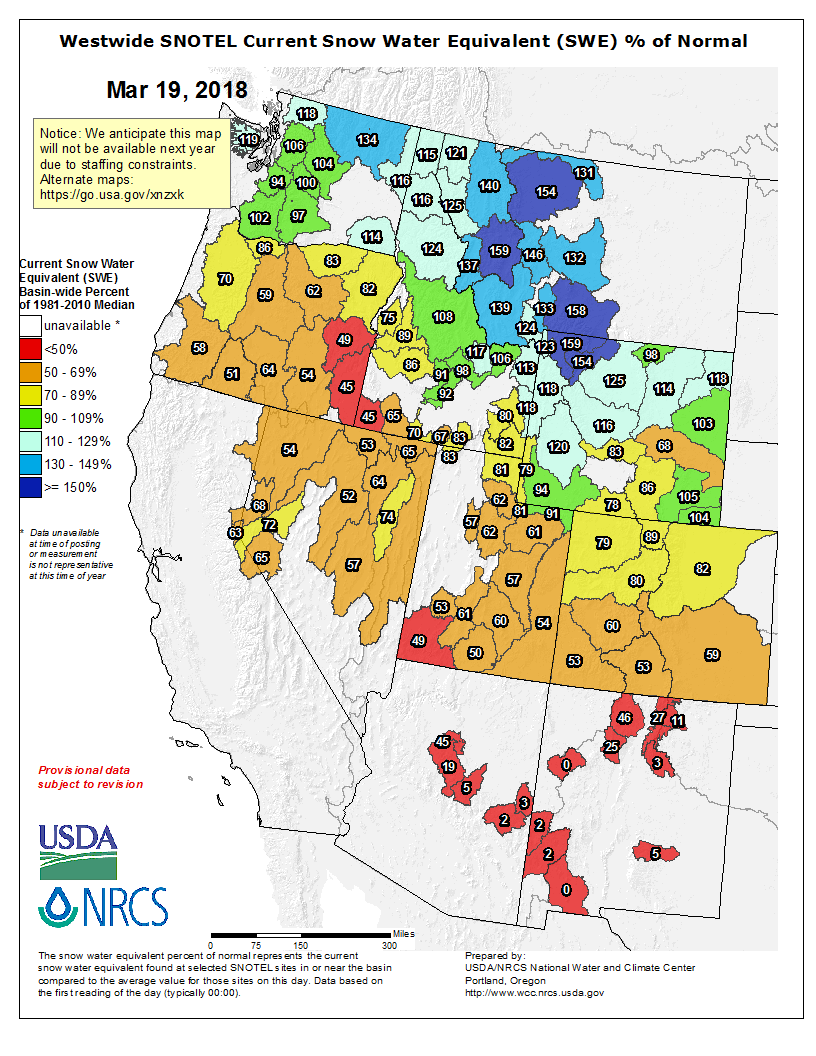


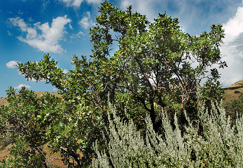


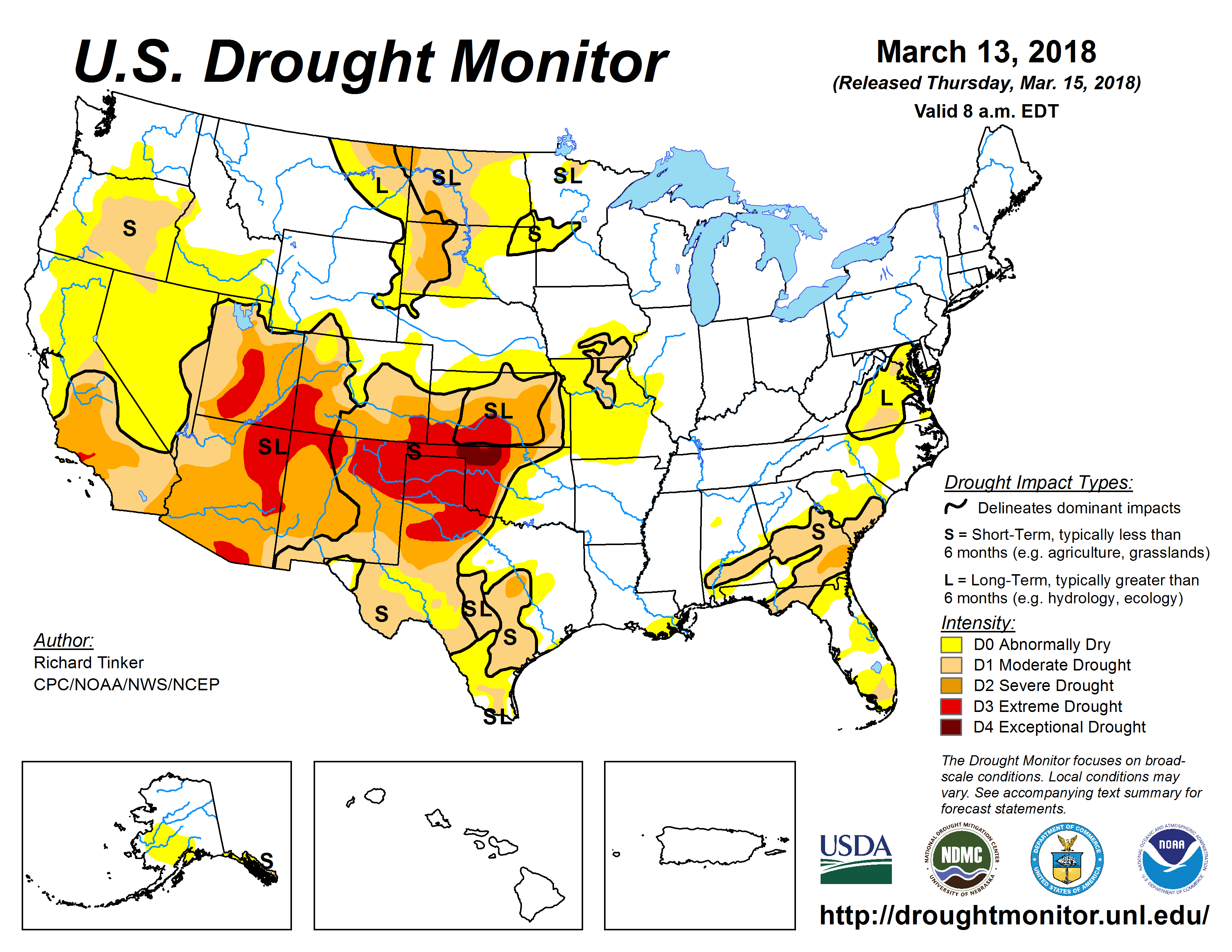
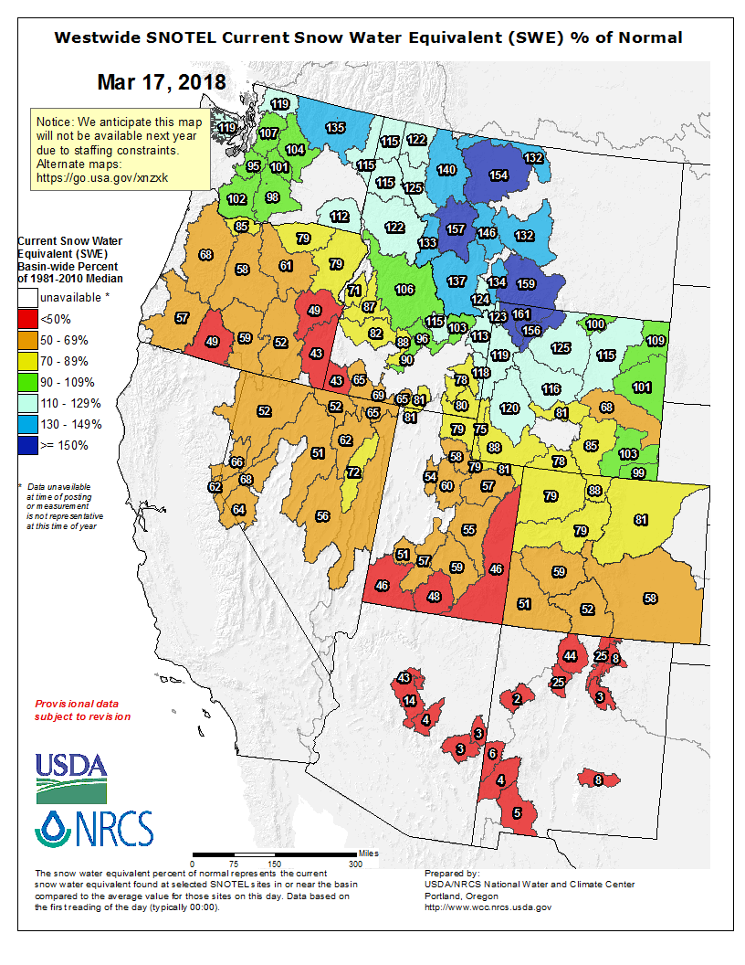


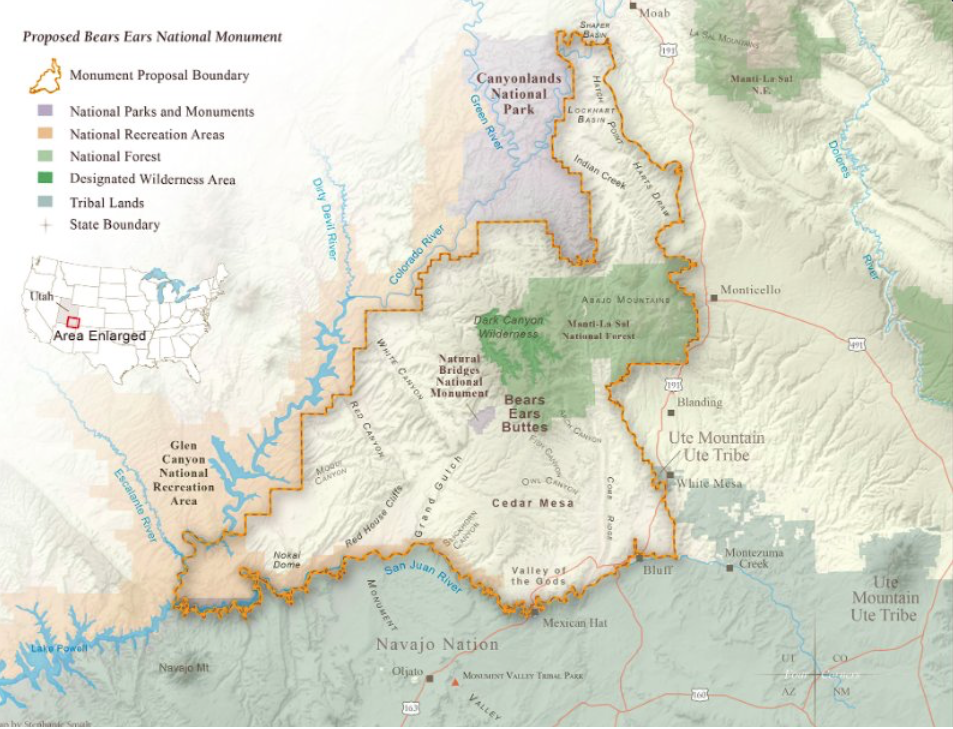


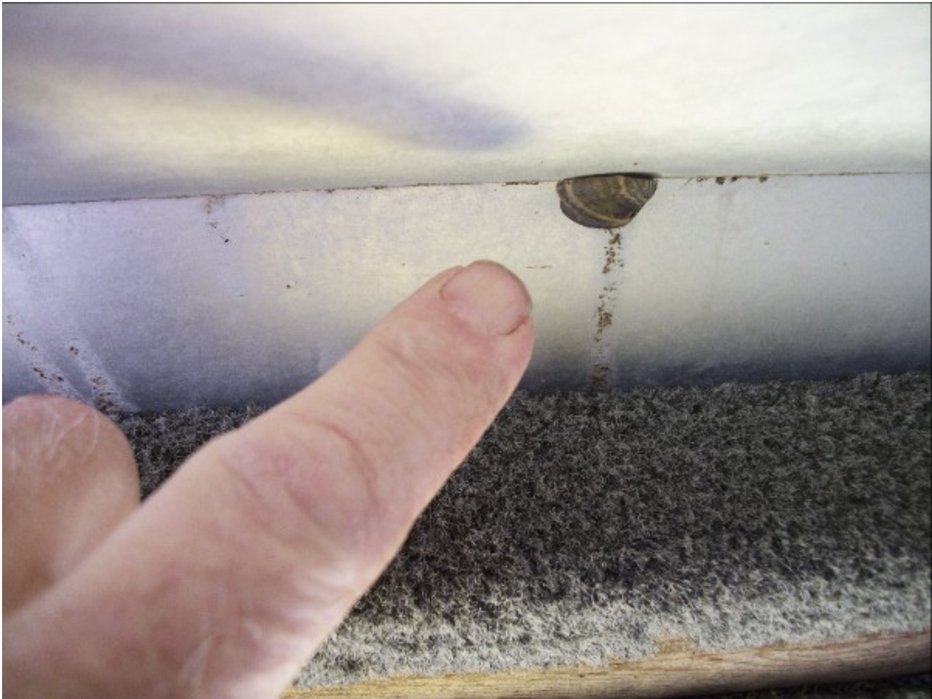
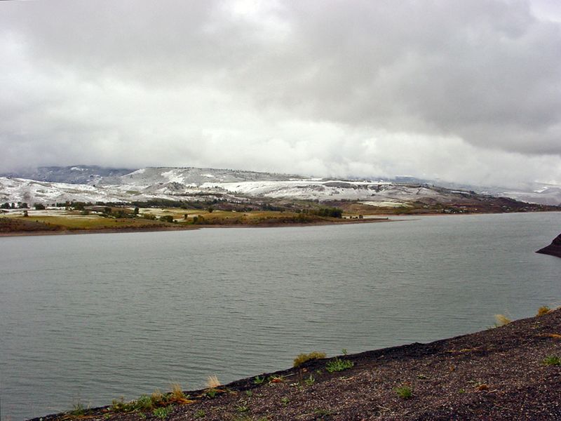


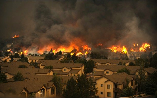
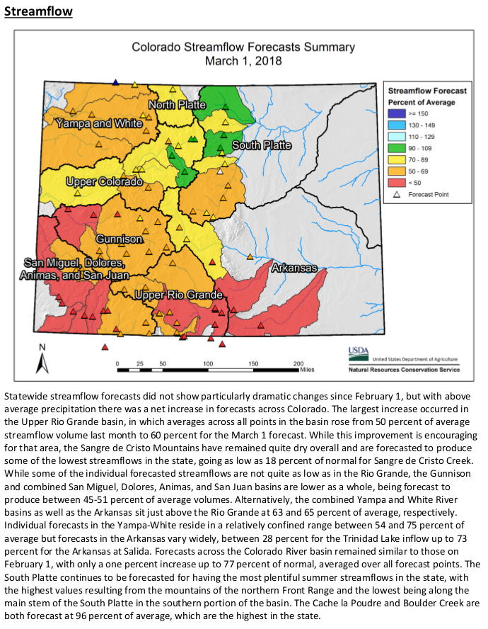


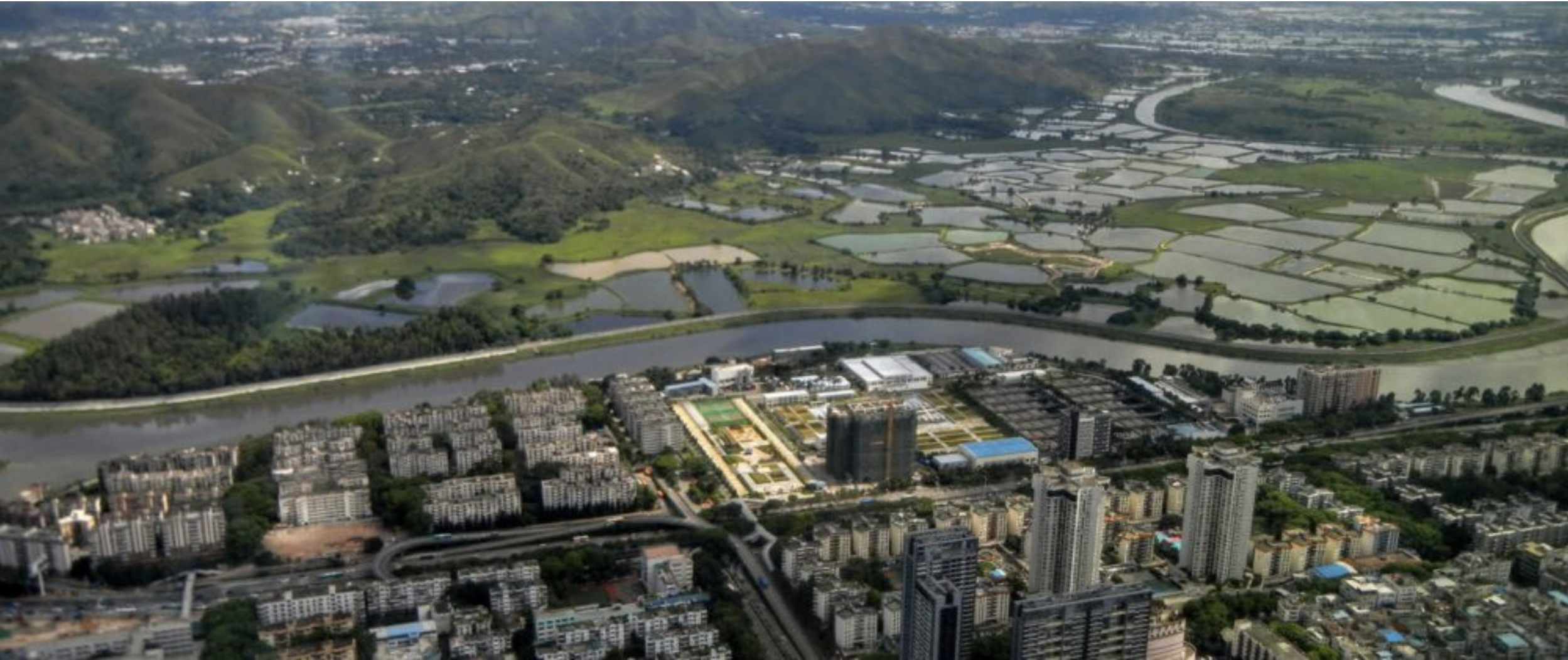
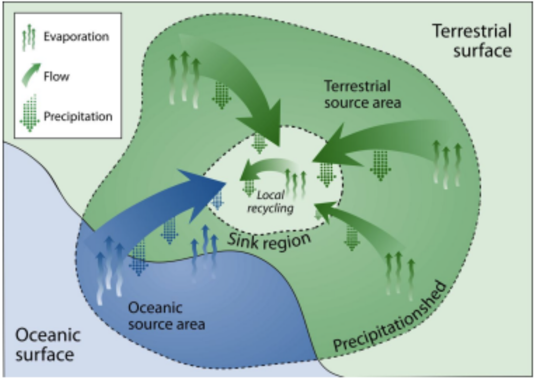


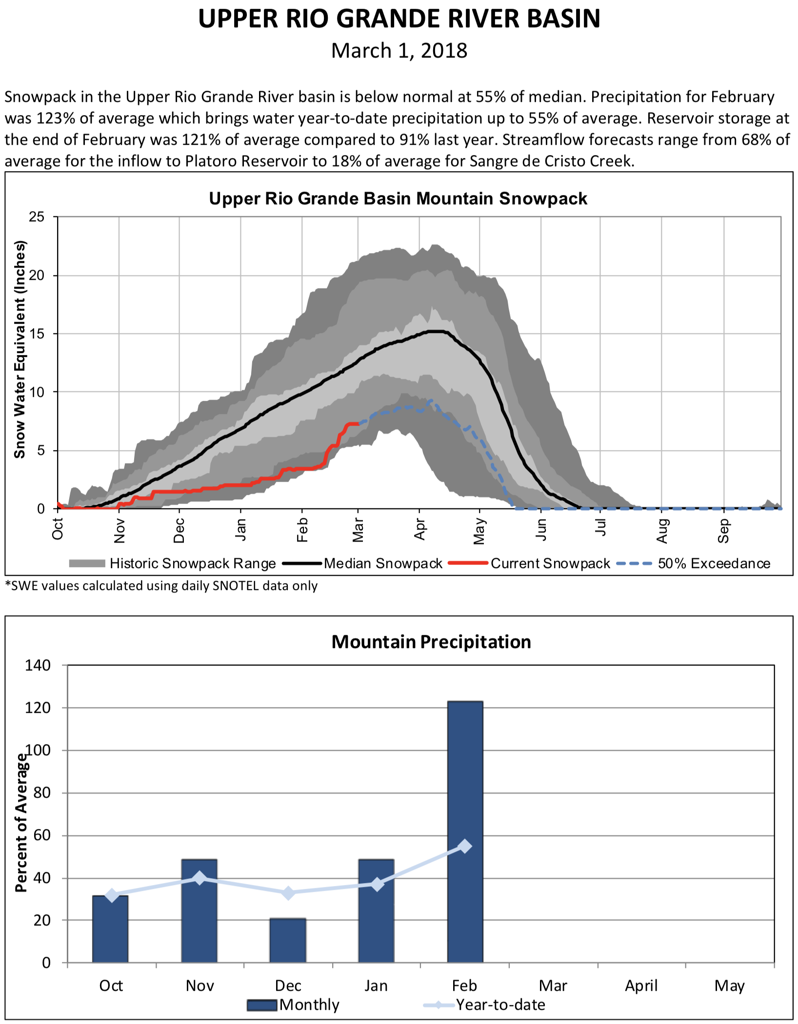


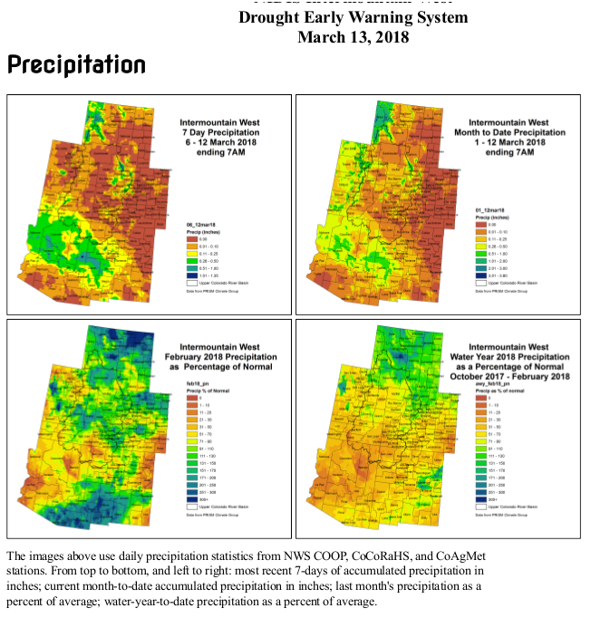

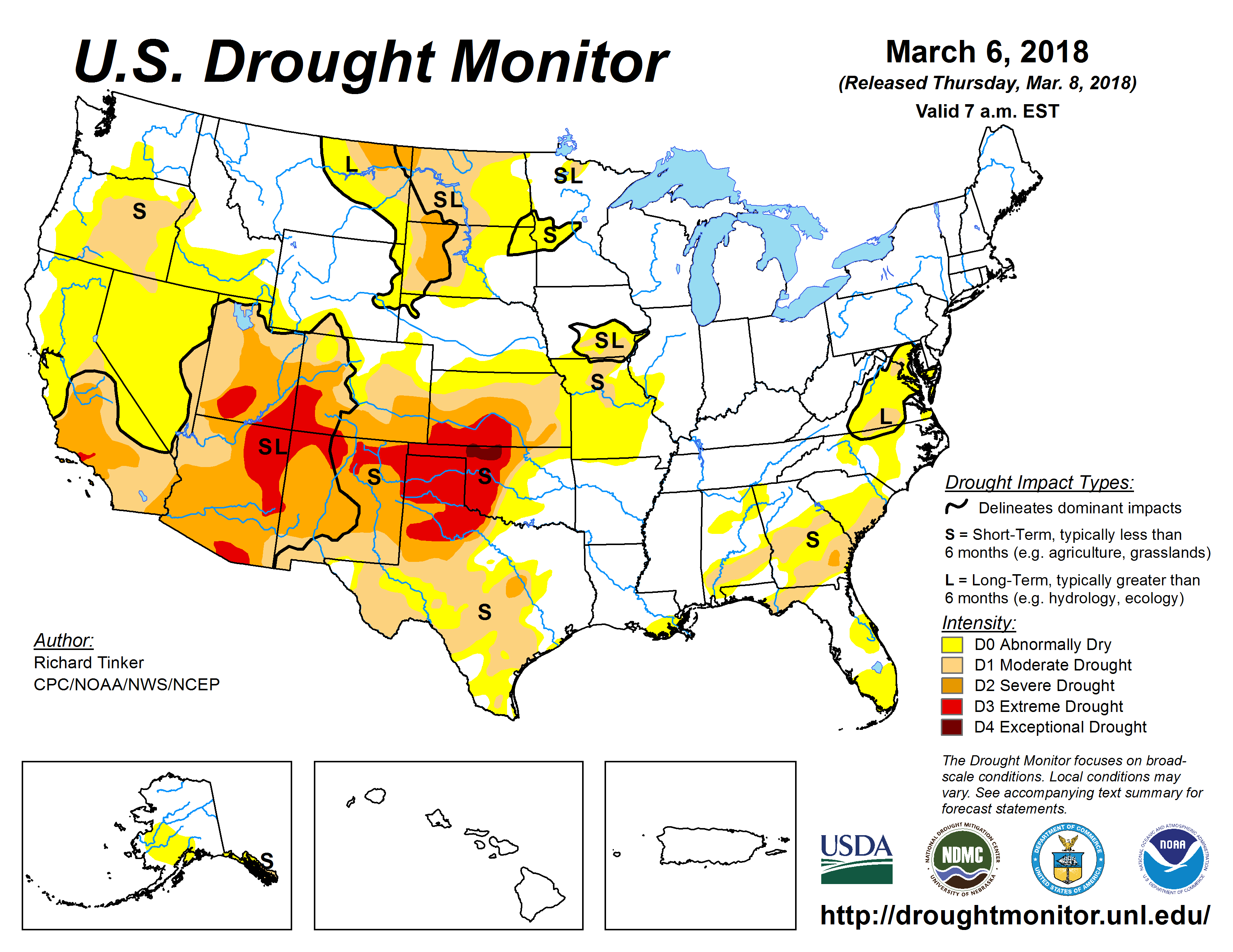
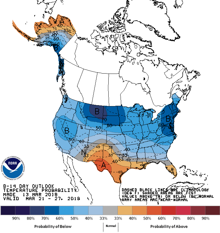
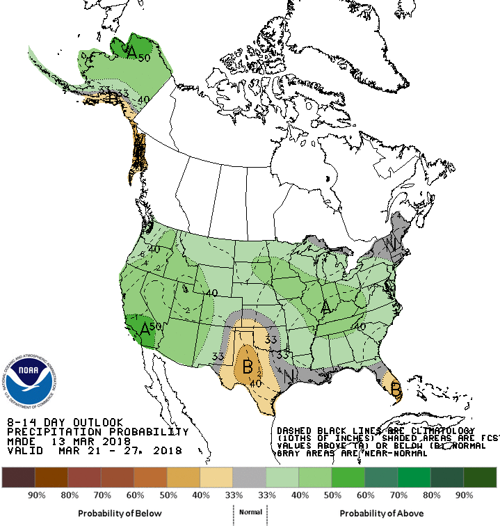


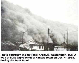


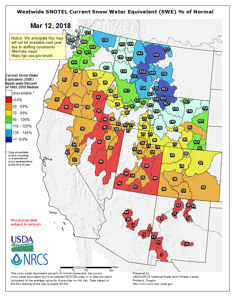
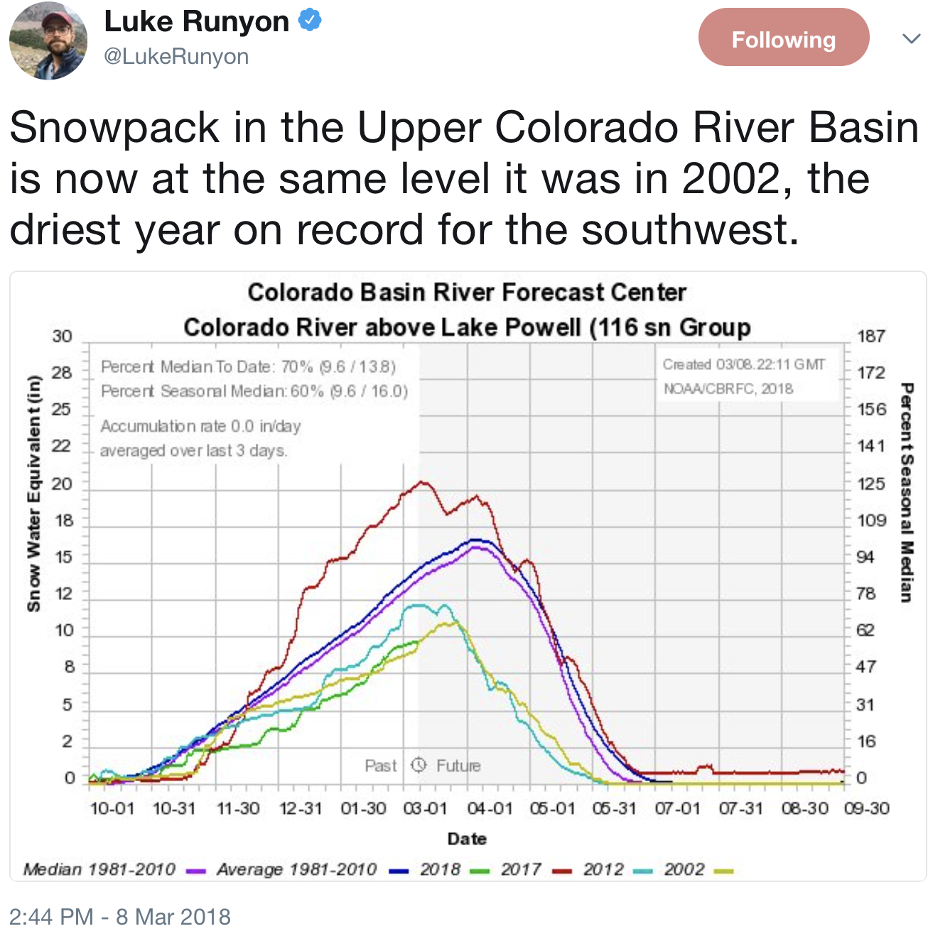
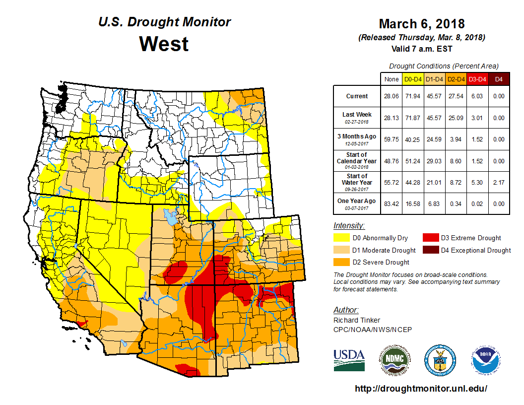


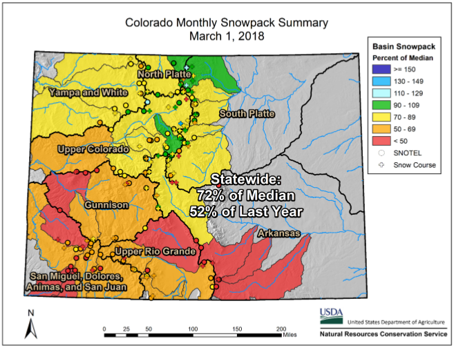
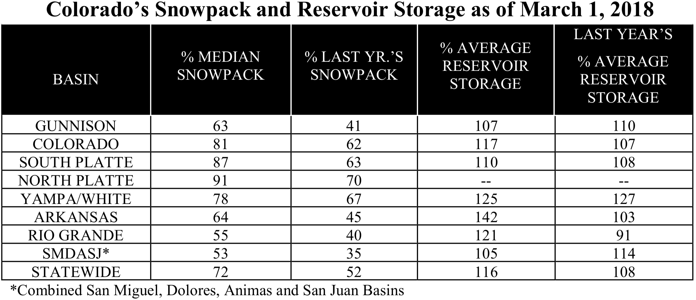