Engineering marvels of 20th century challenged by warming of the 21st
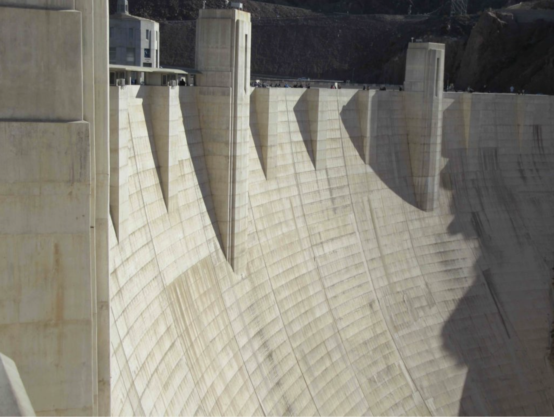
Lake Mead has become a benchmark for worsening water woes of the West. It was something else in 1936, when completion of Hoover Dam was a happy story of triumph, a display of ingenuity and determination for a nation still mired in the Great Depression. At last, the unpredictable Colorado River was tamed! It’s flood waters were finally harnessed to provide electricity but also water for expanding farms and especially for growing cities, Los Angeles first but in time others, too.
It was a time of dam-building in the West, creating reservoirs large and small. Later on the Colorado River, in Glen Canyon, came another dam, creating a water bucket, Powell, almost as big as Mead. To the north, on the Columbia there was Grand Coulee, and in the foothills of the Sierra Nevada and the Colorado Rockies still other dams and reservoirs, canals, tunnels and pipelines, collectively the hydraulic infrastructure that was the ultimate expression of Manifest Destiny.
The dam-building did not subside until the 1970s when, to the dismay of Westerners by then accustomed to a seemingly inexhaustible federal budget for ever more hydraulic manipulation, President Jimmy Carter’s approved what was commonly call a “hit list” of unjustifiable new dams.
By then, virtually every significant river in the West had been plugged or otherwise tapped in ways that eliminated any naturalness to the flows. But the hum an-built infrastructure was premised on the mountain snowpack itself, the major source of water in the West, melting in a somewhat predictable sequence during spring and summer.
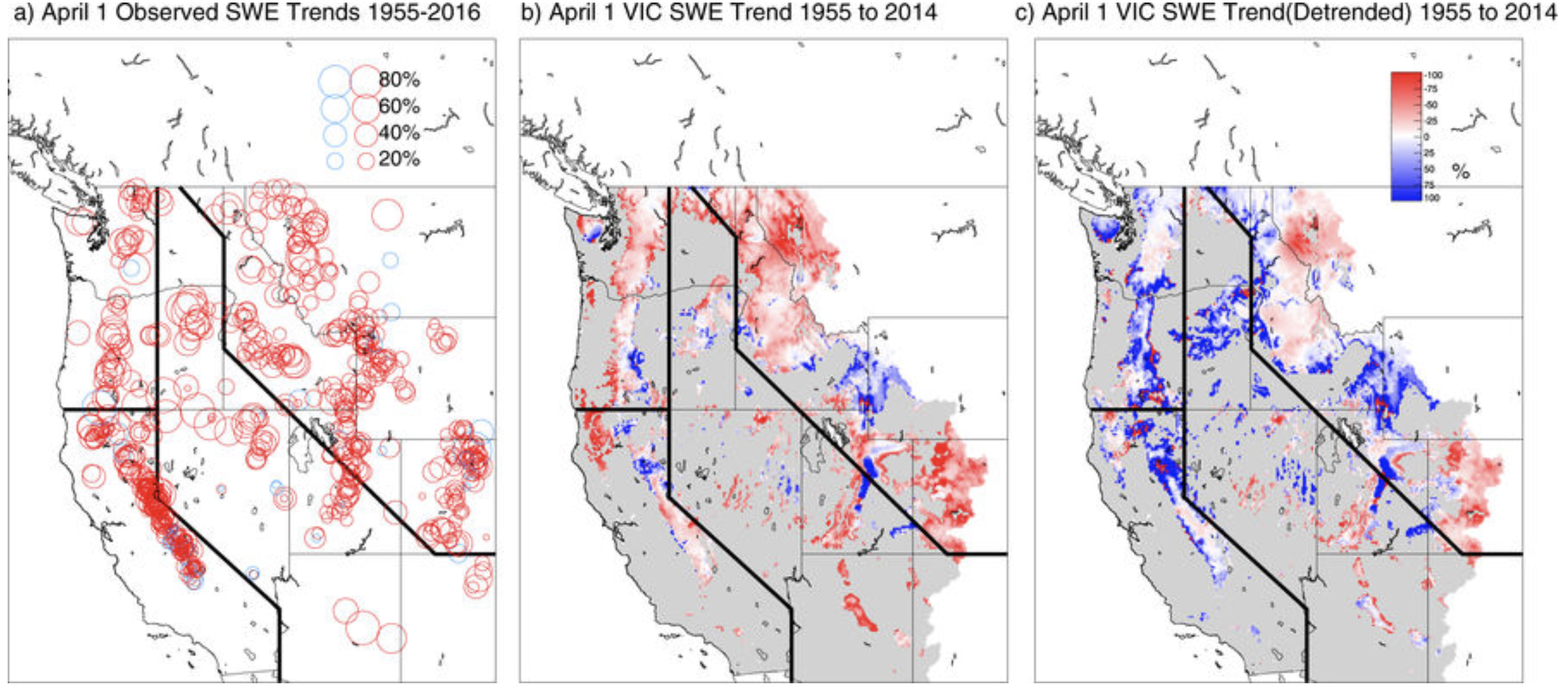
Now this vision is being challenged by warming temperatures and changed hydrology. A new study finds declines at more than 90 percent of snow monitoring sites with long records across the western United States. A third of those declines are significant. The declines, they say, have occurred across all months, states and climates. However, the largest declines have occurred in spring, in the Pacific states, and in places with mild winter climates.
Lake Mead is cited in the report as a reference point. The average April 1 snow-water equivalent since the mid-20th century has declined roughly 15 to 30 percent. Authors of the study say this decline is comparable in the capacity of Lake Mead, the largest man-made reservoir in the West.
“It is a bigger decline than we had expected,” said Philip Mote, lead author of the study and director of the Oregon Climate Change Research Institute at Oregon State University. “In many lower-elevation sites, what used to fall as snow is now rain. Upper elevations have not been affected nearly as much, but most states don’t have that much area at 7,000-plus feet.”
Mote and his colleagues attribute the snowpack decline to warmer temperatures, not a lack of precipitation. But the consequences are still significant. Earlier spring-like weather means less precipitation will linger in the mountain in the form of snow. That, in turn, results in lower volumes of water in rivers and declined reservoir levels during late summer and early fall.
“The solution isn’t in infrastructure. New reservoirs could not be built fast enough to offset the loss of snow storage —and we don’t have a lot of capacity left for that kind of storage,” says Mote in a press release from Oregon State. “It comes down to managing what we have in the best possible ways.”
The study, published last week in NPJ Climate and Atmospheric Science, builds on work that Mote and others reported in 2005 showing that the warming climate was influencing the snowpack and runoff.
Other studies have also painted a picture of a warming climate causing, at least in places, a drying effect. In February 2017, two researchers reported that precipitation in the seven-state Colorado River Basin during 2000-2004 averaged 6.1 percent less than in the 20th century, but flows had declined 19.3 percent.
The study authors, Brad Udall of Colorado State University and Jonathan Overpeck, now of the University of Michigan, pointed to rising temperatures in the 21st century of 1.6 degrees Fahrenheit as a substantial cause of the reduced flows. They predicted further declining water flows in the Colorado River Basin of 35 percent or more during this century.
Udall, a senior climate and water research scientists at CSU’s Colorado Water Institute, says the new study dramatically reinforces what was already broadly understanding.
“I don’t think this fundamentally changes anything. Anybody who has been paying attention already knows this. But it’s always good to get prodded with a sharp stick in the side to make sure you’re not falling asleep,” he said.
Similar to other studies, the new report finds the snowpack in coastal states—California, Oregon and Washington—is most vulnerable to rising temperatures. They receive more precipitation because of the influence of the Pacific Ocean. Also, more of the snow falls at temperatures near freezing. Because the Cascade Mountains, which transect the region, are not as steep as the Rocky Mountains, they have more area that is affected by changes in temperatures.
“When you raise the snow level 300 feet, it covers a much broader swath than it would in the inland states,” Mote said.
Some sites did have increased snowpack. California had the most, but lingering drought during the past decade erased most of the gains. Snowpack declines still dominated. Most other Western states had only one or two sites with increased snowpack.
Mote sees the warming temperatures requiring a fundamental change in water delivery thinking.
“The amount of the water in the snowpack of the Western United States is roughly equivalent to all of the stored water in the largest reservoirs of those states,” he said. “We’ve pretty much spent a century building up those water supplies at the same time the natural supply of snowpack is dwindling.
“On smaller reservoirs, the water supply can be replenished after one bad year. But a reservoir like Lake Mead takes four years of normal flows to fill. It still hasn’t recovered from the drought of the early 2000s.”
Some have even called for the dismantling of some of this water infrastructure, particularly Glen Canyon. The thinking is that both big buckets on the Colorado River will no longer be needed because of the warming, drying climate. Mead can hold 27 million acre-feet of water and Powell 24 million acre-feet, or more than four times the annual flows of the Colorado River. However, the two reservoirs, brimming with water at the turn of the century, have barely been half for the last 15 years.
The new study makes no mention of this argument but does warn that water managers in the West face an “immense challenge” posed by the magnitude of changes caused by continued warming relative to the built storage.
“Patterns of water use that became established (even entrenched) during the climate of the past cannot be changed without intense political effort owing to large cultural, economic, and infrastructure investments in the status quo ante” the report concludes. ‘”Solutions cannot consist solely of future infrastructure: new reservoirs cannot be built fast enough to offset the loss of snow storage, so solutions will have to lie primarily in the linked arenas of water policy (including reservoir operating policies) and demand management.”
Udall makes the same point. He sees new reservoirs offering little help. “It’s like opening up a new bank account when your salary goes down and thinking it will help,” he says. “I just don’t know where the new infrastructure can help much when you’re seeing declining snowpack.”
About Allen Best
Allen Best is a Colorado-based journalist. He publishes a subscription-based e-zine called Mountain Town News, portions of which are published on the website of the same name, and also writes for a variety of newspapers and magazines.
West Drought Monitor March 6, 2018.Westwide SNOTEL March 11, 2018 via the NRCS.
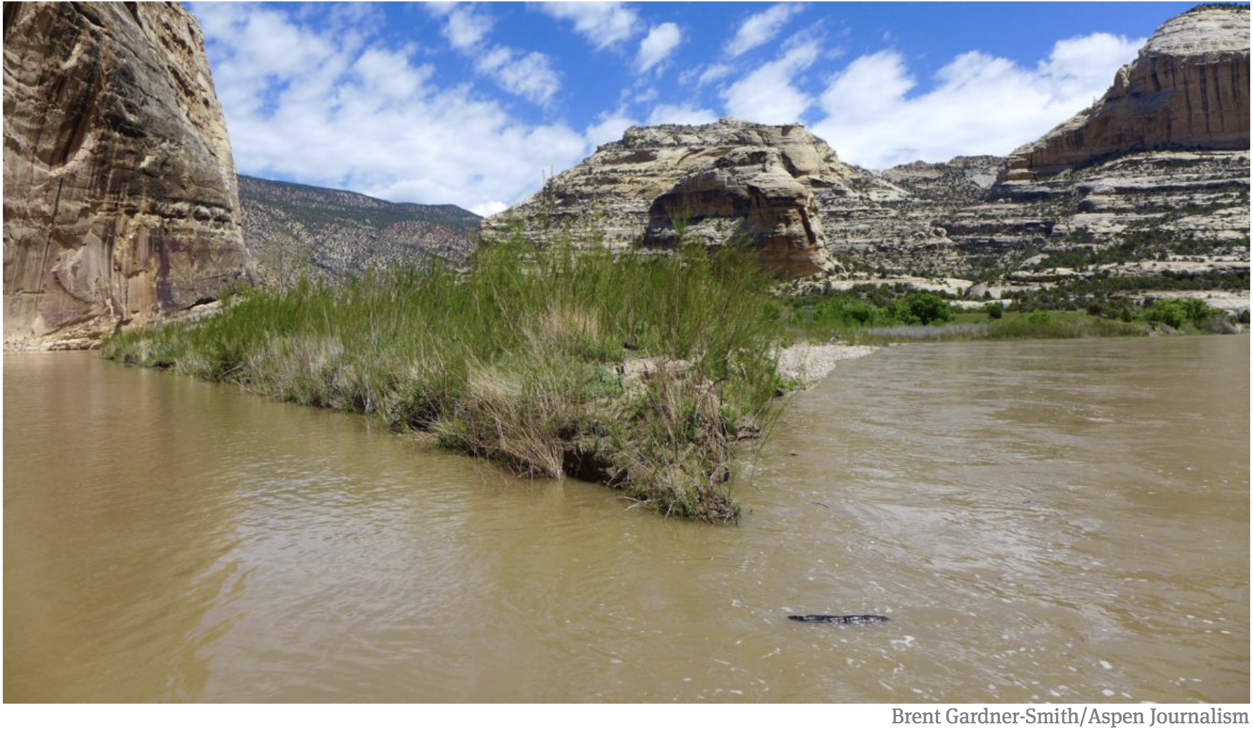
Words are important. In current Colorado River water management, perhaps no word is used (and misused) more than drought. To most people, the word drought contains two concepts. The first is the lack of available water, primarily a function of below normal precipitation, but often exacerbated by management and water‐use practices. Second is the notion that the condition is temporary—a deviation from a norm that is expected to eventually return. Aridity, in contrast, refers to a dryness that is permanent, and is a function of natural (and presumably stable) climatic conditions. While it is fair to say that the Colorado River Basin is in a period of drought (in that recent precipitation has lagged slightly below the long‐term averages), and that much of the basin is arid (or semi‐arid), neither term is adequate to accurately describe emerging conditions in the Colorado River Basin. For that, perhaps the best available term is aridification, which describes a period of transition to an increasingly water scarce environment—an evolving new baseline around which future extreme events (droughts and floods) will occur. Aridification, not drought, is the contingency that should guide the refinement of Colorado River management practices.
The Shifting Baseline
Among the most obvious and alarming symptoms of the changing physical environment is the decline in runoff efficiency—i.e., how much streamflow results from precipitation. Several recent studies have confirmed that, compared to last century, a given level of winter snowpack today results in less river runoff than in the past (Udall and Overpeck, 2017; Woodhouse and Pederson, 2018; Woodhouse et al., 2016; McCabe et al., 2017; and Pitzer, 2017‐18). As an example, compare the 1950s drought and the ongoing 21st century drought (see Figure 1). The former had significantly less precipitation, yet the observed reductions in streamflow are quite similar. Why? In large part, the answer is that the basin has become hotter, which modifies several facets of the hydrologic cycle that lie between precipitation and runoff, including evapotranspiration and sublimation rates, the timing of snowmelt, and soil moisture characteristics. These changes are not primarily the result of reduced precipitation and are not temporary—the typical characteristics of drought—but rather are associated with a warming trend that will continue. Thus, while much of the recent decline in runoff can rightly be characterized as drought, the remaining component is a very different and highly troubling shift in runoff efficiency largely tied to warming—a recipe described as “hot drought.”
Other research contributes further to our understanding of the changing physical environment. Climate models used in recent studies generally project “wetter” conditions (i.e., more precipitation) than preceding efforts (Ayers et al., 2016). However, this provides little reason for optimism. High uncertainties surround these new projections, and increasing temperatures are likely to overwhelm any possible increases in precipitation. Future risks clearly skew dry—possibly with temperature‐induced runoff declines of 35% or more by the end of the century (Udall and Overpeck, 2017; Vano et al., 2014).
These studies also often project a shift in precipitation to the north, with sub‐basins such as the Green becoming more important contributors to streamflow, while the arid conditions of the Lower Basin creep northward through the San Juans and the Colorado River sub‐basin (Dominguez et al., 2012; Niraula et al., 2017). This trend is already evident and shifts runoff away from infrastructure and population centers established under the flawed assumption that historic patterns of climate and runoff were stable.
Also creeping upward, in terms of probabilities, is the regional threat of megadrought. From tree‐rings, we know that such events have happened infrequently in the past, but risks are increasing rapidly (Meko et al., 2007). Measuring the likelihood of future megadroughts in terms of low soil moisture, one major study suggests that the risk of an event lasting 35 years or more later this century is a near certainty (Cook et al., 2015). This finding further reinforces the prospect that ongoing regional desiccation should be viewed a strong and persistent trend rather than a singular, extreme event.
Warming is not the only human‐influenced landscape level change that is affecting runoff levels. One increasingly important phenomenon is “dust on snow”—i.e., the phenomenon that snowfields in the Rockies are more frequently being painted with fine layers of dust that absorb sunlight and thus accelerate snowmelt. Winds now coat the Rockies with five to seven times the dust as seen in the early 19th century, in part due to land disturbances such as grazing that break up soils in the Colorado Plateau and Great Basin. The result, on average, is an earlier (by three‐weeks) start to the snowmelt season, and a projected five percent decrease in runoff (Painter et al., 2010). The impact is most pronounced in high dust years (such as 2009 and 2013), generating early season snowmelt peaks that can overwhelm the ability of managers and infrastructure to cope (Deems et al., 2013; Painter et al., 2017). Earlier and smaller runoffs influence the basin in many undesirable ways, threatening water supplies, fueling a longer fire season, robbing (and warming) late season streamflows, and drying out soils in advance of the next runoff season.
An “Aridification Contingency Plan”
Many productive negotiations and reforms are currently underway in the region, including prominently the “drought contingency plans” (DCPs) under development in both the Lower and Upper Basins. In the short‐term, it is vitally important that those efforts continue to move forward. Longer‐term, the net result of these and future negotiations (such as those regarding the expiration of Interim Guidelines in 2026) must be to address the changing baseline and extreme event probabilities associated with ongoing aridification. Devising an “aridification contingency plan” of this sort is a big and multi‐faceted challenge that may necessitate considering management options currently off‐the‐table in basin negotiations.
Perhaps more importantly, moving forward means abandoning the mindset that current changes to climatic and hydrologic regimes are a temporary phenomenon. We are not likely to ever return to normal conditions; that opportunity has passed (Milly et al, 2008). Rather, there are two possible new normals. First is a continuation (and likely acceleration) of the current drying trend and the accompanying increase in variability, an outcome largely “baked into” the system by existing atmospheric greenhouse gas concentrations. A second, and better, new normal would be to establish regional hydrologic conditions at a steady new level—a step change—that results from the stabilization of atmospheric greenhouse gas concentrations at some new equilibrium. Achieving this second outcome will require many actions taken across the globe, and in sectors beyond water management. Nonetheless, the Colorado River management community can still be a leader in promoting and contributing to such actions. There is much to gain in the basin by leading on these larger issues, as well as by exploring local opportunities—such as dust suppression—to slow or halt ongoing environmental changes. It is time for water managers to both adapt for the profound changes the future holds and to advocate within the political sphere for a reduction in greenhouse gas emissions. A very modest starting point is to admit words such as drought and normal no longer serve us well, as we are no longer in a waiting game; we are now in a period that demands continued, decisive action on many fronts.
LITERATURE CITED
Ayers, J., D.L. Ficklin, I.T. Stewart, and M. Strunk. 2016. “Comparison of CMIP3 and CMIP5 projected hydrologic conditions over the Upper Colorado River Basin.” International Journal of Climatology 36.11: 3807‐3818. http://onlinelibrary.wiley.com/doi/10.1002/joc.4594/full.
Cook, B., T.R. Ault, and J.E. Smerdon. 2015. “Unprecedented 21st century drought risk in the American Southwest and Central Plains.” Science Advances 1.1: e1400082. http://advances.sciencemag.org/content/1/1/e1400082.full.
Deems, J.S., T.H. Painter, J.J. Barsugli, J. Belnap, and B. Udall. 2013. “Combined impacts of current and future dust deposition and regional warming on Colorado River Basin snow dynamics and hydrology.” Hydrology and Earth System Sciences. 10(5), 6237–6275. https://www.hydrol‐earth‐syst‐sci.net/17/4401/2013/hess‐17‐4401‐2013.pdf.
Dominguez, F., E. Rivera, D.P. Lettenmaier, and C.L. Castro. 2012. “Changes in winter precipitation extremes for the western United States under a warmer climate as simulated by regional climate models.” Geophysical Research Letters, 39, L05803. https://doi.org/10.1029/2011GL050762.
McCabe, G.J., D.M. Wolock, G.T. Pederson, C.A. Woodhouse, and S. McAfee. 2017. “Evidence that Recent Warming is Reducing Upper Colorado River Flows.” Earth Interactions, 21(10):2. https://journals.ametsoc.org/doi/pdf/10.1175/EI‐D‐17‐0007.1
Meko, D. M., C.A. Woodhouse, C.A. Baisan, T. Knight, J.J. Lukas, M.K. Hughes, and M.W. Salzer. 2007. “Medieval drought in the upper Colorado River basin.” Geophysical Research Letters, 34, L10705, https://doi.org/10.1029/2007GL029988.
Milly, P.C.D., J. Betancourt, M. Falkenmark, R.M. Hirsch, Z.W. Kundzewicz, D.P. Lettenmaier, and R.J. Stouffer. 2008. “Stationarity is dead: Whither water management?” Science, 319, 573–574. http://science.sciencemag.org/content/319/5863/573.full.
Niraula, R., T. Meixner, F. Dominguez, N. Bhattarai, M. Rodell, H. Ajami, D. Gochis, and C. Castro. 2017. “How Might Recharge Change Under Projected Climate Change in the Western U.S.?” Geophysical Research Letters, 44, 10407‐ 10,418, https://doi.org/10.1002/2017GL075421.
Painter, T.H., J.S. Deems, J. Belnap, A.F. Hamlet, C.C. Landry, and B. Udall. 2010. “Response of Colorado River runoff to dust radiative forcing in snow.” Proceedings of the National Academy of Sciences (Early Edition), http://www.pnas.org/cgi/doi/10.1073/pnas.0913139107.
Painter, T.H., S.M. Skiles, J.S. Deems, W.T. Brandt, and J. Dozier . 2017. “Variation in the Rising Limb of Colorado River Snowmelt Runoff Hydrograph Controlled by Dust Radiative Forcing in Snow,” Geophysical Research Letters 44. http://onlinelibrary.wiley.com/doi/10.1002/2017GL075826/full.
Pitzer, G. “A Warmer Future and Increased Risk” The Water Education Foundation: The Water Report 2017‐2018 Winter. http://www.watereducation.org/sites/main/files/file‐attachments/19677_wef_12pg_website.pdf.
Udall, B., and J. Overpeck. 2017. “The twenty‐first century Colorado River hot drought and implications for the future.” Water Resources Research 53, 2404‐2418, https://doi.org/10.1002/2016WR019638.
Vano J.A., B. Udall, D.R. Cayan, J.T. Overpeck, L.D. Brekke, T. Das, H.C. Hartmann, H.G. Hidalgo, M. Hoerling, G.J. McCabe, K. Morino, R.S. Webb, K. Werner, and D.P. Lettenmaier. 2014. “Understanding uncertainties in future Colorado River streamflow.” Bulletin of the American Meteorological Society, 95:59–78; https://journals.ametsoc.org/doi/abs/10.1175/BAMS‐D‐12‐00228.1.
Woodhouse, C.A., G.T. Pederson, K. Morino, S.A. McAfee, and G.J. McCabe. 2016. “Increasing influence of air temperature on upper Colorado River streamflow.” Geophysical Research Letters, 43, 2174–2181. https://doi.org/10.1002/2015GL067613
Woodhouse, C. A., and G.T. Pederson. 2018. “Investigating runoff efficiency in upper Colorado river streamflow over past centuries.” Water Resources Research, 54. https://doi.org/10.1002/2017WR021663.
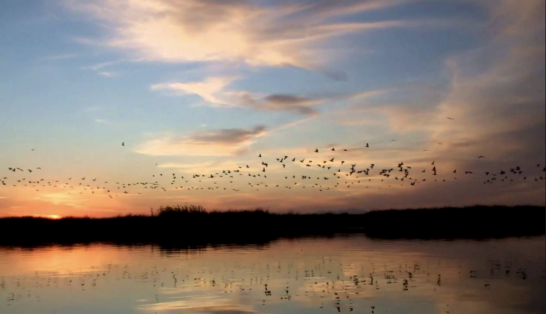
Every March, thousands of Sandhill cranes stop in #GreatSandDunes National Park & Preserve on their way to their northern breeding grounds. The fields and wetlands of #Colorado’s San Luis Valley provide excellent habitat for these majestic #birds. With the dunes and mountains nearby, they dance and call to each other. It’s one of nature’s great spectacles. Photo @greatsanddunesnps by #NationalPark Service.
Sandhill Cranes
Sandhill Cranes in flight via Colorado Parks and Wildlife
Sandhill Crane in flight via DanonArtFrames.com
Sandhill Crane
Sandhill Cranes
Posting may be intermittent for a while. I’m heading south to celebrate my birth anniversary. The National Park Service says of this annual migration, “It’s one of nature’s great spectacles.”
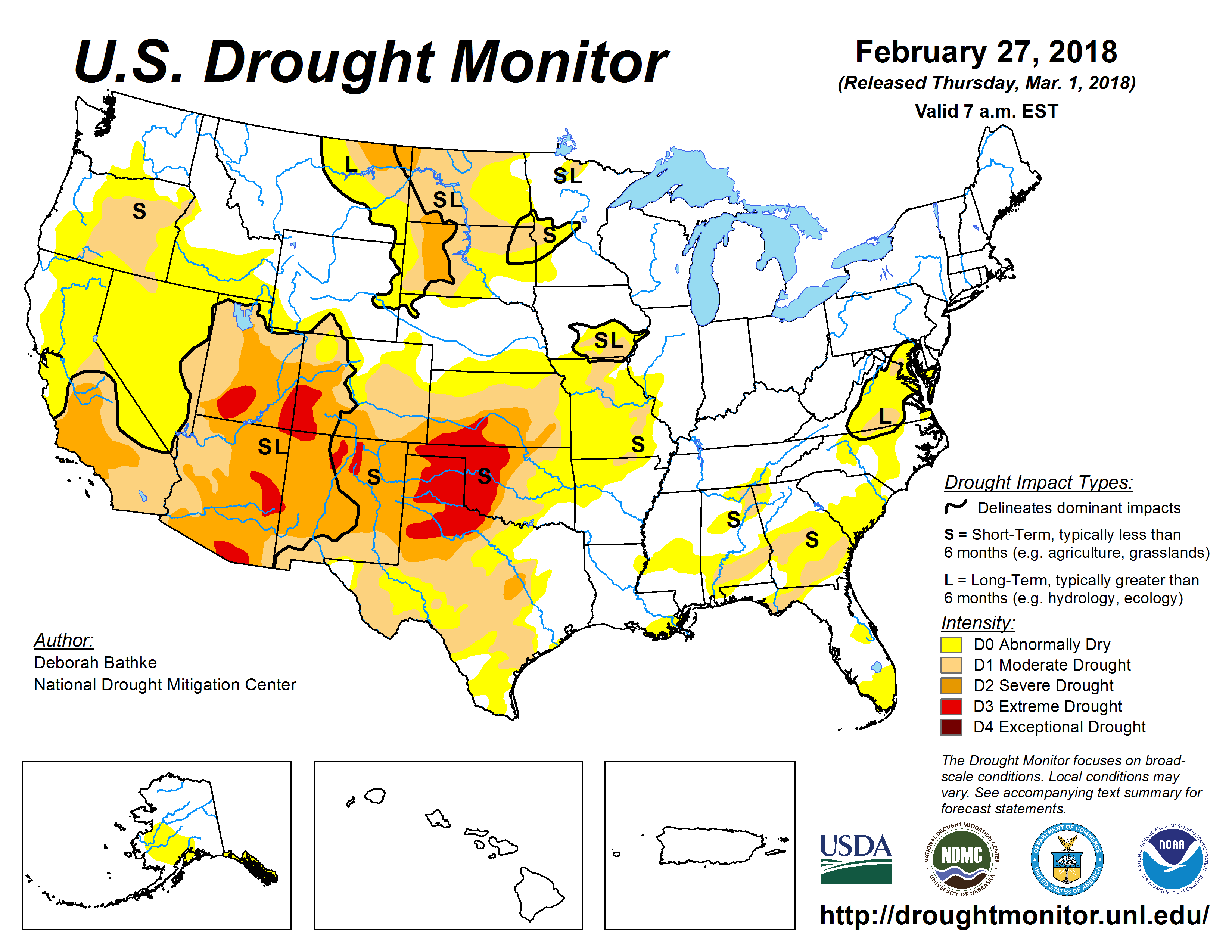
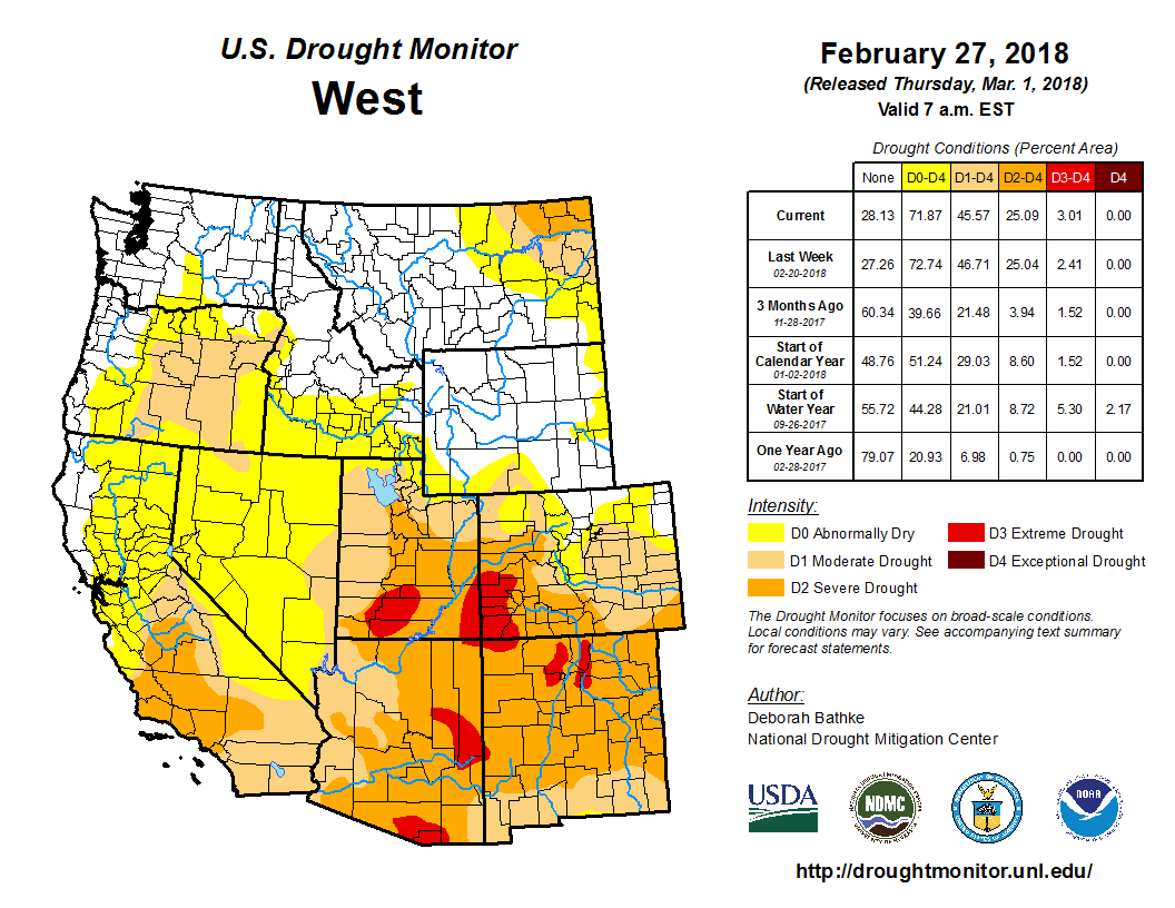
Click on a thumbnail graphic to view a gallery of drought data from the US Drought Monitor.
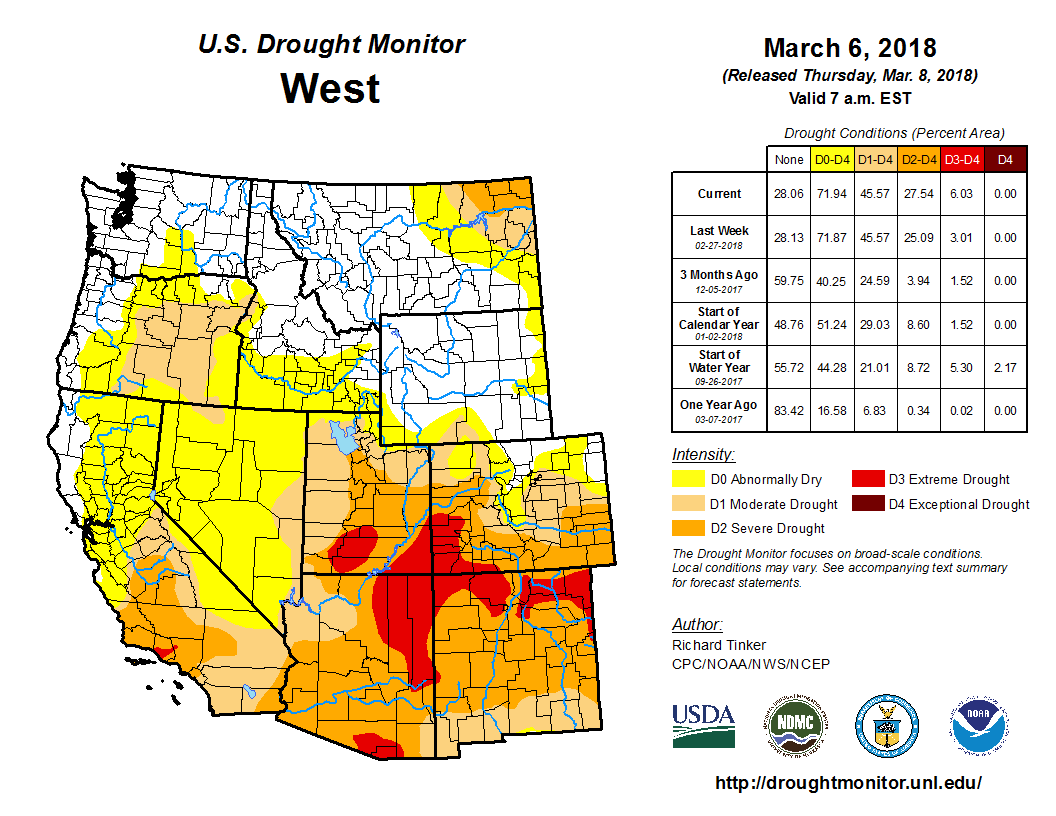
US Drought Monitor March 6, 2018.
West Drought Monitor March 6, 2018.
Colorado Drought Monitor March 6, 2018.
Click here to go to the US Drought Monitor website. Here’s an excerpt:
Summary
Moderate to heavy precipitation evaded most areas of dryness and drought this week, falling on the lower Northeast, a swath from northeastern Texas eastward through the upper Southeast and Tennessee Valley, the Sierra Nevada, and parts of the West Coast. In areas of existing dryness and drought, precipitation exceeded 1.5 inches only in southeastern Tennessee and adjacent areas, the southeastern tier of the dry area in Arkansas, the Sierra Nevada, and portions of southwestern California. Windstorms were almost as noteworthy as precipitation patterns this past week. The mid-Atlantic and Northeast were buffeted by gusts frequently reaching 55-70 mph, and briefly climbing to over 90 mph in southern New England, during the first couple days of the month. Toward the end of the period, strong winds and similar gusts were observed across much of Kansas and the adjacent High Plains, spinning up dust storms in a few areas.
South
Moderate rains ended D0 conditions in central Mississippi and adjacent Louisiana, and across northwestern Arkansas. Farther west, further improvements were made in the eastern half of Oklahoma as a result of the heavy February precipitation. Small adjustments were made across southern and central Texas, but continued dryness with periods of strong winds and low humidity led to broad deterioration from the Texas Panhandle and northeastern New Mexico northeastward into the central Plains. This resulted in broad D3 expansion across western sections of the Texas and Oklahoma Panhandles, and much of northeastern New Mexico. These areas received less than 10 percent of normal precipitation during the last 90 days and generally under half of normal precipitation since late autumn. Unirrigated winter wheat in the Texas Panhandle and adjoining areas is almost a total loss…
High Plains
Southern parts of the Plains (above central Texas) experienced another week with little or no precipitation, prompting large-scale deterioration across the Texas and Oklahoma Panhandles, northeastern New Mexico, and central and western Kansas. This results in a broad area of D3 as noted in the South region write-up, with D1 and D2 areas also expanding northward through parts of central Kansas.and east-central Colorado.
In sharp contrast, heavy and generally wet snow covered much of the Dakotas and adjacent areas, with near-blizzard conditions observed at times during the storm. Up to a foot and a half of snow was measured in parts of the central Dakotas. This let to removal of drought from the east-central Dakotas and adjacent Minnesota, and abnormal dryness retracted out of east-central South Dakota. Much smaller areas of improvement were observed farther west, and in part of western South Dakota that missed most of the snowstorm, some slight D1 and D2 expansion was introduced. Conditions were generally unchanged in Montana, though D0 was pulled out of a small area in the interior southeast of the state.
West
A storm system pushed in from the Pacific Ocean, bringing heavy snow to most of the Sierra Nevada. The boost in snowpack was beneficial, but seasonal totals remained well below normal, and there was no marked change in the drought conditions that have covered the mountain range for several months. Farther south, Light to moderate precipitation kept most of southwestern California from deteriorating, but a small area of D3 was introduced in part of Ventura and adjacent Los Angeles Counties where less than 0.25 inch of precipitation fell. Livestock and rangeland have been severely stressed by the drought in this area.
Reports of deteriorating livestock and rangeland conditions led to broad deterioration near the California/Arizona border and in a broad swath across the middle of the Four Corners region. D3 now covers a nearly continuous stretch from northeastern Arizona and southeastern Utah eastward into central Kansas and Oklahoma. The Navajo Nation declared a drought emergency due to poor rangeland and reduced water stores…
Looking Ahead
The next 5 days (March 8 – 12, 2018) should bring moderate to heavy precipitation (locally over 2 inches) to northern sections of Alabama and Georgia. Moderate amounts (0.5 to 1.5 inches) are forecast for North Carolina, the mid-Atlantic, and southern Missouri. The other areas of dryness and drought across the contiguous states will only see a few tenths of an inch, if any. Somewhat above-normal temperatures (by 3 to 9 degrees) are expected in the West, the Four Corners States. Farther east, near- to slightly below normal temperatures are forecast in the areas of dryness and drought from the Great Plains and Lower Mississippi Valley to the East Coast.
During the 6-10 day period (March 13 – 17), the odds favor drier than normal weather in most of the Great Plains and through most of the country from the Mississippi River eastward. Below-normal precipitation is also favored in southeastern Alaska. Meanwhile, enhanced chances for above-normal precipitation cover southern Texas, the northern Plains, southwestern Alaska, and from the Rockies westward to the Pacific Coast.
Judges say EPA followed rules when including mining sites in cleanup area
The U.S. Court of Appeals D.C. Circuit issued the decision Tuesday to deny Sunnyside’s petition, which was filed by the mining company – a “potentially responsible party” in the Superfund cleanup – in December 2016.
Sunnyside had argued that of the 48 mining sites in the upper Animas River watershed the EPA included in the “Bonita Peak Mining District Superfund” site, 29 had not been properly evaluated and should be removed.
Sunnyside owns two of the 29 sites mentioned, including the Sunnyside Mine and the Mayflower tailings.
“We have no objections to there being a Superfund listing,” Sunnyside spokesman Larry Perino previously said. “The petition is only challenging the unlawful listing of sites that were not assessed at all under the EPA’s own Hazard Ranking System.”
Perino did not immediately respond to requests for comment Tuesday afternoon.
However, the U.S. Court of Appeals D.C. Circuit decision says the EPA did act lawfully and within its own protocols in the Superfund process.
In determining whether the mining district around Silverton qualified for a Superfund listing, the EPA scored 19 pollution sources under the agency’s Hazard Ranking System.
Each of the sources received a high enough score that indicated pollution was bad enough to be eligible for a Superfund listing. As a result, EPA proposed the entire mining district, scored and unscored sources, should be listed.
The Bonita Peak Mining District Superfund site was declared in September 2016.
Months later, Sunnyside argued the EPA was wrong to create a Superfund site that had unscored sources, claiming the EPA must score each contributing source of contamination before adding it to the broader Bonita Peak site.
But the court said text of the HRS process “alone is enough to refute this assertion,” which says a Superfund “may include multiple sources and may include the area between sources.”
“The BPMD is a site (comprised) of the 19 scored sources and the areas ‘between’ them, as the HRS explicitly permits,” the court said. “Sunnyside’s mine falls into the category of an ‘area between sources’ and therefore did not need to be scored.”
The court said: “Sunnyside’s real concern became apparent at oral argument. It claims its mine has been fully remediated and had no part in the present pollution of the site, but it may nevertheless be required to pay for some or all of the cleanup.”
Sunnyside Gold is considered the largest “potentially responsible party” in the district – a term the EPA uses for entities it considers financially on the hook for cleanup.
The worry also is widespread, considering the reach of this winter’s drought is even worse than in 2012, a year that brought the worst drought in the U.S. since the Dust Bowl and cost farmers, ranchers and governments an estimated $30 billion, according to the federal National Centers for Environmental Information.
If things don’t get better, it’ll show in producers’ pocketbooks and on the taxpayers’ dime — a difficult thing to swallow considering the U.S. Department of Agriculture expects farmers’ incomes to be at a 12-year low even if crop yields stay high.
However, it’s only February, which is one of the driest months on the calendar. And, outside of some winter wheat, the lack of moisture won’t impact many crops. There’s still time for spring rains to rehydrate the region.
“If this was July, we’d be hitting the panic button,” according to Illinois State Climatologist Jim Angel. “But in the wintertime, it’s always kind of a little odd because droughts develop slowly and you know there’s not much going on out there.”
A few larger rainfall events could bring areas back to normal by the time planting season comes around. That’s what happened in 2013, when the 2012 drought lingered into the new year causing conditions even drier than now…
The West is another story: “California, Arizona, New Mexico, that area is getting drier over time,” he says. “And that’s some of the expectation of how it will move in the future; that we’ll continue to get wetter and they’ll continue to get drier.”
Dry country
In the southeast corner of Colorado, Gary Melcher says there’s been at least 10 years of winter drought out of the last 13. The region got rain throughout much of 2017, and Melcher, who lives in Holly, says they’ll depend on what’s left over.
“We were blessed last year with some moisture so that’s given us the ability to hold on and wait for a little bit of this spring moisture hopefully,” he says.
But it’s not just crops. Dustin Stein has a cattle ranch in Mancos, located in southwest Colorado. He’s a relatively young farmer, in his 30s, and started out in the midst of the 2012 drought.
He says in the roughest, driest years, farmers have to make sacrifices because there’s not enough grass growing in the fields.
“In a drought year, you’re forced to sell off your asset [cows and heifers] in a way that helps you keep your other assets alive,” Stein says, adding that it doesn’t just affect ranchers that year, but down the line in terms of herd numbers and profits.
Farmers can get protection from these extreme climate events through crop insurance. In years without such events, farmers and private insurance companies cover much of the costs through premiums. But when disastrous storms or a drought strike, the federal government is stuck with most of the bill. In 2012, for example, there were $17 billion in crop insurance payouts, and the government covered $12 billion. That was an unusually high payout (more than twice the cost of recent years), but an illustration of just how much a major climate event affects financials.
There’s also a need to adapt, Stein says, though he knows young farmers may not have the experience to understand how their fields stand up to prolonged drought.
“So we’re constructing a barley fodder house right now to grow hydroponically grown barley,” he says. “And so that will allow me to not have to sell any animals and be able to keep them healthy and alive through the summer, even though I can’t grow any grass on the acreage that we own or lease.”
But sometimes even adaptations can’t stand up Mother Nature. Stein says he’ll be hoping for the best. If he doesn’t see the grass coming back to life in spring, though, he knows the drought is starting to impact his region.
Angel says his agency will likely know whether the Midwest is in for a bad drought by late spring.
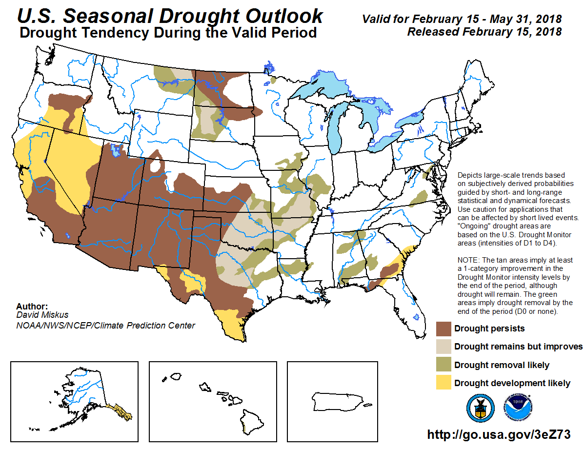
Three month drought outlook through May 31, 2018 via the CPC.
“On this map, orange indicates D2 or serve drought and the bad news, we are even starting to see some in the red which means extreme areas,” said Ken Water of the National Weather Service in Phoenix.
Arizona has had an incredibly dry winter. Conditions show the drought is back.
“If we go back and look at the last six months or so we’ll see we are way, way below average,” said Waters.
Figures show we’re 30 percent below normal precipitation and it’s not just our rainfall.
“Snowpack across Arizona has been extremely low this year, too,” said Waters…
According to the Arizona Department of Water Resources, our meager snowfall has ranked the past year right up there with our driest years 2000 and 2006.
“Really bad news is the bulls-eye is kinda concentrated right over Arizona,” said Waters.
sWaters is referring to the current prediction map for Arizona for the month of March. It shows a brown area that covers all of Arizona and parts of California, Nevada, Utah and New Mexico, showing these areas to have a higher chance of below average precipitation.
And our current weather pattern predictions beyond March are showing the worst possible scenarios.
“All signals are pretty much pointing to a very dry condition right up until monsoon,” said Waters.
And history shows there is a correlation between drought and powerful dust storms…
When we look at weather patterns for winter of 2018, we look for El Niño and La Niña. Right now, it looks neutral but is leaning towards La Niña, which would mean another dry winter for Arizona.
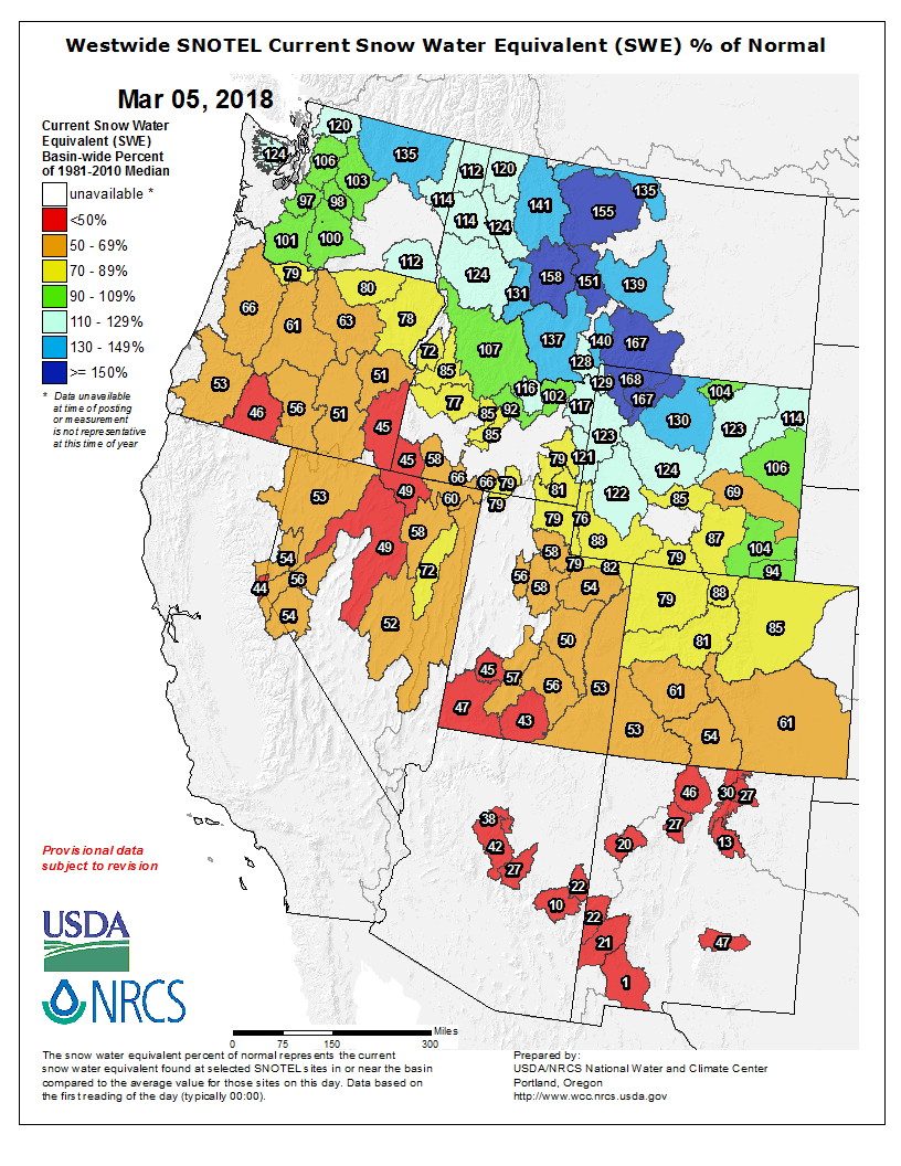
Westwide SNOTEL basin-filled map March 5, 2018 via the NRCS.
Steamboat Ski Area in February received close to average snowfall.
The ski area measured 59.75 inches of snow at mid-mountain over the month. Over the past 20 years, the ski area, on average, has received 66.85 inches of snow during February.
The most notable day this past month was Feb. 16 when 9.5 inches was measured at 5 a.m. for the previous 24-hour period.
So far during the 2017-18 season, 191.5 inches of snow has fallen at mid-mountain.
Looking ahead to March, the ski area traditionally receives an average of 48.39 inches of snow during the month.
Skiers will be hoping for better conditions than March 2017 when a mere 11.25 inches of snow fell at mid-mountain during the entire month.
At nearby Buffalo Mountain, the automated Tower weather station at 10,500 feet elevation was measuring 86 inches of settled snow Wednesday with the equivalent of 27.1 inches of water.
The snow water equivalent at Tower stood at 76 percent of average while the entire Yampa and White River basins were at 81 percent of average.
The Rabbit Ears weather station was reporting snow water equivalent that was 70 percent of average.
River basins in southern Colorado were reporting snow water equivalents between 55 and 63 percent of average.
Nick Barlow with the Colorado Avalanche Information wrote that with the snowiest months already past, it was looking unlikely that snow water equivalents would recover to average levels.
“Unfortunately, low snowpack levels have consequences well beyond winter recreation,” Barlow wrote. “State commerce and tourism can suffer significantly during and directly following a dry winter. We also depend on a healthy snowpack for water supply and agriculture during the drier months.”
A dry winter can also lead to increased wildfire danger.
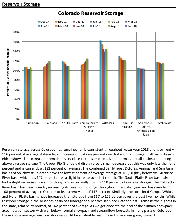
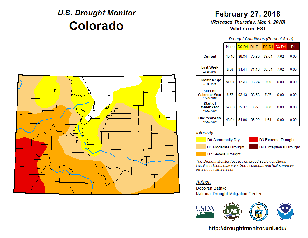
About 70 percent of Colorado is experiencing at least moderate drought conditions, and southwestern portions of the state are still seeing severe drought as hope springs eternal that the snow will come in March, traditionally Colorado’s snowiest month.
Ninety percent of the state is abnormally dry, according to the latest models from the U.S. Drought Monitor released Thursday. Just 10 percent of the state – primarily north-central Colorado and northeastern Colorado – is drought-free.
Denver sits on the edge between abnormally dry and moderate drought, as does much of the Front Range. But the further south and southwest one travels in Colorado at the moment, the drier things get.
Portions of eight southwestern Colorado counties are experiencing extreme drought, and most of southwest Colorado is in a severe drought period.
A year ago, half of the state was experiencing no drought, and just 37 percent of the state was seeing moderate drought.
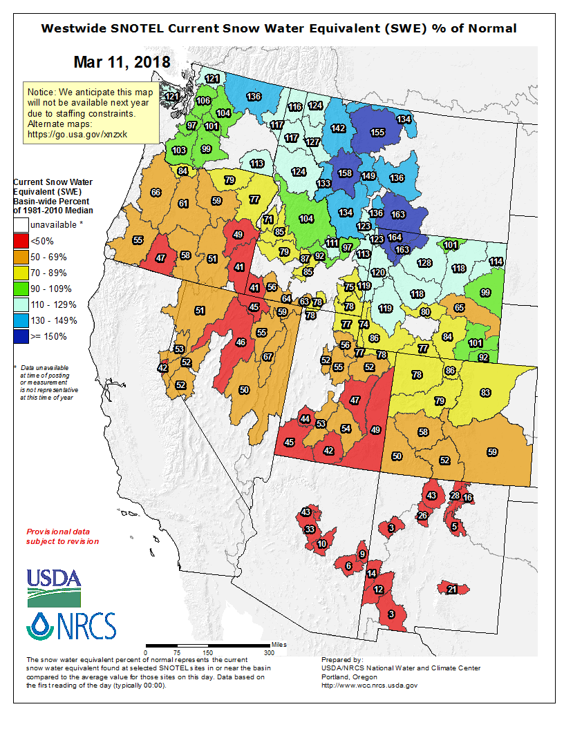
The state’s snowpack is also only at 71 percent of its normal levels, and just 52 percent of where it sat on March 1 last year. The Natural Resources Conservation Services, which tracks the snowpack, says the state would need 221 percent of its normal snowfall to reach the peak levels, which normally hit around April 9.
From the New Mexico Political Report (Laura Paskus):
Alejandra Calvo crosses a barren stretch of desert in Sonora, México almost daily during certain times of the year. The route could easily disappear beneath blowing dust and when rain does fall here, it renders the road impassable. There are no birds or wildlife here, not even any visible plants.
It wasn’t always like this: Until the 1960s, the Colorado River spread across this delta on its path to the Sea of Cortez.
Originally from Chiapas, Calvo is a biologist who works for ProNatura Noroeste, a conservation group based in northwestern Mexico. “Calvo is ‘bald’ in English,” she laughs, and tugs at her long blond hair spilling out from beneath her baseball cap. “That is not me.”
She drives this way to reach an unexpected wetland in the desert. About 30 miles south of San Luis Río Colorado—as the crow flies, not as the roads wind—lie 40,000 acres of salty lagoons and marshy wetlands. Shorebirds and migratory ducks and geese descend here by the tens-of-thousands. Migratory warblers and terns visit, as do rare birds like Yuma Clapper Rails and Piping Plovers.
La Ciénega de Santa Clara, the largest saltwater marsh in the Sonoran Desert, isn’t here because the ocean crept this far inland. Nor is it some remnant from when the Colorado River still reached the sea. Since the 1970s, a canal has dumped water too salty for farms here in the delta. For decades, the United States delivered water across the international border that included saline runoff from American farms. After a treaty amendment requiring the U.S. to reduce the salinity of its deliveries, that runoff was diverted to the Colorado River’s dry floodplain. And there grew La Ciénega de Santa Clara.
Today, as the motorboat passes between stands of cattails, American Coots squeak and flap off into the air. Calvo says families come out here during La Semana Santa, the Holy Week of Easter, and hunters and fishermen visit, too. But for the most part, it’s quiet.
The boat surprises two white pelicans, which lift off the water in a slow, heavy show of impatience. There are herons, too, and as the sun lowers in the winter sky, swallows swarm across the surface of the water, skimming up a drink. Back on shore, grackles hop across stands of saltbush, keeping a close eye on all that’s happening.
As cities and farmers in the United States, not to mention the warming climate, increase pressure on the Colorado River, the Yuma Desalting Plant is again looking like an attractive way to glean more water for Arizona. Built in 1992, the plant has only been operational twice. Were it running again, however, the ciénega would lose its water supply.
That has activists like Calvo, and the National Audubon Society’s Jennifer Pitt, worried. But there are also reasons for hope—here and upstream where Mexican and American activists have worked together on a restoration project in the Colorado River’s historic channel for about a decade.
Binational cooperation on the Colorado
About 40 miles from the ocean, Laguna Grande is the largest restoration site in the delta. The binational Sonoran Institute began work here on patches of existing habitat established when the river flowed through its channel in the late 1990s or early 2000s.
Soon, the project should cover about 800 acres, and it already employs more than 20 people, many of whom live in nearby villages. Families can visit the restoration project, and students come out to tour the newly re-established cottonwood forests. Beavers have returned here, as well as bobcats and coyotes. There are also rodents, raptors and rattlesnakes. The Sonoran Institute leases or buys water from farmers in the Mexicali Valley to support the wetlands, and the more than 250,000 trees they’ve planted here.
Walking through the cottonwood forest, Pitt says this landscape was destroyed before anyone figured out what to do about it. When the Colorado River started running dry in the mid-20th century, there weren’t yet environmental laws to temper or stop destructive operations or policies.
“We didn’t have a regulatory framework, we didn’t have courts, and we didn’t have any leverage,” Pitt says. “We figured that out at some point in the mid-2000s and figured out that as a conservation advocacy community our path forward had to be collaboration and cooperation. We had no choice.”
The United States and Mexico, as well as conservationists and stakeholders on both sides of the border, worked to bring a pulse of water through here in 2014, down the Colorado River to the Sea of Cortez—an initiative Pitt championed while working for the Environmental Defense Fund.
But whether talking about Laguna Grande or the pulse flow, Pitt is careful to note the delta is by no means fully restored. “When we say ‘restoration’…we mean there’s going to be a tiny, little ribbon of green that connects the Upper Gulf to the Colorado River,” she says. “That’s important. But that’s not the delta back again.”
The latest readings from the U.S. Department of Agriculture’s snow measurement sites at Vail Mountain, Copper Mountain and Fremont Pass show a mixed bag of “snow water equivalent.”
While Vail Mountain continues to have adequate snow for skiing and snowboarding, the measurement site continues to give below-average readings.
On Monday, March 5, the Vail Mountain site showed only 9.8 inches of snow water equivalent, below even the 12.5 inches recorded in the historic drought year of 2011-12. In that drought year, the snowpack at Vail Mountain peaked on Feb. 28 and then fell quickly. The Vail Mountain measurement site was melted off by April 8.
There’s better news from Copper Mountain — near the headwaters of Gore Creek — and Fremont Pass, near the Eagle River’s headwaters.
At Copper Mountain, the snow water equivalent is 79 percent of normal. The Fremont Pass site is right at the 30-year average…
UNCERTAIN OUTLOOK
We’re all hoping for more snow in the next several weeks, and it’s hard to tell just what those weeks will bring. Still, the outlook isn’t particularly promising.
Andrew Lyons, a meteorologist in the Grand Junction office of the National Weather Service, said the winter-long dry pattern seems to be holding.
An area of high pressure around the Southwestern United States and over the Pacific Ocean has been pushing storm systems to the north of Colorado all winter. That pressure ridge hasn’t moved much.
Lyons noted that we’re in the second year of a “La Nina” pattern — which develops due to cooler-than-average temperatures in the central Pacific. Those systems tend to bring more snow to Colorado resorts north of Interstate 70. Historically, though, the second year of La Nina patterns tend to be more dry than the first year.
Lyons said the current pattern has about run its course, which means the long-term outlook is uncertain.
The 90-day outlook from the U.S. Climate Prediction Center isn’t encouraging.
That forecast calls for a better-than-average chance of higher-than-normal temperatures and lower-than-normal precipitation.
Still, it’s springtime in Colorado. Just about anything can happen.
These are three different ways to describe how dry it is in Colorado right now. Those three categories are closely related … but not the same.
Think of it like this: Drought shows a deficit of moisture in the ground and soils. Fire danger shows a deficit of moisture in the fuels, which is in the trees, the branches, and on the ground.
Snowpack, at least this year, shows a deficit of moisture in the bank.
Together, these three categories show a more detailed picture of just how dry Colorado really is this year.
Seventy one percent of Colorado is in drought conditions as of March 5. That’s the largest drought our state has seen since September 2013, just before the historic floods.
This drought data gets updated once a week, by the National Drought Mitigation Center. It’s not a computer model. It’s put together by a person who weighs precipitation data, field measurements and satellite scans to subjectively report current drought conditions.
Thirteen different authors take turns putting together the reports. These authors range from drought experts, climatologists, hydrologists, meteorologists and agriculture experts.
The product they put out is called the U.S. Drought Monitor, and it’s meant for use in agriculture, by water managers, by governments that might need to implement water restrictions, and for every citizen to get a general understanding for available water.
The author of this week;s report, Deborah Bathke, told 9NEWS that drought is not a direct representation of fire danger, although it is closely related. Both products are driven primarily by lack of precipitation.
Fire danger shows both current and future conditions. Many areas along the Front Range of Colorado are listed in high or very high fire danger right now. That is due to the low moisture content in ground fuels like grasses, and shrubs, and even larger fuels like large tree branches, and limbs.
The Fire Danger Outlook is a forecast. The latest data shows a higher likelihood of above average wildland fire activity for southern Colorado through May, but average fire activity for the rest of Colorado…
Snowpack in our state is at record low levels at 9 Snotel observation sites, and is at 2nd lowest at seven other locations. Overall, Colorado is 30 percent below our average snowpack levels for March 5.
Westwide SNOTEL basin-filled map March 5, 2018 via the NRCS.
From the Associated Press (Susan Montoya Bryan) via The Cortez Journal:
Experts with the National Weather Service talked of snowpack levels in the mountain ranges that feed the state’s rivers ahead of the release Thursday of the latest drought map.
The map showed all but a sliver of southern New Mexico is grappling with dryness, with extreme drought increasing in the northwest corner of the state.
The absence of moisture elsewhere in the West also has become more common since the start of the year. Every square mile of Arizona, Utah and Nevada are mired in drought. Significant portions of Texas and Colorado have also fallen behind in snow and rainfall.
Royce Fontenot, a hydrologist with the National Weather Service in Albuquerque, said it would take more than the recent moisture to recoup the long-term effects of drought.
“Drought is like malnutrition. One meal is not going to catch you up,” he said.
The lack of moisture is beginning to be felt by agricultural communities in New Mexico.
The Spradleys have a contingency plan for drought. Just a trace of rain fell last summer, forcing them to sell their calves early along with heifers that would have been ready to have calves this year.
Now with the dry winter and unfavorable forecast, they made the decision to sell more. It will take years to rebuild the herd.
In the Mesilla Valley, farmer Jay Hill quickly sold his 2017 alfalfa reserves, and livestock are owners looking for more.
Most alfalfa grown in New Mexico is used by the dairy industry, and Hill said farmers and dairies will need to find middle ground on pricing.
Farmer also face pressure as irrigation sources are expected to be limited later this year.
“We’re not even in hay season yet and we’ve already got one strike against us because we’re having to use water just to keep the crop alive during the dry winter,” Hill said.
Governor Hickenlooper has declared this week “Flood Safety and Wildfire Awareness Week”. To go along with that, we’ll be touching on several related topics this week to help you prepare for these threats. We’ve had our fair share of experience with each issue, so it’s a good idea to always be aware of the potential for each situation.
Flooding can happen when there is heavy rain and/or rapid snow melt over a period of time. Flash flooding is a very sudden rise in water due to heavy rain or sudden breaks in ice jams, dams, or levees. Flooding can also occur when recently burned areas experience rain. We’ll discuss these types of flooding in more detail throughout the week.
For flooding, alerts are issued like they are for other severe weather events:
– A Flood Watch will be issued when flooding is possible within a certain area.
– A Flood Warning will be issued when flooding in imminent or has already been reported. When a warning is issued for your area it’s important to get to higher ground as soon as possible.
– A Flood Advisory can be issued for minor flooding along rivers and creeks.
– An Areal Flood Warning is issued for flooding in areas away from set river forecast points.
Nearly half of flood fatalities are vehicle related. Turn around, don’t drown. Never try to drive through flooded areas. The road underneath could already be washed away. Plus, just one to two feet of water can carry away most vehicles. It’s a better idea to back up and find another route.
From the Center for Snow and Avalanche Studies. Click through for the whole analysis. Here’s an excerpt:
SUMMARY
Colorado has begun March with low SWE conditions dominating most parts of the state. Only the Northern Front Range area and North Eastern Colorado has closer to average SWE conditions. This update summarizes snowpack conditions state-wide and evaluates March 1st snow water equivalent (SWE) data from SNOTEL stations associated with our eleven CODOS sites and places them within the framework of the Dust Enhanced Runoff Classification scheme (DERC) developed by CODOS. A summary is presented by individual Basin, and provides site-specific analyses for each CODOS site (linked at bottom of page).
SNOWPACK CONDITIONS
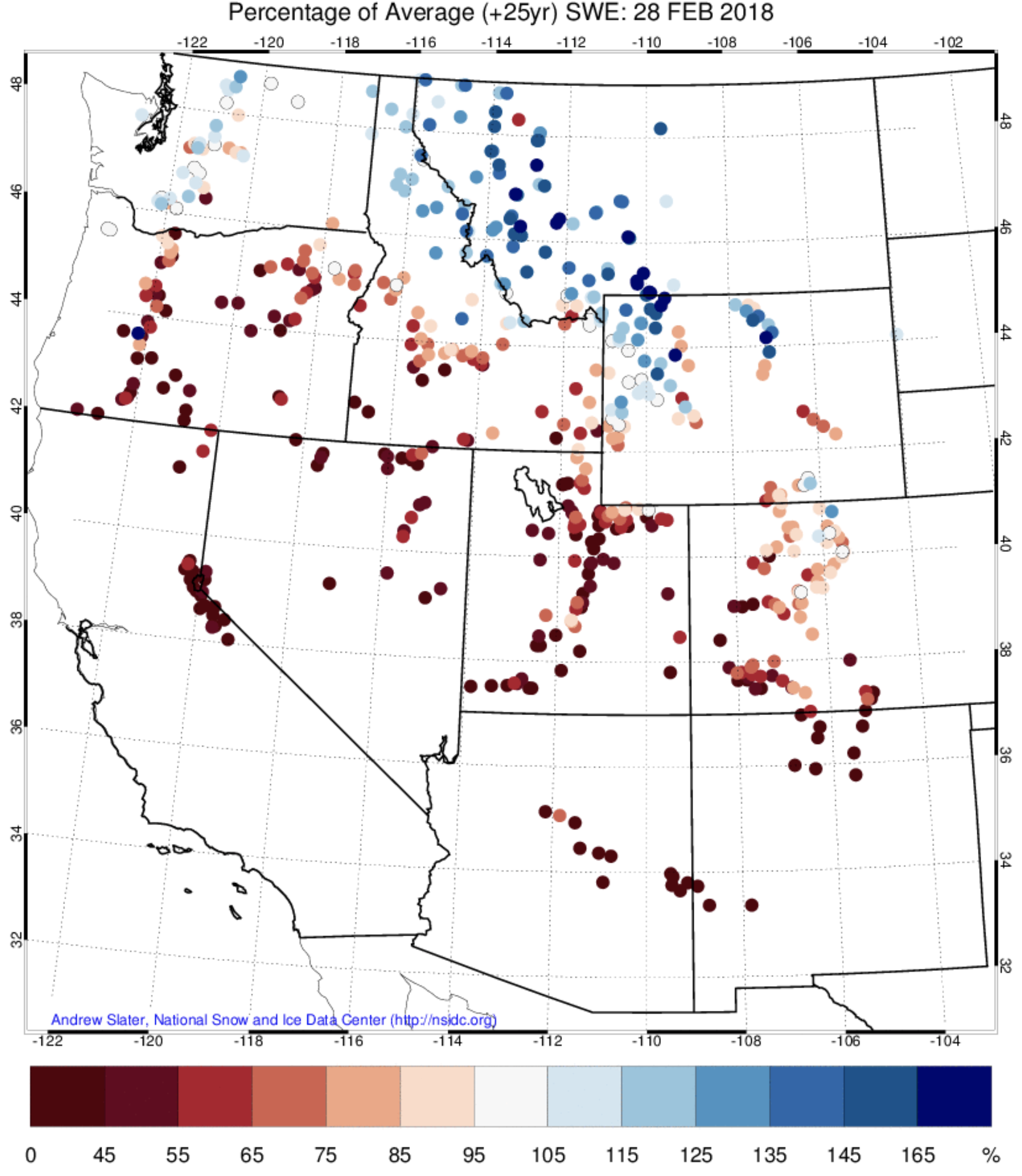
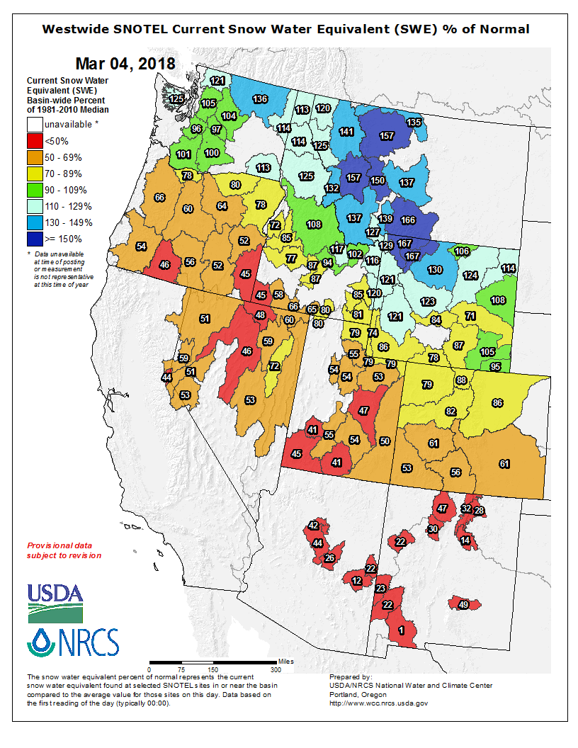
Snowpack conditions for this time of year are very low in many parts of the state. The average of the major basins’ percentage of median March 1st SWE is 74%. Individual SNOTEL station SWE throughout Colorado ranges from 21% at Grayback in the Rio Grande Basin to 131% at Buffalo Park in the Upper Colorado Basin. This winter’s drought is being felt in most parts of the Western United States, with the only major exception being the Northern Greater Yellowstone Ecosystem region of Montana, Idaho and Wyoming and parts of the Washington Cascades. Much of the Western US is seeing SWE conditions of less than half of median for this point in the year.
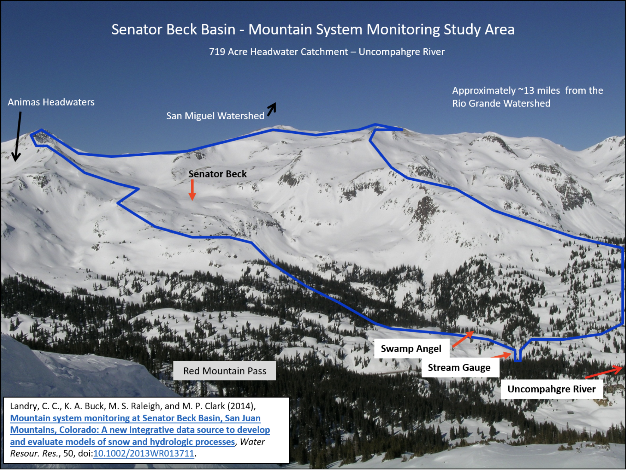
To augment SNOTEL data and better understand snowpack conditions it is important to consider data collected in Senator Beck Study Basin (SBSB). SBSB is located at, or near, the headwaters of four major watersheds (Animas, Uncompahgre, San Miguel, and Rio Grande) and is the only high alpine study site in the region collecting comprehensive snowpack information. Being a headwater study basin, the elevations that we collect snowpack information and continue meteorological station monitoring is well above the highest of most SNOTEL stations.
Senator Beck Study Basin location near Red Mountain Pass near Silverton, CO. Elevation of the Basin ranges from 11,030’ at the stream gauge to 13,510’ at the crest of the peaks. The blue line delineates watershed boundary. Senator Beck Study Plot and Swamp Angel Study Plot are the locations of highly instrumented meteorological stations and is also where snowpack data is collected. Credit: Center for Snow and Avalanche Studies
WINTER WEATHER SUMMARY: AN ABNORMAL PATTERN
The consistency of Northwest atmospheric flow during early part of winter lasting though January is responsible for the great disparity in snowfall across the West. For the majority of the winter there has been a stationary atmospheric ridge sitting over the west coast. This pattern is most prominent in the jet stream, a high elevation wind pattern which steers large scale weather systems like storms along it’s path. The resilient shape of the jet stream this winter has deflected and directed the majority of moisture-laden systems into a Northwest flow regime. This pattern heavily favors areas such as Montana while leaving California, Oregon, southern Idaho and Southwest US region high and dry. Here is a link to a great description about this “ridiculously resilient ridge” and it’s relationship to the historic fire season in California, and is very applicable to Colorado’s low snow year as well: http://weatherwest.com/archives/tag/ridiculously-resilient-ridge
El Niño Southern Oscillation (ENSO) has also contributed to this incredibly dry season as well. ENSO is a large-scale pattern in sea surface temperatures which has a major influence on weather in the Western Hemisphere. This coupled ocean-atmosphere phenomenon has been presenting moderate La Niña conditions this year, and some of the weather we have experienced over the winter can be linked to this pattern. La Niña conditions occur when cool sea surface temperatures dominate the equatorial region of the Pacific Ocean. It is typical of a La Niña year to see diminished snowfall and warm temperatures in the Four-Corners states and other regions of the Southwest US. We are now pleased to see ENSO conditions rapidly returning to neutral where they are expected to hover for the remainder of the winter. Hopefully this pattern shift will usher in additional spring precipitation so we can continue to build SWE in our basins through the spring.
Even with this ENSO pattern shift we are still expecting above average temperatures and below average precipitation through at least May. These long-term outlooks are rough estimates, but they are about as accurate as we can be at this point in predicting more long term climatological trends…
DUST-ON-SNOW AND DERC CLASSIFICATION
Over the course of our 2005-2018 period of rigorous observations, March 1st has marked the beginning of the heart of “dust-on-snow season” for the Colorado Mountains (see the CODOS Dust Log chart of dust events by month). So far for WY2018 at Senator Beck Basin, the primary ‘sentry site’ for the CODOS program, we have logged two dust events. The first of these only effected the early season snow and is now diffuse in the basal layers of the snowpack and will not have any hydrologic consequences. Our second event of the season came in on February 18th-19th and is a bit more than a meter off of the ground, meaning that once exposed this layer will impact melt rates in the spring. Currently this dust layer is hard to see due to its diffuse nature, but it may become more visible as settlement occurs, and once it coalesces at the surface it should be very visible. Unless conditions change, the CODOS team will do our first state-wide dust assessment of the season around March 19-23. We try to time our trips to best capture documenting dust in/on snow conditions, if there is plenty of fresh snow accumulation and minimal dust we delay the tour, but if we feel dust layers are near the snowpack surface we hit the road to determine the potential short-term and latter melt season impacts.
As of March 1st, Colorado SWE remains “low” among all major basins. DERC “Average” SWE equals day median +/- 10%, and deviation above and below those limits are assessed as having “high” or “low” SWE. The basins listed below are classified according to the appropriate DERC classification of either Low, Avg, or High March 1st SWE layer domains…
For individual SNOTEL stations associated with our eleven CODOS sites, March 1st SWE ranges from 48%-112% of median levels. March 1st SWE conditions were classified for the SNOTEL station directly associated with each CODOS site, and also for select nearby SNOTEL stations. Prior seasons with similar March 1st conditions were identified and placed within the appropriate dust enhanced March 1st SWE space. Local watershed hydrographs (from 2006-2017) associated with those March 1st SWE conditions are presented as plausible examples of runoff behavior in spring 2018, with the understanding that these prior years exhibit a limited variety of 2006-2017 dust and spring precipitation conditions for each CODOS site. Water forecasting in extreme years is particularly difficult. In this extreme dry year in most of Colorado many SNOTEL stations are reporting in the single digit percentile for their POR, the hydrographs included in the DERC classifications are worth reviewing to get an idea of what we could potentially be in for in terms of runoff behaviour. Many hydrographs in the DERC classification under low March 1 and dry spring conditions show peak streamflow upwards to a month earlier than the median for many watersheds.
Colorado River Basin in Colorado via the Colorado Geological Survey
FromThe Grand Junction Daily Sentinel (Dennis Webb):
The [Colorado River District], which includes Mesa County and 14 other counties and focuses on the protection, conservation, use and development of Colorado River water in western Colorado, long has been concerned about protecting the region’s agricultural sector. Now district staff are worried about a potential new threat to it, from investment companies buying water rights possibly as a speculative investment, and looking to profit later in deals that could lead to some local agricultural land no longer being irrigated and reverting to desert.
For the river district, the concern is keeping the Western Slope from eventually seeing the kind of widespread drying up of agricultural lands and withering of local farming and ranching economies that has occurred in areas of eastern Colorado over the decades as municipalities have bought up water rights.
District general counsel Peter Fleming addressed some of the acquisitions and their potentially speculative nature in a January memo to the board of the river district.
“For example, a New York hedge fund called Water Asset Management (through one of its many subsidiaries) acquired a 330-acre farm within the Grand Valley Project in mid-September 2017. While not a huge farm, that size is among the larger-sized parcels within the Grand Valley Project,” Fleming wrote in his memo, referring to the local Bureau of Reclamation irrigation project.
He told the board the farm’s associated historical consumption depends on numerous factors but could be about 840 acre-feet a year. An acre-foot is about 326,000 gallons.
That New York City company paid $3.83 million to Gary and Christi Flynn to acquire the farm located along 18 Road, well-known as the main access road to popular mountain bike trails on nearby federal lands.
In his memo, Fleming also cited a purchase by Boulder-based real estate investment and management company Conscience Bay Co. of western Colorado, including the 1,450-acre Harts Basin Ranch near Cedaredge in Delta County.
“To our knowledge, the properties continue to be operated as they have historically and there are no current plans to change the associated water rights or move the water off the land,” Fleming wrote. “However, it is clear that increasing water demands, reduced supply, and the potential risk of compact curtailment have put a more direct focus on West Slope irrigated agriculture. Stated another way, reality has caught up with our historical paranoia about the acquisition and potential dry-up of West Slope agricultural rights for speculative purposes.”
[…]
“While speculation in land and water rights is nothing new, the recent acquisitions appear to be keyed-in on acquisition of pre-compact water rights to hold for the present time but sell to the highest bidder during compact-curtailment/administration,” Fleming wrote.
Fleming said in an interview that in Colorado, senior, primarily agricultural water rights would have priority in the case of curtailment. That makes those water rights attractive to water users with junior rights, such as Front Range municipalities, which might be able to continue diversions under junior rights under a compact curtailment while sending water associated with a senior right downstream to make up for it.
Another concern for the river district is the prospect of financial agreements being made where the water isn’t used for irrigation but instead flows out of state, perhaps to be stored in Lake Powell and held in a buyer’s account should something such as a drought or compact curtailment occur.
DISTRICT, COMPANIES TALKING
Perhaps contributing to the river district’s concern is the fact that Water Asset Management’s website indicates that the investment vehicle it used in the Fruita acquisition primarily acquires water resources at agricultural value, with the intention of later reselling those resources to higher-value municipal, industrial and environmental consumers.
Water Asset Management didn’t return calls for comment for this story, and the Flynns declined to comment.
Conscience Bay representatives plan to meet with river district officials this month.
“I do think that we will be able to satisfy them that we’re not a threat. In fact, we’re going to be a partner with them in trying to help solve water problems,” said Eli Feldman, the company’s president.
Conscience Bay paid nearly $8 million last year to acquire not just the 1,450-acre ranch Fleming referred to in Fleming’s memo, but also adjacent acreage that resulted in a ranch 3,200 acres in size. Conscience Bay also has owned a 600-acre ranch in the Steamboat Springs area for about a decade, besides having commercial property investments.
“We’ve never sold any water to anybody,” Feldman said. “We’ve never done any (water) transfers of any nature, really.”
He said water is only a secondary interest for the company’s agricultural investments.
“Our primary interest in these ranches is their agricultural value and long-term food production,” he said.
He said the people at Conscience Bay are long-term investors, and the long-term appreciation of ranchland and farmland combined with the return on investment from ranching makes it a competitive investment compared to other options out there.
The river district’s new general manager, Andy Mueller, said the district is looking forward to its upcoming meeting with Conscience Bay representatives. He said district officials recently “had a good discussion” with representatives of Water Asset Management.
“I can say that they are actively acquiring properties in the Grand Valley,” Mueller said. “They also say they are primarily interested in them as working agricultural assets.”
He said the company expressed interest in participating in a voluntary, compensated temporary fallowing program.
Feldman said Conscience Bay likewise is interested in exploring things such as temporary fallowing that could free up some water for municipal, fishery, environmental or other uses. He believes such programs would provide agricultural operators some valuable income, especially in dry years when farming might be that much tougher. In times when agricultural commodity prices are low, it could help preserve ag land that might otherwise be subject to buying and drying to meet municipal needs.
“If you can add a new source of revenue for that (agricultural) community I think it would be fantastic and allow them to really hold out for the long haul,” Feldman said.
Fleming said it’s important that any such approach occur in a limited, measured way that protects collateral local economic interests such as sellers of fertilizer, trucks and farm implements, and that lands aren’t taken out of production for good.
For now, Mueller noted, while fallowing programs are being explored, none is in place on a permanent basis in the region.
“We want to make sure that (investment companies) have the information that indicates that the legal structure to engage in those kinds of behaviors does not exist today and it may not exist in the future, but it’s being studied,” he said.
He said the river district hopes to continue to be engaged with companies like Water Asset Management and Conscience Bay and emphasize the priority the district places on Western Slope agriculture.
“Frankly, we would like to study their financial models and their methods of operation to verify that the goal is really the long-term preservation of our agricultural communities,” he said.
He said the district is hoping to understand what makes the properties being acquired appear to be good investments from a water standpoint. He said a concern is that “investors who are not agricultural producers themselves may drive an economic model that would require a higher or faster return than a very limited fallowing program that may exist.”
WATER TIED TO LAND
Meanwhile, there’s a question as to what degree water investors could engage in activities such as being paid to let their water head downstream. Physically, Grand Valley water not consumed could flow across the state line, Mueller said.
“The question is, legally, does that model work? There are lots of reasons why it probably does not. That’s something that we’re looking at very closely,” he said.
Lots of considerations come into play, from local ditch company rules to state water law, under which not using the water could lead to potential abandonment of water rights, something the river district also doesn’t want to see happen, Mueller said.
Mesa County Commissioner John Justman said that if the buyers of the Flynn farm want to try to sell the water for use somewhere else, they face the fact that Grand Valley Project water rights stay with the land and can’t be sold separately.
“I don’t know that they did their homework,” Justman said.
Mark Harris, general manager of the Grand Valley Water Users Association, which operates part of the Grand Valley Project, said that while Grand Valley Project water rights can’t be sold apart from the land, the river district is nevertheless raising fair questions about things such as what latitude people might have to make deals involving not using water and letting it run downstream.
“We’re encouraged and are pleased that the river district is looking at this issue,” he said.
The users association has been involved with the river district and other entities in a pilot program to evaluate temporary, voluntary, financially compensated fallowing by farmers as a means of helping bank water in reservoirs in case of drought. Proponents want to ensure that if such an approach is pursued on a longer term, other forms of water conservation also are pursued that target other water users besides agriculture.
Harris said the users association is “certainly interested, in the face of increasing drought, in the pressure that’s going to be put on agricultural water throughout the West.”
He said any consideration of water demand management in an agricultural environment is something to which the association has to pay attention.
“People are trying to think about the future, knowing that it’s not going to look like the past and that some of the solutions we’ve looked at in the past aren’t going to fix the future,” Harris said.
The company last year bought the 1,450-acre Harts Basin Ranch south of Cedaredge, prompting the river district to wonder whether the purchase’s purpose was speculative, with the possible motive of looking to later profit on the ranch’s water rights in a manner that could mean drying up of agricultural land.
Feldman says the district need not be concerned (see main story) and that the principal reason for the investment is ranching.
Conscience Bay also bought additional adjacent acreage, resulting in a combined ranch size of 3,200 acres. Feldman said the ranch includes about 1,000 cows, and the company also has federal grazing permits in Colorado and Utah. Some six to 10 people run the ranch, which also includes a haying operation. Mark and Poly Hill, who have a ranching background in Grand County, are in charge of the ranch.
Conscience Bay is interested in joining in the discussion with the river district and others about concepts such as temporary fallowing to make water available for other needs in times such as droughts while keeping agricultural land from being permanently dried up. Feldman said his company has a strong conservation ethic. He now serves on the board of directors of the Western Resource Advocates conservation group, where he once worked, and he also enjoys outdoor activities like fishing and backcountry skiing.
Mike Higuera, who oversees the company’s investments in agricultural lands and its conservation work, previously was involved in land acquisition and conservation easement transactions for the Nature Conservancy.
The company is a Certified B Corporation, a certification that Higuera said is for companies that work to do good things for society beyond making a profit. The certification focuses on things such as how companies treat employees and give back to the community in ways such as charitable contributions.
The company is inviting the public to a meet-and-greet lunch at its recently acquired ranchland on March 17 in conjunction with Eckert Crane Days at Fruit Growers Reservoir, which is adjacent to the ranch. Directions to the ranch will be provided at the Black Canyon Audubon Society table at the festival.
It’s been many years since Gypsum faced a summer dry enough to warrant water restrictions. Gallegos noted that the town has made several improvements to its municipal water system since that time. It needed to, because Gypsum has also grown considerably over the past decade.
Gypsum Town Engineer Jim Hancock offered an overview of the Gypsum water system. The community currently has two treatment plants. The Norgaard Plant, located along Vicksburg Lane, is the town’s secondary plant, and the Mosher Plant, located south of the Brightwater development, is the town’s primary water-treatment facility. The source for the Mosher Plant is high-quality Mosher Spring…
Along with its treatment facilities, the town has storage capacity of 1,000 acre feet at Lede Reservoir. Hancock noted an expansion project at the Lede site was completed last summer to double its capacity. The town hopes to fill the reservoir this summer.
While the town has solid water sources, Gypsum wants to beef up its residential use education program.
“We want to let people know the connection between your lawn and the gutter,” Hancock said.
As Gypsum looks ahead to the summer, officials noted that typical winter municipal water use is around 1 million gallons per day. In the summer that jumps to 3.5 million gallons per day. They would like to keep that number under control if dry conditions continue.
DROUGHT PREPARATION
“The town plans for drought. Droughts occur,” said Kevin Patrick, Gypsum’s water attorney.
Patrick noted it wouldn’t be practical or financially feasible to plan a municipal water system to routinely meet drought year standards. Instead, towns and cities plan for normal conditions and then address drought needs through public participation in stricter restrictions. He noted that was the reason for the meeting — “to have everyone understand we are all in this together.”
Patrick praised past Gypsum water actions.
“Getting Lede was a coup,” he said, noting that it is unusual for towns as small as Gypsum to have such large storage capacity.
But Patrick added that on Feb. 1, snowpack readings for the Eagle River Basin were just 31 percent of normal.
“Now, we have had some snow, some rains since then,” he said. “We get 75 percent of our precipitation between Feb. 1 and April 15.”
Because slight weather pattern shifts can make a big difference in precipitation, Patrick said the Colorado high county could still avoid drought conditions this summer. However, the long-range forecasts aren’t very promising.
“So, what is the town going to do this summer if there is a drought?” Patrick said. “Part of today is to put it in everyone’s mind what they can and cannot do in their particular subdivisions.”
TOWN WATER WARNING
“Don’t use town water if you have a raw water system,” Patrick stressed. He then repeated that warning.
Several subdivisions in Gypsum — Cotton Ranch, Sky Legend, Chatfield Corners and Buckhorn Valley and more — have raw water systems in place for lawn irrigation. If residents run a hose to use treated municipal water for outdoor uses, then they are subject to fines. The penalties are $50 for a first occurrence, $200 for a second occurrence and $500 for each additional violation. Those charges will be added to individual water bills.
Using treated water for outdoor use in areas where non-potable systems are in service is just one violation that can generate a ticket when the town institutes Phase II or Phase III water restrictions. Phase II regulations mandate an alternating day schedule for lawn watering and irrigation hours before 9 a.m. and after 6 p.m. There are also restrictions about vehicle and equipment washing and other outdoor uses. If the town institutes Phase III regulations, then lawn irrigation and most outdoor uses are prohibited.
If the town institutes water restrictions, then the announcement will be posted on the town’s website by 9 a.m. the Wednesday after a regularly scheduled Gypsum Town Council meeting. Those meetings happen on the second and fourth Tuesdays of the month.
“The way we are going to get the word out is, first and foremost, it is your responsibility to check our website,” Gallegos said.
Because communication is a critical element of Gypsum’s water plan, Gallegos said that the water summit was the first step to reach out to residents about the town’s water rules. She noted Gypsum has compiled a lot of water information, everything from a comprehensive list of subdivisions served by raw water systems, to a list of voluntary and mandatory restrictions to information about drought surcharge fees.
About 50 people attended last week’s session, but Gallegos noted that the water summit information also is available online at http://www.townofgypsum.com.
Andrea Clark, Tom Kirkpatrick and Dana Black allege that Powderhorn bought a 1-cubic-foot-per-second winter water right that didn’t totally belong to the person who sold it to the resort. They also allege that removing more water from Mesa Creek in the winter will harm the other water users and worsen problems with the creek icing over, and that the ski resort can’t put the water it purchased to beneficial use at this time and bought the water rights on speculation.
The plaintiffs claim that Powderhorn should not be able to change the use of water it purchased from the Mesa Creek Ditch, which was formerly used during the winter for domestic and livestock purposes. The resort purchased the water from former Mesa Creek Ditch Association board president George Bevan.
According to court documents, Powderhorn intends to divert a maximum of 150 acre-feet of water during the winter, transport it to the H.U. Robbins Reservoir and store it there until it uses the water for making snow. The reservoir has a decreed capacity of a little more than 100 acre-feet of water and is located more than a mile from Mesa Creek, its source, according to state water records.
However, the plaintiffs allege that Powderhorn’s intent to use the water isn’t good enough — that the state’s requirement for water rights to be put to beneficial use should be applied here. In other words, they claim Powderhorn’s purchase of the water with no infrastructure for transporting it to its reservoir was speculative, which is not a legal use under Colorado law for those water rights. They also claim the resort’s reservoir needs significant repairs and has not been used for nearly 40 years, and that the resort hasn’t proved it can or will be able to transport or store the water.
Powderhorn’s attorneys claim the resort already proved the change in the water rights wouldn’t hurt any of the other water users and that Bevan owned and used the water he sold the resort for decades.
They also plan on calling Andy Daly, co-owner of Powderhorn, to testify that the water rights are necessary to have a reliable water source for snowmaking. This comes during a winter in which the resort didn’t open until the week before Christmas, snowpack levels are dismal and Powderhorn limited its operating days for weeks to keep its runs open with snow made by the resort.
Daly also plans on telling the court that Powderhorn will find one way or another to transport the water the 1.19 miles from Mesa Creek to its reservoir, though it does not have a way to do so currently, according to court documents.
“As for landowner access, Powderhorn can purchase, lease, or condemn the rights of way necessary to convey the subject water right to the ski mountain and H.U. Robbins Reservoir,” said the brief filed by the ski resort’s attorney, Glenn Porzak.
Other parties in the case include the Colorado Division of Water Resources and Ute Water Conservancy District, the largest domestic water provider in the Grand Valley. Ute Water became involved in the matter before the ski resort purchased the water in 2016, according to an agreement between the two entities that was signed by Ute’s board president at the time.
In the agreement, Ute Water agreed to not oppose Powderhorn’s application asking the state for permission to change the water right’s specified use to snowmaking. In exchange, Powderhorn offered shares of stock in the Mesa Creek Reservoir and Canal Co. and also said it would ask the state to let Ute Water have water that it bypassed and didn’t divert for snowmaking.
The plaintiffs are represented by Clark’s husband, attorney Jim French, who is handling the case pro-bono, and Isaiah Quigley, a Grand Junction attorney.
Thanks in large measure to warming temperatures, the average snowpack in U.S. western states has dropped by 15 to 30 percent since 1915.
The water in that lost snowpack is comparable in volume to Lake Mead. With a maximum capacity of 9.3 trillion gallons, Mead is the West’s largest manmade reservoir.
The new data on snowpack declines are among the striking results of a study led by Philip Mote, director of the Oregon Climate Change Research Institute at Oregon State University. As part of the study, Mote and his colleagues analyzed measurements from 1,766 snow-monitoring sites in the western United States going back more than a century. The researchers found that greater than 90 percent of those sites experienced declines in snowpack. Of those, 30 percent were found to be statistically significant.
“Declining trends are observed across all months, states, and climates, but are largest in spring, in the Pacific states, and in locations with mild winter climate,” Mote and his colleagues write in their paper, published on March 2 in the journal NPJ Climate and Atmospheric Science, a Nature publication.
“It is a bigger decline than we had expected,” Mote says, quoted in a release. The primary cause isn’t less snowfall, but warmer temperatures. “In many lower-elevation sites, what used to fall as snow is now rain,” Mote notes.
The West’s snowpack comprises nature’s own water storage reservoir — and a gargantuan one at that. “Mountain snowpack stores a significant quantity of water in the western U.S., accumulating during the wet season and melting during the dry summers and supplying much of the water used for irrigated agriculture, and municipal and industrial uses,” Mote and his colleagues write in their study.
Warmer temperatures bring spring-like weather earlier than in the past. As this trend continues, increasing spring rain and earlier runoff means declining water supplies running downstream from nature’s snowpack reservoir in summer and fall — just when farmers and cities have very significant water needs.
Researchers said the decline in snowpack is connected to warming temperatures. That could have a big effect on wildlife, agriculture, cities and towns. They depend on snowmelt to supply water during the dry summer and fall months…
The study found 90 percent of long-term snow monitoring sites in the West have less snow than 100 years ago. More than 30 of those sites saw significant decreases that could not have happened by chance, statistically, Mote said.
Researchers used a model that computed the amount of snow on the ground every day — using actual weather readings. They took the weather readings from 1,766 sites across the West. They ran the model over a time period of 100 years with real weather data.
They mostly keyed in on one date: April 1, historically a high-point for snowpack.
They found the biggest changes in snowpack in the spring in California, Oregon and Washington, and in places that had milder winters.
Then, they “re-ran the model without the warming trends that have been observed, and lo-and-behold, the large number of [declining snowpack] trends went away. It ended up being more balanced, 50-50,” Mote said.
They took that as another clear sign that snowpack is decreasing because of warmer temperatures, not a lack of precipitation.
One of place that’s seen the most snowpack decreases in the West is Eastern Oregon. Mote said the most recent low snow year in 2015 was a benchmark of where water problems have happened — and will continue to happen.
“The solution isn’t in infrastructure. New reservoirs could not be built fast enough to offset the loss of snow storage — and we don’t have a lot of capacity left for that kind of storage. It comes down to managing what we have in the best possible ways,” he said.
The study was published in NPJ Climate and Atmospheric Science, a Nature publication, and was funded by the National Oceanic and Atmospheric Administration’s Regional Integrated Sciences and Assessment (RISA) program, and the U.S. Environmental Protection Agency’s Office of Atmospheric Programs.
From the Hutchins Water Center (Hannah Holm) via The Glenwood Springs Post Independent:
In the fall of 2017, workers navigated sloppy mudflats in the bottom of the drained Paonia Reservoir in an urgent effort to prevent catastrophe: a damaged bulkhead threatened to break apart and damage the Paonia Dam’s outlet works, which would have made it impossible to control releases from the reservoir. This would have made the reservoir useless for delivering irrigation water and for flood control.
A temporary fix for the bulkhead problem was completed within budget and ahead of schedule, but reservoir managers still face longer-term challenges with managing sediment and keeping the reservoir functioning to sustain North Fork Valley agriculture over the long term. Related challenges are shared by many other water managers in western Colorado as they try to maintain aging infrastructure and respond to changing social values related to water management.
The completion of the Paonia Dam in 1962 enabled the continued growth of agriculture in the North Fork Valley. A beneficial micro-climate makes the valley well-suited for high-value fruit orchards — as long as there is sufficient water. Prior to the construction of the dam, many crops failed due to demand outstripping the supply of irrigation water in late summer. The dam currently provides water to irrigate approximately 15,300 acres of land.
When the dam was constructed, on the aptly-named Muddy Creek, it had a 50-year “sediment design life.” The designers expected the reservoir to fill with mud and become inoperable before now. Current constraints on what to do next weren’t anticipated, however. We are no longer in an era where new reservoirs can easily be constructed to replace old ones. Even fixing up old ones is complicated by legal constraints that didn’t exist in 1962, such as the need to ensure that the work does not have significant negative impacts on environmental, recreational or cultural resources.
The question of what to do next, within current constraints, can’t be avoided much longer. The mud has come close to overwhelming the intake structure that controls releases to the stream below the dam and has reduced the reservoir’s active storage capacity from 18,150 acre-feet to about 15,000 acre-feet.
The total volume of mud is staggering: the creek has been depositing an average of over 100 acre-feet/year of sediment to the reservoir since its construction in 1962. That’s about one football field buried 100 feet deep accumulating every year — a lot more than a whole convoy of dump trucks could haul off and sell as topsoil.
Intake structure during construction in 1961. Photo Credit Reclamation.
In recent years, the dam has been operated to pass a higher amount of sediment downstream, but the net inflow is still higher than the outflow. Finding a way to turn that around will require design changes to the dam outlet works and operations and careful assessment of potential impacts downstream of different release scenarios.
While streams below dams have often been described as “sediment starved,” with long-term, negative impacts to channel structure and aquatic habitat, too much sediment at once or at the wrong time can negatively impact the bugs at the bottom of the food chain and ruin fish spawning habitat.
These are tricky challenges, which Bureau of Reclamation staff are wrestling with now. And whatever fix is found is unlikely to be cheap. Doing nothing is not really an option, however, either for the agricultural life of the North Fork Valley or, in the long term, for the environmental health of the stream.
The same can be said for many of our aging dams, diversion structures and canals across western Colorado. Some of these are decades older than Paonia Dam. Examples include ailing dams on the Grand Mesa, leaking ditches, and inadequate control structures.
Numerous projects to address these problems are included in the basin implementation plans developed by basin roundtables of water managers and stakeholders in 2015 as part of a statewide water planning process. However, funding to implement such projects in the future has come into question as state severance taxes on oil and gas development, which have long provided funding for water projects in Colorado, have diminished substantially.
As this year’s dry winter underscores how tenuous our water supplies can be, it is worth the effort to carefully assess all the water infrastructure we rely on and determine how we can maintain it and improve it to optimize the benefits from every inch of snowpack we get.
Hannah Holm coordinates the Hutchins Water Center at Colorado Mesa University, which promotes research, education and dialogue to address the water issues facing the Upper Colorado River Basin. Support for Hutchins Water Center articles on water issues is supported by a grant from the Walton Family Foundation. You can learn more about the center at http://www.coloradomesa.edu/water-center.
For about 24 hours starting the evening of February 18th, the snow blew hard across western Colorado leaving up to 8 inches in southwestern parts of the state, according to the National Weather Service. Wind speeds at one point reached 115 miles per hour at high elevations. While the storm brought needed moisture, Jeff Derry of The Center for Snow & Avalanche Studies in Silverton, noticed that it carried something else besides snow—dust.
Derry said that as the wind and snow were blowing sideways you could see dust within the snow and on the ground and collecting in eddies. It was very noticeable while the storm was happening, and even saw the dust blowing on sidewalks. Two of his employees noticed the dust while driving some miles away on Red Mountain Pass. It was also noticed as far away as Aspen Mountain and Beaver Creek. The dust is swept up from the Colorado Plateau, an area in southern Utah and northern Arizona, which Derry said is the main source of particulates for the state of Colorado.
A recent study from the University of Colorado points out that dust on and in snow may be more important than temperature in determining when snowmelt will reach rivers and reservoirs. The dust collects heat from the sun and causes snow to melt faster and even earlier in the runoff season.
That can be a problem for water providers. Kalsoum Abbasi, a water engineer with Colorado Springs Utilities said that, if there’s too much runoff, they can’t collect all they are entitled to divert, and it continues down the river. Early melting can also have an effect on river ecology. Abby Burk is the Western Rivers Program Lead for Audubon Rockies. She said intense and early runoffs can affect aquatic insects, riparian trees and shrubs—and even change river channels.
So what will be the effect of this recent dust event? To figure that out Jeff Derry and his colleagues look for dust in Colorado’s snowpack by digging snow pits—a method for which he says there is really no substitute. By doing that they see the layers of dust and can analyze its effect on runoff. They go all around the Colorado mountains, north to south and east to west digging snow pits to measure the dust layers. Spring months are the biggest ones for dust events, so Derry’s team will go dig pits in March, April and May. They’ll share what they find with water managers and river forecast centers.
But, as far as this recent dust event goes, they won’t know the impact until they’ve dug all those snow pits.
Gov. Doug Ducey’s administration wants legislative authority to allow water users to skip delivery of some of their allocation this year to prevent shortages in future years. Such legislation would ensure that, if they leave the water in the reservoir, they can retrieve it later if river conditions improve.
The Central Arizona Project — whose canal delivers the water to Phoenix and Tucson — has opposed the idea, preferring to stick with existing programs. The agency has made the argument that holding small amounts of water in Lake Mead as the state proposes could backfire and bring shortages sooner.
So far, lawmakers have not introduced the legislation Ducey would need to make the idea work.
A shortage on the horizon?
The latest federal forecast predicts only about half the normal water will flow into the Colorado River system because snow has failed to pile up in the Rocky Mountains. If water users take their full allocations, reservoir storage will shrink faster.
“We need to act,” said Hunter Moore, the governor’s natural resource policy adviser.
The administration wants authorization to let users who are willing, such as some of the tribes controlling nearly half of the water flowing through CAP’s canal, to leave a portion of their water behind Hoover Dam. There, it could prop up Lake Mead’s elevation and slow a decline that otherwise could cause federal officials to reduce Arizona’s river diversion.
Such a shortage, which Arizona years ago agreed to take if the reservoir falls below 1,075 feet above sea level, would mainly affect central Arizona farmers.
But state officials fear a mandated reduction in water flowing toward Phoenix would look bad to outsiders, who could question whether the state has water for growth and business, and that further declines in Lake Mead would trigger more draconian cuts.
Banking water in the reservoir for later use, as the Arizona Department of Water Resources proposes, could prevent the shortages, officials said.
Finding the right balance
CAP officials argue that conserving too much too quickly could rob Arizona of water and force it to raise rates on millions of Arizonans to pay the canal’s bills even as the CAP sells less water through it.
The crux of the dispute is a set of federal guidelines by which the U.S. Interior Department tries to balance Lake Mead’s elevation with that of Lake Powell, the reservoir farther upstream.
In normal years the government releases at least 8.23 million acre-feet from Lake Powell to flow into Lake Mead, each acre-foot equaling the needs of about two households. That water essentially covers all of the approved uses in Arizona, California, Nevada and Mexico.
When Lake Mead shrinks, the government can send more downstream to keep levels up. In recent years, that has meant 9 million acre-feet flowing toward those users. It’s a flow that could dry up if Arizona’s conservation measures push Lake Mead’s elevation too high.
The risk to Arizonans is that they could conserve enough to elevate the lake and reduce the extra water from Powell, but not enough to prevent bad winters from triggering a shortage in two or three years anyway, CAP General Manager Ted Cooke said.
That would mean an immediate loss of the water that otherwise could have flowed through the canal and helped pay its bills in the interim.
“There will be a shortage unless the drought miraculously ends,” Cooke told a group of reporters visiting his headquarters on an Institute for Journalism & Natural Resources fellowship last week.
Cooke said CAP and others are already collaborating on funding farm efficiency and other measures to shore up Lake Mead. He advocates boosting those programs instead of stashing tribal water.
Do too little, lose a lot?
The Ducey administration acknowledges that raising Lake Mead too much could lead to short-term losses, but insists that doing too little could lead to more calamitous losses later on.
For instance, letting Lake Mead slide another 50 feet lower would cause Interior to shut off nearly a third of CAP’s water, severely affecting Phoenix and Tucson. It could happen if conservation volumes remain flat and winter snows keep underperforming.
The city of Phoenix has supported the state’s plan to push more conservation, even if reducing canal deliveries cuts into the water the city has taken and stored in the ground in recent years.
“Phoenix is willing to make those tradeoffs,” said Kathryn Sorensen, director of Phoenix Water Services. “We take a very long-term view of the river.”
The state needs to get the tribes to store water in Lake Mead before too many more dry winters make it too late, Arizona Water Resources Director Tom Buschatzke said.
“The tribes are not going to do it,” he said, “if CAP is the one that holds it in their names and dribbles it out as they see fit.”
CAP’s position is that its elected board has done well to conserve the right amount without causing federal managers to slow the flow into Lake Mead. The agency can increase those efforts without cutting back on canal flows that will hurt ratepayers, Cooke said.
The state wants more.
“A plan to let nature replenish the system is not a plan, right?” Buschatzke said.
Lead organizer Ed Archuleta, Director of Water Initiatives for the University of Texas at El Paso, welcomed the diverse audience to the “Olympics of Water on the Border” at the TecH2O Learning Center located at 10751 Montana Avenue.
“Despite all the rhetoric in the news about building border walls and immigration issues, those of you in the water industry know that water is the most important issue on the U.S.-Mexico border,” said Archuleta. He invited participants “to share ideas so we can continue to have a robust and economically viable border region.”
“Establishing partnerships is vital to navigating water issues on the border,” said El Paso Water President and CEO John Balliew. “It’s very important to have cooperation when dealing with this key resource. Our triangle of relationships between EPWater, the region’s universities and the U.S. Bureau of Reclamation is key to solving many of these issues.”
Speakers and participants engaged on topics such as drought, the Colorado River Agreement – Minute 323 and research on innovative technologies including water reuse and desalination.
A number of ideas were advanced throughout the two days to further cross-border cooperation and advance innovations that support the vitality of the border region. Among the ideas that generated the most discussion were:
Begin to work on a cooperative binational framework focused on aquifers that cross state and national borders; and
Examine new economic models that value water and water infrastructure appropriately for long term sustainability.
Commissioner Roberto Fernando Salmón Castelo, of Mexico’s International Boundary and Water Commission (CILA), said the international conference and ongoing dialogue will help strengthen U.S.-Mexico bonds.
“We want water to be a theme that unites us, not divides us,” Salmón said.
Linear trends in 1 Apr SWE relative to the starting value for the linear fit (i.e., the 1955 value for the best-fit line): (a) at 699 snow course locations in the western United States for the period 1955–2016, with negative trends shown by red circles and positive by blue circles; (b) from the simulation using the VIC hydrologic model for the period 1955–2014 (cells in gray have mean April 1 SWE less than 5 mm; areas in white are not simulated); (c) as in (b) but using temperature data in which linear trends have been removed for the 1954-2014 period. Lines on the maps divide the West into four regions for analysis shown in subsequent figures
Here’s the release from Oregon State University (Mark Floyd/Philip Mote):
A new study of long-term snow monitoring sites in the western United States found declines in snowpack at more than 90 percent of those sites – and one-third of the declines were deemed significant.
Since 1915, the average snowpack in western states has declined by between 15 and 30 percent, the researchers say, and the amount of water lost from that snowpack reduction is comparable in volume to Lake Mead, the West’s largest manmade reservoir. The loss of water storage can have an impact on municipal, industrial and agricultural usage, as well as fish and other animals.
Results of the study are being published today in NPJ Climate and Atmospheric Science, a Nature publication.
“It is a bigger decline than we had expected,” said Philip Mote, director of the Oregon Climate Change Research Institute at Oregon State University and lead author on the study. “In many lower-elevation sites, what used to fall as snow is now rain. Upper elevations have not been affected nearly as much, but most states don’t have that much area at 7,000-plus feet.
“The solution isn’t in infrastructure. New reservoirs could not be built fast enough to offset the loss of snow storage – and we don’t have a lot of capacity left for that kind of storage. It comes down to managing what we have in the best possible ways.”
The researchers attribute the snowpack decline to warmer temperatures, not a lack of precipitation. But the consequences are still significant, they point out. Earlier spring-like weather means more of the precipitation will not be stored as long in the mountains, which can result in lower river and reservoir levels during late summer and early fall.
The study considered data from 1,766 sites in the western U.S., mostly from the U.S. Department of Agriculture’s Natural Resources Conservation Service and the California Department of Water Resources. The researchers focused on measurements taken on April 1, which historically has been the high point for snowpack in most areas, though they also looked at measurements for Jan. 1, Feb. 1, March 1, and May 1 – which led to the range of decline of 15 to 30 percent.
They also used a physically based computer model of the hydrologic cycle, which takes daily weather observations and computes the snow accumulation, melting, and runoff to estimate the total snowpack in the western U.S.
“We found declining trends in all months, states and climates,” Mote said, “but the impacts are the largest in the spring, in Pacific states, and in locations with mild winter climates.”
The Pacific states – California, Oregon and Washington – receive more precipitation because of the Pacific Ocean influence, and more of the snow falls at temperatures near freezing. Because the Cascade Mountains, which transect the region, are not as steep as the Rocky Mountains, they have more area that is affected by changes in temperature.
“When you raise the snow zone level 300 feet, it covers a much broader swath than it would in the inland states,” Mote said.
Mote was one of 12 lead authors on a chapter of the fifth Intergovernmental Panel on Climate Change report looking at the cryosphere, which is comprised of snow, river and lake ice, sea ice, glaciers, ice sheets and frozen ground. Also an author on the fourth IPCC report, he had led a 2005 study on western snowpack levels that had also documented declines that were less dramatic than those in this new study.
This latest study found:
California had the highest number of positive snowpack trends since 1955, but lingering drought during the past decade erased most of those gains and snowpack declines still dominated;
Most of the other western states had only one or two sites that reported increases in snowpack;
Regions with the most significant decrease in snowpack were eastern Oregon and northern Nevada, though snowpack decreases in excess of 70 percent also occurred in California, Montana, Washington, Idaho and Arizona.
“The amount of water in the snowpack of the western United States is roughly equivalent to all of the stored water in the largest reservoirs of those states,” Mote said. “We’ve pretty much spent a century building up those water supplies at the same time the natural supply of snowpack is dwindling.
“On smaller reservoirs, the water supply can be replenished after one bad year. But a reservoir like Lake Mead takes four years of normal flows to fill; it still hasn’t recovered from the drought of the early 2000s.”
Mote said snowpack levels in most of the western U.S. for 2017-18 thus far are lower than average – a function of continued warming temperatures and the presence of a La Niña event, which typically results in warmer and drier conditions in most southwestern states.
The study was funded by the National Oceanic and Atmospheric Administration’s Regional Integrated Sciences and Assessment (RISA) program, and the U.S. Environmental Protection Agency’s Office of Atmospheric Programs.
Mote is on the faculty of OSU’s College of Earth, Ocean, and Atmospheric Sciences. Other researchers on the study include Sihan Li, University of Oxford; and Dennis Lettenmaier, Mu Xiao, and Ruth Engel of the University of California, Los Angeles.
Here’s the abstract from the paper:
Abstract
Mountain snowpack stores a significant quantity of water in the western US, accumulating during the wet season and melting during the dry summers and supplying much of the water used for irrigated agriculture, and municipal and industrial uses. Updating our earlier work published in 2005, we find that with 14 additional years of data, over 90% of snow monitoring sites with long records across the western US now show declines, of which 33% are significant (vs. 5% expected by chance) and 2% are significant and positive (vs. 5% expected by chance). Declining trends are observed across all months, states, and climates, but are largest in spring, in the Pacific states, and in locations with mild winter climate. We corroborate and extend these observations using a gridded hydrology model, which also allows a robust estimate of total western snowpack and its decline. We find a large increase in the fraction of locations that posted decreasing trends, and averaged across the western US, the decline in average April 1 snow water equivalent since mid-century is roughly 15–30% or 25–50 km3, comparable in volume to the West’s largest man-made reservoir, Lake Mead.
The confluence of the Green and Yampa rivers in 2016. How much water reaches this point, bound for Lake Powell, has implications across the west and Colorado, and an ongoing water study might suggest how to manage water in a severe drought. Photo credit Brent Gardner-Smith.
Although Colorado has the right to develop its unused compact water, as does Wyoming, those involved in Wyoming water issues note that this project could result in major changes in how water is managed in the basin, since it changes how much water will be headed downstream from Flaming Gorge.
The first time was expected to divert 250,000 acre-feet of water, and to cost $3 billion. After working with the Army Corps of Engineers on the project for two years, the Corps cancelled Million’s application in July of 2011.
The second try
Million immediately tried again and proposed tapping into the Green River at two sites – one just three miles below the city of Green River, Wyoming and the other from the western edge of the Flaming Gorge reservoir. Although the amount of water he wanted was the same, this time, Million quoted the cost as between $7 billion and $9 billion because he was adding a hydropower component to the plan. Thanks to the hydropower aspect, this new project would be under the authority of the Federal Energy Regulatory Commission (FERC).
A Western Resource Advocates study on the second proposal predicted that not only would the water supplied by the pipeline cost up to ten times the price of water from other developments, it would also lower the level of the popular Flaming Gorge Reservoir by 10 feet – hurting fishing and tourist traffic in the Gorge, and river rafters along the Green and Colorado rivers by $58.5 million a year.
A coalition of more than 250 businesses from seven states; ten conservation groups and Sweetwater County and the City of Laramie fought the development, along with Wyoming Governor Matt Mead, who wrote a letter to FERC that said in part, “”This project would cut a vast swath across southern Wyoming, with the potential for huge impacts in many significant sectors of our economy and aspects of critical resources to Wyoming and Colorado.” Mead also objected to the 25,000 acre-feet of water per year belonging to Wyoming that Million was including in his proposed ‘take.’
When the FERC dismissed Million’s application as “premature” in February of 2012, Million was unfazed and told the Denver Post that, “The FERC dismissal has zero to do with us moving forward.”
The third time
In April of 2012, Million argued his case in a guest column for the Northern Colorado Business Report (at the time a sister paper to the Wyoming Business Report), claiming that less than 5 percent of the “massive Flaming Gorge Reservoir” would be pumped to Colorado’s Front Range annually. Meanwhile, it would help northern Colorado face its own water supply shortfalls.
“If it is environmentally sound, it should be permitted and built,” Million wrote in the column, seemingly addressing the myriad environmental groups voicing fervent opposition to the pipeline. “If not, then stick a fork in it. The truth of a full scientific and environmental evaluation may be hard for some in the environmental community to swallow, but the consequences of not allowing that evaluation to occur remain.”
As the Wyoming Business Report’s Mark Wilcox wrote at the time; “Aaron Million’s confidential business plan to annually pump about 81 billion gallons out of Flaming Gorge and the Green River that feeds it has been revealed to the Associated Press, and it is no small wonder he has not taken ‘no’ for an answer. The plan would bring in an estimated net profit of between $1.4 and $2.4 billion. And that’s after construction costs of somewhere between $2.8 billion and $3.2 billion. And end users of the water would pay up to $117 million in annual operating costs based on a ‘cost plus 20 percent’ business model with estimated operating costs of between $70 million and $90 million.”
Million was granted a FERC hearing on his third proposal on April 23, 2012. Then his proposal was was rejected. “FERC’s ruling doesn’t affect us from the standpoint of continuing to move forward,” Million told the Wyoming Business Report at the time in a phone interview. However, the FERC denied him a re-hearing.
“We are not persuaded by any of Wyco’s unsupported arguments that it should be issued a preliminary permit,” the commission said in its filing…
Is the fourth time a charm?
This January, Million was back with a new approach. This time, he started by petitioning Utah for the water rights. This approach – petitioning for water to export from Utah – was so unusual that the state didn’t even have a form to fill out for it.
Rob Harris, senior staff attorney at Western Resource Advocates (whose Wyoming ties include a grandfather from Basin) notes that the problem with petitioning for water rights as an individual is that “All three states have an anti-speculation doctrine in our water rights laws. [Million] doesn’t actually stand in the shoes of any actual Colorado water users. It’s really basic stuff he’s running up against – it’s why this has floundered in the past, and will continue to flounder until he’s made contractural arrangement with people who he’s going to supply water to.”
An examination of Million’s application with the state of Utah has the all eventual users of the water identified as “TBD.”
Harris points to a previous case in which water from the Arkansas Valley was eyed for the Front Range. “The court said ‘No way! You don’t have any contracts.’ It would be one thing if it were a city doing this, but this is just a guy trying to make money.”
In addition to the change at the start of the process, Million’s fourth try has a few key differences to the last ones. First, he’s moved the point of diversion 50 miles southeast into Utah, away from the Flaming Gorge Reservoir, which should be some relief to the Wyoming outdoor recreation industry – but less comfort to Colorado River rafters.
Second, he’s reduced the amount of water he wants to take each year from 250,000 acre-feet to 55,000 acre-feet. “It’s less water than last time,” Harris admits, “but it’s still a heck of a lot. You could run a pretty good-sized city on 55,000 acre-feet a year.”
Third, he’s changed the name of the company he’s operating from Wyoco Power and Water Inc. to Water Horse Resources LLC.
“I think he’ll point to the tons of growth in the Front Range, and that there is a gap between known [water] supplies and what’s needed to meet the expected population growth,” Harris said. “But if you look at the really big players in water on the Front Range (Denver Water, Colorado Springs, Aurora, Northern Water Conservency District), they’re all pursuing alternative sources [not tapping into the Green River]. They are emphasising creative ways to conserve and share the local water supply.”
High Line Canal Regional Context map via the High Line Canal Conservancy
Click here to read the newsletter. Here’s an excerpt:
Framework Planning Open Houses
The High Line Canal Conservancy has launched the second phase of significant planning for the High Line Canal, a beloved 71-mile regional trail. This multi-jurisdictional planning initiative follows on the heels of the Community Vision Plan completed in early 2017. This planning phase will focus on a Framework Plan – a multi-year implementation plan to ensure that the Canal reaches its greatest potential as an environmental, recreational, social, historic and economic asset. It will include complete plans for signage and wayfinding, as well as landscape guidelines for all 71 miles.
The first phase of public open houses for the Framework Plan is in April. The open houses will include an existing conditions analysis, preliminary signage designs, and an opportunity for input on potential enhancement projects and project priorities. Continued support and engagement from the citizens of the region is vital to ensure the future of the Canal is reflective of the public vision. Come share your thoughts in April!
Tuesday April 10th, 4:30-7:30 pm
Goodson Recreation Center – 6315 S. University Boulevard
Thursday April 26th, 4:30-7:30 pm
Aurora Central Library – 14949 E. Alameda Parkway
Click here to read the update from the Colorado Water Conservation Board and Colorado Division of Water Resources (Taryn Finnessey/Tracy Kosloff):
2018 has started off warm and dry across most of the state with very few below average temperatures; and despite recent precipitation, it is unlikely that many basins in the southern half of the state will be able to reach average snow accumulation this season. 71 percent of the state is in some level of drought classification with 38 percent in moderate drought, 26 percent in severe drought and 8 percent classified as extremely dry. An additional 20 percent of the state is experiencing abnormally dry conditions. Mesa Verde National Park is currently experiencing the driest conditions on record (1923). Water providers are cautiously watching conditions but most have above average amounts of water in storage.
As of February 21, statewide precipitation at SNOTEL sites is 70 percent of average, with all of the basins improving as a percent of normal compared to last month. The North and South Platte basins have experienced the highest levels of precipitation in the state, at 95 and 103 percent, respectively. Despite recent gains, southern basins such as the Southwest basins of the San Miguel, Dolores, Animas & San Juan, Rio Grande and Gunnison basins remain below normal precipitation at 42, 51 and 55 percent respectively. Conditions are also dry in the Arkansas Basin at 61 percent of average annual precipitation to-date. Several attendees pointed out a concerning lack of snow at foothill elevations in the Front Range.
Statistical analyses indicate that it will be hard for the state as a whole to reach normal snowpack given current conditions; however this varies from basin to basin with southern basins significantly drier than those in the north.
Reservoir storage statewide is at 115 percent of normal, with all basins above average. The Arkansas basin is reporting the highest average storage at 143 percent. The Gunnison basin has the lowest storage levels in the state at 104 percent of normal.
Both the SWSI and stream flow forecasts are based on conditions as of February 1, before several storms provided moisture to high mountain elevations. SWSI values declined compared to January 1, especially in the southwestern and south central part of the state. Stream flow forecasts are largely below normal statewide.
Water providers in attendance report their respective system storage levels are at or above average for this time of the year, but the lack of snowpack in concerning and being closely monitored. The majority of representation was from providers in the South Platte Basin, which is currently has the highest snowpack in the state.
Short term forecasts show that temperatures will be more seasonal with a normal chance of precipitation, however longer term forecasts indicate increased likelihood of below average precipitation and above average temperatures.
A weak La Niña remains in force for now, and forecasts indicate that warm and dry conditions are likely to persist through the spring. It is unclear what will happen during the summer months.
Storm drain and open channel improvements between the East Rail Line (38th & Blake Station) and the South Platte River (Globeville Landing Outfall), Stormwater detention/conveyance between the East Rail Line (38th & Blake Station) and Colorado Blvd, (Montclair Basin) Stormwater detention/ conveyance immediately east of Colorado Blvd. (Park Hill Basin).
Denver Public Works refers to that problem area as the Montclair basin. It is the largest basin in Denver at 9.5 square miles, that does not have a path for stormwater to get to the South Platte River.
So they say that stormwater tends to pool in that area, and some of the worst flooding in the city steams from this spot. The solution, according to Denver Public Works, is to build the largest flood protection project that Denver has ever seen.
The Platte to Park Hill Project, or P2P, is extremely progressive in its use of open channels, water quality features, and inclusion of community and recreational assets.
A 9NEWS crew toured the nearly completed first phase of this plan, called the Globeville Landing Outfall Project, which Denver Public Works describes as a giant storm drain.
The centerpiece of this project is a massive pipe that’s actually a 500-yard-long, 12 foot by 15 foot – a concrete box culvert…
This project will protect those historic neighborhoods around the Denver Coliseum, like Elyria, Swansea, Cole, Whittier, Clayton, Skyland, and Five Points.
Denver Public Works said it will not only handle the routine stormwater, that often floods those areas, but also the big 100-year events.
“It’s those storms that are above an inch in an hour. Two inches, three inches in an hour, those are the ones we don’t have a system for, those are the ones that this system is really going to do a good job for us,” said Uhernik.
A thunderstorm that covers all 155 square miles of Denver, with just 1 inch of rain, puts down 2.7 billion gallons of water, which is enough to fill about 67 million bathtubs…
In this new project, the water will flow out of that culvert and into the open, where it will run through a new park and into the South Platte River, just along the west end of the Denver Coliseum parking lot.
It’s a natural path restored.
Denver Public Works says this drain will be ready to take on stormwater by this summer. The new city park will be completed in the spring of 2019.
They plan to build similar drains downstream in the years to come.
Luke Runyon near Hoover Dam power plan February 2018 via Colorado State University.
Here’s the release from Colorado State University:
The Straayer Center for Public Service Leadership will host a lunch event called “Tales from the Colorado River” featuring KUNC’s Luke Runyon on Wednesday, March 7.
The event, which is free and open to the public, will be held from noon to 1 p.m. in the Lory Student Center, Room 322.
One of Colorado’s best storytellers, Runyon will discuss his new work focusing on water in Colorado and the major lessons he’s learned. Those include lessons regarding natural resources and public policy that are critical for students interested in careers in public service.
The event is a BYO Brown Bag Lunch & Learn, and the presentation will include a question-and-answer session.
Space is limited; RSVP to shoughte@colostate.edu.
The Straayer Center for Public Service Leadership is based in the Department of Political Science, which is part of CSU’s College of Liberal Arts.
Click here to go to the US Drought Monitor website. Here’s an excerpt:
Summary
This past week was marked by heavy rain across the mid-South and lower Midwest. The excessive rain broke daily precipitation records, caused flooding in many locations, and led to significant improvements to drought. The upper Midwest received significant snowfall as colder than normal temperatures dominated the area. Precipitation also fell in other parts of the country including the northern Plains, Northeast, and much of the West. Dry weather was confined to southern California, the Desert Southwest, and lower Southeast. A stark temperature contrast existed between the western and eastern halves of the country. While the West saw record-breaking cold, the East saw record-breaking warmth. Temperatures in the West were typically between 8 and 12 degrees below normal, though the northern Rockies and High Plains saw departures of more than 20 degrees below normal. In the eastern half of the country, departures ranged from 2 to more than 20 degrees above normal…
West
An upper-level trough persisted in the West this week, bringing cool temperatures to all areas and moderate to heavy precipitation to parts of Idaho, western Oregon and Washington, the San Juan and Snowy Ranges in Colorado and Wyoming, and the Sierra Nevada. Abnormal dryness developed in northeastern lower Idaho as seasonal precipitation deficits intensified. Severe drought was introduced southeast Utah as water year precipitation and snow water equivalent are ranked in the lowest percentiles. Urban areas of southern California already in severe drought have continued to experience largely dry conditions; conditions remain at status quo because of the recent rain and lack of widespread water supply issues…
High Plains
Some light to moderate precipitation fell in central and eastern Nebraska and the eastern Dakotas, while heavier precipitation fell in southeast Kansas during the series of major rain/snow events in the central and southern United States. Abnormally dry conditions improved in parts of eastern Nebraska, north-central Nebraska, southeast South Dakota, northeast Colorado, and southwest Nebraska. A small part of the moderate drought in central South Dakota improved to abnormal dryness. Despite ample snowfall amounts in South Dakota in the last week, water content was low and did not provide much relief in the moderate to severe drought conditions. The area of severe drought in the western Dakotas was changed to long-term drought (indicated by the change from “SL” to “L” on the map) as the impacts are limited to lingering groundwater and long-term precipitation deficits…
Looking Ahead
Over the next week, a few more storm systems are forecast to affect the central, southern, or eastern parts of the continental United States. A low pressure system and associated cold front are expected to trigger additional rainfall from east Texas into the mid-South from Wednesday into Thursday. The active pattern is forecast to continue into next week as a stronger low pressure system will likely emerge into the Great Plains. With this system may come additional rain and snow in the central third of the continental United States, though the exact storm track and associated precipitation remain uncertain at this time. Conditions in the West will likely stay generally cooler than normal, while temperature swings are more likely east of the Rocky Mountains as the next few storm systems and associated fronts move across the country.
Gross Dam enlargement concept graphic via Denver Water
Moffat Collection System Project/Windy Gap Firming Project via the Boulder Daily Camera
Gross Reservoir has a surface area of 418 acres. Once the Gross Reservoir Expansion Project is completed an additional 424 acres will be added to the reservoirâs surface area.
The dam that forms Gross Reservoir, located in the mountains west of Boulder. Photo: Brent Gardner-Smith/Aspen Journalism
Gross Reservoir in the mountains to the southwest of Boulder. Denver Water hopes to increase the height of the dam 131 feet, to a new height of 471 feet, to store three times as much water, which it says will help it meet increasing demands and to better weather severe droughts.
The Federal Energy Regulatory Commission, which is weighing a Denver Water request to raise the Gross Reservoir Dam, expand the reservoir and amend its hydroelectric license for the utility, issued a supplemental environmental assessment of the plans Feb. 6. At that time, the commission set a 30-day window for public comment on the document, set to expire March 8.
Save the Colorado and The Environmental Group of Coal Creek Canyon, through Boulder attorney Mike Chiropolos, and, separately, WildEarth Guardians, filed requests to extend that comment period by 60 days.
“Upon consideration, we find that a 30-day extension is warranted,” the commission’s secretary notified parties in a letter on Tuesday. Comments on that supplemental environmental assessment are now due to FERC by April 9…
Tim Guenthner and his wife, Beverly Kurtz, who live in the Lakeshore Park neighborhood on the north side of the reservoir, have studied issues around the proposed project for years.
Guenthner, with his background in engineering, has concerns about environmental, quality of life and safety considerations relating to Denver Water’s plans for development of an on-site quarry at Osprey Point, as well as the use of roller-compacted concrete to enlarge the dam. That’s a technique that he says has never been applied to a dam project at so great a scale. Previously, a dam raise of 117 feet at San Vicente Reservoir in San Diego County was the highest using this technique — not only in the United States, but the world…
The couple, who are part of The Environmental Group of Coal Creek Canyon, urge those interested in learning more about the $380 million Denver Water project to attend a meeting at 3:30 p.m. Sunday at the Coal Creek Canyon Improvement Association Community Center located at 31528 Coal Creek Canyon Road. The session will be used to plan social media campaigns and educate the public about the project’s current status and implications.
Map of the Los Angeles River watershed via Wikimedia.
Here’s the abstract for the recently released study:
This report assesses the potential to improve water quality standards while integrating complementary One Water Management practices that can increase potential local water supplies for the City of Los Angeles (the City). This final report summarizes the current practices and future opportunities at the City-owned Water Reclamation Plants and underlying groundwater basins and highlights the importance of considering all aspects of integrated water management even when dealing with water quality or supply-focused projects.
Implementing watershed-scale best management practice programs to meet stormwater permit requirements will significantly improve water quality in all watersheds. However, additional mechanisms such as increasing Low Impact Development implementation and comprehensive source tracking and source control mechanisms will be required to potentially eliminate water quality exceedances. There are multiple efforts occurring in the City and the region to increase the recharge of recycled water into the ground and the volumes of remediated groundwater extracted.
This research further assessed the impacts of potential water supply portfolios, with greater volumes of locally-supplied water, on GHG emissions and energy needs of supplying LA’s water. Conservation will be another powerful tool to decrease our dependence on imported water. This research demonstrates the complex interrelationships between all aspects of urban water management, including, for example, stormwater management and local water supply.
…Public Works Director George Good and two wastewater employees met with officials from the Colorado Department of Public Health and Environment regarding the wastewater treatment plant project and non-compliance issues with Sterling’s existing discharge permit. According to Saling, the city will be required to put a bond issue or a question approving city debt before voters for the treatment plant improvements; failure to do so would result in a $10,000 per day fine imposed dating back to last November…
The high-end estimate for the project is $36 million, but Saling said they are constantly looking at ways to save on costs. Wednesday, Saling said he expects that a presentation on the rate study for water and sewer rates will be given to the council in the next month.
Saling said the council will be asked in a coming meeting for permission to retain the services of a law firm to craft the ballot question language. He wants to put it on the November ballot to avoid the cost of having a special election. He is working on a voter education campaign, starting with inserts in city water bills to explain why the project is needed and what the plans are…
Council member Bob McCarty suggested the campaign should stress the age of the current system; the existing wastewater treatment plant began operations in 1978, Good told the council. Saling noted that the city has 82 miles of sewer lines, the oldest of which was placed in 1898. According to Saling, the life expectancy for the physical structures of a wastewater treatment facility is about 20 to 25 years.