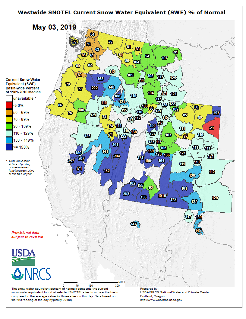
Healthy snowfall from November through April has not only erased the crippling drought across Colorado, but it’s also kept our snowpack at the highest level we’ve seen in two years!
To have every basin in Colorado at 100% or greater for snowpack this late in the Spring is incredible, not only for the ski resorts but for the water supply and the health of Colorado’s forests. 2018’s winter season was so weak, that our snowpack levels are just over DOUBLE what we had last year.
Westwide SNOTEL basin-filled map May 3, 2018 via the NRCS.
…last year the statewide snowpack was roughly half of what is considered a normal level. The worst basins were by far Upper Colorado through the Rio Grande and San Juan, where snowpack levels were worst than 50 percent of the normal level.
Releases from the Aspinall Unit will be increased by 130 cfs on Friday, May 3rd. This will bring flows in the Gunnison River through the Black Canyon up to shoulder flow levels, as described in the decree for the Black Canyon water right. The current forecast for the April-July runoff volume for Blue Mesa Reservoir is 970,000 AF of inflow, which is 144% of average. Flows in the lower Gunnison River are currently above the baseflow target of 1050 cfs. River flows are expected to stay above the baseflow target for the foreseeable future.
Pursuant to the Aspinall Unit Operations Record of Decision (ROD), the baseflow target in the lower Gunnison River, as measured at the Whitewater gage, is 1050 cfs for May.
Currently, diversions into the Gunnison Tunnel are 680 cfs and flows in the Gunnison River through the Black Canyon are around 830 cfs. After this release change Gunnison Tunnel diversions will still be 680 cfs and flows in the Gunnison River through the Black Canyon will be around 960 cfs. Current flow information is obtained from provisional data that may undergo revision subsequent to review.
Here’s the release from Columbia University (Kevin Krajick):
In an unusual new study, scientists say they have detected the fingerprint of human-driven global warming on patterns of drought and moisture across the world as far back as 1900. Rising temperatures are well documented back at least that far, but this is the first time researchers have identified resulting long-term global effects on the water supplies that feed crops and cities. Among the observations, the researchers documented drying of soils across much of populous North America, central America, Eurasia and the Mediterranean. Other areas, including the Indian subcontinent, have become wetter. They say the trends will continue, with severe consequences for humans. The study appears this week in the leading journal Nature.
In general, scientists agree that as global warming progresses, many now dry regions will become drier, and wet ones will become wetter. Some recent studies suggest that human-induced warming has intensified droughts in particular regions, including a now near 20-year ongoing drought in the southwestern United States. However, the last report by the Intergovernmental Panel on Climate Change says confidence in attributing specific ongoing events directly to humans is still chancy.
The new study combines computer models with long-term observations to suggest that systemic changes in what scientists call the hydroclimate are already underway across the world, and have been for some time. The researchers looked not simply at precipitation, but rather soil moisture, a more subtle measure that balances precipitation against evaporation, and is the quality most directly relevant to farming and forestry. They used tree rings going back 600 to 900 years to estimate soil moisture trends before human-produced greenhouse gases started rising, then compared this data with 20th-century tree rings and modern instrumental observations, to see if they could pick out drought patterns matching those predicted by computer models, amid the noise of natural yearly or decadal regional weather variations.
“We asked, does the real world look like what the models tell us to expect?” said study coauthor Benjamin Cook of the NASA Goddard Institute for Space Studies and Columbia University’s Lamont-Doherty Earth Observatory. “The answer is yes. The big thing we learned is that climate change started affecting global patterns of drought in the early 20th century. We expect this pattern to keep emerging as climate change continues.”
Regions projected to become drier or wetter as the world warms. More intense browns mean more aridity; greens, more moisture. (Gray areas lack sufficient data so far.) A new study shows that observations going back to 1900 confirm projections are largely on target. (Adapted from Marvel et al., Nature, 2019)
Lead author Kate Marvel, a climate modeler at Goddard and Columbia University, said, “It’s mind boggling. There is a really clear signal of the effects of human greenhouse gases on the hydroclimate.”
Soil moisture is a complex issue, because precipitation and evaporation can work with each other, or against each other. Warmer air can carry more moisture, and thus more rain or snow. But warmer air can also evaporate more moisture from soil and carry it away, outweighing precipitation. That is probably the factor now at work in the drying western United States, and possibly other locations that have seen recent big droughts. “Precipitation is just the supply side,” said study coauthor Jason Smerdon, a Lamont-Doherty paleoclimatologist. “Temperature is on the demand side, the part that dries things out.” Which part predominates depends on complex factors including wind patterns, seasons, clouds, topography and proximity to the moisture-giving oceans.
The scientists identified three distinct periods in their study. The first was 1900 to 1949, when they say the global-warming fingerprint was the most obvious. During this time, as predicted by models, drying was seen in Australia, much of central America and North America, Europe, the Mediterranean, western Russia and southeast Asia. At the same time, it got wetter in western China, much of central Asia, the Indian subcontinent, Indonesia and central Canada.
From 1950 to 1975, the pattern scattered into seemingly random events. The scientists believe this might be related to enormous amounts of industrial aerosols then being poured into the air without modern pollution controls. These can affect regional cloud formation, rainfall and temperature, by, among other things, blocking solar radiation and providing nuclei for moisture droplets. The researchers believe that the complex effects of aerosols probably threw a monkey wrench into the weather in many places, masking the effects of greenhouse gases, even though those gases continued to rise.
Then, starting in the 1970s, many industrial countries including the United States started instituting progressively stricter clean-air laws. Even though industrial activities continued to grow, aerosols quickly leveled off or slightly declined in many places. But at the same time, greenhouse-gas emissions continued spiraling up, along with temperatures. As a result, the researchers say, the global-warming signature on hydroclimate began re-emerging around 1981. The signal is not yet as obvious as it was in the early 20th century, but it continues to rise, especially since around 2000.
“If we don’t see it coming in stronger in, say, the next 10 years, we might have to wonder whether we are right,” said Marvel. “But all the models are projecting that you should see unprecedented drying soon, in a lot of places.”
Many of the areas expected to dry out are centers of agricultural production, and could become permanently arid. “The human consequences of this, particularly drying over large parts of North America and Eurasia, will likely be severe,” says the study.
Precipitation over much of central America, Mexico the central and western United States and Europe is projected to stay about the same, or even increase. But, according to both the new study and a separate 2018 paper, rising temperatures and resulting evaporation of moisture from soils in those regions will probably predominate. The Mediterranean region is expected to be hit with a double whammy of both less rainfall and more heat-driven evaporation. Adding to the drought dynamics of all the affected areas: populations are expected to continue increasing, adding to water demand. According to an earlier Lamont-Doherty study, a 2006-2010 drought leading up to the disastrous Syrian civil war was probably made more likely by warming climate, and the drought may have helped create the social and economic conditions that sparked the initial rebellion.
Some areas are expected to get wetter, but this may not necessarily be good. India and some surrounding nations are expected to get more rain, because they sit squarely in the path of monsoon winds that pick up moisture from the Pacific and Indian oceans, and those oceans are getting warmer. But the rain may come perhaps more often in overwhelming storms, and not necessarily at times when it is needed.
The new study was made possible in part by recently published atlases of tree-ring chronologies from thousands of sites around the world, going back as far as 2,000 years. These gave the researchers a baseline of how weather varied before humans started heavily affecting it. The atlases are largely the work of Lamont-Doherty scientist Edward Cook, father of study coauthor Benjamin Cook. The North American drought atlas came out in 2004, followed by a Monsoon Asia atlas in 2010, and compilations for Europe and the Mediterranean, Mexico and Australia/New Zealand in 2015. (One for South America is on the way; much of Africa still remains uncovered.)
“This important paper offers new insights into the link between increasing atmospheric greenhouse gases and regional droughts, both in the past and increasingly in the future,” said Peter Gleick, cofounder of California’s Pacific Institute, and expert on climate and water issues. “It also confirms the growing sophistication of our climate models and improves the tools available to detect and identify the fingerprint of human impacts on extreme hydrologic events.”
The study was coauthored also by Céline Bonfils and Paul Durack of Lawrence Livermore National Laboratory, and A. Park Williams of Lamont-Doherty.
Here’s a report from National Geographic. Click through and read the whole thing. Here’s an excerpt:
Using studies of tree rings going back centuries, scientists have unearthed clear evidence that the rise of human-generated greenhouse gases was having an effect on global drought conditions as early as 1900.
A new, first-of-its-kind study by scientists at Columbia University’s Earth Institute, published Wednesday in the journal Nature, largely confirms what climate models have shown. In the absence of strong historic data on precipitation, those computer models forecast not only future scenarios, but shed light on historical trends.
The dovetailing of the tree-ring studies, which correlate to soil moisture, with climate models gives scientists the assurance that the computer models are, in fact, correct, they say.
“These tree-ring reconstructions let us go back in time and get a picture of global drought conditions for hundreds of years before the Industrial Revolution,” said Kate Marvel, an associate research scientist at the Earth Institute and NASA’s Goddard Institute for Space Studies and the lead author of the study.
CSU junior Brad Simms gets to work with his shovel in efforts to restore the area around Left Hand Canyon from the floods. Brad is a member of CSU’s Watershed club. (Jenna Van Lone | Collegian)
The St. Vrain Left Hand Conservancy District, whose mission is to protect water rights and improve management practices in the river basin, is in the first phase of developing a stream management plan for the 300,000-acre watershed. Its goal is to align strategies for maintaining the reliable delivery of water to agricultural users while also satisfying ecological and recreational goals, some of which could require higher flows in the main stretches of streams that feed the St. Vrain, such as Left Hand Creek, as well as the St. Vrain itself, which is a key South Platte River tributary.
“Whether you’re a domestic or agricultural water user, you have an opportunity to really be part of a strategic, balanced approach to meeting competing demands,” said Sean Cronin, the district’s executive director.
But Colorado water law is focused on the use of the state’s most valuable resource, and not on conservation, notes a September survey prepared by a firm hired by the conservancy district for the stream management plan.
“This causes water owners to shy away from change of use, dam modifications or other river improvements, fearing legal or financial challenges and a burden on their time — and farmers do not have time to give away,” the survey states, adding it also will be a challenge to have rights owners “‘open up’ about their decrees or the way they manage, use or store water, and there are sometimes long histories of relationships between agencies or people in how they work together with their water. Overcoming some of these social and political legacies, or positively using these relationships, will be a challenge to the process.”
Seeking balance at what cost?
Diverting water from stream beds through ditch delivery networks has long quenched otherwise dry agricultural lands on the Front Range, but the expansion of the practice over time has led to impacts some are now interested in mitigating.
Boosting the ability for fish and recreational users such as kayakers to pass diversions by altering or replacing infrastructural barriers has consistently been expressed as a priority.
So have improved ability to control timing and quantity of both ditch and stream bed flows, enhancing flood resiliency in the watershed and preventing impacts from municipal development.
“For the most part, this basin wants to work toward finding that balance,” Cronin said. “I won’t say we’re all in agreement of what the balance is, where that pivotal point is to make the balance, and I don’t think we’ll ever get there and that’s fine, as long as folks want to continue sitting at the table.”
While some Longmont-area ditch companies have already designed and implemented more passable diversions or are in talks with local officials about doing so in the near future, a move toward automating the opening and closing of ditch gates that are now moved manually to accommodate water share holders’ calls for supply also could emerge as a consideration for those relying on the watershed.
Being able to remotely open and close gates could help prevent flow heading into ditches when it isn’t needed, possibly allowing higher flows in main stream beds through areas where such water levels could benefit recreation and environmental health.
But doing so could come at a major cost. Terry Plummer, vice president of maintenance and operations for Left Hand Ditch Co., said the company, for reasons unrelated to stream management, next week will install an automated ditch gate that can be operated remotely in one location on its network at a cost of about $30,000.
If an effort to automate water delivery equipment were applied across the broader watershed, though, it would be needed in dozens of locations, and could require the construction of entirely new diversion structures in some areas, which can run cost hundreds of thousands for just one spot, Plummer said.
“We have no intentions of automating at this point in time,” Plummer said. “It’s just too expensive. The assessments (charged to share holders for ditch maintenance) are so high now because of the 2013 flood (damage) that we would have to raise assessments dramatically, and the farming can’t support that.”
He said grant funding would have to become available, with the right terms, to pursue widespread automation.
A method that helped maintain higher wintertime flows in the St. Vrain is likely no longer an option — for about 20 years until 2013, Longmont released water from its Ralph Price Reservoir storage at a rate of 3 cubic feet per second to maintain a winter flow of 5 cfs along the entirety of the river, according to city Water Resources Manager Ken Huson.
But state officials nixed that practice after changing how they account for water.
“It’s not something Longmont can just do on its own anymore like we used to,” Huson said.
Flow not only way to go
Other opportunities for bettering stream management in the St. Vrain watershed might not address flow, however, and still offer environmental and social benefits.
“What we’re going to come up with are management activities,” Cronin said. “Those could address flow, but it could be that an opportunity area doesn’t necessarily have a flow challenge, but a riparian floodplain connectivity challenge.”
Allowing streams to more easily access the floodplain by preventing their banks from becoming overly incised or congested can help avoid rushing waters during flood events via letting the excess flow spread out over flatland, instead of accumulating in steep, deep channels.
Removing the invasive crack willow tree, which has problematically proliferated across dozens of states, from local stream banks could help achieve that, and has already been worked on in some areas of the St. Vrain basin by the Left Hand Watershed Oversight Group.
“That’s really the issue with the current conditions and why there are disconnected floodplains, because we’ve had this encroachment of this invasive tree that has created a super stable bank, and has allowed incision to happen,” said Jessie Olson, the oversight group’s executive director. “We’ve got a number of places like that throughout the watershed that could use some additional connectivity basically by removing the invasive tree and laying back slopes.”
With a cursory stop in the Colorado House, the state Climate Action Plan should be on its way to the governor’s desk to become official policy.
The state Senate passed House Bill 19-1261 with an 18-16 party-line vote Wednesday, sending the bill back to the lower chamber to approve the upper chamber’s amendments.
Senators early Tuesday morning tweaked the language in the bill to address disproportionately impacted communities, as well as to grant more credit for technology that reduces emissions, and to instruct regulators to consider how new rules impact electricity reliability.
Republicans continued to warn that the goals to reduce greenhouse gas emissions would cost the state’s economy and residents at levels that aren’t known…
The bill says the state should create policies that reduce emissions by at least 26% by 2025, at least 50% by 2030 and 90% by 2050, based on 2005 levels.
The state Air Quality Control Commission would be tasked with creating unspecified rules to help the state meet those goals…
With just two days left in the session, the bill will be a high priority when it returns to the House, where it was introduced by House Speaker KC Becker, D-Boulder, on March 21…
“Our state is on the front lines of climate change and Coloradans agree we must act,” Kelly Nordini, executive director of Conservation Colorado, the state’s largest environmental organization, said in a statement Wednesday.
“Thank you to our state senators who prioritized climate action today and voted to pass HB 19-1261, the Climate Action Plan.”
House Bill 1261, which would set a series of statewide targets for reducing greenhouse gas emissions over the next few decades, passed the Senate on a party-line vote on Wednesday, May 1. Hours later, the House, which had given its initial approval to the bill last month, re-passed the bill with Senate amendments, sending it to Governor Jared Polis to be signed into law.
“Make no mistake: This is a big deal,” Kelly Nordini, executive director of Conservation Colorado, said in a statement on the bill’s passage. “The Climate Action Plan to Reduce Pollution ensures that we are doing our part to reduce carbon pollution and leave a livable, healthy Colorado to our kids and grandkids.”
HB 1261 would commit the state to achieving a 26 percent cut in carbon emissions by 2025 — formalizing a goal set by former governor John Hickenlooper in a 2017 executive order — as well as a 50 percent cut by 2030 and a 90 percent cut by 2050. That’s roughly in line with the global decarbonization timeline suggested by top U.N. climate scientists in a major report last year.
Some environmental activists, however, argue that Colorado should set even more ambitious goals. Many theoretical models for rapid global decarbonization require the U.S. and Europe to achieve net-zero emissions much faster than developing Asian and African countries — and in general, the more aggressive the timeline, the better the odds of staying below dangerous warming thresholds.
In a statement on HB 1261’s passage, the Colorado Coalition for a Livable Climate, which includes more than two dozen environmental and social-justice groups, applauded the “historic progress” made by the bill but urged Democratic lawmakers to do more when they return to the Capitol next year.
“The CCLC calls on the legislature to improve upon the goals established by HB19-1261 in 2020 so that they are more in line with what the science is telling us we must do,” the statement read. “Our state must adjust its goals in accordance with the best available science to establish Colorado as a true climate leader, for the sake of ourselves and future generations.”
Lawmakers on Wednesday also gave final approval to Senate Bill 77, bipartisan legislation that incentivizes electric utilities to build charging ports and other infrastructure for electric vehicles. After electricity generation, transportation is Colorado’s second-largest source of carbon emissions, and the widespread adoption of zero-emission EVs is a crucial strategy for achieving the necessary cuts. Officials have committed to putting nearly one million EVs on Colorado roads by 2030, or roughly 15 percent of all light-duty vehicles in the state.
“[SB 77] is really important, because in order to hit Colorado’s electric-vehicle goals, we’re going to need to build thousands of charging stations in lots of different places,” says Travis Madsen, director of the transportation program at the Southwest Energy Efficiency Project. “And our electric utility companies are well-positioned to do a lot of that work. It’s an essential step in getting rid of the pollution from our vehicle system.”
As the clock runs down on the legislature’s 120-day regular session, a backlog of roughly 200 bills remains on the official legislative calendar, and Republicans are doing everything they can to slow down floor work. While Democrats prioritized HB 1261 and SB 77 for passage, many other significant pieces of legislation are at risk of not being passed, including several related to climate policy…
Also awaiting Senate action is House Bill 1159, which would extend state tax credits for electric-vehicle purchases. House Bill 1313, which would codify and provide incentives for Xcel Energy’s plan to achieve an 80 percent carbon emissions cut from electricity generation by 2030, advanced out of a Senate committee on Wednesday night and will need to clear another committee and two votes of the full Senate before midnight Friday.
Advocates for climate action are hopeful that the remaining bills will get in under the wire and confident that the legislature’s work this session will mark a turning point for Colorado’s efforts to cut emissions…
In last year’s landmark report, U.N. scientists told the world’s policymakers that achieving a 45 percent emissions cut by 2030 would require “rapid, far-reaching and unprecedented changes in all aspects of society.” Once Polis signs HB 1261 into law, Colorado will be formally committed to making such changes. A long rule-making and implementation process will follow, and only time will tell how effective the new law really is. But the stakes, as activists noted following the bill’s passage on Wednesday, couldn’t be higher.
“The risk that climate change will destroy all we hold dear is readily apparent now,” Gina Hardin, president of climate activist group 350 Colorado, said in the CCLC’s statement. “The Midwest may take centuries to recover from the massive loss of topsoil from the unprecedented flooding in what has been the world’s breadbasket. The damage has already cost $3 billion and is rising. Recovery from the infrastructure and economic destruction will take years. Mozambique has just been slammed by an unprecedented two cyclones within 6 weeks. The horror stories go on and on.”
FromThe Grand Junction Daily Sentinel (Dennis Webb):
The filings by Fram Operating and its owner, Fram Americas, both of Colorado Springs, means that the companies go out of business and nonexempt property is liquidated and the proceeds distributed to creditors. Fram Americas is owned by Fram Exploration AS in Norway.
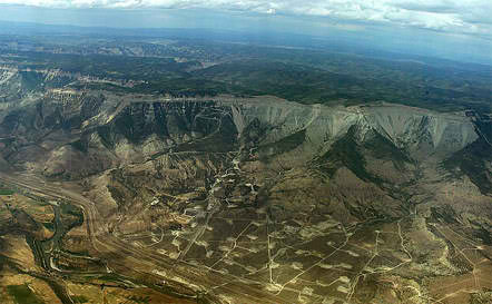
In March 2018, the Bureau of Land Management approved Fram’s Whitewater Unit Master Development Plan, under which it hoped to drill 108 wells from 12 pads 15 miles southeast of Grand Junction. The BLM had estimated the project could result in production of 8.7 million barrels of oil over 20 years.
The project was supported in some quarters due to the jobs, tax revenues and other economic benefits that could result, but opposed by activists groups and others due to concerns about potential air, water, traffic and other impacts.
Fram’s bankruptcy could mean the end of the project unless it can be sold during the liquidation process. Kenneth Buechler, the attorney representing Fram in the bankruptcy proceedings, said bankruptcy law generally provides that contractual rights existing at the time of bankruptcy become property of the bankruptcy estate, and another asset the trustee in the case potentially could sell. But he said he didn’t know if there would be restrictions on any possible sale of the Fram project or items that need to be cured, such as when it comes to the pertinent oil and gas leases.
“This (bankruptcy) isn’t surprising to us at all,” said Emily Hornback, staff director of the Western Colorado Alliance activist group.
She said opponents of the Whitewater project have been raising questions for years about the financial solvency of Fram. She said it’s fortunate Fram’s financial situation came to light before work proceeded on the project, so the public isn’t left holding the bag on cleanup costs.