Public scoping begins for Browns Canyon National Monument resource management plan, comments end June 13, 2019

Browns Canyon via BrownsCanyon.org

From Bureau of Land Management:

On May 14, 2019, the BLM and the U.S. Forest Service (USFS) published in the Federal Register a notice of intent (NOI) to prepare a Resource Management Plan/Environmental Impact Statement (RMP/EIS) for Browns Canyon National Monument (BCNM).

The BLM and USFS are soliciting comments from the public about issues to be addressed in the BCNM RMP/EIS, such as wild and scenic river values (see Issues in the navigation list on the left) and those described in the Planning Criteria Report (see Documents & Reports in the navigation list).

Comments can be submitted online through the interactive mapping tool here: http://arcg.is/1yuDDD, through the Documents & Reports page, or by U.S. Mail to BCNM RMP/EIS, 5575 Cleora Road, Salida, CO 81201. Please do not email comments.

Written comments must be received by June 13, 2019, in order to receive a formal response in a scoping comment report, which will be released at a later date.

For a schedule of public scoping meetings, see “Meetings” under the How to get Involved link at left.

HOW TO COMMENT:

The most useful comments are specific comments about BCNM management issues, goals, and objectives. The BLM and USFS are especially interested in comments on the preliminary alternatives and basis for analysis found in the Planning Criteria Report (see Documents & Reports page) and comments on wild and scenic river values (see the Issues page).

Effective comments provide constructive solutions, specific examples, and supporting documentation; are clear, concise, and relevant; and avoid simply stating an opinion.

The BLM and USFS will review comments submitted during the scoping period and respond to them in a scoping comment report to be published at a later date. Comments submitted outside of this period will be considered but won’t be in the scoping report.

Before including your address, phone number, email address, or other personal identifying information in your comment, be advised that your entire comment, including your personal identifying information, may be made publicly available at any time. While you can ask us in your comment to withhold your personal identifying information from public review, we cannot guarantee that we will be able to do so.

What Does the #ColoradoRiver #Drought Plan Mean for #California? — Public Policy Institute of California #DCP #COriver #aridification

From the Public Policy Institute of California (Gokce Sencan):

A much-anticipated plan to address chronic water shortages in the Colorado River Basin was recently signed into law by President Trump. This drought contingency plan (DCP) aims to slow the long-term decline in Lake Mead’s water levels caused by over-allocation of Colorado River water and 19 years of drought, as well as address future water shortages in the basin.

The DCP is the fruit of a decade of negotiations among the seven basin states to resolve the over-allocation problem through cuts and water storage. (Mexico receives water from the river but is not part of this plan.) California has the largest share of the Colorado, with senior rights to more than a quarter of the river’s average annual flow.

Graphic credit: The Public Policy Institute of California

Lake Mead is a water source for 600,000 acres of farmland and 19 million people in Southern California. California agencies can also store up to 250,000 acre-feet of water in Lake Mead.

Without the DCP, Lake Mead’s water level could drop too low to allow releases from Hoover Dam. As the lake nears this threshold, senior water right-holders in California might be tempted to withdraw their water before it becomes inaccessible. While such a move would be permissible, it would accelerate the drop in the lake level and affect future deliveries for junior water right-holders in the other lower-basin states.

The DCP eliminates this concern and delivers an orderly and mutually agreed upon method to manage shortages until 2026. It provides assurance against curtailments for water stored behind the dam. This is especially important for the Southern California water agencies, whose ability to store water in Lake Mead is crucial for managing seasonal demands.

Some significant challenges must still be addressed, however. The Imperial Irrigation District, the largest Colorado River water user, opted out of the plan due to a dispute over funding to restore the shrinking Salton Sea. The district also filed a lawsuit that calls for the DCP to be suspended until an environmental review of the plan is completed.

The lawsuit alleges that the Metropolitan Water District (MWD), which would contribute most of the water required to fulfill California’s obligations under the DCP in times of system-wide shortage, unlawfully approved the DCP. IID claims that MWD did not consider the “sources of water that would be necessary for [it] to fulfill its commitment and the environmental effects associated with obtaining water for those sources.” The outcome of this lawsuit is uncertain.

Currently, the Colorado supplies about a third of all water used in Southern California’s urban areas. The region’s water agencies are taking steps to develop more local supplies and increase water efficiency to help them meet water demand if DCP cuts are triggered during a future water shortage.

The plan won’t cause immediate water cuts. This year’s wet winter means that Lake Mead’s elevation, currently 1,090 feet above sea level, may remain above the 1,045-foot threshold at which the mandate is triggered for California. But the basin states now have a plan in place to address the next dry spell.

Graphic credit: Public Policy Institute of California

#Snowpack news: Snowmelt Processes Infographic via @NOAA

With the monster snowpack across Colorado it’s time to review snowmelt processes. Here’s an infographic from NOAA.

The Metro Wastewater Reclamation District honored 19 metro area organizations for perfect compliance with their industrial wastewater discharge permits on May 8, 2019

Here’s the release from the Metro Wastewater Reclamation District (Kelly Merritt):

The Metro Wastewater Reclamation District (Metro District) honored 19 metro area organizations for perfect compliance with their industrial wastewater discharge permits on May 8, 2019. Water Remediation Technology, LLC, received a Platinum Award for perfect compliance for five consecutive years (2014 through 2018).

The following were recognized with Gold Awards for perfect compliance from January through December 2018:

 Acme Manufacturing Company, Inc.
 Advanced Circuits, Inc.
 Ball Metal Beverage Container Corp.
 CoorsTek, Inc.
 CW Elaborations, Inc.
 Denver Metal Finishing
 G & K Services, A Division of Cintas
 Industrialex Manufacturing Corp.
 Majestic Metals, LLC
 Packaging Corporation of America
 Pepsi Beverages Company
 RMO, Inc.
 Rocky Mountain Bottle Company, LLC
 Safeway, Inc., Denver Beverage Plant
 Swire Coca-Cola, USA
 United States Mint
 Upsher-Smith Laboratories, LLC
 Wanco, Inc.

The federal Pretreatment Regulations under the Clean Water Act require the Metro District to have an Industrial Pretreatment Program to control the discharge of industrial wastes to the sanitary sewer system. One of the ways that the Metro District controls these discharges is through issuance of industrial wastewater discharge permits.

Metropolitan Wastewater Reclamation District Hite plant outfall via South Platte Coalition for Urban River Evaluation

@USGS explainer, “Base Flow in Rivers”

Click here to go to the USGS website. Here’s an excerpt:

When a drought hits and little or no rain has fallen in a long time, you might expect small streams and even larger rivers to just dry up, right? In many cases, they don’t. Streamflow might lessen to a trickle or so, but water continues to flow. How is that possible? Read on to find out how “base flow”, which is water seeping into the stream from groundwater, helps keep water in streams during droughts.

Groundwater movement via the USGS

@ColoradoClimate: Weekly Climate, Water and #Drought Assessment of the Intermountain West

Click here to read the current assessment. Click here to go to the NIDIS website hosted by the Colorado Climate Center.

2019 #COleg: Kerry Donovan recaps the session

From The Ark Valley Voice (Kerry Donovan):

Climate Data Bill (SB19-096)

With the growing concerns about the impact of climate on our economy, I passed a bill to collect long term climate data for the state so that we can work to create solutions that are informed by Colorado-specific data.

Water Bills: (SB19-186, SB19-221, HB19-1113)

Water is a critical part of Colorado’s businesses and way of life, which is is why I carried SB19-186, SB19-221 and HB19-1113 to protect water from adverse mining impacts, to take a step towards funding the critical water projects the Western Slope has prioritized, and to broaden the scope of agriculture’s role in water quality.

Acid mine drainage Pennsylvania Mine via the Summit County Citizens Voice

#Snowpack news: The beautiful snowpack pretty much ended the 2018 #drought in #Colorado @ColoradoClimate @CWCB_DNR

From The Colorado Springs Gazette (Liz Forster):

…reservoirs are filling, and the generous snowfall has nearly eliminated a drought that hydrologists said in January would take years for recovery.

“I don’t see how you could order something better than what we got after a year like last,” said Greg Smith, a senior hydrologist with the National Oceanic and Atmospheric Administration. “This is exactly what we needed.”

[…]

…this March was the third wettest in the Upper San Juan River Basin, with about 14.1 inches of snow water equivalent, Smith said. The record was set in 1979 with 17.3 inches, and the average is 6.1 inches…

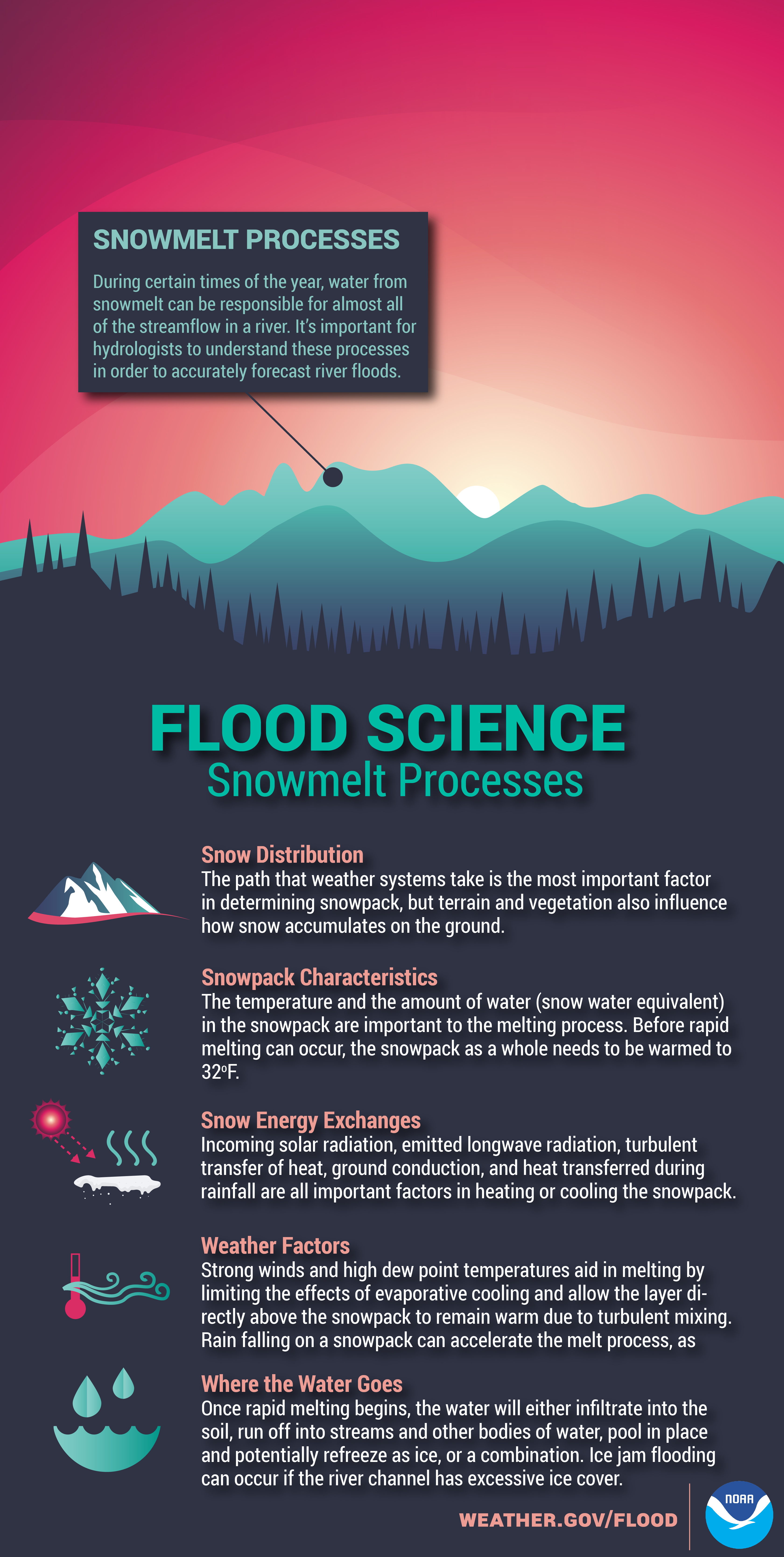
Colorado’s snow water equivalent dropped below its median peak of 16.8 inches for the first time April 28, 18 days later than usual. (The median is the midpoint between the highest and lowest.) But a storm at the end of April boosted the snowpack above peak — and the snow hasn’t stopped. Flakes fell again last week across the state, though not enough to surpass the median apex again.

The contrast in Colorado snow levels year to year are remarkable at 15.4 inches versus 4.

Encouraging conditions are widespread in the Upper Colorado River Basin and across the Southwest, Smith said…

“Even in areas like the Yampa and Green rivers, which were running a bit below average to start, they caught up in the second half of spring,” he said.

The drought that ushered in severe wildfires and dismally low reservoir levels is almost history, with about 84% of the state sated, according to the U.S. Drought Monitor, compared with 82% in need of a soak one year ago.

Since the U.S. Drought Monitor was established in 1999, the state always had some abnormally dry areas. Now, only 15.28% of the state is abnormally dry, and less than 1% is in a moderate drought…

Becky Bolinger, a climatologist with the Colorado Climate Center, said the state needed enough snow to fill three “buckets”: soil, rivers and streams, and reservoirs.

“When the snowpack first started to accumulate, we thought, ‘This is good, but will it be good enough to really recover the entire hydrological system?’ But once the snow and cold came in February and March, it became more likely that we could see recovery in all of those buckets,” Bolinger said.

Besides cooler, wetter conditions throughout the Southwest, the wind has blown in less dust, which can accelerate melting because of its darker color, a measurement known as albedo.

So far this year, three events have blown dust onto the 11 mountain passes tracked by the Colorado Center for Snow and Avalanche. By May 14, 2018, the research institute had reported eight.

“Our melt rate is going steady, and there’s nothing too much to be concerned about,” said Russ Schumacher, state climatologist and director of the Colorado Climate Center.

The wet, cool cycle appears to be continuing into late spring and summer, forecasts show. NOAA predicted a 50% chance of above average precipitation for most of Colorado through July, average temperatures for central Colorado, below average for the eastern plains and slightly above average on the Western Slope.

From The Denver Post (Chris Bianchi):

The key as far as possible stream and river flooding, though, is just how quickly that snow will melt. If temperatures quickly spike, for example, rivers and streams could be quickly overwhelmed by a sudden influx of high water.

“The mountains have been getting snow and they’re going to get more (this week),” said Jim Kalina, a meteorologist with the National Weather Service office in Boulder. “The first concern for flooding would be from the melting snowpack. If the pattern changes and we suddenly get warm, that’s probably the biggest concern for the rivers. There’s a potential since we have such a high snowpack.”

Of course, the melting snow will provide a huge positive boost to Colorado in the form of valuable water for state reservoirs. At the end of April, statewide reservoirs were running at 90 percent of average. That said, the lowest reservoir capacity levels were mainly in the southwestern part of the state, and that’s where the most snow remains to melt. The melting snow will likely help fill reservoirs that were largely depleted by last year’s drought…

…long-range outlooks produced by the Climate Prediction Center (CPC), which cites a familiar culprit for the wetter than average long-range outlook: El Nino. There are a number of factors in play, but the key is the continued presence of a weak El Nino pattern in the tropical Pacific Ocean. The meteorological domino effect of warmer-than-average central Pacific waters influences global weather, including an influx of energy into the United States’ subtropical jet stream. While it’s not always the case, that El Nino-driven boost of jet stream energy can often translate to extra moisture along the Front Range.

“Typically, El Nino leads to a bit of wetter years over our area here in eastern Colorado,” Kalina said. “There seems to be a bit more moisture available. There seems to be more fuel for added precipitation.”

While the effect of soil moisture on summer showers and storms isn’t entirely clear, there is also a possible natural link between added snow levels and increased rainfall. In short, melting snow increases the amount of water in the ground, and that water has to evaporate. That evaporated water can add moisture to the air, therefore increasing chances for afternoon showers and storms…

Summer and fall rain, however, typically comes from a different source: the annual monsoon. The monsoon is a seasonal reversal of typical wind patterns, leading to extra showers and thunderstorms for the southwestern United States. This usually starts to flare up in July, with August and early September the typical prime time for monsoonal moisture. While Denver and most of the Front Range is typically tends to feel only fringe impacts from the monsoon, showers and storms generated by the monsoon can lead to extra rain and storms.

Predicting the monsoon’s strength and precise impacts, however, is a bit of a shot in the dark.

“The main thing is the monsoon sets up. It’s really difficult to predict that,” Kalina said. “Some years you have a weak monsoon, sometimes you have a strong one. It all depends on where it sets up and how strong it is.”

At least in the near term, chances are overall trending toward a wet late spring, summer and early fall. And in case you’ve been stuck in a windowless basement the last few weeks, it’s been a wet start to May, with more moisture likely en route this week and next.

From The Mohave Daily News (Saul A. Flores):

According to the BOR, the snowpack in the Upper Basin is nearly 140% above average as of April 15 and it forecasts that seasonal inflow to Lake Powell will be at 128% of average.

“We are pleased to see the above average snowpack conditions in the Upper Basin and the improvement in the inflow forecast for Lake Powell,” said Brent Rhees, BOR’s Upper Colorado regional director. “Significant risks and uncertainty persist and storage at Lake Powell remains essential to the overall well being of the basin.”

The BOR, based on April’s 24-month study, projected Lake Powell to release up to 9 million acre-feet in water year 2019. Lake Powell’s elevation at the end of the calendar year is projected to be 3,607.49 feet above sea level.

“These developments may lessen the chance of shortage in 2020,” Terry Fulp, BOR’s Lower Colorado regional director, said in a prepared statement. “However, one near or even above average year will not end the ongoing extended drought experienced in the Colorado River Basin and does not substantially reduce the risks facing the basin.”

In the same 24-month study, the BOR stated that Lake Mead’s elevation at the end of the 2019 calendar year is projected to be at 1,084.72 feet above sea level, nearly 10 feet above the shortage determination trigger of 1,075 feet.

The BOR said that operating tiers for Lake Powell in the water year 2020 and operating condition for Lake Mead in the calendar year 2020 will be determined based on the projected conditions on Jan. 1, 2020, as reported in this coming August’s 24-month study.

#ColoradoRiver: 2019 State of the River meeting recap: “The long-term trend is that it’s drier” — Hannah Holm #COriver #aridification

Changing nature of Colorado River droughts, Udall/Overpeck 2017.

From The Grand Junction Daily Sentinel (Katie Langford):

Despite plentiful snowfall this winter and a rainy spring on the Western Slope, local water experts took a cautious tone at the 2019 State of the River meeting Tuesday night.

Snowpacks and inflow at reservoirs across the state are well above average, but that isn’t necessarily an indicator for the future, said Erik Knight, a hydrologist with the U.S. Bureau of Reclamation.

There have been multiple examples of precipitation swinging from very dry to very wet and back again the next year, Knight said…

Hannah Holm, coordinator for the Hutchins Water Center at Colorado Mesa University, said while a wet year can give water users a break, it doesn’t change trends.

“The long-term trend is that it’s drier,” Holm said. “The overall precipitation trend is flat, but because of increased temperatures over that same time frame, the amount of water in the river is going down.”

Water users like towns and cities, farmers and the recreation industry are still collaborating on a solution for the problem of less water to go around, Holm said.