Here’s the release from the Southeastern Colorado Water Conservancy District (Chris Woodka):
Agriculture received the lion’s share of water from the Fryingpan-Arkansas Project this year, when an abundant water supply is expected to boost Arkansas River flows as well as imported water.
Allocations totaling 63,000 acre-feet were made by the Southeastern Colorado Water Conservancy District board on Thursday (May 16), with 48,668 acre-feet going to agriculture, and 14,332 going to cities. The district is the agency responsible for management of the Fry-Ark Project, which is operated by the U.S. Bureau of Reclamation.
“This is a remarkable outcome for the Arkansas River basin, given the dry conditions we faced last year,” said Garrett Markus, water resources engineer for the district. “The conditions look favorable during the next three months, when rainfall should add to the abundant snowpack already in the mountains.”
Water users in nine counties benefit from the supplemental water provided by the Fry-Ark Project, ranging from large cities in Pueblo and El Paso counties to irrigation companies in the Lower Arkansas Valley. Fry-Ark Project water accounts for about 10 percent of flows in the Arkansas River annually.
While cities are entitled to more than 54 percent of project water, their accounts in Pueblo Reservoir are relatively full, freeing up additional water for agriculture. Municipal allocations include:
Fountain Valley Authority, 7,353 acre-feet;
Pueblo Water, 2,000 acre-feet;
Cities west of Pueblo, 2,312 acre-feet;
Cities east of Pueblo, 2,667 acre-feet.
In the event of changing conditions – a reduction of precipitation or rapid melt-off of snow – the District initially will release only 28,256 acre-feet of water to irrigation companies until final imports are certain, with the remainder delivered as soon as the expected total is reached. Municipal allocations would not be affected by a shortfall, because they are all below allocation limits.
Another 17,338 acre-feet of irrigation return flows were allocation, and 10,016 acre-feet will be initially released.
Reclamation estimates the project will yield 84,000 acre-feet this year, but deductions from that total are made for evaporation, transit loss and obligations to other water users reduce the amount of water available to allocate.
The Fry-Ark Project imports an average of about 56,000 acre-feet through its collection system in the Fryingpan River and Hunter Creek watersheds above Basalt. Water comes through the Boustead Tunnel into Turquoise Lake, through the Mount Elbert Power Plant at Twin Lakes and into terminal storage at Pueblo Reservoir.
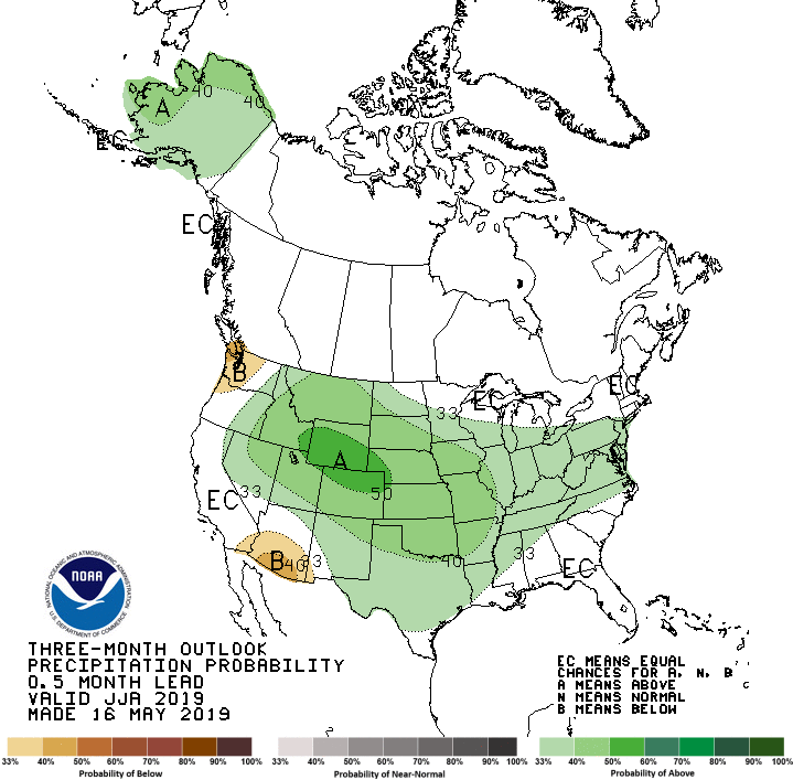
Three-month projections from the National Oceanic and Atmospheric Administration predict cooler and wetter than average conditions for eastern Colorado.
The outflow of the Bousted Tunnel just above Turquoise Reservoir near Leadville. The tunnel moves water from tributaries of the Roaring Fork and Fryingpan rivers under the Continental Divide for use by Front Range cities, and Pitkin County officials have concerns that more water will someday be sent through it.
Boustead Tunnel Construction via The Aspen Times
The end of the tunnel that brings water from Hunter Creek to the Fryingpan River drainage, and then on to the eastern slope. Photo credit: Brent Gardner-Smith, Aspen Journalism.
A portion of the flow in Hunter Creek is diverted to the Front Range and to locations downvalley from Aspen.
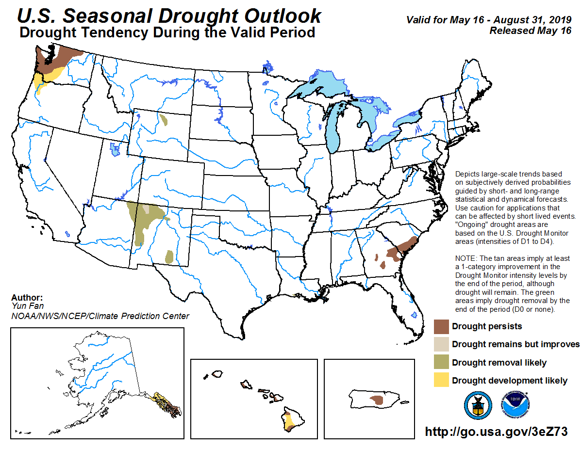
As the snowpack runoff season begins, Colorado’s drought situation has dramatically improved again. In the past three months, the areas on the drought map marked abnormally dry or worse have shrunk by 88%.
On Feb. 12, 92% of the state was under some kind of drought status, including the most severe “exceptional drought” rating. On Thursday, the U.S. Drought Monitor reported that just 11% of Colorado is abnormally dry, but that no area is under a “drought” listing…
Colorado Drought Monitor May 16, 2019.
Colorado Drought Monitor February 12, 2019.
But [Cari Bowen] cautioned that things could change if there are a few weeks of dry weather.
“It’s all kind of pattern based,” she said. “Drought is not always something that’s fixed in the short term. It’s a long-term thing.”
That being said, early signs are pointing to some big improvements.
Reservoir storage levels in much of the state, which were giving farmers heartburn last summer, are looking solid. Only reservoirs in the southwest corner of Colorado remain far below their average levels, holding just a sliver of their capacity.
Statewide, reservoirs are at 90% of their average fill level and holding 53% of their capacity. Compared to last year’s average, reservoirs at are 111%…
Bowen said the late storms and relatively cool temperatures in the high country have helped keep the runoff season from ramping up too quickly to be captured.
“That definitely does push back that melting a little bit,” she said.
Can the City of Moab take water out of the Colorado River if its springs and wells become depleted? Is climate change data being factored into water use planning in Moab and in the State of Utah?
These were two questions raised on Tuesday, May 14, at the Moab City Council workshop discussing an assessment and recent report detailing surface and groundwater resources in and around Moab.
Moab City Engineer Chuck Williams delivered the hour-long workshop presentation along with the authors of the report, Kenneth Kolm and Paul K.M. van der Heijde. Kolm works at Hydrologic Systems Analysis LLC in Golden, Colorado, while van der Heijde works at Heath Hydrology Inc. based in Boulder, Colorado.
The report contains a three-phase plan for Moab’s springs and wells. The first phase, to use mapping and data to perform a Hydrologic and Environmental System Analysis (HESA) of Moab’s springs and wells to develop a comprehensive and updated understanding of the groundwater system, has been completed. The second phase, collecting hyrodological and hydrogeological data currently available to use in a water budget, has also been completed.
The third phase, which has not yet been completed, aims to update the Water Protections Plans for the city’s springs and wells.
The city’s plans are not the same as the Groundwater Management Plan currently under development, and spearheaded by, the Utah Department of Natural Resources Division of Water Rights for Moab and Spanish Valley. The report presented at the workshop explained surface water and groundwater flows and how the geologic rock formations influence the flow, storage, distribution of water, and did not talk about water rights.
However, the city’s data from the assessment and its plans will be considered in the development of the Groundwater Management Plan, said Marc Stilson, the southeastern regional engineer for the Division of Water Rights, along with data from his agency’s work on water rights adjudication in the valley and a recent U.S. Geological Survey (USGS) study.
Moab City Council member Rani Derasary asked during the workshop if climate change data is reflected in the assessment and planning.
“In terms of climate change, is there a standard, either percentage or formula, that, if you wanted a community to plan out 40 years, does the state allow you to calculate that in?” Derasary asked. “Is that all based on the engineer calculating anyway, then it would be based on consultation from a hydrologist on how you should help calculate that? Just cause it seems like that’s something we’re facing. I don’t know how it’s going to affect these numbers.”
Van der Heijde responded by saying that climate change data has not been included and explained that a change would mean either more snow and precipitation or less, which would create a “major change” in the use of water by plants and the in-flow of water from Mill Creek from the La Sal Mountains.
“I would say in this right now, we don’t have it,” he said. we didn’t locate it right now, because there was not this question,” he said. “If you are concerned for a 40-year plan, I think that there are already studies that give some indication for this area … not certain what those predictions are, we (have not) looked into that… I’m not certain where to find it, but it is possible.”
Ed Quillen used to say that oil shale had been the, “Next big thing for 100 years.”
Here’s the release from the Southern Utah Wilderness Alliance (Ray Bloxham) via Earth Justice:
Conservation groups today sued the Trump administration to challenge what would be the nation’s first commercial-scale oil shale mine and processing facility. The lawsuit says officials failed to protect several endangered species when they approved rights-of-way across public lands to provide utilities to the proposed oil shale development.
The massive Enefit project in northeast Utah’s Uintah Basin would also drain billions of gallons of water from the Green River, generate enormous amounts of greenhouse gas pollution and exacerbate the Uintah Basin’s often-dismal air quality.
Today’s lawsuit, filed in U.S. District Court in Utah, argues that the U.S. Fish and Wildlife Service violated the law by ignoring the potential harm to endangered fish. In its biological opinion, the agency considered only the harm from water depletions necessary to build the pipeline, not the billions of gallons of Green River water that will be sent through the pipeline to Enefit’s oil shale development.
“The responsible federal agencies have worn blinders in approving this project, leaving themselves and the public in the dark about the immense ecological harm it would cause,” said Alex Hardee, attorney at Earthjustice. “We’re going to court to uphold the nation’s environmental laws and save the Upper Colorado River Basin from the devastating effects of oil shale.”
The Bureau of Land Management also violated the law by failing to adequately analyze the significant environmental impacts of the proposed oil shale development, which likely would not occur but for the agency’s approval of the rights-of-way.
“This is a prescription for disaster for our climate, wildlife, and the Colorado River Basin,” said Ted Zukoski, a senior attorney at the Center for Biological Diversity. “Draining the Green River to mine one of the most carbon-intensive fuels on the planet sends us in exactly the wrong direction. It’s putting us on a collision course with climate catastrophe so a foreign fossil-fuel company can make big bucks.”
The Trump administration paved the way for the project last year by approving rights-of-way for electricity, oil, gas, and water lines across public lands. At full buildout, the Estonian-owned Enefit American Oil facility would produce 50,000 barrels of oil every day for the next 30 years or more from the Green River Formation.
Map of oil shale and tar sands in Colorado, Utah and Wyoming — via the BLM
“The environmental destruction, air pollution and water pollution inherent in this proposed oil shale mining project is something that every citizen of Utah should be alarmed about,” said Dr. Brian Moench, president and founder of Utah Physicians for a Healthy Environment. “That it would become a long-term public health disaster is being callously dismissed by a BLM that is being run as a subsidiary of the dirty energy industry.”
Huge amounts of water are required in the oil shale production process. The water pipeline will allow Enefit to drain more than 10,000 acre feet annually from the Green River, harming critical habitat for endangered fish, including the Colorado pikeminnow and the razorback sucker. The project comes as Western states struggle with record droughts and climate-driven declines in river flows in the Colorado River Basin.
“Our region is already feeling the effects of pollution and climate change. To destroy our public lands in order to drill for more polluting fossil fuels would be a disaster for our communities and our planet,” said Dan Mayhew, conservation chair of the Utah Chapter of the Sierra Club. “We should be accelerating the transition to clean energy, not sacrificing our water, air quality, and climate for an investment in one of the dirtiest fossil fuels in the world. Today we continue the fight to ensure that federal agencies can’t continue to approve dangerous, dirty energy projects without fully considering the totality of environmental damage that would result.”
Enefit intends to strip-mine about 28 million tons of rock a year over thousands of acres of high-desert habitat, generating hundreds of millions of tons of waste rock. It will also construct a half-square-mile processing plant, about 45 miles south of Dinosaur National Monument, to bake the rock at extremely high temperatures to turn pre-petroleum oil shale rock into refinery-ready synthetic crude oil. That will require vast amounts of energy and emit huge amounts of ozone precursors in an area recently listed by the U.S. Environmental Protection Agency as not in attainment with healthy ozone standards.
Oil shale is one of world’s most carbon-polluting fuels, with lifecycle carbon emissions up to 75 percent higher than those of conventional fuels.
“BLM’s approach here is to ignore the elephant in the room, which never ends well,” said Ann Alexander, senior attorney with Natural Resources Defense Council. “They’ve focused exclusively on the relatively small impact of building some power lines and pipes, hoping no one will notice that this infrastructure will facilitate large-scale environmental destruction. Well, we noticed.”
The project would produce 547 million barrels of oil over three decades, spewing more than 200 million tons of greenhouse gas — as much as 50 coal-fired power plants produce in a year. Those emissions would contribute to global warming and regional drought already afflicting the rivers and their endangered fish.
“Enefit’s proposed oil shale operation could deplete more than 100 billion gallons over three decades,” said Sarah Stock, program director at Living Rivers. “That’s water taken away from other current water users and the downstream river ecosystem. The BLM needs to stop side-stepping their responsibilities by ignoring the devastating impacts that oil shale development will have on the climate and downstream water availability in the Colorado River Basin.”
“As a result of mismanagement, drought, and accelerating climate change, the Colorado River system is on the verge of collapse,” said Daniel E. Estrin, advocacy director at Waterkeeper Alliance. “Yet despite this crisis, BLM and FWS have approved rights-of-way across public lands for a project that could remove 100 billion gallons of water from the basin, push several endangered species closer to extinction, and rapidly degrade the water supply of almost 40 million people. These approvals, that will allow an Estonian hard rock oil shale company to exploit US public lands and resources, must be reversed.”
“The BLM approved the rights-of-way to service Enefit’s proposed oil shale mine and processing facility based on an utterly inadequate analysis of potentially devastating air, water, climate and species impacts,” said Michael Toll, a staff attorney at Grand Canyon Trust. “Considering the rights-of-way are a public subsidy of an otherwise economically unfeasible oil shale development, the public has a right to know exactly how Enefit’s project will impact their health and environment.”
The groups filing today’s lawsuit are Living Rivers/Colorado RiverKeeper, Center for Biological Diversity, Grand Canyon Trust, Natural Resources Defense Council, Sierra Club, Utah Physicians for a Healthy Environment and Waterkeeper. The groups are represented by attorneys from Earthjustice, Grand Canyon Trust and the Center for Biological Diversity.
Drilling rig and production pad near Erie school via WaterDefense.org
From the Colorado Department of Natural Resources (Chris Arend):
Colorado Oil and Gas Conservation Commission (COGCC) Director Jeff Robbins released Final Objective Criteria today to ensure pending oil and gas permits and applications are in compliance with Colorado’s new oil and gas law, SB 19-181.
“The finalization of the criteria is an important first step in implementing the new law and incorporating it’s public health, safety, welfare, environmental, and wildlife considerations,” said Director Jeff Robbins. “We appreciate the 340 public comments we received and believe the objective criteria satisfies the Colorado Legislature’s intent.”
The Final Objective Criteria (Criteria) released include provisions that the Director of the COGCC may conduct additional analysis and review on proposed oil and gas locations, which are within 1,500 feet of a residence, are within a municipality, 1,500 feet of a municipality or platted subdivision, areas identified as “sensitive wildlife habitat” by the Colorado Department of Wildlife, or in a floodplain or water supply areas, among others.
Guidance was also issued today to outline the process an applicant can expect from the COGCC to ensure a permit complies with the new law’s requirements.
The criteria was informed by a wide variety of comments received by the Commission from the public, local governments, the industry and other interested parties.
While the Director and staff determined that the draft criteria captured most public and stakeholder comments and upheld the intent of SB 19-181, the Director added Objective Criteria No. 16, which involves additional Director Review on specific wells when an operator is subject to individual or blanket financial assurance requirements in addition to a few other small edits.
The criteria will remain in place for the COGCC until final rules outlined in SB 19-181 are adopted.
Final Objective Criteria: here
Final Objective Criteria Guidance: here
Objective Criteria Public Comments: here
Wattenberg Oil and Gas Field via Free Range Longmont
FromThe Associated Press via Colorado Public Radio:
Environmentalists and community activists asked Colorado regulators on Wednesday to stop issuing new oil and gas drilling permits until they rewrite the rules under a new law that makes public safety and the environment the state’s top priorities.
Just a month after the law took effect, some activists told the Colorado Oil and Gas Conservation Commission it should be further along in revising the regulations…
The session was one of the oil and gas commission’s early steps toward implementing the new law, which mandated a major change in the agency’s focus from encouraging production to protecting the public, the environment and wildlife.
The law reflects increasing fears about public safety as the booming Wattenberg oil and gas field overlaps with fast-growing communities north and east of Denver. In addition to the emphasis on safety, it gives local governments new powers over the location of drilling and changes the makeup of the commission to add expertise on safety and the environment.
Commission Director Jeff Robbins called Wednesday’s meeting to hear public comment on the first set of changes, which deal mostly with administrative procedures, not drilling. The commission is expected to take up more substantive rules later this year.
Activists called for faster and more sweeping action, saying that oil and gas drilling pollutes the air and water, worsens climate change and puts residents at risk from fires and explosions…
The commission’s first formal hearing since the law was passed is Monday, but it was not yet clear whether members would start the rulemaking process.


 Colorado Drought Monitor May 16, 2019.
 Colorado Drought Monitor February 12, 2019.