This month marks the 150th anniversary of John Wesley Powell’s expedition down the Green and Colorado rivers. The anniversary is a time to reflect on Powell’s forward-thinking ideas when it comes to water conservation and river management — especially in an era of climate change.
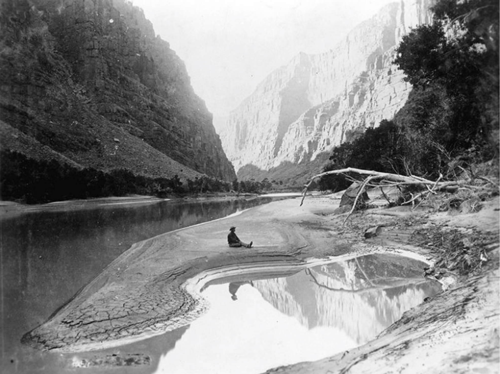
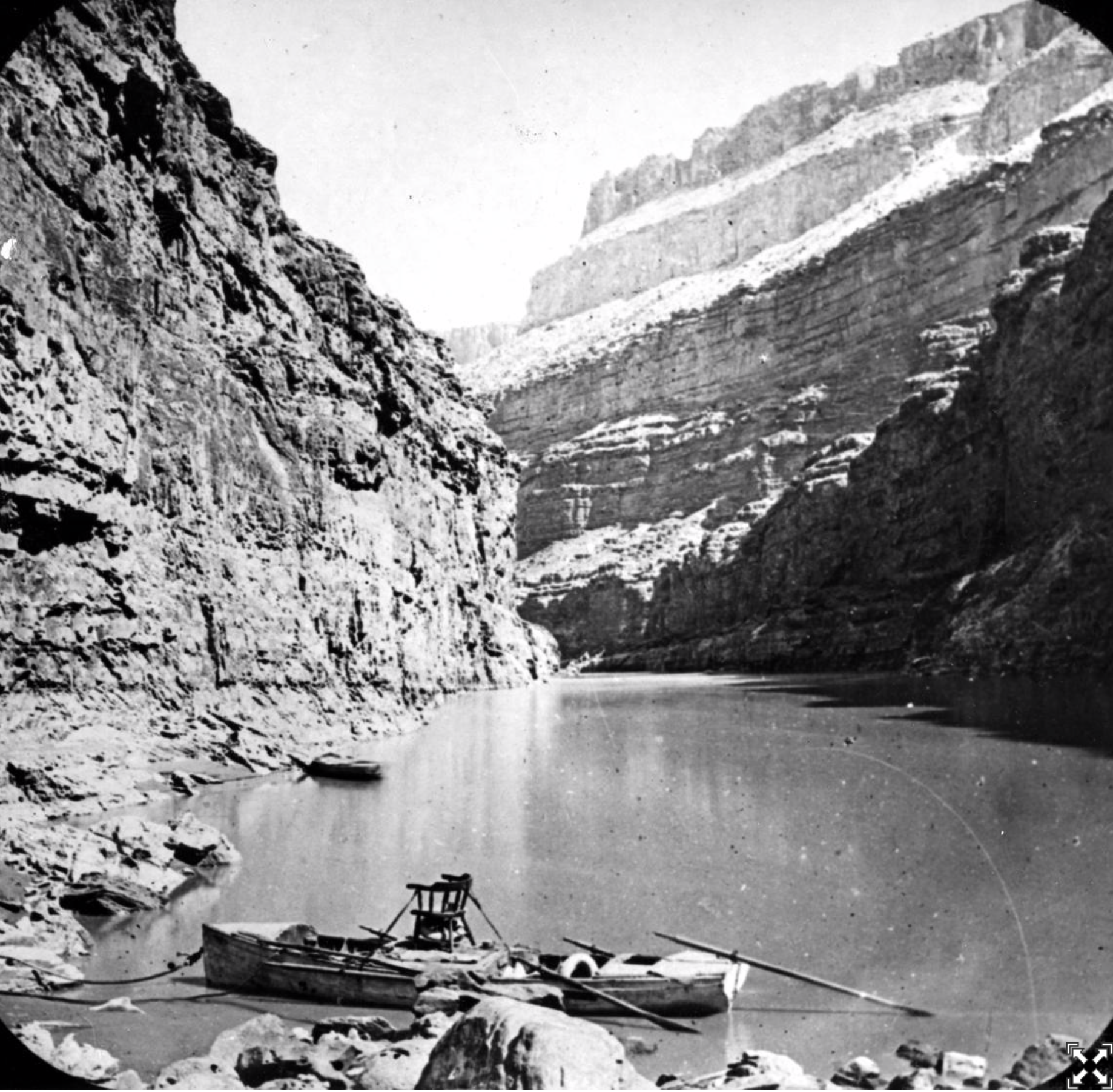
A stopover during Powell’s second expedition down the Colorado River. Note Powell’s chair at top center boat. Image: USGS
Follow us on Instagram as we track Powell’s journey over the next several months with National Geographic photographer Pete McBride.
One hundred fifty years ago this month, John Wesley Powell –scientist, explorer, and Union Civil War veteran (he lost his right arm at the Battle of Shiloh) – launched his wooden boat on the Green River in Wyoming in what would be the first scientific study and expedition down the Green and Colorado rivers.
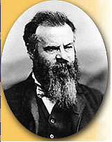
John Wesley Powell
Powell and his men mapped and described the wild rivers and stunning landscapes. His journal entries chronicled the whitewater rapids and challenges in the Colorado River’s Grand Canyon. River runners today read his words aloud around evening campfires: “We have an unknown distance yet to run, and unknown river to explore.”
In some ways, Powell was clearly a man of his time. Like other explorers of the American West, his work ultimately caused tremendous harm to Native American communities, opening traditional lands to development and exploitation and supporting government efforts to exterminate traditional ways of life.
In other ways though, Powell was far ahead of his time, particularly when it came to water. In 1878, he delivered his Report on the Lands of the Arid Region to Congress, which presented his ideas on how to encourage settlement of the west while respecting and conserving scarce water supplies.
“Many droughts will occur; many seasons in a long series will be fruitless,” he warned.
Lake Mead, behind Hoover Dam, shows the effects of nearly two decades of drought. (Image: Bureau of Reclamation)
Powell didn’t just sound the alarm about the perils of destroying scarce water resources with unchecked development. He presented solutions that, today, are more relevant than ever. He advocated planning around watersheds – the natural basins through which water flows — as opposed to using traditional political boundaries. His ideas around local decision-making, scrapping government subsidies for big water projects, and the importance of living within our means when it comes to water should help inform water management today.
The Green and Colorado rivers, and the communities along their banks, have changed a lot in 150 years. And while climate change now poses serious threats to our rivers and water resources, there is cause for hope. Today, we have a new generation of explorers and pathfinders – one that, unlike Powell and his 19th century comrades, includes indigenous, Latinx and others who are blazing new trails toward equitable water solutions and a more sustainable future.
We’re also seeing unprecedented collaboration among states that share Colorado River water, to ensure the west will be a place of thriving cities, productive agriculture and a healthy environment for generations to come.
As we mark the anniversary of Powell’s exploration, we should amplify Powell’s calls for water sustainability and stewardship in the west and nationwide. We should also learn from the mistakes of the past by ensuring that historically marginalized communities and communities of color play a lead role in making critical decisions about rivers and water. When it comes to managing our most precious natural resource, water, for the next 150 years and beyond, we must chart this course together.
No photos were taken during John Wesley Powell’s pioneering 1869 expedition of the Colorado River. This photo, taken along the Green River in northern Colorado, dates from Powell’s 1871 expedition, which retraced the 1869 journey. Credit: National Park Service
FromEarth and Space Science News (Korena Di Roma Howley):
One hundred fifty years ago, the explorer and scientist argued that the West needed smart development. Now the fast-growing region is playing catch-up.
The American West, while steeped in mythology, is also a region that depends heavily on science for its long-term livability—and perhaps no one was quicker to realize that than John Wesley Powell. A Civil War veteran and an indefatigable explorer, Powell landed on the national stage in 1869, after an expedition he led became the first to navigate the Colorado River’s path through the Grand Canyon.
In the decades that followed, Powell would argue that careful, democratic management of water resources in the West must be a crucial component of its development and that a pattern of settlement and land cultivation based on the 19th century status quo would prove unsustainable.
He couldn’t have had a more unreceptive audience. Elected officials, industry titans, and even fellow scientists wanted a narrative that better supported the westward march of “progress,” narrowly defined.
Fast-forward 150 years, and Powell’s 19th century appeals are making modern headlines on the strength of their perception and foresight. Even while western states lead the nation in population and economic growth—Arizona, Colorado, Nevada, and Utah were among the top five states with the fastest growing gross domestic product between 2016 and 2017—drought conditions that have persisted for decades have left parched cities under constant threat of water emergencies.
On the Colorado River, the country’s two largest reservoirs—Lake Mead on the border between Nevada and Arizona and Lake Powell (so named for John Wesley) on the border between Arizona and Utah—are being drained faster than they can replenish. The effects of climate change are only adding to the pressure on limited water supplies.
In Powell’s account of his explorations, published in 1895 as Canyons of the Colorado, he describes the river’s waters emptying “as turbid floods into the Gulf of California.” Today, only in very wet years does the river reach the ocean. Meanwhile, communities that rely on the Colorado for water, including sprawling metropolitan areas like Phoenix, Denver, and Los Angeles, are facing the possibility of having their supply cut off or severely limited in a future that’s moving alarmingly nearer.
Unforeseen Potential
It’s tempting, then, to imagine how the West might have evolved had Powell’s vision for its development been implemented, rather than shunned, a century and a half ago.
What if Congress, undeterred by the siren song of American expansion, had listened to the call of the pragmatic?
Would L.A. be a backwater?
Would Tucson even appear on the map?
Would the Colorado still rush freely to the gulf from its headwaters in the Rocky Mountains?
Speculation about what might have been is complicated by society’s shifting priorities and values, as well as by technology. Powell, for his part, envisioned much smaller communities dispersed over the western landscape.
“One thing that he didn’t anticipate [was] the degree to which we would accumulate western society in big, urban complexes,” says Jack Schmidt, the Janet Quinney Lawson Chair in Colorado River Studies at Utah State University and former chief of the U.S. Geological Survey’s (USGS) Grand Canyon Monitoring and Research Center.
Powell, Schmidt says, might not have imagined that these urban complexes “would have these tentacles that extended way out into the distant landscape [or] the degree to which these big urban centers would be maintained by these really long canals…these really complicated electricity transmission systems that bring in power from distant coal-fired and nuclear and hydroelectric dam facilities.”
Although Powell’s vision of small communities was largely focused on irrigated agriculture, water management, he thought, would be developed at a more local scale. This would, among other benefits, help to hedge against the uncertainties of climate variation. When, for instance, the 1922 Colorado River Compact apportioned shares of Colorado River water to seven states, it was during a particularly wet period, leading to overestimated water allocations.
“One of the big things that would’ve happened if we’d listened to Powell is that we…would have responded earlier to the information about global climate change,” says John F. Ross, author of The Promise of the Grand Canyon: John Wesley Powell’s Perilous Journey and His Vision for the American West. “He was a great proponent of America’s potential; he just wanted to do it in a way that was sensible to what was on the ground.”
When the West Was Young
In 1869, as the post–Civil War United States was knitting itself back into a union, the sparsely settled expanse of states and territories that stretched between the 100th meridian and the Pacific coast was still a great unknown for many Americans. That year, Ulysses S. Grant was inaugurated as the 18th president of the United States, Wyoming became the first U.S. state or territory to grant women’s suffrage, and a spike driven at Promontory Summit in Utah connected the country’s first transcontinental railroad.
To many communities in the East and Midwest, the newly accessible West was brimming with possibility and scarcely tapped resources. John Wesley Powell, then a professor of geology at what is now Illinois State University, had identified an opportunity as he contemplated the last blank spot on the map of the continental United States: the Colorado Plateau. Today it’s an area made up of eight national parks—including Arches, Zion, and Grand Canyon—and nearly two dozen national monuments, historic sites, and recreation areas. In Utah alone, the region’s five national parks brought in 15.2 million visitors in 2017.
But in the late 19th century it was an altogether different story. When Powell undertook the 3-month descent of the Colorado River in the name of science, the journey was considered by some to be all but suicidal. Still, the Union Army major—who was wounded while fighting in the Battle of Shiloh—conquered the unpredictable 1,600-kilometer route with one arm, a small fleet of wooden rowboats, and a cobbled-together team of nine willing but inexperienced adventurers (all white men).
The expedition departed from Wyoming’s Green River City on 24 May 1869, with 10 months’ worth of supplies, an optimistic collection of scientific tools, and, among some of the men, hopes of finding a fortune. Four men would eventually abandon the expedition, one at the first opportunity and three others less than 2 days before the remaining team successfully emerged from the Grand Canyon. (Those three men were never seen or heard from again.)
lthough Powell’s scientific ambitions for the expedition were largely scuttled by the demands of survival, the widely heralded trip would help to launch his decades-long career as a geologic surveyor, shrewd political player, and government administrator. His recommendations to Congress would be instrumental in the creation of the U.S. Geological Survey, and he would later serve a dozen years as its director while also leading the Smithsonian’s Bureau of Ethnology and helping to found the Cosmos Club and the National Geographic Society.
But it was Powell’s unswaying advocacy for land and water management in the West that would prove to be one of his most remarkable legacies.
A Watershed Idea
It was the railroad that made it possible for Powell and his team to launch the expedition from the banks of the Green River. The conveniently located station at Green River City meant that Powell could easily bring his boats and supplies by train. But the technology that benefited Powell’s plans in 1869 would also facilitate the idealistic expansion that he would ultimately spend the latter part of his career warning against.
The completion of the transcontinental railroad was especially timely for a nation in pursuit of Manifest Destiny, which disregarded the realities of climate and the native peoples who occupied the land in favor of spreading American industrialism and progress from coast to coast. Politicians, speculators, and homesteaders were eager to exploit the promise of the West’s seemingly endless resources and would be quick to deny the hard truth that lives and livelihoods depended on one all-important ingredient: water.
In his 1879 Report on the Lands of the Arid Region of the United States, with a More Detailed Account of the Lands of Utah, with Maps, Powell foresaw the consequences of applying American optimism—and opportunism—in a part of the country where annual rainfall measured below 50 centimeters a year. He warned that there wasn’t enough water to support large-scale farming or the rapid settlement of federal lands stimulated by the Homestead Act of 1862. In addition, the costs of establishing effective irrigation systems threatened to keep control out of the hands of small farmers.
Certain conditions, Powell said, had to be met to develop the region successfully, including the identification of irrigable areas and local control of dam and irrigation projects.
It was a position Powell would refuse to abandon.
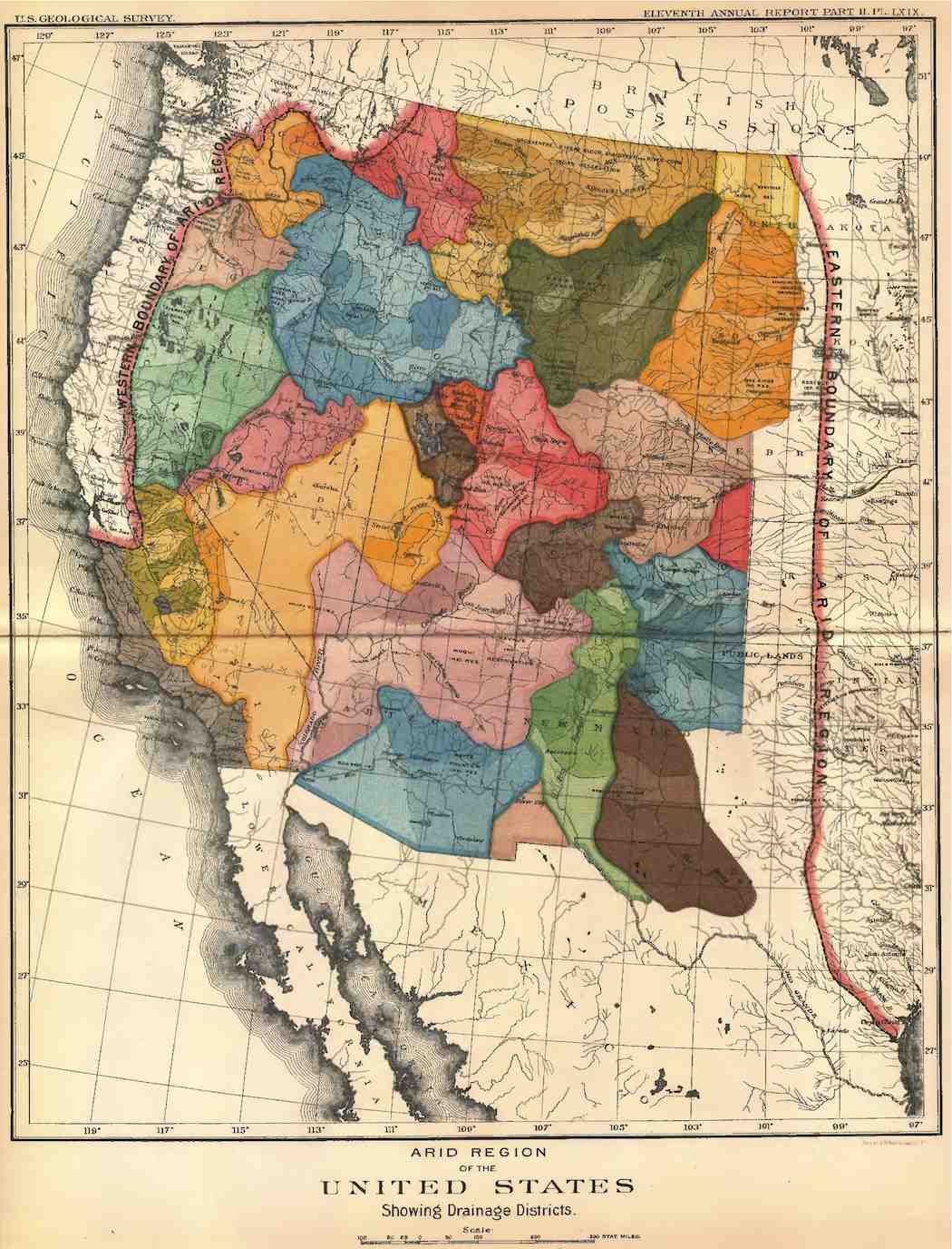
John Wesley Powell’s recommendation for political boundaries in the west by watershed
While testifying before a congressional committee in 1890, when he was head of the USGS, Powell deployed a unique visual aid: a map that divided the western states and territories into a series of drainage districts.
On first viewing, it’s a surprising example of 19th century cartography, made all the more striking with rich colors and irregular, organic-looking boundaries that contrast sharply with the boxy borders we’re familiar with today.
But the schematic didn’t hold water, so to speak, with a nation determined to grow and expand. The outlook of the nation was invested in myths that encouraged development and defied science, whereas Powell, Schmidt says, lacked the tolerance for pursuing such myths, including the widely held belief that “rain follows the plow.”
In 1902, the year Powell died, Congress passed the Reclamation Act to “reclaim” the arid region for agriculture and settlement.
“That set the stage for this really large-scale water development in the West that almost defied the functioning of the watershed from an ecological perspective,” says Sandra Postel, founder and director of the Global Water Policy Project and author of Replenish: The Virtuous Cycle of Water and Prosperity.
Today, “the river is really operated more according to needs for hydropower, flood control, irrigation, and water supply,” Postel says. “You couldn’t have cities like Las Vegas and Los Angeles and Phoenix and Tucson without this extra water.”
Although deeply unpopular at the time, today, it’s apparent that Powell’s insistence on viewing the West’s water problem with scientific objectivity was a forward-thinking approach. Now science is taking a leading role in helping to reclaim the region for the environment while facilitating ways for a growing population to live there sustainably.
Powell believed that “science is a process of continually improving the details of our understanding of natural processes, and he would be very proud of the role of science in informing river management and protection,” says Schmidt.
According to Ross, Powell set the stage for the type of conversation we should be having about our natural resources. “He introduced the idea that arid cultures either stood or fell…not on the absolute amount of water, but on how equitably—politically and economically—the system divided that resource,” he says.
And what lessons can be taken from Powell as the West moves forward?
Says Ross, “We’re seeing this kind of bioregionalism now, where decisions are made not by the federal government but on a more local, or regional, basis—[which is] really the only way to work out these very knotty issues.”
Postel says that successful restoration often involves collaboration, such as conservationists working with farmers to find solutions to water management issues.
“If we get smarter about using and managing water, we can do better with what we’ve got than we’re currently doing,” she says.
As the challenges and accomplishments of western settlement continue to ebb and flow, Powell’s influence still lingers.
Like Postel, Schmidt believes that the key to water management in the West is in working together as a watershed community. “In a sense, that’s an idea of Powell’s that still exists today. It’s just that the community that we call the watershed includes the entire Colorado River basin. It includes every one of the seven states, all sitting around the table together.”
—Korena Di Roma Howley (korenahowley@gmail.com), Freelance Journalist
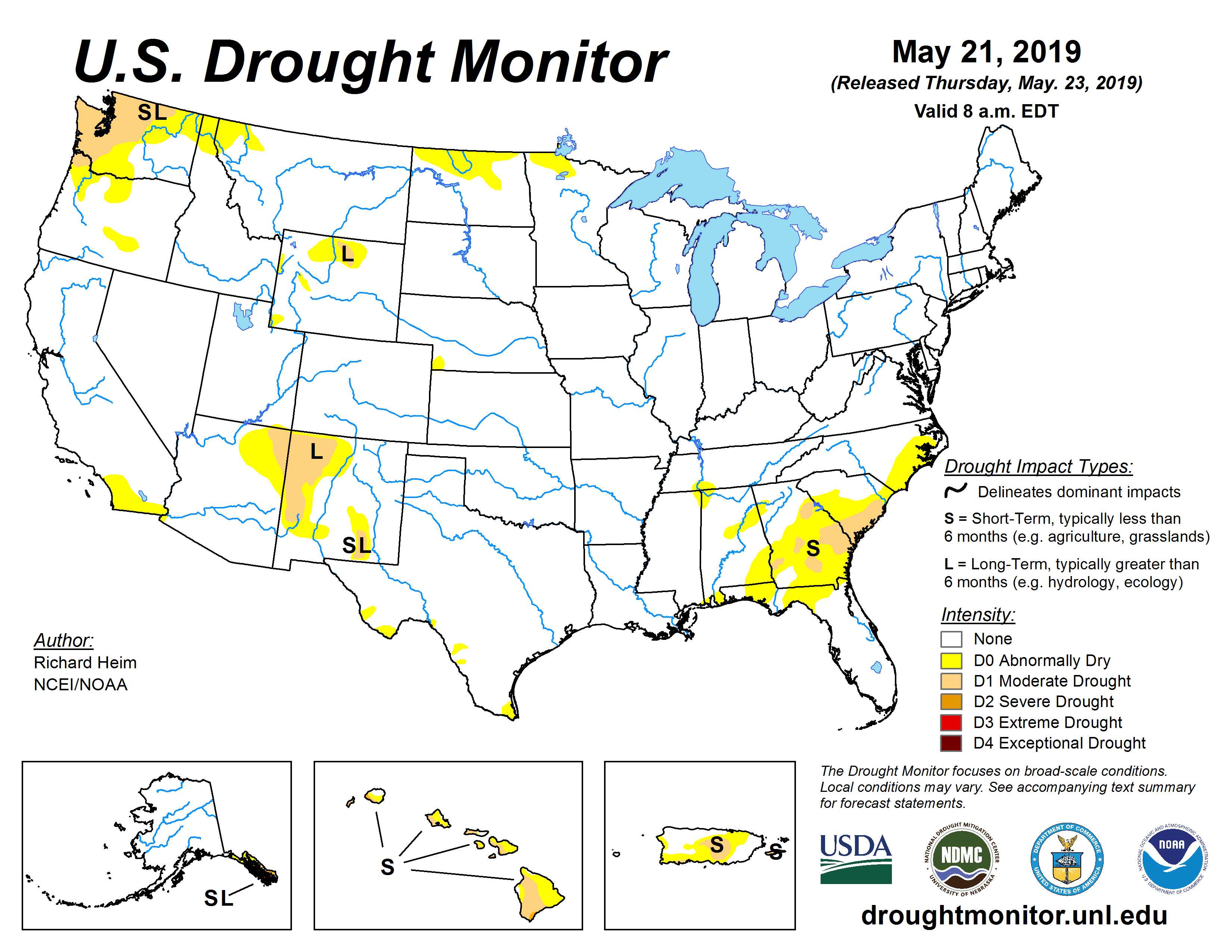
A wet winter and spring rains mean this is the first week in 20 years in which there were no significant drought conditions in the lower 48 states, the United States Drought Monitor reported.
“The good news is that just like the rest of country, none of Arizona remains in a severe or exceptional drought,” Phoenix National Weather Service meteorologist Marvin Percha said. “It’s great news in short and medium terms of fire danger levels and water supplies.”
A recent tweet from NOAA’s National Centers for Environmental Information cites “wet conditions” as the source of this shift in the country’s drought levels.
According to Percha, much of the country has seen wetter than normal conditions over the last few years.
“Of course, here in Arizona, we had all the rain from the remains of Hurricane Rosa and Sergio, and a decently wet winter,” he said…
Even as the drought has eased across the Southwest, concerns remain that the region’s 19-year run of mostly dry years could continue, especially as global warming adds to strains on water supplies.
Earlier this month, a group of experts in a state advisory group recommended to Gov. Doug Ducey that a declaration of drought in Arizona should remain in effect.
Reservoirs on the Colorado River, which supplies about 40 percent of Arizona’s water, have declined dramatically in recent years. And one wet winter isn’t projected to be enough for Lake Mead and Lake Powell to recover.
The Colorado Climate Center says just .01 percent of the state is still classified as abnormally dry.
“Two pixels in Montezuma and Yuma Counties that are too small to even see on the map,” the center wrote on Facebook. “With more precipitation in the forecast, it’s possible the map will be wiped completely clean in next week’s map!”
It’s the lowest number since the U.S. Drought Monitor was established nearly 20 years ago.
Colorado Drought Monitor February 12, 2019.
The numbers are a stark turnaround from February when two-thirds of the state was classified at some degree of drought. Even in late March following a bomb cyclone and a historic avalanche cycle, nearly half the state was still in a drought.
Meteorologists say an active jet-stream pattern that set up over Colorado in mid-February set off the dramatic about-face. April and May continued the trend with predominantly wetter-than-usual and cooler-than-usual weather.
FromColorado Public Radio (Michael Elizabeth Sakas, Natalia Navarro and Kelley Griffin):
Drought is officially over in the state, for the first time in 19 years. Farmers can maintain crops and livestock. Colorado could get through this wildfire season without seeing massive fires like last year’s.
And Denver Water is pleased as reservoirs rise. Snowpack in the Colorado River basin is 145 percent of normal, while the South Platte is at 124 percent. Those mountain areas serve Denver Water’s 1.4 million customers on the front range, as well as other communities like Aurora and Littleton.
But as the snow melts, it takes a fine-tuned approach to manage the flowing water that rushes down mountainsides and through tunnels, into reservoirs and over spillways and along creeks and rivers.
Some mountain communities are bracing for it to go badly. Hinsdale County in southwestern Colorado is stocking up on sandbags while trying to head off the flooding that can result from raging streams clogged up by the debris churned up by avalanches.
The Best Case Scenario
Denver Water manager Nathan Elder said so far things are going well.
“The cool temperatures have really slowed runoff down and it’s occurring in a more controlled way, to contrast if we had a really hot, sunny spring where it all melts really quick,” which can cause flooding, Elder said.
He checks lots of data every week — snow pack of course, but also projected temperatures that affect the rate of snow melt; windy weather, which alters how much snow evaporates; and soil moisture, to calculate how much snowmelt will get soaked up by the ground and never make it to reservoirs.
After noting all that, Elder decides how much room to maintain in reservoirs including the one in Dillon so it won’t overflow.
“We’re currently holding Dillon Reservoir steady at 25 feet-down (from full) to prepare for that snowpack runoff,” Elder said…
People in the remote county, which sits east of Telluride in the Rio Grande and San Juan national forests, have seen more avalanches this winter than anyone can remember. Twelve slides were big enough to get names. The slides left massive debris fields, dotted with whole trees and large boulders, said Michael Davis, the public information officer for the Hotchkiss Fire District. Davis is helping coordinate the emergency planning in Hinsdale County.
Hinsdale is considered the most remote and roadless county in the lower 48 states. While most of those avalanches don’t directly affect residents, the trees and boulders pulled along in the slides do cause problems. All that debris jams up old earthen dams in the mountains designed to manage the flow of the Henson Creek. Now, officials are worried the dams could break.
“If that should happen, then we would end up with a large volume of water shooting down the Henson creek, carrying massive amounts of debris into Lake City,’ Davis said.
Experts from federal, state and county agencies are working to avert such a flood, but it isn’t easy. The remoteness of the county means there are few roads to deliver equipment into the areas where they need to clear debris.
Officials are blocking a couple of county roads that would normally open up Memorial Day weekend because they don’t want the public in canyons that could be swept by flooding.
Because officials are so closely monitoring on the creek, if the worst does happen, Davis said they’ll be able to give residents plenty of advance warning to get out,.
The county has also called for volunteers to fill sandbags.
With the latest report from the National Drought Mitigation Center, Colorado is free from drought, and has just 0.01 percent of the state in abnormally dry conditions.
At the start of the calendar year, two-thirds of the state was experiencing some level of drought, and only 18 percent was drought-free. Exceptional drought – the worst category – covered 11 percent of the state, while an additional 16 percent was under exceptional conditions. At its peak in late 2018, nearly half of the state was in the two worst categories.
The last time Colorado was nearly completely free from drought and abnormal dryness was nearly 10 years ago in late July and early August 2009. At that time, just 0.28 percent of the state was abnormally dry. Ninety-eight percent of the state was drought free in mid-August 2015…
Severe drought was eliminated in New Mexico this week, marking the first time in the history of the United States Drought Monitor that the continental U.S. had been free from severe, extreme, and exceptional drought. At the same time extreme drought made its first-ever appearance in Alaska.
Drought-free conditions have visited Colorado for the first time in nearly two years, and the state is in a better water position than it has been in the past two decades…
Greeley
For cities like Greeley, being out of the drought is good, but it’s not life-changing. Greeley draws water from four river basins, and has many high-mountain reservoirs for storage. Those redundancies help the city weather dry years, meaning Greeley doesn’t live by the snowpack every single year.
Still, a strong snowpack and a run of several wet years would allow Greeley to save more water in its reservoirs. It’s also allowing Greeley to sell more of its water to farmers and ditch companies…
Farmers and agriculture irrigation companies
Years with better snowpack and higher, longer river flows are great for both parties. There’s more water to go around for everybody. It’s called a “free river,” and it’s something that hasn’t happened very often in the past couple of decades. In dry times, only the senior-most water rights holders can draw from the river while others have to dry up their fields or ditches or reservoirs.
This year will likely feature more “free river,” meaning there’s no seniority-based call on the river, for a longer period of time, meaning ditches will run, reservoirs will fill and fields will soak up the riches.
When asked who the big winners were in wet years, Jim Yahn, the South Platte Basin Director for the Colorado Water Conservation Board, said it’s definitely agriculture. Then he kept adding other winners in.
“When you have good flows, wet lands, environmental and recreation uses — those are all winners,” he said.
Colorado River basin folks
For Yahn, the wet year adds momentum to a basin that’s gotten quite a bit of attention recently, including the recent signing of a drought contingency plan with the seven basin states and Mexico.
“That’s a good thing,” Yahn said. “A drought kind of makes people come together and look at a basin a little bit differerently and come up with ways to handle this across the board.”
That basin also supplies the Front Range via the Colorado-Big Thompson Project, which Northern Water manages.
City [of Aspen] officials are recommending that Aspen City Council lift water restrictions enacted a year ago when the area was experiencing drought conditions.
Things have changed and officials with the public works and utilities department feel that the restrictions, which limit outdoor irrigation and impose surcharges on large water users, are not necessary going into this summer.
From the Eagle River Water & Sanitation District (Diane Johnson) via The Vail Daily:
The federal snow measuring site on Vail Mountain received 2.2 inches of “snow water equivalent” in two days this week. Snow fell at about that rate in early March. Remember those pow days? The site has accumulated 3.7 inches of snow water equivalent since May 1. That’s how much it received between October 2018 and Thanksgiving — more than enough for Vail Mountain to open early with great conditions.
While May snow and cold temperatures have caused local rivers to slow down, we know the snow will eventually melt, which likely means some great whitewater. Beyond recreational pursuits, heavy May precipitation means lots of water has seeped into local soils. That’s a good thing for our forests and yards.
A big change from last year, when the Vail Mountain site “melted out” on May 15, summer rains failed to materialize, and soils quickly dried out, along with local waterways.
Historical perspective
It’s unusual to get this much snow water equivalent in May, but not unheard of. It happened in 2008, 2003, 1999, 1995, 1984, 1983 and 1979 — the first year the federal site operated on Vail Mountain (on the heels of sustained, multi-year drought).
In other years — notably 1981, 2002, 2012, 2015 and last year — snow was rapidly melting or gone by now. Each of those years but 2015 turned out to be a big drought year in Colorado.
These differences in May weather demonstrate the variability in local precipitation and why it’s important to plan your landscape for that variability.
The water you use to sustain the outdoor spaces at your home or business depends on an adequate water supply. If you have native plants adapted to Colorado’s semi-arid climate, you probably don’t worry much about whether it’s wet or dry. If supplemental water is necessary for your landscape to thrive, that water comes from Eagle River Water & Sanitation District or your local water provider, who relies on that same variable snowfall and rain to produce clean water for indoor and outdoor purposes.
In years such as 2018, when drought caused local waterways to drop to very low levels, we prioritized river water over customers’ use of water for outdoor purposes. Outdoor areas use much more water than indoor areas and landscape irrigation has a greater impact on streamflows than indoor water use. Our staff contacted hundreds of customers who were using excessive amounts of water that disproportionately impacted our community’s limited water resources.
Putting our waterways first
That scenario is unlikely this summer, but our priorities are the same. Healthy waterways are critical to our natural environment and recreation-based economy, so we strive to balance our customers’ water needs with the rivers’ needs.
Our commitment to efficient use of our community’s water resources is just as strong, so we urge our customers to modify landscapes to ones that use water efficiently. Over the years, we have worked with many customers who were wasting water and did not know it. Armed with some information about “normal” water use and irrigation system settings, many people have happily reduced their water use, saved money and still enjoy having a beautiful yard.
One way to know whether you’re using a sensible amount of water is to check the “usage tier” in which you are billed. Customers who use water in Tier 1 have low or normal water use and pay the lowest rate. Water used in higher tiers is progressively more expensive; use in Tiers 4 and 5 is considered excessive.
Another way to better understand, and control, the water used at your home or business, is to learn about, and sign up for, WaterSmart, which is a new online tool for our customers. Rather than waiting for a monthly water bill, WaterSmart will give you almost real-time information about your water use.
Sound interesting? We hope so. Your first opportunity to learn about it includes a free lunch. Just go to the town of Vail’s Lunch with the Locals program at noon on May 29 in Lionshead Village. You can hear about it, ask questions and learn how to take control of your water use.
Diane Johnson is the Communications & Public Affairs Manager for the Eagle River Water & Sanitation District. ERWSD provides efficient, effective, and reliable water and wastewater utility services in a manner that respects the natural environment. ERWSD’s water service area is Vail and Wolcott, while the wastewater service area is Vail to Wolcott. ERWSD also operates and maintains, by contract, the Upper Eagle Regional Water Authority public water system, which provides water service to Arrowhead, Avon, Bachelor Gulch, Beaver Creek, Berry Creek, Cordillera, EagleVail, and Edwards.
If you had a choice between a better, faster cell phone signal and an accurate weather forecast, which would you pick? That’s the question facing federal officials as they decide whether to auction off more of the wireless spectrum or heed meteorologists who say that such a move could throw U.S. weather forecasting into chaos.
On Capitol Hill Thursday, NOAA’s acting chief, Neil Jacobs, said that interference from 5G wireless phones could reduce the accuracy of forecasts by 30 percent. That’s equivalent, he said, to the quality of weather predictions four decades ago. “If you look back in time to see when our forecast scale was roughly 30 percent less than today, it was 1980,” Jacobs told the House Subcommittee on the Environment.
That reduction would give coastal residents two or three fewer days to prepare for a hurricane, and it could lead to incorrect predictions of the storms’ final path to land, Jacobs said. “This is really important,” he told ranking committee member Frank Lucas (R-Oklahoma).
In March, the FCC began auctioning off its 24-gigahertz frequency band to wireless carriers, despite the objections of scientists at NOAA, NASA, and the American Meteorological Society. This week, Senators Ron Wyden (D-Oregon) and Maria Cantwell (D-Washington) wrote to FCC chair Ajit Pai requesting the commission stop companies from using the 24-GHz band until a solution is found, and to delay any more of the auction.
Jordan Gerth, a research meteorologist at the University of Wisconsin, Madison, has been studying this issue as part of a group at the American Meteorological Society. He says that while the FCC can switch which regions of the spectrum it allocates to phone companies, forecasters are stuck. That’s because water vapor emits a faint signal in the atmosphere at a frequency (23.8 GHz) that is extremely close to the one sold for next-generation 5G wireless communications (24 GHz). Satellites like NOAA’s GOES-R and the European MetOp monitor this frequency to collect data that is fed into prediction models for upcoming storms and weather systems.
“We can’t move away from 23.8 or we would,” Gerth told WIRED. “As far as 5G is concerned, the administration has a priority to put 5G on the spectrum, and they thought this was an OK place to do it. It’s just close to where we are sensing the weather.” Gerth says that wireless carriers could turn down the power emitted by 5G cellphone transmitters so they don’t drown out the sensitive sensors on the satellite. NOAA and NASA want to limit the interference noise to a level closer to what is considered acceptable by the European Union and World Meteorological Organization.
NOAA’s Jacobs told the House committee that the number currently proposed by the FCC would result in a 77 percent data loss from the NOAA satellite’s passive microwave sounders. He also said that experts from the two agencies are trying to work out a compromise. “I’m optimistic we can come up with an elegant solution,” he told lawmakers Thursday.
In the meantime, Gerth says this issue probably won’t go away anytime soon. The FCC plans future 5G auctions for the radio frequency bands near ones used to detect rain and snow (36–37 GHz), atmospheric temperature (50.2–50.4 GHz), and clouds and ice (80–90 GHz). “This is not one and done,” Gerth added. “Today it’s 23.8, tomorrow it’s 36.”
The state department is negotiating with other nations over the interference level, which will be settled at a world radio conference in October. The FCC’s 5G auction has reaped nearly $2 billion from both small and large wireless providers and is still underway.
New plan aims to protect water supply across the Southwest after years of drought. The post States sign agreement to help boost Lake Powell and Lake Mead appeared first on News on TAP.
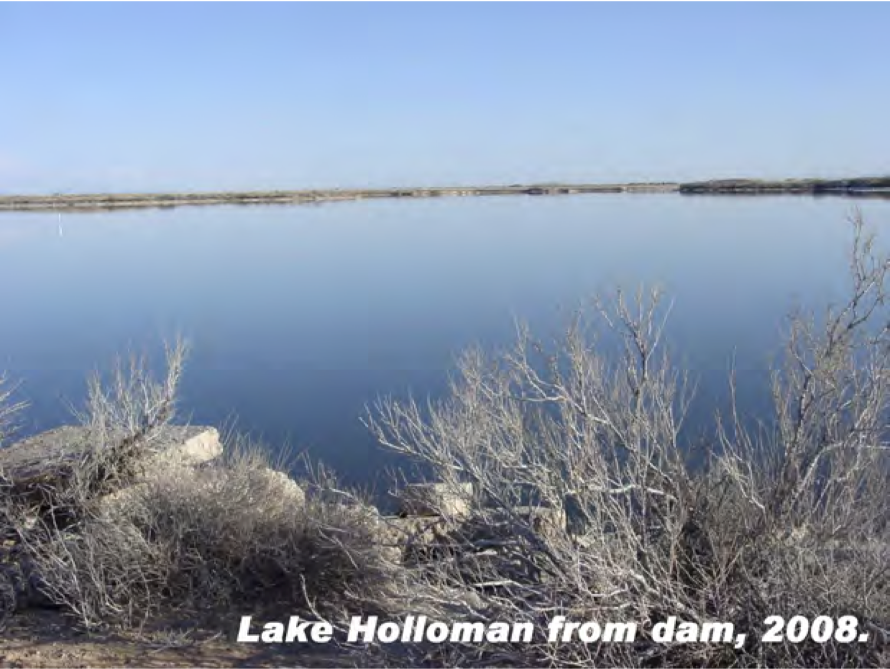
Holloman Lake 2008 via the New Mexico Environment Department
FromThe New Mexico Political Report (Laura Paskus):
New Mexico officials find themselves stonewalled by the United States military over water contamination from two U.S. Air Force bases in the state.
In early May, New Mexico Attorney General Hector Balderas and New Mexico Environment Department (NMED) Secretary James Kenney sent a letter to the U.S. Air Force over contamination, this time at Holloman Lake.
Previously, groundwater tests at Cannon Air Force Base in Clovis and Holloman Air Force Base in Alamogordo showed high concentrations of PFAS, or per and polyfluoroalkyl substances.
Even in small amounts, exposure to these toxic, human-manufactured chemicals increases the risk of testicular, kidney and thyroid cancer and problems like ulcerative colitis and pregnancy-induced hypertension. PFAS include perfluorooctanoic acid (PFOA) and perfluorooctane sulfonate (PFOS).
In response to the groundwater contamination, New Mexico issued notices of violation against the military in late 2018 and again earlier this year. The state also filed a complaint in federal district court, asking a judge to compel the Air Force to act on, and fund, cleanup at the two bases.
But New Mexico is also a defendant in a separate case. After NMED issued a notice of violation against Cannon, the Air Force sued New Mexico, challenging the agency’s authority to compel PFAS cleanup under its state permit…
Moving up the food chain
PFAS’s move through the groundwater, and they’re persistent, which means they stick around for a long time. They also move up the food chain, accumulating more and more within each species.
Scientists have found PFOS in fish-eating birds, even those in remote marine locations. And in Michigan—another state grappling with PFAS contamination from military bases—scientists found PFOS in the muscle of deer living near the former Wurtsmith Air Force Base. That state issued a “do not eat” advisory for deer harvested within that area.
Holloman Lake is also considered an important area for birds, including migrating ducks. According to the Audubon Society’s website, the lake is the most important area in the Tularosa Basin for shorebirds like Wilson’s phalarope and snowy plovers.
“The bottom line is that you’ve got a wetland complex that provides wintering and migratory bird habitat to thousands of shorebirds and waterfowl each year that is potentially contaminated by a bioaccumulating toxic chemical, that’s not a good thing,” said Jonathan Hayes, executive director of Audubon New Mexico. “Holloman Lakes is also one of a dozen or so sites in the state that are frequented by snowy plover, a species in drastic decline over much of its range and one that is likely to ingest toxic chemicals as they feed on aquatic invertebrates which make up the bulk of their diet.”
In addition to birdwatching, waterfowl hunting is allowed within certain areas at Holloman Lakes. Although the New Mexico Department of Fish and Game issues hunting permits and sets hunting season rules, the responsibility for closing the area to hunting would lie with Air Force officials.
Meanwhile, Balderas and Kenney are still waiting to hear back from the Air Force.
“We have not received a response to the letter sent by NMED and the Office of the Attorney General on May 9,” said NMED’s public information officer, Maddy Hayden. “We are also unaware of any actions the Air Force has taken in the interim to protect the public from exposure to PFAS at Lake Holloman.”